24
SHAPING HUBLI-DHARWAD AS A “CONNECTED CITY” Executive Report - Draft February, 2014 Directorate of Urban Land Transport Government of Karnataka
SHAPING HUBLI-DHARWAD AS A “CONNECTED CITY”Executive Report - Draft
February, 2014Directorate of Urban Land TransportGovernment of Karnataka

iiiii
We would like to acknowledge Ms. Manjula Vinjaluri IAS, Commissioner, Directorate of Urban Land Transport, Government of Karnataka for her support and inputs in developing an approach for this project.
We would like to thank Mr. Shashi Kumar, town planning member, HDUDA and Mr. P. L. Garag, superintending engineer, HDMC.
We would like to thank Prof. RJ Vasavada and Mr. VK Phatak for means of facilitating the project through access to information, knowledge, people and most importantly guidance.
We would like to thank Prof. Shivanand Swamy of CEPT, Dr. Halkatti (Retd. Director of ASI), Mr. Shailendra Singh (Special Officer, DULT) for their valuable inputs.
ACKNOWLEDGEMENTS
Introduction 4
Connected City 6
Need for T.O.D 8
Proposals 12
CompactDevelopment
TransitSupportiveUses
CompleteStreets
PublicSpaces
CulturalLandscape
IntegratedTransport
DemandManagement
Next Steps 40
Project Schedule 42
TABLE OF CONTENTS
This project would not have been possible without support and funding from Bloomberg Philanthropies. Our sincere gratitude to our donors and supporters.
Last but not the least the commitment shown by the members of the project team needs mention: Sanjay Sridhar, Himadri Das, Rejeet Mathews, Sonal Shah, Shreyas Srivatsa, Vivek Chandran, V.Surya Prakash, Mayura Gadkari, Aravinda Devaraj, Sudeept Maiti, Neha Mungekar, Binoy Mascarenhas, Nikhil Chaudhury, Srikanth Shastry, Jonas Knapen, Joseph Swain, Swapna Ann Wilson, Neelakshi Joshi and Natalia Lleras. We would like to thank many others who have been the support for surveys from Hubli-Dharwad and Bengaluru.

54
Dharwad
To Pune
To Panaji (Goa)
To Belgaum
To Bellary
To Bangalore
To Ankola
NH-4
NH
-4
NH-4
NH-63
NH-63
NH-218
To Bangalore
To Bellary
To Bijapur
Hubli
Navanagar
Dharwad
Hubli Airport
4
Project Inception
The Directorate of Urban Land Transport (DULT) and the North-West Karnataka Road Transport Corporation (NWKRTC) are pro-posing a Bus Rapid Transit (BRT) system between the twin cities of Hubli and Dharwad in northern Karnataka. Centre for Environ-ment Planning and Technology (CEPT) University, Ahmedabad is the BRT technical design consultant. The project is partly funded by the World Bank under the Sustainable Urban Transport Pro-gram (SUTP).
Collaboration
On the 12th of December, 2011, DULT and EMBARQ India signed a memorandum of understanding to demonstrate integration of land use and transport around the proposed BRT project connecting the twin cities of Hubli and Dharwad. A study was conducted in Hubli-Dharwad and a demonstration site was identified at Navanagar. The initiative was to serve citizens through the provision of improved mobility that is accessible, affordable, efficient, fast, frequent, comfortable, and safe.
Purpose
At EMBARQ India, we believe that using the TOD design principles, areas within walking distance of a BRT station can be shaped towards a more sustainable model of development. Creating more walkable, compact, mixed use and high-density development around such areas or nodes will provide safe, affordable and reliable transport options for larger number of people. It would also encourage increased public transport ridership thereby reducing overall travel time and the need to use private vehicles. Increased use of the BRT system will also ensure its financial sustainability.
In addition, these efforts would also directly provide improved air
quality and living conditions to a large segment of the population of Hubli-Dharwad. The project at Navanagar also encourages the concentration of people around employment generating zones thereby reducing work trips. EMBARQ India’s proposal consists of seven principles, two of which, namely complete streets and public spaces, have been taken up for implementation currently.
Outcomes
Projections for the Hubli Dharwad / Navanagar Area over the 10 years after plan implementation include:
2015
Increase in BRT ridership due to better accessibility and higher densities located at walkable distances to BRT.A 30% increase in ridership from 1.2 lakh to 1.66 lakh people.6 lakh people expected to benefit from the creation of public spaces integral to the project.
Reduction in travel times by 30% and travel distances by 20%.
2017 35 stations will have improved access and enhanced
pedestrian environments.
2020 At least 9. 8 lakh people will live in high density, mixed-use
and compact developments designed on TOD principles.
Figure 1: Local Planning Area of Hubli-Dharwad showing municipal boundaries and built-up areas (Data Source: BRTS Hubli Dharwad, DFR, October 2011, CEPT University)
IntroductionIntroduction | Executive Report - Draft
City ProfilePopulation (2011) 943,857
Decadal growth rate (2001-11)
20%
Corporation Area 202.3 sq.km
Conversion into Corporation
1962
No. of wards 67
Gross Density(per/sq.km)
4,666
No. of Properties 210,000
Sex Ratio 983
Literacy Rate 87%
Work Participation Ratio
32%
Location (Lat Longs) 15°21’52.95” N75°7’26.24” E
Altitude 670-762mts (above MSL)
Distance from Hubli(kms)
Bangalore - 410Hyderabad - 510Pune- 435Bellary- 210Belgaum-100Panji-185
Administrative District Dharwad
Nearest Airport Hubli
Nearest Railway Station
Hubli
Important Industries Automobile, General Engineering, Garments
INTRODUCTION
Railway line
Major Roads
Other Roads
Water Body
Built Area
HDMC Boundary
Local Planning Area
Bangalore
Hubli-Dharwad
Pune Bangalore Road
To A
mar
gol R
ailw
ay S
tatio
n
APMC
Amargol
Navanagar
Tech Park
Government Offices
KHB Layout
KHB Layout
Navan
agar
main Roa
d Amar
gol m
ain R
oad
EMBARQIndiaisinvolvedindevelopingaTODandaccessibilitydemonstrationprojectinNavanagar,preparationofaToRforNonMotorizedTransport(NMT)PlansfortheBRTstationsaswellasreviewingtheToRforrevisionofcomprehensivedevelopmentplanforHubliDharwad.
76
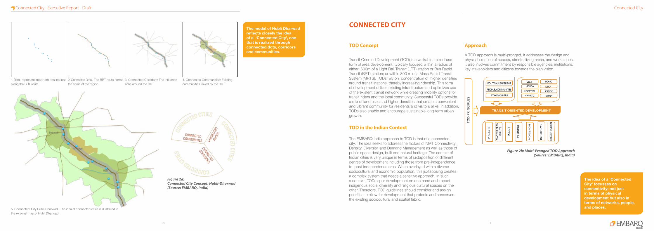
TOD Concept
Transit Oriented Development (TOD) is a walkable, mixed-use form of area development, typically focused within a radius of either 600m of a Light Rail Transit (LRT) station or Bus Rapid Transit (BRT) station; or within 800 m of a Mass Rapid Transit System (MRTS). TODs rely on concentration of higher densities around transit stations, thereby increasing ridership. This form of development utilizes existing infrastructure and optimizes use of the existent transit network while creating mobility options for transit riders and the local community. Successful TODs provide a mix of land uses and higher densities that create a convenient and vibrant community for residents and visitors alike. In addition, TODs also enable and encourage sustainable long-term urban growth.
TOD in the Indian Context
The EMBARQ India approach to TOD is that of a connected city. The idea seeks to address the factors of NMT Connectivity, Density, Diversity, and Demand Management as well as those of public space design, built and natural heritage. The context of Indian cities is very unique in terms of juxtaposition of different genres of development including those from pre-independence to post-independence eras. When overlayed with a diverse sociocultural and economic population, this juxtaposing creates a complex system that needs a sensitive approach. In such a context, TODs spur development on one hand and impact indigenous social diversity and religious cultural spaces on the other. Therefore, TOD guidelines should consider and assign priorities to allow for development that protects and conserves the existing sociocultural and spatial fabric.
Approach
A TOD approach is multi-pronged. It addresses the design and physical creation of spaces, streets, living areas, and work zones. It also involves commitment by responsible agencies, institutions, key stakeholders and citizens towards the plan vision.
Figure 2a:Connected City Concept: Hubli-Dharwad (Source: EMBARQ, India)
1. Dots: represent important destinations along the BRT route
2. Connected Dots: The BRT route forms the spine of the region
3. Connected Corridors: The influence zone around the BRT
4. Connected Communities: Existing communities linked by the BRT
5. Connected City Hubli-Dharwad : The idea of connected cities is illustrated in the regional map of Hubli Dharwad.
ThemodelofHubliDharwadreflectscloselytheideaofa‘ConnectedCity’,onethatisrealizedthroughconnecteddots,corridorsandcommunities.
Theideaofa‘ConnectedCity’focussesonconnectivity;notjustintermsofphysicaldevelopmentbutalsointermsofnetworks,people,andplaces.
TRANSIT ORIENTED DEVELOPMENT
DULT HDMC
HDUDA DTCP
HDBRTSCL KSSIDC
KIADBNWKRTC
POLITICAL LEADERSHIP
PEOPLE / COMMUNITIES
STAKEHOLDERS
PRO
JECT
S
WO
RKSH
OPS
INTE
RVIE
WS
PRES
ENTA
TIO
N
TRA
ININ
G
MA
STER
PLA
N IN
PUTS
POLI
CY
CONNECTED CITY
Figure 2b: Multi-Pronged TOD Approach(Source: EMBARQ, India)
TOD
PR
INC
IPLE
S
Connected CityConnected City | Executive Report - Draft

98
Dharwad
To Pune
To Panaji (Goa)
To Belgaum
To Bellary
To Bangalore
To Ankola
NH-4
NH
-4
NH-4
NH-63
NH-63
NH-218
To Bangalore
To Bellary
To Bijapur
Hubli
Navanagar
Dharwad
Hubli Airport
TOD in Indian Cities
Rapidly transforming urban centres in India are creating enormous economic opportunities on the one hand and posing a great infrastructural challenge on the other. As per the 2011 census, about 31% of the total Indian population live in cities (377,105,760 out of 1,210,726,932). Over 53 Indian cities house populations of over 1 million (from 35 cities in 2001). From 2001-2011, the total number of registered vehicles has increased from 55 to 142 million. During the same period, about 11.5 million vehicles have been added to the 10 metropolitan cities in India of which 95% are private vehicles. Such large numbers of private vehicles consume a substantial percentage of funds for infrastructure creation but with no respite from increasing congestion. Efficient public transport systems are the need of the hour and are beginning to be recognized for that purpose. Policy makers have understood the need for efficient public transport systems. The National Urban Transport Policy (2006) aims to encourage sustainable public transport systems in major cities across India. Many public transport projects are being taken up in terms of BRTS, MRTS, or LRTS. In order to be self supporting, public transport needs to be integrated with land use and housing and provide employment opportunities. In this context, TOD is the best strategy to optimize densities and to ensure effective use of resources for efficient and comfortable mobility options.
TOD in Hubli-Dharwad
Hubli and Dharwad are 20 km apart and are governed by Hubli-Dharwad Municipal Corporation (HDMC), created in 1962. Today, Hubli-Dharwad has spread across an area of over 202.3 sq. kms. The Hubli-Dharwad Urban Development Authority (HDUDA) was created in 1965 to undertake major infrastructure projects in both cities and their surrounding villages. A new township
named ‘Navanagar,’ a township in between the two cities has a good balance of residential areas along with institutional and commercial developments.
Hubli and Dharwad are connected by the Pune-Bangalore (P.B) Road which has seen tremendous growth of traffic in the last few years. In order to accommodate the increases in traffic, a road-widening project has been taken up along P.B. road. A BRTS has been conceived along the P.B. road between Hubli and Dharwad, in order to meet the increased demand for ridership. (Refer fig. 3.1)
TOD around the BRT Corridor
The Hubli-Dharwad area is currently undergoing rapid population growth. The proposed BRT will further fuel this growth. To cope with this, transit oriented development is proposed along the corridor. This BRT system will minimize sprawl and will serve as a ready to use commuter system for the additional population. Also, the proposed revision of the comprehensive development plan (CDP) for Hubli Dharwad in 2015 is an opportunity to incorporate the TOD principles. Incorporating TOD into the development plan will help in delivering efficient, comfortable and affordable mobility options to its citizens. Transit oriented development will (a) improve overall connectivity, (b) provide safety for walkers, cyclists and women, (c) prioritize public transportation and minimize private vehicle usage. This will minimize private vehicle usage. By adopting strategies like mixed land-use, high density, and small walkable block sizes, TOD will encourage walking and non- motorized travel modes.
Development triggers in the area are ongoing projects like the widening of P.B. road, upcoming Hubli Dharwad BRT, Hubli airport modernization, proposed electrification and doubling of
Figure 3: Hubli-Dharwad Municipal Corporation Limits : Showing TOD and feeder catchment zones (Data Source: BRTS Hubli Dharwad, DFR, Oct 2011, CEPT University)
ManypublictransportprojectsarebeingtakenupintermsofBRTS,MRTSorLRTS.Inthiscontext,TODisthebeststrategytooptimizedensitiesandtoensureeffectiveuseofresourcesforefficientandcomfortablemobilityoptions.
NEED FOR TRANSPORT ORIENTED DEVELOPMENTHubli-Dharwad BRT System at a GlanceTotal Length 22.5 Km
No. of Stops 33
Terminals 1 at Jubilee circle (Dharwad)
Volumes
Regular 3392 pphd
Express 6572 pphd
Frequency
Regular (Standard Bus)
2 mins
Regular (Convoy of two buses)
4 mins
Express (Convoy of two buses)
2 mins
Project Start Date Jan.2012
Project Finish Date Jan.2015
Project Area 68 acres
Project Cost 692 crores
Project Funding Govt. of Karnataka + World Bank
Agencies Involved
Design Consultant CEPT
Bus Operator NWKRTC
Road Widening KRDC
Proof Checking Wilbur Smith
Contractor GVK
Implementation HDBRTSCLSource: Directorate of Urban Land Transport (DULT), Govt. of Karnataka
Pune Bangalore Road
To A
mar
gol R
ailw
ay S
tatio
n
APMC
Amargol
Navanagar
Tech Park
Government Offices
KHB Layout
KHB Layout
Navan
agar
main Roa
d Amar
gol m
ain R
oad
Proposed TOD Corridor- Phase 1
Proposed TOD Feeder Route
Important Destinations
TOD Influence Zone-500m
Feeder Catchment-4Km
Railwayline
Major Roads
Other Roads
Water Body
Built Area
HDMC Boundary
Local Planning Area
Need for TODNeed for TOD | Executive Report - Draft
1110
the railway line, inland container depots, goods yard along with improved Mumbai-Chennai road corridor etc. High land values in Hubli and Dharwad have led to haphazard development adjoining PB road and it needs to be streamlined to ensure optimal utilization of the road widening as well as the upcoming Hubli Dharwad BRT.
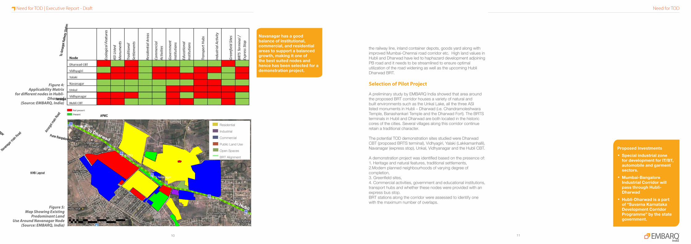
Selection of Pilot Project
A preliminary study by EMBARQ India showed that area around the proposed BRT corridor houses a variety of natural and built environments such as the Unkal Lake, all the three ASI listed monuments in Hubli – Dharwad (i.e. Chandramoleshwara Temple, Banashankari Temple and the Dharwad Fort). The BRTS terminals in Hubli and Dharwad are both located in the historic cores of the cities. Several villages along this corridor continue retain a traditional character.
The potential TOD demonstration sites studied were Dharwad CBT (proposed BRTS terminal), Vidhyagiri, Yalaki (Lakkamanhalli), Navanagar (express stop), Unkal, Vidhyanagar and the Hubli CBT.
A demonstration project was identified based on the presence of: 1. Heritage and natural features, traditional settlements, 2.Modern planned neighbourhoods of varying degree of completion, 3. Greenfield sites, 4. Commercial activities, government and educational institutions, transport hubs and whether these nodes were provided with an express bus stop. BRT stations along the corridor were assessed to identify one with the maximum number of overlaps.
B14 APMC
B13
B16 RTO
B15 Navanagar
B17 Iskon TempleTo Dharwad
To G
aman
gatt
i
To Hubli
Figure 4: Applicability Matrix
for different nodes in Hubli-Dharwad
(Source: EMBARQ, India)
Figure 5:Map Showing Existing
Predominant LandUse Around Navanagar Node
(Source: EMBARQ, India)
Residential
Industrial
Commercial
Public Land Use
Open Spaces
BRT Alignment
Pune Bangalore Road
To A
mar
gol R
ailw
ay S
tatio
n
APMC
Amargol
Navanagar
Tech Park
Government Offices
KHB Layout
KHB Layout
Navan
agar
main Roa
d Amar
gol m
ain R
oad
Navanagarhasagoodbalanceofinstitutional,commercial,andresidentialareastosupportabalancedgrowth,makingitoneofthebestsuitednodesandhencehasbeenselectedforademonstrationproject.
ProposedInvestments•Specialindustrialzone
fordevelopmentforIT/BT,automobileandgarmentsectors.
•Mumbai-BangaloreIndustrialCorridorwillpassthroughHubli-Dharwad
•Hubli-Dharwadisapartof“SuvarnaKarnatakaDevelopmentCorridorProgramme”bythestategovernment.
Need for TODNeed for TOD | Executive Report - Draft

1312
Principles of a Connected City
1. Compact DevelopmentEncourage high density, mixed-use development with a high level of services in places where people stay and work within walkable and biking distances.
2. Transit Supportive UsesProvide and intense mix of complementary activities like residential, commercial, institutional such that they allow safe use of public spaces and access to transit throughout the day.
3. Complete StreetsProvide safe access to people (walking or biking) that allows informal sector as well as vehicles and public transit.
4. Public SpacesProvide safe, comfortable and vibrant public spaces.
5. Cultural LandscapesConsider strategies to protect both tangible and intangible heritage and environmentally sensitive areas that may be impacted by intensification of development.
6. Integrated TransportEnsure efficient, comfortable, and safe shift from one transit to another.
7. Travel Demand Management Provide strategic parking for private vehicles, bicycles, rickshaws, auto-rickshaws and vendors.
The ingredients of successful TOD include strategic back-up such as a strong development climate and well designed master plans for multiuse, high-intensity developments supported by implementation strategies. They also include investments that promote the following :
• Easy and direct pedestrian, bicycle and public transit access
• Provide a safe, secure and attractive pedestrian environment
• Clear,readable signage as well as safe and comfortable environment to facilitate pedestrians
• Significant regional accessibility to major employment and activity centers
• Short, direct connections between transport modes and transit facilities
• Bicycle lanes and bicycle parking facilities at stations• Attractive facilities that are integrated with the
surroundings (public spaces, street furniture etc)• Safe and secure designs, including adequate lighting• Effective parking management around stations• Environmentally friendly technology options, such as
shared fleets of alternative (electric) vehicles located in neighborhoods
Source: Suzuki, Hiroaki, Robert Cervero, and Kanako Iuchi. 2013. Transforming Cities with Transit: Transit and Land-Use Integration for Sustainable Urban Development. Washington, DC: World Bank. DOI:10.1596/978-0-8213-9745-9
Ingredients for a Successful TOD
TheingredientsofsuccessfulTODincludestrategicback-upsuchasastrongdevelopmentclimateandmasterplansformultiuse,high-intensitydevelopmentssupportedbyimplementationstrategies.
Compact Development
Public Spaces
Transit Supportive Uses
Cultural Landscape
Integrated TransportTravel Demand Management
Complete Streets
PRINCIPLES OF A CONNECTED CITY PROPOSAL
ProposalPrinciples of a Connected City | Executive Report - Draft

1514
Pune Bangalore Road
To A
mar
gol R
ailw
ay S
tatio
n
APMC
Amargol
Navanagar
Tech Park
Government Offices
KHB Layout
KHB Layout
Navan
agar
main Roa
d Amar
gol m
ain R
oad
Figure 7a:Proposed FSI allocation in Navanagar as per the Revised Comprehensive Development Plan 2021 (CDP 2021)Source: EMBARQ India
Techpark,whichisfartherawayfromPBroad,hashigherFSIthaninstitutionalbuildingsadjacenttoPBroad.
Figure 7b: Existing Scenario (as per the proposed FSI in CDP 2021)Source: EMBARQ India
FSI 2.5
FSI 2.25
FSI 2.0
FSI 1.75
FSI 1.5
FSI 1.25
Proposed FSI(as per CDP 2021)
Comparative Densities of Revised Comprehensive Development Plan (CDP) 2021 and EMBARQ India ProposalParticulars
Prop
osed
in
Revis
ed C
DP
(202
1)
Prop
osed
by
EMBA
RQ In
dia
(203
1)
Population 65,500 65,500
Residential Density 307 410
Working Population density 167 361
FSI (max. allowed)
Residential 2.25 3.5
Commercial 2.5 3.5
Public and Semi public 2.5 3.5
Mixed -- 4
Existing population in study area (app.)- 16,500 (2011)
*Notes:1. Calculated based on the proposed land use map and associated building bye laws2. Plots with commercial axis is clubbed under residential use and plots with industrial use have been included under commercial use3. Currently mixed-use does not exist. EMBARQ India proposes 50% residential use and remaining with commercial, public semi-public or other original intended uses4. FSI in ASI regulated zone – 0.75. Assumptions for density calculations (residential use, High/Medium/Low – 20/25/30 sqm per person respectively; Commercial (Tech Park)-30 sqm/person; Commercial (APMC), Public and Semi-Public uses – 50 sqm/person)
Compact DevelopmentCompact Development | Executive Report - Draft
1716
Pune Bangalore Road
To A
mar
gol R
ailw
ay S
tatio
n
APMC
Amargol
Navanagar
Tech Park
Government Offices
KHB Layout
KHB Layout
Navan
agar
main Roa
d Amar
gol m
ain R
oad
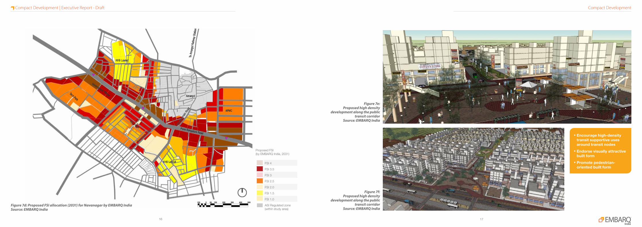
•Encouragehigh-densitytransitsupportiveusesaroundtransitnodes
•Endorsevisuallyattractivebuiltform
•Promotepedestrian-orientedbuiltform
Figure 7e:Proposed high density
development along the public transit corridor
Source: EMBARQ India
Figure 7f:Proposed high density
development along the public transit corridor
Source: EMBARQ IndiaFigure 7d: Proposed FSI allocation (2031) for Navanagar by EMBARQ IndiaSource: EMBARQ India
FSI 4
FSI 3.5
FSI 3
FSI 2.5
FSI 2.0
FSI 1.5
FSI 1.0
ASI Regulated zone (within study area)
Proposed FSI(by EMBARQ India, 2031)
Compact DevelopmentCompact Development | Executive Report - Draft

1918
Pune Bangalore Road
To A
mar
gol R
ailw
ay S
tatio
n
APMC
Amargol
Navanagar
Tech Park
Government Offices
KHB Layout
KHB Layout
Navan
agar
main Roa
d Amar
gol m
ain R
oad
Figure 8a:Landuse generated from zoning regulations proposed by the Revised CDP 2021Source: EMBARQ India
Figure 8b:Existing Scenario:
Dharwad CBTSource: EMBARQ India
•PlotsadjacenttoPBroadhaveauto-orienteduses
•Lineargrowthofcommercialalongmainroadsandlackofmixed-useintheneighbourhoods
Low Density Residential
Medium Density Residential
High Density Residential
Industrial
Com./ Density Addition
Commercial
Public Land Use
Parks & Open Spaces
Lakes
Proposed Landuse 2021(as per revised CDP 2021)
Transit Supportive UsesTransit Supportive Uses | Executive Report - Draft

2120
Pune Bangalore Road
To A
mar
gol R
ailw
ay S
tatio
n
APMC
Amargol
Navanagar
Tech Park
Government Offices
KHB Layout
KHB Layout
Navan
agar
main Roa
d Amar
gol m
ain R
oad
Figure 8d: Proposed land use by EMBARQ IndiaSource: EMBARQ India
•Primarydevelopmentfocuswithcasesensitivelandmix
•Amendmentstozoningregulationstoachievethedesiredmixoflanduse
•Discouragenon-supportivelow-densityuses
•Providediverserangeofhousingtypesanddwellingunitsizes
Figure 8e:Proposed land use
around the bus stopsSource: EMBARQ India
Figure 8f:Proposed land use
around the bus stopsSource: EMBARQ India
Low Density Residential
Medium Density Residential
High Density Residential
Commercial Axis
Commercial
Public Land Use
Parks & Open Spaces
Lakes
Proposed Landuse 2031 (by EMBARQ India)
Transit Supportive UsesTransit Supportive Uses | Executive Report - Draft

2322
Pune Bangalore Road
To A
mar
gol R
ailw
ay S
tatio
n
APMC
Amargol
Navanagar
Tech Park
Government Offices
KHB Layout
KHB Layout
Navan
agar
main Roa
d Amar
gol m
ain R
oad
Figure 9b:Existing 16m wide ROW in NavanagarSource: EMBARQ India
•Incompleteroadstretches•Inconsistentroadwidths•Nointerconnectingnetwork
•Nocleardistributionofroadhierarchiesinexistingnetwork
Figure 9c:Existing section for 16m wide ROW in NavanagarSource: EMBARQ India
Figure 9d:Existing 12m wide ROW in NavanagarSource: EMBARQ India
Figure 9e:Existing section for 12m wide ROW in NavanagarSource: EMBARQ India
Figure 9a: Existing road network in NavanagarSource: EMBARQ India
Study Area Boundary
Plot Boundary
Existing Road Network
Existing Open Area
Existing Water Bodies
Marshy Areas
Existing Road Network (2012)
Complete StreetsComplete Streets | Executive Report - Draft
2524
Pune Bangalore Road
To A
mar
gol R
ailw
ay S
tatio
n
APMC
Amargol
Navanagar
Tech Park
Government Offices
KHB Layout
KHB Layout
Navan
agar
main Roa
d Amar
gol m
ain R
oad
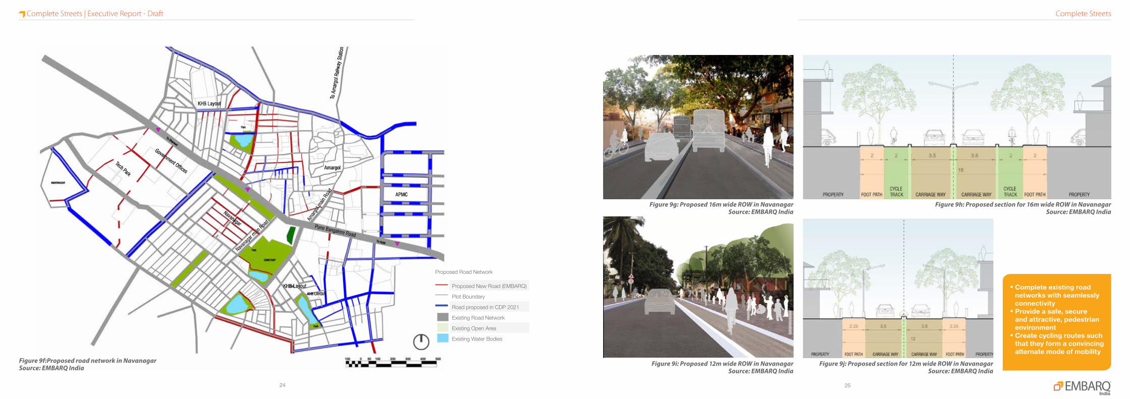
Figure 9g: Proposed 16m wide ROW in NavanagarSource: EMBARQ India
Figure 9h: Proposed section for 16m wide ROW in NavanagarSource: EMBARQ India
Figure 9i: Proposed 12m wide ROW in NavanagarSource: EMBARQ India
Figure 9j: Proposed section for 12m wide ROW in NavanagarSource: EMBARQ India
Figure 9f:Proposed road network in NavanagarSource: EMBARQ India
•Completeexistingroadnetworkswithseamlesslyconnectivity
•Provideasafe,secureandattractive,pedestrianenvironment
•Createcyclingroutessuchthattheyformaconvincingalternatemodeofmobility
Proposed Road Network
Proposed New Road (EMBARQ)
Plot Boundary
Road proposed in CDP 2021
Existing Road Network
Existing Open Area
Existing Water Bodies
Complete StreetsComplete Streets | Executive Report - Draft

2726
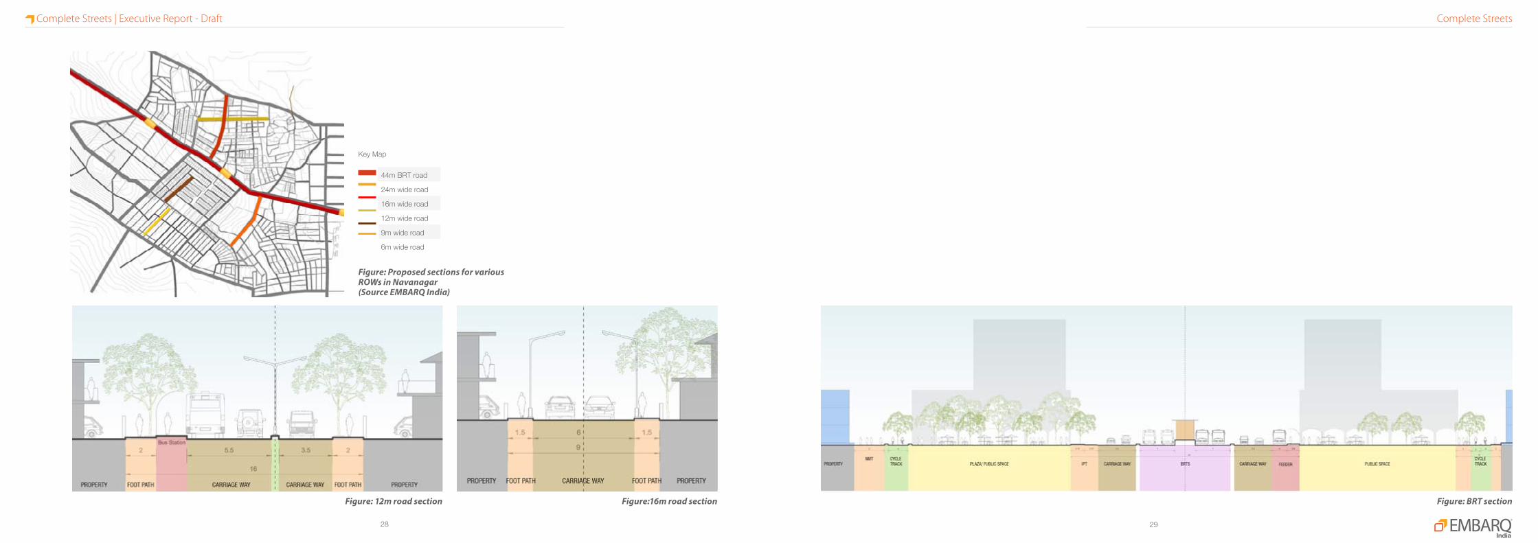
PROPOSED ROAD SECTIONS
Figure: 6m road sectionFigure: 24m road section Figure: 9m road section
Complete StreetsComplete Streets | Executive Report - Draft
2928
Figure: 12m road section Figure:16m road section Figure: BRT section
44m BRT road
24m wide road
16m wide road
12m wide road
9m wide road
6m wide road
Key Map
Figure: Proposed sections for various ROWs in Navanagar(Source EMBARQ India)
Complete StreetsComplete Streets | Executive Report - Draft
3130
Pune Bangalore Road
To A
mar
gol R
ailw
ay S
tatio
n
APMC
Amargol
Navanagar
Tech Park
Government Offices
KHB Layout
KHB Layout
Navan
agar
main Roa
d Amar
gol m
ain R
oad
Figure 10a:Existing public spaces in NavanagarSource: EMBARQ India
Study Area Boundary
Plot Boundary
Road propsed in MP 2021
Contour Lines
Natural Drainage
Existing Open Area
Existing Water Bodies
Riparian Zone-20m
Riparian Zone-40m
Existing Natural Features
•Waterchannelsandnaturaldrainsaredisconnectedduetonewlybuiltupareas
•Parkshavelimitedaccess(ortiming)andaredesolateintheevenings
•Sewerageletintolakes
Left - Figure 10b:Vegetable market
in NavanagarSource: EMBARQ India
Right - Figure 10c:Public park along
PB road in NavanagarSource: EMBARQ India
Figure 10e: Amargol pondSource: EMBARQ India
Public SpacesPublic Spaces | Executive Report - Draft

3332
Pune Bangalore Road
To A
mar
gol R
ailw
ay S
tatio
n
APMC
Amargol
Navanagar
Tech Park
Government Offices
KHB Layout
KHB Layout
Navan
agar
main Roa
d Amar
gol m
ain R
oad
Figure 10f: Proposed public spaces in NavanagarSource: EMBARQ India
Study Area Boundary
Plot Boundary
Road Network
Contour Lines
Natural Valley
Proposed Open Area
Lakes
Proposed Green Spaces•Ecologicallysensitivezonestobepreserved
•Allocateandprovideforatleasttheminimumpublicopenspaceareasrequiredfortheprojectedpopulation
•Designpublicspacesasacontinuationofthepublicrealmsuchthattheyareactive,inviting,safeandsecure
Figure 10g:Proposal for public space
in NavanagarSource: EMBARQ India
Figure 10h:Proposal for public plaza
Source: EMBARQ India
Public SpacesPublic Spaces | Executive Report - Draft
3534
To Dharwad
APMC
Amargol
KHB layout
KHB layout
Cemetery
Government officesTech Park
Navanagar
Navanag
ar Main
Road
To Hubli
Pune Bangalore Road
Amarg
ol main
Road
To A
marg
ol Ra
ilway
Stat
sion
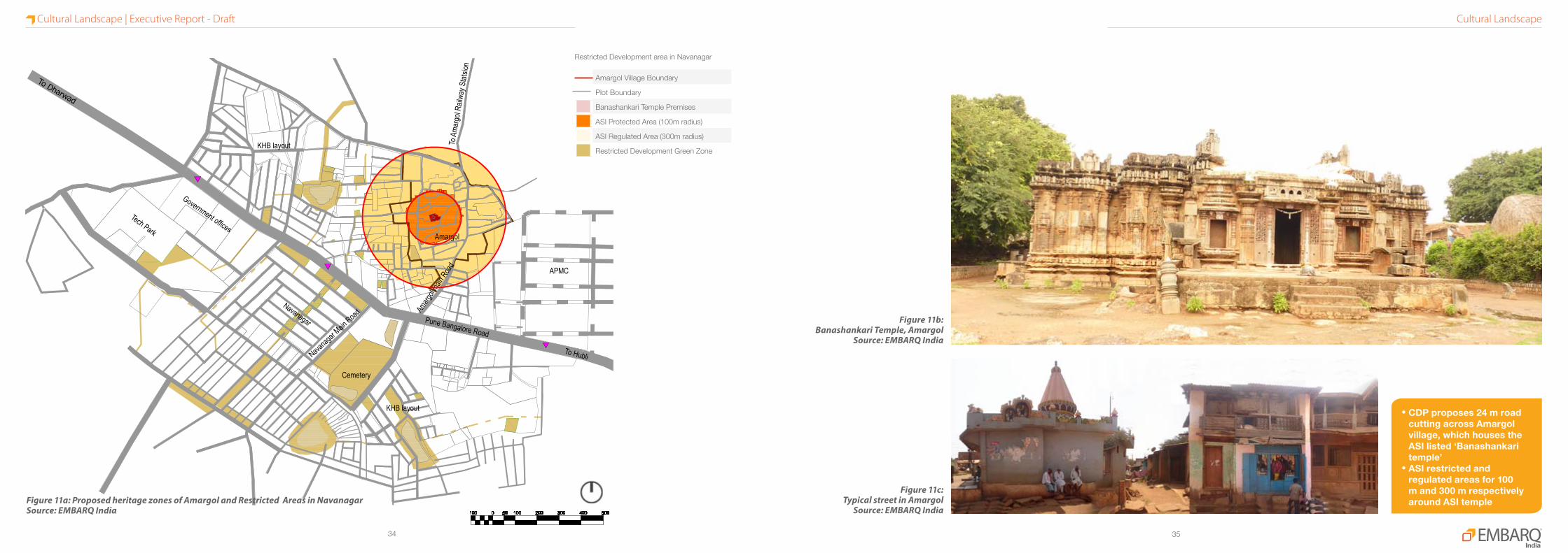
Figure 11b:Banashankari Temple, Amargol
Source: EMBARQ India
Figure 11c:Typical street in Amargol
Source: EMBARQ India
Amargol Village Boundary
Plot Boundary
Banashankari Temple Premises
ASI Protected Area (100m radius)
ASI Regulated Area (300m radius)
Restricted Development Green Zone
Restricted Development area in Navanagar
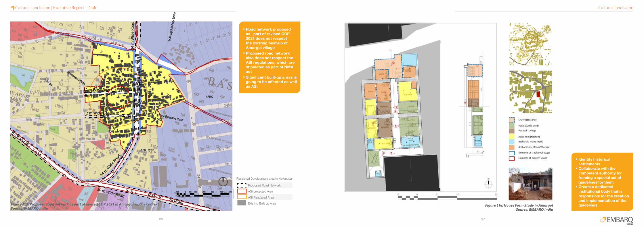
Figure 11a: Proposed heritage zones of Amargol and Restricted Areas in NavanagarSource: EMBARQ India
Cultural LandscapeCultural Landscape | Executive Report - Draft
•CDPproposes24mroadcuttingacrossAmargolvillage,whichhousestheASIlisted‘Banashankaritemple’
•ASIrestrictedandregulatedareasfor100mand300mrespectivelyaroundASItemple
3736
30 m Wide RoadTo Hubli
To Dharwad
12 m Wide Road
12 m Wide Road
24 m
Wid
e Ro
ad
24 m W
ide Road
Figure 11d: Proposed road network as part of revised CDP 2021 in Amargol village context Source: EMBARQ India
•Identifyhistoricalsettlements
•Collaboratewiththecompetentauthorityforframingaspecialsetofguidelinesforthem
•CreateadedicatedinstitutionalbodythatisresponsibleforthecreationandimplementationoftheguidelinesFigure 11e: House Form Study in Amargol
Source: EMBARQ India
Proposed Road Network
ASI protected Area
ASI Regulated Area
Existing Built up Area
Restricted Development area in Navanagar
Pune Bangalore Road
To A
mar
gol R
ailw
ay S
tatio
n
APMC
Amargol
Navanagar
Tech Park
Government Offices
KHB Layout
KHB Layout
Navan
agar
main Roa
d Amar
gol m
ain R
oad
•RoadnetworkproposedaspartofrevisedCDP2021doesnotrespecttheexistingbuilt-upofAmargolvillage
•ProposedroadnetworkalsodoesnotrespecttheASIregulations,whicharestipulatedaspartofNMAact
•Significantbuilt-upareasisgoingtobeaffectedaswellasASI
Cultural LandscapeCultural Landscape | Executive Report - Draft

3938
Figure 12a: Proposed feeder network for NavanagarSource: EMBARQ India
Figure 12b: Rickshaw parking on Navanagar Main RoadSource: EMBARQ India
Promotealternatemodesoftransporttoreduceprivatevehicularuseandcreateparkingmanagementstrategiestoreducespaceoccupiedbyparking.
ZONES FORTRANSPORTSTUDY
Figure 13a: Map showing study zones for travel demand managementSource: EMBARQ India
BRT Corridor
Feeder Roads
Other Roads
11 Study Zone Numbers
Zones for Transport Study
Proposed BRT Corridor
Proposed Feeder Network
Existing Bus Stand
Existing Auto Rickshaw Stand
Pune Bangalore Road
To A
mar
gol R
ailw
ay S
tatio
n
APMC
Amargol
Navanagar
Tech Park
Government Offices
KHB Layout
KHB Layout
Navan
agar
main Roa
d Amar
gol m
ain R
oad
Existing Scenario:
Segregated modes of transit
Eg. Auto stand and bus stop are separated by about 250 m at Navanagar Cancer Hospital
Proposal:
Integrate multiple transit modes at the station area
Create public realm at station area in public transport
Provide public transport feeders from BRT stops/stations
Travel DemandTravel Demand | Executive Report - Draft

4140
CITY LEVEL STRATEGIES1 Revision of Comprehensive
Development Plan• CDP to incorporate principles of TOD• Redefine urban growth boundaries• Classify TOD types and hierarchy of nodes• Prepare local area plans and regulations for major TOD zones• Create overlay zones• Identify and implement demonstration projects
2 Transit Oriented Development Taskforce
• Develop Organizational Framework• Identify agencies and their responsibilities in TOD development (City Agencies + SPV + Advisors)• Facilitate streamlined development approvals• Engage Stakeholders for co-operation /negotiations• Employ Participatory Planning
3 Complete Mobility networks • Prepare NMT network plan for the entire city• Integrate NMT plan with TOD zone development• Integrate multiple modes (BRT, Feeder, IPT, NMT)• Promote travel demand management• Integrate CTTP with NMT, BRT and TOD plans
4 Capacity building • Develop TOD guidelines• Conduct workshops and trainings• Hire capable and qualified personnel at all levels
5 Land Readjustments • Minimize land acquisitions• Maximize town planning schemes• Frame regulations to encourage subdivision and amalgamation
6 Finance Projects • Initiate government’s participation• Investment by public sector agencies• Local tax increment financing• Start trust funds (for initial funding of projects)
7 Investor Incentives • Construction in incentives: density bonus, land assembly, remediation, transit integration, transfer of development rights, reduced parking requirements
• Financial incentives-tax abatement, fee rebate, effective location of loan, PPP/JV (part risk absorption)8 Community incentives • Integration of community facilities in neighbourhood as part of TOD
• Promote local businesses and local skills• Easier loan options and better rates for setting up home/office in TOD• Transfer of development rights• Employer incentives – discounted tickets/passes, shuttle services, docking facilities for cycles
ROLES AND RESPONSIBILITIES OF LINE AGENCIES
Agency Key roles and responsibilities Tools
HDUDA • Regulations for Transit Oriented Development• Develop a comprehensive mobility network• Policies/ guidelines for pedestrian and NMT oriented road design• Guidelines for station area design and multimodal integration• Demarcation of public open spaces, ecologically sensitive zones in the Master Plan• Regulations to minimize surface parking• Provide mixed use as a category in the DCR and land use plan• Provision for Transit-supportive uses in a mobility node
Master PlanCTTPDPRLocal Area PlansTown Planning SchemesDevelopment Regulations
HDMC • Sanctioning for buildings to be based on TOD regulations • Maintenance of mobility network infrastructure• Adopt pedestrian and NMT infrastructure guidelines• Adopt Station Area Design guidelines prepared by HDUDA• Demarcate parking zones and management• Demarcate IPT zones and management• Provide necessary infrastructure for public spaces
DPRStake Holder meetingsTP SchemeAcquisitionFinancial / Construction Incentives
NWKRTC • Assess the feasibility of BRT feeder systems with HDUDA; identify stops and infrastructure requirements for the same
• Manages operations of the BRTS• Manages operations of the Feeder System
CTTPDPR
HDBRTSCL(SPV)
• Implementation of BRTS in Hubli-Dharwad, implementation of TOD demonstration project, overarching co-ordination related to all the urban land transport initiatives within the region
ProposalProposal | Executive Report - Draft
4342
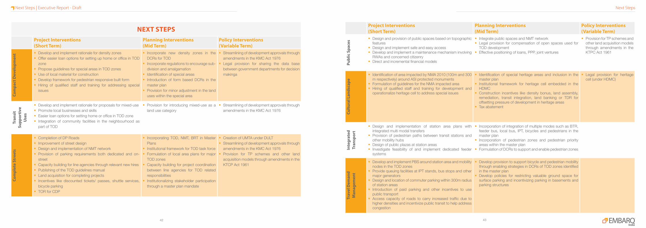
NExT STEPSProject Interventions (Short Term)
Planning Interventions (Mid Term)
Policy Interventions (Variable Term)
Com
pact
Dev
elop
men
t • Develop and implement rationale for density zones• Offer easier loan options for setting up home or office in TOD
zone• Propose guidelines for special areas in TOD zones• Use of local material for construction • Develop framework for pedestrian responsive built form• Hiring of qualified staff and training for addressing special
issues
• Incorporate new density zones in the DCRs for TOD
• Incorporate regulations to encourage sub-division and amalgamation
• Identification of special areas• Introduction of form based DCRs in the
master plan• Provision for minor adjustment in the land
uses within the special area
• Streamlining of development approvals through amendments in the KMC Act 1976
• Legal provision for sharing the data base between government departments for decision makinga
Tran
sit
Supp
orti
ve
Use
s
• Develop and implement rationale for proposals for mixed-use• Promote local businesses and skills• Easier loan options for setting home or office in TOD zone• Integration of community facilities in the neighbourhood as
part of TOD
• Provision for introducing mixed-use as a land use category
• Streamlining of development approvals through amendments in the KMC Act 1976
Com
plet
e St
reet
s
• Completion of DP Roads• Improvement of street design• Design and implementation of NMT network• Provision of parking requirements both dedicated and on-
street• Capacity building for line agencies through relevant new hires• Publishing of the TOD guidelines manual• Land acquisition for completing projects• Incentives like discounted tickets/ passes, shuttle services,
bicycle parking• TOR for CDP
• Incorporating TOD, NMT, BRT in Master Plans
• Institutional framework for TOD task force• Formulation of local area plans for major
TOD zones• Capacity building for project coordination
between line agencies for TOD related responsibilities
• Institutionalizing stakeholder participation through a master plan mandate
• Creation of UMTA under DULT• Streamlining of development approvals through
amendments in the KMC Act 1976• Provision for TP schemes and other land
acquisition models through amendments in the KTCP Act 1961
Project Interventions(Short Term)
Planning Interventions (Mid Term)
Policy Interventions (Variable Term)
Publ
ic S
pace
s • Design and provision of public spaces based on topographic features
• Design and implement safe and easy access• Develop and implement a maintenance mechanism involving
RWAs and concerned citizenry• Direct and incremental financial models
• Integrate public spaces and NMT network• Legal provision for compensation of open spaces used for
TOD development• Effective positioning of loans, PPP, joint ventures
• Provision for TP schemes and other land acquisition models through amendments in the KTPC Act 1961
Cult
ural
Lan
dsca
pe
• Identification of area impacted by NMA 2010 (100m and 300 m respectively) around ASI protected monuments
• Formulation of guidelines for the NMA impacted area• Hiring of qualified staff and training for development and
operationalize heritage cell to address special issues
• Identification of special heritage areas and inclusion in the master plan
• Institutional framework for heritage cell embedded in the HDMC
• Construction incentives like density bonus, land assembly, remediation, transit integration, land banking or TDR for offsetting pressure of development in heritage areas
• Tax abatement
• Legal provision for heritage cell (under HDMC)
Inte
grat
ed
Tran
spor
t
• Design and implementation of station area plans with integrated multi modal transfers
• Provision of pedestrian paths between transit stations and other mobility hubs
• Design of public plazas at station areas• Investigate feasibility of and implement dedicated feeder
systems
• Incorporation of integration of multiple modes such as BTR, feeder bus, local bus, IPT, bicycles and pedestrians in the master plan
• Incorporation of pedestrian zones and pedestrian priority areas within the master plan
• Formulation of DCRs to support and enable pedestrian zones
Trav
el D
eman
d M
anag
emen
t
• Develop and implement PBS around station area and mobility nodes in the TOD zones
• Provide queuing facilities at IPT stands, bus stops and other major generators
• Design and location of commuter parking within 300m radius of station areas
• Introduction of paid parking and other incentives to use public transport
• Access capacity of roads to carry increased traffic due to higher densities and incentivize public transit to help address congestion
• Develop provision to support bicycle and pedestrian mobility through enabling strategies in DCRs of TOD zones identified in the master plan
• Develop policies for restricting valuable ground space for surface parking and incentivizing parking in basements and parking structures
Next StepsNext Steps | Executive Report - Draft
4544
TOD Demonstration Concept ReportSubmit the revised TOD demonstration concept report, “Shaping Hubli-Dharwad as a ‘Connected City’” to DULT after incorporating peer reviews as well as suggestions by various stakeholders on the draft report circulated in April 2013.
This report showcases the means to demonstrate the transit oriented development in Navanagar and the measures to be taken at city and state level for policy and regulatory framework inorder to crate the conducive environment for TOD in entire Hubli-Dharwad.
TOD demonstration reportAu
gust
‘13
Sept
embe
r ‘13
Oct
ober
‘13
Nove
mbe
r ‘13
Dece
mbe
r ‘13
Janu
ary
‘14
Febr
uary
‘14
Mar
ch ‘1
4
April
‘14
Stakeholder consultations
Delineation of parcels and finalisation of projects
Design drawings
Conceptual GFC drawings
Compilation of reviews on draft report
Project kickoff meeting
Stakeholder Meetings
One-on-one discussions with major stakeholders
Finalisation of Projects for TOD DemonstrationStakeholder consultations will be conducted in August & September 2013 in order to finalize TOD demonstration projects in the short and long terms. The projects will be dovetailed with other department proposals wherever possible.
One-on-one discussions with important stakeholders as well as round table discussions with all will be conducted in this process and the roles and responsibilities will then be finalised.
Conceptual Design Drawings for Public Space and Complete StreetsConceptual design drawings will be prepared by EMBARQ India for the finalized projects based on the TOD principles customized to suit the Indian scenario especially the Hubli-Dharwad case.
These drawings will be as per the standards acceptable by major stakeholders especially as followed or prescribed by the implementing agency.
Implementation Tendering for selection of contract, and selection of contractorsInitiation of implementation for Complete Streets and Public Space
Preparation of GFC drawings based on Concept DesignsConceptual design drawings will be prepared for the finalized projects based on which GFC drawings will be prepared by consultants to implement the projects in Navanagar.
These projects acts as TOD demonstration projects for taking up the develop-ment in similar lines around BRT station along BRT corridor in Hubli-Dharwad.
Project ScheduleProject Schedule | Executive Report - Draft

EMBARQ India# 156, 1st Floor, 3rd Cross1st Block, JayanagarBangalore-560011www.embarqindia.org


