Page 1
Exhumation and incision history of the Lahul Himalaya, northern India, basedon (U-Th)/He thermochronometry and terrestrial cosmogenic nuclide methods
Byron Adams, Craig Dietsch, Lewis A. Owen, Marc W. Caffee, JamesSpotila, William C. Haneberg
PII: S0169-555X(08)00553-9DOI: doi: 10.1016/j.geomorph.2008.12.017Reference: GEOMOR 2843
To appear in: Geomorphology
Received date: 12 September 2008Revised date: 19 December 2008Accepted date: 22 December 2008
Please cite this article as: Adams, Byron, Dietsch, Craig, Owen, Lewis A., Caffee, MarcW., Spotila, James, Haneberg, William C., Exhumation and incision history of the LahulHimalaya, northern India, based on (U-Th)/He thermochronometry and terrestrial cos-mogenic nuclide methods, Geomorphology (2009), doi: 10.1016/j.geomorph.2008.12.017
This is a PDF file of an unedited manuscript that has been accepted for publication.As a service to our customers we are providing this early version of the manuscript.The manuscript will undergo copyediting, typesetting, and review of the resulting proofbefore it is published in its final form. Please note that during the production processerrors may be discovered which could affect the content, and all legal disclaimers thatapply to the journal pertain.
Page 2
ACC
EPTE
D M
ANU
SCR
IPT
ACCEPTED MANUSCRIPT
Exhumation and incision history of the Lahul Himalaya, northern India, 1 based on (U-Th)/He thermochronometry and terrestrial cosmogenic nuclide 2
methods 3 4
Byron Adamsa, Craig Dietscha*, Lewis A. Owena, Marc W. Caffeeb, 5
James Spotilac, William C. Hanebergd 6
7
a Department of Geology, University of Cincinnati, P.O. Box 0013, Cincinnati, OH 45221-0013, U.S.A. 8 b Dept of Physics/PRIME Laboratory, Purdue University, West Lafayette, IN 47906, USA 9
c Department of Geosciences, Virginia Tech, Blacksburg, VA 24061, USA 10
d Haneberg Geoscience, 10208 39th Avenue SW, Seattle WA 98146, USA 11
12 Corresponding author: 13 Craig Dietsch 14 telephone 513.556.2547 15 FAX 513.556.6931 16 [email protected] 17 18 19 Abstract 20 21
Low-temperature apatite (U-Th)/He (AHe) thermochronology on vertical transects of 22
leucogranite stocks and 10Be terrestrial cosmogenic nuclide (TNC) surface exposure dating on 23
strath terraces in the Lahul Himalaya provide a first approximation of long-term (104 - 106 years) 24
exhumation rates for the High Himalayan Crystalline Sequence (HHCS) for northern India. The 25
AHe ages show that exhumation of the HHCS in Lahul from shallow crustal levels to the surface 26
was ∼ 1-2 mm/a and occurred during the past ∼ 2.5 Ma. Bedrock exhumation in Lahul fits into a 27
regional pattern in the HHCS of low-temperature thermochronometers yielding Plio-Pleistocene 28
ages. Surface exposure ages of strath terraces along the Chandra River range from ∼ 3.5 to 0.2 29
Page 3
ACC
EPTE
D M
ANU
SCR
IPT
ACCEPTED MANUSCRIPT
ka. Two sites along the Chandra River show a correlation between TCN age and height above 30
the river level yielding maximum incision rates of 12 and 5.5 mm/a. Comparison of our AHe 31
and surface exposure ages from Lahul with thermochronometry data from the fastest uplifting 32
region at the western end of the Himalaya, the Nanga Parbat syntaxis, illustrates that there are 33
contrasting regions in the High Himalaya where longer term (105 – 107 years) erosion and 34
exhumation of bedrock substantially differ even though Holocene rates of fluvial incision are 35
comparable. These data imply that the orogen’s indenting corners are regions where focused 36
denudation has been stable since the mid-Pliocene. However, away from these localized areas 37
where there is a potent coupling of tectonic and surface processes that produce rapid uplift and 38
denudation, Plio-Pleistocene erosion and exhumation can be characterized by disequilibrium, 39
where longer term rates are relatively slower and shorter term fluvial erosion is highly variable 40
over time and distance. The surface exposure age data reflect differential incision along the 41
length of the Chandra River over millennial time frames, illustrate the variances that are possible 42
in Himalayan river incision, and highlight the complexity of Himalayan environments. 43
44 45 Keywords: Himalaya; strath terraces; terrestrial cosmogenic nuclides; AHe thermochronology; 46 exhumation; fluvial incision; Lahul 47 48 49 50 1. Introduction 51 52
Processes at convergent plate boundaries that build topography are widely understood to 53
be episodic on timescales of 106-107 years (for example, Lamb et al., 1997; Lister et al., 2001; 54
Quarles van Ufford and Cloos, 2004). Transient landscapes, too, can persist on time scales of 55
106 years (Kirby et al., 2002; Clark et al., 2006; Riihimaki, 2007). How erosion responds to 56
changes in uplift, whether erosion rates vary with time, and whether mountain landscapes are 57
Page 4
ACC
EPTE
D M
ANU
SCR
IPT
ACCEPTED MANUSCRIPT
transient or can achieve steady-state conditions remain important questions in geomorphology. 58
Key processes in addressing these issues are exhumation and erosion. The rates of these 59
processes constrain the interplay and relative roles of tectonic vs. surficial geologic processes in 60
mountain belts. 61
62 The Himalayan orogen is an archetype natural laboratory for the study of exhumation and 63
erosion because it is tectonically active and characterized by extreme relief (relative relief can 64
exceed 3000 m), large-scale mass wasting (large avalanches, debris flows, and rock falls), and 65
glacial landforms (over steepened valleys, moraines, and glacial dam bursts). Exhumation rates 66
of the northern Indian Himalaya have not been well defined in spite of their significance for 67
surficial and tectonic dynamics. To further understand the timing and rates of exhumation and 68
erosion in the Lahul region of the Greater Himalaya, we have obtained quantitative data using 69
(U-Th)/He apatite (AHe) thermochronology and terrestrial cosmogenic nuclide (TCN) methods. 70
71 Lahul is located approximately midway between the Indo-Gangetic Plain and Tibet (Fig. 72
1) in the Pir Panjal and Greater Himalaya of northern India. Lahul is an impressive, rugged 73
landscape comprising U-shaped valleys, mountain sides and peaks underlain by massively 74
jointed faces of granite, large granite and meta-sedimentary debris deposits, and smaller fluvial 75
and glacial landforms. 76
77 Several general aspects of the exhumation history of the Lahul Himalaya are well 78
characterized. These are derived from studies of regional deformation and faulting (Steck et al., 79
1993; Vannay and Steck, 1995; Wyss and Steck, 1999), chronology of emplacement of igneous 80
rocks and regional metamorphism (Searle and Fryer, 1986; Walker et al., 1999), and geomorphic 81
evolution (Owen et al., 1995, 1997, 2001). Some specific aspects of erosion in Lahul have been 82
Page 5
ACC
EPTE
D M
ANU
SCR
IPT
ACCEPTED MANUSCRIPT
studied, including catastrophic flooding (Coxon et al., 1996), glaciation, and paraglaciation 83
(Owen et al., 1995). However, results from these studies are too spatially or temporally narrow 84
to define regional exhumation or erosion rates. Moreover, longer-term exhumation and erosion 85
rates, on timescales of 105-107 years, are lacking from Lahul. Recent thermochronologic studies 86
elsewhere in the Himalaya have defined exhumation rates of 3-7 mm/a at time scales of 106 years 87
(Harrison et al., 1997; Zeitler et al., 2001). Fission track (FT) data have revealed that significant 88
erosion occurred in the Pakistan Karakoram during the Pliocene. Foster et al. (1994) proposed 89
that at least 7000 m of rock were eroded during this period, yielding exhumation rates of 3-6 90
mm/a. 91
92 To build on these studies, we employed low-temperature AHe thermochronology on 93
vertical transects of leucogranite stocks and 10Be terrestrial cosmogenic nuclide (TCN) surface 94
exposure dating (SED) on strath terraces exposed along the Chandra River and one of its 95
tributaries. Our primary goals in using AHe thermochronology in Lahul were first, to determine 96
whether long-term (106 years) exhumation rates could be established, and second, to gather data 97
bearing on whether the topographic and thermal structure of Lahul have reached steady-state. 98
Changes in erosion rate and the rate at which topography develops can significantly affect the 99
migration and geometry of isotherms and can disturb cooling ages at the surface (Braun et al., 100
2006, p.105-176). TNC methods can quantify surface processes at millennial timescales back to 101
20-30 ka, and our goal of dating strath terraces was to determine recent river incision rates. Any 102
spatial and temporal variation in surface exposure ages of strath terraces along the Chandra will 103
provide a gauge of the heterogeneity of fluvial bedrock incision in this active Himalayan 104
environment. 105
Page 6
ACC
EPTE
D M
ANU
SCR
IPT
ACCEPTED MANUSCRIPT
Our data can be used to test whether the Lahul Himalaya has undergone rapid 106
exhumation. i.e. 3-7 mm/a, as proposed for elsewhere in the orogen and to determine whether 107
local river incision rates are as high as other regions of the Himalaya, of the order of 1 to 20 108
mm/a, where more is known about uplift and erosion histories (Burbank et al., 1996). The timing 109
of low-temperature cooling and the fluvial incision of the High Himalayan Crystalline Sequence 110
(HHCS) in Lahul further bears on the linkage between local topography, regional rock 111
deformation and strain partitioning, and surface erosion. 112
113 2. Background 114 115
Two main NW-SE-trending mountain ranges traverse Lahul, the Pir Panjal to the south 116
and the Greater Himalaya to the north (Fig. 1). Both ranges include peaks exceeding 6000 m in 117
elevation above sea level (asl; the highest peak in Lahul is Mulkila at 6520 m asl) and valley 118
floors occur at elevations ≤ 3000 m asl. 119
120 2.1 Tectonic setting 121 122
Traversing Lahul is part of the HHCS (Vannay and Steck, 1995), the crystalline core of 123
the orogen where mountain peaks along its entire length through the orogen are typically in 124
excess of 6000 m asl. The HHCS in Lahul is composed of Precambrian and Paleozoic 125
metamorphic rocks intruded by large stocks and sills of porphyritic K-feldspar granite of 126
Cambrian-Ordovician age (Frank et al., 1973; Miller et al., 2001) and leucogranite of Miocene 127
age (Fig. 2; Searle and Fryer, 1986; Searle, 1991; Walker et al., 1999; Webb et al., 2007). 128
Crustal thickening in Lahul has been viewed as occurring during emplacement of southwest-129
verging nappes during the late Eocene to early Oligocene, and again during the late Oligocene 130
and early Miocene coincident with movement along the northwest-dipping Main Central thrust 131
Page 7
ACC
EPTE
D M
ANU
SCR
IPT
ACCEPTED MANUSCRIPT
(MCT; Vannay and Steck, 1995). Nappe emplacement produced regional Barrovian 132
metamorphism, dated in northwest Lahul by U-Pb ages of monazite at 29-31 Ma (Walker et al., 133
1999). Partial melting of metasediments during upper amphibolite facies metamorphism 134
produced stocks and plugs, and lit-par-lit intrusion of leucogranite, resulting in widespread 135
stromatic migmatitic layering within the metasedimentary bedrock of Lahul (Searle and Fryer, 136
1986). From leucogranites in Lahul, Walker et al. (1999) reported U-Pb ages of monazite, 137
xenotime, and uraninite which together gave an age of 21 Ma; Searle and Fryer (1986) reported a 138
muscovite Rb-Sr age of 17.6 Ma; and Vannay and Steck (1995) reported an 40Ar/39Ar age of 139
biotite of 16 Ma, all of which record Miocene crystallization and cooling. Along-strike east of 140
Lahul, U-Pb zircon ages of leucogranite that intrudes the HHCS are early Miocene (22-23 Ma) 141
and middle Miocene (12-13 Ma; summarized by Hodges, 2000). 142
143 Webb et al. (2007) recently mapped the bedrock within Lahul, including our study area 144
showing that rocks of the HHCS are in contact with the Tethyan Himalayan Sequence along the 145
South Tibetan Detachment (STD; Fig. 2), and proposed that movement along the STD was 146
south- and north-verging. Hodges (2006) placed the structural evolution of the HHCS in the 147
context of the hypothesis of channel flow. 148
149 2.2 Fluvial landscape setting 150 151
Lahul lies in the transition zone between the lush monsoonal climate on the southern 152
flanks of the Pir Panjal and the semi-arid Zanskar and Ladakh ranges of the Trans-Himalaya to 153
the north (Fig. 3). Lahul presently receives some precipitation during the South Asian Monsoon 154
(SAM; Benn and Owen, 1998), although this amount has not been quantified since spatial 155
coverage of meteorological data collection stations is lacking. The annual precipitation in the 156
Page 8
ACC
EPTE
D M
ANU
SCR
IPT
ACCEPTED MANUSCRIPT
semi-arid environment of Lahul is considerably less than that in the Lesser Himalaya due to 157
orographic effects. 158
159 The Chandra and Bhaga Rivers are the principal drainages of this region and they have 160
many smaller tributary streams originating from the surrounding steep mountainsides (Fig. 1). 161
Within the study region, the Chandra River’s stream order is a 3 on the Strahler scale as derived 162
from a 1:250,000 scale map. The Chandra River flows down large and wide glaciated valleys 163
that change direction nearly 180° from a SSE flow at the headwaters near Baralacha La to a 164
range-parallel NW flow near Koksar, suggesting that the northern reaches of the Chandra Valley 165
is antecedent while the southern portion follows topography or geologic strike. The majority of 166
the valleys in Lahul are glaciated and U-shaped with broad floors, steep sides, and propagating 167
debris fans. The combination of these glaciated valleys produces dramatic horns and arêtes 168
throughout the region. 169
170
Owen et al. (1995) described the drainage system of Lahul, showing that the Lahul fluvial 171
regime is dominated by glacial meltwater dynamics, producing large diurnal and seasonal 172
fluctuations in discharge. Superimposed on this varying flow regime are the effects of low-173
frequency, high-magnitude storm flows created by occasional penetration of monsoonal airflows. 174
The distinct daily discharges reflect diurnal temperature cycles, lagging by 3 to 5 hours. A 175
gauging station was active during September 1993 measuring the discharge of the Chandra River 176
at Batal. Measured discharge and stream power were 12.8 m3/s and 3287 W/m, respectively. 177
Stream power per unit width was 142.9 W/m2, indicating a high bedload capacity even at low 178
flow, non-monsoon conditions. A gauging station was also set up in a smaller tributary directly 179
to the east of Batal, the Kharcha Valley, during September 1993. Data collected in the Kharcha 180
Page 9
ACC
EPTE
D M
ANU
SCR
IPT
ACCEPTED MANUSCRIPT
Valley show insignificant bedload transport between high magnitude monsoon storm events and 181
the beds are clearly armored during this time. However, the data gathered at these stations are 182
limited, as only one month was recorded. 183
184 Lahul is similar to other regions of the Himalaya in that its river systems yield very high 185
sediment loads (Owen et al., 1995). Sediment transfer is episodic and dictated by seasonal 186
cycles, the magnitude of monsoon storm events, and the dynamics of highly active slope 187
processes (Owen et al., 1995). The Chandra oscillates from low width, single channel conditions 188
to wide, multi-channel braided sandur (glacial outwash plain) reaches along its length. Large 189
sandurs occur in valley reaches of low gradient (2-15°). There are sandurs found in the upper 190
Chandra Valley upstream from Batal and in the upper Kulti Valley. Large alluvial fans are 191
present in Lahul with gradients of 2-10° reflecting high rates of deposition from glaciofluvial 192
rivers. There are also fans dominated by debris flows. Exposed sections of fans exhibit 193
interbedded sands, gravels, diamictons, and boulder layers. The presence of fan terraces implies 194
distinct episodes of aggradation and incision (Owen et al., 1995). 195
196
2.3 Glacial landscape setting 197
198 Abundant glacial landforms show that Lahul has been extensively glaciated. Owen et al. 199
(2001) recognized five late Quaternary glacial stages in Lahul: the Chandra and Batal glacial 200
stages characterized by major valley glaciations, when glaciers occupied the main Chandra trunk 201
valley; the Kulti glacial stage where glaciers occupied tributary valleys and in some cases, may 202
have extended partially into the larger trunk valley; and the Sonapani I and II glacial stages 203
represented by limited glacier advances with glaciers restricted to tributary valleys. The Batal 204
Page 10
ACC
EPTE
D M
ANU
SCR
IPT
ACCEPTED MANUSCRIPT
and Kulti glacial stages have been dated by TCN surface exposure dating methods to 12-15.5 ka 205
and 10–11.4 ka, respectively. The oldest and largest of the inferred glacial events, the Chandra 206
glacial stage, produced bedrock benches and eroded drumlins at elevations > 4300 m asl (~ 1200 207
m above the present valley floor). Owen et al. (2001) suggest that all the Lahul glacial advances 208
were strongly influenced by increased precipitation, as snow, during insolation maxima that 209
enhanced monsoon activity in the region. 210
211
The recorded glacial events and subsequent fluvial drainage have removed large amounts 212
of host meta-sedimentary rock and leucogranite from Lahul. It is possible that there were much 213
older and more extensive periods of glaciation in this region prior to the Late Quaternary as 214
Northern Hemisphere glaciation intensified at approximately 2.7 Ma (Clemens and Tiedemann, 215
1997). There is also evidence of glaciation older than 430 ka in the Ladakh Himalaya (~ 250 km 216
north of Lahul; Owen et al., 2006) and glaciers were probably present in the Karakoram of 217
Northern Pakistan since 720 ka (Cronin and Johnson, 1988). In Lahul, however, it is unlikely 218
that evidence for these older glaciations is preserved in this very geomorphically dynamic 219
landscape. 220
221
3. Methods 222
3.1 Field mapping 223
224 We use the mapping of Searle and Fryer (1986), Vannay and Steck (1995), Owen et al. 225
(1995, 1997, 2001) and Webb et al. (2007) as a basis for our sample collection. The mapping 226
was supplemented by detailed geomorphic, petrological and structural descriptions at study sites 227
Page 11
ACC
EPTE
D M
ANU
SCR
IPT
ACCEPTED MANUSCRIPT
throughout our research area. Surveys of strath terraces were undertaken using a hand-held laser 228
distance finder, an inclinometer, and a 30 m measuring tape. 229
230
3.2 DEM analysis 231
232 The best publicly available topographic data for the region consist of on-demand ASTER 233
(Advanced Spaceborne Thermal Emission and Reflectance) satellite digital elevation models 234
(DEMs) with 30 m cell size. Experience shows that the smallest landforms that can be identified 235
and mapped on a DEM have characteristic lengths approximately an order of magnitude larger 236
than the DEM cell size. Thus, a 30 m ASTER DEM is sufficient to identify landforms with 237
lengths on the order of 300 m or more. This is too coarse for geomorphic mapping of all but very 238
large landforms, but does provide a useful topographic framework for our work. 239
240
We obtained an ASTER DEM tile covering most of the project area and used it to extract 241
topographic profiles at approximately equal intervals and nearly perpendicular to the Chandra 242
River valley. Each profile was about 10 km long. Both the DEM (shown as a shaded relief 243
image) and the profiles are shown in Fig. 4. We also created a series of standard topographic 244
derivative maps including, for example, slope angle, aspect, roughness, curvature, but we did not 245
find them useful for geomorphic interpretation at a scale commensurate with our study. 246
247
3.3. Sampling for AHe thermochronology 248
249 Ten samples were collected for AHe thermochronology from pl+qtz+kfs+ms±bt±tur±grt 250
leucogranite in two tributary valleys of the Chandra River valley (the Hamptah and Chattru 251
Page 12
ACC
EPTE
D M
ANU
SCR
IPT
ACCEPTED MANUSCRIPT
valleys) and from the Rohtang Pass that leads over the Pir Panjal northwards into the Chandra 252
Valley. Sample locations and detailed descriptions of the rocks we collected are listed in Table 1 253
and shown in Fig. 5. The samples span elevations between about 3100 and 4000 m asl and cover 254
two vertical transects; Fig. 6 illustrates the landscape from which we collected our AHe samples. 255
256
In the Hamptah Valley (on the south side of the Chandra valley; Fig. 6D), and the Chattru 257
Valley (north side of the Chandra; Fig. 6B) we sampled a stock of tourmaline- and garnet-258
bearing leucogranite. Bedrock in the Hamptah and Chattru valleys is dominated by deformed 259
greenschist facies meta-siltstone intruded by sills, dikes, and the stock of leucogranite; some 260
dikes are pegmatitic and some aplitic. 261
262
On the Rohtang Pass (Fig. 6A), a major drainage divide with the Chandra River to the 263
north and the Beas River to the south, we sampled leucogranite from road cut exposures that 264
extend from just north of the pass to Koksar along the Chandra River. Exposed bedrock on the 265
pass is characterized by upper greenschist and lower amphibolite facies metasediments intruded 266
by leucogranite sills. 267
268
3.4. Sampling for 10Be TCN SED 269
270 Fifteen samples for 10Be TCN surface exposure dating were collected from four strath 271
terraces along the Chandra River between Chattru and Koksar to define downstream variations in 272
incision, and one strath terrace along a tributary stream near its intersection with the Chandra 273
(Figs. 5, 7). At each strath terrace site, two to four quartz-rich samples (leucogranite, meta-274
Page 13
ACC
EPTE
D M
ANU
SCR
IPT
ACCEPTED MANUSCRIPT
siltstone, or vein quartz) were collected from the different horizontal strath terrace surfaces (one 275
per level). Details of the TCN samples we collected are given in Table 2. 276
277
The Chandra River has diurnal, seasonal and yearly fluctuations. At any given time, the 278
“current river level” is highly dependent on the amount of glacier/snow melt, south Asian 279
monsoon intensity, and drainage system lag time. During the summer when our samples were 280
collected, the Chandra fluctuated by ~1 m, related to precipitation and time of day. The lowest 281
and most constant flow conditions mostly likely occur in the winter months when there is less 282
snow and glacial melt water. Our samples were collected at an elevated river stage. The ∼1 m 283
variation in river height contributes between about 5–10% error in the height measurement. 284
285
Sampling sites were chosen based on terrace surface morphology and characteristics. 286
Specific locations to collect samples were selected on nearly horizontal surfaces of larger treads 287
and terraces exhibiting polish, potholes, and small sinuous channels were preferentially sampled 288
(Figs. 7C, 7E), as these treads have experienced less subsequent erosion since abandonment than 289
flat, featureless treads. Terraces that showed weathering features, including rough surfaces, deep 290
weathering pitting and exfoliation, were not sampled, nor were strath terraces that had any 291
sediment cover. 292
293
The Chandra River has low-width single channel reaches where strath terraces are present 294
(Fig. 7B). All sampled terraces are unpaired and were debris-free. Samples collected on both 295
the north and south sides of the river. Across from the sampled strath terraces, the banks of the 296
Chandra are debris-covered slopes. It is possible that all of these terraces were formed in paired 297
Page 14
ACC
EPTE
D M
ANU
SCR
IPT
ACCEPTED MANUSCRIPT
successions, and since abandonment, one side of the valley has experienced mass wasting events 298
that have obscured the adjacent set of terraces. Though these debris covers have not been dated, 299
their presence indicates that they are long-lived relative to the geomorphic timescale (102 – 106 300
years) and not easily cleared, and implies that there should be evidence of debris cover on strath 301
terrace surfaces if they were once covered. An effective mechanism to clear a bedrock terrace 302
surface perched 10 m or higher above river level would be a catastrophic flooding event. Flood 303
deposits along the Chandra (Coxon et al., 1996) are overlain by contemporary fan deposits. 304
305
3.5. AHe thermochronology 306
307 The low-temperature AHe thermochronometer allows recent exhumation of rocks to be 308
quantified in terms of cooling histories, typically on million-year timescales. (U-Th)/He dating 309
is based on the radiogenic production and thermally-controlled diffusion of 4He within host 310
minerals. Studies of 4He diffusion in apatite show that helium begins to be quantitatively 311
retained at ∼ 80°C (Zeitler et al., 1987; Wolf et al., 1996; Farley, 2000). Apparent AHe cooling 312
ages commonly correspond to effective closure temperatures of ∼ 70°C, but may range from 80 313
to 40°C depending principally on grain size and cooling rate (Dodson, 1973; Farley, 2000; 314
Ehlers and Farley, 2003; Reiners and Brandon, 2006). 315
316
Apatite grains were separated and loaded into platinum tubes by standard mineral 317
separation techniques in the University of Cincinnati Heavy Mineral Laboratory. Apatite grains 318
≥70 µm in diameter and were screened for micro-inclusions and other crystal defects at 100x 319
magnification. Multigrain AHe ages were measured at Virginia Tech on ~0.01-0.17 mg aliquots 320
(Table 1). To counter the potential effect of U- and Th-bearing micro-inclusions (i.e. zircon and 321
Page 15
ACC
EPTE
D M
ANU
SCR
IPT
ACCEPTED MANUSCRIPT
monazite (House et al., 1997)), fluid inclusions, or parent nuclide zonation on measured ages 322
(Fitzgerald et al., 2006), we analyzed multiple (~ 4) replicates per sample (a total of 38 analyses 323
for 10 samples). This enabled evaluation of sample reproducibility and identification of 324
anomalously old outliers that probably have 4He contamination. Samples were outgassed in a 325
resistance furnace at 940˚C for 20 minutes (followed by a 20-minute re-extraction test) and 326
analyzed for 4He by isotope dilution utilizing a 3He spike and quadrupole mass spectrometry. 327
Blank level for 4He detection was ~ 0.2 femtomoles. Radiogenic parent isotopes (238U, 235U, and 328
232Th) were measured at Caltech using isotope dilution (235U and 230Th spike) and ICP mass 329
spectrometry. Although 4He is also produced by 147Sm decay, it is not routinely measured 330
because it should produce < 1% of radiogenic 4He in typical apatite and should only be a factor 331
in AHe ages when U concentrations are low (Farley and Stockli, 2002; Reiners and Nicolescu, in 332
press). 333
334
Routine 1σ uncertainties due to instrument precision are +1-2% for U and Th content, 335
+2-3% for He content, and +4-5% for alpha ejection correction factor based on grain dimension 336
and shape. Cumulative analytical uncertainty is thus approximately ±10% (2σ). Age accuracy 337
was cross-checked by measurements of known standards, principally Durango fluorapatite 338
(30.9±1.53 Ma (1σ; n=40)), with a known age of 31.4 Ma (McDowell et al., 2005). These 339
measurements on Durango show that reproducibility on some natural samples is comparable to 340
that expected from analytical errors. Uncertainties for samples are reported as the observed 341
standard deviation from the mean of individual age determinations (Table 1). Average AHe 342
reproducibility on average ages in this study is ~ 14% (1σ), which is somewhat worse than that 343
obtained from Durango apatite and indicative of poor apatite quality. 344
Page 16
ACC
EPTE
D M
ANU
SCR
IPT
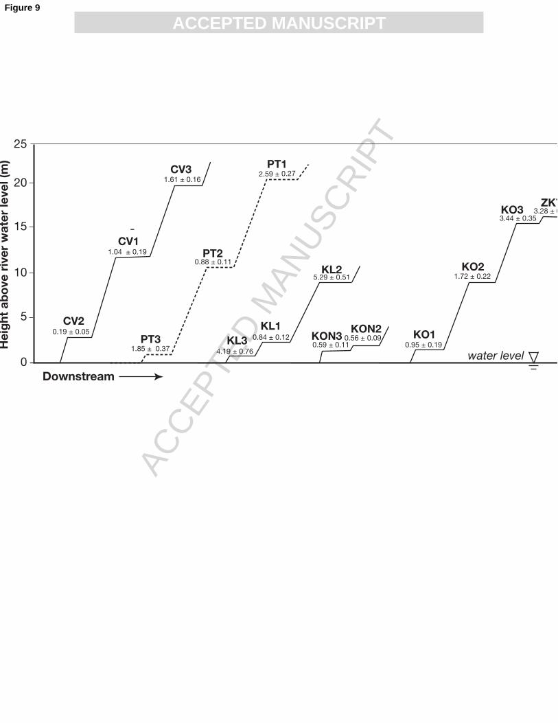
ACCEPTED MANUSCRIPT
345
3.6. Surface exposure dating 346
347 The strath terrace samples were prepared in the University of Cincinnati Terrestrial 348
Cosmogenic Nuclide Laboratory following precisely the same procedures presented in detail by 349
Dortch et al. (2008). Measurement of 10Be/9Be ratios by accelerator mass spectrometry was 350
undertaken at the PRIME Laboratory at Purdue University. 351
352 All 10Be ages for rock samples were calculated using the CRONUS calculator 353
(http://hess.ess.washington.edu/math/; Balco et al., 2008; Table 2). This uses the scaling factors 354
of Stone (2000) and a sea-level low-latitude production rate of 4.98 10Be atoms/gram of 355
quartz/year. Uncertainty associated with the different scaling models used to calculate the TCN 356
ages for this region may result in ages of up to 20% older than ages calculated using the Lal 357
(1991)/Stone (2002) time-independent modeling scheme (for more discussion see Owen et al., 358
2008). Accordingly, our ages can be considered as minimum values and our incision rates as 359
maximum values. In addition, no correction was made for geomagnetic field variations due to 360
the ongoing debate regarding which correction factors are most appropriate. Geomagnetic 361
corrections on our 10Be ages can change the age by up to 16%, but most ages change by < 10%. 362
Furthermore, we have not made any corrections for erosion. However, assuming that all the 363
strath terrace surfaces that were sampled weather at a moderate rate of 5 m/Ma, a calculated age 364
of 10 ka assuming zero terrace erosion would underestimate the true age by a maximum of 4%; 365
an age of 20 ka by 9%; an age of 40 ka by 20% (Owen et al., 2002). 366
367
4. Results 368
Page 17
ACC
EPTE
D M
ANU
SCR
IPT
ACCEPTED MANUSCRIPT
369 4.1 Digital Terrain Modeling 370
371 Although we did not find the DEM or derivative products (e.g., slope angle, aspect, 372
roughness, or curvature maps) useful for detailed geomorphic mapping in the project area, it did 373
yield topographic profiles showing four terrace levels that can be correlated from profile to 374
profile (Fig. 4). These terraces lie at elevations of approximately 4800 m, 4425 m, 3650 m, and 375
3450 m asl. The four terrace levels were identified on the westernmost profile (A-A’), where the 376
river is most deeply incised, and then drawn across the upstream profiles for comparison. 377
Profiles D-D’, E-E’, and F-F’ contain several distinct terraces that are close, but distinctly 378
different than, the elevations projected from profile A-A’. They are shown with a query in Fig. 379
4. 380
381
Because most of the queried terraces are slightly below the terrace elevations projected 382
from profile A-A’, it is unlikely that they reflect upstream elevation increases along the stream 383
gradient. They may, however, indicate tectonic activity such as greater uplift or warping along 384
more deeply incised portions of the valley, or terrace levels not apparent in the other profiles. At 385
present, we are unable to distinguish between those two possibilities. Topographic anomalies 386
along the north side of the Chandra valley in the vicinity of profiles C-C’, D-D’, and F-F’, which 387
are visible on both the shaded relief image and the profiles, appear to represent a complex of 388
large scale landslides and alluvial fans. 389
390
4.2 AHe data 391
392
Page 18
ACC
EPTE
D M
ANU
SCR
IPT
ACCEPTED MANUSCRIPT
AHe ages from five leucogranite samples in the Hamptah Valley are Plio-Pleistocene 393
(Fig. 8): 1.39±0.04 to 2.51±0.29 Ma. Replicate analyses from these samples reproduced fairly 394
well, although each sample yielded one outlier that was significantly different from the mean 395
(Table 1). The outliers for samples HA1, HA2, HA4, and HA5b are anomalously older than 396
average AHe age and are probably due to the presence of undetected U- and/or Th-bearing 397
micro-inclusions, as has been observed elsewhere (e.g. House et al., 1997). In these samples, the 398
outliers were culled prior to the calculation of mean age. The outlier for sample HA4b was 399
culled from the data on the basis of low U content and low He yield, similar to several samples 400
from Rohtang Pass (see below). Curiously, average AHe ages from the Hamptah Valley (Fig. 8) 401
do not show a positive correlation between age and elevation. 402
403
AHe ages from Rohtang Pass and Chattru Valley reproduced more poorly than those 404
from Hamptah Valley, but average ages span a similar Plio-Pleistocene range (Fig. 8): 1.37±0.23 405
to 3.17±0.71 Ma. The poor reproducibility of these samples is probably attributable to low U 406
contents. Of nineteen individual analyses, ten produced U concentrations less than 3 ppm. 407
Multi-grain AHe ages in samples with such low U contents are susceptible to inaccuracies 408
associated with parent nuclide zonation or U- and/or Th-bearing microinclusions, given that 4He 409
from a small U or Th contamination or spatially heterogeneous ingrown 4He can be a significant 410
contribution to the total helium in an aliquot (House et al., 1997; Farley and Stockli, 2002; 411
Fitzgerald et al., 2006; Reiners and Nicolescu, in press.). Helium produced by the decay of 412
147Sm may also be relatively significant in such low U samples (Farley and Stockli, 2002). 413
Given that we did not measure 147Sm on the initial runs of these reconnaissance samples, the 414
individual ages for low U samples could thus be too old if 147Sm concentrations were higher than 415
Page 19
ACC
EPTE
D M
ANU
SCR
IPT
ACCEPTED MANUSCRIPT
several hundred ppm (Reiners and Nicolescu, in review). An additional complication of low U 416
samples is that, coupled with the young cooling ages, these samples may have 4He contents that 417
are too small to reliably measure. Given 4He blank levels of ~ 0.2 femtomoles (0.0002 pmol), 418
we consider analyses based on less than ~ 0.4 femtomoles to be unreliable (Table 1). 419
420
As a result of these problems and the recurring problem of anomalously old ages due to 421
unrecognized inclusions (for example RH2), seven individual age determinations were discarded 422
prior to calculating the mean AHe age from Rohtang Pass and Chattru Valley samples (Table 1). 423
Average age determinations were generally based on only two replicates per sample, and include 424
individual analyses in which the U content was < 3 ppm. Accordingly, we consider all five 425
average ages from this area to be less accurate than the standard deviation of individual 426
replicates. Nevertheless, these data do place a first-order constraint on the cooling history of this 427
region. Based on the resulting average AHe ages, Rohtang Pass and Chattru Valley have 428
experienced similar exhumation rates as the Hamptah Valley since the mid-Pliocene. 429
430
4.3 SED data 431
432 Our 10Be TCN data are shown in Table 2 and Figs. 9 and 10. Surface exposure ages of 433
individual strath treads from the four locations along the Chandra River range between 5.3±0.5 434
and 0.2±0.1 ka and rates of fluvial incision calculated as the quotient of the exposure age and 435
height above the river range between 13.2±6.3 and 0.2±0.2 mm/yr. For the one tributary stream 436
of the Chandra that we sampled, surface exposure ages of strath treads range between 2.6±0.3 437
and 0.9±0.1 ka, and similarly calculated rates of incision range between 12.3±1.9 and 0.6±0.6 438
mm/a. Our weighted mean rate of incision including all of our data is 2.2±1.2 mm/a. If we 439
Page 20
ACC
EPTE
D M
ANU
SCR
IPT
ACCEPTED MANUSCRIPT
exclude the lowest four treads that were 1.5 m or less above the water level when they were 440
collected, the weighted mean rate of incision is 3.5±1.3 mm/a. 441
442
For two of the four strath terraces we sampled along the Chandra River there is a 443
correlation between surface height and age (Fig. 10): sample sites CV and KO/ZK yield incision 444
rates of 12 and 5.5 mm/a, respectively. These two incision rates define an envelope that includes 445
data for all of our other sampled locations along the Chandra as well as the tributary stream 446
(location PT). 447
448
For locations KL and PT, there is an intermediate-level strath that has a young surface 449
exposure age (Fig. 9) and it is possible that these surfaces (KL1 and PT2) have an unrecognized 450
burial history. Age-height data for straths KL3 and KL2 (Fig. 10) define an incision rate of 1.7 451
mm/a. 452
453
As can be seen in Fig. 9, straths that are all at about the same height do not yield the same 454
age. In addition, not all of the highest tread surfaces yield the oldest ages. The highest strath 455
terrace surface we sampled along the Chandra River, sample CV3 at our easternmost site along 456
the south side of the Chandra is located nearly 20 m above the contemporary river level and 457
yielded an age of 1.6±0.2 ka. Down-river at site KL, sample KL2 located 9 m above the 458
Chandra gave an age of 5.3±0.5 ka, and further down-river just west of Koksar, sample ZK77 459
located 16 m above the Chandra gave an age of 3.3±0.4 ka. 460
461
5. Discussion 462
Page 21
ACC
EPTE
D M
ANU
SCR
IPT
ACCEPTED MANUSCRIPT
463 5.1 AHe thermochronology 464
465 Our AHe ages record recent exhumation of the HHCS in Lahul and fit into the regional 466
pattern of low-temperature thermochronometers in the HHCS yielding Plio-Pleistocene ages 467
(Burbank, et al., 2003; Hodges et al., 2004; Bojar, et al., 2005). Mean AHe ages from the 468
Rohtang Pass and the Chattru Valley are between 1.37±0.23 and 3.17±0.71 Ma, similar to 469
cooling ages for the nearby Ladakh and Garwhal Himalaya (Sorkhabi et al., 1999; Kirstein et al., 470
2006). Our mean ages from the Rohtang Pass do not define a linear age elevation relationship 471
(AER), nor do the data from the Hamptah Valley (Fig. 8). Over ∼ 1 km of vertical relief, ages 472
from the Hamptah Valley vary between 1.39±0.04 and 2.51±0.29 Ma. 473
474
The origin of the young cooling ages of Lahul could be two-fold. First, Lahul has been 475
subject to large amounts of glacial and fluvial incision (Owen et al., 2001) and subsequent mass 476
wasting processes. Climate variations associated with the onset of Northern Hemisphere 477
glaciation around 2.7 Ma (Clemens and Tiedemann, 1997) may have increased regional erosion 478
rates in areas such as Lahul that are directly impacted by the monsoon and mid-latitude 479
westerlies (Benn and Owen, 1998). If Lahul straddled the boundary between high monsoon 480
rainfall to the south and arid conditions to the north in Plio-Pleistocene time as it does today (Fig. 481
3), episodic monsoon-related high rainfall events would have enabled the Chandra and its 482
tributaries to remove accumulated debris from glaciation and mass wasting. Thus, the recent 483
exhumation that Lahul has experienced could be a function of climate change, with the 484
subsequent magnification of erosion rates and the clearing of debris of out this developing 485
mountain topography by fluvial processes. Second, a rapid period of exhumation could be 486
Page 22
ACC
EPTE
D M
ANU
SCR
IPT
ACCEPTED MANUSCRIPT
brought about by tectonic uplift. AFT ages between ∼ 1.5 and 2.4 Ma similar to our AHe ages 487
have been reported for the Garwhal Himalaya ∼ 200 km southeast of Lahul (Sorkhabi et al., 488
1999). Sorkhabi and others attributed this period of exhumation (~ 2 mm/a) to tectonic uplift 489
and Cenozoic cooling. We cannot be certain of the timing of the onset of exhumation, except to 490
say that it likely predates 2.5 Ma. 491
492
Tectonic uplift of the HHCS has been directly linked to models of mid-crustal channel 493
flow and exhumation, and the tectonic evolution of the HHCS is now the archetype for these 494
models. In channel flow, a weak, mid-crustal layer flows laterally between stronger crustal 495
layers above and below, driven by a pressure gradient. At its front, a channel may be 496
simultaneously extruded, that is exhumed by focused surface erosion (see reviews by Godin et 497
al., 2006 and Harris, 2007). Many of the criteria used to predict and identify channel flow have 498
been met by the HHCS, bounded at its base by the MCT and at its top by the STD. Movement 499
along the MCT and STD systems was principally of early to middle Miocene age (summarized 500
by Godin et al., 2006). Hodges (2000) summarized the model of foreland-propagating thrusting 501
as the Himalayan deformation front has progressed from the MCT southward to the Main 502
Boundary thrust in late Miocene-Pliocene and to the Main Frontal thrust in Pliocene-Holocene 503
time. A young, Pliocene to Quaternary phase of exhumation of the HHCS has been supported by 504
patterns of uniform, young AFT and AHe ages across the unit that are spatially related to both 505
thrust and extensional faults (Hurtado et al., 2001; Burbank et al., 2003; Hodges et al., 2004; 506
Vannay et al., 2004; Bojar et al., 2005). Other thermochronologic and thermobarometric studies 507
suggest that the MCT was active as recently as early Pliocene time and records reactivation of 508
Page 23
ACC
EPTE
D M
ANU
SCR
IPT
ACCEPTED MANUSCRIPT
hinterland structures or out-of-sequence thrust systems (Macfarlane et al., 1992; Harrison et al., 509
1997; Catlos et al., 2001, Wobus et al., 2003). 510
511
To estimate an exhumation rate in Lahul we assumed a geothermal gradient in the range 512
25-30°C/km (Vannay et al., 2004; Walker et al., 1999). With this assumption, the AHe closure 513
depth is ∼ 3 km, which yields a first-order vertical exhumation rate in the range ∼ 1-2 mm/a. 514
Even the most conservative interpretation of our AHe data — using sample RH2-1 and its error 515
(Fig. 8) — yields a first-order exhumation rate of 0.77 mm/a. Calculating “closure-to-surface” 516
exhumation rates is problematic since even for a constant exhumation rate, near-surface 517
isotherms bend beneath topography (Stüwe et al., 1994; Mancktelow and Grasemann, 1997; 518
Ehlers and Farley, 2003) and the rocks may not have been exhumed vertically (Huntington et al., 519
2007). Changes in surface relief amplitude that have taken place since apatite cooled through its 520
AHe closure temperature have a strong effect on the slope of AERs, with changes in slope 521
affected by topographic wavelength (the horizontal distance between ridge crests), exhumation 522
rate, the geotherm, and the timescale of the change of surface relief (Braun, 2002). Within the 523
limits of our study area, the largest separation of ridge crests is across the Chandra Valley (Fig. 524
4) where they define a wavelength between ∼ 5-8 km; near the lower limit where topographic 525
wavelength significantly affects the bending of isotherms (Mancktelow and Grasemann, 1997; 526
Reiners et al., 2003). Given this small topographic wavelength in our study area and an AHe 527
closure temperature of ∼ 70°C, we can conclude that an exhumation rate of ∼1-2 mm/a for this 528
part of Lahul is not significantly overestimated. 529
530
Page 24
ACC
EPTE
D M
ANU
SCR
IPT
ACCEPTED MANUSCRIPT
The youngest mean AHe age we obtained is 1.37±0.23 Ma from the Rohtang Pass. Such 531
young ages suggest that bedrock in our field area was exhumed through cooler, higher crustal 532
levels at the same time or before rocks elsewhere in the HHCS cooled through the higher AFT 533
and ZFT closure temperatures of ∼90-120°C and ~ 180-240°C, respectively (Gleadow and 534
Duddy, 1981; Zaun and Wagner, 1985; Reiners and Brandon, 2006). Such local differences in 535
exhumation stand out when compared to the syntaxis (Wadia, 1931) at Nanga Parbat. Zeitler 536
(1985) mapped a contour parallel to the N-S-trending core of Nanga Parbat where ZFT ages 537
were 1.3 Ma or younger. Across the core of Nanga Parbat along the Astor River, ZFT ages are 538
as young as 0.33 Ma (Winslow et al., 1996) and AFT ages are as young as 20 ka (Treloar et al., 539
2000). At Nanga Parbat, Pleistocene exhumation rates have been estimated to be as high as 3-6 540
mm/a (Winslow et al., 1994). 541
542
5.2 Surface exposure ages of strath terraces 543
544 As summarized by Shroder and Bishop (2000), measured rates of fluvial incision should 545
be viewed as an aggregate of sustained erosion and low frequency episodic events (including 546
catastrophic floods). In addition, the storage and mobilization of debris, as well as measurement 547
biases both contribute to the spatial and temporal variation of measured rates. Many different 548
models for the formation of strath terraces have been proposed: response to periods of balanced 549
sediment supply (Formento-Trigilio et al., 2003), altered sediment supply (Pazzaglia and 550
Brandon, 2001; Wegmann and Pazzaglia, 2002), oscillating sediment supply (Hancock and 551
Anderson, 2002), tectonically induced changes in rock uplift (Rockwell et al., 1984; Molnar et 552
al., 1994; Mukul, 1999), falling base level (Born and Ritter, 1970; Reneau, 2000), eustatic sea 553
level fall (Pazzaglia and Gardner, 1993; Merrits et al., 1994), and autocyclic oscillations in 554
Page 25
ACC
EPTE
D M
ANU
SCR
IPT
ACCEPTED MANUSCRIPT
erosion rates of meandering channels (Hasbargen and Paola, 2000). However strath terraces are 555
formed, they require that a river incises deeper into its channel (Bucher, 1932) as it abandons its 556
floodplain (Montgomery, 2004). In addition, assuming a consistent river size, greater rates of 557
uplift will produce greater rates of river incision, but without the stream power to erode laterally, 558
the likelihood that strath terraces will be produced or preserved is diminished (Merritts et al., 559
1994). Physical erosion, too, includes critical thresholds, which suggests that most incision may 560
be propagated by large floods (Whipple, 2004 and references therein). This implies that extreme 561
events, such as glacier outburst floods, and ice- and landslide-dambreak floods may be important 562
factors in the development of strath terraces and long-term incision rates. Lower thresholds, 563
higher precipitation, and steeper, narrower channels permit a higher percentage of floods to 564
contribute to river incision (Tucker, 2004). 565
566
Coxon et al. (1996) documented evidence of a past catastrophic flood in the Chandra 567
Valley during the late Quaternary that post-dates the Kulti glacial stage (10–11.4 ka; Owen et al., 568
2001). This flood was created by the failure of a glacial dam near Batal upstream from our 569
sample locations and left 4-6 m-thick diamicton with imbricated boulders — some with 570
diameters in excess of 10 m — from Batal past the Chattru Valley. The deposits from this 571
catastrophic event are well preserved and overlain by contemporary fan deposits providing 572
evidence that there has been no subsequent large scale flooding. In addition, the presence of 573
avalanche deposits near the banks of the Chandra River provides evidence that seasonal floods 574
do not frequent the Chandra Valley. Therefore, it is likely that there has not been any flooding in 575
the Chandra Valley large enough to leave debris covering the high terrace surfaces we sampled 576
since their abandonment. 577
Page 26
ACC
EPTE
D M
ANU
SCR
IPT
ACCEPTED MANUSCRIPT
578
In the field, the character and preservation of higher-level strath terrace surfaces suggests 579
that they have not undergone any significant weathering or erosion since their fluvial incision 580
and abandonment but it is possible that intermediate-level surfaces with younger ages (e.g., KL1 581
and PT2) have an unrecognized burial history (Figs. 9, 10). Of the five strath terraces we 582
sampled, the lowest tread at four of them was only 1.5 m or less above the water level when it 583
was collected (samples KL3, KO1, KON3, and PT3) and these samples are likely to have been 584
submerged at higher water and subject to erosion. Still, their calculated incision rates form an 585
array consistent with the incision envelope of Fig. 10. 586
587
Along the Chandra River, the ages of strath terraces higher than 3 m above river level fall 588
between 5.3 and 1 ka. Incision rates calculated for individual strath treads are variable, ranging 589
between 13 and 2 mm/a, but the sets of straths at locations CV and KO/ZK define a more narrow 590
range between 12 and 5.5 mm/a, respectively (Fig. 10). Location CV is farthest upstream, along 591
the south side of the Chandra along a narrow, canyon-like stretch west of Chattru and location 592
KO/ZK is farthest downstream, just west of Koksar. The stretch of the Chandra between these 593
two locations cannot be characterized by a single incision rate but the data suggest some 594
evidence for knickpoint propagation. The tributary slot canyon (location PT) gave incision rates 595
at the higher end of the range for the Chandra: the two higher surfaces yielded rates of 8 and 12 596
mm/a. It is likely that the lowest PT strath has a burial history. 597
598
As with our AHe data, it is informative to compare incision rates in Lahul with those 599
calculated for Himalayan syntaxes. For the Rupal, Buldar and Raikot Rivers which all drain 600
Page 27
ACC
EPTE
D M
ANU
SCR
IPT
ACCEPTED MANUSCRIPT
across the Nanga Parbat massif, Shroder and Bishop (2000) reported mean rates of denudation of 601
25, 7 and 7 mm/a, respectively, and an average incision rate of 22±11 mm/a, based on 602
measurements at 15 sites of fluvial incision of high-elevation glacial terraces along the sides of 603
Nanga Parbat. Leland et al. (1988) calculated bedrock incision rates during the past 7 ka to have 604
been between about 10 and 12 mm/a along the gorge of the Indus River between the Skardu 605
Basin and Nanga Parbat. Perhaps surprisingly, incision rates in Lahul are comparable to these 606
rates at the western syntaxis of the orogen. 607
608
5.3 Implications for landscape evolution 609
610 Our data allow for a first-order assessment of the state of landscape evolution in Lahul 611
where there has been long-term tectonic rock uplift. As a first estimate, long-term exhumation in 612
Lahul since the Pliocene has been 1-2 mm/a. 613
614
Movement along the MCT and STD which bound the HHCS began in the early Miocene. 615
However, along the MCT in Nepal, Hodges et al. (2004) documented Quaternary faulting. 616
Approximately 100 km southeast of Lahul in Sutlej, Vanney et al. (2004) reported AFT ages 617
between 2.7 and 0.9 Ma from the HHCS which record exhumation related to extensional faults, 618
broadly coeval with thrusting in the Lesser Himalayan Crystalline Sequence (LHCS) in the 619
footwall of the MCT. Plio-Pleistocene and Quaternary cooling of the LHCS support a model 620
that as the HHCS channel was exhumed and cooled, its lower bounding thrust propagated 621
towards the foreland and moved to lower structural levels (in the LHCS). The implication of this 622
foreland-propagating thrusting is that faulting along the MCT in the western Himalaya that 623
accommodated the uplift of the HHCS has not persisted in Plio-Pleistocene time, and as a 624
Page 28
ACC
EPTE
D M
ANU
SCR
IPT
ACCEPTED MANUSCRIPT
corollary, erosion has not kept pace with the post-Miocene uplift of the HHCS (Beaumont et al., 625
2001). 626
627
If this tectonic scenario is valid, however, we might expect bedrock stream channels in 628
the HHCS to have adjusted to renewed Pleistocene uplift, given response times on the order of 629
106 years (Whipple, 2001) and the effects of orographic precipitation (Fig. 3). The rate of recent, 630
short-term incision along the Chandra River is locally very high, reaching 12 mm/a. This rate is 631
notable, since the Chandra is cutting down through quartzo-feldspathic crystalline bedrock. 632
Bedrock strength (erosivity of bedrock) exerts a critical control on the incision rate of bedrock 633
channels (Riihimaki et al., 2007; Gasparini et al., 2007) and how fast, or whether, a mountain 634
landscape can achieve steady-state. The changing downstream morphology of the Chandra 635
River between Batal and Koksar, and the variability of its incision within this stretch indicate 636
that it is still in post-glacial adjustment to Lahul’s tectonically active landscape, where hillslope 637
mass movements appear to be the dominant mechanism of erosion (Owen et al., 1995). 638
639
Our calculated incision rates along the Chandra River reflect differential incision over 640
time and the length of the river. There appears to be a lag of ∼ 5 ka between the retreat of the 641
main glaciers that reached into the Chandra Valley and fluvial bedrock incision, although it is 642
possible that older, higher terraces have been destroyed or buried by mass wasting events. The 643
age data illustrate the variation that is possible in Himalayan river incision over spatial and 644
temporal scales. This again highlights the varying amounts of incision that are possible over time 645
and space in this active Himalayan environment. 646
647
Page 29
ACC
EPTE
D M
ANU
SCR
IPT
ACCEPTED MANUSCRIPT
Although our sampling area is relatively small, there is a clear contrast in our incision 648
data with rates and patterns of river incision in other actively uplifting mountains at convergent 649
plate margins that can be interpreted in terms of steady-state landscape evolution (e.g., Pazzaglia 650
and Brandon, 2001). This contrast suggests that Lahul’s landscape is in disequilibrium, and 651
given the relatively modest long-term exhumation rate, further suggests that disequilibrium has 652
been persistent on timescales of 106 years. 653
654
655
6. Conclusions 656
657 Our AHe ages show that exhumation of the HHCS in Lahul from shallow crustal levels to 658
the surface is very young, occurring during the past ∼ 2.5 Ma. Even if the uncertainty in our 659
AHe measurements could be reduced — uncertainty largely due to low U concentrations — this 660
conclusion would not change. Our AHe ages also fit into the regional pattern of low-temperature 661
thermochronometers in the HHCS yielding Plio-Pleistocene ages. The largely igneous bedrock 662
in Lahul along the Chandra valley and its tributaries was exhumed from cool, presumably high 663
crustal levels at the same time that rocks in other regions of the HHCS — where there is 664
evidence for active Quaternary faulting and rapid fluvial erosion — were being exhumed from 665
hotter crust where isotherms were likely telescoped near the surface. Surface exposure ages on 666
some strath terraces more than 10 m above the contemporary river level are as ≤1.5 ka. 667
Calculated incision rates along the Chandra are as high as 12-13 mm/a. Thus, on the million-668
year timescale that typically governs isotope thermochronometers, comparison of AHe ages 669
highlight variations in the near-surface thermal structure of the Himalaya that have developed. 670
Page 30
ACC
EPTE
D M
ANU
SCR
IPT
ACCEPTED MANUSCRIPT
On the millennial timescale recorded by SED, the ages of strath terraces highlight very high 671
fluvial incision throughout the orogen. 672
673
Comparison of our AHe and surface exposure ages from Lahul with thermochronometry 674
data from the Nanga Parbat syntaxis illustrates that there are contrasting regions in the High 675
Himalaya where long-term (105 – 107 years) erosion and exhumation of bedrock substantially 676
differ even though Holocene rates of fluvial incision are comparable, at least locally. These data 677
imply that the orogen’s indenting corners are regions where focused denudation has been stable 678
since the mid-Pliocene. Away from these localized areas where there is a potent coupling of 679
tectonic and surface processes that produce rapid uplift and denudation, Plio-Pleistocene erosion 680
and exhumation can be characterized by disequilibrium, where long-term rates are relatively 681
slow and short-term fluvial erosion is highly variable over time and distance. 682
683
684
Acknowledgements 685
686 BA would like to thank the Department of Geology at the University of Cincinnati (UC) 687
for providing him with a teaching assistantship that allowed him to undertake this research, 688
Sarah Laxton for all of her support in conducting fieldwork in the unpredictable Indian 689
Himalaya, and funding from the Geological Society of America and Sigma Xi. CD and LAO 690
gratefully acknowledge support for fieldwork from the UC Department of Geology and UC 691
International Programs. Tsewang Dorje provided logistical support in the field and gracious 692
hospitality. Dr. Milap Sharma provided logistical support and equally gracious hospitality in 693
Delhi and Manali. Thanks to Tim Phillips of the UC Department of Geology who helped draft 694
Page 31
ACC
EPTE
D M
ANU
SCR
IPT
ACCEPTED MANUSCRIPT
the figures. The manuscript was improved by thorough and thoughtful reviews by Mike Kaplan 695
and an anonymous reviewer. 696
697
References 698
Balco, G., Stone, J.O., Lifton, N.A., Dunai, T.J., 2008. A complete and easily accessible means 699
of calculating surface exposure ages or erosion rates from 10Be and 26Al measurements. 700
Quaternary Geochronology 3, 174-195. 701
Beaumont, C., Jamieson, R. A., Nguyen, M. H., Lee, B., 2001. Himalayan tectonics explained by 702
extrusion of a low-viscosity crustal channel coupled to focused surface denudation. 703
Nature 414, 738-742. 704
Benn, D. I., Owen, L. A., 1998. The role of the Indian summer monsoon and the mid-latitude 705
westerlies in Himalayan glaciation; review and speculative discussion. Journal of the 706
Geological Society of London 155, 353-363. 707
Bojar, A.-V., Fritz, H., Nicolescu, S., Bregar, M., Gupta, R. P., 2005. Timing and mechanisms of 708
Central Himalayan exhumation: discriminating between tectonic and erosion processes. 709
Terra Nova 17, 427-433. 710
Born, S. M., Ritter, F., 1970. Modern terrace development near Pyramid lake, Nevada, and its 711
geologic implications. Geological Society of America Bulletin 81, 1233-1241. 712
Bookhagen, B. Burbank, D.W., 2006. Topography, relief, and TRMM-derived rainfall variations 713
along the Himalaya. Geophysical Research Letters 33, L08405, 714
doi:10.1029/2006GL26037. 715
Braun, J., 2002. Quantifying the effect of recent relief changes on age-elevation relationships. 716
Earth and Planetary Science Letters 200, 331-343. 717
Page 32
ACC
EPTE
D M
ANU
SCR
IPT
ACCEPTED MANUSCRIPT
Braun, J., van der Beek, P., Batt, G., 2006. Quantitative Thermochronology: Numerical Methods 718
for the Interpretation of Thermochronological Data. Cambridge University Press, New 719
York. 720
Bucher, W. H., 1932. "Strath" as a geomorphic term. Science 75, 130-131. 721
Burbank, D. W., Anderson, R. S., Brozovic, N., Duncan, C., Fielding, E., Leland, J., Reid, M. R., 722
1996. Bedrock incision, rock uplift and threshold hillslopes in the northwestern 723
Himalayas. Nature 379, 505-510. 724
Burbank, D. W., Blythe, A. E., Putkonen, J., Pratt-Sitaula, B., Gabet, E., Oskin, M., Barros, A., 725
Ojha, T. P., 2003. Decoupling of erosion and precipitation in the Himalayas. Nature 426, 726
652-655. 727
Catlos, E. J., Grove, M., Harrison, T. M., Kohn, M. J., Manning, C. E., Ryerson, F. J., Upreti, B. 728
N., 2001. Geochronologic and thermobarometric constraints on the evolution of the Main 729
Central Thrust, Central Nepal Himalaya. Journal of Geophysical Research, B, Solid Earth 730
and Planets 106, 16,177-16,204. 731
Clark, M. K., Royden, L. H., Whipple, K. X., Burchfiel, B. C., Zhang, X., Tang, W., 2006. Use 732
of a regional, relict landscape to measure vertical deformation of the eastern Tibetan 733
Plateau. Journal of Geophysical Research 111, F03002, doi:10.1029/2005JF000294. 734
Clemens, S. C., Tiedemann, R., 1997. Eccentricity forcing of Pliocene-early Pleistocene climate 735
revealed in a marine oxygen-isotope record. Nature 385, 801-804. 736
Coxon, P., Owen, L. A., Mitchell, W. A., 1996. A Late Quaternary catastrophic flood in the 737
Lahul Himalayas. Journal of Quaternary Science 11, 495-510. 738
Cronin, V. S., Johnson, W. P., 1988. Chronostratigraphy of the Late Cenozoic Bunthang 739
sequence and possible mechanism controlling base level in Skardu intermontane basin, 740
Page 33
ACC
EPTE
D M
ANU
SCR
IPT
ACCEPTED MANUSCRIPT
Karakoram Himalaya, Pakistan. In: Malinconico, L. L., and Lillie, R. J. (Eds.), Tectonics 741
and Geophysics of the Western Himalayas. Geological Society of America, Denver, CO, 742
pp. 295-309. 743
Dodson, M. H., 1973. Closure temperature in cooling geochronological and petrological systems. 744
Contributions to Mineralogy and Petrology 40, 259-274. 745
Dortch, J., Owen, L.A., Haneberg, W.C., Caffee, M.W., Dietsch, C. Kamp, U., 2009. Nature and 746
timing of mega-landslides in northern India. Quaternary Science Reviews, in press. 747
Ehlers, T. A., Farley, K., 2003. Apatite (U-Th)/He thermochronology: methods and applications 748
to problems in tectonic and surface processes. Earth and Planetary Science Letters 206, 1-749
14. 750
Farley, K., Stockli, D. F., 2002. (U-Th)/He dating of phosphates: apatite, monazite, and 751
xenotime. Reviews in Mineralogy and Geochemistry 48, 559-577. 752
Farley, K. A., 2000. Helium diffusion from apatite: general behavior as illustrated by Durango 753
fluorapatite. Journal of Geophysical Research, B, Solid Earth and Planets 105, 2903-754
2914. 755
Fitzgerald, P. G., Baldwin, S. L., Webb, L. E., O'Sullivan, P. B., 2006. Interpretation of (U-756
Th)/He single grain ages from slowly cooled crustal terranes: A case study from the 757
Transantarctic Mountains of southern Victoria Land. Chemical Geology 225, 91-120. 758
Formento-Trigilio, M. L., Burbank, D. W., Nicol, A., Rieser, U., Shulmeister, J., 2003. River 759
response to an active fold-and-thrust belt in a convergent margin setting, North Island, 760
New Zealand. Geomorphology 49, 125-152. 761
Page 34
ACC
EPTE
D M
ANU
SCR
IPT
ACCEPTED MANUSCRIPT
Foster, D. A., Gleadow, A. J. W., Mortimer, G., 1994. Rapid Pliocene exhumation in the 762
Karakoram (Pakistan), revealed by fission-track thermochronology of the K2 gneiss. 763
Geology 22, 19-22. 764
Frank, W., Hoinkes, G., Miller, C., Purtscheller, F., Richter, W., Thoni, M., 1973. Relations 765
between metamorphism and orogeny in a typical section of the Indian Himalayas. 766
Tschermaks Mineralogische und Petrographische Mitteilungen 20, 303-332. 767
Gasparini, N. M., Bras, R. L., Whipple, K. X., 2007. Predictions of steady state and transient 768
landscape morphology using sediment-flux-dependent river incision models. Journal of 769
Geophysical Research 112, F03S09. 770
Gleadow, A. J. W., Duddy, I. R., 1981. A natural long-term track annealing experiment for 771
apatite. Nuclear Tracks and Radiation Measurements 5, 169-174. 772
Godin, L., Grujic, D., Law, R. D., Searle, M. P., 2006. Channel flow, ductile extrusion and 773
exhumation in continental collision zones: an introduction. In: Law, R. D., Searle, M. P., 774
Godin, L. (Eds.), Channel Flow, Ductile Extrusion and Exhumation in Continental 775
Collision Zones. The Geological Society, London, pp. 1-23. 776
Hancock, G. S., Anderson, S., 2002. Numerical modeling of fluvial strath-terrace formation in 777
response to oscillating climate. Geological Society of America Bulletin 114, 1131-1142. 778
Harris, N., 2007. Channel flow and the Himalayan-Tibetan orogen: a critical review. Journal of 779
the Geological Society 164, 511-523. 780
Harrison, T. M., Lovera, O. M., Grove, M., 1997. New insights into the origin of two 781
constrasting Himalayan granite belts. Geology 25, 899-902. 782
Hasbargen, L. E., Paola, C., 2000. Landscape instability in an experimental drainage basin. 783
Geology 28, 1067-1070. 784
Page 35
ACC
EPTE
D M
ANU
SCR
IPT
ACCEPTED MANUSCRIPT
Hodges, K. V., 2000. Tectonics of the Himalaya and southern Tibet from two perspectives. 785
Geological Society of America Bulletin 112, 324-350. 786
Hodges, K.V., 2006. A synthesis of the channel flow-extrusion hypothesis as developed for the 787
Himalaya-Tibetan orogenic system. In: Law, R. D., Searle, M. P., Godin, L. (Eds.), 788
Channel Flow, Ductile Extrusion and Exhumation in Continental Collision Zones. The 789
Geological Society, London, pp. 71-90. 790
Hodges, K. V., Wobus, C., Ruhl, K., Schildgen, T., Whipple, K., 2004. Quarternary deformation, 791
river steepening, and heavy precipitation at the front of the Higher Himalayan ranges. 792
Earth and Planetary Science Letters 220, 379-389. 793
House, M. A., Wernicke, B., Farley, K., Dumitru, T. A., 1997. Cenozoic thermal evolution of the 794
central Sierra Nevada from (U-Th)/He thermochronometry. Earth and Planetary Science 795
Letters 151, 167-179. 796
Huntington, K. W., Ehlers, T. A., Hodges, K. V., Whipp, D. M., Jr., 2007. Topography, 797
exhumation pathway, age uncertainties, and the interpretation of thermochronometer 798
data. Tectonics 26, TC4012, doi:10.1029/2007/TC002108. 799
Hurtado, J. M., Jr., Hodges, K. V., Whipple, K., 2001. Neotectonics of the Thakkhola Graben 800
and implications for Recent activity on the South Tibetan fault system in the central 801
Nepal Himalaya. Geological Society of America Bulletin 113, 222-240. 802
Kirby, E., Reiners, P. W., Krol, M. A., Whipple, K. X., Hodges, K. V., Farley, K. A., Tang, W., 803
Chen, Z., 2002. Late Cenozoic evolution of the eastern margin of the Tibetan Plateau: 804
Inferences from 40Ar/39Ar and (U-Th)/He thermochronology. Tectonics 21, 805
doi:10.1029/2000TC001246. 806
Page 36
ACC
EPTE
D M
ANU
SCR
IPT
ACCEPTED MANUSCRIPT
Kirstein, L. A., Dobson, K., Sinclair, H., Stuart, F. M., 2006. Rapid early Miocene exhumation of 807
the Ladakh Batholith, western Himlalayas. Geology 34, 1049-1052. 808
Lal, D., 1991. Cosmic ray labeling of erosion models. Earth and Planetary Science Letters 104, 809
429-439. 810
Lamb, S., Hoke, L., Kennan, L., Dewey, J. F., 1997. Cenozoic evolution of the Central Andes in 811
Bolivia and northern Chile. In: Burg, J.-P., Ford, M. (Eds.), Orogeny Through Time. The 812
Geological Society, London, pp. 237-264. 813
Leland, J., Reid, M. R., Burbank, D., Finkel, R., Caffee, M., 1998. Incision and differential 814
bedrock uplift along the Indus River near Nanga Parbat, Pakistan Himalaya, from 10Be 815
and 26Al exposure age dating of bedrock straths. Earth and Planetary Science Letters 154, 816
93-107. 817
Lister, G. S., Forster, M. A., Rawling, T. J., 2001. Episodicity during orogenesis. In: Miller, J. 818
A., Holdsworth, R. E., Buick, I. S., Hand, M. (Eds.), Continental Reactivation and 819
Reworking. The Geological Society, London, pp. 89-113. 820
Macfarlane, A., Hodges, K. V., Lux, D., 1992. A structural analysis of the Main Central thrust 821
zone, Langtang National Park, central Nepal Himalaya. Geological Society of America 822
Bulletin 104, 1389–1402. 823
Mancktelow, N. S., Grasemann, B., 1997. Time-dependent effects of heat advection and 824
topography on cooling histories during erosion. Tectonophysics 270, 167-195. 825
McDowell, F. W., McIntosh, W. C., Farley, K. A., 2005. A precise 40Ar/39Ar reference age for 826
the Durango apatite (U-Th)/He and fission track dating standard. Chemical Geology 214, 827
249-263. 828
Page 37
ACC
EPTE
D M
ANU
SCR
IPT
ACCEPTED MANUSCRIPT
Merritts, D. J., Vincent, K. R., Wohl, E. E., 1994. Long river profiles, tectonism, and eustasy: a 829
guide to interpreting fluvial terraces. Journal of Geophysical Research 99, 14,031-14,050. 830
Miller, C., Thoni, M., Frank, W., Grasemann, B., Klotzli, U., Guntli, P., Draganits, E., 2001. The 831
early Palaeozoic magmatic event in the Northwest Himalaya, India: source, tectonic 832
setting and age of emplacement. Geological Magazine 138, 237-251. 833
Molnar, P., Brown, E. T., Burchfiel, B. C., Deng, Q., Feng, X., Li, J., Raisbeck, G. M., Shi, J., 834
Wu, Z., Yiou, F., You, H., 1994. Quaternary climate change and the formation of river 835
terraces across growing anticlines on the north flank of the Tien Shan, China. Journal of 836
Geology 102, 583-602. 837
Montgomery, D. R., 2004. Observations on the role of lithology in strath terrace formation and 838
bedrock channel width. American Journal of Science 304, 454-476. 839
Mukul, M., 1999. The geometry and kinematics of the Main Boundary Thrust and related 840
neotectonics in the Darjiling Himalayan fold-and-thrust belt, West Bengal, India. Journal 841
of Structural Geology 22, 1261-1283. 842
Nishiizumi, K., Winterer, E. L., Kohl, C. P., Klein, J., Middleton, R., Lal, D., Arnold, J. R., 843
1989. Cosmic ray production of 10Be and 26Al in quartz from glacially polished rocks. 844
Journal of Geophysical Research 94, 17,907-17,915. 845
Owen, L. A., Benn, D. I., Derbyshire, E., Evans, D. J. A., Mitchell, W. A., Thompson, D., 846
Richardson, S., Lloyd, M., Holden, C., 1995. The geomorphology and landscape 847
evolution of the Lahul Himalaya, Northern India. Z. Geomorph. N.E. 39, 145-174. 848
Owen, L. A., Bailey, R. M., Rhodes, E. J., Mitchell, W. A., Coxon, P., 1997. Style and timing of 849
glaciation in the Lahul Himalaya, northern India: a framework for reconstructing late 850
Page 38
ACC
EPTE
D M
ANU
SCR
IPT
ACCEPTED MANUSCRIPT
Quaternary palaeoclimatic change in the western Himalayas. Journal of Quaternary 851
Science 12, 83-109. 852
Owen, L. A., Benn, D. I., Caffee, M. W., Finkel, R. C., Gualtieri, L., Sharma, M. C., 2001. 853
Cosmogenic radionuclide dating of glacial landforms in the Lahul Himalaya, northern 854
India; defining the timing of late Quaternary glaciation. Journal of Quaternary Science 855
16, 555-563. 856
Owen, L. A., Finkel, R. C., Caffee, M. W., Gualtieri, L., 2002. Timing of multiple glaciations 857
during the Late Quaternary in the Hunza Valley, Karakoram Mountains, Northern 858
Pakistan: defined by cosmogenic radionuclide dating of moraines. Geological Society of 859
America Bulletin 114, 593-604. 860
Owen, L. A., Bovard, K. R., Caffee, M. W., Finkel, R. C., Sharma, M. C., 2006. Terrestrial 861
cosmogenic nuclide surface exposure dating of the oldest glacial successions in the 862
Himalayan Orogen; Ladakh Range, northern India. Geological Society of America 863
Bulletin 118, 383-392. 864
Owen, L.A., Caffee, M.W., Finkel, R.C. Seong, B.Y., 2008. Quaternary glaciations of the 865
Himalayan-Tibetan orogen. Journal of Quaternary Science 23, 513-532. 866
Pazzaglia, F. J., Brandon, M. T., 2001. A fluvial record of long term steady-state uplift and 867
erosion across the Cascadia forearc high, western Washington State. American Journal of 868
Science 301, 385-431. 869
Pazzaglia, F. J., Gardner, W., 1993. Fluvial terraces of the lower Susquehanna River. 870
Geomorphology 8, 83-113. 871
Quarles van Ufford, A., Cloos, M., 2005. Cenozoic tectonics of New Guinea. AAPG Bulletin 89, 872
119-140. 873
Page 39
ACC
EPTE
D M
ANU
SCR
IPT
ACCEPTED MANUSCRIPT
Reiners, P. W., Brandon, M. T., 2006. Using thermochronology to understand orogenic erosion. 874
Annual Review of Earth and Planetary Science 34, 419-466. 875
Reiners, P.W., Nicolescu, S., in press. Measurement of parent nuclides for (U-Th)/He 876
chronometry by solution sector ICP-MS. Geochimica Cosmochimica Acta. 877
Reiners, P. W., Zhou, Z., Ehlers, T. A., Xu, C., Brandon, M., Donelick, R. A., Nicolescu, S., 878
2003. Post-orogenic evolution of the Dabie Shan, eastern China, from (U-Th)/He and 879
fission-track thermochronology. American Journal of Science 303, 489-518. 880
Reneau, S. L., 2000. Stream incision and terrace development in Frijoles Canyon, Bandelier 881
National Monument, New Mexico, and the influence of lithology and climate. 882
Geomorphology 32, 171-193. 883
Riihimaki, C. A., Anderson, R. S., Safran, E. B., 2007. Impact of rock uplift on rates of late 884
Cenozoic Rocky Mountain river incision. Journal of Geophysical Research 112, F03S02. 885
Rockwell, T. K., Clark, M. N., Johnson, D. L., Keller, E. A., 1984. Chronology and rates of 886
faulting of Ventura River terraces, California. Geological Society of America Bulletin 95, 887
1466-1474. 888
Searle, M. P., 1991. Geology and Tectonics of the Karakoram Mountains. J. Wiley and Sons, 889
Chichester. 890
Searle, M. P., Fryer, B. J., 1986. Garnet and muscovite-bearing leucogranites, gneisses, and 891
migmatites of the Higher Himalaya from Zanskar, Kulu, Lahoul, and Kashmir. Collision 892
Tectonics 19, 185-201. 893
Shroder, J. F., Bishop, M. P., 2000. Unroofing of the Nanga Parbat Himalaya. In: Khan, M. A., 894
Treloar, P. J., Searle, M. P., Jan, M. Q. (Eds.), Tectonics of the Nanga Parbat Syntaxis 895
and the Western Himalaya. The Geological Society, London, pp. 163-179. 896
Page 40
ACC
EPTE
D M
ANU
SCR
IPT
ACCEPTED MANUSCRIPT
Sorkhabi, R. B., Foland, K. A., Jain, A. K., Manickavasagam, R. M., 1999. Tectonic and cooling 897
history of the Garhwal Higher Himalaya, Bhagirathi Valley: constraints from 898
thermochronological data. Gondwana Research Group Memoir 6, 217-235. 899
Steck, A., Bucher, H., Marchant, R., Masson, H., Spring, L., Stutz, E., 1993. Geological transect 900
across the northwestern Himalaya in eastern Ladakh and Lahul (a model for the 901
continental collision of India and Asia). Eclogae Geologicae Helvetiae 86, 219-263. 902
Stone, J. O., 2000. Air pressure and cosmogenic isotope production. Journal of Geophysical 903
Research 105, 23753-23759. 904
Stuwe, K., Brown, R., White, L., 1994. The influence of eroding topography on steady-state 905
isotherms: application tot fission track analysis. Earth and Planetary Science Letters 124, 906
63-74. 907
Treloar, P. J., Rex, D. C., Guise, P. G., Wheeler, J., Hurford, A. J., Carter, A., 2000. 908
Geochronological constraints on the evolution of the Nanga Parbat syntaxis, Pakistan 909
Himalaya. In: Khan, M. A., Treloar, P. J., Searle, M. P., Jan, M. Q. (Eds.), Tectonics of 910
the Nanga Parbat Syntaxis and the Western Himalaya. The Geological Society, London, 911
pp. 137-162. 912
Tucker, G. E., 2004. Drainage basin sensitivity to tectonic and climatic forcing: implications of a 913
stochastic model for the role of entrainment and erosion thresholds. Earth Surface 914
Processes and Landforms 29, 185-205. 915
Vannay, J.-C., Grasemann, B., Rahn, M., Frank, W., Carter, A., Baudraz, V., Cosca, M., 2004. 916
Miocene to Holocene exhumation of metamorphic crustal wedges in the NW Himalaya: 917
Evidence for tectonic extrusion coupled to fluvial erosion. Tectonics 23, TC1014, p. 918
doi:10.1029/2002TC001429. 919
Page 41
ACC
EPTE
D M
ANU
SCR
IPT
ACCEPTED MANUSCRIPT
Vannay, J.-C., Steck, A., 1995. Tectonic evoluiton of the High Himalaya in Upper Lahul (NW 920
Himalaya, India). Tectonics 14, 253-263. 921
Wadia, D. N., 1931. The syntaxis of the northwest Himalaya: its rocks, tectonics and orogeny. 922
Rec. Geol. Surv. India 65. 923
Walker, J. D., Martin, M. W., Bowring, S. A., Searle, M. P., Waters, D. J., Hodges, K. V., 1999. 924
Metamorphism, melting, and extension: Age constraints from the High Himalayan slab of 925
southeast Zanskar and northwest Lahul. The Journal of Geology 107, 473-495. 926
Webb, A. A. G., Yin, A., Harrison, T. M., Celerier, J., Burgess, W. P., 2007. The leading edge of 927
the Greater Himalaya Crystalline complex revealed in the NW Indian Himalaya: 928
Implications for the evolution of the Himalayan orogen. Geology 35, 955-958. 929
Wegmann, K. W., Pazzaglia, J., 2002. Holocene strath terraces, climate change, and active 930
tectonics; the Clearwater River basin, Olympic Peninsula, Washington State. Geological 931
Society of America Bulletin 114, 731-744. 932
Whipple, K. X., 2001. Fluvial landscape response time: How plausible is steady-state 933
denudation? American Journal of Science 301, 313-325. 934
Whipple, K.X., 2004. Bedrock rivers and the geomorphology of active orogens: Annual Reviews 935
of Earth and Planetary Sciences 32, 151-185. 936
Winslow, D. M., Chamberlain, C. P., Williams, I. S., Zeitler, P. K., 1996. Geochronologic 937
constraints on syntaxial development in the Nanga Parbat region, Pakistan. Tectonics 15, 938
1292-1308. 939
Winslow, D. M., Zeitler, P. K., Chamberlain, C. P., Hollister, L. S., 1994. Direct evidence for a 940
steep geotherm under conditions of rapid denudation, Western Himalaya, Pakistan. 941
Geology 22, 1075-1078. 942
Page 42
ACC
EPTE
D M
ANU
SCR
IPT
ACCEPTED MANUSCRIPT
Wobus, C. W., Hodges, K. V., Whipple, K. X., 2003. Has focused denudation sustained active 943
thrusting at the Himalayan topographic front? Geology 31, 861-864. 944
Wolf, R. A., Farley, K. A., Silver, L. T., 1996. Helium diffusion and low-temperature 945
thermochronology of apatite. Geochimica et Cosmochimica Acta 60, 4231-4240. 946
Wyss, M., Hermann, J., Steck, A., 1999. Structural and metamorphic evolution of the northern 947
Himachal Himalaya, NW India (Spiti - eastern Lahul - Parvati valley traverse). Eclogae 948
Geologicae Helvetiae 92, 3-44. 949
Zaun, P. E., Wagner, G. A., 1985. Fission-track stability in zircons under geological conditions. 950
Nuclear Tracks and Radiation Measurements 10, 303-307. 951
Zeitler, P. K., 1985. Cooling history of the NW Himalaya Pakistan. Tectonics 4, 127-151. 952
Zeitler, P. K., Herczig, A. L., McGougall, I., Honda, M., 1987. U-Th-He dating of apatite: a 953
potential thermochronometer. Geochimica et Cosmochimica Acta 51, 2865-2868. 954
Zeitler, P. K., Meltzer, A. S., Koons, P. O., Craw, D., Hallet, B., Chamberlain, C. P., Kidd, W. S. 955
F., Park, S. K., Seeber, L., Bishop, M., Shroder, J., 2001. Erosion, Himalayan 956
geodynamics, and the geomorphology of metamorphism. GSA Today 11, 4-9. 957
958
959
Figures 960
Fig. 1. Regional location of the field area (red square) and ASTER satellite imagery of the Lahul 961
region. Areas of interest where samples for AHe and TCN geochronology were collected are 962
outlined in varying colors. 963
964 Fig. 2. Geologic map of the study area (simplified from Webb et al., 2007). Contact marked by 965
square tic marks is the South Tibetan detachment fault, which places rocks of the Tethyan 966
Page 43
ACC
EPTE
D M
ANU
SCR
IPT
ACCEPTED MANUSCRIPT
Himalayan sequence in contact with rocks of the HHCS. Small bodies of leucogranite in the 967
HHCS are omitted for clarity. 968
969 Fig. 3. Calibrated Tropical Rainfall Measurement Mission (TRMM)-based monsoon rainfall 970
amounts averaged from satellite data collected 2 to 4 times daily from January 1998 to December 971
2005. The satellite data comprise instantaneous rainfall measurement with a spatial resolution of 972
~ 5 x 5 km (modified from Bookhagen and Burbank, 2006). 973
974 Fig. 4. Shaded relief image produced using a 30 m ASTER digital elevation model of the study 975
area and topographic profiles drawn perpendicular to the Chandra Valley. Profile locations are 976
shown on the shaded relief image. Dashed lines on the profiles indicate the four terrace levels 977
described in the text. 978
979 Fig. 5. Sampling sites for AHe and TCN analyses. Green circles denote the locations of sampled 980
bedrock for AHe thermochronometry and yellow circles denote the location of sampled strath 981
terraces; latitude and longitude coordinates and elevations are given in Tables 1 and 2, 982
respectively. AHe samples are from the Hamptah Valley (HA), Rohtang Pass (RH), and Chattru 983
Valley (CH). TNC samples (from east to west) are from the south side of the Chandra River 984
(CV), the base of an unnamed tributary stream on the north side of the Chandra (PT), just east of 985
the Kulti Valley on the north side of the Chandra (KL), and just west of Koksar on the south side 986
of the Chandra (KON and ZK). 987
988 Fig. 6. Field photos of Lahul landscape, including AHe sampling sites. (A) Bedrock exposure 989
near the Rohtang Pass (AHe samples RH1 and RH2). (B) Looking north up the Chattru Valley 990
(AHe samples CH-1) from the Hamptah Valley. (C) Looking south from within the Kulti 991
Page 44
ACC
EPTE
D M
ANU
SCR
IPT
ACCEPTED MANUSCRIPT
Valley. Note sandur in the foreground. (D) Looking south to the Hamptah Pass (AHe samples 992
HA) from high in the Chattru Valley. (E) The southern wall of the Chandra Valley. An oblique 993
view of the mouth of the Hamptah Valley can be seen in the middle of the photo. The vast 994
majority of this southern wall is composed of leucogranite. 995
996 Fig. 7. Examples of strath terrace TCN sampling sites. (A) Tributary stream of the Chandra 997
River. Terraces found on top of and within this slot canyon were sampled (samples PT1-PT3). 998
(B) Strath terraces just to the east of the Kulti Valley, on the north side of the Chandra River 999
(samples KL1-KL3). (C) Terraces are located just west of Koksar on the south side of the 1000
Chandra River (samples KO1-KO3). (D) Terraces located east of Koksar, on the north side of 1001
the Chandra River (KON2 and KON3). Koksar can be seen in the background. (E) Easternmost 1002
sampled strath terraces located on the south side of the Chandra River (samples CV1-CV3). 1003
Distortion of the stitched photos make the river appear to bend; this is not a true feature. 1004
1005 Fig. 8 AHe age-elevation data. Error bars are the standard deviation of the mean sample cooling 1006
age. AHe ages from the Hamptah Valley show no correlation between age and elevation. 1007
1008
Fig. 9. Schematic profiles of strath terraces and TCN surface exposure ages. 1009
1010
Fig. 10. TCN ages of strath terraces along the Chandra River and one of its tributaries (PT) vs. 1011
their measured heights above the river level; sample locations are given in Figure 5. Error bars 1012
are from Table 2. Linear trendlines are fitted to the straths at location CV and downstream, 1013
location KO, ZK yielding incision rates of 12 and 5.5 mm/a, respectively. The trendlines define 1014
an incision envelope that includes data from the KL, KON, and PT locations. Low straths near 1015
Page 45
ACC
EPTE
D M
ANU
SCR
IPT
ACCEPTED MANUSCRIPT
the river level systematically record progressively higher incision rates consistent with the 1016
incision envelope. The two KL data with the oldest ages likely have complex burial histories 1017
and inherited 10Be. 1018
1019
Page 46
ACC
EPTE
D M
ANU
SCR
IPT
ACCEPTED MANUSCRIPTFigure 1
Page 47
ACC
EPTE
D M
ANU
SCR
IPT
ACCEPTED MANUSCRIPT
Indrasan
Deo Tibba
F i g u r e 2
Figure 2
Page 48
ACC
EPTE
D M
ANU
SCR
IPT
ACCEPTED MANUSCRIPTFigure 3
Page 49
ACC
EPTE
D M
ANU
SCR
IPT
ACCEPTED MANUSCRIPTFigure 4
Page 50
ACC
EPTE
D M
ANU
SCR
IPT
ACCEPTED MANUSCRIPTFigure 5
Page 51
ACC
EPTE
D M
ANU
SCR
IPT
ACCEPTED MANUSCRIPTFigure 6
Page 52
ACC
EPTE
D M
ANU
SCR
IPT
ACCEPTED MANUSCRIPTFigure 7
Page 53
ACC
EPTE
D M
ANU
SCR
IPT
ACCEPTED MANUSCRIPTFigure 8
Page 54
ACC
EPTE
D M
ANU
SCR
IPT
ACCEPTED MANUSCRIPTFigure 9
Page 55
ACC
EPTE
D M
ANU
SCR
IPT
ACCEPTED MANUSCRIPTFigure 10
Page 56
ACC
EPTE
D M
ANU
SCR
IPT
ACCEPTED MANUSCRIPT
Table 1: AHe data. Sample Elev. (m) Lat., N Long., E Lithology # Grains Mass (mg) Ft U ppm Th ppm MWAR He pmol Age (Ma) Avg. (Ma) % SD HA1-1 3703 32.3037º 77.3795º leucogranite 14 0.1060 0.82 15.0 4.0 69.8 0.0171 2.35 2.51+0.29 +11.6% -2 3 0.0644 0.88 10.0 3.5 97.3 0.0094 2.92 -3 13 0.0663 0.80 20.1 5.5 60.3 0.0249 4.23 -4 6 0.1092 0.86 14.2 3.7 91.4 0.0168 2.26 HA2-1 3882 32.2936º 77.3656º leucogranite 15 0.0806 0.80 20.9 4.2 64.8 0.0133 1.80 1.69+0.26 +15.3% -2 7 0.1793 0.87 9.7 1.9 105 0.0160 1.93 -3 20 0.1025 0.79 11.7 1.7 59.5 0.0068 1.33 -4 17 0.1203 0.82 11.7 2.5 67.3 0.0308 4.91 HA4-1 4008 32.2719º 77.3311º leucogranite 18 0.1298 0.81 12.6 2.2 63.3 0.0103 1.44 1.39+0.04 +2.7% -2 19 0.1316 0.81 11.3 2.2 62.7 0.0089 1.35 -3 18 0.0948 0.80 17.1 2.8 59.0 0.0097 1.38 -4 18 0.0838 0.78 11.5 2.4 54.5 0.0705 17.2 HA4b-2 4008 32.2719º 77.3311º leucogranite 9 0.0144 0.68 6.9 1.5 34.3 0.0006 1.65 1.52+0.14 +8.9% -3 10 0.0122 0.67 7.8 1.7 32.6 0.0005 1.38 -4 11 0.0140 0.67 3.0 0.6 32.6 0.0003 2.21*† HA5b-1 3112 32.2859º 77.2614º leucogranite 3 0.0557 0.87 11.4 2.6 88.6 0.0049 1.61 2.14+0.53 +24.9% -2 9 0.0195 0.74 14.3 2.3 42.2 0.0032 2.87 -3 8 0.0185 0.74 17.6 3.2 46.0 0.0025 1.94 -4 10 0.0272 0.75 22.9 3.1 44.0 0.0703 27.8 RH1-1 3300 32.3978º 77.2539º leucogranite 10 0.0273 0.753 2.1 4.3 51.8 0.0008 2.36† 1.98+0.39‡ +19.5% -2 10 0.0366 0.763 1.4 4.2 55.7 0.0031 8.62† -3 7 0.0467 0.829 2.3 14.3 80.3 0.0019 1.59† RH2-1 3171 32.3998º 77.2555º leucogranite 4 0.0853 0.862 7.5 3.6 91.2 0.0034 1.14 1.37+0.23‡ +16.8% -2 8 0.0492 0.786 10.0 1.8 57.6 0.0034 1.60 -3 8 0.0298 0.768 9.8 1.9 54.0 0.0065 5.33 -4 7 0.0411 0.807 10.9 2.0 64.8 0.0062 3.16 RH3-1 3662 32.3893º 77.2528º leucogranite 6 0.0481 0.817 1.5 3.5 68.2 0.0018 3.72† 3.17+0.71‡ +22.5% -2 7 0.0575 0.828 1.4 4.9 71.4 0.0014 2.29† -3 7 0.0551 0.819 1.7 3.1 70.9 0.0015 2.67† -4 6 0.0458 0.826 2.4 11.3 67.5 0.0041 4.01† RH4-1 3911 32.3825º 77.2514 leucogranite 11 0.0154 0.676 0.8 1.5 38.6 0.0002 2.94*† 1.68+0.16‡ +9.3% -2 9 0.0124 0.661 1.9 2.3 34.4 0.0004 4.21*† -3 8 0.0441 0.799 5.1 2.7 62.6 0.0019 1.83 -4 11 0.0218 0.697 2.6 2.7 39.4 0.0039 1.52† CH1-1 3690 32.3314º 77.3962º leucogranite 10 0.0052 0.615 7.4 2.7 28.2 0.0001 0.78* 2.26+0.20‡ +8.8% -2 12 0.0108 0.680 6.1 4.1 33.4 0.0002 0.85* -3 15 0.0109 0.672 6.8 2.6 32.5 0.0007 2.46 -4 9 0.0268 0.807 5.1 2.6 61.6 0.0013 2.06 Elev. (m) – sample elevation Ft – alpha ejection correction after Farley et al. (1996) MWAR – mass weighted average radius of sample (µm) Avg. – average AHe age (Ma) % SD – standard deviation of average age as percentage of the average age ‡ – denotes average age considered to have poor accuracy † – denotes poorly constrained age due to low U ppm (<3 ppm) * – denotes poorly constrained age due to low He pmol (<0.0004 pmol) Ages in italics were considered outliers and not used for average age calculation.
Table 1
Page 57
ACC
EPTE
D M
ANU
SCR
IPT
ACCEPTED MANUSCRIPT
Table 2. Sampling locations for strath terraces, topographic shielding factors, 10Be concentrations, and 10Be surface exposure dates.
Strath
number Sample
ID Latitude
(±0.001N° ) Longitude (±0.001E°)
Altitude (m asl)
Height above
river (m)
Shielding factor
10Be (104 atoms/g of
SiO2)†
10Be Exposure age (ka)*
10Be Exposure age (ka)* #
Incision rate
(mm/a)^ 1 CV1 32.549 77.661 3568 12.54 0.92 4.65±0.73 1.04±0.19 1.12±0.20 12.1±2.4 1 CV2 32.549 77.661 3568 2.50 0.92 0.83±0.20 0.19±0.05 0.21±0.05 13.2±6.3 1 CV3 32.549 77.661 3568 19.85 0.92 7.21±0.33 1.61±0.16 1.71±0.17 12.3±1.4 2 KL1 32.542 77.368 3181 2.40 0.92 3.06±0.31 0.84±0.12 0.92±0.12 2.9±1.3 2 KL2 32.540 77.378 3189 9.04 0.92 19.23±0.61 5.29±0.51 5.36±0.51 1.7±0.3 2 KL3 32.537 77.381 3180 0.70 0.88 14.49±2.27 4.19±0.76 4.32±0.78 0.2±0.2 3 KO1 32.417 77.457 3108 1.39 0.93 3.35±0.60 0.95±0.19 1.03±0.20 1.5±1.1 3 KO2 32.418 77.448 3116 9.46 0.93 6.05±0.51 1.72±0.22 1.83±0.23 5.5±0.9 3 KO3 32.670 77.460 3122 15.85 0.93 12.24±0.55 3.44±0.35 3.61±0.36 4.6±0.6 3 ZK77 32.418 77.230 3135 16.00 0.91 11.01±1.45 3.28±0.43 3.46±0.54 4.9±0.7 4 KON2 32.640 77.348 3135 2.19 0.91 1.96±0.26 0.56±0.09 0.62±0.10 3.9±1.9 4 KON3 32.641 77.346 3129 1.49 0.91 2.06±0.32 0.59±0.11 0.65±0.12 2.5±1.8 5 PT1 32.467 77.548 3563 21.10 0.94 11.84±0.59 2.59±0.27 2.77±0.28 8.1±0.9 5 PT2 32.458 77.538 3599 10.85 0.89 3.92±0.32 0.88±0.11 0.96±0.12 12.3±1.9 5 PT3 32.471 77.545 3675 1.13 0.84 8.12±1.44 1.85±0.37 1.98±0.39 0.6±0.6
Note: † Atoms of 10Be per gram of quartz before application of shielding correction factor. * Minimum 10Be ages were calculated using sea-level high-latitude (SLHL) production rate = 4.98 10Be atoms/g quartz per year; zero erosion rate; and sample thickness of 2 cm; asl-above sea level. Shielding factor as calculated to correct for topographic barriers using the methods of Nishiizumi et al. (1989). TCN ages calculated using different scaling models produces ages of up to 20% older than those presented in this table and therefore these TCN ages should be considered as minimum estimates. Minimum 10Be ages were calculated using Lal (1991)/Stone (2000) time independent scaling factors. # Minimum 10Be ages were calculated using Lal (1991)/Stone (2000) time dependent scaling factors. ^ Incision rate calculated using surface exposure ages determined using Lal (1991)/Stone (2000) time independent scaling factors and height above rivers incorporating 1 m error to account for survey errors and possible diurnal changes in river level.
Table 2