2 Exhumation of the Inyo Mountains, California: Implications 3 for the timing of extension along the western boundary of the Basin 4 and Range Province and distribution of dextral fault slip rates 5 across the eastern California shear zone 6 Jeffrey Lee, 1 Daniel F. Stockli, 2 Lewis A. Owen, 3 Robert C. Finkel, 4 7 and Roman Kislitsyn 2 8 Received 28 March 2008; revised 22 October 2008; accepted 13 November 2008; published XX Month 2009. 10 [1] New geologic mapping, tectonic geomorphologic, 11 10 Be terrestrial cosmogenic nuclide, and (U-Th)/He 12 zircon and apatite thermochronometric data provide 13 the first numerical constraints on late Cretaceous to 14 late Quaternary exhumation of the Inyo Mountains and 15 vertical slip and horizontal extension rates across the 16 eastern Inyo fault zone, California. The east-dipping 17 eastern Inyo fault zone bounds the eastern flank of the 18 Inyo Mountains, a prominent geomorphic feature 19 within the western Basin and Range Province and 20 eastern California shear zone. (U-Th)/He zircon and 21 apatite thermochronometry yield age patterns across 22 the range that are interpreted as indicating: (1) two 23 episodes of moderate to rapid exhumation associated 24 with Laramide deformation during the late Cretaceous/ 25 early Tertiary; (2) development of a slowly eroding 26 surface during a prolonged period from early Eocene 27 to middle Miocene; (3) rapid cooling, exhumation, and 28 initiation of normal slip along the eastern Inyo fault 29 zone, accommodated by westward tilting of the Inyo 30 Mountains block, at 15.6 Ma; and (4) rapid cooling, 31 exhumation, and renewed normal slip along the 32 eastern Inyo fault zone at 2.8 Ma. Fault slip 33 continues today as indicated by fault scarps that cut 34 late Pleistocene alluvial fan surfaces. The second 35 episode of normal slip at 2.8 Ma also signals onset of 36 dextral slip along the Hunter Mountain fault, yielding 37 a Pliocene dextral slip rate of 3.3 ± 1.0 mm/a, where a 38 is years. Summing this dextral slip rate with estimated 39 dextral slip rates along the Owens Valley, Death 40 Valley, and Stateline faults yields a net geologic 41 dextral slip rate across the eastern California shear 42 zone of 9.3 + 2.2/–1.4 to 9.8 + 1.4/–1.0 mm/a. 43 Citation: Lee, J., D. F. Stockli, L. A. Owen, R. C. Finkel, and 44 R. Kislitsyn (2009), Exhumation of the Inyo Mountains, 45 California: Implications for the timing of extension along the 46 western boundary of the Basin and Range Province and 47 distribution of dextral fault slip rates across the eastern 48 California shear zone, Tectonics, 28, XXXXXX, doi:10.1029/ 49 2008TC002295. 51 1. Introduction 52 [2] Overlap of E-W extension along the western margin 53 of the Basin and Range Province by NW dextral shear 54 characteristic of the eastern California shear zone (ECSZ) 55 defines a broad, active, complex intracontinental deforma- 56 tion zone (Figure 1). The interaction between continental 57 extension and dextral shear within this region of the U.S. 58 Cordillera makes it one of the world’s best places to 59 examine the relative contributions of plate boundary forces 60 and internal driving forces to intracontinental deformation 61 kinematics. Data from GPS, topographic, geoid, and Qua- 62 ternary fault slip studies have been used to hypothesize that 63 NW dextral shear and E–W extension within the ECSZ 64 resulted from translation of the Sierra Nevada both parallel 65 and perpendicular to the Pacific-North American plate 66 boundary in consequence of plate tractions and gravitational 67 potential energy, respectively [e.g., Flesch et al., 2000; 68 Bennett et al., 2003; Hammond and Thatcher, 2004]. 69 Petrological, geochemical, and geophysical investigations 70 centered on Sierra Nevada lithospheric structure and young 71 deformation along the western boundary of the Basin and 72 Range Province led Jones et al. [2004, and references 73 therein] to suggest that removal of lithosphere beneath the 74 Sierra Nevada at 3.5 Ma initiated uplift and onset of 75 extension within 50 km of the east side of the range. Jones 76 et al. [2004] further suggested that initiation of Pliocene 77 extension along the western margin of the Basin and Range 78 Province was driven by the increase in gravitational poten- 79 tial energy as a consequence of Sierra Nevada uplift and 80 postulated that a combination of locally derived internal 81 forces (gravitational potential energy) and plate boundary 82 forces drive fault kinematics along the western boundary of 83 the ECSZ and Basin and Range Province. TECTONICS, VOL. 28, XXXXXX, doi:10.1029/2008TC002295, 2009 Click Here for Full Articl e 1 Department of Geological Sciences, Central Washington University, Ellensburg, Washington, USA. 2 Department of Geology, University of Kansas, Lawrence, Kansas, USA. 3 Department of Geology, University of Cincinnati, Cincinnati, Ohio, USA. 4 Center for Accelerator Mass Spectrometry, Lawrence Livermore National Laboratory, Livermore, California, USA. Copyright 2009 by the American Geophysical Union. 0278-7407/09/2008TC002295$12.00 XXXXXX 1 of 20
Transcript
2 Exhumation of the Inyo Mountains, California: Implications
3 for the timing of extension along the western boundary of the Basin
4 and Range Province and distribution of dextral fault slip rates
5 across the eastern California shear zone
6 Jeffrey Lee,1 Daniel F. Stockli,2 Lewis A. Owen,3 Robert C. Finkel,4
7 and Roman Kislitsyn2
8 Received 28 March 2008; revised 22 October 2008; accepted 13 November 2008; published XX Month 2009.
10 [1] New geologic mapping, tectonic geomorphologic,11 10Be terrestrial cosmogenic nuclide, and (U-Th)/He12 zircon and apatite thermochronometric data provide13 the first numerical constraints on late Cretaceous to14 late Quaternary exhumation of the Inyo Mountains and15 vertical slip and horizontal extension rates across the16 eastern Inyo fault zone, California. The east-dipping17 eastern Inyo fault zone bounds the eastern flank of the18 Inyo Mountains, a prominent geomorphic feature19 within the western Basin and Range Province and20 eastern California shear zone. (U-Th)/He zircon and21 apatite thermochronometry yield age patterns across22 the range that are interpreted as indicating: (1) two23 episodes of moderate to rapid exhumation associated24 with Laramide deformation during the late Cretaceous/25 early Tertiary; (2) development of a slowly eroding26 surface during a prolonged period from early Eocene27 to middle Miocene; (3) rapid cooling, exhumation, and28 initiation of normal slip along the eastern Inyo fault29 zone, accommodated by westward tilting of the Inyo30 Mountains block, at 15.6 Ma; and (4) rapid cooling,31 exhumation, and renewed normal slip along the32 eastern Inyo fault zone at 2.8 Ma. Fault slip33 continues today as indicated by fault scarps that cut34 late Pleistocene alluvial fan surfaces. The second35 episode of normal slip at 2.8 Ma also signals onset of36 dextral slip along the Hunter Mountain fault, yielding37 a Pliocene dextral slip rate of 3.3 ± 1.0 mm/a, where a38 is years. Summing this dextral slip rate with estimated39 dextral slip rates along the Owens Valley, Death40 Valley, and Stateline faults yields a net geologic
41dextral slip rate across the eastern California shear42zone of 9.3 + 2.2/–1.4 to 9.8 + 1.4/–1.0 mm/a.43Citation: Lee, J., D. F. Stockli, L. A. Owen, R. C. Finkel, and
44R. Kislitsyn (2009), Exhumation of the Inyo Mountains,
45California: Implications for the timing of extension along the
46western boundary of the Basin and Range Province and
47distribution of dextral fault slip rates across the eastern
52[2] Overlap of E-W extension along the western margin53of the Basin and Range Province by NW dextral shear54characteristic of the eastern California shear zone (ECSZ)55defines a broad, active, complex intracontinental deforma-56tion zone (Figure 1). The interaction between continental57extension and dextral shear within this region of the U.S.58Cordillera makes it one of the world’s best places to59examine the relative contributions of plate boundary forces60and internal driving forces to intracontinental deformation61kinematics. Data from GPS, topographic, geoid, and Qua-62ternary fault slip studies have been used to hypothesize that63NW dextral shear and E–W extension within the ECSZ64resulted from translation of the Sierra Nevada both parallel65and perpendicular to the Pacific-North American plate66boundary in consequence of plate tractions and gravitational67potential energy, respectively [e.g., Flesch et al., 2000;68Bennett et al., 2003; Hammond and Thatcher, 2004].69Petrological, geochemical, and geophysical investigations70centered on Sierra Nevada lithospheric structure and young71deformation along the western boundary of the Basin and72Range Province led Jones et al. [2004, and references73therein] to suggest that removal of lithosphere beneath the74Sierra Nevada at �3.5 Ma initiated uplift and onset of75extension within �50 km of the east side of the range. Jones76et al. [2004] further suggested that initiation of Pliocene77extension along the western margin of the Basin and Range78Province was driven by the increase in gravitational poten-79tial energy as a consequence of Sierra Nevada uplift and80postulated that a combination of locally derived internal81forces (gravitational potential energy) and plate boundary82forces drive fault kinematics along the western boundary of83the ECSZ and Basin and Range Province.
84 [3] Dextral shear, across an �100–200 km wide zone85 north of the Garlock fault that defines this segment of the86 ECSZ, is accommodated along four major NNW-striking87 strike-slip fault zones (the Stateline, the Death Valley-Fish88 Lake Valley, Hunter Mountain-Panamint Valley, and Owens89 Valley-White Mountains fault zones) and a series of con-90 necting NE-striking normal faults such as the Towne Pass,91 Deep Springs, and Queen Valley faults (Figure 1). Geologic
92and geodetic data indicate that the ECSZ is an important93component of the Pacific-North American plate boundary94zone [e.g., Dokka and Travis, 1990; Gan et al., 2000;95Bennett et al., 2003; Frankel et al., 2007]. Results from96recent GPS (Global Positioning System) measurements97indicate a right lateral shear rate of 9.3–13.9 mm/a, where98a is years, across the zone, accounting for �20–25% of the99total relative plate motion [e.g., Gan et al., 2000; Bennett et
Figure 1. Shaded relief map of a part of the eastern California shear zone and western Basin and RangeProvince, showing major Quaternary faults. Solid circles are on the hanging wall of normal faults; arrowsindicate relative motion across strike-slip faults. Dashed box outlines location of Figure 3.
XXXXXX LEE ET AL.: INYO MOUNTAINS EXHUMATION, CALIFORNIA
2 of 20
XXXXXX
100 al., 2003]. A sum of geologic slip rates across this zone101 yields net dextral slip rates of 8.5–10 mm/a [Frankel et al.,102 2007], the same, within error, to the geodetic rates. The103 similarity between geodetic and geologic slip rates in this104 part of the ECSZ suggests that the transient strain accumu-105 lation observed in the ECSZ south of the Garlock fault does106 not continue to the north [cf. Rockwell et al., 2000; Peltzer107 et al., 2001; Oskin and Iriondo, 2004; Frankel et al., 2007;108 Oskin et al., 2007].109 [4] The geometry, kinematics, magnitude, and timing of110 fault slip throughout this region are critical for testing these111 geodynamic hypotheses and for comparing geodetic slip112 rates to geologic slip rates. The Inyo Mountains is one of the113 most prominent geomorphic features in this region. This114 mountain range is �95 km long and 20–25 km wide with a115 maximum relief of �3000 m, rising to its highest point at116 3390 m above sea level (Figure 2). Little is known,117 however, about the tectonic and geomorphic development118 of the range. The Inyo Mountains are bounded along its east119 flank by an active, east-dipping normal fault system, the120 eastern Inyo fault zone (EIFZ). The EIFZ can be traced for121 �40 km from Daisy Canyon in the south to Waucoba Wash122 to the north (Figures 1 and 3). Saline Valley, with a123 maximum depth to basement of 4.0–4.5 km [Blakely and124 Ponce, 2001], is a pull-apart basin exposed in its hanging125 wall (Figures 1 and 3).126 [5] The Inyo Mountains are located within a unique127 kinematic configuration in this part of the Basin and Range128 Province and ECSZ. These mountains are the southern129 continuation of the White Mountains, an east-tilted normal
130fault block [Stockli et al., 2003], and are parallel to and lie131east of the Sierra Nevada, a west-tilted normal fault block.132The Inyo Mountains form the northern termination of the133Hunter Mountain fault, a NW-striking dextral fault that134connects the relatively shallow Panamint Valley (<1 km to135basement at the northern end [Blakely and Ponce, 2001])136and much deeper Saline Valley pull-apart basins [e.g.,137Burchfiel et al., 1987; Oswald and Wesnousky, 2002]138(Figure 1).139[6] In this paper, we describe the first zircon and apatite140(U-Th)/He thermochronologic results from across the Inyo141Mountains that characterize its low-temperature cooling,142exhumation, and tilting histories and geologic mapping143and terrestrial cosmogenic radionuclide (TCN) ages for144alluvial fans along the eastern piedmont of the Inyo Moun-145tains that document its young faulting history. From these146data, we infer late Cretaceous/early Tertiary exhumation147associated with Laramide deformation followed by a pro-148tracted period of slow erosion, and middle Miocene to late149Pleistocene fault slip rates along EIFZ that bear on the150development of the Inyo Mountains as a major topographic151feature and its tectonic role in the development of this part152of the Basin and Range Province and ECSZ.
1532. Geologic Setting
154[7] The Inyo Mountains expose several Mesozoic granit-155ic plutons, associated with emplacement of the Sierra156Nevada batholith [e.g., Bateman et al., 1963; Ross, 1969;157Sylvester et al., 1978; Bateman, 1992; Dunne and Walker,
Figure 2. View southwest at the central part of the eastern flank of the Inyo Mountains. The EIFZ isexposed at the base of the mountains; Badwater Springs is located along the trace of the fault. Height ofthe footwall escarpment above the valley floor is a maximum of �3.0 km at McElvoy Canyon. Zirconand apatite (U-Th)/He sample transect is located along the ridgeline north of Pat Keyes Canyon.
XXXXXX LEE ET AL.: INYO MOUNTAINS EXHUMATION, CALIFORNIA
3 of 20
XXXXXX
Figure 3. Geologic map along the eastern Inyo fault zone showing pre-Tertiary rocks, Tertiary volcanicrocks, Quaternary sedimentary deposits and alluvial fan surfaces, and Quaternary faults. Location ofcosmogenic radionuclide samples and extensional transects shown. Location of geologic map is shown inFigure 1. Bedrock geology from Ross [1967].
XXXXXX LEE ET AL.: INYO MOUNTAINS EXHUMATION, CALIFORNIA
4 of 20
XXXXXX
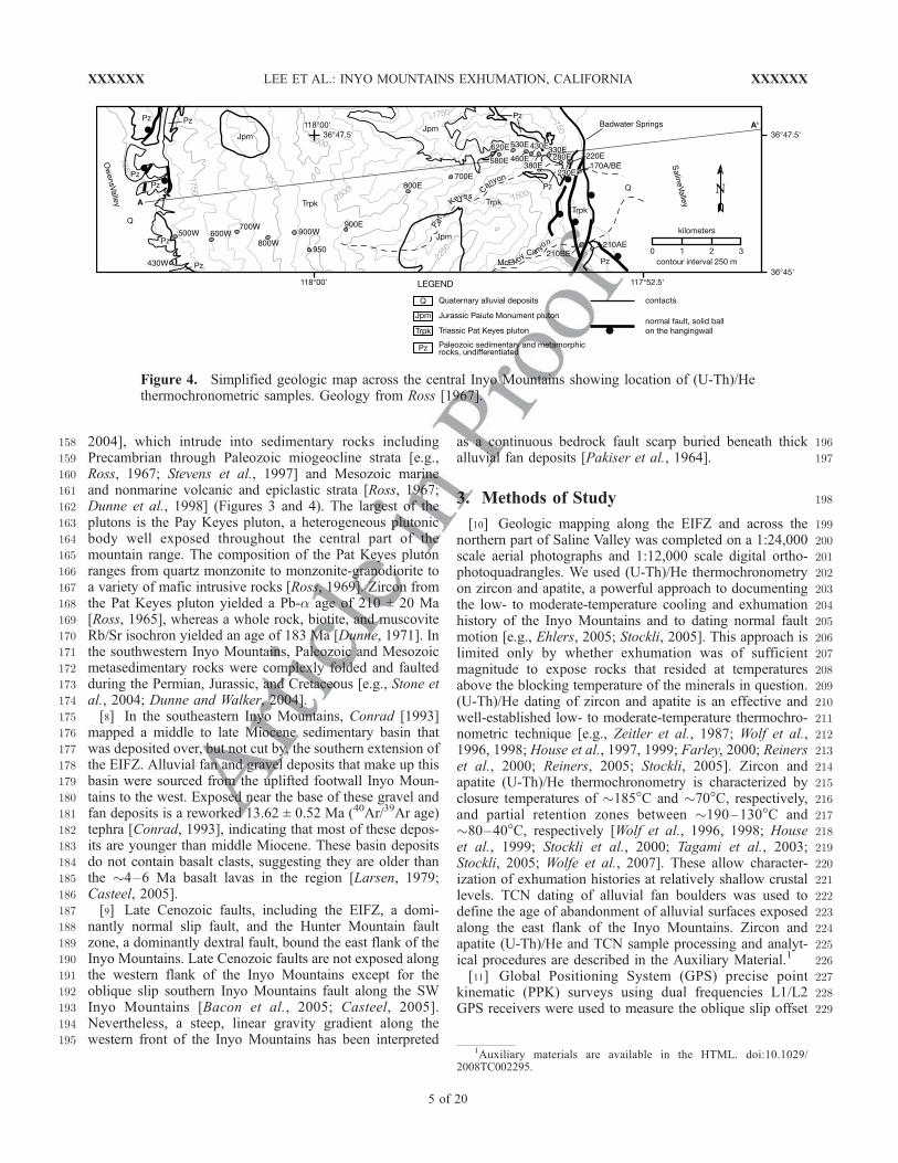
158 2004], which intrude into sedimentary rocks including159 Precambrian through Paleozoic miogeocline strata [e.g.,160 Ross, 1967; Stevens et al., 1997] and Mesozoic marine161 and nonmarine volcanic and epiclastic strata [Ross, 1967;162 Dunne et al., 1998] (Figures 3 and 4). The largest of the163 plutons is the Pay Keyes pluton, a heterogeneous plutonic164 body well exposed throughout the central part of the165 mountain range. The composition of the Pat Keyes pluton166 ranges from quartz monzonite to monzonite-granodiorite to167 a variety of mafic intrusive rocks [Ross, 1969]. Zircon from168 the Pat Keyes pluton yielded a Pb-a age of 210 ± 20 Ma169 [Ross, 1965], whereas a whole rock, biotite, and muscovite170 Rb/Sr isochron yielded an age of 183 Ma [Dunne, 1971]. In171 the southwestern Inyo Mountains, Paleozoic and Mesozoic172 metasedimentary rocks were complexly folded and faulted173 during the Permian, Jurassic, and Cretaceous [e.g., Stone et174 al., 2004; Dunne and Walker, 2004].175 [8] In the southeastern Inyo Mountains, Conrad [1993]176 mapped a middle to late Miocene sedimentary basin that177 was deposited over, but not cut by, the southern extension of178 the EIFZ. Alluvial fan and gravel deposits that make up this179 basin were sourced from the uplifted footwall Inyo Moun-180 tains to the west. Exposed near the base of these gravel and181 fan deposits is a reworked 13.62 ± 0.52 Ma (40Ar/39Ar age)182 tephra [Conrad, 1993], indicating that most of these depos-183 its are younger than middle Miocene. These basin deposits184 do not contain basalt clasts, suggesting they are older than185 the �4–6 Ma basalt lavas in the region [Larsen, 1979;186 Casteel, 2005].187 [9] Late Cenozoic faults, including the EIFZ, a domi-188 nantly normal slip fault, and the Hunter Mountain fault189 zone, a dominantly dextral fault, bound the east flank of the190 Inyo Mountains. Late Cenozoic faults are not exposed along191 the western flank of the Inyo Mountains except for the192 oblique slip southern Inyo Mountains fault along the SW193 Inyo Mountains [Bacon et al., 2005; Casteel, 2005].194 Nevertheless, a steep, linear gravity gradient along the195 western front of the Inyo Mountains has been interpreted
196as a continuous bedrock fault scarp buried beneath thick197alluvial fan deposits [Pakiser et al., 1964].
1983. Methods of Study
199[10] Geologic mapping along the EIFZ and across the200northern part of Saline Valley was completed on a 1:24,000201scale aerial photographs and 1:12,000 scale digital ortho-202photoquadrangles. We used (U-Th)/He thermochronometry203on zircon and apatite, a powerful approach to documenting204the low- to moderate-temperature cooling and exhumation205history of the Inyo Mountains and to dating normal fault206motion [e.g., Ehlers, 2005; Stockli, 2005]. This approach is207limited only by whether exhumation was of sufficient208magnitude to expose rocks that resided at temperatures209above the blocking temperature of the minerals in question.210(U-Th)/He dating of zircon and apatite is an effective and211well-established low- to moderate-temperature thermochro-212nometric technique [e.g., Zeitler et al., 1987; Wolf et al.,2131996, 1998; House et al., 1997, 1999; Farley, 2000; Reiners214et al., 2000; Reiners, 2005; Stockli, 2005]. Zircon and215apatite (U-Th)/He thermochronometry is characterized by216closure temperatures of �185�C and �70�C, respectively,217and partial retention zones between �190–130�C and218�80–40�C, respectively [Wolf et al., 1996, 1998; House219et al., 1999; Stockli et al., 2000; Tagami et al., 2003;220Stockli, 2005; Wolfe et al., 2007]. These allow character-221ization of exhumation histories at relatively shallow crustal222levels. TCN dating of alluvial fan boulders was used to223define the age of abandonment of alluvial surfaces exposed224along the east flank of the Inyo Mountains. Zircon and225apatite (U-Th)/He and TCN sample processing and analyt-226ical procedures are described in the Auxiliary Material.1
227[11] Global Positioning System (GPS) precise point228kinematic (PPK) surveys using dual frequencies L1/L2229GPS receivers were used to measure the oblique slip offset
Figure 4. Simplified geologic map across the central Inyo Mountains showing location of (U-Th)/Hethermochronometric samples. Geology from Ross [1967].
1Auxiliary materials are available in the HTML. doi:10.1029/2008TC002295.
XXXXXX LEE ET AL.: INYO MOUNTAINS EXHUMATION, CALIFORNIA
5 of 20
XXXXXX
232233 of debris flow levees across fault scarps and a tape measure234 and compass were used to measure the vertical offset of235 alluvial fan surfaces across normal fault scarps. Maximum236 vertical offsets of alluvial surfaces were calculated geomet-237 rically using the middle of the fault scarp [after Hanks et al.,238 1984]. Errors associated with lateral offset measurements239 include GPS survey points (�10 cm) and visually defining240 the location of the geomorphic feature in the field (0.5–1.0241 m); we report the latter error because it is the larger of the242 two and hence provides a conservative estimate of slip rates.243 Errors associated with the vertical offset measurements244 include far field slope and scarp angle measurements245 (typically 1–3�) and fault scarp downdip length measure-
246ment (0.2–0.3 m); these errors are incorporated into the247calculation of the vertical offset.
2484. Late Cenozoic Rock Units and Ages
249[12] The EIFZ, from Daisy Canyon northward, cuts and250offsets bedrock in the Inyo Mountains, Pliocene basalt and251andesite lava flows, and granite- and metamorphic derived252Quaternary coarse- to fine-grained alluvial fan and debris253flow deposits (Figures 1 and 3).254[13] Unit Tb, composed of Pliocene basalt and andesite255lavas, locally interbedded with subangular to subrounded256gravels at its base, underlie the Saline Range and small257bedrock mounds in northern Saline Valley [Ross, 1970;258Sternlof, 1988]. Whole rock samples from these typically259porphyritic plagioclase ± clinopyroxene ± olivine-bearing260lavas yield K/Ar ages that range from 1.4 ± 0.1 Ma to 3.7 ±2610.7 Ma [Ross, 1970; Larsen, 1979; Elliot et al., 1984;262Sternlof, 1988].263[14] Unit Tqs overlies unit Tb and comprise fanglomer-264ates that are composed of massive, indurated, poorly sorted,265angular sand to boulder-sized clasts, which have been266derived from older units.267[15] Along the eastern piedmont of the Inyo Mountains268and across the northern part of Saline Valley, four distinct269Quaternary alluvial fan surfaces were mapped on the basis270of surface morphology, including degree of dissection, inset271geometry, height above present-day stream grade, surface272texture, and tone or color on aerial photographs.273[16] A small remnant of the oldest alluvial fan surface,274Q1, is exposed in the central part of the map area 15–20 m275above present-day channels. This surface possesses a well-276developed desert pavement, rounded and dissected mor-277phology, and appears light colored in aerial photographs.278[17] The degree of surface dissection and morphology279allows Q2 surfaces to be subdivided into two mappable280units. In Waucoba Wash, at the northern end of Saline281Valley, the older Q2 surfaces, Q2a, are generally weakly282dissected smooth surfaces with widely (>100 m) spaced, up283to �10 m deep channels, and moderately to weakly devel-284oped desert pavement; these surfaces appear dark in aerial285photographs (Figure 5). Three quartzite boulders collected286from a Q2a surface yield a mean 10Be TCN model surface287age of 44.3 ± 12.1 ka (1 standard deviation) (sample288location X in Figure 3, see also Table 1). The younger289Q2b surfaces are generally exposed at the apex of alluvial290fan aprons along the eastern Inyo Mountains range front.291Alluvial fan deposits underlying these triangular-shaped292surfaces are sourced from east-draining canyons; cross-fan293profiles are convex up. These surfaces are debris flow294dominated with channels up to 5 m deep. On aerial photo-295graphs, these surfaces appear dark. Six granite boulders296were dated from a Q2b alluvial fan surface at the mouth of297McElvoy Canyon and four from a similar surface �2 km to298the southeast (sample locations Y and Z, respectively, in299Figure 3, see also Table 1). Four boulder samples from300McElvoy Canyon yield a mean 10Be TCN model surface301age of 18.3 ± 4.4 ka, whereas two boulder samples yield302ages of 91.2 ± 10.2 and 35.5 ± 3.4 ka, �70% older than the
Figure 5. Characteristics of deformed alluvial fan sur-faces. (a) Aerial photograph showing surface character ofQuaternary alluvial fan surfaces and normal fault scarps(indicated by arrows) in the southern Waucoba Wash. Pz,undifferentiated Paleozoic bedrock. (b) View to west of aSE-facing fault scarp developed within a Q2a alluvial fansurface. Surface offset of �2.6 m across the scarp. InyoMountains are in the background.
XXXXXX LEE ET AL.: INYO MOUNTAINS EXHUMATION, CALIFORNIA
XXXXXX LEE ET AL.: INYO MOUNTAINS EXHUMATION, CALIFORNIA
7 of 20
XXXXXX
303 other four samples. Three boulder samples collected from a304 similar surface to the southeast yield a mean 10Be model305 surface age of 17.7 ± 5.9 ka. One boulder sample from this306 surface yields an age of 46.4 ± 4.6, �89% ka older than the307 other three samples. We suggest that inheritance likely308 explains these older boulder ages.309 [18] The areally dominant alluvial fan surface, both along310 the range front and across northern Saline Valley, is Q3311 (Figure 5a). These surfaces are clearly inset into Q2312 surfaces, are characterized by plumose texture caused by313 bar and swale surface morphology, and appear yellow-tan to314 tan-white in aerial photographs.315 [19] The youngest surface, Q4, cuts all other surfaces316 and is composed of active and recently active channels317 (Figure 5a). These surfaces contain recent debris flow318 deposits, are relatively densely vegetated at the mouth of319 canyons with year-round water flow, but nearly devoid of320 vegetation far from the range front. These surfaces appear321 nearly white in aerial photographs.322 [20] Two landslide deposits, unit Qls, are exposed at the323 range front and are composed of Paleozoic strata and324 Mesozoic intrusive rocks. The lobate morphology of the325 landslides is distinctive and the source area is characterized326 by a concave up escarpment. The two landslides were327 deposited across the main trace of the EIFZ.328 [21] Locally exposed along the EIFZ-defined range front329 is unit Qc, an unconsolidated, generally medium to coarse330 grained sand and pebble-sized colluvium that often covers
331the range front fault scarp. Small dunes of medium- to fine-332grained sand define unit Qs.
3335. Fault Geometry, Geomorphology,
334Magnitude of Offset, and Slip Rates
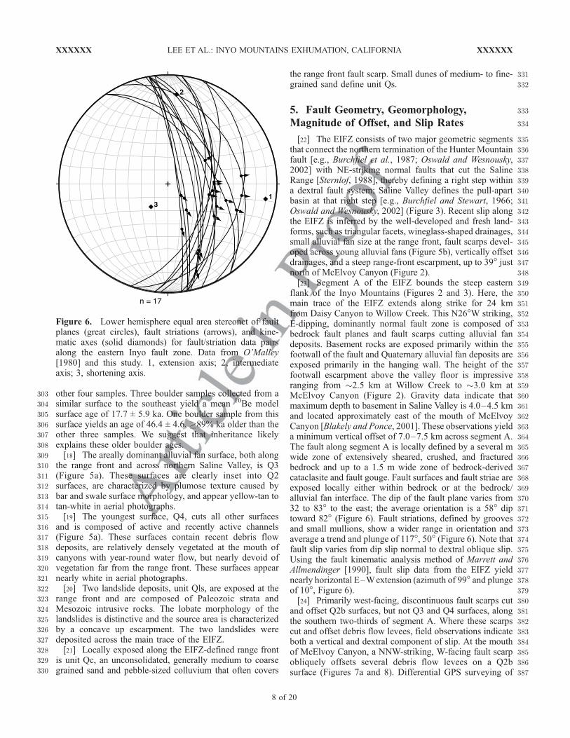
335[22] The EIFZ consists of two major geometric segments336that connect the northern termination of the Hunter Mountain337fault [e.g., Burchfiel et al., 1987; Oswald and Wesnousky,3382002] with NE-striking normal faults that cut the Saline339Range [Sternlof, 1988], thereby defining a right step within340a dextral fault system; Saline Valley defines the pull-apart341basin at that right step [e.g., Burchfiel and Stewart, 1966;342Oswald and Wesnousky, 2002] (Figure 3). Recent slip along343the EIFZ is inferred by the well-developed and fresh land-344forms, such as triangular facets, wineglass-shaped drainages,345small alluvial fan size at the range front, fault scarps devel-346oped across young alluvial fans (Figure 5b), vertically offset347drainages, and a steep range-front escarpment, up to 39� just348north of McElvoy Canyon (Figure 2).349[23] Segment A of the EIFZ bounds the steep eastern350flank of the Inyo Mountains (Figures 2 and 3). Here, the351main trace of the EIFZ extends along strike for 24 km352from Daisy Canyon to Willow Creek. This N26�W striking,353E-dipping, dominantly normal fault zone is composed of354bedrock fault planes and fault scarps cutting alluvial fan355deposits. Basement rocks are exposed primarily within the356footwall of the fault and Quaternary alluvial fan deposits are357exposed primarily in the hanging wall. The height of the358footwall escarpment above the valley floor is impressive359ranging from �2.5 km at Willow Creek to �3.0 km at360McElvoy Canyon (Figure 2). Gravity data indicate that361maximum depth to basement in Saline Valley is 4.0–4.5 km362and located approximately east of the mouth of McElvoy363Canyon [Blakely and Ponce, 2001]. These observations yield364a minimum vertical offset of 7.0–7.5 km across segment A.365The fault along segment A is locally defined by a several m366wide zone of extensively sheared, crushed, and fractured367bedrock and up to a 1.5 m wide zone of bedrock-derived368cataclasite and fault gouge. Fault surfaces and fault striae are369exposed locally either within bedrock or at the bedrock/370alluvial fan interface. The dip of the fault plane varies from37132 to 83� to the east; the average orientation is a 58� dip372toward 82� (Figure 6). Fault striations, defined by grooves373and small mullions, show a wider range in orientation and374average a trend and plunge of 117�, 50� (Figure 6). Note that375fault slip varies from dip slip normal to dextral oblique slip.376Using the fault kinematic analysis method of Marrett and377Allmendinger [1990], fault slip data from the EIFZ yield378nearly horizontal E–Wextension (azimuth of 99� and plunge379of 10�, Figure 6).380[24] Primarily west-facing, discontinuous fault scarps cut381and offset Q2b surfaces, but not Q3 and Q4 surfaces, along382the southern two-thirds of segment A. Where these scarps383cut and offset debris flow levees, field observations indicate384both a vertical and dextral component of slip. At the mouth385of McElvoy Canyon, a NNW-striking, W-facing fault scarp386obliquely offsets several debris flow levees on a Q2b387surface (Figures 7a and 8). Differential GPS surveying of
Figure 6. Lower hemisphere equal area stereonet of faultplanes (great circles), fault striations (arrows), and kine-matic axes (solid diamonds) for fault/striation data pairsalong the eastern Inyo fault zone. Data from O’Malley[1980] and this study. 1, extension axis; 2, intermediateaxis; 3, shortening axis.
XXXXXX LEE ET AL.: INYO MOUNTAINS EXHUMATION, CALIFORNIA
8 of 20
XXXXXX
388 offset debris flow levee apices yields a weighted mean389 dextral offset of 3.1 ± 0.7 m and vertical offset of 2.4 ±390 0.2 m, likely the result of a single earthquake. Assuming a391 fault dip of 50–70� yields horizontal extension of 1.5 ± 0.7 m392 and an oblique slip offset of 3.4 ± 0.7 m at 353 ± 12� since the393 abandonment of this surface at 18.3 ± 4.4 ka.394 [25] A NW-striking, SW-facing fault scarp cuts another395 Q2b surface at �2 km SE of McElvoy Canyon (Figure 7b).396 Here, differential GPS surveying of debris flow levee apices397 yields a weighted mean dextral offset of 2.4 ± 0.4 m and
398vertical offset of 1.5 ± 0.1 m. Assuming a fault dip of 50–39970� yields horizontal extension of 0.9 ± 0.4 m and an400oblique slip offset of 2.6 ± 0.4 m at 331 ± 9� since the401abandonment of this surface at 17.7 ± 5.9 ka. Relatively402fresh appearing bedrock fault scarps to the west of this fault403scarp suggests that here, at least, recent fault slip is404partitioned at the alluvial fan/bedrock interface and within405alluvial fan deposits.406[26] Segment B of the EIFZ extends from Willow Creek407northeastward (Figure 3). In this area, the EIFZ changes
Figure 7. Simplified differential GPS maps showing fault scarp trace and offset levee apices developedwithin Q2b surfaces and TCN sample locations for (a) McElvoy Canyon and (b) a Q2b surface �2 kmsouth of McElvoy Canyon. Magnitude of right lateral strike-slip (RL) and vertical offset (V) shown.Differential GPS survey points indicated by gray circles; fault traces by thick black lines; levee apices bythin black lines; projection of levee apices by gray triangles; arrows indicate relative motion across faults;black circles indicate TCN sample locations; TCN ages are indicated by italic fonts. Universal transverseMercator Zone 11 coordinates are World Geodetic System 84.
XXXXXX LEE ET AL.: INYO MOUNTAINS EXHUMATION, CALIFORNIA
9 of 20
XXXXXX
408 from a relatively narrow fault zone at the base of the Inyo409 Mountains to �15 km wide zone of �10�N–60�E striking,410 dominantly SE-dipping, but also NW-dipping, normal faults411 and fault scarps that cut pre-Tertiary rocks, Tertiary basalt412 lavas and gravels, and late Quaternary alluvial fan surfaces413 (Figures 3 and 5). Most fault scarps are well exposed in Q2a414 surfaces, but are locally exposed in Q3 surfaces, and absent415 across Q4 surfaces (Figure 5a). Fault scarps define SE- and416 NW-facing scarps, grabens, and nested grabens. Where fault417 scarps offset small debris flow channels or erosional escarp-418 ments cut into alluvial fan surfaces, geomorphic evidence419 indicates normal dip slip, but no dextral slip. Most scarps420 are mildly to moderately eroded and degraded, and sparsely421 vegetated (Figure 5b). In profile, fault scarp morphology422 varies from relatively short scarps with a single sharp423 knickpoint suggesting that these scarps formed by a single424 earthquake event to relatively tall, rounded scarps with more425 than one knickpoint suggesting that multiple earthquake426 events resulted in their formation. Where a single scarp can427 be traced from Q2 to Q3, that fault exhibits progressive428 offset with a larger vertical offset preserved within the Q2429 surface. Our measured vertical offsets across scarps ranges430 from 0.02 to 8.98 m. Seven transects across fault scarps431 developed in Q2a surfaces yield a net minimum horizontal432 extension (assuming a fault dip of 60�) of from 2.8 ± 0.8 m433 to 14.3 ± 1.4 m (Figure 3 and Table 2). These measure-434 ments, combined with the 10Be TCN model Q2a surface age435 of 44.3 ± 12.1 ka, yields a minimum horizontal slip rate of436 �0.1–0.4 mm/a.
438 6. Zircon and Apatite (U-Th)/He
439 Thermochronometry
440 [27] To document the low-temperature cooling history of441 granitic rocks exposed in the footwall of the EIFZ, 24442 samples were collected from the Mesozoic Pat Keyes443 pluton across the central part of the Inyo Mountains444 (Figures 4 and 9). Samples were collected from a range of445 intrusive lithologies including quartz monzonite to monzo-446 nite-granodiorite, aplite dike, and diorite. (U-Th)/He zircon
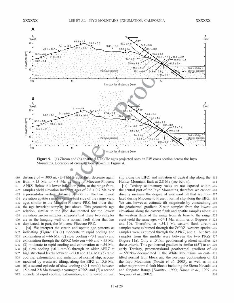
447and apatite age results are summarized in Table 3 and448Figures 9 and 10.449[28] (U-Th)/He zircon ages along the western flank of the450range and the top half of the eastern flank yield an elevation451invariant mean age of 65.8 ± 7.1 Ma (2s) (Figures 9 and45210), an age consistent with late Cretaceous/early Tertiary453cooling, regional exhumation of the Sierra magmatic arc, or454Laramide deformation [e.g., House et al., 1997, 2001;455Stockli et al., 2003; Clark et al., 2005; Bartley et al.,4562007]. (U-Th)/He zircon ages from the middle part of the457eastern flank of the range decrease down elevation from458�66 to �54 Ma defining a Paleocene zircon partial reten-459tion zone (ZrPRZ). Below this inflection point, samples460yield elevation invariant (U-Th)/He zircon ages of 55.0 ±4619.8 Ma over a present-day vertical distance of �500 m. The462two lowest elevation samples on the east side of the range463yield ages similar to those in the ZrPRZ, but older than464samples just above. This geometric age relation suggests465that these two samples are in the hanging wall of a normal466fault sliver that has duplicated, in part, the Eocene ZrPRZ.467Although a fault to the west of these samples has been468mapped (Figure 4), the absence of appropriate geologic469markers make it impossible to confirm the magnitude of this470inferred offset, nevertheless duplication of apatite fission471track data [e.g., Fitzgerald, 1992; Foster and Gleadow,4721996] and (U-Th)/He data [Stockli et al., 2003] have been473used to estimate the magnitude of normal fault offset.474[29] (U-Th)/He apatite ages along the western flank of the475range from its base to the range crest yield an elevation476invariant mean age of 53.2 ± 6.6 Ma (Figures 9 and 10), an477age also consistent with late Cretaceous/early Tertiary cool-478ing, regional exhumation of the Sierra magmatic arc, or479Laramide deformation [e.g., House et al., 1997, 2001;480Stockli et al., 2003; Clark et al., 2005; Bartley et al.,4812007]. Apatite (U-Th)/He ages from deeper structural levels482exposed on the east side of the range define two exhumed483apatite partial retention zones (APRZs) and inflection points484(Figures 9 and 10). From the crest of the range, ages485systematically decrease down the east side from �53 Ma486to �16 Ma defining an Eocene-Miocene APRZ. Below487this upper inflection point, samples yield elevation invariant488(U-Th)/He ages of 15.6 ± 2.4 Ma over a present-day vertical
Figure 8. View looking NNWat the SW-facing fault scarpcutting a Q2b surface at McElvoy Canyon. Main trace of theEIFZ and exhumed Inyo Mountain footwall block in thebackground.
t2.1Table 2. Measured Horizontal Offsets and Calculated Slip Rates
Across Normal Fault Scraps That Cut Dated Alluvial Fan Surfaces
Along Transects Parallel to the Extension Directiona
aSee Figure 3 for location of transects. t2.10bAssumes 60� fault. t2.11
XXXXXX LEE ET AL.: INYO MOUNTAINS EXHUMATION, CALIFORNIA
10 of 20
XXXXXX
489 distance of �1000 m. (U-Th)/He ages then decrease again490 from �15 Ma to �3 Ma defining a Miocene-Pliocene491 APRZ. Below this lower inflection point, at the range front,492 samples yield elevation invariant ages of 2.8 ± 0.7 Ma over493 a present-day vertical distance of �75 m. The two lowest494 elevation apatite samples on the east side of the range yield495 ages similar to the Miocene-Pliocene PRZ, but older than496 the age invariant samples just above. This geometric age497 relation, similar to the one documented for the lowest498 elevation zircon samples, suggests that these two samples499 are in the hanging wall of a normal fault sliver that has500 duplicated, in part, the Miocene-Pliocene PRZ.501 [30] We interpret the zircon and apatite age patterns as502 indicating (Figure 10) (1) moderate to rapid cooling and503 exhumation at �66 Ma; (2) slow cooling (<0.1 mm/a) and504 exhumation through the ZrPRZ between �66 and �55 Ma;505 (3) moderate to rapid cooling and exhumation at �54 Ma;506 (4) slow cooling (<0.1 mm/a) through an older APRZ at507 high structural levels between �53.0 and 15.6 Ma; (5) rapid508 cooling, exhumation, and initiation of normal slip, accom-509 modated by westward tilting, along the EIFZ at 15.6 Ma;510 (6) a second episode of slow cooling (<0.1 mm/a) between511 15.6 and 2.8 Ma through a younger APRZ; and (7) a second512 episode of rapid cooling, exhumation, and renewed normal
513slip along the EIFZ, and initiation of dextral slip along the514Hunter Mountain fault at 2.8 Ma (see below).515[31] Tertiary sedimentary rocks are not exposed within516the central part of the Inyo Mountains, therefore we cannot517directly measure the degree of westward tilt that accumu-518lated during Miocene to Present normal slip along the EIFZ.519We can, however, estimate tilt magnitude by constraining520the geothermal gradient. Zircon samples from the lowest521elevations along the eastern flank and apatite samples along522the western flank of the range from its base to the range523crest yield the same age, �54.1 Ma, within error (Figures 9524and 10). Therefore, at �54.1 Ma eastern flank zircon525samples were exhumed through the ZrPRZ, western apatite526samples were exhumed through the APRZ, and all but two527samples from the middle were between the two PRZs528(Figure 11a). Only a 15�/km geothermal gradient satisfies529these criteria. This geothermal gradient is similar (±5�) to an530early Tertiary, preextensional geothermal gradient of531�15�C/km documented in the White Mountains, an east-532tilted normal fault block and the northern continuation of533the Inyo Mountains [Stockli et al., 2003], as well as in534other major normal fault blocks including the Sierra Nevada535and Singatse Range [Dumitru, 1990; House et al., 1997;536Surpless et al., 2002].
Figure 9. (a) Zircon and (b) apatite (U-Th)/He ages projected onto an EW cross section across the InyoMountains. Location of cross section shown in Figure 4.
XXXXXX LEE ET AL.: INYO MOUNTAINS EXHUMATION, CALIFORNIA
11 of 20
XXXXXX
537 [32] To place bounds on the exhumation history and538 degree of westward tilt in the Inyo Mountains, we restored539 sample positions using the following:540 [33] 1. Our estimated preextensional, late Cretaceous/541 early Tertiary geothermal gradient of 15�C/km and a mean542 annual surface temperature of 10�C. We assume a linear
543geothermal gradient, which is probably reasonable for544shallow crustal levels [e.g., Stockli et al., 2002], but likely545not so at deep structural levels.546[34] 2. A preextensional middle Miocene geothermal547gradient of 15�C/km, similar to the middle Miocene geo-
t3.1 Table 3. Summary of Zircon and Apatite (U-Th)/He Sample Parameters, Analytical Data, and Mean Age for Samples Collected Across
the Inyo Mountainsa
Sample Latitudeb Longitudeb Elevation (m) Mass (mg) He (ncc/mg) U (ppm) Th (ppm) Ft Mean Age (Ma) ±2sc (Ma) Replicatesdt3.2
aSee Figures 4 and 9 for location of samples.t3.57bWorld Geodetic System 84 datum.t3.58cErrors on single replicate analyses are 6 percent (2 s) and are the analytical uncertainty on laboratory internal reproducibility.t3.59dNumber of replicates per sample. See Auxillary Material A for replicate analyses.t3.60
XXXXXX LEE ET AL.: INYO MOUNTAINS EXHUMATION, CALIFORNIA
12 of 20
XXXXXX
548 thermal gradient documented in the White Mountains549 [Stockli et al., 2003].550 [35] 3. An increase in geothermal gradient to 35�C/km551 during the Pliocene, as has been documented in the Wassuk552 Range [Stockli et al., 2002]. The extensive Pliocene basalt553 and andesite lavas exposed along the eastern flank of the554 Inyo Mountains and in the Saline Range [Ross, 1970;555 Larsen, 1979; Elliot et al., 1984; Sternlof, 1988], as well556 as the six heat flow sites in Saline Valley, which yield a near557 surface mean geothermal gradient of 38�C/km, suggest that558 this increase in geothermal gradient is reasonable. If we559 minimize the magnitude of late Cretaceous/early Paleocene560 tilt of the Inyo Mountains, then its low-temperature exhu-561 mation history began at �66 with at least 7.5 km of slow562 to rapid (�0.5 mm/a) exhumation through the ZrPRZ563 (Figure 11a). Between �66 and �54 Ma, little or no564 significant exhumation occurred. At �54.1 Ma, the Inyo565 Mountains were moderately to rapidly exhumed (�0.8 mm/a)566 �3.9 km and tilted 12�eastward through the APRZ567 (Figure 11a). Between �54 Ma and �16 Ma, the Inyo568 Mountains were essentially static. The rapid (� 1.9 mm/a)569 episode of exhumation at �15.6 Ma was characterized by570 �16� of westward tilt and exhumation of the eastern flank571 by �5.3 km through the APRZ (Figure 11a). Between572 �15.6 and �2.8 Ma, the Inyo Mountains were characterized573 by slow exhumation (0.1–0.2 mm/a) and 4� of westward574 tilt. This period was followed by an increase in the geo-575 thermal gradient to 35�C/km and onset of somewhat faster576 exhumation (0.4–0.7 mm/a), �4� of westward tilt, and577 1.5 km exhumation of the eastern flank of the range through578 the upper part of the APRZ at �2.8 Ma (Figure 11a).579 [36] Alternatively, the reconstructions yield a somewhat580 different early exhumation history if we minimize the
581magnitude of the late Cretaceous/early Paleocene exhuma-582tion (Figure 11b). In this scenario, the Inyo Mountains were583exhumed �6.4 km at a slow to rapid rate (�0.5 mm/a) at584�66 Ma. This was followed by a period of stasis between585�66 and �54 Ma and then a period of significant exhuma-586tion (�5.6 km) at a rate of �1.1 mm/a accompanied by 20�587eastward tilt at �54.1 Ma. The younger history of exhuma-588tion follows that described above (Figure 11a).589[37] In summary, zircon and apatite (U-Th)/He data590indicate four major episodes of moderate to rapid exhuma-591tion and tilting: (1) a late Cretaceous/early Paleocene592episode of 6.4–7.5 km of exhumation; (2) an early Eocene593episode of 3.9–5.6 km of exhumation; (3) a middle594Miocene episode of rapid cooling, �5.3 km of exhumation,595and 16� of westward tilt; and (4) a Pliocene to Recent596episode of renewed rapid cooling, �1.5 km of exhumation,597and 4� of westward tilt. In addition, the (U-Th)/He data598indicate a protracted episode (�40 Ma) of stasis from the599early Eocene to middle Miocene. Exhumation of the Inyo600Mountains commenced in the late Cretaceous/early Tertiary601along structure(s) that have not yet been identified. This602period of exhumation was followed by a prolonged phase of603slow erosion which ended with two late Tertiary episodes of604exhumation and westward tilting along the down to the east605normal slip EIFZ (see below).606[38] We can calculate the magnitude of downdip slip607along the EIFZ since inception of slip at �15.6 Ma using608an estimate of �8.5 km of vertical exhumation (based on a609geothermal gradient of 15�C/km) for the eastern most610samples, 24� of westward tilt (Figure 11a), and assuming611an initial fault dip of 60 ± 10�. These constraints yield612downdip normal slip and horizontal extension amounts of613between 9.8 +1.3/–0.8 (60 ± 10� dipping fault) and 14.5614+4.9/–2.7 (36 ± 10� dipping fault) km, and between 4.9615+2.2/–1.8 and 11.7 +5.7/–3.5 km, respectively. Combining616the dip slip and horizontal extension measurements that617accumulated since onset of extension at 15.6 ± 2.4 Ma618yields a middle Miocene dip slip rate of between 0.6 ± 0.1619and 0.9 +0.4/–0.2 mm/a and horizontal extension rate of620between 0.3 +0.2/–0.1 and 0.8 +0.4/–0.2 mm/a.
6217. Discussion
6227.1. Late Cretaceous/Early Tertiary Exhumation
623[39] Late Cretaceous to early Tertiary apatite fission track624and (U-Th)/He ages have been documented in several625normal fault blocks in the western Basin and Range Prov-626ince including the Sierra Nevada, White Mountains, Wassuk627Range, Singatse Range, Pine Nut Mountains, and Carson628Range [Dumitru, 1990; House et al., 1997, 2001; Stockli et629al., 2002, 2003; Surpless et al., 2002; Clark et al., 2005].630These ages have been interpreted as either refrigeration631during shallow Laramide subduction [Dumitru, 1990], cool-632ing of the Sierra Nevada magmatic arc [Stockli et al., 2003],633or protracted late Cretaceous-early Tertiary erosional634unroofing [House et al., 1997; Stockli et al., 2002; Surpless635et al., 2002; Clark et al., 2005].636[40] The two episodes of late Cretaceous/early Tertiary637moderate to rapid exhumation and tilting of the Inyo
Figure 10. Plot of zircon and apatite (U-Th)/He agesversus elevation showing the cooling history for the InyoMountains.
XXXXXX LEE ET AL.: INYO MOUNTAINS EXHUMATION, CALIFORNIA
13 of 20
XXXXXX
A
B
Figure 11
XXXXXX LEE ET AL.: INYO MOUNTAINS EXHUMATION, CALIFORNIA
14 of 20
XXXXXX
638 Mountains are not compatible with either of these interpre-639 tations but are broadly similar in time with Laramide640 deformation.Wells and Hoisch [2008, and reference therein]641 summarize several studies that suggest extension was wide-642 spread throughout the interior of the Laramide orogeny,643 however the timing of that deformation is generally not well644 defined. In the vicinity of the Inyo Mountains, the best645 geochronologic constraints on Laramide deformation come646 from the Funeral and Black mountains and across Owens647 Valley, the valley bounding the western flank of the Inyo648 Mountains. In the Funeral Mountains, field and U/Pb zircon649 geochronologic data show a major extensional unroofing650 event that was ongoing at 72 ± 1 Ma and ceased by 70 ±651 1 Ma [Applegate et al., 1992], prior to the low-temperature652 exhumation history recorded in the Inyo Mountains. Field653 and geochronologic data from the Black Mountains, located654 �55 km south of the Funeral Mountains, indicate an655 episode of contractional deformation between 61 and656 55 Ma [Miller and Friedman, 1999; Miller and Pavlis,657 2005;Miller, 2003], approximately the same time as the two658 episodes of exhumation recorded in the Inyo Mountains.659 Across Owens Valley, �65 km of dextral offset is indicated660 by the 87Sr/86Sr = 0.706 isotopic isopleth in the Mono Lake661 area, a Middle Devonian submarine channel, Permo-Trias-662 sic structures, and the late Cretaceous Golden Bear dike/663 Coso dikes [Kistler, 1993; Stevens et al., 1997; Kylander-664 Clark et al., 2005]. The timing of offset postdates the665 emplacement of the Golden Bear and Coso dikes at666 �83 Ma [Kylander-Clark et al., 2005]. Bartley et al.667 [2007] and Glazner et al. [2005] suggested that as much as668 50–60 km of the dextral offset accumulated during the late669 Cretaceous to early Tertiary (Laramide time). Furthermore,670 Bartley et al. [2007] postulated that this episode of NW671 dextral slip was linked to an extensional step over in the672 southern Sierra Nevada, where Wood and Saleeby [1997]673 proposed �90–85 Ma to �55–50 Ma south to southeast674 extension along normal faults and an extensional detachment675 system that unroofed the southern Sierra Nevada batholith.676 We speculate that the two late Cretaceous/early Tertiary677 episodes of exhumation documented in the Inyo Mountains678 indicate two phases of Laramide deformation associated with679 dextral slip across Owens Valley.680 [41] The early Eocene episode of rapid exhumation was681 followed by a prolonged period (�40 Ma) of quiescence.682 The lack of exhumation during this time period suggests683 development of a slowly eroding surface, as has been684 proposed for the Sierra Nevada between 80 and 32 Ma
685[Clark et al., 2005], of which the Inyo Mountains were a686part prior to the onset of late Tertiary extension.
6877.2. Basin and Range Extension
688[42] Geologic mapping, structural, and kinematic studies,689combined with apatite (U-Th)/He thermochronometry, show690that the EIFZ is characterized by two normal fault segments,691an InyoMountain range bounding, NNW-striking, E-dipping692normal to normal oblique slip fault and a broad zone of693NE-striking normal fault scarps cutting across northern694Saline Valley and projecting into the Saline Range (Figures 1,6952, and 3). Apatite (U-Th)/He thermochronometry results696across the Inyo Mountains yield age patterns that indicate697two periods of rapid cooling, exhumation, and normal slip.698Normal slip initiated at 15.6 Ma and did not last for more699than �1.5 Ma as demonstrated by �13.62 ± 0.52 Ma700alluvial fan sediments deposited across, but not cut by, the701southeast extension of the EIFZ in the southern Inyo702Mountains [Conrad, 1993]. A second episode of normal703slip began at 2.8 Ma and fault scarps that cut late Pleisto-704cene alluvial fan surfaces indicate the EIFZ is still active705today.706[43] Middle Miocene initiation of normal slip along the707EIFZ is similar in age to the initiation of normal slip and tilt708documented along a number of major fault blocks to the709north. Normal faulting and eastward tilt in the White710Mountains began at �12 Ma [Stockli et al., 2003]. Farther711to the north, large magnitude extension in the Yerington712area and normal faulting and westward tilt of the Singatse713and Wassuk Ranges started at 13–15 Ma [Dilles and Gans,7141995; Stockli et al., 2002; Surpless et al., 2002]. Normal715faulting initiated at �12 Ma along the east-dipping Donner716Pass fault zone located within the eastern margin of the717Sierra Nevada southwest of Reno, Nevada [Henry and718Perkins, 2001]. These normal fault blocks define a 20�N–71930�W-trending zone of middle Miocene, approximately720NS-striking, west-stepping, en echelon normal faults along721the western margin of the Basin and Range Province. If the722southern part of the Sierra Nevada frontal fault zone was not723active during the middle Miocene (but see below), then724these fault blocks define a middle Miocene breakaway zone725along the boundary between highly extended Basin and726Range Province to the east from the unextended Sierra727Nevada to west [Surpless et al., 2002]. Middle Miocene728extension in this region of the Basin and Range Province729has been attributed to development of a slab window [e.g.,
Figure 11. (a) Restored positions of zircon and apatite (U-Th)/He samples using a late Cretaceous to middle Tertiarygeothermal gradient of 15�C/km and a Pliocene to present geothermal gradient of 35�C/km and assuming horizontalisotherms (see text for discussion). This reconstruction minimizes the magnitude of tilt during the late Cretaceous/earlyTertiary exhumation episode. Late Cretaceous to early Tertiary and middle Miocene zircon partial retention zone indicatedby left-slanted line shading and apatite partial retention zone indicated by gray shading; Pliocene APRZ indicated by right-slanted line shading. Onset and end show sample positions at the beginning and cessation, respectively, of a period of rapidcooling and exhumation. (b) Restored positions of zircon and apatite (U-Th)/He samples using a late Cretaceous to middleTertiary geothermal gradient of 15�C/km, horizontal isotherms, and a reconstruction that minimizes the magnitude ofexhumation during the late Cretaceous/early Tertiary exhumation episode (cf. Figure 11a). The younger exhumation historyis the same as in Figure 11a. ZrPRZ indicated by left slanted line shading and APRZ indicated by gray shading. Onset andend show sample positions at the beginning and cessation, respectively, of a period of rapid cooling and exhumation.
15 of 20
XXXXXX LEE ET AL.: INYO MOUNTAINS EXHUMATION, CALIFORNIA XXXXXX
730 Atwater and Stock, 1998; Dickinson, 2002] or a combina-731 tion of forces external to the region including plate bound-732 ary forces, an increased gravitational potential energy in the733 northern Basin and Range Province, and lateral forces in the734 southern Basin and Range Province [Sonder and Jones,735 1999].736 [44] The renewed episode of normal slip along the EIFZ737 during the Pliocene is also similar in age to the timing of738 renewed slip along many of the same fault systems to the739 north that experienced slip during the middle Miocene.740 Younger extension at the northern end of the White Moun-741 tains initiated at �3 Ma [Stockli et al., 2003], while renewed742 normal slip in the Wassuk Range began at<4 Ma [Stockli et743 al., 2002]. Along the eastern margin of the Sierra Nevada744 west of Reno, extension restarted at �3 Ma [Henry and745 Perkins, 2001], and the initiation of extension along the746 eastern margin of Sierra Nevada in the Tahoe-Truckee747 asymmetric half graben occurred after 5 Ma [Surpless et748 al., 2002].749 [45] A number of observations, including westward tilted750 Neogene strata [Unruh, 1991; Wakabayashi and Sawyer,751 2001], high incision rates [Stock et al., 2004], and the752 petrology, geochemistry, and geochronology of volcanic753 rocks and entrapped xenoliths [e.g., Ducea and Saleeby,754 1996; Farmer et al., 2002; Manley et al., 2000; see also755 Jones et al., 2004], suggest tectonic uplift and westward tilt756 of the Sierra Nevada west of the Inyo Mountains at 5–757 3.5 Ma. This episode of extension has been attributed to758 removal of dense lithosphere from beneath the Sierra759 Nevada at �3.5 Ma that initiated uplift and increased760 extensional strain rates within a 50 km distance east of761 the Sierra Nevada [e.g., Ducea and Saleeby, 1996; Jones et762 al., 2004; Zandt et al., 2004]. The second, Pliocene, episode763 of normal slip along the EIFZ is consistent with this764 hypothesis.765 [46] The absence of Cenozoic rocks that can be correlated766 across the Sierra Nevada and into Owens Valley and late767 Cenozoic low-temperature thermochronometry ages pre-768 cludes directly dating initiation of slip along this section769 of the Sierra Nevada frontal fault zone. However, combin-770 ing geomorphology and (U-Th)/He thermochronometry,771 Clark et al. [2005] concluded that the southern Sierra772 Nevada experienced an episode of exhumation between773 32 and 3.5 Ma. Furthermore, combining a minimum vertical774 relief of �2.5 km at the latitude of Mt. Whitney with the775 assumption that late Pleistocene to Holocene vertical slip776 rates of 0.2–0.3 mm/a along the Sierra Nevada frontal fault777 zone [Le et al., 2007] have remained constant through time778 implies that the eastern escarpment here may be at least as779 old as �9–13 Ma. Finally, Sierran derived sandstones,780 gravels, and boulders observed in �8 Ma basin deposits781 along the southeastern most Sierra Nevada implies tectonic782 uplift at this time [Loomis and Burbank, 1988]. Although783 not conclusive, these observations suggest that normal slip784 along the Sierra Nevada frontal fault zone west of the Inyo785 Mountains was ongoing during the middle to late Miocene.786 If correct, then the Sierra Nevada frontal fault zone would787 have formed a breakaway zone with the west-tilted Inyo788 Mountains in its hanging wall.
7897.3. Eastern California Shear Zone
790[47] As extension shifted westward at the latitude of791�38.5� and �36.5�, the rigid Sierra Nevada block became792narrower [Surpless et al., 2002; Jones et al., 2004], and793because it lies within a transform plate boundary, Sonder794and Jones [1999] postulated that shear strain was localized795along its boundaries. Thus, an increase in dextral shear at796�3.5 Ma is predicted within the ECSZ [Jones et al., 2004],797a hypothesis supported by the interpretation that initiation of798normal slip along the NE-striking Queen Valley at 3.0 ±7990.5 Ma signals the onset of dextral slip along the Owens800Valley-White Mountains fault zone [Stockli et al., 2003].801Similarly, the Pliocene slip history along the EIFZ is related802to the onset of dextral shear within the ECSZ.803[48] The northern termination of the dextral Hunter804Mountain fault is defined by the EIFZ while the normal805slip Panamint Valley fault defines the southern termination806(Figure 1). The Saline and Panamint valleys are pull-apart807basins in this right-stepping geometry. The EIFZ, therefore,808transfers dextral slip from the Hunter Mountain fault to809normal faults within the Saline Range and Dry Mountain,810which, in turn, transfer slip across to the dextral Furnace811Creek fault [e.g., Dixon et al., 1995; Lee et al., 2001]. As a812consequence, the timing of Pliocene slip along the EIFZ has813implications for the onset and rate of slip along the Hunter814Mountain fault and for the total geologic slip rate across the815ECSZ.816[49] The intersection line defined by a subhorizontal817basalt flow capping a subvertical contact between the818Hunter Mountain batholith and Paleozoic rocks is dextrally819offset 9.3 ± 1.4 km across the Hunter Mountain fault820[Burchfiel et al., 1987; Sternlof, 1988]. This maximum821measured dextral offset accumulated since 4.63 ± 0.06 Ma,822the age of the youngest basalt flow, indicating a minimum823dextral slip rate of 2.0 ± 0.3 mm/a [Burchfiel et al., 1987;824Sternlof, 1988]. Sternlof [1988] calculated 8.9 ± 2.5 km of825horizontal extension across the Saline Range, the same,826within error, as the dextral offset across the Hunter Moun-827tain fault, supporting the kinematic configuration whereby828the EIFZ transfers slip from the Hunter Mountain fault to829NE-striking normal faults exposed in the Saline Range.830Sternlof [1988] further argued that 4.5 ± 0.1 km of hori-831zontal extension across the Saline Range can account for the832dextral slip along the Hunter Mountain fault since 1.37 ±8330.01 Ma, yielding a minimum dextral slip rate of 3.2 ±8340.1 mm/a. These studies show that the initiation of dextral835slip along the Hunter Mountain fault is bracketed between8364.6 and 1.4 Ma. Finally, Oswald and Wesnousky [2002]837calculated a late Pleistocene dextral slip rate of 3.3–4.0 mm/a838across the Hunter Mountain fault based on a 50–60 m839dextrally offset drainage developedwithin an alluvial surface,840whose geomorphic characteristics along with climate factors841suggest is �15 ka.842[50] We suggest that the episode of renewed normal slip843along the EIFZ at 2.8 ± 0.7 Ma signals the onset of dextral844slip along the Hunter Mountain fault and extension across845the Saline Range because the EIFZ forms the northern846termination of the Hunter mountain fault. If correct, then847the total dextral offset of 9.3 ± 1.4 km along the Hunter
XXXXXX LEE ET AL.: INYO MOUNTAINS EXHUMATION, CALIFORNIA
16 of 20
XXXXXX
848 Mountain fault [Sternlof, 1988] accumulated at a rate of849 3.3 ± 1.0 mm/a since the Pliocene. This long-term slip rate850 is the same, within error, as Sternlof’s [1988] calculated851 early Pleistocene dextral slip rate and Oswald and852 Wesnousky’s [2002] estimated latest Pleistocene slip rate.853 Our estimate for the age of initiation of dextral slip along854 the Hunter Mountain fault is the same, within error, to that855 for the Owens Valley-White Mountains fault zone [Stockli856 et al., 2003], and consistent with Jones et al.’s [2004]857 hypothesis that dextral shear increased within the western858 part of the ECSZ during the Pliocene.859 [51] Our calculated dextral slip rate along the Hunter860 Mountain fault, combined with calculated dextral slip rates861 for the other three major dextral strike-slip faults, the862 southern Owens Valley, northern Death Valley, and Stateline863 faults, provides an estimate of the cumulative slip rate864 across the ECSZ at the latitude of �36.5� (Figures 1865 and 12 and Table 4). A Holocene dextral slip rate of 1.0 ±866 0.4 mm/a was estimated by Bacon and Pezzopane [2007]
867across the southern Owens Valley fault based on paleoseis-868mic studies. Frankel et al. [2007] report a dextral slip rate of8694.2 +1.9/–1.1 to 4.7 +0.9/–0.6 mm/a across the northern870Death Valley fault based on 297 ± 9 m offset of an alluvial871fan surface with a maximum and minimum age of 70 +22/–87220 ka and 63 ± 8 ka, respectively. Along the southern part of873the Stateline fault, Guest et al. [2007] calculated a minimum874middle Miocene dextral slip rate of 2.3 ± 0.1 mm/a based on87530 ± 1 km dextral offset of middle Miocene volcanic876deposits. This slip rate is considerably higher than geodetic877estimates of 0.7–1.2 mm/a [Wernicke et al., 2004; Hill and878Blewitt, 2006], which was measured across the northern part879of the fault. Guest et al. [2007] postulated that one potential880explanation for this discrepancy is an along strike change in881displacement rate along the Stateline fault. The lower rate of882�1 mm/a on the northern segment may be the consequence883of transfer of �55% of the dextral slip from the southern884segment northwestward onto the Death Valley fault via a left885step.886[52] Summing geologic slip rates, calculated parallel to887Pacific-North America plate motion (N47�W) [Dixon et al.,8882000], from the Owens Valley, northern Death Valley, and889Stateline faults with the slip rate determined for the Hunter890Mountain fault in this study and assuming slip rates were891constant through time, yields a total long-term geologic slip892rate of 9.3 +2.2/–1.4 to 9.8 +1.4/–1.0 mm/a (Figure 12 and893Table 4). Our geologic slip rate estimate is the same as894Frankel et al.’s [2007] recent geologic slip rate estimate,895although they used a somewhat faster slip rate for the896Owens Valley fault and did not calculate rates parallel to897Pacific-North American plate motion. Our estimated long-898term geologic slip rate is also the same, within error, to the899geodetic estimate of 9.3 ± 0.2 mm/a across this segment of900the ECSZ [Bennett et al., 2003]. Finally, taking into account901the errors associated with each geologic slip rate estimate,902the distribution of dextral shear across the ECSZ was903concentrated along the northern Death Valley fault904(�45%), with somewhat lesser slip along the Hunter Moun-905tain fault (�35%). The remaining 20% of slip appears to be906distributed equally along the two faults that bound the907eastern California shear zone, the southern Owens Valley908and Stateline faults.
9108. Conclusions
911[53] New geologic mapping, zircon and apatite (U-Th)/He912ages, and 10Be TCN alluvial fan surface abandonment ages913along the eastern Inyo fault zone yield insight into the914development of the Inyo Mountains as a major fault block915within the ECSZ and western margin of the Basin and916Range Province. We suggest that late Cretaceous/early917Tertiary moderate to rapid exhumation of the range was918related to Laramide deformation along the eastern margin of919the present-day Sierra Nevada. Two episodes of normal slip920along the EIFZ, initiation of slip at �15.6 Ma and renewed921slip at �2.8 Ma, exhumed the Inyo Mountains in its922footwall. The first episode of normal slip did not last longer923than �1.5 Ma, whereas the second episode continues today.924The Inyo Mountains block was exhumed at an average,
Figure 12. Simplified fault map of the eastern Californiashear zone showing active and recently active faults andgeologically determined dextral slip rates in mm/a [Baconand Pezzopane, 2007; Frankel et al., 2007; Guest et al.,2007; this work]. Squares indicate location of the calculatedslip rate. AHF, Ash Hills fault; DSF, Deep Springs fault;EIFZ, eastern Inyo fault zone; FLVFZ, Fish Lake Valleyfault zone; GF, Garlock fault; HMF, Hunter Mountain fault;NDVFZ, Northern Death Valley fault zone; OVF, OwensValley fault; PVF, Panamint Valley fault; TPF, Towne Passfault; SDVF, Southern Death Valley fault; SLF, Statelinefault; SNFFZ, Sierra Nevada frontal fault zone; WMFZ,White Mountains fault zone.
XXXXXX LEE ET AL.: INYO MOUNTAINS EXHUMATION, CALIFORNIA
17 of 20
XXXXXX
925 long-term dip slip rate of 0.5–1.2 mm/a. The initiation of926 slip at �15.6 Ma along the EIFZ is similar in age to927 initiation of normal slip along major range bounding normal928 faults within the western margin of the Basin and Range929 Province. This set of en echelon normal fault blocks may930 have defined the western boundary of the Basin and Range931 Province east of the present-day Sierra Nevada during the932 Miocene. The second episode of normal slip signals the933 onset of dextral slip along the Hunter Mountain fault, one of934 four major dextral faults that accommodate dextral shear935 across the ECSZ. Summing dextral slip rates on the Owens936 Valley, Hunter Mountain, northern Death Valley, and State-937 line faults at the latitude of �36.5� yields long-term938 geologic slip rates of 7.9–11.2 mm/a, the same as geodetic939 rates across this part of the ECSZ. Taking into account
940errors associated with each geologic slip rate estimate, the941northern Death Valley fault accommodated most of the942dextral slip rate across the ECSZ.
943[54] Acknowledgments. Tom Budlong’s knowledge of the early to944middle 20th century miners’ trails in the Inyo Mountains was instrumental945to successfully collecting (U-Th)/He samples across the mountains. Thanks946to Tom Budlong, Jeff Schroeder, Kit Tincher, and Kelly Wooten for their947assistance in collecting these samples. Jeff Schroeder also helped with948differential GPS surveying. John Casteel, Yeong Bae Seong, Scott Heiztler,949John Oswald, and Sam Clemens lent a hand with collection of the TCN950samples. Stephanie Brichau managed the (U-Th)/He laboratory at the951University of Kansas and trained one us (J.L.) in the art of picking apatites952for analyses. Kurt Frankel, an anonymous reviewer, and Associate Editor953Todd Ehlers provided thoughtful comments that improved this manuscript.954This research was supported by National Science Foundation grants EAR-9550207365 and EAR-0125782 awarded to J.L., EAR-0414817 awarded to956D.S., and EAR-0207245 awarded to L.O.
ReferencesApplegate, J. D. R., J. D. Walker, and K. V. Hodges
Atwater, T., and J. Stock (1998), Pacific-North Americaplate tectonics of the Neogene southwestern UnitedStates: An update, Int. Geol. Rev., 40, 375–402.
Bacon, S. N., and S. K. Pezzopane (2007), A 25000-yearrecord of earthquakes on the Owens Valley fault nearLone Pine, California: Implications for recurrenceintervals, slip rates, and segmentation models,Geol. Soc. Am. Bull., 119, 823–847, doi:10.1130/B25879.1.
Bacon, S. N., A. S. Jayko, and J. P. McGeehin (2005),Holocene and latest Pleistocene oblique dextralfaulting on the southern Inyo Mountains fault,Owens Lake Basin, California, Bull. Seismol. Soc.Am., 95, 2472–2485, doi:10.1785/0120040228.
Bartley, J. M., A. F. Glazner, D. S. Coleman, A. Kylander-Clark, R. Mapes, and A. M. Friedrich (2007), LargeLaramide dextral offset across Owens Valley,California, and its possible relation to tectonicunroof-ing of the southern Sierra Nevada, in Exhumation
Associated With Continental Strike-Slip FaultSystems, editedbyA.B.Till et al., pp.129–148,Geol.Soc. of Am., Boulder, Colo.
Bateman, P. C. (1992), Plutonism in the central part ofthe Sierra Nevada Batholith, California, U.S. Geol.Surv. Prof. Pap. 1483, U.S. Geol. Surv., Reston, Va.
Bateman, P. C., L. D. Clark, N. K. Huber, J. G. Moore,andC.D.Rinehart(1963),TheSierraNevadabatholith:A synthesis of recent work across the central part,U.S. Geol. Surv. Prof. Pap. 0414-D, U.S. Geol.Surv., Reston, Va.
Bennett, R. A., B. P. Wernicke, N. A. Niemi, A. M.Friedrich, and J. L. Davis (2003), Contemporarystrain rates in the northern Basin and Range Provincefrom GPS data, Tectonics, 22(2), 1008, doi:10.1029/2001TC001355.
Blakely, R. J., and D. A. Ponce (2001), Map showingdepth to pre-Cenozoic basement in the Death Valleyground-water model area, Nevada andCalifornia,U.S.Geol. Surv. Misc. Field Stud. Map MF-2361–3, scale1:250000, U.S. Geol. Surv., Reston, Va.
Burchfiel, B. C., and J. H. Stewart (1966), ‘‘Pull-apart’’origin of the central segment ofDeathValley, Califor-nia,Geol. Soc. Am. Bull., 77, 439–442, doi:10.1130/0016-7606(1966)77[439:POOTCS]2.0.CO;2.
Burchfiel, B. C., K. V. Hodges, and L. H. Royden (1987),Geology of Panamint Valley-Saline Valley pull-apartsystem, California: Palinspastic evidence for low-angle geometry of a Neogene range-bounding fault,J. Geophys. Res., 92, 10,422–10,426, doi:10.1029/JB092iB10p10422.
Casteel, J. C. (2005), Late Miocene to Holocene fault-ing along the southwestern Inyo Mountains faultzone, eastern California, M.S. thesis, 72 pp., Cent.Wash. Univ., Ellensburg, Wash.
Clark, M. K., G. Maheo, J. Saleeby, and K. A. Farley(2005), The non-equilibrium landscape of the south-ern Sierra Nevada, California,GSAToday, 15, 4 –10,doi:10.1130/1052-5173(2005)015[4:TNLOTS]2.0.CO;2.
Conrad, J. E. (1993), Late Cenozoic tectonics of thesouthern Inyo Mountains, eastern California, M.S.thesis, 84 pp., San Jose State Univ., San Jose, Calif.
Dickinson, W. R. (2002), The basin and range provinceas a composite extensional domain, Int. Geol. Rev.,44, 1 – 38, doi:10.2747/0020-6814.44.1.1.
Dilles, J. H., and P. B. Gans (1995), The chronology ofCenozoic volcanism and deformation in the YeringtonArea, western Basin and Range and Walker-Lane,Geol. Soc. Am. Bull., 107, 474–486, doi:10.1130/0016-7606(1995)107<0474:TCOCVA>2.3.CO;2.
Dixon, T. H., S. Robaudo, J. Lee, and M. C. Reheis(1995), Constraints on present-day Basin andRange deformation from space geodesy, Tectonics,14, 755–772, doi:10.1029/95TC00931.
Dixon, T. H., M. M. Miller, F. Farina, H. Wang, andD. Johnson (2000), Present-day motion of the SierraNevada block and some tectonic implications for theBasin andRangeprovince,NorthAmericanCordillera,Tectonics, 19, 1–24.
Ducea, M. N., and J. B. Saleeby (1996), Buoyancysources for a large, unrooted mountain range, theSierra Nevada, California: Evidence from xenoliththermobarometry, J. Geophys. Res., 101, 8229 –8244, doi:10.1029/95JB03452.
Dumitru, T. A. (1990), Subnormal Cenozoic geother-mal gradients in the extinct Sierra Nevadamagmatic arc: Consequences of Laramide andpost-Laramide shallow-angle subduction, J. Geo-
Dunne, G. C. (1971), Petrology of the Pat Keyes plutonand its relation to the Sierra Nevada batholith, Geol.Soc. Am. Abstr. Programs, 8, 113–114.
Dunne, G. C., and J. D. Walker (2004), Structure andevolution of the east Sierran thrust system, eastcentral California, Tectonics , 23, TC4012,doi:10.1029/2002TC001478.
t4.1 Table 4. Pliocene to Holocene Dextral Slip Rates Along Major Strike-Slip Faults in the Eastern California Shear Zone as Well as a
State Line fault 1.0 ± 0.2 1.0 ± 0.2 present-day Wernicke et al. [2004],Hill and Blewitt [2006]t4.3
Northern Death Valley fault 4.2 +1.9/–1.1 to 4.7 +0.9/–0.6 4.5 +1.6/–1.4 late Pleistocene Frankel et al. [2007]t4.4Hunter Mountain fault 3.3 ± 1.0 3.2 ± 1.0 late Pliocene this workt4.5Southern Owens Valley fault 1.0 ± 0.4 0.9 ± 0.4 Holocene Bacon and Pezzopane [2007]t4.6
Slip rate sum 9.3 +2.2/–1.4 to 9.8 +1.4/–1.0t4.7
aSlip rate data from this work and published estimates. Slip rates calculated at the latitude of �36.5�.t4.8bSlip rate calculated parallel to strike of fault.t4.9cSlip rate calculated parallel to Pacific-North America plate motion.t4.10
XXXXXX LEE ET AL.: INYO MOUNTAINS EXHUMATION, CALIFORNIA
18 of 20
XXXXXX
Dunne, G. C., T. P. Garvey, M. Oborne, D. Schneidereit,A. E. Fritsche, and J. D. Walker (1998), Geology ofthe Inyo Mountains volcanic complex: Implicationsfor Jurassic paleogeography of the Sierran magmaticarc in eastern California, Geol. Soc. Am. Bull., 110,1376 – 1397, doi:10.1130/0016-7606(1998)110<1376:GOTIMV>2.3.CO;2.
Ehlers, T. A. (2005), Crustal thermal processes andthe interpretation of thermochronometric data, inLow-Temperature Thermochronology: Techniques,Interpretations, and Applications, Rev. Mineral.
Geochem., vol. 58, edited by R. W. Reiners andT. A. Ehlers, pp. 315–350, Mineral. Soc. of Am.,Chantilly, Va.
Elliot, G. S., C. T.Wrucke, and S. S. Nedell (1984), K-Arages of late Cenozoic volcanic rocks from the north-ern Death Valley region, Isochron West, 40, 3 –7.
Farley,K.A.(2000),Heliumdiffusionfromapatite:Generalbehavior as illustrated by Durango fluorapatite,J. Geophys. Res., 105, 2903 – 2914, doi:10.1029/1999JB900348.
Farmer, G. L., A. F. Glazner, and C. R. Manley (2002),Did lithospheric delamination trigger late Cenozoicpotassic volcanism in the southern Sierra Nevada,California?, Geol. Soc. Am. Bull., 114, 754 –768,doi:10.1130/0016-7606(2002)114<0754:DLDTLC>2.0.CO;2.
Fitzgerald, P. G. (1992), The TransantarcticMountains ofsouthern Victoria Land: The application of apatitefission track analysis to a rift shoulder uplift,Tectonics, 11, 634–662, doi:10.1029/91TC02495.
Flesch, L. M., W. E. Holt, A. J. Haines, and B. Shen-Tu(2000), Dynamics of the Pacific-North Americanplate boundary in the western United States, Science,287, 834–836, doi:10.1126/science.287.5454.834.
Foster, D. A., and A. J. W. Gleadow (1996), Structuralframework and denudation history of the flanks ofthe Kenya and Anza Rifts, east Africa, Tectonics,15, 258–271, doi:10.1029/95TC02744.
Frankel, K. L., et al. (2007), Cosmogenic 10Be and36Cl geochronology of offset alluvial fans alongthe northern Death Valley fault zone: Implicationsfor transient strain in the eastern California shearzone, J. Geophys. Res., 112, B06407, doi:10.1029/2006JB004350.
Gan, W., J. L. Svarc, J. C. Savage, and W. H. Prescott(2000), Strain accumulation across the eastern Califor-nia shear zone at latitude 36�300N, J. Geophys. Res.,105, 16,229–16,236, doi:10.1029/2000JB900105.
Glazner, A. F., J. Lee, J. M. Bartley, D. S. Coleman,A. Kylander-Clark, D. C. Greene, and K. Le (2005),Large dextral offset across Owens Valley, Californiafrom 148 Ma to 1872 A.D., inWestern Great Basin
Geology, Pac. Sect. Soc. Sediment. Geol. Ser.,vol. 99, edited by C. Stevens and J. Cooper,pp. 1–35, Soc. of Sediment. Geol., Tulsa, Okla.
Guest, B., N. A. Niemi, and B. P. Wernicke (2007),Stateline fault system: A new component of theMiocene-Quaternary eastern California shear zone,Geol. Soc. Am. Bull., 119, 1337–1346.
Hammond, W. C., and W. Thatcher (2004), Contempor-ary tectonic deformation of the Basin and Rangeprovince, western United States: 10 years of observa-tion with the Global Positioning System, J. Geophys.Res., 109, B08403, doi:10.1029/2003JB002746.
Hanks, T. C., R. C. Bucknam, K. R. Lajoie, and R. E.Wallace (1984), Modification of wave-cut and faultcontrolled landforms, J. Geophys. Res., 89, 5771–5790, doi:10.1029/JB089iB07p05771.
Henry, C. D., andM. E. Perkins (2001), Sierra Nevada—Basin and Range transition near Reno, Nevada:Two-stage development at 12 and 3 Ma, Geology,29, 719 –722, doi:10.1130/0091-7613(2001)029<0719:SNBART>2.0.CO;2.
Hill, E. M., and G. Blewitt (2006), Testing for faultactivity at Yucca Mountain, Nevada, using indepen-dent GPS results from the BARGEN network,Geophys. Res. Lett., 33, L14302, doi:10.1029/2006GL026140.
House, M. A., B. P. Wernicke, K. A. Farley, and T. A.Dumitru (1997), Cenozoic thermal evolution of the
central Sierra Nevada, California, from (U-Th)/Hethermochronometry, Earth Planet. Sci. Lett., 151,167–179, doi:10.1016/S0012-821X (97)81846-8.
House, M. A., K. A. Farley, and B. P. Kohn (1999), Anempirical test of helium diffusion in apatite:Borehole data from the Otway Basin, Australia,Earth Plane t . Sc i . Let t . , 170 , 463 – 474,doi:10.1016/S0012-821X (99)00120-X.
House, M. A., B. P. Wernicke, and K. A. Farley (2001),Paleo-geomorphology of the Sierra Nevada,California, from (U-Th)/He ages in apatite, Am.J. Sci., 301, 77–102, doi:10.2475/ajs.301.2.77.
Jones, C. H., G. L. Farmer, and J. Unruh (2004),Tectonics of Pliocene removal of lithosphere ofthe Sierra Nevada, California, Geol. Soc. Am. Bull.,116, 1408–1422, doi:10.1130/B25397.1.
Kistler, R. W. (1993), Mesozoic paleogeography of thewesternUnitedStates—II,inMesozoicIntrabatholithic
Faulting, edited by G. C. Dunne and K. A.McDougall, pp. 247–261, Soc. of Econ. Paleontol.and Mineral., Sierra Nevada, Calif.
Kylander-Clark, A., D. S. Coleman, A. F. Glazner, andJ. M. Bartley (2005), Evidence for 65 km of dextralslip across Owens Valley, California, since 83 Ma,Geol. Soc. Am. Bull., 117, 962–968, doi:10.1130/B25624.1.
Larsen, N. W. (1979), Chronology of late Cenozoicbasaltic volcanism: The tectonic implications alonga segment of the Sierra Nevada and Basin andRange Province boundary, Ph.D. thesis, 95 pp.,Brigham Young Univ., Provo, Utah.
Le, K., J. Lee, L. A. Owen, and R. Finkel (2007), LateQuaternary slip rates along the Sierra Nevada fron-tal fault zone, California: Slip partitioning acrossthe western margin of the eastern California shearzone-Basin and Range Province, Geol. Soc. Am.Bull., 119, 240 –256, doi:10.1130/B25960.1.
Lee, J., C. M. Rubin, and A. Calvert (2001), Quaternaryfaulting history along the Deep Springs Fault, Califor-nia,Geol. Soc. Am. Bull., 113, 855–869, doi:10.1130/0016-7606(2001)113<0855:QFHATD>2.0.CO;2.
Loomis, D. P., and D. W. Burbank (1988), The strati-graphic evolution of the El Paso Basin, southernCalifornia: Implications for the Miocene develop-ment of the Garlock Fault and uplift of the SierraNevada, Geol. Soc. Am. Bull., 100, 12 – 28,doi:10.1130/0016-7606(1988)100<0012:TSEOTE>2.3.CO;2.
Manley, C. R., A. F. Glazner, and G. L. Farmer (2000),Timing of volcanism in the Sierra Nevada of Cali-fornia: Evidence for Pliocene delamination of thebatholi thic root?, Geology, 28 , 811 – 814,doi:10.1130/0091-7613(2000)28<811:TOVITS>2.0.CO;2.
Marrett, R., and R. W. Allmendinger (1990), Kinematicanalysis of fault-slip data, J. Struct. Geol., 12, 973–986, doi:10.1016/0191-8141(90)90093-E.
Miller, M. B., and T. L. Pavlis (2005), The BlackMountains turtlebacks: Rosetta stones of DeathValley tectonics, Earth Sci. Rev., 73, 115 – 138,doi:10.1016/j.earscirev.2005.04.007.
Miller, M. G. (2003), Basement-involved thrust faultingin a thin-skinned fold-and-thrust belt, Death Valley,California, USA, Geology, 31, 31–34.
Miller, M. G., and R. M. Friedman (1999), EarlyTertiary magmatism and probable Mesozoic fabricsin the Black Mountains, Death Valley, California,Geology, 27, 19–22.
O’Malley, P. A. (1980), Quaternary geology and tec-tonics of the Waucoba Wash 15-minute quadrangleSaline Valley, Inyo County, California, M.S. thesis,142 pp., Univ. of Nev., Reno, Reno, Nev.
Oskin, M., and A. Iriondo (2004), Large-magnitudetransient strain accumulation on the Blackwaterfault, eastern California shear zone, Geology, 32,313–316, doi:10.1130/G20223.1.
Oskin, M., L. Perg, D. Blumentritt, S. Mukhopadhyay,and A. Iriondo (2007), Slip rate of the Calico fault:Implications for geologic versus geodetic rate discre-pancy in the eastern California shear zone, J. Geophys.Res., 112, F03S03, doi:10.1029/2006JF000563.
Oswald, J. A., and S. G. Wesnousky (2002), Neotectonicsand Quaternary geology of the Hunter Mountainfault zone and Saline Valley region, southeasternCalifornia, Geomorphology, 42 , 255 – 278,doi:10.1016/S0169-555X (01)00089-7.
Pakiser, L. C., M. F. Kane, and W. H. Jackson (1964),Structural geology and volcanism of Owens Valleyregion, California: A geophysical study, U.S. Geol.Surv. Prof. Pap. 0438, 68 pp., Reston, Va.
Peltzer, G., F. Crampe, S. Hensley, and P. Rosen (2001),Transient strain accumulation and fault interactionin the eastern California shear zone, Geology, 29,975 – 978, doi:10.1130/0091-7613(2001)029<0975:TSAAFI>2.0.CO;2.
Reiners, P. W. (2005), Zircon (U-Th)/He thermochrono-metry, in Low-Temperature Thermochronology:Techniques, Interpretations, and Applications, Rev.Mineral. Geochem., vol. 58, edited by R. W. Reinersand T. A. Ehlers, pp. 151– 179, Mineral. Soc. ofAm., Chantilly, Va.
Reiners, P. W., R. Brady, K. A. Farley, J. E. Fryxell,B. P. Wernicke, and D. Lux (2000), Helium andargon thermochronometry of the Gold Butte block,South Virgin Mountains, Nevada, Earth Planet. Sci.Lett., 178, 315 – 326, doi:10.1016/S0012-821X(00)00080-7.
Rockwell, T. K., S. Lindvall, M. Herzberg, D. Murbach,T. Dawson, and G. Berger (2000), Paleoseismologyof the Johnson Valley, Kickapoo, and HomesteadValley faults: Clustering of earthquakes in the easternCalifornia shear zone, Bull. Seismol. Soc. Am., 90,1200–1236, doi:10.1785/0119990023.
Ross, D. C. (1965), Geology of the IndependenceQuadrangle, Inyo County, California, SeriesGeology of the Independence Quadrangle, InyoCounty, California, U.S. Geol. Surv. Bull. B1181-O,U.S. Geol. Surv., Reston, Va.
Ross, D. C. (1967), Generalized geologic map of theInyo Mountains region, California, U.S. Geol. Surv.Misc. Geol. Invest. Map, I-0506, scale 1:125000,U.S. Geol. Surv., Reston, Va.
Ross, D. C. (1969), Descriptive petrography of threelarge granitic bodies in the Inyo Mountains, Califor-nia, U.S. Geol. Surv. Prof. Pap. 601, 47 pp., U.S.Geol. Surv., Reston, Va.
Ross, D. C. (1970), Pegmatitic trachyandesite plugs andassociated volcanic rocks in the Saline Range-Inyomountains region, California, U.S. Geol. Surv. Prof.Pap. 0614-D, U.S. Geol. Surv., Reston, Va.
Sonder, L. J., and C. H. Jones (1999), Western UnitedStates extension: How the west was widened, Annu.Rev. Earth Planet. Sci., 27, 417–462, doi:10.1146/annurev.earth.27.1.417.
Sternlof, K. R. (1988), Structural style and kinematichistory of the active Panamint-Saline extensionalsystem, Inyo County, California, M.S. thesis,40 pp., Mass. Inst. of Technol., Cambridge, Mass.
Stevens, C. H., W. G. Ernst, P. Stone, G. C. Dunne, D. C.Greene, J. D. Walker, B. J. Swanson, and B. J.Skinner (1997), Paleozoic and Mesozoic evolution ofeast-central California, Int. Geol. Rev., 39, 788–829.
Stock, G. M., R. S. Anderson, and R. C. Finkel (2004),Pace of landscape evolution in the Sierra Nevada,California, revealed by cosmogenic dating of cavesediments, Geology, 32, 193 – 196, doi:10.1130/G20197.1.
Stockli, D. F. (2005), Application of low-temperaturethermochronology to extensional tectonic settings,in Low-Temperature Thermochronology: Techniques,Interpretations, and Applications, Rev. Mineral. Geo-chem., vol. 58, edited by R. W. Reiners and T. A.Ehlers, pp. 411–448,Mineral. Soc. of Am., Chantilly,Va.
Stockli, D. F., K. A. Farley, and T. A. Dumitru (2000),Calibration of the apatite (U-Th)/He thermochron-ometer on an exhumed fault block, White Mountains,Calif. Geol., 28, 983–986.
Stockli, D. F., B. E. Surpless, T. A. Dumitru, and K. A.Farley (2002), Thermochronological constraints onthe timing and magnitude of Miocene and Plioceneextension in the central Wassuk Range, western
XXXXXX LEE ET AL.: INYO MOUNTAINS EXHUMATION, CALIFORNIA
Stockli, D. F., T. A. Dumitru, M. O. McWilliams, andK. A. Farley (2003), Cenozoic tectonic evolution ofthe White Mountains, California and Nevada, Geol.Soc. Am. Bull., 115, 788–816, doi:10.1130/0016-7606(2003)115<0788:CTEOTW>2.0.CO;2.
Stone, P., G. C. Dunne, J. E. Conrad, B. J. Swanson,C. H. Stevens, and Z. C. Valin (2004), Geologicmap of the Cerro Gordo Peak 7.50 quadrangle, InyoCounty, California, U.S. Geol. Surv. Sci. Invest.Map 2851, scale 1:24000, 17 pp., U.S. Geol. Surv.,Reston, Va.
Surpless, B. E., D. F. Stockli, T. A. Dumitru, and E. L.Miller (2002), Two-phase westward encroachmentof Basin andRange extension into the northern SierraNevada, Tectonics, 21(1), 1002, doi:10.1029/2000TC001257.
Sylvester, A. G., G. Oertel, C. A. Nelson, and J. M.Christie (1978), Papoose Flat Pluton: A graniticblister in the Inyo Mountains, California, Geol.Soc. Am. Bull., 89, 1205 – 1219, doi:10.1130/0016-7606(1978)89<1205:PFPAGB>2.0.CO;2.
Tagami, T., K. A. Farley, and D. F. Stockli (2003), (U-Th)/He geochronology of single zircon grains of knownTertiary eruption age, Earth Planet. Sci. Lett., 207,57–67, doi:10.1016/S0012-821X (02)01144-5.
Unruh, J. (1991), The uplift of the Sierra Nevada andimplications for late Cenozoic epeirogeny in thewestern Cordillera, Geol. Soc. Am. Bull., 103,
Wakabayashi, J., and T. L. Sawyer (2001), Stream inci-sion, tectonics, uplift, and evolution of topography ofthe SierraNevada, California, J. Geol., 109, 539–562,doi:10.1086/321962.
Wells, M. L., and T. D. Hoisch (2008), The role ofmantle delamination in widespread Late Cretaceousextension and magmatism in the CordilleranOrogen, western United States, Geol. Soc. Am.Bull., 120, 515–530, doi:10.1130/B26006.1.
Wernicke, B. P., J. L. Davis, R. A. Bennett, J. E.Normandeau, A. M. Friedrich, and N. A. Niemi(2004), Tectonic implications of a dense continuousGPS velocity field at Yucca Mountain, Nevada,J. Geophys. Res., 109, B12404, doi:10.1029/2003JB002832.
Wolf, R. A., K. A. Farley, and L. T. Silver (1996),Helium diffusion and low temperature thermochro-nometry of apatite, Geochim. Cosmochim. Acta, 60,4231–4240, doi:10.1016/S0016-7037(96)00192-5.
Wolf, R. A., K. A. Farley, and D. M. Kass (1998),Modeling of the temperature sensitivity of the apatite(U-Th)/He thermochronometer, Chem. Geol., 148,105–114, doi:10.1016/S0009-2541(98)00024-2.
Wolfe, M. R., D. F. Stockli, D. L. Shuster, J. D. Walker,and G. L. Macpherson (2007), Assessment of therutile (U-Th)/He thermochronometry on the KTBdrill hole, Germany, Eos Trans. AGU, 88(52), FallMeet. Suppl., Abstract V23C–1549.
Wood, J., and J. Saleeby (1997), Late Cretaceous-Paleocene extensional collapse and disaggregationof the southernmost Sierra Nevada batholith, Int.Geol. Rev., 39, 973–1009.
Zandt, G., H. Gilbert, T. J. Owens, M. Ducea, J. Saleeby,and C. H. Jones (2004), Active foundering of acontinental arc root beneath the southern SierraNevada in California, Nature, 431, 41 – 46,doi:10.1038/nature02847.
Zeitler, P. K., A. L. Herczeg, I. McDougall, andM. Honda(1987), U-Th-He dating of apatite: A potentialthermochronometer, Geochim. Cosmochim. Acta,51, 2865–2868, doi:10.1016/0016-7037(87)90164-5.
���������R. C. Finkel, Center for Accelerator Mass
Spectrometry, Lawrence Livermore National Labora-tory, Livermore, CA 94550, USA.
R. Kislitsyn and D. F. Stockli, Department of Geology,University of Kansas, 1475 Jayhawk Boulevard, Room120, Lawrence, KS 66045-7613, USA.
J. Lee, Department of Geological Sciences, CentralWashington University, 400 East University Way,Ellensburg, WA 98926, USA. ([email protected])
L. A. Owen, Department of Geology, University ofCincinnati, P.O. Box 0013, Cincinnati, OH 45221-0013,USA.
XXXXXX LEE ET AL.: INYO MOUNTAINS EXHUMATION, CALIFORNIA