CES Working Paper 02/06 Expert Workshop on Definition of Best Indicators for Biodiversity and Soil Quality for Life Cycle Assessment (LCA). Proceedings and Conclusions Guildford, 12-13 June 2006 Editors: Llorenç Milà i Canals, Lauren Basson, Roland Clift, Ruedi Müller-Wenk, Christian Bauer, Yvonne Hansen, Miguel Brandão ISSN: 1464-8083
Transcript
CES Working Paper 02/06
Expert Workshop on Definition of Best Indicators for Biodiversity and Soil Quality
for Life Cycle Assessment (LCA).
Proceedings and Conclusions Guildford, 12-13 June 2006
Editors: Llorenç Milà i Canals, Lauren Basson, Roland Clift, Ruedi Müller-Wenk, Christian Bauer,
Yvonne Hansen, Miguel Brandão
ISSN: 1464-8083
iii
Expert Workshop on Definition of Best Indicators for Biodiversity and Soil Quality for Life Cycle Assessment (LCA). Proceedings and Conclusions Guildford, 12-13 June 2006 Workshop website: http://www.soc.surrey.ac.uk/ias/workshops/DEFNBEST/report.php Editors: Llorenç Milà i Canals, University of Surrey, UK Lauren Basson, University of Surrey, UK Roland Clift, University of Surrey, UK Ruedi Müller-Wenk, IWOE University of St.Gallen, Switzerland Christian Bauer, Forschungszentrum Karlsruhe, Germany Yvonne Hansen, University of Surrey, UK Miguel Brandão, University of Surrey, UK Organised by:
Abstract1 Goal, Scope and Background. On 12-13 June 2006 an international workshop was held, at the University of Surrey (Guildford, UK) to address indicators to incorporate land use in LCA. It provided an interdisciplinary forum where soil scientists and biologists met with LCA experts and users to discuss the challenges of including the important issue of land use in LCA and potential approaches to addressing these challenges. The discussion used as starting point the definitions framed in the past work on land use impacts within the UNEP/SETAC Life Cycle Initiative (Milà i Canals et al. 2006). However, the presence of soil quality and biodiversity experts allowed for a broader and deeper consideration of the nature of land use impacts. Main Features. The discussions were focused on three main themes: general methodological issues to be addressed in including land use impacts in LCA; recommendations for soil quality indicators; and recommendations for biodiversity indicators. Results and Discussion. There is a conflict between the levels of detail at which LCA should assess land use impacts: a coarse assessment may allow the detection of hotspots from a life cycle perspective, whereas a more detailed assessment might allow the distinction between land management modes (e.g. organic vs. conventional agriculture). Different land use processes need to be modelled in consequential and attributional LCA. Land use effects on biodiversity and soil quality are non-linear and also depend on the scale of land use, which is difficult to address in LCA. Soil is multi-functional and many threats affect its quality, which results in a case-specific selection of the most adequate indicator. In the case of biodiversity, two main options for defining indicators were identified at species and ecosystem levels. The main advantage of the former is data availability, but the election of a particular taxon may be arbitrary. Ecosystem level indicators include a higher degree of subjectivity but may be more relevant than species level ones. Conclusion. Land use impacts need to be considered in LCA for all life cycle stages in all types of products. An urgent need for LCA is to incorporate land use impacts particularly in comparisons of systems which differ substantially in terms of land use impacts. The main differences between consequential and attributional LCA are the need for the consideration of off-site effects and marginal vs. average land uses in consequential LCA. In order to define the marginal effects of land use a similar approach to the description of the electricity grid and its marginal technology may be followed. ‘Dose-response’ functions need to be defined for land use interventions and their effects. The main soil degradation processes (considering soil’s vulnerability to different threats) should be captured in a spatial-dependent way in LCA. Criteria and examples to select biodiversity indicators at species and ecosystem levels were proposed in the workshop. Recommendations and Perspective. The conduction of LCA case studies for relevant systems (especially fossil energy compared to bio-energy systems involving different eco-regions to account for potential international trade) may provide a good platform to further develop the workshop suggestions. Keywords: biodiversity; impact assessment; land use; land use impacts; LCA; soil quality; workshop.
1 Adapted from Milà i Canals L, Clift R, Basson L, Hansen Y, Brandão M. 2006. Expert Workshop on Land Use
Impacts in Life Cycle Assessment (LCA). 12-13 June 2006 Guildford, Surrey (UK). Int J LCA 11(5) 363-368
v
Table of Contents Final List of Participants ..........................................................................................................1 Final Programme.......................................................................................................................4 Executive Summary..................................................................................................................6 1. Introduction...........................................................................................................................8
Goals of the workshop ................................................................................................................ 8
Points for discussion and structure of presentations ................................................................... 8 2. LCA Framework for Land Use Impact Assessment..........................................................11
A framework for land use impact assessment in LCA (Milà i Canals et al.) ........................... 11
How to transfer knowledge on species occurrence and soil quality into decision making
(Müller-Wenk) .......................................................................................................................... 12 3. Indicators for Soil Quality...................................................................................................13
Defining a framework to measure soil quality (Romanyà et al.).............................................. 13
Land use type and indicators affecting land degradation and desertification (Kosmas) .......... 17
Bacterial community structure as indicator of quality changes in Brazilian soil: Integrating
molecular based soil microbial diversity data into a soil quality analytical framework (Rosado
et al.) ......................................................................................................................................... 21
Impact of forestry on soil quality in the UK (Vanguelova et al.) ............................................. 24 4. Indicators for Biodiversity..................................................................................................28
Biodiversity indicators for impact assessment: moving targets in a changing world (Treweek et
EAFRINET and the Taxonomic Impediment: perspectives from the developing world
(Kinuthia et al.) ......................................................................................................................... 32
Area quality measures through indirect measures on biodiversity (Michelsen)....................... 35
The Biotope method to include impacts on biodiversity in LCA (Rydgren)............................ 38
Testing LCA indicators for biodiversity (Schenck).................................................................. 39 5. Other Considerations and Sector Applications (short presentations)............................42
Environmental assessment of land use in conventional and organic milk production
Towards the identification and calculation of characterization factors for land use in western
Argentina (Arena et al.) ............................................................................................................ 47
Considering the spatial aspect of land as a resource in LCA (Lesage et al.)............................ 48
Inventory analysis of crop production in LCA– a pre-requisite for impact assessment of crop
use (Kløverpris) ........................................................................................................................ 50 6. Discussion (Workshop Minutes)........................................................................................54 7. Conclusions and Recommendations ................................................................................67 Appendix 1: Full text of the scientific knowledge transfer to decision making through LCA ..........................................................................................................................................68 Appendix 2: Hypothetical practical application of soil organic carbon (SOC) as soil quality indicator to the proposed case studies ....................................................................86
1
Final List of Participants Dr. Alejandro Pablo Arena Universidad Tecnologica Nacional Coronel Rodriguez 273 Mendoza 5500 Argentina Tel: +54 261 4239119 Fax: +54 261 4239239 Email: aparena@ frm.utn.edu.ar
Dr Lauren Basson Centre for Environmental Strategy University of Surrey Guildford GU2 7XH United Kingdom Tel: +441483 686680 Fax: +44 1483 686671 Email: L.Basson@ surrey.ac.uk
Dr. Christian Bauer Forschungszentrum Karlsruhe Hermann-von-Helmholtzplatz 1 76021 Eggenstein Germany Tel: 49-7247-822549 Fax: 49-7247-826715 Email: christian.bauer@ itc-zts.fzk.de
Mr Miguel Brandão Centre for Environmental Strategy University of Surrey Guildford GU2 7XH United Kingdom Tel: +44-1483-686676 Fax: +44-1484-686671 Email: m.brandao@ surrey.ac.uk
Dr Christel Cederberg Swedish Dairy Association N:a Storegard S 310 40 Harplinge Sweden Tel: 46 35 50680 Fax: 46 35 50016 Email: christel.cederberg@ svenskmjolk.se
Professor Roland Clift Centre for Environmental Strategy University of Surrey Guildford GU2 7XH United Kingdom Tel: +44(0)1483 689271 Fax: +44(0)1483 686671 Email: R.Clift@ surrey.ac.uk
Mr John Gardner International Council on Mining and Metals Alcoa World Alumina Australia PO Box 252 Applecross WA 6953 Australia Tel: +61 8 9316-5242 Fax: +61 8 9530-2571 Email: john.gardner@ alcoa.com.au
Dr Yvonne Hansen Centre for Environmental Strategy University of Surrey Guildford GU2 7XH United Kingdom Tel: +44 1483 689073 Fax: +44 1483 686671 Email: y.hansen@ surrey.ac.uk
Dr Wanja Margaret Kinuthia National Museums of Kenya P.O. BOX 40658-00100 NAIROBI 00100 Kenya Tel: +254(0)20-3742161 /4 or 3742131/4 Email: eafrinet@ africaonline.co.ke
Jesper Kløverpris Technical University of Denmark Dept. of Manufacturing Engineering and Management Produktionstorvet 424 DK-2800 Lyngby Denmark Tel: +45 4525 4758 Email: jk@ ipl.dtu.dk
Prof. Constantinos Kosmas Agricultural University of Athens Iera Odos 75 Athens GR 11855 Greece Tel: +30 210 5294097 Fax: +30 210 5294097 Email: lsos2kok@ aua.gr
Dr. Pascal Lesage CIRAIG (École Polytechnique de Montréal) C.P. 6079, PO Box Centre-Ville Montréal (Québec) H3C 3A7 Canada Tel: +1 (514) 340-4711, #3368 Fax: +1 (514) 340-5913 Email: pascal.lesage@ polymtl.ca
2
Professor Jim Lynch Forest Research Alice Holt Lodge Farnham GU10 4LH United Kingdom Tel: 01420 526245 Fax: 01420 520417 Email: jim.lynch@ forestry.gsi.gov.uk
Prof. Ruedi Müller-Wenk IWOE University of St.Gallen Tigerbergstr. 2 St.Gallen 9000 Switzerland Tel: 0041 71 224 2718 Fax: 0041 71 224 2722 Email: ruedi.mueller-wenk@ unisg.ch
Mr Ottar Michelsen Norwegian University of Science and Technology, NTNU NO-7491 Trondheim Norway Tel: +4791555983 Fax: +4773593107 Email: ottar.michelsen@ iot.ntnu.no
Dr Llorenç Milà i Canals Centre for Environmental Strategy University of Surrey Guildford GU2 7XH United Kingdom Tel: +44(0)1483 686678 Fax: +44(0)1483 686671 Email: L.MiC@ surrey.ac.uk
Dr Jens Mutke University of Bonn Meckenheimer Allee 170 Bonn 53115 Germany Tel: +49-228-732124 Fax: +49-228-733120 Email: mutke@ uni-bonn.de
Dr. Joan Romanyà University of Barcelona Avgda. Joan XXIII s/n E-08028 Barcelona Spain Email: jromanya@ ub.edu
Dr Alexandre Rosado UFRJ Instituto de Microbiologia CCS-Bloco E - Sub solo- Ilha do Fundão Rio de Janeiro, RJ 21941-590 Brazil Tel: +55-21-25626740 Fax: +55-21-25608344 Email: asrosado@ micro.ufrj.br
Dr Bernt Rydgren Vattenfall Power Consultant, Box 1842 SE-581 17 Linköping Sweden Tel: +46-70-3160920 Email: bernt.rydgren@ swedpower.com
Dr. Rita Schenck Institute for Environmental Research and Education PO Box 2449 Vashon, WA 98070 United States Tel: 206-463-7430 Fax: 206-279-1570 Email: rita@ iere.org
Prof. James Schepers USDA-Agricultural Research Service 120 Keim Hall University of Nebraska Lincoln, Nebraska 68583-0915 United States Tel: 402-472-1513 Fax: 402-472-0516 Email: jschepers1@ unl.edu
Dr Jo Treweek IAIA, UK Chancery Cottage Kentisbeare Cullompton EX15 2DS United Kingdom Tel: +44 1884 266798 Email: jo@ treweek.fsnet.co.uk
Dr Sonia Valdivia UNEP, France 39-43 quai Andre Citroen 75739 Paris Cedex 15 France Tel: +33-1-4437 7628 Fax: +33-1-4437 1474 Email: svaldivia@ unep.fr
3
Dr Hayo van der Werf INRA - Rennes 16, rue de Saint Brieuc CS 84215 Rennes Cedex 35042 France Tel: 0033 2 23 48 57 09 Fax: 0033 2 23 48 54 30 Email: hayo.vanderwerf@ rennes.inra.fr
Dr Elena Vanguelova Forest Research Alice Holt Lodge Farnham GU10 4LH United Kingdom Tel: 01420 52 61 74 Fax: 01420 52 01 80 Email: elena.vanguelova@ forestry.gsi.gov.uk
4
Final Programme Monday 12th June 2006. All sessions in CEC Room 2 10.00-10.30h Registration, coffee and tea 10.30-11.30h Welcome and overview of workshop goals and contents, Roland Clift
A framework for land use impact assessment in LCA (Milà i Canals et al.) How to transfer knowledge on species occurrence and soil quality into decision making (Müller-Wenk)
11.30-12.00h Discussion
12.00-13.00h Lunch 13.00-14.30h Session 1: Indicators for Natural Resources (Soil quality) in LCA.
Chair: Jim Lynch Presentations of 15’ + 5’ specific discussion 1. Defining a framework to measure soil quality (Romanyà et al.) 2. Land use type and indicators affecting land degradation and
desertification (Kosmas) 3. Bacterial community structure as indicator of quality changes in Brazilian
soil: Integrating molecular based soil microbial diversity data into a soil quality analytical framework (Rosado et al.)
4. Impact of forestry on soil quality in the UK (Vanguelova et al.) 14.30-15.00h Discussion focused on data availability, representation, adaptability to LCA
framework, reference data on a regional scale, etc. for the presented indicators
15.00-15.30h Coffee and tea break 15.30-17.00h Session 2: Indicators for the Natural Environment (Biodiversity) in LCA.
Chair: John Gardner Presentations of 15’ + 5’ specific discussion 5. Biodiversity indicators for impact assessment: moving targets in a
changing world (Treweek et al.) 6. EAFRINET and the Taxonomic Impediment: perspectives from the
developing world (Kinuthia et al.) 7. Area quality measures through indirect measures on biodiversity
(Michelsen) 8. The Biotope method to include impacts on biodiversity in LCA (Rydgren) 9. Testing LCA indicators for biodiversity (Schenck)
17.00-17.30h Discussion focused on data availability, representation, adaptability to LCA framework, reference data on a regional scale, etc. for the presented indicators
17.30-18.05h Snapshot (5’) presentations on practical implementations in LCA studies. Chair: Lauren Basson − Environmental assessment of land use in conventional and organic milk
production (Cederberg) − An integrated approach to solid waste impact assessment – extension to
land use and groundwater impacts (Hansen et al.) − GIS data and land use in Life Cycle Impact Assessment – experiences on
global scales (Bauer) − Towards the identification and calculation of characterization factors for
land use in western Argentina (Arena et al.) − Considering the spatial aspect of land as a resource in LCA (Lesage et al.) − Inventory analysis of crop production in LCA– a pre-requisite for impact
assessment of crop use (Kløverpris) 18.05-18.30h Wrap up, collation of further points for discussion for Day 2
5
19.30h Lakeside Restaurant at the University of Surrey Drinks and Workshop Dinner
Tuesday 13th June 2006 9.00-9.30h Room 2 Synthesis of Day 1 and plan for Day 2
Members of sub-TF2 on land use impacts 9.30-11.00h Split
groups Work in mini-groups (ca. 5 people): Advantages and disadvantages of each of the possible indicators, including possibly others not presented on Day 1
11.00-11.30h Coffee and tea break 11.30-12.30h Split
groups Work in mini-groups (continued)
12.30-13.30h Lunch 13.30-15.00h Room 2 Presentations of the conclusions of each group
One speaker from each group 15.00-16.00h Room 2 Synthesis of indicators and conclusions of the workshop
16.00h Close, coffee and tea
6
Executive Summary2 Accounting for land use in LCA is inherently problematic. Land represents a scarce resource, yet it is not simply consumed like mineral or fossil energy reserves, in the sense that it is not extracted and dissipated. However, its functioning, both economic and non-economic, depends on how it is managed. Concern for the importance of land in preserving biodiversity means that the instrumental approach to resource use which is the normal LCA perspective is not sufficient in this context: humans are not the sole users of land and therefore the effects of human land use on other species should be included in any assessment. Biodiversity and soil quality are two measures, amongst others, which may enable land use to be treated systematically in LCA. The two-day expert workshop on Definition of Best Indicators for Biodiversity and Soil Quality for Life Cycle Assessment (LCA), organised by the Centre for Environmental Strategy (University of Surrey, UK) on 12 and 13 June 2006, brought together LCA practitioners with biodiversity and soil scientists. The main goal of the workshop was to identify any relevant impact pathways that are not represented by biodiversity and soil quality (which is interpreted to include both biotic production potential and ecological soil quality), and to investigate operational ways to implement indicators for these impact pathways. The general framework for land use impact assessment that served as a starting point for the workshop discussions came from the conclusions of the UNEP/SETAC Life Cycle Initiative task force on land use impacts3. On the first day, plenary presentations were given to provide a basis for discussion on the main topics of the workshop; on the second day the participants were divided into sub-groups for focussed discussions on specific topics. The next sections of this document provide the abstracts sent by the participants, which were also used as a basis for the discussions held at the workshop, and the minutes of these discussions are presented in section 6. The presentations can be found on the workshop website (http://www.soc.surrey.ac.uk/ias/workshops/DEFNBEST/report.php). The main conclusions from the workshop are:
1. General methodological issues to be addressed in including land use impacts in LCA: • Land use impacts need to be considered in LCA, not only of activities which make
extensive use of land but for all life cycle stages in all types of products. • The traditional site-generic LCA methodology is not satisfactory for land use impacts,
as has been previously discussed for other impact categories (e.g. acidification, eutrophication, etc.).
• LCA is considered a suitable tool to incorporate land use impacts particularly in comparisons of systems which differ substantially in terms of land use impacts (e.g. energy production from energy sources obtained from forests vs. agriculture vs. mining).
• It is important to strive towards more detailed assessments to illustrate, in a life cycle perspective, the effects of different management practices for similar types of land and uses (e.g. organic vs. conventional crops).
• System modelling differences for attributional and consequential LCA studies have been identified and described – key to this is the consideration of off-site effects and marginal vs. average land uses in consequential LCA.
• The effects of marginally increasing/reducing demand for land could be defined in a similar way as was done for energy systems some years ago (essentially defining an agricultural equivalent of a national system for generating and distributing electricity).
2. Recommendations for soil quality indicators 2 Excerpt from Milà i Canals L, Clift R, Basson L, Hansen Y, Brandão M (2006): Expert Workshop on Land Use
Impacts in Life Cycle Assessment (LCA). 12-13 June 2006 Guildford, Surrey (UK). Int J LCA 11(5) 363-368
DOI:10.1065/lca2006.08.262 3 Published in Milà i Canals L, Bauer C, Depestele J, Dubreuil A, Freiermuth Knuchel R, Gaillard G, Michelsen O,
Müller-Wenk R, Rydgren B (2006): Key elements in a framework for land use impact assessment in LCA. Int J LCA
OnlineFirst DOI:10.1065/lca2006.05.250
7
• Many degradation processes affect soil, and LCA should be able to capture the most relevant in a spatially-dependent way. An approach was suggested based on considering the resilience and vulnerability of soil to different threats according to the distance to thresholds beyond which the soil quality becomes much more sensitive to stress. A similar but more extreme approach is to consider the distance from ‘tipping points’ at which the system switches to another state; this involves considering the possibility of discontinuous (and, in the short term, irreversible) change rather than continuous response curves.
3. Recommendations for biodiversity indicators • In the case of biodiversity indicators, there is no clear consensus on the preference
for species vs. ecosystem level indicators. The potential ease-of-use of the first contrasts with the importance to incorporate the more qualitative information (e.g. ecosystem scarcity, degree of fragmentation, etc.) captured by ecosystem level indicators. The decision on the type of indicators is left for the practitioner, and some criteria and examples to select indicators were proposed in the workshop discussions.
Pursuing LCA case studies of systems in which consideration of land use impacts is essential (e.g. activities which make an extensive use of land, land-based vs. abiotic-based products, etc.) could provide a good platform to address the research needs that follow from the above conclusions. A specially relevant case study requiring the incorporation of land use impacts in LCA, which is of the utmost importance in the current energy policy context, is the comparison of energy sources (e.g. bio-energy A vs. bio-energy B vs. fossil energy). It would be important to include different eco-regions to account for the potential international trade in energy crops. It is recommended that these studies be used to further develop the suggestions made here with regard to biodiversity and soil quality indicators for LCA.
8
1. Introduction Goals of the workshop The main goal of the workshop was to work towards the recommendation of indicators for biodiversity and soil quality4 and the way to implement them in LCA, especially LCIA. Any additional and currently missing relevant impact pathways that are not represented by biodiversity and soil quality should also be described. Special attention is given to the spatial differentiation required for LCIA of land use in different regions of the globe, and possibly the requirements of different 'land-intensive' sectors (e.g. mining; agriculture; forestry; etc). To guide the discussion in the workshop, a document was sent to all participants before the workshop in order to:
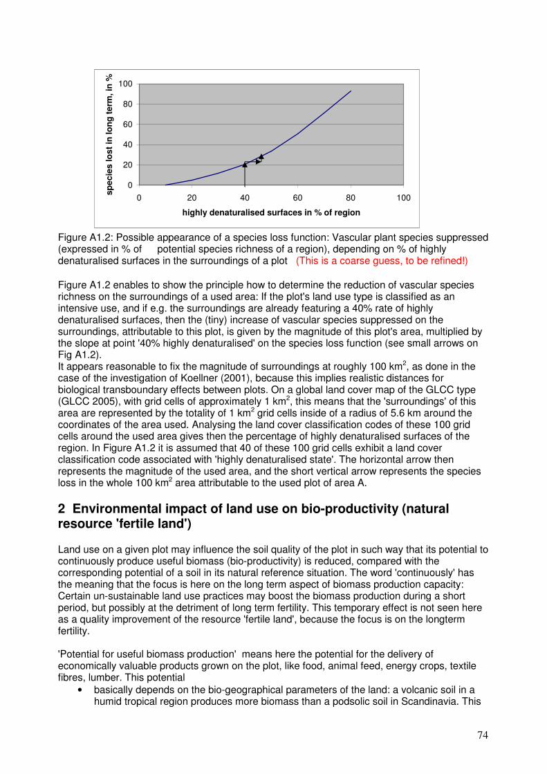
1. Present current research on land use impacts assessment (see Figure 1), 2. Form the basis for discussion in the workshop by introducing case studies.
With these aims, the document included the participants’ abstracts together with some guiding questions and exemplifying LCA case studies where land use impacts needed to be assessed. Figure 1 groups the presentations into the main themes showing some of the relationships between them.
Figure 1: Thematic map of the workshop presentations. Points for discussion and structure of presentations To work towards the recommendation of indicators for land use impacts, participants were encouraged to think in terms of how their contributions could be applied in practice in one of the following case studies. These case studies try to highlight the requirements for land use impact indicators related to:
− Different intensities of land use (see also the example by Cederberg, in section 4); − Different bio-geographical contexts; − Effects from different sectors.
4 Soil quality may be defined from a resource point of view (considering basically soil fertility for biotic production)
and from an ecological quality point of view (performance of other life support functions: filter and buffer;
substance cycling and storage; water infiltration; etc.).
9
Note that the case studies are only coarsely defined, as they are only intended to foster the discussion on likely requirements for the suggested indicators in typical LCA applications. Case A: land use impacts to produce 1 ton of soybean: assessment of one production system or comparison between alternative production systems:
• A1: intensive farming system in eco-region NA08055 (Central tall grasslands, USA). Yield: 2,800 kg ha-1year-1, only mineral fertilisers
• A2: organic farming system in eco-region NA08055 (Central tall grasslands, USA). Yield: 2,300 kg ha-1year-1, only organic fertilisers
• A3: intensive farming system in eco-region NT01355 (Madeira-Tapajós moist forests, Brazil), from cleared forest. Yield: 2,700 kg ha-1year-1, only mineral fertilisers
• A4: intensive farming system in eco-region NT01355 (Madeira-Tapajós moist forests, Brazil), from previously cropped land. Yield: 2,600 kg ha-1year-1, only mineral fertilisers
Case B: land use impacts to produce 1 GJ of thermal energy from different fuels: assessment of one production system or comparison between alternative production systems:
• B1: coal mine following ‘good mining practices’6 in eco-region AA08035 (Southeast Australia temperate savannah, Australia). 15 Mt coal 400 ha-1 year-1, lifetime: 40 years.
• B2: conventional coal mine in eco-region AA08035 (Southeast Australia temperate savannah, Australia). 15 Mt coal 400 ha-1 year-1, lifetime: 40 years.
• B3: intensive willow field in eco-region PA04025 (Atlantic mixed forests, Germany). Yield: 25 t ha-13year-1, 18 GJ t-1.
• B4: intensive willow field in eco-region PA12095 (Iberian sclerophyllous and semi-deciduous forests, Spain). Yield: 22 t ha-13year-1, 18 GJ t-1.
Case C: land use impacts to produce 1 m3 of pulpwood: assessment of one production system or comparison between alternative production systems:
• C1: FSC certified coniferous plantation in eco-region PA06085 (Scandinavian and Russian taiga, Sweden). Yield: 15 m3 ha-1 year-1.
• C2: old coniferous forest in eco-region NA05185 (North Central Rockies forests, Canada). Yield: 30 m3 ha-1 year-1.
• C4: Eucalyptus plantation in eco-region PA12095 (Iberian sclerophyllous and semi-deciduous forests, Portugal). Yield: 23 m3 ha-1 year-1.
Questions to address in the presentations The participants should think on the following practicalities for the application of their suggested indicators to one or more of these topical case studies, in order to guide the discussions:
1. What information would be required on the management system (e.g. which characteristics of ‘organic’ or ‘conventional’ systems need to be recorded in the Life Cycle Inventory, LCI)?
2. What information would be required on the eco-region where the land use occurs? 3. How does the magnitude of the proposed indicator vary dependent on the location of
landuse (NA0805 or NT0135 or AA0803…)? 4. How does the magnitude of the proposed indicator vary dependent on the management
system used (e.g. properly defined 'organic' or 'intensive')?
5 Defined from http://www.worldwildlife.org/wildfinder. The name of a suitable country is also provided to help
visualise the intended eco-region. Other sources for classification of bio-geographical zones can be discussed in the
workshop. 6 See http://www.goodpracticemining.org/.
10
5. How can we deal with cases where the location of the land use in LCI is imprecise (indication of continent or country only)?
6. How can we deal with cases where the land use management in LCI is not clear? 7. How can the suggested indicators be used for cross-comparisons between different land
use types (intensive vs. extensive agriculture; agriculture vs. mining; etc.) and across eco-regions to get to a result expressing the total impacts on biodiversity and soil quality?
8. Can the suggested indicators cope with the data limitations in developing countries? See for example the presentation by Kinuthia et al. (section 3 in this document) on indicators for biodiversity from a developing country perspective. Le Maitre7 argues that species composition / richness is not effective in developing countries due to lack of data, and it would possibly be more fruitful to work on region/sector specific keystone/ umbrella indicator species, as an approach which could be used by non-specialist.
These aspects should be addressed in each presentation. Sections 2-5 provide the abstracts of the sessions describing the LCA framework for land use impact assessment, soil quality indicators, biodiversity indicators, and other considerations and sector applications, respectively. Appendix 1 provides a worked example with real data sources on how a case similar to those described above could be applied for biodiversity impacts. Additionally, an example of how a possible indicator for soil quality could be applied for all these case studies is provided in Appendix 2, including a short discussion of the issues pointed above.
7 David Le Maitre (Conservation Biologist from Natural Resources and Environment, South Africa), personal
communication April 2006.
11
2. LCA Framework for Land Use Impact Assessment A framework for land use impact assessment in LCA8 (Milà i Canals et al.) Milà i Canals L
1, Bauer C
2, Depestele J
3, Dubreuil A
4, Freiermuth Knuchel R
5, Gaillard G
5,
Michelsen O6, Müller-Wenk R
7, Rydgren B
8
1 Centre for Environmental Strategy, University of Surrey, UK 2 Forschungszentrum Karlsruhe, Department for Technology-Induced Material Flows (ITC-ZTS), Germany 3 Institute for Agricultural and Fisheries Research - Animal Sciences - Fisheries, Belgium 4 Natural Resources Canada, Canada 5 Agroscope Reckenholz-Tänikon Research Station ART, Switzerland 6 Department of Industrial Economics and Technology Management, Norwegian University of Science and Technology (NTNU), Norway 7 Institut für Wirtschaft und Ökologie, Universität St. Gallen, Switzerland 8 Vattenfall Power Consultant AB, Sweden Land use by agriculture, forestry, mining, house-building or industry leads to substantial impacts, particularly on biodiversity and on soil quality as a supplier of life support functions. Unfortunately there is no widely accepted assessment method so far for land use impacts. This paper presents an attempt, within the UNEP-SETAC Life Cycle Initiative, to provide a framework for the Life Cycle Impact Assessment (LCIA) of land use. This framework builds from previous documents, particularly the SETAC book on LCIA (Lindeijer et al. 2002), developing essential issues such as the reference for occupation impacts; the impact pathways to be included in the analysis; the units of measure in the impact mechanism (land use interventions to impacts); the ways to deal with impacts in the future; and bio-geographical differentiation. The paper describes the selected impact pathways, linking the land use elementary flows (occupation; transformation) and parameters (intensity) registered in the inventory (LCI) to the midpoint impact indicators and to the relevant damage categories (natural environment and natural resources). An impact occurs when the land properties are modified (transformation) and also when the current man-made properties are maintained (occupation). The size of impact is the difference between the effect on land quality from the studied case of land use and a suitable reference land use on the same area (dynamic reference situation). The impact depends not only on the type of land use (including coverage and intensity) but is also heavily influenced by the bio-geographical conditions of the area. The time lag between the land use intervention and the impact may be large; thus land use impacts should be calculated over a reasonable time period after the actual land use finishes, at least until a new steady state in land quality is reached. Guidance is provided on the definition of the dynamic reference situation and on methods and time frame to assess the impacts occurring after the actual land use. Including the occupation impacts acknowledges that humans are not the sole users of land. The main damages affected by land use that should be considered by any method to assess land use impacts in LCIA are: biodiversity (existence value); biotic production potential (including soil fertility and use value of biodiversity); ecological soil quality (including life support functions of soil other than biotic production potential). Bio-geographical differentiation is required for land use impacts, because the same intervention may have different consequences depending on the sensitivity and inherent land quality of the environment where it occurs. For the moment, an indication of how such task could be done and likely bio-geographical parameters to be considered are suggested. The recommendation of indicators for the suggested impact categories is a matter of future research.
8 Abstract from the paper by Milà i Canals L, Bauer C, Depestele J, Dubreuil A, Freiermuth Knuchel R, Gaillard G,
Michelsen O, Müller-Wenk R, Rydgren B (2006): Key elements in a framework for land use impact assessment in
LCA. Int J LCA OnlineFirst DOI: http://dx.doi.org/10.1065/lca2006.05.250
12
How to transfer knowledge on species occurrence and soil quality into decision making9 (Müller-Wenk) Ruedi Müller-Wenk Institut für Wirtschaft und Ökologie, Universität St. Gallen, Switzerland Abstract: LCA aims at determining the effects on species occurrence and on the quality of soil, as originating from land use processes; in most cases these effects can be understood as differences to the baseline effects that would emerge from a natural or quasi-natural land area at the same geographical location as the used area. Introducing knowledge on biology and soil science into LCA is therefore an instrument for better respecting nature values in economical decision making. For practical modelling of land use effects on species occurrence in a given bio-geographical region, it is important to make available scientific data on expected species occurrence for each of the main land use types, as well as for quasi-natural lands. Biologists are expected to propose how to express species occurrence on a land area, and which set of species to be included in such counts. Further, data are welcome on the number of decades required for spontaneous renaturation of abandoned lands. A suggestion for the possible format of such data is proposed by the author. As LCA should be appropriate for land uses at any location on the globe, concepts are required that adapt the calculated magnitude of damage on the basis of data per bio-geographical region. For practical modelling of land use effects on fertile land as a natural resource, soil experts are expected to agree on how to express the magnitude of an area’s long-term potential to produce useful biomass. Is it preferable to define an appropriate set of soil parameters, or is it possible to fix a potential biomass yield under standard conditions? To model the damage on soil fertility originating from the most important land use types, the author submits to the experts a short list of damaging land use types, together with the corresponding fertility reduction per year. Here again, it is important to obtain data on the time needed for soil quality restore, if land with damaged fertility is abandoned. All of these data vary with the bio-geographical location of the used area; proposals are required for deriving soil fertility damage in less explored bio-geographical zones of the globe, starting from data on soil damage in better studied regions, as e.g. Central Europe or North America.
9 The full text of this contribution may be found in Appendix 1.
13
3. Indicators for Soil Quality Defining a framework to measure soil quality (Romanyà et al.) Romanyà J
1, Serrasolses I
2 & Vallejo R.V.
1,2
1 Universitat de Barcelona 2 CEAM. Centro de Estudios Ambientales del Mediterráneo. Soil provides a list of services to all users of terrestrial ecosystems and is crucial to our agricultural societies. From an anthropogenic point of view, soil quality may be then measured in terms of the services the soil provides to our society. The value of soil services to human societies has changed during history and thus the value we give to soils has also changed over time as it depends upon the economic and cultural basis of a society for a given context. While throughout history human awareness of the soil services has been mainly reduced to food, fibre and bioenergy production, nowadays the list of soil services has largely increased (see Table 1) and we are beginning to realise that soil management is no longer a local but a global issue affecting not only food and goods supplies but also to the human welfare and health. In other words, this societal awareness of the multiple functions of soils is not limited to an specific land use but to the whole landscape. Over the last century, as a result of the world increasing population and soil products demand, soil use has been intensified throughout the world and have promoted great scale changes in land use (agricultural land abandonment and urban sealing in good lands in developed countries and deforestation in developing countries). In developed countries increased forest land has been allocated to protect the environmental quality (e.g. water catchments, biodiversity conservation, C sequestration). However, forest soils in developed countries occupy less or much less than a 40 % of the land, and suffer a dramatic reduction in the developing countries. In consequence, some authors have recently stated that the protection of environmental quality and human health should be extensive to all land uses including productive land as well (see Foley et al., 2005). In this context, to our point of view, land management and planning should consider the ability of soils to function under different land uses, the reversibility of any land use change and the multifunctionality of soils (productivity, environment and human health). In consequence, the evaluation of soil quality should address holistically the following three principles across all soil uses:
1. Food security (quality and quantity) 2. Environmental quality and biodiversity 3. Human health and welfare
Although none of these principles is solely dependant on soils they are all very much related to soil functioning.
Soil quality assessment Soil quality assessment typically includes the quantification of indicators that are often derived from reductionist studies or general qualitative observations of the soil (Seybold et al., 1998). Overall, soil quality indicators condense the enormous complexity of the soil (Schjonning et al. 2004) in an attempt to describe the capacity of the soil to function. In spite soil quality indicators will not give a complete picture of the soil system we think they should attempt to cover, as much as possible, all soil functions relevant to human life although the relative weight of each one may change according to the land use and/or the environmental context. Thus, soil quality indicators should address the most relevant threats to soils in a given context and should be referred to their respective soil degradation thresholds. Soil degradation thresholds are specific to soil type and environmental conditions and should also cover all soil functions. In figure 1 we depict a framework for the establishment of soil quality indicators. Within this frame we first
14
define the general soil degradation thresholds and then at the local scale we also need to address the specificity of the land management impacts, and define the threats associated to a specific soil management. To do so we consider the management thresholds. According to Schjonning et al. (2004) management thresholds can be defined as the most severe disturbance any management may accomplish without inducing significant changes towards unsustainable conditions. These management thresholds must consider the soil type and environmental context that define the soil degradation context, may be specific to the soil use and management context, and may thus stress one of the general soil functions but not forget about the rest. In table 2 we present a list of selected indicators that are often used for assessing soil quality. In general these soil indicators are mainly related to soil productivity and only address the old threats to soils (erosion, salinisation, loss of organic matter, compaction …). These soil quality indicators hardly address the processes associated to the new threats to soil such as contamination. Soil contamination is a highly complex issue to cope with chiefly when we consider the multi-functionality of soils. Monitoring soil contamination can be addressed by risk analysis however, this type of analysis is not a straightforward methodology to be applied to soils as it includes toxicology studies for organisms (including humans) living in other environmental compartments. Under these circumstances, a conservative record list of soil inputs for traceability purposes should help assessing soil contamination issues. We think thus, that when assessing soil contamination issues we should consider that the soil quality indices monitoring the intrinsic soil function are not going to be comprehensive for many of the soil contamination processes as they do not account for the effects of the pollutants transferred to other environmental compartments. References Foley J.A., DeFries R., Asner D.F., Barford C., Bonan G., Carpenter S.R., Chapin F.S., Coe M.T., Daily
G.C., Gibss H.K., Helkowsky J.H., Holloway T., Howard E.A., Kucharik C.J., Monfreda C., Patz J.A., Prentice C., Ramankutty N. and Snyder P.K. 2005. Global consequences of land use. Science. 570-574.
Karlen D.L., Mausbach M.J., Doran J.W., Cline R.G., Harris R.F. and Schuman G.E. 1997. Soil quality: a concept, definiton, and framework for evaluation. Soil Science Society of America Journal 61: 4-10.
Schjonning P., Elmholt S. and Christensen B.T. 2004. Soil quality management. Concepts and terms. In: Schjonning P., Elmholt S. and Christensen B.T. (eds.). Challenges in modern agriculture. CAB International. pp 1-15.
Seybold C.A., Mausbach M.J., Karlen D.J. and Rogers H.H. 1998. Quantification of soil quality. In: Lal R., Kimble J.M., Follet R.F. and Stewart B.A. (eds.). Advances in Soil Science CRC Press. Boca Raton. Florida pp. 387-404.
15
Table 1. List of main soil services.
Soil services to human society Major concerns
1. The base for terrestrial primary production (agriculture and forestry)
Productivity
2. Regional climate and air quality regulation (carbon sequestration)
Environment
3. Regulation of water quality and supply
Environment
4. Habitat for many organisms (biodiversity)
Environment
5. Natural system to recycle organic matter and nutrients and to prevent pathogen dispersion (purifying capacity)
Environment
& Human Health
Table 2. Selected indicators of soil quality and some processes they impact (adapted from Karlen et al., 1997).
Measurement Process affected
Organic matter Nutrient cycling, pesticide and water retention, soil structure Infiltration Runoff and leaching potential, plant water use efficiency, erosion
Figure 1. Framework for establishing soil quality indicators.
17
Land use type and indicators affecting land degradation and desertification (Kosmas) C. Kosmas Agricultural University of Athens, Laboratory of Soils and Agricultural Chemistry, Iera Odos 75, Athens, Greece 11855 The necessity of elaborating indicators is one of the priorities identified by the United Nations Convention to Combat Desertification (UNCCD). Indicators generally simplify reality to make complex processes quantifiable so that the information obtained can be communicated. The identification of valid indicators ensure the most effective use of limited data provided by monitoring systems. According to Paperdick and Parr (1992) and Rodale Institute (1991), defining indicators of soil quality is a complicated issue since multiple functions of soil in maintaining productivity and environmental well-being have to be integrated with physical, chemical and biological soil attributes. Soil quality is related to the stage of land degradation. An analysis have been conducted using a series of 53 indicators related to the soil, topography, vegetation, climate, social, economic, and management characteristics for defining soil quality and stage of land degradation and desertification (Table 1). These indicators are mainly related to the specific local characteristics at farm level such as soil depth, soil texture, drainage, slope gradient slope exposure, rainfall, aridity index, family status, land tenure, present and previous types of land use, period of existing type of land use, plant cover, application of fertilizers and pesticides, tillage operations, tillage depth and direction, water availability, water quality and quantity, sustainable farming, soil erosion control measures, controlled grazing, soil water conservation, subsidies, etc. The selected indicators can be easily found on existing regular survey reports on soil, vegetation, climate, land management, etc. Based on existing classification systems such as the geo-referenced database, classes have been defined for each indicator and presented in a tabulated form. Classes have been defined for each indicator and numbers have been assigned for each class according to its importance on desertification. The study was conducted (a) in hilly areas in which the main process of land degradation was soil erosion, and (b) in plain areas located along the coast where the main process of land degradation was soil salinization. In collaboration with the land user, data were collected for the selected indicators from 428 field sites under various types of land use (olive groves, vineyards, cereals, pastures, pine and oak forests, and natural vegetation) and management practices located at various areas of Greece. The stage of land degradation was defined at each field site by defining type of environmentally sensitive areas (ESAs) to desertification (Kosmas et al., 1999) and degree of soil erosion. A principal component and a stepwise statistical analysis were conducted for all indicators separately for each land use type and the sensitivity of each indicator to land degradation and desertification was identified. Algorithms were defined for each land use type that can be easily used for identifying land degradation and desertification risk at farm level. The obtained data showed that indicators related to the social characteristics such as family size, land ownership, farmer age, farm size, parallel employment are highly variable among various areas and types of land use. The analysis of the data showed that the most important indicator for defining land degradation and desertification risk in all study land use types was annual rainfall. Other important indicators commonly identified for the land use types analyzed in which soil erosion was the main process of land degradation were soil depth, slope gradient, slope aspect, rock fragment content at the soil surface, and policy enforcement of the existing regulations for protection of the environment. Indicators related to land management such as tillage operations, tillage depth, controlled grazing, period of existing land use type, erosion control measures, etc. were mainly important for olive groves, cereals and pastures. Indicators related to land characteristics for pine and oak forested areas are mainly related to land characteristics such as soil depth, slope gradient, slope exposure, aridity index, plant cover, etc.
18
The analysis of data for areas in which the main process of land degradation and desertification was salinization, showed that the most important indicators were ground water depth, drainage, water quality, frequency of flooding, distance from the seashore, type of land use, rainfall etc. The used indicators requires further analysis for defining interrelations among them and reducing to a low cost, efficient and reasonable number for highlighting land degradation and desertification to a full range of land users. As an example of using the analyzed indicators for defining land degradation and desertification risk of a certain piece of land under various scenarios of land use and applying typical land management practices is given in Fig. 1. Among the various land use types pastures and vines generate the highest risk of degradation. The risk of degradation decreases in the order of pastures-vines-pines-cereals-olives-oak forests.
References Kosmas, C., Kirkby, M. and Geeson, N. 1999. Manual on: Key indicators of desertification and mapping
environmentally sensitive areas to desertification. European Commission, Energy, Environment and Sustainable Development, EUR 18882, 87 p.
Paperdick , R.I. and Parr, J.F., 1992. Soil quality – the key to a sustainable agriculture. Am. J. Altern. Agric. 7:2-3.
Rodale Institute, 1991. Conference report and abstracts, Int. Conf. On the Assessment and Monitoring of soil quality. Emmaus, PA. 11-13 July 1991. Rodale press, Emmaus, PA.
UNEP, 1992. World atlas of desertification. United Nations Environment Programme. London: Edward Arnold.
19
Table 1. Indicators and corresponding values the linear regression model (beta values) for the assessment of desertification risk (DR) in the various land use types
Land use type No Indicators Cereals Olives Vines Pastures Pines Oaks Salt-affected
1 Land ownership -0.55 -0.44 2 Farm size 3 Parcel size 0.39 4 Family size 5 Farmer age 5 Number of parcels. -0.68 7 Par. employment 8 Farmer age 0.40 9 Subsidies 10 Tillage operations 1.57 0.73 11 Tillage depth 12 Tillage direction -0.15 -0.32 13 Application of fertilizers 14 Number of animal 0.09 15 Present land use -0.25 16 Previous land use 0.71 17 Period of existing land use -0.68 -0.54 18 Plant cover -0.40 -0.56 -0.50 19 Soil depth -0.11 -0.56 -0.62 -0.83 20 Slope gradient 0.44 0.98 0.31 0.38 0.39 21 Drainage 0.23 22 Soil texture 0.22 -0.32 23 Parent material 0.19 0.47 0.17 24 Rock fragments -0.26 -0.54 -0.38 -0.53 25 Rainfall -2.94 -0.79 -0.48 -2.26 -1.81 -1.16 26 Annual air temp. 27 Summer air temp. 28 Aridity index 0.28 1.13 29 Slope exposure 0.67 0.41 0.65 1.09 30 Elevation -0.29 31 Seashore dist. 32 Water available 33 Water quality -0.11 34 Water quantity 0.14 35 Ground water depth -0.35 36 Ground water recharge 37 Frequency of flooding 0.65 -0.26 0.33 38 Sustainable farming 0.69 39 Presence of terraces 0.13 40 Protection of terraces 41 Controlled grazing -0.44 0.20 42 Crop water requirements 43 Storage of water runoff 44 Reclamation of affected soils -0.41 45 Erosion control measures -0.23 46 Forest fire protection -0.65 47 Fire risk 48 Soil organic matter increase 49 Reclamation of mining areas 50 Soil erosion protection 51 Drought resistance 52 Land use intensity 3.31 53 Policy enforcement 1.03 0.44 0.83 0.10 0.77 0.84
Table 2. Definition of desertification risk based on the type of environmentally sensitive area (ESA) and the degree of soil erosion. Type of ESA Degree of soil erosion Desertification risk
Very severe, severe, moderate High Critical Slight, no erosion Moderate Very severe High Severe, moderate Moderate
Fragile
Slight, no erosion Low Very severe, severe Moderate Potential Moderate, slight, no erosion Low
Non-threatened Any degree of erosion No risk
Figure 1. Estimated land degradation and desertification risk (DRI) for a certain piece of land under various land use types.
Pasture Vines Pines Cereals Olives
Oaks
0
1
2
3
4
5
6
7
8
DRI
Land use
21
Bacterial community structure as indicator of quality changes in Brazilian soil: Integrating molecular based soil microbial diversity data into a soil quality analytical framework (Rosado et al.) Rosado A.S.
1, Countinho H.L.C
2, Aboim M.C.R.
1, Franco N
1, Peixoto R.S.
1
1 Institute of Microbiology, Federal University of Rio de Janeiro, Rio de Janeiro, Brazil 2 Embrapa Solos, Rua Jardim Botânico, Rio de Janeiro, Brazil
Soil quality is obviously a concept in constant development, and it is foreseeable that this will remain so for some time to come. The “Global Assessment of Soil Degradation” (GLASOD)-study reported human-induced soil degradation processes resulting in soil erosion by water and wind, and soil physical and chemical deterioration (Oldeman, 1994). Soil degradation processes and the degree to which yield losses occur in various soils are a function of interacting factors, including soil physical, chemical and biological properties. To get a handle on such processes, researchers have set out to develop and apply indicators of soil quality. Indicators should ideally reflect ecosystem processes, be accessible to many users and applicable to field conditions, and be sensitive to variations in management and climate (Kennedy and Smith, 1995). Since soil quality is strongly influenced by microbe-mediated processes, and function can be related to diversity, it is likely that microbial community structure will the potential to serve as an early indication of soil degradation or soil improvement. In despite of the vast majority of micro-organisms has proved refractory to cultivation, the recent developments in molecular biology based techniques have led to rapid and reliable tools to characterize microbial community structures and to monitor their dynamics under in situ conditions. Soil microbial diversity potentially harbours the most sensitive soil quality indicators, but their use is hampered by difficulties in the analysis and interpretation of the data, especially when obtained by molecular biology techniques. Soil bacterial community structure can be used as early indicator of alterations in soil conditions induced by land management, when compared to other methods. Thus, analysis of microbial communities could provide data to elucidate the links between soil biotic and abiotic factors. The extent of the diversity of micro-organisms in soil is seen to be critical to the maintenance of soil health and quality, and it is known that the treatment or management of soil affects microbial community structures (Peixoto et al., 2006) Since the soil quality concept encompasses not only productivity, but also environmental quality and land use, the changes in soil with perturbations need to be fully described to assist in the rebuilding or maintenance of an ecosystem. Although ecosystem functioning is governed largely by soil microbial dynamics, microbial populations and their responses to stresses have been traditionally studied at the process level, in terms of total numbers of micro-organisms, biomass, respiration rates, and enzyme activities, with little attention being paid to responses at the community level (Kennedy and Smith, 1995). Our objective was to assess the effects of different tillage systems on soil bacterial community structure, using two molecular markers (16S rRNA and rpoB genes), total organic carbon (TOC) and aggregate size and stability properties, while evaluating their performance as early indicators of soil quality. Soil bacterial community structure analysis, based on denaturing gradient gel electrophoresis of polymerase chain reaction amplified DNA (PCR/DGGE) using two different genes as biomarkers, 16S rRNA (fig.1 and 2) and rpoB genes, showed that the different soil management systems selected specific dominant populations. The molecular profiles were most similar between samples from the no-tillage system and secondary forest, compared to samples from conventional tillage. Soil bacterial community structure was better early indicator of alterations in soil conditions induced by conversion to the no tillage system, when compared to total soil carbon and other soil physical attributes (Peixoto et al., 2006). We also present a soil quality analytical framework based on the integration of chemical, physical, microbiological, and molecular biology (PCR/DGGE) data. This framework was applied to a mosaic of land uses distributed in an agricultural landscape located in a mountainous area of the Atlantic Forest in Southeast Brazil. The results demonstrated the applicability of the soil
22
quality analytical framework proposed, and revealed that traditional shifting cultivation practices in the studied area are compatible with conservation of soil quality, provided that the fallow periods are maintained longer than 5 years (Aboim et al., in preparation). Currently, stricter environmental laws that prevent farmers from cutting Atlantic Forest trees are leading them to reduce or eliminate the fallow periods. The results are significant reductions in soil aggregation indices and organic carbon contents, greater impacts on the bacterial community structure, with potential disruption of soil based ecosystem functions, such as erosion control, carbon sequestration, and hydrological regulation. References: Kennedy, A.C., Smith, K.L., 1995. Soil microbial diversity and the sustainability of agricultural soils. Plant Soil 170, 75-86. Oldeman, L.R., 1994. The global extent of soil degradation. In: Soil resilience and sustainable land use Greenland, D.J., Szabolcs, I. (Eds.). CAB International, Wallingford, pp. 99-118. Peixoto, R. S., Coutinho, H. L., Madari, B., Machado, P., Rumjanek, N., Seldin, L., Elsas, J. D. V., Rosado, A. S. 2006. Bacterial community structure and soil aggregation as indicators of quality changes in a Brazilian Cerrado soil. Soil & tillage research. ( in press -Available online).
Figures:
,0
Figure 1. DGGE banding pattern of 16S rDNA PCR amplification of soil samples (A, 0-5cm depth, B, 5-10 cm depth): L, marker (from top to bottom Staphylococcus aureus MB, Bacillus subtillis IS 75, Escherichia coli HB101); TW-Tillage with winter cover crop; T- Tillage without winter cover crop; NTW-no tillage with winter cover crop; NT-no Tillage without winter cover crop; F-Native forest; 1-First sampling; 2-Second sampling.
L TW1 TW2 T1 T2 NTW1 F2 NT1 NT2 F1 NTW2 L
A B
L TW1 TW2 T1 T2 NTW1 NTW2 NT1 NT2 F1 F2 L
23
Linkage Distance
F2/5-10 F1/5-10 F2/0-5 F1/0-5
NT2/5-10NT1/5-10
NTw2/5-10NTw1/5-10
NT2/0-5 NT1/0-5
NTw2/0-5NTw1/0-5
T2/5-10 T1/5-10
Tw2/5-10Tw1/5-10
T2/0-5 T1/0-5
Tw2/0-5 Tw1/0-5
0 2 4 6 8 10
Figure 2. Inferred similarity of dominant bacterial community structure using 16S rDNA-DGGE profiles after cluster analysis with Ward and Pearson correlation coefficient. TW-Tillage with winter cover crop; T- Tillage without winter cover crop; NTW-no tillage with winter cover crop; NT-no Tillage without winter cover crop; F-Native forest; 1-First sampling; 2-Second sampling; 0-5 and 5-10 cm depth.
24
Impact of forestry on soil quality in the UK (Vanguelova et al.) Vanguelova E
1, Moffat A
1 and Lynch J
1
1 Forest Research, Alice Holt Lodge, Farnham, GU10 4LH Introduction Woodland in the UK covers 2.8 million hectares (Forestry Commission, 2005). Of this total, 1.3 million hectares (47%) is in Scotland, 1.1 million hectares (40%) is in England, 0.3 million hectares (10%) is in Wales and the remaining 0.1 million hectares (3%) is in Northern Ireland. The 2.8 million hectares of woodland in the UK represents 11.6% of the total land area, although this percentage ranges from 6.3% in Northern Ireland to 17.1% in Scotland. This proportion is amongst the lowest in Europe (only Ireland and the Netherlands have smaller percentages), but the productivity of Britain's forests is substantially higher than much of Europe owing to our plantation-based forest estate and long growing season. Soil quality is of significant importance for: (1) the productivity and sustainability of forest systems, (2) the conservation of soil and water resources, (3) the accumulation of persistent toxic substances, and (4) the contribution forested systems make to the global carbon cycle. Despite an embedded culture which acknowledges the importance of soil in the forest industry, it has been recognised that there is a need to monitor its `state` so that forest practices can be modified should negative and irreversible changes begin to occur. The concept of ‘soil quality indicator’ has been put forward as an appropriate means to establish a baseline of soil quality and / or functional ability, and from which changes can be observed as a result of pressures exerted on the soil (Moffat and Kennedy, 2002).
Forest soil quality baseline Historically, forest plantations have been located on comparatively infertile, poorly drained or thin soils in Britain. At a national scale a disproportionate amount are found on gleys and peats, but locally, individual forests tend to occur on the poorest soils in the region. In addition, many types have presented pedological impediments to deep rooting, especially the ironpan and fragipan soils. A consequence of this soil geography is that twentieth century forestry was dominated by the need to conquer the ground and bring it into a state fit for forest establishment, and promote economically satisfactory growth. Drainage was achieved principally by forming an open ditch network, and soil cultivation took place mainly by ploughing. Deep subsoiling was used to break up ironpans where necessary (Moffat and Kennedy, 2002). Cultivation affects soil conditions and functions such as effects on soil and air temperature, soil moisture, nutrients and bulk density (Paterson and Mason 1999). The effects above are regarded by foresters as beneficial and likely to improve tree survival, growth and stability, but cultivation can also promote negative effects such as erosion and nutrient loss. The soil’s ability to sequester carbon may also be compromised. The effects of these practices on the water environment were appreciated in the 1980s and current guidance (Forest and Water Guidelines, 2003) is far more restrictive in advocating minimal and shallow cultivation wherever possible. Changes in forest soil quality through forest life cycle and forest practices Using land for forestry gives little flexibility for changing the land use in short term compared to annual agricultural cropping systems. Changes to soil properties and functioning are also caused by the growth of trees themselves, notably in the first rotation after agriculture. Interception of precipitation by conifer canopies is larger than grass and most other agricultural crops. Thus, these soils tend to be at field capacity for a shorter time than those under agriculture. In peat soils and some gleys, tree crops may cause irreversible shrinkage and cracking, leading to altered hydrological behaviour (King et al., 1986). Chronosequence studies
25
develop our understanding of the natural tree growth cycle changes which are essential to enable the interpretation of any soil quality indicators (Pitman and Vanguelova, 2005).
Forest development influences soil properties with time, which is also highly dependent on the initial choice of tree species and the forest management practiced during the forest life cycle. Commercial forest practices in the UK developed predominantly within the plantation sylvicultural system, and management interventions to extract timber can be very disruptive (clear felling, whole tree harvesting practices) and can undoubtedly affect the quality of the forest soils (Wood et al., 2003). Practicing whole tree harvesting, for example, threatens the new rotation from soil nutrient exaction and reduced growth. Long-term experimental research has shown that even brash retention or subsequent fertilisation are sometime not adequate to sustain second rotation growth on whole tree harvesting sites on poor soils (Harrison, 2005). Wood extraction itself, if performed unprofessionally, can impact on the physical soil properties by causing compaction and rutting, especially on sensitive soil types (Hutchings et al., 2002). Over one half (53%) of the total woodland area in Great Britain is made up of conifers although this proportion ranges from 31% in England to 72% in Scotland. Sitka spruce accounted for almost one half (49%) of the conifer area, followed by Scots pine (16%) and Lodgepole pine (10%). Amongst broadleaf species, oak covered 23% of the broadleaf area, followed by birch (16%) and ash (13%). Coniferous trees and their litter acidify the soil with time compared to most broadleaved trees. Increase in soil acidity is associated with changes in other soil processes and fluxes such as N and C cycling and pools, microbial activities and communities, organic matter, decomposition rate, Al and heavy metal mobilisation (Vanguelova, et al. 2005, Pitman and Vanguelova, 2005). In response to increasing environmental awareness from the public, forest policy is encouraging less intensive practices which increase species and structure diversity in existing even-aged plantation forestry to promote and provide multi-purpose benefits, for example Continuous Cover Forestry (CCF) practice. At a policy level CCF is expected to have a more benign impact on the environment compared to clearfelling due to the smaller-scale nature of the management operations. Nevertheless, there are some areas of concern, as one of the main threats is thought to be the potential increase in risk of soil compaction, rutting and erosion linked to more frequent machine access and lack of brash to protect routeways during wood extraction (Ireland et al., 2006). Plantations on Ancient Woodland Sites (PAWS), designated to convert conifer plantations back to semi-ancient broadleaf woodland, will influence soil quality in different ways, depending on the technique coniferous brash is managed. If the brash is removed off site, a substantial amount of nutrients are removed with it. On the other hand, leaving conifer brash on sites being restored to broadleaved woodland could cause problems such as soil eutrophication due to increased rates of mineralisation and nitrification and also soil acidification due to the acidic nature of the brash.
Intensive agriculture and farming activities influence forest soil properties especially in small woodland patches, which are particularly common in England, through their effect on nitrogen deposition and nitrogen cycling which is enhanced at the forest edge (Sutton et al., 2001, Vanguelova, 2005). Impact of environmental drivers on forest soil quality In addition to forest management practices, changes in the environmental conditions due to human activities threaten the ability of soil to provide the necessary function for forests. Types of soil damage associated with atmospheric deposition, of particular concern in forests, include soil acidification, nutrient imbalance, nitrogen enrichment (eutrophication) and heavy metal contamination. Soil vulnerability is mostly based on soil characteristics such as soil chemical status, including pH, base saturation, Acid Neutralising Capacity (ANC), Cation Exchange Capacity (CEC), as well as the parent material. Several soil chemical indicators (e.g. soil pH,
26
organic matter content, C/N ratio) have been proposed in the UK by the Forestry Commission (Moffat and Kennedy, 2002, Moffat, 2003) and in Europe by the Ministerial Conference on the Protection of Forests in Europe (MCPFE, 1998) to be used to monitor forestry practices and potential effects of environmental changes on soil quality. There is a good evidence that acid deposition has resulted in acidification of acid sensitive forest soils, but evidence is limited which relates soil acidification to impacts on soil function and /or tree vitality. Sulphur deposition has decreased and a slow recovery is observed in some forest soils, but nitrogen deposition has not and nitrogen is now of most concern, both for its role in acidification and eutrophication of forest soils. Changes of climate will directly and indirectly affect forest soil quality and function. Rising temperatures can accelerate mineralisation rates and soil nutrient availability but nutrient and dissolved organic carbon leaching may also occur due to heavy winter rainfall. All effects will have implications for nutrient and carbon imbalances in forest soils. Soil moisture deficit may occur in sensitive areas following reduction in precipitation. Soil nutrient pools can be affected by changes in the amount and quality of tree litter production. Physical soil disturbances may occur as a result of winter waterlogging and windthrow as the size and proportion of storm events increases.
Biodiversity The different physiochemical properties of forest soils compared with agricultural soils result in different patterns of biodiversity. In particular the tree rhizosphere population can be characterised by an extensive network of ectomycorrhiza which effectively extend the water and nutrient absorbency network of the tree root system although in the early stage of tree establishment endotrophic mycorhiza, are also important (Lynch, 1990). These symbionts, together with the asymbiotic bacteria fungi and protozoa contribute to the net carbon and nutrient cycling in the soil ecosystem. As rhizodeposition to these populations can account for up to 40% of the carbon sequestered by the plant, the rhizosphere population becomes an important pool of the global carbon balance. Most of our knowledge of nitrogen and mineral cycling through the rhizosphere biota comes from studies of agricultural soils, but clearly it is important to assess those pathways in forest soils. Such assessments become crucial inputs to life cycle analysis of the plant production system in soil. Molecular methods are used increasingly to make these assessments (Lynch et al, 2004).
Conclusion Forest soils differ from agricultural soils with: 1) well developed organic layers, 2) much higher acidity, 3) higher organic matter content, and 4) large spatial variability, 5) different biotic balances. These main differences need to be always considered when evaluating and selecting indicators to inform on the quality of forest soils. In order to determine the soil indicators and their thresholds to be used effectively in soil and forest management sustainable practices, some primary requirements need to be met as a) indicators should be sensitive to anthropogenic changes, b) indicators should be easy and cost effective to measure, c) they have been measured already or can be measured in most soil monitoring networks, d) indicators should provide a response to disturbances that is distinct from natural variation and e) indicators should be able to provide diagnostic and prognostic information and/or be able to be included in both aspects. Due to the variability and diversity of the forest ecosystems as well as the variability in environmental changes and forest management practices and their impacts on different soil quality, it is still not possible to state one or a single simple indicator to express the soil quality influenced by land use for forestry. Nevertheless, current and future research work is intended to improve our ability to use soil indicators as a means on influencing environmental and forestry policy and practice.
27
References Forestry Commission 2003. Forests & water guidelines. 4th edn. Forestry Commission, Edinburgh. Forestry Commission 2005. Forestry Facts & Figures 2005. Economics and Statistics, Forestry Commission, Edinburgh. Harrison, A.J. 2005. Whole-tree harvesting experiments. Annual report to Forestry Group, Forestry Commission. Hutchings, T.R., Moffat, A.J. and French, C.J. 2002. Soil compaction under timber harvesting machinery: a preliminary report on the role of brash mats in its prevention. Soil Use and Management, 18, 34-38. Ireland, D., Nisbet, T. and Broadmeadow, S. 2006. Environmental Best Practice for Continuous Cover Forestry. Environmental Agency Research Report (in press). King, J.A., Smith, K.A. and Pyatt, D.G. 1986. Water and oxygen regimes under conifer plantations and native vegetation on upland peaty gley soil and deep peat soils. Journal of Soil Science 37, 485- Lynch, J.M. (Ed) (1990). The Rhizosphere, John Wiles, Chichester. Lynch, J.M., Benedetti, A., Insam, H., Nuti, M.P., Smalla, K., Torsvik, V. & Nannipieri, P. (2004). Microbial diversity in soil: ecological theories, the contribution of molecular techniques and the impact of transgenic plants and transgenic microorganisms. Biology and Fertility of Soils, 40, 363-365. MCPFE 1998. Ministerial conference on the protection of forests in Europe. 2,3,4 June 1998, Lisbon, Conference Proceedings. Ministry of Agriculture, Rural Development and Fisheries, Liaison Unit, Lisbon. Moffat, A.J. and Kennedy, F. 2002. Indicators of soil quality for UK forests. In: Loveland, P.J. and Thompson, T.R.E. (eds), Identification and development of a set of national indicators for soil quality. Environmental Agency Research & Development Project Record P5-053/PR/02, 77-104. Moffat, A.J. 2003. Indicators of soil quality for UK forestry. Forestry76, 547-568. Paterson, D.B. and Mason, W.L. 1999. Cultivation of soils for forestry. Forestry Commission Bulletin 119. Forestry Commission, Edinburgh. Pitman, R. and Vanguelova, E. 2006. Influences of stand age and soil properties on forest biodiversity. In: Forest Research Annual Report and Accounts 2004–2005. The Stationery Office, Edinburgh. Sutton M. A., Tang Y. S., Dragosits U., Fournier N., Dore T., Smith R. I., Weston K. J. and Fowler D. 2001. A spatial analysis of atmospheric ammonia and ammonium in the UK. The Scientific World 1 (S2), 275-286. Vanguelova E.I., Nortcliff S., Moffat, A.J. and Kennedy, F. 2006. Short-term effects of manipulated increase in acid deposition on soil, soil solution chemistry and fine roots of Scots pine (Pinus sylvestris) stand on a podzol. European Journal of Soil Science (submitted). Vanguelova, E.I. 2005. Preliminary study on soil N spatial variability along transects under Corsican and Beech forest stands. Internal Forest Research Report. Wood, M.J., Carling, P.A. and Moffat, A.J. 2003. Reduced ground disturbance during mechanised forest harvesting on sensitive forest soils in the UK. Forestry, 76 (3), 345-361.
28
4. Indicators for Biodiversity Biodiversity indicators for impact assessment: moving targets in a changing world (Treweek et al.) Jo Treweek
1, Phillip Bubb
2
1 International Association for Impact Assessment’s ‘Capacity Building for Biodiversity and Impact Assessment’ (IAIA-CBBIA) Program. 2 World Conservation Monitoring Centre (WCMC), Cambridge Biodiversity is an essential and integral part of healthy environments: if too much biodiversity is lost, many essential environmental services, currently seen as a ‘free good’, will be undermined (Constanza et al., 1997). Biodiversity is therefore increasingly being measured in terms of the services it provides to people, so that the benefits of biodiversity are recognized and accounted for in policy development. At the World Summit on Sustainable Development (WSSD) in 2002, world leaders committed to a set of goals that promote human development as the key to sustaining social and economic progress. Termed the Millennium Development Goals, they set a framework of targets that the world must achieve by 2015, focusing on poverty alleviation, health, education and gender equity. Achievement of most, if not all of the Millennium Development Goals is intextricably linked with healthy and biodiverse ecosystems. People rely directly or indirectly on biodiversity to obtain: • Crops and food. • Medicines. • Building materials. • Fuel. • Tools. • Spiritual needs. • Environmental services (e.g. clean water, fertile soil, clean air).
The state of the world’s ecosystems have recently been assessed in detail by an international team of experts under the Millennium Ecosystem Assessment – MEA (2005), who concluded that “Human actions are fundamentally, and to a significant extent irreversibly, changing the diversity of life on Earth, and most of these changes represent a loss of biodiversity. Changes in important components of biological diversity were more rapid in the past 50 years than at any time in human history”. It is therefore increasingly important to recognize when loss of biodiversity units (different genes, species), declines in their abundance (eg population decline of a key pollinator due to pesticide use) or changes in their structural organization (eg fragmentation of habitat) might cause deterioration or collapse of ecosystems and the services they provide. A growing number of ecosystems are believed to be approaching critical thresholds or ‘tipping points’ beyond which they are unable to recover their functionality and productivity. The consequences of biodiversity loss are often hard to recognize in the short term and on a case-by-case basis. The real costs to society are often much higher than expected and are discovered too late for effective remedial action to be taken. We need early warning indicators of cumulative change and irreversible damage to avoid major economic ‘surprises’ in the longer term. Biodiversity indicators are quantified information on biotic or abiotic features that reflect the state of an ecosystem, habitat or other components of biodiversity. A widely used conceptual framework for use of indicators is the Pressure-State-Response (PSR) framework (Figure 1), developed by the Organisation for Economic Cooperation and Development (OECD 1993) to aid analysis of the causes of change in the natural environment and the response measures of human society to these changes. Subsequently a variety of variations of this framework have
29
been developed including the now widely used Driving Force – Pressure – State – Impact – Response (DPSIR) framework (Rigby et al. 2000). The Pressure component requires identification of factors potentially affecting a particular biodiversity feature, influencing its state. Examples might be abstraction of water for crop irrigation or conversion of land for development of housing. The state of biodiversity may be affected by specific pressures that are being assessed and also a range of other influences (collectively referred to as cumulative effects). All these need to be taken into account. Impact assessments need to define the state of biodiversity in the absence of a proposed change (‘baseline’) and following the proposed change: will this alter the state of biodiversity significantly, or result in loss of important values or services? The Response component requires outcomes for biodiversity to be appraised in relation to any policies, laws and activities that have been implemented to manage and conserve biodiversity and to suggest ways in which desired outcomes can be achieved. This might be through adaptive policy responses or through mitigation intended to reduce or offset significant adverse effects on biodiversity. In this framework, state, pressure and response indicators are basically linked to a cause-effect chain for a given situation or problem, which could be established using data generated through a process of Life Cycle Assessment. However what this framework fails to capture is the concept of a ‘desired’ endpoint or state. An additional role of indicators in such a framework might be to define such a state or enable assessment of progress towards such a state. However, biodiversity is dynamic: the goalposts are constantly moving and there is a tendency to manage to a limit and then lower the threshold of acceptable change to accommodate the losses that have occurred in order to reflect the reality of current conditions. This means that continuing losses of biodiversity are likely. How can this trend be reversed, in order to achieve the 2010 target of ‘no net loss’? Many measures of diversity have been developed. These have proved difficult to carry across into assessment processes or policy development, because they are difficult to link directly to biodiversity values and levels of service-provision. Indicators are purpose-dependent and should always be presented together with an explanation of their application. It is therefore doubtful whether it is possible, or even appropriate, to identify generic indicators which might be applicable in any situation. The process of deriving suitable indicators in any particular situation might be more important than the robustness of indicators themselves. For biodiversity, scientifically defensible indicators are not possible to derive without access to reliable and up to date information on biodiversity distribution and state. Global coverage is patchy and there is much critical biodiversity which is unrecorded and officially unrecognised, featuring more in local folk lore and tradition than in official databases. This presentation will review some biodiversity indicators that have been used to link land use change and biodiversity and discuss the challenges associated with their application References Constanza R, et al., (1997) The Value of the World’s Ecosystem Services and Natural Capital, Nature, vol 387, pp 253-260, London Millennium Ecosystem Assessment 2005. Ecosystems and human well-being: Biodiversity synthesis. World Resources Institute, Washington, D.C. OECD 1993. OECD core set of indicators for environmental performance reviews. Organisation for Economic Cooperation and Development, Paris. Rigby, D., D. Howlett, and H. L. Woodhouse. 2000. Sustainability indicators for natural resource management and policy: a review of indicators of agricultural and rural livelihood sustainability. University of Manchester, Manchester, UK.
30
Box 1 Biodiversity is: “The variability among living organisms and the ecological complexes of which they are part, including diversity within species, between species and of ecosystems” In other words it is the ‘variety of life’. The Convention on Biological Diversity (CBD) encourages consideration of biodiversity at three main levels: the gene level (diversity within species); the species level (diversity of or between species) and the ecosystem level (the diversity of life within a defined system). Impacts on biodiversity can be assessed on the basis of:
• what different types of biological units or building blocks are present at each of these levels and how many there are (abundance).
• how these units are arranged in space and time (structure). • how they interact and operate to make a living system (function)
www.biodiv.org Box 2 Ecosystem and biodiversity services provided for humankind (adapted from MEA, 2005) * Indicates services that are degraded Provisioning Services
• Food a. Crops b. Livestock c. Capture fisheries* d. Aquaculture e. Wild plant and animal products*
Regulating services • Air quality regulation* • Climate regulation • Water regulation • Erosion regulation* • Water purification* • Disease regulation • Pest regulation* • Pollination* • Natural hazard regulation*
Cultural services
• Cultural diversity • Spiritual and religious values* • Knowledge systems • Educational values • Inspiration • Aesthetic values* • Social relations • Sense of place • Cultural heritage values • Recreation and tourism
Supporting Services
• Soil formation • Primary production • Nutrient cycling • Water cycling
31
Figure 1. The Pressure – State – Response framework
Figure 2
Unexploited Target
Increasing human impact or
intervention……………………
Precautionary Limit
Reference directions
(loss or gain of biodiversity)
Pressures on
biodiversity
State of biodiversity
(assess baseline and following a
proposed change)
Response
MONITOR
Impacts (may be
generated by
‘driving forces’) Reduce /
manage/
mitigate
Plan and
implement
32
EAFRINET and the Taxonomic Impediment: perspectives from the developing world (Kinuthia et al.)
Wanja Kinuthia10
, Samuel Mwangi11
& Charles Warui12
National Museums of Kenya, P. O. Box 40658- 00100; Nairobi Kenya
Taxonomic capacity in the developing world is seriously lacking, and as such species identification for both pests and useful species is seriously hampered. Some of these species are key indicators of environmental health and climatic changes, and as such call for continuous and informed monitoring. From the developing world point of view, several useful indicators can be listed for lifecycle assessment. However, such would be limited to taxa that have experts and have been researched on and documented in the region. Such indicators as spiders (Araneae), terrestrial molluscs (Mollusca), bees (Apidae) and beetles (Coleoptera) and their value as indicators are discussed. Measurements of environmental damage and resultant loss of biodiversity, both at the species level (micro) and at the landscape level (macro) as a key baseline for decision making in environmental planning and management form part of the taxonomic mandate. One component of the life cycle assessment, beyond the biodiversity and ecosystem health analysis, therefore must address landscape level impacts. From a developing world perspective, this must involve evolving a toolkit for assessing the economic values of biodiversity and land use impact, including human health and food security. Species stock-dynamics, such as availability, ranking and user-preferences, and human/scientific perspectives should form a critical part of the assessment, and within the taxonomic networks this is measured by availability and subsequent access to information and data that is useful and relevant in both space and time. Intra-institutional issues that may contribute to this impediments, and which can be transformed into opportunities to supplement and indeed, bulwark the assessment will be addressed in this paper. Why are arthropod species good biodiversity indicators (Spiders, mollusks, bees beetles)? Arthropods are considered key biodiversity indicators since they are a mega-diverse group for which knowledge is sufficiently advanced to allow most taxa (and in case of spiders) an all-taxa inventory. Arthropods inhabit a big range of microhabitats ranging from the ground/soil, through to herb layer to the tree canopy as well as man-made structures. Spiders are fairly easy to identify at least to genus level using external morphological features, well-simplified characters in the shape of genitalia. This is even made easier by the on-line availability of a world spider catalogue (Platnick 2002) that makes identification and verification relatively easy. Bearing in mind the choice of a particular indicator species, evaluation of the state of biodiversity and any conservation evaluation would depend on the precise goals, the scale of the assessment and availability of material and human resources. The arthropods qualify as important bio-indicators because their abundance, short and overlapping lifecycles are easy to collect with cheap and hence cost-effective methods of sampling. Therefore, any decline in numbers and or morphological defects resulting form pollutants (especially for water dwelling organisms) are manifested within a relatively short time. A good example is spiders, which adapt to particular structure of the habitat and small-scale changes can have vast effect in community diversity, species richness and abundance of individual species. Already a study by (Warui 2005, Warui et al. 2005) demonstrated the effect by different types of land use including grazing on the composition of the spider fauna in east African savannas. This is true to most invertebrate taxa though studies on bees are just begging in sub-Saharan Africa through efforts of the African Pollinators Initiative (Martins, D. J. et.al 2003 & Gemmill, B. et.al 2004) and the BioNET-International African- networks. 10 EAFRINET-Coordinator: [email protected] 11 Kenya Resource Centre for Indigenous Knowledge (KENRIK): [email protected] 12 Invertebrate Zoology Department: [email protected]
33
The interaction and inter-linkages amongst arthropods as predator-prey, parasite-host, parasitoid-host and between species as food in the food chain, vectors and pests as well as role in soil structure modifiers places these important organisms that humankind consider as a nuisance a unique source as an indicator of environmental change. The key role of ecosystem service as is the case of pollinating species cannot be overemphasized. Finally, arthropod biodiversity is interesting in its own right, and worthy of protection and research. Summary Spiders are a diverse taxon that forms an important component of most terrestrial ecosystems. They are abundant in nature, easy to collect, found on many types of habitats and reproduce quickly several studies have used them for bio monitoring as reviewed in Churchill (1997). Other important features of spiders include webs as indicators of environmental chemistry (Hose et al. 2002), and growth pattern (Vollrath 1988) body size (Warui and Bonte in prep) as indicators of habitat quality. Spiders play a role in regulation of insect and other invertebrate populations (Riechert 1974, Wise 1993; Russell-Smith 1999). Measurement of biodiversity and food security To protect biodiversity, one must be able to measure and quantify it. This is best done using indicator species. To determine which elements of biodiversity are present in the area of interest (e.g. genes, species, and ecosystems), ideally one would want a complete/comprehensive inventory of all elements, which is virtually impossible. It is more practical to carry out an inventory of species in the area. There are two alternatives towards accomplishing this: Rapid assessment of a few groups by experts e.g. invertebrates (spiders, bees, butterflies, beetles), birds, plants and mammals etc.; and to carry out a comprehensive collecting and shipment to experts wherever they are. Measurement of spatial distribution can determine species endemism and extirpation on a local scale. The scale of distribution for a species will influence the vulnerability of a species to environmental changes, therefore extinction, whether in real terms or on the basis of threats. The risks of extinction at different spatial scales are a key consideration when deciding which endangered species are high priorities. It shows that while the immediate causes of biodiversity loss lie in habitat destruction and harvesting, the underlying causes are incentives that encourage resource users to ignore the effects of their actions. These effects include both loss of genetic material, and the collapse of ecosystem resilience, our "insurance" against the fundamental uncertain effects of economic and population growth. The "solutions" are argued to lie in the reform of incentives. Loss of habitat leads to loss of biodiversity. Such biodiversity include pollinators such as bees and flies. As such the loss of biodiversity can also affect food security in that these groups are pollinators and their decline can reduces chances of cross pollination hence affecting food security.
References
Churchill, T. B. 1997. Spiders as ecological indicators: An overview for Australia. Memoirs of the Museum of Victoria 56: 331-337. Gemmill, B.; Eardley, C.; Kinuthia, W. and Martins, Dino (2004) Pollinators in the landscape: preventing losses, promoting persistence. Paper presented at the International Ecoagriculture Conference and Practitioners’ Fair, 27th September – 1st October 2004, Nairobi. Martins, D.J.; Gemmill, B.; Eardley, C.; Kinuthia, W.; Kwapong, P. & Gordon, I. (2003) Plan of Action of the African Pollinator Initiative. Published by API Secretariat, pp 36.
34
Platnick, N. I. 2002. The world spider catalog, version 3.0. American Museum of Natural History, 20 September-30 October 2002. [On line at http://research.amnh.org/entomology/spiders/catalog81-87/index.html.] Riechert, S. E. 1974. Thoughts on ecological significance of spiders. BioScience 24: 352-356. Russell-Smith, A. 1999. The spiders of Mkomazi Game Reserve. Pp 197-222 in: Coe, M., McWilliam, N., Stone, G. & Parker, M. (eds.). Mkomazi: the ecology, biodiversity and conservation of a Tanzanian Savanna. London, Royal Geographic Society, pp 608. Vollrath, F. 1988. Spiders growth as indicator of habitat quality. Bulletin of British Arachnology Society 7: 217-219. Warui, C. M., Villet, M. H., Young, T. P., & Jocqué, R (2005). Influence of grazing by large mammals on the spider community of a Kenyan savanna. Journal of Arachnology 33: 269-279. Warui, C. M. (2005). Impacts of wildlife and cattle grazing on spider (Araneae) biodiversity in a highland savanna ecosystem, in Laikipia, Central Kenya. Ph.D. Thesis, Rhodes University, South Africa. Wise, D. H. 1993. Spiders in ecological webs. Cambridge, Cambridge University Press.
35
Area quality measures through indirect measures on biodiversity (Michelsen) Michelsen O. Department of Industrial Economics and Technology Management, Norwegian University of Science and Technology Most suggestions on how to include impact on biodiversity from land use and land use changes in LCA have focused on changes from one way of using an area to another, i.e. changes from forest to pasture. The motivation behind the suggestions put forward here is to also be able to differentiate between different management regimes within the same ecosystem or vegetation type, as for instance seen in forestry, and the suggestions must be seen in this context. Biodiversity is a concept with a wide content, and in the Convention on Biological Diversity it is stated that ‘Biological diversity means the variability among living organisms from all sources including, inter alia, terrestrial, marine and other aquatic ecosystems and the ecological complexes of which they are part; this includes diversity within species, between species and of ecosystems’ (UNEP 1992). In spite of this, the most frequently used measure of biodiversity is number of species. Gaston (1996) claims there are four obvious reasons. First, species richness is thought by many to capture much of the essence of biodiversity, and many authors use the two terms more or less as synonymous. Second, species richness as term is widely understood. Third, species richness is considered in practice to be a measurable parameter in contrast to biodiversity as stated in the definition, and at last, much data on species richness already do exist. Several authors have suggested to simplify this further when land use impacts on biodiversity is assessed in LCA and proposed to measure changes in biodiversity as changes in vascular plant diversity. This is probably not a good idea. First of all it is doubtful if vascular plant can serve as a properly indicator on overall biodiversity. Second, if ecological changes are to be measured through registration of changes in species composition, other groups of species are probably more useful. Third, it is not only important what species that is present, it is also important to maintain areas that enable invasion. Fourth, there might be a tremendous time lag between the change in conditions and actual change in species composition. A last argument is that not only what species that is present is of interest, but also the amount. An alternative to species diversity as a proxy on biodiversity is to use indirect indicators on biodiversity and focus on structures that are known to be important for biodiversity and ecosystem functions in the particular ecosystem. My suggestion is that the quality of a give area before changes take place (Qhis in Milà i Canals et al., submitted) in terms of biodiversity should be measured solely as the product of the areas vulnerability and the scarcity, while quality changes (∆Q) should be measured as changes in structures important for the biodiversity in the ecosystem in focus. The rationality behind using ecosystem scarcity (ES) as an indicator is that biodiversity linked to scare ecosystems normally would be more vulnerable than biodiversity linked to more widespread ecosystems. Weidema and Lindeijer (2001) express the indicator as the inverse value of the potential area of the ecosystem. This indicator can be used at different levels (biome, landscape, vegetation type etc.) depending on data availability and purpose of the study. It is probably necessary to normalize the range of the indicator so that choice of level does not influence the results. The ecosystems with the highest scarcity then get the score 1 while other ecosystems have scores relative to this [0 , 1]. Weidema and Lindeijer (2001) use data on biome level, but at least in some countries and regions data is available on other levels as well.
36
Ecosystem vulnerability (EV) is introduced as an indicator to give information about the present total area pressure to an ecosystem type and relate the existing area of an ecosystem to the potential area. The rationality is that the more of an ecosystem that is lost, the more valuable is what still is left. As with the previous indicator, this can be used at different levels depending on data availability and purpose of the study and data availability is similar. Also EV must be given a fixed range [0, 1] where the most vulnerable ecosystem is given the value 1. Using the notations in Milà i Canals et al. (submitted), this means that Qhis can be assessed as the product of ES and EV (see Figure 1). An important consequence is that species rich ecosystems not necessarily are regarded as more valuable than species poor ecosystems. At time being, it will often be a problem to have sufficient data on ES and EV at an appropriate level. However, several countries have data on to what degree vegetation types is endangered. Fremstad and Moen (2001) classify vegetation types in Norway after the same scale that is normally used in species red lists. Instead of struggling with deficient data on ES and EV at a suitable level, it is thus possible to use this information as a surrogate for ES × EV. A first suggestion could hence be to use the following values for ES × EV: Critically endangered (CR) 1.00 Endangered (EN) 0.50 Vulnerable (VU) 0.25 Lower risk (LR) 0.12 Least concern (LC) 0.06 To be able to calculate also the changes in biodiversity due to some kind of impact (i.e. forestry), a new factor must be added. My suggestion is to use an index reflecting the conditions for maintained biodiversity (CMB) under the present management regime. This must hence focus on changes in structures that are known to be important for the biodiversity. In a boreal forest, CMB should hence capture changes in fragmentation, changes in tree species composition, cutting and regeneration regimes, changes in the amount of dead wood, size of areas set aside, ditching and other structural factors known to have large influence on biodiversity. These key factors for biodiversity (BIi) must all be given an appropriate scale. Larsson (2001) suggest using a four level scale: 0 – no impact 1 – slight impact 2 – moderate impact 3 – major impact In addition it is suggested that all indicators should be multiplied with a factor according to the relative impact the condition the indicator capture has for maintenance of biodiversity. This means that an indicator with slight impact actually have the scale [0, 1, 2, 3] while an indicator with major impact have the scale [0, 3, 6, 9]. To be able to keep CMB in the same range independent on the number of indicators (BIi) and their relative importance, CMB should be assessed as
∑
∑
=
=
−=n
i
i
n
i
i
BI
BI
CMB
1
max,
11
where BIi is the weighted score for biodiversity indicator i. The values of CMB will hence be in the range [0, 1]. If the conditions for maintained biodiversity are totally unchanged and biodiversity thus not affected, CMB will have the value 1. Following the notations in Milà i Canals et al. (submitted), this means that Qfin=ES×EV×CMB.
37
An obvious advantage with such measures is the simplicity compared to direct measures of biodiversity. The disadvantage is that all indicators used in the CMB-index must be scaled and weighted against each other. This is still not done and the method is thus still on a conceptual stage. The method will however be tested in an ongoing work where environmental impact of timber production in an area in Norway is assessed. To be able to calculate the total impact, also relaxation time must be measured. This is not straight forward. Müller-Wenk (1998) gives examples of renaturalisation times for different ecosystems, but reestablishment of species diversity in an area is strongly dependent on available source populations nearby. The renaturalisation time will hence depend on the surrounding areas. At present is seems as an expert judgement on a case to case basis is the best available methodology for setting renaturalisation time. References: Fremstad E and Moen A. 2001. Truete vegetasjonstyper i Norge. Rapport botanisk serie 2001-4.
Norwegian University of Science and Technology/Muesum of Natural History and Archaeology, Trondheim [in Norwegian with summary in English]
Gaston KJ. 1996. Species richness: measure and measurement. In Gaston, K. J. (ed): Biodiversity: a biology of numbers and difference. Blackwell, Oxford pp: 77-113
Larsson, T.-B. (ed). 2001. Biodiversity evaluation tools for European forests. Ecological Bulletins 50, Blackwell Science, Oxford
Milà i Canals L, Bauer C, Depestele J, Dubreuil A, Freiermuth Knuchel R, Gaillard G, Michelsen O, Müller-Wenk R and Rydgren B. Key elements in a framework for land use impact assessment. Submitted to International Journal of LCA
Müller-Wenk R. 1998. Land use – the main threat to species. How to include land use in LCA. IWÖ – Diskussionsbeitrag Nr. 64. Universität St. Gallen, St. Gallen
United Nations Environment Programme (UNEP). 1992. Convention on Biological Diversity. Text and annexes. UNEP, Geneva
Weidema BP and Lindeijer E. 2001. Physical impacts of land use in product life cycle assessment. Final report of the EURENVIRON-LCAGAPS sub-project on land use. Depertment of Manufacturing Engeneering and Managament, Technical University of Denmark, Lyngby
relaxation time
Land Quality
Time
Transformation process
Occupation process
Area of type of land
Area · timeQhis
Qrel
t0 tfin trel
Area
Q0
Qfin
Transformation process
Area of type of land
relaxation time
Land Quality
Time
Transformation process
Transformation process
Occupation process
Occupation process
Area of type of land
Area · timeQhis
Qrel
t0 tfin trel
Area
Q0
Qfin
Transformation process
Transformation process
Area of type of land
Land qualityQhis=ES� ~EV
[0, 1] ƒ¢Q= ES×EV- ES×EV×CMB
Land quality as a result of present management regime
Qfin=ES×EV×CMB
Figure 1 – Land quality and changes in land quality assessed as a combination of ecosystem scarcity (ES), ecosystem vulnerability (EV) and conditions for maintained biodiversity (CMB). (Adapted from Milà i Canals et al., submitted)
38
The Biotope method to include impacts on biodiversity in LCA (Rydgren) Rydgren B Vattenfall Power Consultant AB In 1999, a method for biodiversity impact assessment was developed in the Vattenfall Group in order to handle biodiversity impacts in quantitative LCA-based environmental product declarations (EPDs). The method was named the Biotope Method and is based on measurements of land use-induced biotope alterations. These alterations are considered representative of the impact on biodiversity, and facilitate quantitative measurements of and comparisons between different projects, e.g. power developments. The method includes tools necessary for classification and characterisation of the areas affected, and results in transparent and quantitative data. The results are related to the amount of produced good (here: electricity), thus enabling comparisons between different developments such as power stations or power systems. During the past six years, a number of method applications on various energy production systems, such as hydro, nuclear and wind power, have been conducted. In this presentation, the results of these applications are analysed and compared, and the continuous development of the methodology is also reviewed in brief. Further information Kyläkorpi K, Rydgren B, Ellegård A, Miliander S, Grusell E (2005) The Biotope Method 2005. A method to assess the impact of land use on biodiversity. Vattenfall, Sweden. Available on-line: http://www.vattenfall.com/files/environment/biotope_method.pdf
39
Testing LCA indicators for biodiversity (Schenck) Rita C. Schenck Institute for Environmental Research and Education, USA As noted by Milà i Canals et al. (2006) there is little agreement about the best indicators of land use, largely because there is little consensus about the values one is trying to protect. Those values include biodiversity, ecosystem services and economic use (natural resources). If one manages land for biodiversity, it is clear that it is not biodiversity itself that one must manage. The locations with the highest biodiversity are zoos and botanical gardens—and presumably one is not interested in turning the globe into a kind of zoo. Instead one is trying to conserve functioning ecosystems. Such systems include healthy populations of all the species native to them and of course provide all the life-support functions. Conservation biology has much to teach us in this regard. Studies by Casey (2005) have calculated the amount of land needed in North America to preserve three examples of each ecosystem type at the necessary ecosystem size. They calculated that about 30% of the land area needed to be conserved. The same kind of calculation performed in Europe or Japan or parts of Asia would have to be based on extrapolation from paleolimnology and other paleobiological disciplines, because there are no remaining examples of native or near-native ecosystems, e. g. the Black Forest. The absence of native ecosystems in Europe and in other parts of the world (e.g. Japan) may be a substantial reason behind the difference in the value systems expressed by individuals from these areas versus those from areas where such ecosystems exist. If one conserved adequate amounts of ecosystems (marine as well as terrestrial), one would also be conserving their ecosystem services. One of the interesting implications of the Casey calculation is that one can use the remaining 70% of land intensely and permanently for economic use without affecting biodiversity. This means that a model of land use impact that focuses on how intensely one uses land or how long one occupies it will not yield the desired outcome (protecting biodiversity). It would be possible to recover native habitats in Europe. The Black Forest could be re-created. Lacking any policy direction for recovering native habits in highly degraded environments, one must turn to the other values of ecosystem services (life support services) and natural resource use of the land for food and fiber production. However, it is clear that agricultural uses (the natural resource use) are the major source of the degradation of ecosystems world-wide. In the United States about 25% of the land area is devoted to agriculture (Heinz Center, 2002). In Europe it is about 45%. Some ecosystem services and even some biodiversity can be retained and even recovered at almost every scale. For example, soil tilth can be improved through approaches such as no-till farming and the use of green manures. These directly affect measurements of tilth such as organic matter content and field capacity. Selective logging rather than clear cutting reduces impacts on forest soil health and the subsequent diversity and productivity of the forest ecosystem. Even urban environments can include tree planting and stream cleanup to encourage wildlife. A considerable problem in evaluating ecosystems impacts is that the projects one evaluates are almost never at the scale of an ecosystem. Instead, human activities fragment natural ecosystems, with a greater impact on those species (largely charismatic megafauna) requiring a large home range.
40
IERE has been studying the issue of land use indicators to protect ecosystems since 1999. Two workshops of US experts were held, one in 2000 and one in 2002. The results of the 2000 workshop were reported elsewhere (Schenck, 2001). We performed studies to test the practicality of the indictors developed in 2000, evaluating them at two scales: the individual farm scale and the landscape scale. Table 1 below shows the results of the study. As a result of this study, the following shorter list of indicators was chosen for further work. Indicator & Proposed Measurement Percent of land in natural vs. anthropogenic use
− USGS 30-meter resolution landcover percentages. Anthropogenic landcover is all residential, commercial, industrial, recreational and agricultural land uses.
Percentage of “natural” landcover dominated by non-native coverage − Percentage coverage with non-native species, as estimated by land manager or
researcher Length of land/water interface with buffer zone
− Proportion of streams (i.d’d in BASINS or equivalent) that have buffers protected either legally or through a regional plan or through landowner management practices documented by land manager or researcher, or regional plan
Fragmentation/Integrity of “natural” land − Integrity index using USGS 30 meter resolution landcover adjacencies, with a range of 0
(no adjacencies) to 1 (all adjacencies) Percentage of perennial cover in working land
− Percentage coverage with perennial species as estimated by land manager or researcher
Proportion of species that are threatened or endangered − County-wide bird or mammal census and red-listed data from Natureserve
References Casey, Frank 2005. Contours of Conservation Finance in the United States at the Turn of the Twenty-first Century in From Walden to Wall Street: Frontiers of Conservation Finance, Levitt, James N., (ed) World Resources Institute. People and Ecosystems: the Fraying Web of Life. 2001. http://biodiv.wri.org/worldresources20002001-pub-3027.html 2002. The H. John Heinz III Center for Science, Economics and the Environment. The State of the Nations Ecosystems Measuring the Lands, Waters, and Living Resources of the United States. Schenck, R.C. 2001. Land Use and Biodiversity Indicators for Life Cycle Assessment. Int. J. LCA.6(2)114-116
41
Table 1 Proposed Measures Results at Farm Scale Results at
Landscape Scale Area of habitat that is physically protected (i.e.; through fencing or other methods); habitat to be identified as including • 100 feet each side of rivers; • maps with location of T&E species
Median: 6 hectares protected (11%) Median: 1.2 Hectares by water (2.2%) T&E species unknown
47.9 Square kilometers;
51% of land area
Concentration of organic matter in the soil Average: 3.6ppm; median 3.15ppm
Not Available
Area of habitat set aside (not farmed) that is identified as "high priority" in TNC vegetative maps
Unknown 1.55 Square mile: 4.2%
Total linear space of aquatic habitat (i.e. river, lakeshore, etc) protected via physical means vs. total area managed
Median: 213 meters: 0.0003 meters per sq meter
178 miles: 4.8 meters/sq
meter Depletion of water resources (annual use versus recharge rate)
Unknown Not Available
For physically protected areas, density of non-native vegetation (area percent)
Median 0, Average:17% 29.5%
Miles of road per square mile Not asked 5.9 km/sq km. Area in native species dominated areas/total area managed
11% 81%
Area newly returned (in last 12 months) to native habitat
Median: 0; Average: 23 hectares
100 hectares; 0.84%
Number of BMP's adopted Average & median: 3 Not Applicable Size of native-managed acres vs. total area managed Size of native-managed area vs. average field size
Median: 11% of total area protected; Size of manage area = 100% of size of fields
3.3
On managed acres, percent of native-managed land units that has at least one adjacency to other native-managed land
Median:0 0.46% Total, 0.48% Native
42
5. Other Considerations and Sector Applications (short presentations) Environmental assessment of land use in conventional and organic milk production (Cederberg) Christel Cederberg Swedish Dairy Association, [email protected] When comparing conventional and organic food production with LCA there are always two environmental impacts that differ significantly; land use and toxicity due to pesticide use. This contribution gives a practical example on land use in conventional and organic Swedish milk production and underlines the need for quality assessment of land use. Organic milk production always requires a larger area. Therefore, one direct impact of organic versus conventional milk production is an increase in land competition. There are three mayor reasons for the larger land use:
1. Lower yields in organic crops. Because of the absence of mineral fertilisers and pesticides in fodder production, the yields of fodder crops per hectare are lower.
2. Lower yielding cows in organic production. According to the rules for organic milk production, roughage fodder must be the dominant feed and a long grazing period is imposed. In conventional milk production, the dairy cows are fed with significantly more concentrate feed. Generally, this lowers the yield potential for organic dairy cows (although there are benefits on animal health).
3. Significantly lower use of co-products from the food industry in organic milk production since there are no or very little organic co-products available. Co-products from sugar and oil industry are important raw materials in conventional feed production and they are often area-efficient to produce.
Figure 1 shows the yearly land use for producing one kg of milk for two dairy farms in the south west of Sweden (1). The two farms have very different strategies for their milk production and although the farms are situated very close to each other with the same climatic conditions and similar soil type, land use differs significantly. Farm Org requires almost 70 % larger land use in its life cycle for milk. Leys, grain (produced on farm or regionally) represents more than 95 % of the total land use. Minor amounts of concentrate feed are imported to the farm leading to a small land use of organic rapeseed and horse-beans, and some co-products from starch industry in France. Farm Conv is highly specialised in milk production and 65 % of the total land use its life cycle is leys and grain. Due to a considerable import of concentrate feed to the farm, a significant share of land in the life cycle is required for the growing of rapeseed (Sweden and Germany), soymeal (Brazil), co-products from sugar industry (Sweden, Germany, Denmark) and co-products from palm oil (Malaysia). There are important land use divergences between the two strategies for milk production. Approximately 10 % of total land use for the conventional milk is Brazilian soybeans. Soil loss level in Brazil and Argentina has been estimated to vary between 3-25 t/ha and year depending on management etc (2). The average soil loss in Swedish agriculture is less than 0.1 ton/ha and year; for grassland and leys, the number is less than 10 kg/ha and year (3). An indicator for soil erosion seems to be of great importance to put focus on this important topic. Land transformation is on-going in South America to meet the growing world market demand of protein feed. Savannas (cerrrados), and also rainforest with a rich biodiversity are cleared for
43
cultivation of soybeans (4). Biodiversity is lost due to this rapid development and also due to the fact soybean cropping is done in large-scale fields with a big input of pesticides. Organic milk has no impact on biodiversity loss in South America. It is probably also beneficial to biodiversity in the Swedish landscape due to longer grazing periods and the total absence of pesticides in fodder production. The indirect effects of having large areas in an agricultural landscape free from pesticides are very difficult to assess but Danish studies have shown that the survival of skylark broods are lower in regions where pesticides are used (5). Lack of data and understanding of the interactions of species in ecosystems seem to make it very difficult to formulate and quantify biodiversity indicators for land use. There is an increasing interest in Sweden for growing energy crops on arable land and to use land more “efficiently”. This interest can mean a setback for organic agriculture that inevitably requires more land. In a development with increasing competition of the land resource, it is of great importance to have a robust method that can be used in a local as well as global perspective when doing quality assessments of land use. References 1) Cederberg C & Flysjoe A. 2004. Life Cycle Inventory of 23 Dairy Farms in South-Western Sweden. SIK-rapport 728. SIK, The Swedish Institute for Food and Biotechnology, Göteborg, Sweden. www.sik.se 2) Klink C & Machado R. 2005. Conservation of the Brazilian Cerrado. Conservation Biology vol 19:707-713. 3) Blix L & Mattsson B. 1998. Miljöeffekter av jordbrukets markanvändning: Fallstudier av raps, soja och oljepalm (Environmental impact of land use in agriculture: case studies of rape seed, soybean and oil palm. SIK-rapport 650. SIK, The Swedish Institute for Food and Biotechnology, Göteborg, Sweden. 4) Fearnside P. 2001. Soybean cultivation as a threat to the environment in Brazil. Environmental Conservation 28 (1):23-38. 5) Miljöstyrelsen. 1999. Bichel-udvalget. Rapport fra underutvalget om Miljö og sundhet. Miljöstyrelsen, Copenhagen, Denmark.
0
0,5
1
1,5
2
2,5
3
Org, arable
land
Conv, arable
land
Org, pasture Conv,
pastures
m2/k
g m
ilk a
nd
yr
Pasture
Other, conc feed
Soya
Rapeseed
Conc feed, org
Grain (region)
Grain (farm)
Ley (farm)
Figure 1. Total land use for milk production for two dairy farms (conventional and organic) in south west Sweden
44
An integrated approach to solid waste impact assessment – extension to land use and groundwater impacts (Hansen et al.) Yvonne Hansen
1 and Jim Petrie
2
1 Centre for Environmental Strategy, University of Surrey, United Kingdom 2 Department of Chemical Engineering, University of Sydney, Australia The primary resource-based industries, being those industries associated with mining, minerals processing and coal-based power generation, face considerable pressure to improve their environmental performance. The management of the large volumes of solid wastes produced is a particular challenge due to the presence of leachable metals and salts that constitute a long-term environmental risk if they remain mobile and bioavailable. These risks are not only limited to direct eco-toxicological and human toxicological effects due to exposure to these contaminants; irrigation with groundwater contaminated by pollution plume migration can also adversely affect soil productivity, for example. Even so, wastes from these industries remain poorly characterised and the mechanisms of leachate generation and pollution plume migration poorly understood. Solid wastes also present unique challenges to impact assessment, particularly within the LCA framework. This is because the impact is not just associated with the quantity of waste generated, as is the case for say gaseous emissions, but is complicated by the processes of leachate generation, contaminant migration, exposure and effects. Solid waste impacts are also protracted and there is a significant time lag between the generation of the waste by the process and the manifestation of adverse environmental effects. Leachate generation and migration processes are also time dependent and the resulting environmental concentrations are spatially distributed. An approach to assessing solid waste impacts has been developed that engages with some of these complexities and results in the quantification of a mid-point indicator that is expressed in terms of land area. This approach is based on the premise that evaluation of the performance of solid waste management requires the inherent spatial and time-dependent nature of the environmental impact to be quantified. This necessitates rigorous modelling of leachate generation which results in a time-dependent concentration profile of mobile constituents at the interface between the waste deposit and the surrounding environment. This is then linked to plume dispersion modelling tools to determine the fate and transport of leached components in groundwater. Together, these provide a measure of the extent to which a land mass is affected by leachate migration from the deposit. To determine the boundary between regions of acceptable and unacceptable risk to the environment, we use Ecological Risk Assessment concepts, by comparing environmental concentrations of salts and strategic metal species with those believed to cause adverse environmental effects. In this way it is possible to obtain a time dependent affected land footprint which can be used as an indicator of the environmental impact of solid waste management practices. This approach, and the associated modelling framework, has been applied in different decision contexts where consideration of the environmental performance of the solid wastes involved (acid generating coal-based wastes and ash from coal-based power generation) was central to the outcome. The leachate generation model is currently being extended to copper tailings. A strength of the approach is that it can accept different levels of data availability resulting in indicators that are site-specific or region-generic and making the approach applicable throughout the project life cycle of the primary industries. While originally developed to provide an indication of eco-toxicological and human toxicological impacts associated with solid waste management, it is recognised that the approach and modelling framework may possibly be extended to address other impacts related to land use and groundwater. The degradation of groundwater resources due to pollution plume migration
45
is an example. Here, the models can already predict the area of land beneath which the groundwater is contaminated and thus unsuitable for irrigation or drinking water (depending on the selected concentration limit). Alternatively, it is possible to estimate the volume of groundwater contaminated and also the time required for groundwater concentrations to return to acceptable levels. With current developments in the field of groundwater flow and mass transport modelling, it is also possible to quantify the contamination of soils and subsurface layers in terms of adsorbed metal concentrations, for example, which would be in line with proposed indicators for soil quality.
46
GIS data and land use in Life Cycle Impact Assessment – experiences on global scales (Bauer) Christian Bauer Forschungszentrum Karlsruhe, Germany Within a research project aiming at a comparative assessment for mining activities on global scales data about land cover, soils, climate, water, morphology and population density were collected and modelled within a Geographic Information System (GIS). Due to the obtainable precision of location data and the small scale of the environmental data between 1:1.000.000 and 1° x 1° longitude/latitude no direct environmental interventions could be modelled. For each data source therefore separate routines and models were developed to derive characteristic parameters for any location with importance for the production process. In parallel methodologies to quantify environmental processes were adapted based on field and literature studies. As a result indicators were developed to quantify specifically soil erosion by wind and water, the reduction of groundwater recharge, the change in naturalness and the change in net primary productivity of biomass. Even if these indicators proved to be meaningful on a global level serious shortcomings and deficiencies prevent the application within a full LCIA. The presentation will reveal major findings of this project and exemplify GIS data and its applicability on global scales.
47
Towards the identification and calculation of characterization factors for land use in western Argentina (Arena et al.)
Civit
1,2 B., Arena
1,2 AP
1 Laboratorio de Ambiente Humano y Vivienda. INCIHUSA. Cricyt (CONICET) 2 Universidad Tecnológica Nacional. Facultad Regional Mendoza, Argentina
During the last year a work has been carried out for the calculation of regional characterization factors for acidification and eutrophication in the arid region of western Argentina. While performing this activity it has became evident that other impact categories could be of more relevance for the region, which are mainly related with the impacts over biodiversity and soil quality associated with the land use and its transformations due to the anthropogenic activities. The calculation of characterization factors for these impacts in the region considered has not been undertaken so far. There are many research groups aimed at the determination of the state and risk of desertification, soil salinisation, and water consumption in the region, though with objectives and indicators different from what is needed in LCA studies. This work describes the activities which are being performed for the identification and further calculation of characterization factors for land use in western Argentina, which include the identification of the relevant groups and researchers involved in the field, and adaptation of their studies and results for making them suitable for LCA, within the framework proposal of the Life Cycle Initiative.
48
Considering the spatial aspect of land as a resource in LCA (Lesage et al.) Lesage P
1, Samson R
1 and Deschênes L
1
1 CIRAIG (Interuniversity Research Centre for the Life Cycle of Products, Processes and Services), Department of Chemical Engineering, École Polytechnique de Montréal Introduction One of the functions that land delivers to society is to provide space for siting economic activities. The SETAC Working Group IA-2 concluded that this spatial resource aspect of land was mostly a social and economic issue, and could therefore be considered outside the scope of environmental LCA [1]. We propose two aspects of the resource “space” that could merit attention in LCA. First, we show how an indicator based on resource functionality could account for the degradation of occupied sites. Second, we argued that although increased competition of this resource is not an environmental issue in itself, it can have environmental consequences that could be relevant in the context of a consequential LCA (CLCA). (1) Indicator based on the resource functionality of “space” Context. Most economic activity requires space. For simplicity reasons, the siting of industrial activity is taken as an example. Land that can be used for this purpose must have the proper functionality. This functionality can be broken down into (i) physical functionality (e.g. the land must be level, dry and clear of obtrusive vegetation) and (ii) nominal functionality (e.g. municipal zoning and other laws shouldn’t disallow the siting of the industry). Physical functionality is usually conferred to a chosen site through a set of transformation processes, whose direct impact can be assessed using existing land use indicators. For certain types of industrial occupations, the occupation phase is often associated with a deterioration of the site’s physical functionality (e.g. land scarring through excessive excavation and backfilling) and/or its nominal functionality (e.g. soil contaminant levels exceed norms for industrial use of the site). When this decreased functionality prevents the site from being reoccupied (i.e. the so-called ultimate quality limit is reached), it is labelled a brownfield. A brownfield can regain its functionality through rehabilitation, which generally is carried out when it becomes an economically preferable solution to transforming new land. Proposal. The focus on the functionality of the resource “space” enables the development of an indicator based on its deteriorative use which would be consistent with a proposal for accounting for the dissipative use of resources [2]. Rehabilitation represents the backup technology. The ultimate quality limit is by definition exogenously determined for nominal functionality, and could be described qualitatively for physical functionality. The energy required to rehabilitate could serve as proxy for the environmental impact of deteriorative use of land. Making operational. Large amounts of data are required to determine to what extent different industrial activities result in brownfields. LCA data is slowly becoming more available on site remediation in general and brownfield rehabilitation in particular [3, 4]. Generic data on the energy requirement of site rehabilitation for different types of occupation will be very uncertain since it varies widely with, amongst others, chosen rehabilitation strategy and site-specific characteristics.
(2) Land occupation in CLCA Context. CLCA aims at evaluating the environmental consequences of decisions [5]. Certain decisions will result in marginal increases in land occupation. The discussion paper sent to workshop participants rightly points out that, in CLCA, the anticipated land occupation should be compared to the most probable alternative fate for the same site, and that this sidesteps the need to define a reference situation. The actual consequence of occupying a site, however, is probably not that the alternative land occupation will not occur but that it will occur elsewhere. In regions of high competition for land,
49
this will probably set off a chain of cause and effect that will change the geographical distribution of economic activities and result in the transformation of peripheral greenfield land. Proposal. Insofar as these consequences are environmentally relevant, they should be considered in CLCA. In areas of negligible competition, it may be assumed that the alternative land occupation that cannot use the considered site will find another site for development. Insofar as the exact location of the displaced alternative occupation does not influence its associated environmental impacts, the situation could be simplified by completely neglecting the alternative occupation and directly comparing the anticipated land occupation with a chosen reference situation. In areas with high competition, new occupations (developments) generally have increasing environmental impacts in time since they often occur on available peripheral land, in turn often associated with the transformation of environmentally valuable land, land not as efficiently used (larger areas used for functionally equivalent developments) and higher environmental impacts during the occupation phase. When a decision results in a marginally higher amount of land being occupied, subsequent developments will be associated with higher environmental impacts than if the occupation did not take place. These higher impacts should be attributed to the anticipated occupation, integrated over the amount of time when the site is occupied. In occupations associated with a brownfield period, the integration should last until the moment when the backup technology is applied. Making operational. It has been shown that these environmental consequences associated with a perturbation of regional land use can be accounted for in CLCA centered on the management of a given site [3, 6]. However, the generic evaluation of these consequences in LCA focused on an end-product will be much more difficult and uncertain. Minimally, it is proposed that the land use in CLCA invariably considers the initial site state as a greenfield, as this will ultimately constitute the marginally affected land until brownfields are systematically rehabilitated. A first level of situation differentiation could distinguish between occupations in high and low competition regions. Ideally, differentiation should be based on a regional level, with information on increasing impacts of development per region, although the amount of data needed to reach this type of differentiation is very significant. Conclusions This paper argues that although the spatial aspect of land as a resource is not environmentally relevant per se, its degradation (issue 1) and exclusive use (issue 2) are associated with environmental consequences. An indicator based on site degradation could complement those which quantify the physical damage of land use. The environmental consequences of increased competition for space could also be considered in a CLCA. References
1. Lindeijer E., Müller-Wenk R. & Steen B. (editors). 2002. Impact Assessment of Resources and Land Use. In: Udo de Haes H.A., Finnveden G., Goedkoop M., Hauschild M., Hertwich E. G., Hofstetter P., Jolliet O., Klöpffer W., Krewitt W., Lindeijer E.W., Müller-Wenk R., Olsen S.I., Pennington D.W., Potting J., Steen B. (eds.) 2002. Life Cycle Impact Assessment: Striving Towards Best Practice. SETAC. Pensacola (USA), pp. 11-64.
2. Stewart, M. & Weidema, B. P. 2005. "A Consistent Framework for Assessing the Impacts from Resource Use - A focus on resource functionality". International Journal of Life Cycle Assessment. 10:4. 240-247.
3. Lesage, P., Ekvall, T., Deschênes, L. & Samson, R. 2005. "Environmental assessment of brownfield rehabilitation using two different life cycle inventory models. Part I - Methodological approach". International Journal of Life Cycle Assessment. In Press.
4. Suèr, P., Nilsson-Påledal & S.Norrman, J. 2004. "LCA for Site Remediation: A Literature Review". Soil and Sediment Contamination. 13:4. 415-425.
5. Ekvall, T. & Weidema, B. P. 2004. "System Boundaries and Input Data in Consequential Life Cycle Inventory Analysis". International Journal of Life Cycle Assessment. 9:3. 161-171.
6. Lesage, P., Ekvall, T., Deschênes, L. & Samson, R. 2005. "Environmental assessment of brownfield rehabilitation using two different life cycle inventory models. Part II – Case Study". International Journal of Life Cycle Assessment. In Press.
50
Inventory analysis of crop production in LCA– a pre-requisite for impact assessment of crop use (Kløverpris) Jesper Kløverpris Technical University of Denmark The increasing world population and the increasing incomes in Asia and elsewhere continuously increase the pressure on the global agricultural production system. At the same time, more and more bio-based products displace conventional products. This underpins the need for LCA methodology to handle consumption of crops and the related land use consequences correctly. So far, life cycle impact assessment of crop production has mainly been based on the production method of the immediate crop supplier or average production data in the country or region in which the consumption took place. Unfortunately, this does not reflect the actual consequences of using a crop-based product instead of a conventional product. If gasoline is displaced by ethanol produced from wheat grown in Denmark, this will only have a small effect on the agricultural system inside the country. The most prominent effect is likely to be a decrease in the Danish exports of wheat. In other words, the consequences will lie outside of Denmark. The decreased supply on the world market will stimulate production in other countries and this is the consequence on which the impact assessment should be based. Global Marginal Production The increase in the global production of a given crop caused by a shift from a conventional to a bio-based product (e.g. from gasoline to ethanol) is referred to as the global marginal production. This production will be distributed among a number of countries with the capacity and incentives to increase the production of this specific crop. Each country has three options to do that, namely intensification, expansion and displacement. The means to achieve increased production of a given crop has very important implications for the resulting environmental land use impacts. Intensification Intensification refers to any way of achieving higher yields on the fields grown with the crop of interest. There are several ways to do that of which some are listed here.
• Increased application of fertilizers • Increased application of pesticides • Increased levels of irrigation • Use of improved crop strains • Improved agricultural practice
It is clear that the intensification measures are important in the impact assessment. However, intensification does not relate to the land use impact category directly. The reason is that only increased production of a given crop is considered. The area on which the intensification takes place would still have been occupied without the increased demand which is the subject of the study. However, the incentives to increase the yield would not have been present. Expansion In some parts of the world, increased agricultural production is achieved by expansion of the agricultural land at the expense of natural areas. In LCA, this is also known as a special case of transformation, which is then followed by occupation (Lindeijer et al., 2002). This procedure can also be seen as a way of transforming and occupying a limited resource (land) for a given period of time seen in relation to a given functional unit (e.g. 1000 kg wheat). In principle, the land is released once the functional unit has been produced. However, the transformation and occupation will have caused environmental impacts and these will depend on the geographical location(s) of the land affected by the increased global production. Due to this dependence, it is
51
a pre-requisite for impact assessment of crop use to identify where expansion is taking place when the demand for crops is increased due to crop consumption in the life cycle of biobased products. That is the inventory analysis the present study is aimed at. Displacement Besides intensification and expansion, there is one more way to increase the production of a given crop and that is simply to displace other crops on existing agricultural land. However, this means that the service previously provided by the crops displaced will now have to be obtained in another way. Seen from an economical point of view, the supply of the displaced crops will fall. This means that the prices will increase, which will give others incentives to produce a product that can provide the same service as the crops displaced. This is referred to as replacement. Replacement At present, it is assumed that the service previously provided by crops displaced is animal feed. In other words, providing nutrition for the production of livestock is the service to be replaced. This means that the following basic elements must be provided from another source:
• Carbohydrates • Protein • Fat (plant oil)
It is assumed that the replacement will take place by an increased global production of carbohydrate-, protein- and oil crops. To take protein crops as an example, these are defined as crops primarily grown for their content of protein. However, they will also contain carbohydrates and oil, which will displace global marginal production of these substances. The increased production of protein crops will occur by intensification, expansion and/or displacement. Likewise for carbohydrate- and oil crops. This means that other crops will be displaced again. Since this process continues, the final consequence of the increased production of a given crop will be a distribution between intensification and expansion. Computer Simulations of the System The mechanisms described above have been simulated in two different computer programs with fictive data. First, an iterative spreadsheet model was performed and then the results where reproduced in the analytic LCA software tool SimaPro. The results show how much expansion that has taken place in the different regions of the world. Furthermore, they show how much of the increased production that has been achieved by intensification (see Table 1). Data Retrieval for the Model Currently, the activities of the present study are aimed at establishing the data foundation for the developed model. Four supplementary types of data are being used.
1. Agricultural Outlooks. Several institutions have produced predictions of how global or regional agricultural production and trade is going to develop within the future. This development should be seen as the background for the change in crop consumption considered in LCA. The question is which consequences a change in demand will have seen in relation to the current trend in production. OECD and FAO (2005) have predicted the development of global agricultural production from 2005 to 2014 and the European Commision (2005) has made a scenario analysis of the development of the agricultural markets within the EU 25 from 2005 to 2012. Furthermore, the Food and Agricultural Policy Research Institute has made an agricultural outlook for the US and the world from 2006 to 2015 (FAPRI, 2006).
2. Economic modelling. The Global Trade Analysis Project (GTAP) has developed an economic general equilibrium model including most of the world economy (GTAP, 2006).
52
This model will be used to assess the consequences of changes in crop demand. These simulations will be carried out on co-operation with the Danish Institute for Food and Resource Economics.
3. Data on recent crop production. The Food and Agricultural Organization under the United Nations maintains a database (FAOSTAT, 2006) with detailed statistics on global crop production. These data are used to analyse the current trend.
4. Geographical data. Observed land use changes (e.g. Lambin and Geist, 2003, and Ramankutty et al., in press) will be used to pinpoint the regions of the world in which expansion of agricultural land is taking place.
Results Once data is ready for the developed model, it will be possible to produce a result in the same format as presented in Table 1. This will be supplemented with occupation periods depending on the growth seasons in the relevant countries. The result will form the basis for an impact assessment of increased crop production indicating the actual consequences. The suggested inventory analysis is difficult to perform but once it has been carried out, it can be used in any LCA involving consumption of major crops. The input parameters will just have to be updated from time to time (just as inventories for technical systems need updating every now and then). Implications for Land Use Impact Assessment The suggested inventory analysis of crop production will move the focus of increased crop production to the regions in the world where land use changes are taking place. Therefore, it is necessary to obtain a better understanding of the impacts of such transformations. Currently, there is a quite strong focus on adopting land use as an impact category in LCA and part of the discussion is focused on land use indicators. Seen in the context of the present study, it is important that land use impact assessment is able to handle the changes occurring in regions with expansion. This means that the known adverse effects of this process must be included in the methodology. Some of the indicators that could be relevant to consider are erosion and loss of biodiversity. As a final remark, it should be mentioned that the inventory analysis mentioned above might help to solve the long known problem with assigning transformation impacts to subsequent activities in land use impact assessment (see e.g. Lindeijer et al., 2002). However, it is yet too early to elaborate further on this subject. References European Commission (2005): Prospects for Agricultural Markets and Incomes 2005-2012 Update for the EU-25 Scenario analysis on decoupling FAOSTAT (2006): http://faostat.fao.org/, United Nations Food and Agricultural Organisation. FAPRI (2006): U.S. and Agricultural World Outlook, FAPRI Staff Report 06-FSR 1, ISSN 1534-4533, Iowa State University, University of Missouri-Columbia, Ames, Iowa, USA.
Table 1: Fictive land use inventory result for a given crop
Country Intensification Expansion Natural area transformed
Argentina 23 kg 30 kg 42 m2 tropical dry forest Brazil 40 kg 21 kg 70 m2 tropical rainforest China 148 kg 17 kg 10 m2 grass land India 17 kg 0 kg (no expansion) Malaysia 1 kg 3 kg 10 m2 tropical rainforest Russia 4 kg 0 kg (no expansion) Ukraine 8 kg 0 kg (no expansion) USA 190 kg 0 kg (no expansion) … … … …
53
GTAP (2006): www.gtap.agecon.purdue.edu/default.asp, Global Trade Analysis Project Lambin and Geist (2003): Regional Differences in Tropical Deforestation, Environment, Volume 45, Number 6, page 22-36, EBSCO Publishing. Lindeijer E, Müller-Wenk R, and Steen B (2002): Impact Assessment of resources and land use, chapter 2 in: Life-Cycle Impact Assessment: Striving Towards Best Practice. Edited by Udo de Haes HA, Finnveden G, Goedkoop M, Hauschild M, Hertwich EG, Hofstetter P, Jolliet O, Klöpffer W, Krewitt W, Lindeijer E, Müller-Wenk R, Olsen SI, Pennington DW, Potting J, and Steen B. Pensacola: SETAC (2002) OECD and FAO (2005): OECD-FAO Agricultural Outlook 2005-2014, OECD Publishing, ISBN 92-64-01018-1. Ramankutty N, Graumlich L, Achard F, Alves D, Chhabra A, DeFries R, Foley J, Geist H, Houghton R, Goldewijk KK, Lambin E, Millington A, Rasmussen K, Reid R, and Turner BL (in press): II, Global Land Cover Change: Recent Progress, Remaining Challenges, in Land Use and Land Cover Change: Local Processes, Global Impacts, edited by E. Lambin, and H. Geist, Springer Verlag, New York.
54
6. Discussion (Workshop Minutes) This section summarises the discussions that took place at the workshop. It is presented in minutes format with the discussion grouped into themes rather than reflecting the exact order of the discussion. Please refer to the abstracts in sections 2-5 and the slides (downloadable from the workshop website) for further details on the contents of the presentations.
General Framework (11.30-12.00 Monday 12th June) Presentations: 1. A framework for land use impact assessment in LCA – Milà i Canals et al. 2. How to transfer knowledge on species occurrence and soil quality into decision making –
Müller-Wenk Discussion:
− Allocation of initial transformation impacts Hayo van der Werf (Refers to Fig 1 in Milà i Canals et al. 2006): what do we do with the initial transformation impacts when e.g. an originally forested area was chopped down 400 years ago and then cropped for 400 years? What guidance can we suggest in this workshop as to how to proceed with the allocation of impacts in these situations? It was commented (Milà i Canals) that this may depend on the situation. In general, if the initial transformation was intended specifically for the current land use, part of the initial impacts should be allocated to the current land use. However, if the current land use has continued for a long time (e.g. 400 years of cropping), the amount of initial impact allocated to a unit of functional output will be minimal and could be neglected. In each case, thus, the practitioner should provide evidence on whether initial transformation can be neglected compared to the impacts derived from the mere occupation of land. Jesper Kløverpris suggested that the process to deal with initial transformation is related to the kind of answers sought with the LCA study. If the LCA is trying to describe the consequences of a change (or continuation) in land use (consequential LCA), then what the initial transformation was 200 years ago does not really matter, but the potential transformations occurring elsewhere in the world due to the studied system do matter. i.e. in a world with increasing population and increasing pressure on land, most uses of land will lead to an increased pressure and possibly transformation of currently ‘natural’ areas into new human land uses. In this case, identifying the affected land types is the important step of the LCA. If pressure on land was declining, then any new marginal increase in land use would simply postpone the re-naturalisation of currently used land: in this case, only occupation impacts are relevant. According to Ruedi Muller-Wenk, the discussion about allocation of the damage is secondary: the initial problem is that we still do not agree on how to measure the magnitude of the damage.
− Data availability Rita Schenk mentioned that the same land use type (e.g. same crops) can generate changes of orders of magnitude on land quality measures because farming practices have a significant effect (e.g. good versus poor farming practices). Furthermore, even if high level measures may be simple to define for the so-called ‘ecosystem services’ (or life support functions), the problem is to access data for these quality measures, and this needs to be kept in mind when assessing potential indicators. Roland Clift added that there is an increasing number of research initiatives providing data on land quality (principally in support of competing land use impacts of food versus energy crops), and these need to be used! A proper definition of the processes of land use management is required (Kosmas), although it is not clear how to link this to the impacts derived from these processes.
55
−
In some situations it is clear that after a certain land use restoration activities will take place. In these situations (e.g. in mining sector) the environmental costs of these activities need to be included in the overall environmental profile, as well as the (positive) effects on land quality, i.e. reduced recovery time and therefore reduced land use impacts (Wanja Kinuthia cited examples where assisted land recovery reduced recovery times to 20 years compared to an expected 70 years). Pascal Lesage doubted that global meaningful figures of natural relaxation can actually be obtained for most processes, and this needs to be considered as the concept of natural relaxation is central in the whole framework for land use impact assessment. This was recognised as a crucial problem (Muller-Wenk), and the only likely way forward is to derive relaxation times for known regions (e.g. Europe) and then discuss whether these are going to change widely in other regions of the globe.
− Belowground biodiversity Alexandre Rosado pointed that this is not generally included in the discussions, and it needs to be brought forward as it may be even higher that aboveground biodiversity.
− Baseline or Reference situation Jo Treweek raised the point that in EIA discussions it is now agreed that using a historic (or climax) baseline is meaningless. The approach is to use ‘what will actually happen in the absence of the proposed activities’, i.e. it is a moving baseline (as defined by a ‘dynamic reference situation’). So this is a point of agreement between the current discussion in LCA and IAIA13. Another possibility is using the land quality of ‘what we would want it to look like’ as a baseline: trying to find the values wanted by people.
− Common currency It is premature to discuss aggregating all impacts in one single quantity: we still need to define how we can measure impacts on soil quality and on biodiversity separately, and then the discussion can go forward to see how to aggregate these to other endpoints (using a weighting procedure if this is considered relevant.)
− Appropriateness of LCA for land use impacts (General points) Christian Bauer raised twice the issue of why we want to include land use impacts in LCA, and when can LCA provide a meaningful framework for capturing the effects on land quality. There seems to be two different perspectives: first, one can treat land use impacts as additional figure in the current list of categories used in the LCIA profiles; second, one can try to use LCA to help in land management decisions in land use intensive sectors. In the first case, one needs to derive impact scores for land using processes along the life cycle of a product on soil quality and biodiversity, whereas in the second perspective one needs to address all the elementary flows and impact categories for a full LCIA profile of a land using activity. It is not clear whether LCA is a good tool for land management considering the given set of tailored tools and methodologies, and as in the case of allocation/determination of the impact, it is probably wise to first focus on the smaller problem of how to complete or extend the LCIA profile with meaningful figures, even if it is with a reduced certainty.
13
International Association for Impact Assessment.
56
Session 1: Indicators for Natural Resources (Soil quality) in LCA (Monday 12 June, 14.30-15.00) Presentations: 1. Defining a framework to measure soil quality (Romanyà et al.) 2. Land use type and indicators affecting land degradation and desertification (Kosmas) 3. Bacterial community structure as indicator of quality changes in Brazilian soil: Integrating
molecular based soil microbial diversity data into a soil quality analytical framework (Rosado et al.)
4. Impact of forestry on soil quality in the UK (Vanguelova et al.) The following key points were made by the presenters during the presentations: • Romanyà highlighted soils’ multi-functionality (food security; natural environmental quality;
human health and welfare); different degradation processes affect different functions. Soils are resilient, and the concept of resilience should be addressed when measuring soil quality: by defining critical thresholds for the different functions, one could measure the distance of the current quality to the threshold, and from here define the major threat for a specific soil.
• Kosmas showed how land productivity declines with the different degradation processes considered. Different degradation processes and indicators need to be considered for different (archetypical) land use types.
• Rosado presented a molecular indicator for microbial soil biodiversity, which may be normalised to the local natural systems in order to derive a magnitude of the impact. Microbial diversity, together with Soil Organic Carbon (SOC), is the parameter that changes quicker in response to land management, and can therefore be a good indicator. However, there is currently a big knowledge gap in this sector, and measurements are required to work with this indicator anywhere in the world.
• Vanguelova mentioned how soil quality may vary widely even within the same type of land use, depending on management and crop (oak vs. pine).
Discussion:
− Availability of data for soil biodiversity Kinuthia raised the issue of data availability again, for the soil microbial communities in particular: there are databases on microbial community data, but not on the molecular level.
− Mycorrhizal indicators Vanguelova: Mycorrhizal communities are very important for forest soils in particular (also stressed by Jo Treweek, Alexandre Rosado and John Gardner). They are also indicators of system recovery, as the mycorrhizal communities have a clearly marked succession.
− Nutrient availability Nutrient content in soils is very dynamic and so not very useful for LCA and land management in general; however, one can work on the parameters that affect nutrient availability, e.g. soil buffering capacity.
− Applicability of indicators In general, there is a need to discuss how the data that are being gathered can be used in LCA applications. There are many experimental methods and projects going on (soil quality indicators), including collection of satellite data, but how can this be applied in practice in LCA? Practicality is a key word (Schenk), and some data are already available for biodiversity on a global level thanks to satellite images; but there is still some way to go to get measures of soil quality (e.g. SOC) through satellite images. It was also noted (Treweek) that for some
57
degradation risks such as erosion, maps can be derived with not too much data that tell us the areas that are most vulnerable and use them to predict impacts from planned activities. Rydgren: We need indicators that can show expected changes, we need prediction capacity. Additionally, it needs to be stressed that the two scientific communities meeting in this workshop (i.e. biodiversity scientists and soil scientists) seem to be seeking different things as indicators for the (quality) degradation of the resource land: while soil indicators seem to be closer to a measure of the resource state, biodiversity indicators tend to reflect the pressure on the resource.
− (Continuation on the appropriateness of LCA for land use impacts) Bauer: The workshop highlights that some impacts related to the use of land are clearly missing from current LCA methodology. But apart from including the impacts on land quality we need to be able to relate them to the function used from land use: impacts per m3 of wood, or per kg of bread? Kløverpris re-stated this point, highlighting that some LCA practitioners (and many practitioners outside the LCA community) focus on land management, whereas most LCA practitioners focus on products and their assessment.
58
Session 2: Indicators for the Natural Environment (Biodiversity) (Monday 12 June, 17.00 – 17.30). Presentations: 5. Biodiversity indicators for impact assessment: moving targets in a changing world (Treweek
et al.) 6. EAFRINET and the Taxonomic Impediment: perspectives from the developing world
(Kinuthia et al.) 7. Area quality measures through indirect measures on biodiversity (Michelsen) 8. The Biotope method to include impacts on biodiversity in LCA (Rydgren) 9. Testing LCA indicators for biodiversity (Schenck) The following key points were made by the presenters during their presentations: • Jo Treweek illustrated the problems in the definitions of biodiversity, and showed the many
possibilities existing when defining indicators from different perspectives: value driven vs. science based. One general point was that absolute counts of species seem to be meaningless, due to the inherent changes in different regions and even from season to season (inherent spatial and temporal variation of species numbers); therefore working with relative values seems to be more fruitful. Another important point is that land use change (transformation) seems to be the top factor explaining the decline of biodiversity. Besides, reversing the trend is not easy as the process of biodiversity build-up is hysteretic, and some biodiversity loses are irreversible, no matter how you manage land. Another common topic to break is that more biodiversity is not necessarily better, as more invasive species are not desired, whereas ecosystems naturally low in species numbers need to be protected.
• Wanja Kinuthia highlighted the need for capacity building in Africa, and focused on key indicator species that may provide a good indication of the health of an ecosystem while facilitating the field work. For example, pollinators are keystone species; aboveground invertebrates are well correlated with soil micro organisms, which are more difficult to assess. The link between biodiversity and human welfare (food security) needs to be understood to increase acceptability of LCA and enhance protection of biodiversity.
• Ottar Michelsen discussed on alternative methods to using direct measures of vascular plants as indicator for biodiversity. Instead of trying to assess the quality, he suggests focusing on the factors that affect quality stress vs. state indicators: measures of ecosystem scarcity and vulnerability.
• Bernt Rydgren presented the Biotope method for including impacts on biodiversity in LCA, which is based on the differences between ‘before’ and ‘after’ a land use for electricity generation. The method assumes that changes in the size of habitats (biotopes) reflect changes in biodiversity. One main point stressed by Rydgren is that if the location of the impact is not known, then it is better not to pretend to assess impacts on biodiversity.
• Rita Schenk highlighted that loss of biodiversity is the biggest impact of human activities, particularly for agriculture, forestry, fisheries, and possibly urbanisation. As conclusions from previous workshops, she reported that for biodiversity the intensity of use is not that important, when compared to the amount of land that is not used (i.e. fraction of ‘set-aside’ land). The (satellite) information available on land cover is enough. An important point for biodiversity is that the scale of impact is very relevant and this is something that might not be captured with LCA.
Discussion:
− Value-driven indicators for biodiversity Rydgren: It seems that the current work in EIA points towards assessing what we want to achieve rather than effects on a particular species (value driven indicators rather than purely
59
science based); this should possibly be the direction for LCA if we want to get something working. We need to follow a values-driven approach rather than Conservation Biology. Treweek stressed that the technocratic, Western perspective where Nature conservation is seen as separate from human life, needs to be avoided to get the buy-in of the rest of the world: we need to include what has value for people. In this sense, a recent paper by Scholes and Biggs (2005) was mentioned, where a Biodiversity Intactness Index is developed and applied for a big portion of southern Africa distinguishing six levels of land use intensity.
− Place for LCA in assessing biodiversity? (Continuation on the appropriateness of LCA for land use impacts)
Schenk mentioned an initiative of a company who decided to set aside land equalling 3 times the direct footprint of their operations: it would be interesting to look at the life cycle use of land and then set aside area in terms of that amount. Bauer stressed that from a goal and scope definition, you need to include all relevant environmental effects, and therefore you should always include effects on biodiversity. The problem is finding a linear characterisation factor relating the m2 used and the impacts on biodiversity, because effects on biodiversity are non-linear (there is no such a thing as a ‘little mine’ that does a ‘little fragmentation’ of a habitat). [So many assumptions will need to be made, because] real impacts on biodiversity occur outside the common LCA framework where we [need to] assume linearity.
60
Snapshot presentations on practical implementations in LCA studies (Monday 12 June, 17.30 – 18.00). Presentations: 10. Environmental assessment of land use in conventional and organic milk production
(Cederberg) 11. An integrated approach to solid waste impact assessment – extension to land use and
groundwater impacts (Hansen et al.) 12. GIS data and land use in Life Cycle Impact Assessment – experiences on global scales
(Bauer) 13. Towards the identification and calculation of characterization factors for land use in western
Argentina (Arena et al.) 14. Considering the spatial aspect of land as a resource in LCA (Lesage et al.) 15. Inventory analysis of crop production in LCA– a pre-requisite for impact assessment of crop
use (Kløverpris) The following key points were made by the presenters during their presentations: • Christel Cederberg showed the effects of different intensities of production (organic vs.
conventional) on the amount of land used for milk production. She stressed the importance of bio-geographical representation even within a country level.
• Yvonne Hansen presented an approach to assess the impacts of solid waste management, based on estimating the ‘impacted land footprint’ where subsurface concentrations of salts and metals prevent normal use of land.
• Christian Bauer shared his experiences on using GIS data in LCA in the mining sector, although he suggested that the level of detail reached for the primary production stage could not be achieved in all the life cycle stages.
• Pablo Arena focused on the development of desertification indicators for land use in Argentina, and explained the current work to adapt them to LCA requirements.
• Pascal Lesage argued that the common assumption that competition for land is not of environmental concern because it happens in the economic system is wrong; competition for land has clear environmental consequences (also off-site) and therefore should be included in LCA, at least in consequential LCA.
• Jesper Kløverpris developed the issue of how to assess the affected land resulting from increased demand of agricultural products, which may be divided in three typical situations: intensification on existing fields; expansion into natural areas; displacement of other crops. Identifying the affected land is a pre-requisite for assessing the impacts associated to land use in consequential LCA.
61
Group Reports (Tuesday 13 June, 14.30 – 16.00) 1. General Issues (Bauer et al.) 2. Biodiversity 1 (Müller-Wenk et al.) 3. Biodiversity 2 (Rydgren et al.) 4. Soil Quality (Milà i Canals et al.) On the second day of the workshop, the participants split in small groups during the morning to discuss on specific issues (see Table 1 for the groups’ composition). This section summarises the presentations given by the group chairs after the work in groups; the discussion of these are at the end of the section. Table 1: Composition of the discussion groups.
General issues Biodiversity 1 Biodiversity 2 Soil Quality
Christian Bauer * Ruedi Müller-Wenk * Bernt Rydgren * Llorenç Milà i Canals *
Roland Clift Alexandre Rosado Ottar Michelsen Joan Romanyà
Lauren Basson Wanja Margaret Kinuthia Christel Cederberg Miguel Brandão
Jim Lynch John Gardner Rita Schenck James Schepers
Jesper Kløverpris Sonia Valdivia Jo Treweek Alejandro Pablo Arena Hayo van der Werf Elena Vanguelova
Pascal Lesage Constantinos Kosmas
Yvonne Hansen * Group coordinator General Issues (Bauer et al.) In general, we need to clearly define which decisions LCA is particularly suited for. As a first guess, LCA seems appropriate to bring a life cycle perspective to support complex decisions, where the scope of other tools is too limited. However, LCA may not be adequate to cope with real life situations where other tools are already providing the necessary information. Schenk: It also needs to be recognised that LCA is adopting many ideas and approaches from other tools and integrating them in an overall framework, which is a good approach. The group identified relevant topics and tried to use the case of bio-energy products to illustrate their discussions with real examples. A range of points emerged from the discussion:
− Consequential vs. Attributional LCA methodology The distinction between attributional and consequential LCA as issue appears on the general LCA level, but also for the definition of the dynamic reference situation within the framework paper. Clarification is needed to make proper use of the terminology and intention of both approaches.
• Attributional – Considers sites/situations/impacts that are part of the product life cycle
• Consequential – Consequences on other sites as consequence of a change – relaxation vs. alternative use as a reference: alternative land use and effects
outside the foreground system seem more appropriate for consequential LCA • The methodological difference is in system modelling, and therefore this distinction
affects more the inventory stage rather than impact assessment stage • Indicators should be the same in both approaches • Need for Agricultural “(electricity-)grid” concept: how should we treat marginal changes
in agricultural land use? What are the marginal production routes which are likely to
62
compensate an additional demand? This is a big burning issue that requires a coordinated research approach, and should not be left to the practitioners. The problem of defining the marginal technology and the effects of marginally increasing/reducing demand was faced for energy systems some years ago, and a similar research should now be followed for agricultural land use.
− Perspective 1: Land use impacts starting from safeguard subjects vs. damages
from production systems on safeguard subjects? Obviously one way is to trace damages to the natural environment back to the production processes causing them. Then we allocate certain damages to the amount of land being used, others to the amount of substances emitted. The other way is to start from the interventions of productions systems and focus on the damages which are caused.
• What level of detail is required? Do indicators only need to distinguish between crops vs. forest or should they be sufficiently sensitive to distinguish between crops?
• Different levels of assessment/detail (associated differences in complexity) – Crop vs. crop (same plot) – Crop vs. other crops – Crop vs. forest – Crop vs. non renewable resource (coal) – System A vs. System B
The primary interest is at the crop/forest level, and other tools are probably more appropriate for higher levels of detail (e.g. crop vs. crop). At least, LCA should start trying the comparison forest/crop, because no other tools will compare these systems at this level. Then, if the methodology can be refined to include also crop vs. crop comparisons in LCA, we should pursue it. However, some participants (van der Werf, Cederberg, Milà i Canals, Treweek…) expressed concern that LCA would be much less useful if the distinction between management modes (e.g. organic vs. conventional crops) was not allowed. Treweek also noted that many important land use changes start from grassland, so it is not from forest to crop. As commented during the group discussion, Kløverpris suggested that the distinction may be at the level of detail of foreground / background systems: one can possibly get a better level of detail in foreground systems (and compare crop management systems), but not for the background system. Lesage argued that the existing indicators to compare e.g. organic vs. conventional farming are too detailed, and cannot be used for the hundreds of additional processes that need modelling in the other life cycle stages.
− Perspective 2: Land use as an elementary flow vs. study of land intensive processes
• Land use is an elementary flow expressed in m² or m²year (am²) and challenges an aggregation in LCIA.
• On the other hand land use is a kind of process which includes a variety of elementary flows with other units (use of fertilisers and pesticides in kg, etc.)
• There is still a feeling that different flows in the inventory e.g. different m2 of transformation are hard to aggregate in the characterisation stage to a single score.
• New impact categories should express life support functions/ecological soil quality; Biodiversity is already established as endpoint
– Equivalence factors are missing for both soil quality / biodiversity
− Spatial differentiation • Should take place on inventory level AND on LCIA level • Should be iteratively defined for foreground and background system • Archetypes may help but how to address relaxation for such archetypes? • Eco-regions are certainly an appropriate level of spatial differentiation (rather than
political boundaries), but there is still a large data gap
63
• It was felt that marginal land uses should probably be the focus of attention in the bio-energy area and a consequential context, rather than ‘average land use’
Discussions on Biodiversity indicators (Group 1: Muller-Wenk et al.) There is a need to compare the biodiversity and land use values over the life cycles of competitive products which are produced in different parts of the world. It is difficult to identify indicators that are cross-regional (how does biodiversity in a tropical rainforest compare to biodiversity in a semi-arid zone?) or cross-sectoral (e.g. it is easy to find indicators for tilled agriculture: earthworms? But how can this be compared to an indicator for mining?). It would thus probably be easier to compare management practices in agricultural systems within the same eco-region than between eco-regions.
− How to measure biodiversity? Two broad options seem to be available:
• Use specific taxonomic groups or even single species (e.g. vascular plants; key taxa involved in ecosystem services such as pollinators, decomposers, etc.). The problem is that the chosen taxonomic groups may not be comparable across regions or sectors. There is a trade-off between completeness (ideally all taxa should be assessed) and practicality (data availability)
• Measure ecosystems; according to this group this is very complex, and often reverts to measuring a selection of taxa. The comparison of ecosystems only makes sense within the same eco-region, and they need to be rated, incorporating a high amount of subjectivity (value-laden).
The group focused on the first option, and therefore developed criteria to select taxa as indicators. The first criterion should be that data are available, in order to start incorporating biodiversity in LCA soon. Other useful criteria are:
• Ease of measurement, taxonomy known (‘the bigger the better’) • Keystone species (crucial for environmental services: pollinators, decomposers, nutrient
cycling, etc.) • Charismatic species (especially for local communities) • Invasive, weed, alien and feral species (look at ‘undesirable’ species as indicators of
degradation) • Taxa sensitive to disturbance or land use (e.g. sensitive to soil tillage, epiphytic orchids,
etc.) • Threatened taxa • Succession indicators
In general, indicators should be selected because they express the biodiversity community AND because they are sensitive to land use, management practices and impacts. The group mentioned the BACI (Before – After – Control – Impact) assessment protocol as a useful process for monitoring changes in biodiversity; it is stressed that the Control is important because the reference site keeps changing over time, i.e. the reference situation is dynamic. A comment on the sensitivity of indicators (Rydgren et al.): indicators should be sensitive, but only to the changes we want to assess, i.e. occurrence of some taxa change seasonally or due to other factors independent of the studied management system.
− Global relevance of biodiversity indicators The only indicator that was felt to have a global relevance is the amount of land used, together with the quality of the land used and a qualitative assessment of the degradation of biodiversity values. It was also stressed that no attention is being paid to marine environments, even though on a global scale and from a life cycle perspective may be crucial.
64
− How to handle non-available data? • Extrapolate land management impacts using relative species richness between eco-
regions • Scenarios or extrapolation from similar eco-regions • Take worst case as a default, as this provides incentive to fill the knowledge gaps. It was
later commented (Rydgren et al.) that this is a good approach, but the worst case generally differs between eco-regions, and it is difficult to assess whether even worse things might happen.
Discussions on Biodiversity indicators (Group 2: Rydgren et al.) The group initiated the discussions by answering some general questions related to the LCA methodology, focusing on biodiversity impacts:
• According to the group, traditional LCA with spatial-generic impact assessment cannot work at all for biodiversity
• Initial transformation allocated for foreseeable future; however, the group had trouble with the traditional distinction between transformation and occupation. These concepts are NOT straight forward in a scientific sense, but opportunity cost of lost forest (or other archetype) is a reasonable approach… The two major aspects that need to be captured are the amount of land used (and type of land) as well as the intensity of use (impact).
• We need to be accurate but not precise! The assessment of land use impacts needs to be correct in showing a trend, but we do not need 4 decimal places in the answer.
• The reference for assessment depends on the nature of the LCA application: when LCVA is used for back-casting (retrospective or attributional LCA), the land’s potential should be used; whereas when LCA is used for predicting (prospective or consequential LCA) then use the desired land quality.
• Regional-dependency is a necessity if the LCA results are to be meaningful from a biodiversity perspective. However, the approach and possibly the indicators should be the same in all regions and sectors, as the results will have to be aggregated over the life cycle. This is quite problematic because the drivers for biodiversity loss are very different in different sectors and eco-regions.
• Some of the characteristics of biodiversity indicators should be: – Measure more drivers (in terms of management). The problem is the lack of an
“end-of-pipe” scenario – which causes trouble in LCA. – Relative values of biodiversity are the only possible choice for LCA studies. – Predictive (directional) indicators but evidence-based (i.e. empiricism informs the
choice of indicators)
65
Table 2: Description of biodiversity indicators discussed.
Indicator Land management information
Environmental mechanism
Eco-region information
Relevant bio-
geographical parameters
Intactness (Scholes and Biggs 2005): proportion of the original groups of species are present in different land use types
Background/dynamic reference situation
Indirect effects on “neighbouring” areas, driving change elsewhere (i.e. ‘neighbouring’ in the LCA sense: land affected by the studied land use, even if it occurs elsewhere in the world)
Knowledge on species response to land use
Species distribution lists and land use maps
Integrity (Scholes and Biggs 2005): fully functioning vs. non-functioning ecosystems
The supporting environment (and key environmental functions) “allowing” biodiversity to exist, e.g. pollinators,
What are the key functions guaranteeing ecosystem viability/integrity e.g. maintenance of water flow to a wetland
Endemism (Jo): high proportions of endemic species indicate high biodiversity value
n.t. Bird endemisms are a good proxy, as they move and therefore show a quick response to pressure
n.t. n.t.
Scarcity (Ottar) n.t. n.t. n.t. n.t. n.t.: there was no time to discuss this aspect. Gardner highlights that these indicators seem to be very appropriate for assessing biodiversity at ecosystem level for the baseline situation: how can they be applied in the communication of impacts? Discussions on soil quality indicators (Milà i Canals et al.) It is unlikely that a universally acceptable indicator for soil quality can be derived that will be meaningful for all land uses and soil types. The group addressed many indicators currently used particularly in agricultural land management. The main limitation with such sets of indicators, as often recognised in the literature, is that aggregation to a single score for soil quality is not obvious. One potential way forward identified in the group discussions is the inclusion of the concept of vulnerability to degradation (inverse of soil resilience), which may be defined as the distance to a critical degradation threshold. This is a general idea which might also be extended to other effects with critical thresholds. Degradation thresholds need to be defined for each degradation threat, and are dependent on the eco-region and management system (e.g. irrigated/non-irrigated agriculture). The final indicator chosen for soil quality should depend on the threat that is closest to the critical threshold, and be defined according to threat-specific ‘dose-response’ curves, possibly on a relative scale. The steps identified to select the soil quality indicator and the effect of the studied system on soil quality can thus be described as:
66
1. Identify relevant threats to soil quality: compaction, chemical contamination, soil loss, salinisation, etc.
2. Define indicators for each threat, and the ‘dose-response’ function of each indicator 3. Determine the distance to each threat threshold (system quality state) 4. How does system affect the distance to the threshold? (pressure from studied system)
The implementation of such a framework requires extensive collection of data at the local level, and related to soil management, and it is quite unlikely to provide these data on a global level through e.g. world maps. Consequently, this approach might not be suitable for the broader perspective of LCA applications, as the information required is possibly only available for specific life cycle stages such as agricultural production. A good step towards a soil quality index is presented by Wienhold et al. (2004), who distinguish three main types of ‘dose-response’ curves according to indicator behaviour:
• ‘More is better’ indicators: soil depth, SOC, Cat ion Exchange Capacity (CEC)… • ‘Less is better’ indicators: bulk density, soil loss, electric conductivity?… • ‘Middle point indicators’: pH…
Schenk mentioned the concept of soil tilth (capturing soil health and productivity), for which indexes have been defined in the USA. Treweek suggested the work with land classes (which would represent an approach closer to many methods for biodiversity assessment), whereby competition between different uses should be assessed according to land’s productive capacity (e.g. do not allow development on Class I soil, and preserve this for food production or for biodiversity). Concluding remarks Sonia Valdivia, from UNEP, stressed the importance to keep this discussion going, maintaining the perspectives of developing countries in the debate. One potential way to continue with the debate initiated in this workshop was presented by Jim Schepers and Jim Lynch, from OECD: they presented the series of workshops funded by OCDE, which could focus on land use impact indicators for the bio-energy sector. More information on the OECD Conference Sponsorship for the topic Biological Resources in Agriculture can be found in OECD’s website14. References
− Milà i Canals L, Bauer C, Depestele J, Dubreuil A, Freiermuth Knuchel R, Gaillard G, Michelsen O, Müller-Wenk R, Rydgren B. 2006. Key elements in a framework for land use impact assessment in LCA. Int J LCA on-line first DOI:10.1065/lca2006.05.250
− Scholes RJ, Biggs R. 2005. A biodiversity intactness index. Nature 434(3 March 2005) 45-49.
− Wienhold BJ, Andrews SS, Karlen DL. 2004. Soil quality: a review of the science and experiences in the USA. Environmental Geochemistry and Health 26:89-95
14
http://www.oecd.org/
67
7. Conclusions and Recommendations The main conclusions from the workshop are:
1. General methodological issues to be addressed in including land use impacts in LCA: • Land use impacts need to be considered in LCA, not only of activities which make
extensive use of land but for all life cycle stages in all types of products. • The traditional site-generic LCA methodology is not satisfactory for land use impacts,
as has been previously discussed for other impact categories (e.g. acidification, eutrophication, etc.).
• LCA is considered a suitable tool to incorporate land use impacts particularly in comparisons of systems which differ substantially in terms of land use impacts (e.g. energy production from energy sources obtained from forests vs. agriculture vs. mining).
• It is important to strive towards more detailed assessments to illustrate, in a life cycle perspective, the effects of different management practices for similar types of land and uses (e.g. organic vs. conventional crops).
• System modelling differences for attributional and consequential LCA studies have been identified and described – key to this is the consideration of off-site effects and marginal vs. average land uses in consequential LCA.
• The effects of marginally increasing/reducing demand for land could be defined in a similar way as was done for energy systems some years ago (essentially defining an agricultural equivalent of a national system for generating and distributing electricity).
2. Recommendations for soil quality indicators • Many degradation processes affect soil, and LCA should be able to capture the most
relevant in a spatially-dependent way. An approach was suggested based on considering the resilience and vulnerability of soil to different threats according to the distance to thresholds beyond which the soil quality becomes much more sensitive to stress. A similar but more extreme approach is to consider the distance from ‘tipping points’ at which the system switches to another state; this involves considering the possibility of discontinuous (and, in the short term, irreversible) change rather than continuous response curves.
3. Recommendations for biodiversity indicators • In the case of biodiversity indicators, there is no clear consensus on the preference
for species vs. ecosystem level indicators. The potential ease-of-use of the first contrasts with the importance to incorporate the more qualitative information (e.g. ecosystem scarcity, degree of fragmentation, etc.) captured by ecosystem level indicators. The decision on the type of indicators is left for the practitioner, and some criteria and examples to select indicators were proposed in the workshop discussions.
Pursuing LCA case studies of systems in which consideration of land use impacts is essential (e.g. activities which make an extensive use of land, land-based vs. abiotic-based products, etc.) could provide a good platform to address the research needs that follow from the above conclusions. A specially relevant case study requiring the incorporation of land use impacts in LCA, which is of the utmost importance in the current energy policy context, is the comparison of energy sources (e.g. bio-energy A vs. bio-energy B vs. fossil energy). It would be important to include different eco-regions to account for the potential international trade in energy crops. It is recommended that these studies be used to further develop the suggestions made here with regard to biodiversity and soil quality indicators for LCA.
68
Appendix 1: Full text of the scientific knowledge transfer to decision making through LCA Biodiversity and soil science knowledge transfer to decision making through LCA - How to determine the environmental impacts of land use Müller-Wenk R
Institut für Wirtschaft und Ökologie, Universität St. Gallen, Switzerland Available knowledge on biodiversity and in soil science can influence decisions in the economy, if such knowledge is built in the modelling of changes in species richness and in soil quality due to the various types of human land use. Cooperation between biodiversity and soil specialists with LCA method developers is therefore a possibility for scientists to change things in the real world. Regarding the general framework of land use impacts in LCA, see Milà i Canals (2006) We start here from the following conceptual framework:
• that any case of land use (occupation, transformation or combinations of these) causes a site-dependent, mostly temporary difference ∆Q of certain quality characteristics on the used area and its surroundings, compared with the quality state of abandoned land after relaxation
• that the magnitude of the environmental impact of land use is determined by the term [quality difference * duration of this quality difference]
• that each of the impact pathways selected (biodiversity; bio-productivity; carbon cycling as a main case of substance cycling) refers to a particular set of quality characteristics of land. Each impact pathway therefore requires a separate analysis to determine indicators for ∆Q ; a given case of land use may cause a damaging impact on one pathway and a beneficial impact on another pathway.
The impact analysis for the selected impact pathways is presented in the following sections. 1 Environmental impact of land use on species occurrence (biodiversity damage, referring to the existence value of biodiversity) 1.1 Species richness of vascular plants as indicator of biodiversity Land use on a given area affects the diversity of wild plants and animals insofar as a) built structures and crops cover parts of the area and displace wild life, b) the conditions over the whole area are artificially homogenised in favour of the intended use, and c) the physical presence of man on the area favours some species and discriminates other species. Although certain types of non-intensive land use may even be accompanied by a rich wildlife, it is evident that most types of land use lead to a substantial reduction of the diversity of wild plants and animals. It is practically impossible to monitor wild life in its entirety, because there are millions of species and because the occurrence of many species is difficult to observe due to their mobility or hiding. As a consequence, biologists try to take certain sets of species as indicators of biodiversity. Taking Switzerland as an example, the biodiversity monitoring program BDM monitors the amount of biodiversity, based on a sample of 1600 test areas of 10 m2 each, by counting the number of species (species richness) of vascular plants, of moss and of molluscs (BDM 2006). On a world-wide basis, the knowledge on the occurrence of vascular plants exceeds the knowledge on all of the other species groups, so that, for the time being, the species richness of vascular plants appears to be the best indicator of terrestrial biodiversity for reasons of practicality. Kier et al (2005) have published estimates of vascular plant species richness for all of the 867 terrestrial ecoregions defined and described by National Geographic
69
Society and World Wild Life Fund (Wildworld 2006). Kier et al (2005) give good reasons for the validity of vascular plant richness as an indicator of biodiversity: The number of vascular plant species is ten times as large as the number of terrestrial vertebrate species, they play a dominant role in determining the life histories of millions of invertebrate species, and they are the foundation of most foodwebs. Further, it has been shown that, at the level of countries, there is a narrow correlation between the number of vascular plant species and the number of insect species, respectively the number of tetrapod species (http://www.botanik.uni-bonn.de/system/frameset.htm?/system/biomaps/biomaps.htm) It may be objected that it is problematic to treat all species alike in a biodiversity indicator, because certain species are favourably influenced by intensive land use, and their occurrence tends to increase, the higher the human pressure on land grows. This leads to the suggestion that the rareness of species should be represented in a biodiversity indicator, by omitting ubiquitous species and concentrating on endangered species. This would be an improvement if the required empirical data were available. However, an unweighted species count is a workable solution, because high species numbers per unit area usually indicate a higher number of non-ubiquitous species, whilst low species numbers indicate the absence of rare species. We therefore decide to use unweighted species richness of vascular plants as biodiversity indicator for modelling land use impact on biodiversity. 1.2 Biodiversity impact from land occupation in ecoregion PA0445 Ecoregion PA0445 includes Southern and Middle Germany, Eastern and Central France, Switzerland and Austria north of Alps (see map in http://mesa.ngi.esri.com/maps/WW_Terrecos_fordmap47831897.gif ). The ecoregion name is 'Western European broadleaf forests' which indicates the main natural landcover. It can be assumed that this landcover would grow up again if human land use were discontinued. The working figure of vascular species richness in this 492000 km2 ecoregion is 2900 (Kier et al 2005: Appendix S2), which can be converted to 1495 species per 10000 km2. There is a large empirical evidence that, within a given biogeographical region, the number of vascular species per unit area has a clear relationship to the current type of land use: the species number is small for urban centers, cropland and planted forests, it is medium for loosely built up land, and it is high on moderately fertilised meadows, pastures and non-used land (Koellner 2006, BDM 2006). The intensity of land use is causal for the variation of species numbers, which explains much of the differences in species numbers within various types of forests, agricultural lands or built up lands of the same biogeographical region. The species richness data supplied by Koellner and by BDM are applicable to ecoregions PA0445 (Western European broadleaf forests) and PA0501 Alps conifer and mixed forests). For other ecoregions of the world, we may assume that the impact of different land use types on species richness will be structurally similar to the findings of Koellner and BDM, but the absolute figures will change. According to Milà i Canals (2006), the impact from occupation on an occupied area A is Iocc = ∆Q * t * A where t is the duration of the occupation and ∆Q is the quality difference 'expected state of land after relaxation Qrelax' minus 'actual state of land during the occupation Qocc'. A positive ∆Q represents a damaging impact, a negative ∆Q represents a beneficial impact. For biodiversity in ecoregion PA0445, the quality difference ∆Q can be calculated on the basis of Koellner's data, see Annex A2.1. The expected number of vascular species per 1 m2 after relaxation (Qrelax) can be estimated to 12, this figure supported by Koellner's 12.6 for mixed broadleaved forest and 10.8 for broadleaved forests. If we take as an example the occupation of
70
the area A by intensive arable agriculture, Koellner indicates 4.0 vascular species per 1 m2. The impact from this occupation is then represented by a non-occurrence of 12- 4 = 8 vascular species on 1 m2 areas, maintained during the occupation time t and pertaining to the occupied area A. With other words, as long as the area A is occupied as a fertilized cropland, it is kept under conditions that do not support 12 species, but only 4 species per 1 m2. As illustrated in Milà i Canals (2006: Fig 2), the disappearance of species does not happen immediately at the beginning of the first occupation of a formerly natural land, and the reappearance of the suppressed species is again a process that needs many years when land goes fallow after the last occupation. 1.3 Biodiversity impact from land occupation in other ecoregions How to express the quality difference ∆Q if the land occupation does not take place in ecoregion PA0445 (Western European broadleaf forests) but in the extremely species-rich ecoregion NT0115 (Chocò-Darièn moist forests in Colombia) or the extremely species-poor ecoregion PA1105 (Kamtchatka mountain tundra in Russia)? Table A1.1 gives the number of vascular plant species per 10000 km2 for these ecoregions Table A1.1: Data on selected ecoregions Vascular plant richness: rich, medium and poor ecoregions
Area Vasc. species per total area z Vasc. species
Terrestrial Ecoregion Country km2 best estimate min max value per 10000 km2
PA0445 W-European broadleaf forests CH north, D south, F east 492329 2900 2500 3300 0.17 1495
PA0501 Alps conifer and mixedforests CH alp/south, A alp, I alp 149481 5000 4500 5500 0.14 3424
PA1105 Kamtchatka mountain tundra Russia far east 119299 300 200 500 0.13 217
Areas, species numbers: App S2 on http://www.blackwellpublishing.com/products/journals/suppmat/JBI/JBI1272/JBI1272sm.htm
z-values from Kier et al (2005), Tab 1
Vascular species per 10000 km calculated with S = best estimate * (Area/10000)^z It is plausible that occupying 1 m2 with fertilized crops suppresses more species in Colombia and less species in Kamtchatka, compared with the 8 suppressed species of a field situated in Switzerland. If empirical data on mean species number per each type of land occupation were available for all ecoregions, these figures could be taken in place of the Koellner data, and the calculation could be done as above. As long as such figures are unavailable, we may take the assumption that the unknown numbers of species per 1 m2 for the various types of land occupation are proportional to the Koellner data, the proportionality factor for each ecoregion being calculated on the basis of the ecoregion-specific figure for vascular species per 10000 km2. Whilst occupation of 1 m2 as a fertilised cropland suppresses 8 vascular species in Swiss lowlands, the same occupation would suppress 8* 4751/1495 or 25 vascular species in Colombia, and 8*1217/1495 or 7 vascular species in Kamtchatka. The proportionality assumption could be tested by comparing figures for ecoregions where reasonably consistent empirical data for the vascular species number per type of land occupation are available. In the past, various authors (see Udo de Haes et al (2002:54)) have proposed to take the relative, not the absolute suppression of species per unit area as an indicator of biodiversity impact from land occupation. This means that the ∆Q for fertilized cropland in Swiss lowlands would be (12-4)/12 or 67% of species, instead of 12-4=8 species per 1 m2, as given above. The main argument for taking the percentual suppression of species per unit area as a biodiversity indicator was that suppressing 50% of species in a tundra with 200 species/10000 km2 is equally damaging as suppressing 50% of species in Middle-Europe with 1500 species/10000 km2. Although this sounds reasonable, it has also the consequence that suppressing 50% of species in the Colombian moist forest with 4750 species/10000 km2 would not considered as more damaging. This contrasts to the current opinion that 'biodiversity hotspots', i.e. regions with high species richness, should be protected with first priority. Some studies show that species richness and endemism are fairly well correlated (Kier et al 2005:1114); if this
71
correlation can be confirmed by further research, it would be a strong support for considering absolute suppression of species as a biodiversity impact indicator, not percentual suppression. 1.4 Biodiversity impact from land transformation in ecoregion PA0445 A transformation intervention, as registered in a LCI, implies the (intended) change of a land area A according to the requirements of a subseqent. The impact of the transformation can easily be seen if we consider a 'pure' transformation, without the subsequent land occupation. This means that the area A is assumedto become fallow immediately after the transformation, so that the forces of nature may start to change the land towards a more natural state. According to Milà i Canals (2006), the impact from transformation on the transformed area A is the integral over time of the quality difference ∆Q. This is Itrans = A* ∫∆Q(t) * dt where the integration goes over the relaxation time. Immediately after the transformation, the quality difference ∆Q is the land quality 'before transformation' minus the land quality 'after transformation'. A positive ∆Q represents a damaging impact, a negative ∆Q represents a beneficial impact This initial quality difference ∆Q can be calculated on the basis of Koellner's data Annex A1.1. It is the difference of the vascular species number per 1 m2 of the land use types 'before transformation' and 'after transformation'. Example: If a broadleaf forest is transformed into an arable area, the species number per 1 m2, according to Koellner, changes briskly from 12 to 4. This is, of course, a simplified model: In reality, it may take some time until the vegetation has fully adapted to the new conditions. This holds true even more for transformations in the opposite direction: if a continuous urban area were transformed into a meadow by removing buildings and streets, the species number per 1 m2 would not immediately change from 4 to 12, unless artificially forced by supplying soil and planting seeds. In principle, growing life takes more time than destroying life; in consequence the real development in time is not symmetrical between transformations towards lower species diversity and transformations towards higher species diversity. At the end of the relaxation time, the quality difference ∆Q returns towards Zero (reversibility of impact in the broad sense). This means that irrespective of the preceding transformations, fallow land will finally converge towards the climax vegetation (the vegetation which, after a long time, establishes itself on a given site for given climatic conditions in the absence of human action; it is the asymptotic or quasi-equilibrium state of the local ecosystem). This is broadleaf forest in the case of ecoregion PA0445. But the time required for the forces of nature to develop a broadleaf forest may vary very much between different starting situations. The magnitude of Itrans is heavily influenced by this relaxation time. Within one and the same ecoregion, this relaxation time depends from the land quality 'after transformation'. But this does not necessarily mean that the relaxation time is inverse-linear to the species number per 1 m2: A transformation for the purpose of an intensive arable use and a transformation for the purpose of a continuous urban development result, according to Koellner, in the same species number per 1 m2, but nature needs definitely more time to develop a broadleaf forest from a sealed urban soil than from abandoned cropland. In ecoregion PA0445, broadleaf forest is not the only type of climax vegetation (e.g. marshy or very shadowy locations do not support broadleaf forests), and the biogeographical conditions are not exactly the same over the whole ecoregion (e.g. the Rhein valley is more vegetation-friendly than the Schwarzwald heights). But it is a defendable simplification for a globally applicable assessment system to fix relaxation times for PA0445 as if the climax vegetation
72
were always a grown-up broadleaf or mixed forest and the bio-geographical conditions were equal across PA0445. Under this condition, approximate relaxation times depend on the land quality before relaxation as given in Table A1.2. Table A1.2: Years of relaxation needed in ecoregion PA0445 'Western European broadleaf forests' for a grown-up broadleaf or mixed forest (Coarse guess, to be refined!) Land quality before start of relaxation Years of relaxation needed to develop a
grown-up broadleaf or mixed forest Areas with a good soil and a vegetation that does not repel germination and growth of natural seeds (cropland, meadows, pastures, orchards, )
70
Areas with a good soil but covered with a vegetation that obstructs germination and growth of natural seeds (coniferous plantations, coniferous plantations, densely planted orchards)
70+50 (50 additional years to thin out the old vegetation cover)
Largely sealed areas with good soil below the seal (continuous urban, industrial sites, roads)
70+20 (20 additional years to break the seal)
Areas bare of good soil (dump sites, mining deposit sites, sandy land, bare rocks)
70+1000 (1000 additional years to build up a soil layer)
In reality, relaxation processes are not a linear development from the state before relaxation up to the state after relaxation. However, linearity appears adequate for an initial phase of modelling. Under this condition, the impact from transformation Itrans can be calculated as shown in Figure A1.1 below. In the special case a), transformation starts from a natural land. In the more general case b), transformation starts from land that was already transformed to lower quality in the past.
Figure A1.1: Two cases of land transformation with subsequent relaxation Calculation of transformation impact in case a) of Fig A1.1:
Species per unit area 1 m2 Species per unit area 1 m2 relaxation time trelaxa C C D natural S=12 F S=12 F former transformation relaxation transformation transformed S=10 S=10 B B transformation relaxation Case a) Case b) time S=4 E time Before relaxation ?Qa=F-B=2 (damaging impact) Before relaxation ?Qb=B-E=6 (damaging impact) After relaxation ?Qa=0 After relaxation ?Qb=0 relaxation time trelaxa is distance FC relaxation time trelaxb is distance FD
73
If an area A=1000 m2 is transformed from the natural state of ecoregion PA0445 (Broadleaf and mixed forest) to 'organic arable land', the species richness per 1 m2 decreases from 12 to 10, so that ∆Qa is 2. If this arable land is immediately abandoned, we set a relaxation time trelax a of 70 years for restoring of the forest by forces of nature. After relaxation, ∆Qa is zero. Assuming linearity, the magnitude of ∫∆Q(t) * dt is equal to the area of the triangle FBC. As a result, Itrans=A*0.5*∆Qa*trelax a or 1000*0.5*2*70 [m2, species per 1m2, year] Itrans is positive, which means that the impact is damaging. Calculation of transformation impact in case b) of Fig A1.1: Here, transformation of the area A=1000 m2 does not start from the natural state of ecoregion PA0445, but rather from 'organic arable land' (point B in the figure). The transformation is towards sealed 'continuous urban land' (point E in the figure), resulting in a ∆Qb of 10-4=6 at the beginning of relaxation. At the end of relaxation (point D in figure), ∆Qb is zero. Due to the sealing of soil, the relaxation period, trelax b (distance FD in figure) is longer than in case a) and amounts to 70+20 years. Assuming linearity, the magnitude of ∫∆Q(t) * dt , as far as allocatable to this second transformation, is equal to the area BEDC. We calculate the area of BEDC as triangle FED minus triangle FBC. As a result, Itrans=A*0.5*[(∆Qa+∆Qb)*trelax b - ∆Qa*trelax a] or 1000*0.5*[8*90-2*70] If Itrans is positive, the impact is damaging. Negative sign means beneficial impact. The equation can be interpreted as follows: The biodiversity impact of transforming an area A is proportional to the species suppression with respect to the natural state, multiplied by the relaxation time. If this transformation does not start from an area in natural state, a deduction must be made, amounting to the biodiversity impact of the area in pre-transformation state. The equation is formally valid also for transformations with a negative ∆Q (transformations leading to higher species richness) and for transformations of areas which contain a higher species richness than the ecoregion's natural state (broadleaf/mixed forest in PA0445). However, care must be taken to verify if the simplified assumption of increase/decrease of species number depending linearly on time can be maintained in these cases. 1.5 Taking into account biodiversity impacts outside of the used plot In the preceding sections, the biodiversity impact occurring inside the used land area was determined. But land use on area A has also a consequence on plants and animals outside of this area. The higher the percentage of intensively used areas in the surroundings of the plot at stake, the larger is the reduction of species richness also on the remaining, more natural areas of this surrounding region. This transfer of impact needs time, so that the biological impoverishment in the non-used or extensively used areas of a surrounding region takes place with a time-lag of decades of years, especially if vascular plants are selected as indicators of biodiversity. This effect was quantified by a regression analysis of 100 km2 regions in Switzerland (Koellner 2001). It appears adequate to simplify Koellner's regression analysis by classifying all of the land use types into the dichotomatic grouping of 'intensive use causing high denaturalisation of land' and 'less intensive use causing a low level of denaturalisation'. Figure A1.2 illustrates the characteristical form of the species loss function that results from the regression analysis, describing a progressive suppression of the vascular species richness in the surrounding region if the percentage of intensively used areas in this region increases.
74
0
20
40
60
80
100
0 20 40 60 80 100
highly denaturalised surfaces in % of region
sp
ec
ies
lo
st
in lo
ng
te
rm, in
%
Figure A1.2: Possible appearance of a species loss function: Vascular plant species suppressed (expressed in % of potential species richness of a region), depending on % of highly denaturalised surfaces in the surroundings of a plot (This is a coarse guess, to be refined!) Figure A1.2 enables to show the principle how to determine the reduction of vascular species richness on the surroundings of a used area: If the plot's land use type is classified as an intensive use, and if e.g. the surroundings are already featuring a 40% rate of highly denaturalised surfaces, then the (tiny) increase of vascular species suppressed on the surroundings, attributable to this plot, is given by the magnitude of this plot's area, multiplied by the slope at point '40% highly denaturalised' on the species loss function (see small arrows on Fig A1.2). It appears reasonable to fix the magnitude of surroundings at roughly 100 km2, as done in the case of the investigation of Koellner (2001), because this implies realistic distances for biological transboundary effects between plots. On a global land cover map of the GLCC type (GLCC 2005), with grid cells of approximately 1 km2, this means that the 'surroundings' of this area are represented by the totality of 1 km2 grid cells inside of a radius of 5.6 km around the coordinates of the area used. Analysing the land cover classification codes of these 100 grid cells around the used area gives then the percentage of highly denaturalised surfaces of the region. In Figure A1.2 it is assumed that 40 of these 100 grid cells exhibit a land cover classification code associated with 'highly denaturalised state'. The horizontal arrow then represents the magnitude of the used area, and the short vertical arrow represents the species loss in the whole 100 km2 area attributable to the used plot of area A.
2 Environmental impact of land use on bio-productivity (natural resource 'fertile land') Land use on a given plot may influence the soil quality of the plot in such way that its potential to continuously produce useful biomass (bio-productivity) is reduced, compared with the corresponding potential of a soil in its natural reference situation. The word 'continuously' has the meaning that the focus is here on the long term aspect of biomass production capacity: Certain un-sustainable land use practices may boost the biomass production during a short period, but possibly at the detriment of long term fertility. This temporary effect is not seen here as a quality improvement of the resource 'fertile land', because the focus is on the longterm fertility. 'Potential for useful biomass production' means here the potential for the delivery of economically valuable products grown on the plot, like food, animal feed, energy crops, textile fibres, lumber. This potential
• basically depends on the bio-geographical parameters of the land: a volcanic soil in a humid tropical region produces more biomass than a podsolic soil in Scandinavia. This
75
may be expressed by the annual net primary production (NPP), in [g Carbon /m2, yr] , such data made available on a global level by UNEP-WCMC (2005) or ORNL (2005)
• is modified by human-controlled irrigation and by soil quality change, e.g. by increasing or decreasing the soil's organic carbon content
• and finally depends also on the choice of the 'useful' crop: In eco-region PA0445, a plot produces more useful biomass per m2 and year, if potatoes are planted in place of asparagus.
An agreed procedure is therefore necessary to express quantitatively the sustainable potential for useful biomass production of a given land area. A possible procedure is as follows:
• Take the most widely produced cereal of the area's eco-region (wheat, corn, rice, sorghum, barley) as representative for the 'useful biomass'. (In almost all vegetated parts of the globe there exists a type of cereal compatible with the local climate)
• Find out the mean production of this cereal in [g Carbon /m2, yr] for the area's eco-region, either by using region-specific yields or by converting known yields for another region via NPP figures. (Alternatively, 'useful biomass' could also be expressed directly by the region-specific NPP according to UNEP/WCMC, without referring explicitly on a cereal)
• select soil quality parameters (like soil organic content or pore volume) that firstly are influenced by human land use practices and secondly have an influence on a studied area's production capacity referring to the selected crop
• Work out tables of percentual loss on 'mean production potential' as defined above, depending on given levels of the selected soil quality parameters.
• Associate change of soil quality parameters to land use types and their duration On the basis of such a procedure, it will then be possible to express in 'g of carbon in harvested crop, per year', or in 'yearly biomass production potential dryweight', the quality reduction of the natural resource 'fertile soil' due to the occupation of the area A during time t with a given land use type. Soil quality parameters influencing the potential for useful biomass production are, according to Nemecek et al (2005: 46), as follows:
• Reduction of soil depth: Fertility may decrease if soil volume accessible for roots diminishes due to wind or water erosion
• Reduction of pore volume: Fertility may decrease if pore volume in soil is reduced due to compression
• Reduction of structural stability: Fertility may decrease if chunky elements in soil are downsized due to mechanical treatments
• Reduction of organic carbon content: Fertility may decrease if organic carbon content is reduced due to mechanical treatment or fertilising
• Increase of heavy metal content: Fertility may decrease if heavy metal content increases, or harvested product may lose its usefulness due to heavy metal contamination
• Increase of organic contaminant content: Fertility may decrease with concentration increase of organic contaminants damaging soil organisms or plants
• Reduction of earthworm biomass: Earthworms increase fertility by enhancing porosity and releasing nutrients. Liquid manure and mechanical treatment may damage earthworms
• Reduction of microbial biomass: Fertility may decrease with lower microbial biomass because biochemical processes in soil are slowed down
• Reduction of microbial activity: Fertility may decrease with lower microbial activity. An important additional soil parameter influencing the potential for useful biomass production in arid areas of the globe is mentioned in (ISRIC/UNEP 1996):
76
• Increase of salination: Fertility may decrease if inadequate irrigation or elimination of deep rooting trees leads to increased salination of topsoil.
The problem is now to select those soil quality parameters that firstly are influenced by human land use practices and secondly exert influence on the area's production capacity. Nemecek et al (2005: 61ff) compare the influence of certain Swiss land management practices on soil quality parameters. In short, a high correlation was found between structural stability, organic carbon content, microbial biomass and microbial activity, so that one of these four indicators would be sufficient. Further, the compared land management practices did not cause differences in soil depth, heavy metal and organic contaminant content of soil. Yields were mainly influenced by type and intensity of fertiliser input, and there were no indications that the fertiliser quantities used had a non-sustainable influence on yields. The best effect on yields and soil quality parameters was obtained by using adequate quantities of organic fertilisers, especially manure. In conclusion, soil organic matter and nutrients content seem to be the most relevant soil quality parameters to determine useful biomass yield of a land area and yield change due to agricultural practices in Switzerland These findings, however, are based on Swiss agricultural practices and do not cover world-wide agriculture or non-agricultural land uses. It appears that the knowledge on land use practices at global level is limited to such en extent, that a simplified method is required for assessing land-use-related depletion of the natural resource 'fertile soil'. Such a method is proposed below. 2.1 Depletion of resource 'fertile soil' by land occupation and land transformation The available quantity of the natural resource 'fertile soil' on a global basis is determined by the surface area of the continents and by the location-dependent bio-geographical conditions, as shown in Fig A1.3.
Figure A1.3: Digital world map of primary production, grid cell width 55 km, darker colour indicating higher level of primary production. The map shows terrestrial as well as marine potential for primary production. (http://stort.unep-wcmc.org/imaps/gb2002/book/viewer.htm)
77
Quite similar to mineral resources, the natural quality of resource 'fertile soil' may be lowered or increased by human interventions: The quality of an unit area may sink below 100 % of its biogeographically defined level, if the area's soil is removed, covered up, eroded, salinated or deprived of its organic and nutrients content. And again similar to the case of mineral resources, human interventions may also increase the resource quality above 100 % of its natural level, e.g. by adding organic matter or nutrients or by improving aeration. Practical modelling of this resource quality change is difficult, because a very detailed knowledge of the land management practise is required for predicting the quality change of the resource 'fertile soil'. When working out a LCI containing agricultural products imported from distant countries, there is a poor perspective for obtaining data on concomitant soil pore compression or earthworm decrease. A successful start with globally applicable LCIA of soil quality decrease due to land use therefore requires a simplified concept. A proposal for such a simplified assessment concept is shown in Tab 4 Table A1.3: Impact of various land use types on natural resource 'fertile land'. Provisional, needs to be improved! LAND TRANSFORMATIONS TO: Fertility after
transformation, in % of zonal Primary Production
Natural regeneration time of the resource 'fertile land'
Artificial area (50-100% of surface covered with asphalt, concrete, gravel, wastes, etc)
0% Decades
Artificial area (up to 50% of surface covered with asphalt, concrete, gravel, wastes, etc)
50% Decades
Area with topsoil removed (prepared for surface mining, building, deposits, etc)
0% thousands of years
Vegetated area (active fertility regeneration by supply of new topsoil
100% -
All other land transformations No major influence - LAND OCCUPATIONS: Fertility reduction per
year of occupation, in % of zonal Primary Production
Natural regeneration time of the resource 'fertile land'
Forest land, shrub land, pasture land, meadows, fallow land
0% -
Urban land, industrial land 0% - Arable land, permanent crops land, if non-irrigated and if no net loss of organic matter and nutrients
0% -
Arable land, permanent crops land, if erosion ≥ 2000 kg dryweight per hectar and year
5% thousands of years
Arable land, permanent crops land, if loss of organic matter ≥ 1 gC per m2 and year
1% thousands of years
Irrigated land, arable or permanent crops, if electrical conductivity of irritation water is ≥0.28 dS/m, and if soil salinity is ≥2 dS/m
? ?
78
Application of Tab 4 for the assessment of the impact on resource 'fertile land' due to land use can be illustrated as follows: If land use on an area A belonging to a primary production zone with production potential N tons per hectare and year has to be assessed with respect to its influence on the natural resource 'fertile land', the loss or gain is a fraction of A*N. Transforming the area in such way that less than 50% of the surface is overlaid by materials like asphalt or gravel, the potential for useful biomass production is assumed to drop to A*N*50%. If the topsoil is totally removed, the potential for useful biomass production falls to A*N*0%. Land occupation normally does not change the potential for useful biomass production. However, if agricultural land is managed in such way that soil erosion is higher than 2000 kg dryweight per hectar and year, this means that the fertility is gradually destroyed, and it is assumed that the damage to the natural resource is A*N*5% per year of occupation. The area would therefore become practically infertile after 20 years if soil erosion continues with the same speed. Unlike the situation with most mineral resources, a quality drop of 'fertile soil' can be recovered by forces of nature within a comparatively short timespan: It can be observed observe that soil layers of several decimetres have been grown naturally on bare rock since the last glacial epoch 20000 years ago, which means a soil growth of some centimetres per 1000 years. Table A1.3 therefore contains information on the order of time duration needed for a natural recovery of a land with lost fertility. Similar to the case of biodiversity damage, the question of land fertility lost outside of the used area A needs to be discussed. In general, it appears that land use inside area A does not produce important fertility losses in the surroundings of A. However, there are notable exceptions. It is generally acknowledged that a removal of deep-rooted trees on area A may cause a rising groundwater table, thereby advancing dry land salinity also in the surroundings of A. Quite similar, soil erosion on area A accelerates soil erosion in its surroundings. Such effects merit to be modelled at a later stage. In conclusion, the critical problem in modelling effects from land use on the natural resource 'fertile land' is the association of these effects to the various types of land occupation and land transformation. It is obvious that land fertility is influenced by land use, but so far it is not so clear to what extent this influence can be attributed to precisely defined land use practices, especially in the agricultural sector. 3 Environmental impact of land use on substance cycling (example: carbon fixation influencing climate change) As stated above, land use may alter the properties of land not only with respect to its habitat qualities for wild life and with respect to its suitability for useful biomass production. The change of certain properties of the land may also have consequences on the functioning of natural processes that are crucial for supporting human and non-human life on earth. Although land participates in many of such 'life support functions' (Udo de Haes 2002:220ff), we concentrate here for the time being on the performance of soil and vegetation cover as a part of the global climate system. The influence of land use on other life support functions (water cycling, nutrients cycling, ..) may be studied later, if it becomes evident that an important gap in LCA can be filled up by such inclusion. Land use on a given plot influences the climate system in various ways: - carbon dioxide may be immobilised in biomass and soil organic matter during a certain time - the albedo of the earth surface may be changed, influencing absorption of solar radiation - the evapotranspiration may be changed, influencing the degree of cloudiness For the moment it is unclear whether human land use activities have changed global albedo and evapotranspiration in a relevant way. In contrast, it has been ascertained that change of land use since year 1850 has participated in a decisive way in atmospheric CO2 concentration increase (IPCC 2001). This means that a considerable share of the additional CO2 in air is
79
attributable to the worldwide total of current land occupation: If current land occupation were discontinued and the corresponding land areas were abandoned, a massive backflow of CO2 into organic solids would go on during a relaxation period of 100 and more years, because non-forest lands would gradually convert back to forests in all forest-oriented eco-regions. We therefore propose here to include in LCA only the carbon dioxide flow linked with land use. Organic carbon is stored in the following parts of vegetation cover and soil, the figures in brackets giving the approximate mass of organic C in an average Swiss lowland forest (BUWAL 2005):
• Living biomass above soil (100 tons per hectare) • Dead wood above soil (negligible) • Roots (30 tons per hectare) • Organic carbon in topsoil accessible to roots (110 tons per hectare) • Organic carbon in lower layers inaccessible to roots (in special situations only)
Swiss lowland forests, in their current state, are different from the mature broadleaf forest being the natural vegetation cover of PA0445: Their living biomass is, for the time being, growing with a yearly net absorption of 5 tons of CO2 (equalling 1.3 tons of C) , and the mass of deadwood is kept below the natural level by forestry activities. In comparison to forests, non-forest areas (agricultural areas or urban areas) in PA0445 have a negligible biomass above soil and within roots. The organic C content in topsoil of agricultural areas may be as high as in forests, if agricultural practices aim at maintaining a high level of organic matter, whilst non-sustainable agriculture causes a continuous drop of organic content. Organic content of topsoil may also be reduced by removing soil or by covering soil with other materials. This has been discussed already in section 2.1 in the context of fertile land as a resource. Organic carbon in lower layers inaccessible to roots exists under special situations. The prominent example is a bog, where large layers of organic matter are protected against oxidation by a water table. It may be useful to underline here the difference of soil organic matter as a parameter of soil quality, and soil organic matter as an element of the climate system: In the first context, treated in section 2.1, only organic carbon in topsoil plays a role, whilst biomass above soil, within roots and within lower soil layers is irrelevant. In the context of the climate system, all carbon fixed in vegetation and soil is relevant. This also explains why the impact modelling of soil quality is not sufficient for inclusion of the climate system aspect. An important question referring to organic carbon in biomass: What happens with the biomass that has been harvested by agriculture or forestry? How long will it take until harvested biomass is decomposed, and the CO2 is released again to the air? It is proposed here to assume, in the context of LCIA of land use, a de-composition within a short time after harvesting. If the user of the harvested material, for instance a builder of wooden buildings, causes a long-term conservation of the harvested biomass, this should be reflected in the LCA of his activities, and not in the LCA of the biomass producer. 3.1 Impact on global carbon flow by land occupation and land transformation in eco-region PA0445 Land quality Q is expressed here by the mass per hectare of organic carbon contained in soil and in standing biomass. Land quality change ∆Q on a used area is the difference of organic carbon content between an abandoned area after the relaxation period, and the area in its current use state. Quite similar to section 1 on biodiversity impacts, we assume here that the eco-region determines the area's quality state after relaxation. E.g. for the case of Swiss
80
lowlands (PA0445) natural vegetation cover after relaxation period is Western European broadleaf forest of mean natural maturity, accompanied by its typical topsoil. As a first guess for the corresponding organic carbon content per hectare, we take here the figures for actual forests of the Swiss Jura region, with a mean amount of 130 tons C/ha in trees (aboveground biomass (100 tons C/ha) plus roots (30 tons C/ha)), and of 110 tons C/ha in soil excluding roots (BUWAL 2005). There are only a few types of land transformations or land occupations causing relevant differences of carbon fixation, in comparison to the mature broadleaf forest as reference. These are tabled in Table A1.4. Table A1.4: Climate impact of land occupation types in eco-region PA0445 LAND TRANSFORMATIONS Impact on climate ∆Q in tons of C per
ha Forest to non-forest 100 tons C / ha Non-forest to forest 0 tons C / ha (but see occupations) LAND OCCUPATIONS Forest during growth phase 6 tons C per ha and year Arable with soil organic carbon ≥ 1 gC per m2 and year
0.01 tons C per ha and year
In Table A1.4, the main land transformation influencing the carbon circuit is the change from forest land to any type of non-forested land, which leads to a brisk reduction of carbon in biomass above soil to almost zero. The roots remain in soil and are slowly converted into organic soil components. The inverse land transformation from any non-forested land to forest does not lead to an immediate increase of carbon in biomass; in contrast, the subsequent land occupation with a forest in the growth phase (100 – 200 years) causes an increase of C in biomass above soil of approximately 6 tons per ha and year, this increase being lower in the early and in the final growth period. Carbon is also released by arable land managed with non-sustainable methods, but the corresponding annual C release is small in comparison with the C fixation of a growing forest. Similarly to the biodiversity impact in section 1, the impact from land occupation is Iocc = ∆Q * t * A, whilst the impact from land transformation is Itrans = ∆Q * 0.5 * A *Trelax. Trelax is the time required by nature to develop a mature forest, which is 100-200 years. A special question is what happens if the decomposition of wood is caused by forest fires, parasitic attacks or windfall. Such non-intended wood decomposition is the compensating force to maintain the C content of a mature forest in spite of continuing tree growth. In consequence, there is no need to include these events into the carbon flow calculations. The quantity of CO2 immobilised or re-mobilised due to land use is the final point of the impact pathway to be discussed here. At this point, the impact pathway originating from land use discharges into the main impact pathway that links gas emissions of CO2 and CO2-equivalents to the climate system and further to 'human health', 'natural environment' and 'natural resources'. This latter pathway is treated outside of this text under the heading of trans-boundary impacts. 3.2 Impact on global carbon flow by land occupation and land transformation in eco-regions other than PA0445 Eco-regions other than PA0445 have another type of natural vegetation cover than PA0445. In addition, biomass growth per year is different, depending on the particular bio-geographical
81
conditions of the ecoregion. The procedure proposed in section 3.1 needs to be adjusted according to these differences, on the basis of data supplied by UNEP-WCMC (2005). 4. Globally available data for land use impact modelling Whilst earlier proposals for land use impact modelling were built up on specialised data bases available only in countries like the Netherlands or Switzerland, modelling of land use impacts at a global level is now supported by a broad availability of global data bases within geographical information systems GIS. Below, some important data sources are listed. Currently available data sets at global level include the following: Actual land cover: GLCC (GLCC 2005) supplies the actual land cover type (reference year 1997) with a resolution of 30"x30" or roughly 1 km2 at the equator. Each 1 km2 grid cell contains the code of the prevailing land cover type (in certain cases code of land cover mix), according to 5 different land cover classification systems, e.g. the 94 land cover types according to Olson classification. The classification systems vary in the number of distinguished land cover patterns and the classification of man-made environment Actual vascular species richness per 10000 km2: The Nees Institute for the Biodiversity of Plants (Nees 2004) supplies the Barthlott map indicating the range (10 classes) of actual vascular species richness per 10000 km2. The resolution of the Barthlott map is approximately 50 x 50 km which is equivalent to 0.5° x 0.5° at the equator. The same data has been regrouped to express the vascular species richness per each of the 867 terrestrial eco-regions of the globe (http://www.nationalgeographic.com/wildworld/terrestrial.html). Work is going on to include the endemism aspect. Historical Land Cover: The Dutch RIVM Institute (RIVM 2004) supplies global maps of historical land cover, that is (probably) the vegetation to be expected a long time after abandonment of human use. The type of vegetation is expressed in biomes and can be expected to match the Olson classification. The resolution is 0.5°x0.5°, which corresponds to a grid cell of roughly 3000 km2. Bio-geographical data: The SARIS data base of TH Aachen (Christian Bauer) contains, in addition to the abovementioned GLCC data, biogeographically relevant data as follows. GPCC (precipitation), CIDC (temperature), FAO (soil types), wind, evaporation, potential evapotranspiration. The resolution of these data is less fine than the 0.5"x0.5" of the GLCC data: Soil map 1:5'000'000, climatological parameters 0.5°x0.5° or 1°x1°. In addition to the Barthlott global biodiversity map, the Nees Institute for the Biodiversity of Plants of Bonn University also provides a global geodiversity map, containing climatic, geological and morphological parameters. It is not yet clear if this is the same information as included in SARIS. Maps available through UNEP-WCMC (UNEP-WCMC 2005): The World Atlas of Biodiversity supplies a large choice of global maps as follows: - Global land cover (5.2), grid cell 4km x 4 km, 11 categories, including cropland - Vascular family diversity per 10000 km2 (5.3), this is the Barthlott map - Wilderness (4.5), grid cell 3 km x 3 km, 15 levels from low to high - Photosynthetic activity (5.1), grid cell 11km x 11km, 12 levels from low to high - Primary production (1.2), grid cell 50km x 50 km, 12 levels from low to high It may be assumed that figures are available on request at unep-wcmc that delimit the levels mentioned above. Assuming that these global data sets are suitable for intermap-combination and are of reasonable accuracy, they constitute a fairly good basis for global land use assessment. It is
82
important to mention here that the GLCC data, besides of giving the land cover code for the precise location of a land use activity, are also useful for further calculations referring to the surroundings of this location: For instance, the percentage of all highly denaturalised grid cells or the percentage of a specific land cover within a surrounding circle of radius N km from the location of land use may be an important element for modelling the impact pathways. References: BDM (2006) Homepage of Biodiversity Monitoring in Switzerland BDM http://www.umwelt-schweiz.ch/biodiversitymonitoring/de/index.html BUWAL (2005), Waldbericht 2005, Zahlen und Fakten zum Zustand des Schweizer Waldes, BUWAL/WSL, Bern, Switzerland. http://www.buwalshop.ch GLCC (2005), Global Landcover 2000, http://www-gvm.jrc.it/glc2000/ See also http://edcdaac.usgs.gov/glcc/globdoc2_0.asp ISRIC/UNEP (1996), Human-induced soil degradation, http://www.fao.org/docrep/003/w2612e/w2612eMap12-e.pdf Kier G et al (2005), Global patterns of plant diversity and floristic knowledge, J of Biogeography (2005) 32, 1107-1116 . Annex 2 in www.blackwellpublishing.com/products/journals/suppmat/JBI/JBI1272/JBI1272SA2.xls Kier G, Barthlott W (2001), Measuring and mapping endemism and species richness, Biodiversity and Conservation 10, 2001, 1513-1529 IPCC (2001), Climate Change 2001, Working Group 1: The Scientific Basis, chapter 3 Carbon Cycle, available in http://www.grida.no/climate/ipcc_tar/wg1/095.htm Jolliet O et al (2004), The LCIA Midpoint-damage Framework of the UNEP/SETAC Life Cycle Initiative, Int J LCA 9(6) 394-404 Koellner Th, Scholz R W (2006), Assessment of land use impacts on the natural environment,submitted to Int J LCA Leemans R, Klein Goldewijk K, Oldfield F (2000), Biome 300 - Developing a fast-track global database of land-cover history, http://www.ihdp.uni-bonn.de/html/publications/update/update00_03/IHDPUpdate00_03_leemans.html Milà i Canals L (2003), Contributions to LCA Methodology for Agricultural Systems. Site-dependency and soil degradation impact assessment. PhD thesis. Barcelona, Spain. Available from http://www.tdx.cesca.es/TDX-1222103-154811/ Milà i Canals L, Bauer C, Depestele J, Dubreuil A, Freiermuth Knuchel R, Gaillard G, Michelsen O, Müller-Wenk R, Rydgren B (2006), Key elements in a framework for land use impact assessment in LCA. Int J LCA OnlineFirst DOI:10.1065/lca2006.05.250 Nees (2004), BIOMAPS - Biodiversity Mapping for Protection and Sustainable Use of Resources, http://www.botanik.uni-bonn.de/system/frameset.htm?/system/biomaps/biomaps.htm ORNL (2005), Oak Ridge National Laboratory NPP Database, http://www-eosdis.ornl.gov/NPP/npp_home.html
83
Nemecek T et al (2005), Ökobilanzierung von Anbausystemen im Schweizerischen Acker- und Futterbau, Schriftenreihe der FAL Nr. 58, FAL Reckenholz Switzerland RIVM (2004), History Database of theGlobal Environment - HYDE, http://arch.rivm.nl/env/int/hyde/ Udo de Haes et al (1999), Best Available Practice Regarding Impact Categories and Category Indicators in Life Cycle Impact Assessment, Int J LCA 4 (3), 167-174 Udo de Haes et al (2002), Life-Cycle Impact Assesment: Striving towards Best Practice, SETAC Pensacola USA UNEP-WCMC (2005), World Atlas of Biodiversity, http://stort.unep-wcmc.org/imaps/gb2002/book/viewer.htm Wildworld (2006), http://www.worldwildlife.org/wildworld/
84
Annex A1.1(Koellner's Table 2 'species number per 1 m2, per land use type' . Insert correct
citation as soon as Koellners article is on-line published)
Table 2: Standardized species numbers S (vascular plants, moss, molluscs) for specific land use types, intensity
classes, and Swiss regions. The area chosen for standardization was 1 m2. Calculated for Switzerland on the basis of
the BDM data set, there are 1061 vascular species, 519 moss species, and 133 mollusc species.
Appendix 2: Hypothetical practical application of soil organic carbon (SOC) as soil quality indicator to the proposed case studies IMPORTANT NOTE: the following example is based on fictitious data to show more or less realistic possibilities of how an indicator for soil quality could be applied in typical LCA studies. It is not intended to derive any conclusions about relative preferences between the assessed systems. Soil Organic Carbon (SOC) has been often suggested as a potentially useful indicator for soil quality, both for soil’s resource aspect (soil fertility) and soil’s ecological quality. Milà i Canals et al. (2006a) have suggested an operational way to implement this indicator in LCA studies, which can cope with the soil quality impact pathways biotic production and ecological soil quality within the framework described in Milà i Canals et al. (2006b). The following figures and tables are for illustration only. While land occupation values (in m2year per functional unit) are derived from the technical information provided in the Case study description, evolution of SOC under the studied systems and assumed natural relaxation processes is only a potentially realistic assumption. In real cases, SOC values before and after the studied system, as well as SOC evolution with the studied system and with the considered reference situation should be measured / modelled / estimated from literature values as described in Milà i Canals et al. (2006a). In all cases, and for the sake of simplicity, it has been assumed that re-naturalisation rates are not affected by the initial state of land quality and thus follow parallel lines. Land use impacts have been coarsely approximated by the yearly differences between the studied system and the reference situation.
87
Case A: land use impacts to produce 1 ton of soybean (functional unit, FU): assessment of one production system or comparison between alternative production systems: The following assumptions have been made:
• A1: as only mineral fertilisers are used, SOC is depleted during the studied system • A2: as only organic fertilisers are used, SOC is built up during the studied system • A3: as forest is cleared for the system, a rapid decline in SOC is observed and allocated
to the system • A4: similar to A1, starting from a higher SOC level
A1) Intensive arable crop, temperate grassland
A2) Organic arable crop, temperate grassland
A3) Intensive arable crop, from cleared moist forest
A4) Intensive arable crop, moist forest (cleared long ago)
Figure A2.1: Potential evolution of soil organic carbon as an indicator of soil quality for the 4 alternative systems to produce soybean. The surface used could be depicted in a third axis, not shown in the figure for simplicity. The figures are not to scale. Table A2.1: Fictitious values used in the calculations and results for the carbon deficit indicators in each system.
Note that the negative value calculated for system A2 (organic agriculture) implies an environmental benefit (negative deficit), meaning that the system improves soil quality even faster than the reference situation (natural relaxation). The following notes give some guidance on possible answers to the questions posed in the introduction (page 12-13), with the question number in brackets. (Q1) Apart from the technical yield used to derived the land occupation figures (m2year per functional unit), the LCI should record information on the effects of different tillage operations on SOC degradation rates, the amount of organic matter added, the initial and final SOC levels. This information is possibly too detailed for most LCA applications, although many studies are being published on soil carbon emission / sequestration rates as affected by land management (see suggestions in Milà i Canals et al. 2006a). (Q2) Reference levels could be obtained from world soil maps and/ or regional studies and/or literature values for the eco-region. (Q3) The eco-region where the land use takes place has a big impact on the result, as carbon deficit is potentially higher where natural levels of SOC are higher (e.g. in the example, bigger values are observed in A4 than A1, even if the management system is comparable). The magnitude of the impact also changes (although only slightly) when considering the effect of transforming a natural ecosystem (A3 vs. A4). (Q4) The magnitude of the impact also changes significantly depending on the management system, which is a positive quality of this indicator (i.e. it is able to show the effects of management). (Q5, Q6, Q8) On a general level, generic values of carbon deficit could be derived for larger eco-regions (or biomes) and archetypical management systems, in order to cope with situations where the region or management practices are not described in detail. This would obviously entail a large uncertainty, but would probably be enough to derive the coarse trends in land use impacts due to the studied system.
89
Case B: land use impacts to produce 1 GJ of thermal energy from different fuels: assessment of one production system or comparison between alternative production systems:
• B1: A faster recovery rate has been assumed due to the ‘good mining practices’. • B2: Longer recovery rate than in B1. • B3: similar to case A4 • B4: similar to case A1 (lower initial and potential SOC level)
B1) Coal mine, good practice
B2) Coal mine, no good practice
B3) Intensive willow, Central European forest
B4) Intensive willow, Iberian forest
Figure A2.2: Potential evolution of soil organic carbon as an indicator of soil quality for the 4 alternative systems to produce thermal energy. The surface used could be depicted in a third axis, not shown in the figure for simplicity. The figures are not to scale. Table A2.2: Fictitious values used in the calculations and results for the carbon deficit indicators in each system.
System
Q1 [t C/ha], 30 top
cm
Q2 [t C/ha], 30 top
cm
Qrel [t C/ha], 30 top
cm
Relaxation rate
[t C/ha/year]
Land occupation per functional unit
[m2year/FU]
Carbon deficit of system
[t C year ha-
1]
Carbon deficit per
FU [t C year
FU-1
]
B1 45 0 45 1 0.02 2790 0.00 B2 45 0 45 0.5 0.02 3802.5 0.01 B3 70 65 100 2 66.7 179 1.19 B4 45 40 56 1.5 75.8 85.5 0.65 These alternative systems are obviously more different to one another than in case A. (Q1) The calculation procedure is simplified in the case of mining (B1 and B2), where all SOC in the total surface affected is considered to be removed from the full duration of the use (40 years). The effects of ‘good mining’ practice are considered to affect only the relaxation rate
90
(which is faster due to proper storing of topsoil), although the difference could potentially be much bigger (through e.g. progressive restoration of areas used; open-cast mining vs. deep mining; etc.). The LCI information required for the mining systems becomes therefore quite simplified, compared to the agricultural systems of case A. Mainly the amount of topsoil affected needs to be known, and any effect of restoration activities on the relaxation rate. For B3 and B4 the information required is similar to case A. (Q3) Again, the eco-region where the land use takes place has a big impact on the result, as carbon deficit is potentially higher where natural levels of SOC are higher. If mining had been considered in a region with higher SOC levels the difference with biomass systems might have been smaller. (Q7) It is indeed interesting to note that the big difference in land occupation when comparing bio-based and fossil energy sources becomes smoothed when the amount of m2year is characterised with the effects on SOC; similar effects should be expected when considering impacts on biodiversity. In any case, it may be argued whether the depletion of SOC is a relevant indicator for the land use impacts of mining, as Milà i Canals et al. (2006a) suggest that SOC is useful as an indicator basically for agro-forestry systems.
91
Case C: land use impacts to produce 1 m3 of pulpwood: assessment of one production system or comparison between alternative production systems:
• C1: similar to agricultural case studies (e.g. A4) • C2: severe erosion is considered after the forest is cleared due to lack of soil
management • C3: similar to A1; the difference with C1 comes from the larger distance to the relaxation
quality, caused by likely quicker degradation of SOC due to warmer and humid climate) • C4: similar to A1.
C1) FSC Scandinavian coniferous plantation
C2) Old boreal forest
C3) FSC tropical Eucalyptus plantation
C4) Iberian Eucalyptus plantation
Figure A2.3: Potential evolution of soil organic carbon as an indicator of soil quality for the 4 alternative systems to produce pulpwood. The surface used could be depicted in a third axis, not shown in the figure for simplicity. The figures are not to scale. Table A2.3: Fictitious values used in the calculations and results for the carbon deficit indicators in each system.
System
Q1 [t C/ha], 30 top
cm
Q2 [t C/ha], 30 top
cm
Qrel [t C/ha], 30 top
cm
Relaxation rate
[t C/ha/year]
Land occupation per functional
unit [m2year/FU]
Carbon deficit of system
[t C year ha-1
]
Carbon deficit per FU
[t C year FU-1
]
C1 150 145 170 1.5 667 97.5 7 C2 170 90 170 1.5 333 2173.5 72 C3 75 65 90 2.5 667 100 7 C4 50 40 56 1.5 435 84.5 4 The comments made for case A are generally applicable to agro-forestry systems.
92
References − Milà i Canals L, Romanyà, J Cowell SJ. 2006a. A new method for the impact assessment of land’s life
support functions based on Soil Organic Matter. Journal of Cleaner Production. In press. DOI:10.1016/j.jclepro.2006.05.005.
− Milà i Canals L, Bauer C, Depestele J, Dubreuil A, Freiermuth R, Gaillard G, Michelsen O, Müller-Wenk R, Rydgren B. 2006b. Key elements in a framework for land use impact assessment in LCA. International Journal of Life Cycle Assessment OnlineFirst DOI:10.1065/lca2006.05.250.
CES Working Paper Series / ISSN 1464 - 8083
The Working Paper Series aims to contribute to the growing debate about environment, sustainability and the role organisations and individuals play in evaluating and managing our environmental impacts. The Working Paper Series publishes discussion and research papers of core, associate and affiliate researchers of the Centre for Environmental Strategy to disseminate their research findings to a broad audience of academics, policy-makers and practitioners. Over time, it will also be a demonstration of the continued interaction of researchers with Centre Staff as well as providing tangible evidence of the rapid evolution of thought in the environmental management field.
Other titles available in the CES Working Papers Series: George Martin (1999): Hyperautomobility and its Sociomaterial Impacts CES Working Paper 02/99 Walter Wehrmeyer (2000): Communicating Contaminated Land Risk: A Guide to Good Practice CES Working Paper 02/00 Peter Michaelis (2000): LCA of Energy Systems CES Working Paper 05/00 Tim Jackson and Ragnar Löfstedt (2000): Renewable Energy Sources CES Working Paper 07/00 Bishnu Raj Upreti (2002): Preliminary Results of the Study of the Public Perception on Biomass Energy CES Working Paper 01/02 Lucia Elghali (2002): Decision Support Tools for Environmental Policy Decisions and their Relevance to Life Cycle Assessment CES Working Paper 02/02 Kalliope Pediaditi, Walter Wehrmeyer and Jonathan Chenoweth (2005): Sustainability implementation and monitoring through land use planning: a closer look at Brownfield regeneration CES Working Paper 01/05 Kalliope Pediaditi, Walter Wehrmeyer and Jonathan Chenoweth (2005): Risk, its role in Brownfield redevelopment project decision making and conceptual commonalities to sustainability CES Working Paper 02/05 Saskia Vermeylen (2005): Intellectual Property Rights and Indigenous Peoples; A Case Study of the San in Southern Africa CES Working Paper 07-05 Kieren Mayers (2006): Extended Producer Responsibility in Europe: A producer case study CES Working Paper 01/06 An updated list of available titles can be found on http://www.surrey.ac.uk/CES/