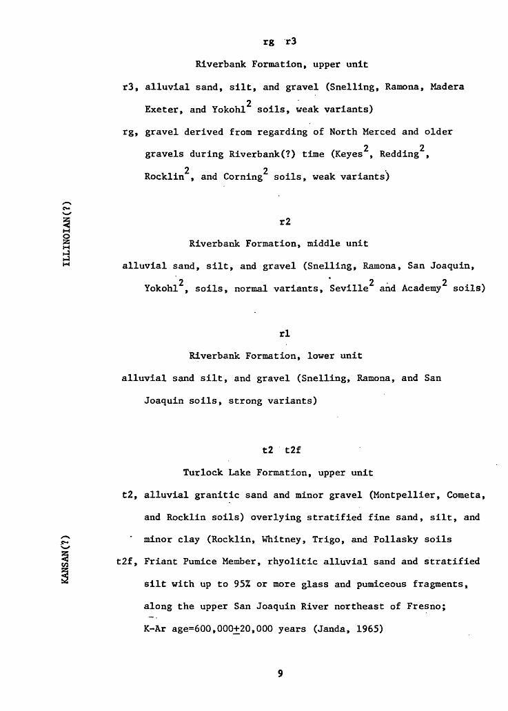
EXPLANATION TO ACCOMPANY OPEN-FILE MAPS 76-836 THROUGH 76-841 by Denis E. Marchand Purpose of Map and Basis for Recognition of Map Units This map is one of a series showing the distribution of unconsolidated and moderately consolidated Cenozoic deposits in the San Joaquin-Sacramento Valley and is a product of a regional study of the depositional and tectonic history of the Central Valley. Emphasis in mapping was placed upon Quater- . 4 nary deposits. Pre-Quaternary contacts were drawn primarily from soil survey maps, aerial photographs, and topography, augmented by local field checking, and are subject to revision. The Quaternary deposits occur as a series of nested alluvial terraces incised into Tertiary and Mesozoic rocks near the Sierra foothills and opening westward onto alluvial fans. Each fan commonly spills out west of and over the previous fan, such that the oldest fans head near the foot hills whereas the youngest fans occur close to the lower San Joaquin River. Geomorphic evidence of relative age is thus most useful near the mountains, but westward toward the basin the depositional surfaces converge such that soils and superposition of deposits separated by unconformities and buried paleosols become the primary distinguishing criteria. Relative age of Quaternary deposits was determined from superposition, degree of post-depositional soil development, position in a sequence of geomorphic surfaces, degree of erosional modification or dissection, and cross-cutting soil patterns.
Transcript
EXPLANATION TO ACCOMPANY OPEN-FILE MAPS 76-836 THROUGH 76-841
by
Denis E. Marchand
Purpose of Map and Basis for Recognition of Map Units
This map is one of a series showing the distribution of unconsolidated
and moderately consolidated Cenozoic deposits in the San Joaquin-Sacramento
Valley and is a product of a regional study of the depositional and tectonic
history of the Central Valley. Emphasis in mapping was placed upon Quater-. 4
nary deposits. Pre-Quaternary contacts were drawn primarily from soil
survey maps, aerial photographs, and topography, augmented by local field
checking, and are subject to revision. The Quaternary deposits occur as
a series of nested alluvial terraces incised into Tertiary and Mesozoic
rocks near the Sierra foothills and opening westward onto alluvial fans.
Each fan commonly spills out west of and over the previous fan, such that
the oldest fans head near the foot hills whereas the youngest fans occur
close to the lower San Joaquin River. Geomorphic evidence of relative
age is thus most useful near the mountains, but westward toward the basin
the depositional surfaces converge such that soils and superposition of
deposits separated by unconformities and buried paleosols become the
primary distinguishing criteria. Relative age of Quaternary deposits
was determined from superposition, degree of post-depositional soil
development, position in a sequence of geomorphic surfaces, degree of
erosional modification or dissection, and cross-cutting soil patterns.
Absolute ages are discussed by Marchand and Allwardt, in Iprooc, and
Marchand (1976). Facies representing contrasts in materials resulting
from deposition in differing geologic environments were recognized from
soil map units, aided by field reconnaissance.
Methods of Approach
Soil map units were reduced or enlarged to 1:24,000 scale and trans
ferred manually onto standard 7 1/2-minute topographic maps. Some soil
series were combined, others subdivided to best conform to geologic map
units as determined from field observations of soils and deposits in
auger holes, river bluffs, roadcuts, canal excavations, and other suit
able exposures. The resulting soils contacts were then modified by
means of 1:20,000 U.S. Geological Survey aerial photographs (flown
primarily in 1946; some in 1959, 1962, and 1963), field reconnaissance,
and topography, especially in those quadrangles having 5-foot contours.
Prominent lineaments believed to be structural in nature were delineated
from 1:20,000 aerial photographs and in some places extended using topo
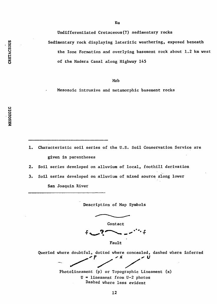
graphy. Those which involve verifiable displacement of deposits or
soils are shown as faults; the other lineaments probably represent
fractures having little or no displacement, although offsets of a few
feet in eroded Riverbank or pre-Riverbank deposits cannot be consistently
recognized without detailed study.
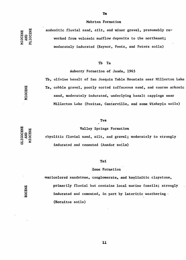
Summary of Cenozoic Geologic History
Presently available structural and stratigraphic evidence would
suggest a history of progressive, perhaps intermittent Sierran uplift
since Eocene time. Significant westward tilting of the central Sierra
Nevada occurred between Mehrten and China Hat time and may have been
responsible for the outpouring of the thick China Hat Gravel Member of
the Laguna Formation. The Laguna Formation records at least two major
episodes of granitic alluviation, separated by an extensive period of
soil formation, and may record the earliest glaciation of the Sierra
Nevada. The final major tilting and uplift of the Sierra Nevada seems
to have occurred between China Hat and North Merced time. The net\
result of these two periods of late Tertiary Sierran uplift was a
shifting of drainage direction from southwesterly to westerly, suggesting
that late Tertiary uplift in the southern Sierra Nevada may have con
siderably exceeded that in the north. During latest Pliocene or earliest
Pleistocene time, the North Merced pediment was beveled across Tertiary
and older rocks along the entire eastern margin of the Sierra Nevada.
Beginning in early Turlock Lake time, at least seven periods of glacial
outwash deposition, followed by extensive periods of stability and soil
formation and later by incision and dissection, appear to have been
superimposed on a progressively subsiding San Joaquin Valley. Minor
Sierran tilting may have continued through Quaternary time, providing
an explanation for the converging geomorphic surfaces and westward
shifts in fan position. Some of the observed lineaments and faults,
especially the northwesterly trending sets, could be tensional features
associated with a hinge line along the boundary between the Sierra
Nevada and the subsiding San Joaquin Valley.
Acknowledgments
Mapping and correlation of Quaternary deposits in the eastern San
Joaquin Valley has been greatly facilitated by consultation with many
geologists and soil scientists, especially R. J. Arkley, J. A. Bartow,
P. C. Bateman, Terry Grant, R. Harpster, E. J. Helley, G. L. Huntington,
R. J. Janda, William Page, A. M. Sarna-Wojcicki, and Clyde Wahrhaftig.
Michael Doukas identified and transferred photolineaments onto 7 1/2-
minute quadrangle maps. N. King Huber field checked some of the
Auberry Formation contacts east of Friant.
References
Arkley, R. J., 1954, Soils of eastern Merced County: Univ. of Calif.
Calif. Agri. Experiment Sta. Soil Survey no. 11, 174 p.
____, 1962a, The geology, geomorphology, and soils of the San Joaquin
Valley in the vicinity of the Merced River, California in Cal'if..
Div. Mines and Geol. Bull. 182, Geologic Guide to the Merced Canyon
and Yosemite Valley, p. 25-31.
____, 1962b, Soil survey of the Merced area, California: U.S. Dept.
Agri., Soil Survey Ser. 1950, no. 7, 131 p.
____, 1964, Soil survey of the eastern Stanislaus area, California:
U.S. Dept. Agri., Soil Survey Ser. 1957, no. 20, 160 p.
Croft, M. G., 1972, Subsurface geology of the late Tertiary and Quaternary
water-bearing deposits of the southern part of the San Joaquin
Valley, California: U.S. Geol. Survey Water-Supply Paper 1999-H, 29 p.
Davis, S. N., and Hall, F. R., 1959, Water quality of eastern Stanislaus
and northern Merced Counties, California: Stanford Univ. Pub. Geol.
Sci., v. 6, no. 1, 112 p.
Gale, H. S., Piper, A. M., and Thomas, H. E., 1939, Geology of the
Mokelumne area, California in Piper and others: U.S. Geol. Survey
Water-Supply Paper 780, p. 14-100.
Helley, E. J., 1967, Sediment transport in the Chowchilla River basin:
Mariposa, Madera, and Merced Counties, California: unpub. Ph. D.
dissertation, Dept. of Geol..and Geophysics, Univ. of Calif.,
Berkeley, 153 p.
Huntington, G. L., 1971, Soil survey of the eastern Fresno area, California;
U.S. Dept. Agri., 323 p.
Janda, R. J., 1965, Quaternary alluvium near Friant, California in
INQUA Guidebook for Field Conference I, Northern Great Basin and
California, p. 128-133.
____, 1966, Pleistocene history and hydrology of the upper San Joaquin
River, California: Berkeley, Univ. of Calif. Ph..D. Dissertation,
425 p. . .
Janda, R. J., and Croft, M. G., 1967, The stratigraphic significance
of a sequence of noncalcic brown soils formed on the Quaternary
alluvium of the northeastern San Joaquin Valley, California:
p. 158-190 in INQUA VII Congress, ProcV, v. 9, Quaternary Soils,
Reno, Nev., Center for Water Res. Rese.arch, Desert Research Inst.
Marchand, D. E., 1976, Late Cenozoic stratigraphy and history of the
northeastern San Joaquin Valley: some early results of a regional
study (abs): Geological Society of America, Cordilleran Section,
72nd Ann. Mtg., Abstracts with Programs, v. 8, no. 3, p. 393-394.
tAViAttb * ci $r iMarchand, D. E., and Allwardt, Alan, inipTreq<g, Late Cenozoic strati-
graphic units, northeastern San Joaquin Valley: U. S. Geol. Survey
Bulletin.
Marchand, D. E., and Harden, Jennifer, 1976, Soil chronosequences,
northeastern San Joaquin Valley, California (abs.): American
Quaternary Association Abstracts of the Fourth Biennial Mtg.,
Tempe, Ariz., p. 110.
Shlemon, R. J., 1967a, Landform-soil relationships in northern Sacramento
County, California: unpub. Ph. D. dissertation, Univ. of Calif.,
Davis. -
____, 1967b, Quaternary geology of northern Sacramento County,
California: Geol Soc. Sacramento Ann. Field Trip Guidebook, 60 p.
6
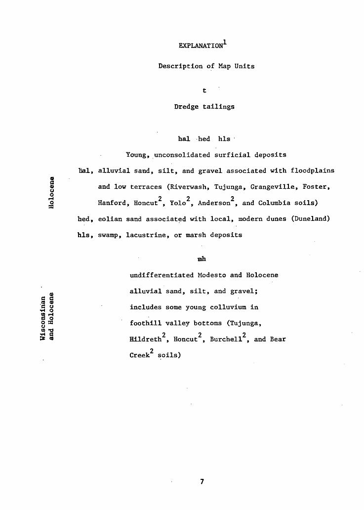
EXPLANATION1
Description of Map Units
t
Dredge tailings
hal bed his
Young, unconsolidated surficial deposits
Tial, alluvial sand, silt, and gravel associated with floodplains
§« and low terraces (Riverwash, Tujunga, Grangeville, Foster,
*H 222o Hanford, Honcut , Yolo , Anderson , and Columbia soils)33
hed, eolian sand associated with local, modern dunes (Duneland)
his, swamp, lacustrine, or marsh deposits
mh
undifferentiated Modesto and Holocene
alluvial sand, silt, and gravel;a a§ 0)
includes some young colluvium in
g 33 foothill valley bottoms (Tujunga,o> -or* «3 222I* « Hildreth , Honcut , Burchell , and Bear
2 Creek soils)
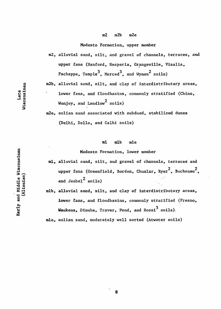
m2 m2b m2e
Modesto Formation, upper member
m2, alluvial sand, silt, and gravel of channels, terraces, and