+ All Categories
Home > Documents > Exploration workflows in GIS - High Performance … by managing and analysing the data and...

Exploration workflows in GIS - High Performance … by managing and analysing the data and...

Date post: 11-Jun-2018
Category:
Upload: tranhanh
View: 217 times
Download: 0 times
Share this document with a friend
2
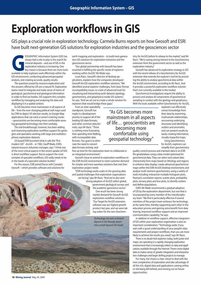
18 Mining Journal May 29, 2009 Geographic Information System – GIS G EOGRAPHIC Information System (GIS) has always had a role to play in the search for mineral deposits – and use of GIS in the exploration industry is increasing. One key reason is because there are more tools available to help explorers work effectively within the GIS environment, conducting advanced geospatial analysis, and creating accurate, quality results. The questions posed by resource exploration and the answers offered by GIS are a natural fit. Exploration teams need to integrate and make sense of reams of geological, geochemical and geological information in order to find ore bodies. GIS supports this complex workflow by managing and analysing the data and displaying it in a spatial context. As GIS becomes more mainstream in all aspects of life – from the ever-changing political wall maps used by CNN to depict US election results, to Google Map applications that can track a runner’s training routes – geoscientists are becoming more comfortable weav- ing geospatial technology into their workday. The real breakthrough, however, has been adding and improving exploration workflow support for geolo- gists and specialists working with large and multidisci- plinary exploration datasets. US-based ESRI launched what it calls the “first modern GIS” –ArcGIS – in 1982. Geoff Wade, ESRI’s natural resource industries manager, says: “I think one of the most critical aspects in the recent uptake (of GIS) is direct workflow support. But to support the most complex of specialist workflows, GIS really needs to be in the hands of a specialist solution builder.” For this reason, ESRI joined forces with Canada’s Geosoft – which provides software and solutions for earth mapping and exploration – to build next-genera- tion GIS solutions for exploration industries and the geosciences sector. “Our global partnership with Geosoft has been essential in fulfilling the specific needs of explorers working within ArcGIS,” Mr Wade says. Louis Racic, Geosoft’s director of desktop ap- plications, explains how the companies developed Geosoft/ArcGIS exploration workflow solutions. “We identified several explorer challenges, from basic format incompatibility issues, to a lack of advanced tools for visualising and interpreting earth datasets (geology, geochemistry, and geophysics) inside GIS systems,” he says. “And we set out to create a whole solution for explorers that would bridge these gaps.” From an inter-operability standpoint, Geosoft has made it a development priority to support all of the leading GIS data formats, and other common data for- mats, says Mr Racic. “There is nothing more frustrating than spending time fiddling with incompatible data formats. Our goal is to elimi- nate the need to convert data formats entirely, and free up time for the exploration team to collaborate in an integrated environment.” Geosoft chose to extend its exploration workflows to the ESRI ArcGIS environment to meet customer demand for simpler and more seamless solutions that met their exploration project needs. “ESRI technology easily scales to the growing data and spatial challenges that exploration organisations are facing,” says Mr Racic. “And we’ve also seen strong adoption of ArcGIS within global, government geological surveys and the academic geoscience sector.” One result has been strong market demand for Geosoft ArcGIS exploration workflow solutions. “Our Target for ArcGIS extension software was our highest growth product last year, and we were tak- ing orders for the new Geochem- istry for ArcGIS before its release to the market,” said Mr Racic. “We’re seeing strong interest in the Geochemistry extension from the government sector as well as the exploration industry.” Geosoft has advanced its exploration strategy in GIS with the recent release of a Geochemistry for ArcGIS extension that extends the explorer’s tool kit by provid- ing the ability to analyse geochemical data within the ArcGIS environment, according to Mr Racic. And it provides a powerful exploration workflow solution that’s not currently available in the market. Geochemical investigations require the ability to process and analyse all components of geochemical sampling in context with the geology and geophysics. With the tools available within Geochemistry for ArcGIS, explorers can effectively extract knowledge from their data by examining multivariate relationships, uncovering underlying structures and identifying outliers and anomalies, and can present results by easily creating informative, visually impactful maps. Using Geochemistry for ArcGIS, explorers can simplify their geochemistry quality control process and maintain data in an ESRI file geodatabase using a data model optimised for geochemical data. They can select and subset data interactively from maps based on lithology and regions to enhance data display; create advanced geochemical maps within the ESRI ArcGIS Desktop environment; and analyse multi-element geochemistry using a variety of tools including: interactive multiple histogram plots, Pearson’s correlation reports, scatter plots, probability plots, ternary plots and box plots, to identify outliers and define populations. ESRI’s Mr Wade recommends a gradual adoption of GIS by the exploration department, but one that is incorporated by every member of the interdisciplin- ary team. “We find it particularly effective if several members of the project team embrace the technology at the same time, thereby supporting each other in the education process and gaining extra benefit from data sharing, improved workflow support and an improved communication capability,” he says. In addition to workflow support, effective integration of GIS within your exploration organisation is also an important consideration. “Technology aside, if you start with a good understanding of your people’s data requirements and project workflows, than you are more likely to achieve the results you need,” says Mr Racic. There is no doubt that explorers today, both junior and major, are operating in a rapidly changing exploration environment that is increasingly reliant on data and appli- cations available through the Internet. There’s more digital data to makes sense of, greater integration and interpreta- tion challenges and larger drilling projects to manage. For many, the choice is clear: retool to deal with the new complexities of exploration and take advantage of all the rich, digital data and applications coming online, or risk being left behind, and missing out on future opportunities. Exploration workflows in GIS GIS plays a crucial role in exploration technology. Carmela Burns reports on how Geosoft and ESRI have built next-generation GIS solutions for exploration industries and the geosciences sector Technology can turn a mineral deposit in the Nevada desert into a multi-layered 3D model “As GIS becomes more mainstream in all aspects of life… geoscientists are becoming more comfortable using geospatial technology”
Transcript

18 Mining Journal May 29, 2009

Geographic Information System – GIS

GEOGRAPHIC Information System (GIS) has always had a role to play in the search for mineral deposits – and use of GIS in the exploration industry is increasing. One key reason is because there are more tools

available to help explorers work effectively within the GIS environment, conducting advanced geospatial analysis, and creating accurate, quality results.

The questions posed by resource exploration and the answers offered by GIS are a natural fit. Exploration teams need to integrate and make sense of reams of geological, geochemical and geological information in order to find ore bodies. GIS supports this complex workflow by managing and analysing the data and displaying it in a spatial context.

As GIS becomes more mainstream in all aspects of life – from the ever-changing political wall maps used by Cnn to depict US election results, to Google Map applications that can track a runner’s training routes – geoscientists are becoming more comfortable weav-ing geospatial technology into their workday.

The real breakthrough, however, has been adding and improving exploration workflow support for geolo-gists and specialists working with large and multidisci-plinary exploration datasets.

US-based ESRI launched what it calls the “first modern GIS” –ArcGIS – in 1982. Geoff wade, ESRI’s natural resource industries manager, says: “I think one of the most critical aspects in the recent uptake (of GIS) is direct workflow support. But to support the most complex of specialist workflows, GIS really needs to be in the hands of a specialist solution builder.”

For this reason, ESRI joined forces with Canada’s Geosoft – which provides software and solutions for

earth mapping and exploration – to build next-genera-tion GIS solutions for exploration industries and the geosciences sector.

“Our global partnership with Geosoft has been essential in fulfilling the specific needs of explorers working within ArcGIS,” Mr wade says.

Louis Racic, Geosoft’s director of desktop ap-plications, explains how the companies developed Geosoft/ArcGIS exploration workflow solutions. “we identified several explorer challenges, from basic format incompatibility issues, to a lack of advanced tools for visualising and interpreting earth datasets (geology, geochemistry, and geophysics) inside GIS systems,” he says. “And we set out to create a whole solution for explorers that would bridge these gaps.”

From an inter-operability standpoint, Geosoft has made it a development priority to support all of the leading GIS data formats, and other common data for-mats, says Mr Racic. “There is nothing more frustrating than spending time fiddling with incompatible data formats. Our goal is to elimi-nate the need to convert data formats entirely, and free up time for the exploration team to collaborate in an integrated environment.”

Geosoft chose to extend its exploration workflows to the ESRI ArcGIS environment to meet customer demand for simpler and more seamless solutions that met their exploration project needs.

“ESRI technology easily scales to the growing data and spatial challenges that exploration organisations

are facing,” says Mr Racic. “And we’ve also seen strong adoption of ArcGIS within global,

government geological surveys and the academic geoscience sector.”

One result has been strong market demand for Geosoft ArcGIS exploration workflow solutions. “Our Target for ArcGIS extension software was our highest growth product last year, and we were tak-ing orders for the new Geochem-

istry for ArcGIS before its release to the market,” said Mr Racic. “we’re seeing strong interest in the Geochemistry extension from the government sector as well as the exploration industry.”

Geosoft has advanced its exploration strategy in GIS with the recent release of a Geochemistry for ArcGIS extension that extends the explorer’s tool kit by provid-ing the ability to analyse geochemical data within the ArcGIS environment, according to Mr Racic. And it provides a powerful exploration workflow solution that’s not currently available in the market.

Geochemical investigations require the ability to process and analyse all components of geochemical sampling in context with the geology and geophysics. with the tools available within Geochemistry for ArcGIS,

explorers can effectively extract knowledge from their data by examining multivariate relationships, uncovering underlying structures and identifying outliers and anomalies, and can present results by easily creating informative, visually impactful maps.

Using Geochemistry for ArcGIS, explorers can simplify their geochemistry

quality control process and maintain data in an ESRI file geodatabase using a data model optimised for geochemical data. They can select and subset data interactively from maps based on lithology and regions to enhance data display; create advanced geochemical maps within the ESRI ArcGIS Desktop environment; and analyse multi-element geochemistry using a variety of tools including: interactive multiple histogram plots, Pearson’s correlation reports, scatter plots, probability plots, ternary plots and box plots, to identify outliers and define populations.

ESRI’s Mr wade recommends a gradual adoption of GIS by the exploration department, but one that is incorporated by every member of the interdisciplin-ary team. “we find it particularly effective if several members of the project team embrace the technology at the same time, thereby supporting each other in the education process and gaining extra benefit from data sharing, improved workflow support and an improved communication capability,” he says.

In addition to workflow support, effective integration of GIS within your exploration organisation is also an important consideration. “Technology aside, if you start with a good understanding of your people’s data requirements and project workflows, than you are more likely to achieve the results you need,” says Mr Racic.

There is no doubt that explorers today, both junior and major, are operating in a rapidly changing exploration environment that is increasingly reliant on data and appli-cations available through the Internet. There’s more digital data to makes sense of, greater integration and interpreta-tion challenges and larger drilling projects to manage.

For many, the choice is clear: retool to deal with the new complexities of exploration and take advantage of all the rich, digital data and applications coming online, or risk being left behind, and missing out on future opportunities.

Exploration workflows in GISGIS plays a crucial role in exploration technology. Carmela Burns reports on how Geosoft and ESRI have built next-generation GIS solutions for exploration industries and the geosciences sector

Technology can turn a mineral deposit in the Nevada desert into a multi-layered 3D model

“As GIS becomes more mainstream in all aspects of life… geoscientists are

becoming more comfortable using

geospatial technology”

May 29, 2009 Mining Journal 19www.mining-journal.comwww.mining-journal.com

Geographic Information System – GIS

AS A well-established consulting geologist working in the middle of the nevada goldfields, Buster Hunsaker has adopted software and GIS as a critical part of his exploration tool kit – both in the field and in the office.

Being faster and more efficient in using technol-ogy for geological insight and project management has given him an edge in what can be a competitive business, especially during cyclical downturns in the mining industry such as the one we are experiencing today. More importantly, it’s enabled him to produce better results for his customers.

“Our expertise in GIS has opened a lot of doors for us,” says Mr Hunsaker, whose company Hunsaker Inc specialises in early-stage gold exploration projects. “As a consultant, bringing both our experience and tech-nology to bear on projects is a tremendous advantage. we see a real gap in the application of technology to exploration. There are not as many senior people applying it as there should be.”

The Carlin gold belt in north-central nevada is one of the richest in the world. Mr Hunsaker estimates that about 8% of global gold production comes from deposits within a 100km of his headquarters in Elko. Because the state has been so intensively mined and explored over the years, there is a rich store of available data, including a comprehensive sub-surface database.

That’s where the application of digital technology comes in handy. without the tools to process and make sense of it, all that data would be mindboggling at best and virtually useless at worst.

Using ESRI’s ArcView to visualise geographic data in combination with Geosoft’s Target for ArcGIS to mange drill projects, Mr Hunsaker is able to integrate volumes of old and new data, both public and private, to highlight areas with mineral potential, work within different scales, and generate 3D renderings of the information.

“There are a lot of new geological concepts coming out in nevada,” he says. “we can take the new geologic maps and apply existing data to them and it gives us new ways to interpret the existing data.”

Though Mr Hunsaker has been using GIS for years, many mining companies are just beginning to see the value of integrating geological, geochemical and geophysical data from government geologi-cal surveys – which are increasingly publishing data in ESRI formats – with their own explora-tion data as part of their workflow.

The most obvious ad-vantages are efficiencies in project and data man-agement, time savings, increased productivity and better decision making.

The introduction of extensions for GIS, such as Ge-osoft’s Target for ArcGIS, has made the suite of spatial analysis tools even more powerful by providing the ability to visualise sub-surface geological data within a GIS environment.

“we wouldn’t consider doing something without

the third dimension if we have drill data available,” says Mr Hunsaker, “and Target provides the ability to handle that third dimension quickly and easily. That’s both the geophysics as well as the drillhole data.

“Having the 3D perspective also means we’re quite comfortable bringing in a lot of data because we’re confident we can handle it and it won’t overwhelm us.”

Mr Hunsaker’s adoption of GIS for mineral explora-tion began 12 years ago when he was looking for an efficient way to track federal mining claims. A colleague directed him to ArcView and there has been no looking back.

“ArcView’s ability to handle large amounts of data led us to expand from land title data to all kinds of geologic data,” he says.

As Mr Hunsaker’s experience with GIS grew, he was able to take the mostly raster data available in nevada and convert them into GIS format. (Raster data store

values in a grid, and are used for items such as aerial photographs and scanned maps.) That gives him another edge over the competition. “From a business viewpoint, it has become a good income stream for us,” he says.

Another unique aspect of Mr Hunsaker’s approach to exploration is his use of ESRI’s ArcPad, a software

program that allows data capture in the field on ultra-rugged field computers or handheld devices. The software is commonly used in urban areas where there is easy access to mobile phone networks, but is just beginning to enter the mineral exploration industry.

Using ArcPad has allowed Mr Hunsaker to generate data in GIS format while he is in the field, resulting in

an instant compatibility between field and office that would not be possible were he still using a notebook to scribble observations about outcrops and other geological information.

In the historic gold mining district of wonder, nevada, for instance, Mr Hunsaker used ESRI’s ArcMap to convert 34 years of data generated by his client and a century of archival data into a standard GIS coordinate system. He then took the sub-surface data – including results from more than 100 boreholes – and applied Geosoft’s Target for ArcGIS to generate cross-sections.

He is adding even more value to the historic data by using ArcPad to complete additional surface mapping in the field, creating another layer of digital informa-tion that can be used to explore the district.

“The ArcMap model and the Geosoft extension allowed me to generate sections that have the latest mapping from ArcPad windowed in the plan portion, straight out of the field,” he says.

As important as it is today, adapting technology to exploration will be even more essential in the future.

“we are generating massive amounts of data, all of it digital and most in GIS format. you need technology to effectively explore all this new data and fit it in to your projects,” says Mr Hunsaker. “The new technology that’s coming on stream, like Geosoft DAP and Dapple, is phenomenal. you can take an AirCard even in an area where you have limited coverage, and you can take a cell connection with your tablet computer and access these data sets.

“Don’t even think about the old tools. Think about the new tools that are coming on board. you need to become really efficient with data.”

Carmela Burns is editor of Earth Explorer (www.earthex-plorer.com), Geosoft’s magazine and online news site covering the earth sciences and exploration

“we see a real gap in the application of technology to exploration. There are not as many senior people applying

it as there should be” Buster Hunsaker, Hunsaker Inc

GIS CASE STudY: ExPLORING THE dATA-RICH NEVAdA GOLdfIELdS

Buster Hunsaker tells Carmela Burns how being faster and more efficient in how he uses technology for geological insight and project management has given him an edge in the nevada goldfields

Buster Hunsaker converted 34 years of data into a GIS model using Geosoft


Recommended