REV # REV DATE DESCRIPTION PREP BY DISCIPLINE CHECKED ENDORSED APPROVED 2 11-May-2017 Issued for use See page 2 for signatures IDP JM LAD DV 1 28-Oct-2016 Issued for use IDP JM LAD DV 0 28-Mar-2013 Issued for use SW MB KW, BP, MS DA, DP Unclassified ExxonMobil PNG Limited ExxonMobil PNG Limited Production Operations Biodiversity Implementation and Monitoring Program PGGP-EH-SSZZZ-000008
Transcript
REV # REV DATE DESCRIPTION PREP BY DISCIPLINE CHECKED ENDORSED APPROVED
2 11-May-2017 Issued for use See page 2 for signatures
IDP JM LAD DV
1 28-Oct-2016 Issued for use IDP JM LAD DV
0 28-Mar-2013 Issued for use SW MB KW, BP, MS DA, DP
Unclassified
ExxonMobil PNG Limited
ExxonMobil PNG Limited Production Operations
Biodiversity Implementation and Monitoring Program
PGGP-EH-SSZZZ-000008
Unclassified EXXONMOBIL PNG LIMITED Biodiversity Implementation and Monitoring Program Production Operations Page 2 of 43
PGGP-EH-SRZZZ-000008 May 2017 Rev 2
ExxonMobil PNG Limited Production Operations
Biodiversity Implementation and Monitoring Program
PGGP-EH-SSZZZ-000008
ExxonMobil PNG Limited
Via email (11-May-2017)
Via email (11-May-2017)
Laura Ann Dresser Dennis Vidmar E&R Supervisor SHE Manager Endorsed Approved
Unclassified EXXONMOBIL PNG LIMITED Biodiversity Implementation and Monitoring Program Production Operations Page 3 of 43
4.0 OFFSET PROGRAM IMPLEMENTATION AND MONITORING ............................... 294.1 Offset program implementation ............................................................................. 294.2 Programmed Monitoring Activity 4: Efficacy of Biodiversity Offsets ...................... 37
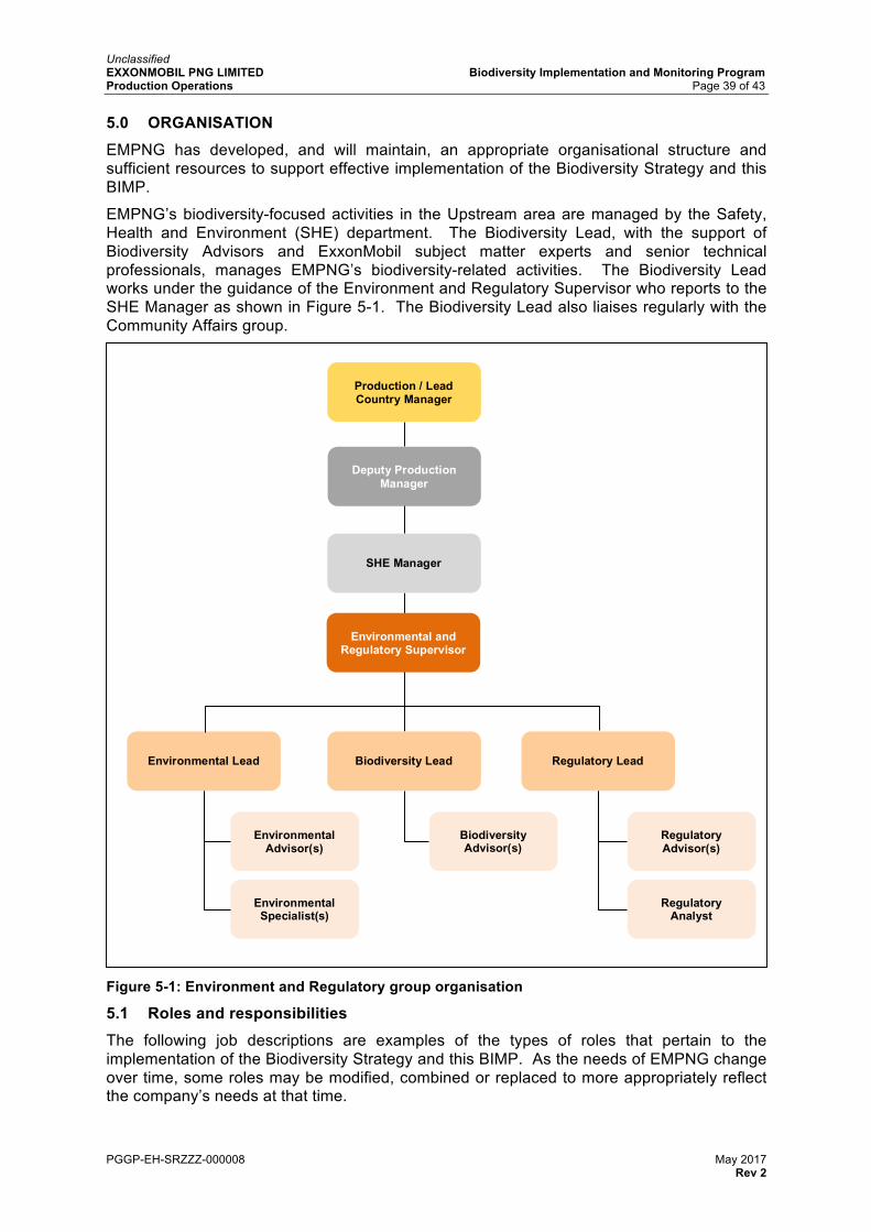
5.0 ORGANISATION ....................................................................................................... 395.1 Roles and responsibilities ..................................................................................... 395.2 Training and awareness ........................................................................................ 40
Table 1-1: Monitoring programs .............................................................................................. 7Table 1-2: Biodiversity Strategy objectives and their associated monitoring programs .......... 7Table 2-1: Levels of significance used to classify observed changes ................................... 11Table 3-1: Focal habitats and significant ecological features monitoring criteria .................. 18Table 3-2: Monitoring system for Objectives 1, 2 and 3 of the Biodiversity Strategy ............ 22Table 4-1: Component 1 work activities ................................................................................ 31Table 4-2: Component 2 work activities ................................................................................ 31Table 4-3: Component 3 work activities ................................................................................ 32Table 4-4: Component 4 work activities ................................................................................ 33Table 4-5: Component 5 work activities ................................................................................ 36
FIGURES
Figure 2-1: Implementation approach ..................................................................................... 9Figure 2-2: Management of residual impacts and offsets ..................................................... 13Figure 3-1: PMA1 imagery capture areas ............................................................................. 16Figure 3-2: PMA3 monitoring transects ................................................................................. 21Figure 4-1: Offset program framework .................................................................................. 30Figure 4-2: Component 4 Wildlife Management Areas ......................................................... 33Figure 4-3: Consultation locations representing the lower elevation zone element .............. 35Figure 5-1: Environment and Regulatory group organisation ................................................ 39
Unclassified EXXONMOBIL PNG LIMITED Biodiversity Implementation and Monitoring Program Production Operations Page 4 of 43
PGGP-EH-SRZZZ-000008 May 2017 Rev 2
ACRONYMS
ACRONYM DESCRIPTION
BAA Biodiversity Assessment Area
BIMP Biodiversity Implementation and Monitoring Program
CEPA Conservation and Environment Protection Authority
EMP Environmental Management Plan
EMPNG ExxonMobil PNG Limited
GIS Geographical Information System
IUCN International Union for Conservation of Nature
KPI Key Performance Indicator
LNG Liquefied Natural Gas
NBSAP National Biodiversity Strategy and Action Plan
NGO Non-government organisation
PMA Programmed Monitoring Activities
PNG Papua New Guinea
RAP Rapid Assessment
ROW Right of Way
SHE Safety, Security, Health and Environment
WMA Wildlife Management Area
Corporate Separateness Notice Nothing in this material is intended to override the corporate separateness of local entities. Working relationships discussed in this material do not necessarily represent a reporting connection, but may reflect a functional guidance, stewardship, or service relationship. Where shareholder consideration of a local entity matter is contemplated by this material, responsibility for action remains with the local entity. The terms corporation, company, affiliate, ExxonMobil, Exxon, Mobil, Esso, our, we and its, as used in this material may refer to Exxon Mobil Corporation, to one of its divisions, or to the companies affiliated with Exxon Mobil Corporation, or to any one or more of the foregoing. The shorter terms are used merely for convenience and simplicity. PNG LNG is an integrated development that includes gas production and processing facilities, onshore and offshore pipelines and liquefaction facilities. Participating interests are affiliates of Exxon Mobil Corporation (including ExxonMobil PNG Limited as operator), Oil Search Limited, Kumul Petroleum Holdings Limited, Santos Limited, JX Nippon Oil and Gas Exploration and Mineral Resources Development Company.
Unclassified EXXONMOBIL PNG LIMITED Biodiversity Implementation and Monitoring Program Production Operations Page 5 of 43
PGGP-EH-SRZZZ-000008 May 2017 Rev 2
PREFACE
ExxonMobil PNG Limited (EMPNG) is committed to safeguarding biodiversity in areas where the company operates and, in particular, the biodiversity values in the Upstream area of the Papua New Guinea Liquefied Natural Gas (PNG LNG) Project. The Biodiversity Strategy and this Biodiversity Implementation and Monitoring Program outline how impacts on biodiversity will be assessed and managed.
EMPNG manages potential impacts to biodiversity across the Upstream area and the LNG Plant and Marine Facilities area through implementation of its Environmental and Social Management Plan (ESMP). While the ESMP applies to a broad range of land and aquatic environments in which PNG LNG is operating, the largely undisturbed tropical forest in the Upstream area was identified as having the highest biodiversity value. This area is also where most of the biodiversity-related impacts from the construction phase were predicted to occur in the PNG LNG Project Environmental Impact Statement. As such, the Upstream area requires additional biodiversity-related management processes to supplement the measures outlined in the ESMP. The Biodiversity Strategy and this Biodiversity Implementation and Monitoring Program address these needs.
The Biodiversity Strategy is an over-arching document that describes the framework and general approach, and is supported by the Biodiversity Implementation and Monitoring Program and a set of Protocols, as outlined below.
Biodiversity strategy document framework
Unclassified EXXONMOBIL PNG LIMITED Biodiversity Implementation and Monitoring Program Production Operations Page 6 of 43
PGGP-EH-SRZZZ-000008 May 2017 Rev 2
1.0 INTRODUCTION
This Biodiversity Implementation and Monitoring Program (BIMP) describes the implementation, monitoring and evaluation process EMPNG is following to achieve the objectives of the Biodiversity Strategy, which are:
1. At the large scale, maintain the intactness of the Upstream area as a whole – The long-term maintenance of biodiversity in the Upstream area, within a natural range of variation, requires the long-term functioning of the constituent ecosystems. This Objective will be realised by ensuring control of PNG LNG-related impacts capable of system wide effects, such as the introduction or spread of invasive species and enhanced access.
2. At the medium scale, conserve priority ecosystems – Some PNG LNG infrastructure is located within priority ecosystems, and therefore it is necessary to demonstrate that these ecosystems do not degrade as a result of construction and/or production activities. Realisation of this Objective has, in some cases, required changes to PNG LNG’s design and the development of specific risk management measures that require ongoing management and control during production.
3. At the small scale, protect focal habitats – Focal habitats and significant ecological features have been avoided or otherwise managed during construction, and in production, so that the risks of reducing a population of Critically Endangered or Endangered species are as low as practicable.
4. Identify, measure and offset significant residual impacts – Impacts to those biodiversity values that were assessed as being significant and that cannot be avoided or otherwise managed (residual impacts) are remedied through an offset approach, to ensure no net loss of biodiversity.
This BIMP applies to the Upstream area, which contains a high concentration of high value biodiversity attributes and is where potentially significant residual biodiversity impacts could occur. The processes outlined in this BIMP aim to measure residual construction-related impacts that could manifest, evolve or persist over time, as well as conservation gains through the implementation of offsets.
EMPNG has established the following five Key Performance Indicators (KPIs) that reflect the objectives of the Biodiversity Strategy:
• 1 – Intactness of forest: the physical continuity of forest canopy cover, expressed as percentage cover, as compared with a defined baseline.
• 2 – Trends in species diversity and abundance: the diversity of species in a defined area, expressed as both the number of species and the composition of species assemblages, and the number of individuals of the target species, as compared with a defined baseline.
• 3 – Condition of focal habitats: the ecological functionality of focal habitats and significant ecological features, expressed in terms of evidence of physical disturbance, both natural and human-induced, as compared with a defined baseline.
• 4 – Occurrence of invasive species/pathogens: presence of invasive species/pathogens in a defined area, as compared with a defined baseline.
• 5 – Offset gains: measureable conservation outcomes resulting from averted deforestation/deterioration of forest condition, and restoration of degraded areas.
Four Programmed Monitoring Activities (PMAs) are used to collect information for analysis against the KPIs. Each PMA is supported by a Protocol that sets out the evaluation process and contribution towards the KPIs in more detail. Three Environmental Management Plan
Unclassified EXXONMOBIL PNG LIMITED Biodiversity Implementation and Monitoring Program Production Operations Page 7 of 43
PGGP-EH-SRZZZ-000008 May 2017 Rev 2
(EMP) protocols are also used to collect information for analysis against the KPIs1. The PMAs and the EMP protocols, collectively referred to as the ‘monitoring programs’ are summarised in Table 1-1.
Table 1-1: Monitoring programs
TITLE DESCRIPTION
PMA1 Remote Sensing of Broadscale Land Cover
PMA1 involves the use of remote sensing to determine the extent to which broadscale direct and indirect residual impacts eventuate as a result of PNG LNG
PMA2 Condition Surveys of Focal Habitats and Significant Ecological Features
PMA2 involves field surveys to collect data, adjacent to and in the vicinity of the pipeline Right of Way (ROW) and other PNG LNG facilities and infrastructure, relating to condition of focal habitats and significant ecological features
PMA3 Biodiversity Surveys PMA3 involves biodiversity field surveys providing flora and fauna data in and around the areas affected as part of PNG LNG and protected areas enhanced and/or established as part of the offset program
PMA4 Efficacy of Biodiversity Offsets
PMA4 monitors progress of the five components of the offset program to enable EMPNG to evaluate whether Objective 4 of the Biodiversity Strategy is being achieved
EMP Access Control
Access Control The Access Control Protocol formalises the monitoring of vehicle access to and movements along PNG LNG Project roads and infrastructure as part of a program to prevent potentially damaging third party activities resulting from access
EMP Invasive Species
Invasive Species and Plant Pathogens
The Invasive Species and Plant Pathogens Protocol formalises monitoring of the occurrence and distribution of invasive species, pests and plant pathogens, and provides guidance on remedial action, where required
EMP Regeneration Monitoring
Regeneration Monitoring
The Regeneration Monitoring Protocol formalises the collection and analysis of information relating to the regeneration of temporary work areas disturbed during construction of PNG LNG, and evaluated against established benchmarks
The monitoring programs are independent but complementary data collection programs, each of which is designed to gather information for several KPIs. Table 1-2 shows the relationship between the Biodiversity Strategy objectives, KPIs, and the associated monitoring programs.
Table 1-2: Biodiversity Strategy objectives and their associated monitoring programs
Objective 1 – Maintain the intactness of the Upstream area as a whole
1 – Intactness of forest PMA1 and EMP Access Control, EMP Regeneration Monitoring
2 – Trends in species diversity and abundance
PMA3
Objective 2 – Conserve priority ecosystems
1 – Intactness of forest PMA1 and EMP Access Control
2 – Trends in species diversity and abundance
PMA3
3 – Condition of focal habitats PMA2
1 Invasive species and plant pathogens, access control and regeneration monitoring link directly to the environmental management plans that form part of the Environmental and Social Management Plan for PNG LNG. For more details, refer to the production Environmental Management Plan: Upstream Facilities, Infrastructure, and Pipelines.
Unclassified EXXONMOBIL PNG LIMITED Biodiversity Implementation and Monitoring Program Production Operations Page 8 of 43
Objective 4 – Identify, measure and offset significant residual impacts
5 – Offset gains PMA1, PMA3 and PMA4
Through these measures, EMPNG is able to track progress toward achieving the Biodiversity Strategy goals, and subsequently demonstrate no net loss of biodiversity in the Upstream area.
Unclassified EXXONMOBIL PNG LIMITED Biodiversity Implementation and Monitoring Program Production Operations Page 9 of 43
PGGP-EH-SRZZZ-000008 May 2017 Rev 2
2.0 IMPLEMENTATION APPROACH
EMPNG has developed an approach to the implementation of the Biodiversity Strategy as shown in Figure 2-1. EMPNG’s response to monitoring results, as determined through progressive mapping of interim results against KPIs, is a key component of this approach.
Figure 2-1: Implementation approach
The approach to implementation of the Biodiversity Strategy is as follows:
1. Plan – Establish the Biodiversity Strategy with a set of objectives and defined biodiversity values. It also involves development of this BIMP.
2. Do – Undertake the PMAs as outlined in this BIMP and implement the components of the offset program. Monitoring results are measured against pre-determined KPIs.
3. Evaluate – Map monitoring results against KPIs and progress towards demonstrating no net loss.
4. The outcomes of evaluation will result in one of three actions:
a. Continue – If KPIs remain on target/schedule, and therefore the targeted outcome is achievable, then reassess the frequency of monitoring and continue monitoring over time.
b. Adjust – If KPIs are not on target/schedule, and the targeted outcome is delayed or not achievable, assess the level of significance and determine and implement an agreed management response.
c. Cease – If KPIs and the overall objectives of the Biodiversity Strategy are consistently met over time, implementation activities cease but a short-term care and maintenance program may be implemented to monitor for reversal in the achieved outcome.
Unclassified EXXONMOBIL PNG LIMITED Biodiversity Implementation and Monitoring Program Production Operations Page 10 of 43
PGGP-EH-SRZZZ-000008 May 2017 Rev 2
2.1 Adaptive management
EMPNG has designed this BIMP to be flexible so that the monitoring programs are providing sufficiently accurate and appropriate data. These monitoring programs may be modified in response to monitoring results, site conditions and lessons learned, on condition that an appropriate evidence-based justification can be made, and that modifications continue to enable the Biodiversity Strategy objectives to be achieved. With regard to PMA4, given its reliance on external input, the scope of monitoring needs to be able to respond to external prevailing circumstances, or changes in conservation objectives and the actions required to achieve those objectives.
The establishment of appropriate KPIs and underlying indicators (as shown in Table 3-2) is crucial to the evaluation process. The five KPIs were selected to reflect the values and objectives defined in the Biodiversity Strategy. They can be modified in response to monitoring results, changing circumstances and lessons learned (for example practicality, interpretability, usefulness). The criteria for choosing KPIs were:
• Relevance – KPIs must provide information directly relevant to the objectives of the Biodiversity Strategy and the biodiversity values of the Upstream area. They should enable clear distinction between activities and effects relating directly to PNG LNG versus effects attributable to third party activities and natural (non-anthropogenic) processes.
• Clarity – KPIs must be clear and unambiguous. • Reliability – KPIs must be based on precise and accurate data that is free from bias,
is accessible, can be repeatedly obtained and consistently interpreted. • Measurability – KPIs must enable confirmation of the extent to which results and
objectives have been achieved.
Adaptation will be made primarily through implementing a management response, which is defined as a specific action that is required to ensure the Biodiversity Strategy objectives can be met.
2.1.1 Evaluation of monitoring results
Two key components of EMPNG’s monitoring process involve evaluating results and formulating appropriate responses.
In relation to PMAs 1-3 and the EMP protocols, triggers for an EMPNG management response include, but are not limited to:
• a trend indicating an improvement in the diversity of flora and/or fauna, including recurring evidence that KPIs are being met
• evidence that a Biodiversity Strategy objective has been achieved and the endpoint has been reached
• a trend indicating a decline in the diversity of flora and/or fauna, or a change in composition of fauna and flora communities, that is outside the expected range of natural variability
• a trend indicating a decline in the populations of critically endangered or endangered species, or of other focal species that are appropriate indicators of ecosystem health
• introduction and establishment of invasive species expected to have significant deleterious effects on the biological values
• evidence of broadscale forest loss or degradation.
In the case of improving trends, EMPNG will work with specialist consultants and consider scaling down the frequency and scope of monitoring.
Where monitoring data indicate a Biodiversity Strategy objective has been achieved or the endpoint has been reached, the monitoring associated with that objective may be assessed as being redundant and may be discontinued. In these cases, a care and maintenance
Unclassified EXXONMOBIL PNG LIMITED Biodiversity Implementation and Monitoring Program Production Operations Page 11 of 43
PGGP-EH-SRZZZ-000008 May 2017 Rev 2
program may be required to ensure that there is no reversal in the achieved outcome. Additionally, if data can no longer be gathered in respect to an objective, the monitoring associated with that objective may be discontinued.
In the case of adverse trends, EMPNG will work with specialist consultants to interpret and validate monitoring data to assess the significance of observed change(s) and identify potential causes. The level of significance of the observed change(s) will then be assessed using a risk-based approach (as outlined in Section 2.1.2) so that the level of response and resources applied to remedy the situation are proportional to the biodiversity risk identified and EMPNG’s contribution to the triggering situation.
In relation to PMA4, EMPNG will evaluate monitoring results on a regular basis to confirm its offset targets are being met. In the event that progress is adversely affected by external factors, EMPNG will, in consultation with relevant stakeholders, develop and implement corrective actions such that the overall offset target can be achieved over the life of the project.
2.1.2 Assessing the level of significance
In relation to PMAs 1-3 and/or the EMP protocols, EMPNG anticipates that the condition of biodiversity values will naturally change over time. It is therefore important to have a guide for assessing both the degree of observed change, and its significance.
2.1.3 On-going risk assessment
On-going reviews will be undertaken to identify relevant threats and determine the measures that will shape the response. In many cases, the management of identified risks will be readily achievable and within EMPNG’s control. In these situations, EMPNG’s responses may involve either conducting a review to understand potential causes, taking action to manage the biodiversity values, or taking action to influence a positive outcome.
In some situations however, such as indirect residual impacts caused by third parties or more pervasive threats arising from broad-based social and other changes occurring in the region, the management of identified risks may be beyond EMPNG’s control. In these cases, EMPNG may engage with the relevant parties (for example landowning communities or the Papua New Guinean Government) to manage the risk with a goal to influence positive environmental and social outcomes.
Table 2-1 outlines three levels of significance used to classify observed changes (high, medium and low). This approach relies on an understanding of the extent of the impact and the anticipated recovery time. Impacts that affect a small proportion of the extent or abundance of the species that constitutes the biodiversity value, and are short-lived, are of lower significance than impacts that affect the majority of a population and/or the spatial extent of the biological value and are relatively permanent.
Table 2-1: Levels of significance used to classify observed changes
RELATIVE PROPORTION OF BIODIVERSITY VALUE(S) AFFECTED
YEARS FOR RECOVERY, WITHOUT INTERVENTION, FROM TIME OF OBSERVATION
<3 3-5 5-10 >10
Very high H H H H
High M H H H
Moderate M M M H
Low L M M M
Very low L L L M
Explicit definitions of the relative proportion of biodiversity values affected (i.e. high, medium and low) have not been developed. Instead, a non-prescriptive, semi-quantitative approach based on field evidence and professional judgement from individuals with many years of
Unclassified EXXONMOBIL PNG LIMITED Biodiversity Implementation and Monitoring Program Production Operations Page 12 of 43
PGGP-EH-SRZZZ-000008 May 2017 Rev 2
direct experience in Papua New Guinea has been adopted. This approach, when used in conjunction with the adaptive management process described in Figure 2-1, will result in more meaningful, insightful and actionable outcomes than from a rigid, prescriptive process applied in a dynamic environment and an evolving scientific knowledge base.
2.2 Transition to sustainability
EMPNG recognises that the establishment and operation of protected areas to attain ecologically, economically and socially sustainable conservation outcomes is a long-term process centred on local ownership, and incorporating complementary skills training, community and organisational capacity building and community development incentives.
It may be appropriate for EMPNG to withdraw from being actively involved with the operation and maintenance of protected areas when they become viable and sustainable in their own right. This will depend upon the prevailing circumstances for each protected area. However, in general terms, a protected area will be considered viable and sustainable in its own right when: the Wildlife Management Area (WMA)/protected area management committee is functional and effective; conservation objectives are being consistently achieved; local communities continue to provide grass-roots support; and a reliable source of ongoing financing is in place. The sustainability of the protected areas, and the successful delivery of the offset program components, is therefore dependent to some extent on external circumstances.
Figure 2-2 illustrates the approach for this BIMP, whereby residual impacts and offset delivery are monitored and evaluated to demonstrate the achievement of EMPNG’s biodiversity offset-related objectives and, subsequently, no net loss of biodiversity values in the Upstream area.
Unclassified EXXONMOBIL PNG LIMITED Biodiversity Implementation and Monitoring Program Production Operations Page 13 of 43
PGGP-EH-SRZZZ-000008 May 2017 Rev 2
Figure 2-2: Management of residual impacts and offsets
Unclassified EXXONMOBIL PNG LIMITED Biodiversity Implementation and Monitoring Program Production Operations Page 14 of 43
PGGP-EH-SRZZZ-000008 May 2017 Rev 2
3.0 MANAGEMENT, MONITORING AND EVALUATION OF RESIDUAL IMPACTS PMAs 1-3 and the EMP protocols are intended to determine the nature and extent of significant EMPNG-attributable biodiversity impacts remaining after the implementation of avoidance and management measures outlined in the risk management hierarchy of the Biodiversity Strategy.
3.1 Programmed Monitoring Activity 1: Remote Sensing of Broadscale Land Cover 3.1.1 Objectives
PMA1 involves using remote sensing imagery to collect and analyse data relating to impacts on broadscale land cover in the Upstream area relevant to PNG LNG.
Specific objectives of PMA1 are to:
• detect and map changes to land cover in the Upstream area • determine which changes to land cover result from natural processes (for example
landslides, changes in river morphology) and those that result from anthropogenic processes
• distinguish between observed anthropogenic processes such as road construction, logging, agriculture, settlement and other activities
• assess the health of vegetation in protected areas that comprise the offset, priority ecosystems and the linear infrastructure corridor
• determine which observed anthropogenic processes are attributable to EMPNG and hence represent residual impacts.
PMA1 provides data with which to evaluate performance across Objectives 1, 2 and 4 of the Biodiversity Strategy. KPIs relevant to PMA1 are shown in Table 3-2.
PMA1 data collection, processing and analysis requires technical expertise and is therefore contracted to a specialist organisation, namely the PMA1 Contractor. An ExxonMobil remote sensing expert evaluates the work of this contractor on an ongoing basis.
3.1.2 Baseline conditions
To detect, monitor and interpret changes to land cover over time through PMA1, it was necessary to establish a baseline against which to measure change over time.
Baseline conditions in the Upstream area were established using moderate spatial resolution satellite imagery (Landsat 5) prior to the commencement of the construction phase. Key land cover or land use categories included agriculture (cropped areas and areas under fallow), human settlements, landslides, and existing industrial infrastructure and roads.
3.1.3 Method
PMA1 maps, detects and reports on two study areas within the Upstream area. These are:
• PMA1 area • linear infrastructure corridor.
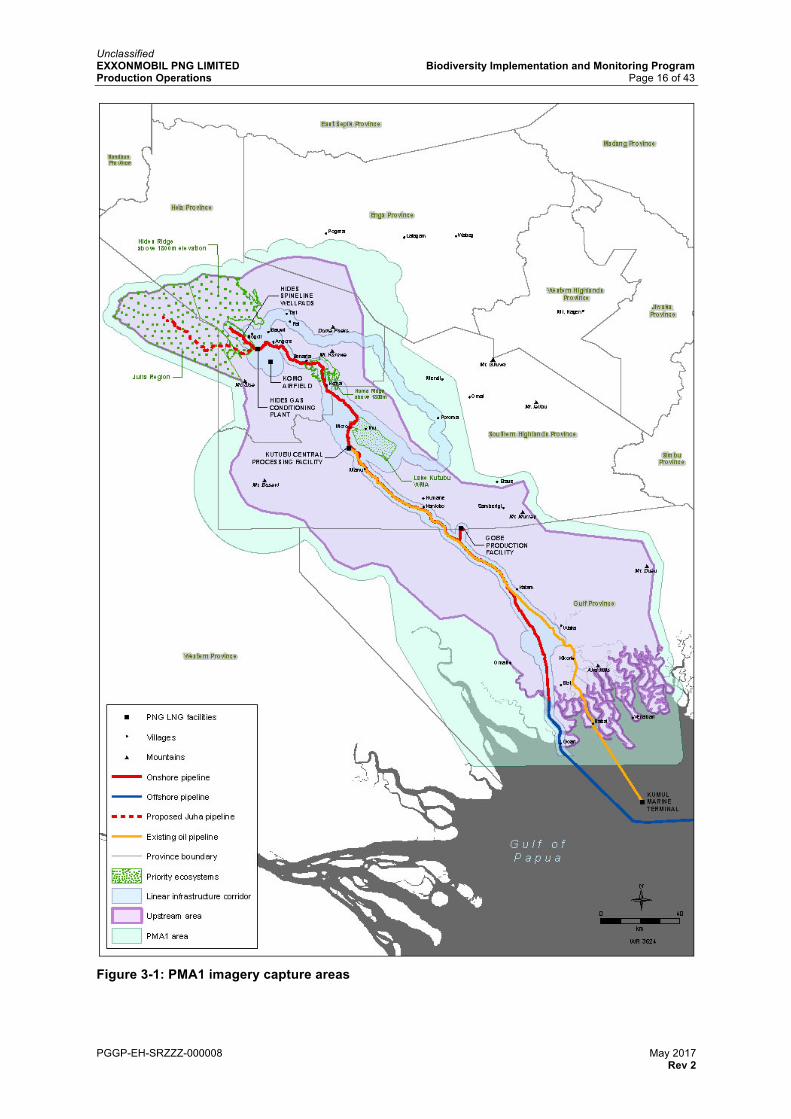
The PMA1 area encompasses the Upstream area plus an additional buffer zone, bringing the total area captured to 35,930 square kilometres, as shown in Figure 3-1.
PMA1 area assessments use moderate spatial resolution images acquired using Landsat satellite systems. Landsat imagery, with a spatial resolution equivalent to 30 metres, is appropriate to detect broadscale changes in land cover across the broader Upstream area. The PMA1 area also includes four areas identified as priority ecosystems, these are: Hides Ridge, Homa, Juha and the Lake Kutubu WMA.
The linear infrastructure corridor of 3950 square kilometres, which lies within the PMA1 area, has been defined to focus on PNG LNG operations, where change to land cover is expected
Unclassified EXXONMOBIL PNG LIMITED Biodiversity Implementation and Monitoring Program Production Operations Page 15 of 43
PGGP-EH-SRZZZ-000008 May 2017 Rev 2
due to construction and production, and specifically includes: PNG LNG facilities, the onshore pipeline Right of Way (ROW) and EMPNG roads and access tracks. Two priority ecosystems are wholly (Lake Kutubu WMA) or partially (Homa, 64 percent) encompassed within the linear infrastructure corridor. Surveys for the linear infrastructure corridors use high spatial resolution satellite imagery from the RapidEye satellite system. The RapidEye system is composed of five satellites and acquires image data with a spatial resolution equivalent to 5 metres.
Imagery obtained from both the Landsat and RapidEye systems is classified using an object-based algorithm to derive maps that delineate differences in land cover and land use types. The resulting maps are validated using an accuracy assessment. Data from each time period is analysed and compared to detect and measure changes in land cover features that were not shown in the baseline assessment. These changes are then assessed to determine whether any are directly or indirectly attributable to PNG LNG, and therefore represent a potential residual impact. An indicative level of significance (as defined in Table 2-1) will be provided where possible, but this may require ground-truthing. For example, should broadscale logging or agriculture activity be observed immediately adjacent to the pipeline ROW, or where access to such activity originates from the pipeline ROW or an EMPNG controlled road, the activity could potentially be related, or perceived/claimed to be related, to PNG LNG. EMPNG will then validate this through ground inspection as part of PMA2.
Further details regarding PMA1 are provided in the PMA1 Protocol.
3.1.4 Reporting
The output from each PMA1 campaign is a technical report originated by the PMA1 Contractor. This report provides information, supported by maps at an appropriate scale, documenting and describing land cover changes observed within the PMA1 area since the previous campaign, with an analysis of trends where applicable.
3.1.5 Frequency
Analyses of changes in land cover within the PMA1 area have been completed for 2009, 2011 and 2013. Landsat-derived data from 2009 was used to map changes to land cover before construction began. There is no RapidEye data for 2009. The 2011 and 2013 analysis of Landsat and RapidEye data was completed in 2015. Analysis of the 2015 dataset was completed in 2016.
Data collection, processing, analysis and reporting under PMA1 is undertaken every second year and findings summarised in the public PNG LNG Environmental and Social Report series. The scale and frequency of data collection may be reviewed subject to monitoring results.
Unclassified EXXONMOBIL PNG LIMITED Biodiversity Implementation and Monitoring Program Production Operations Page 16 of 43
PGGP-EH-SRZZZ-000008 May 2017 Rev 2
Figure 3-1: PMA1 imagery capture areas
Unclassified EXXONMOBIL PNG LIMITED Biodiversity Implementation and Monitoring Program Production Operations Page 17 of 43
PGGP-EH-SRZZZ-000008 May 2017 Rev 2
3.2 Programmed Monitoring Activity 2: Condition Surveys of Focal Habitats and Significant Ecological Features
3.2.1 Objectives
The focus of PMA2 is to assess the condition and ecological functionality of focal habitats and significant ecological features avoided during the construction of PNG LNG-related roads, the pipeline ROW and other relevant PNG LNG facilities and infrastructure.
Based on ongoing surveys of focal habitats and significant ecological features on the pipeline ROW and other PNG LNG facilities and infrastructure, PMA2 provides data to enable the evaluation of performance with regard to Objectives 2 and 3 of the Biodiversity Strategy.
KPIs relevant to PMA2 are shown in Table 3-2.
PMA2 work is primarily undertaken by EMPNG’s biodiversity advisors. Where a potentially moderate/high significant change of condition is observed, EMPNG may enlist expert opinion if required to help determine the ecological significance and estimate the years for recovery.
3.2.2 Baseline conditions
Focal habitats and significant ecological features within, and in the immediate vicinity of, the pipeline ROW and other PNG LNG facilities and infrastructure were identified during pre-construction surveys. The purpose of these surveys was to provide timely site-specific information to guide construction activities and enable avoidance, or the management of, potential impacts where feasible.
The scope of pre-construction surveys included focal habitats and significant ecological features (as noted in the Environment Permit), such as lekking trees or grounds for birds-of-paradise or bowerbirds, bat colonies, swamp forest and nothofagus forest.
Details of focal habitats and significant ecological features identified during the pre-construction survey program are maintained in a Focal Habitats and Significant Ecological Features Register and EMPNG’s Geographic Information System (GIS) database.
3.2.3 Method
During the production phase, management measures are applied where necessary to prevent impacts to focal habitats and significant ecological features, as detailed in the Environmental Management Plan: Upstream Facilities, Infrastructure and Pipelines. Focal habitats and significant ecological features are monitored as part of PMA2 to ensure that habitats avoided and/or reinstated remain in good condition.
Direct impacts to focal habitats and significant ecological features during normal operations are expected to be negligible, therefore the focus of ecological management during production is monitoring for potential indirect residual impacts from the construction phase, which may manifest, evolve or persist. Where there is evidence to conclude that there has been no impact on a specific focal habitat or significant ecological feature, and that none is likely, then monitoring will be scaled back and will ultimately cease. Similarly, where an impacted site has fully recovered, monitoring will cease. Where new or additional land beyond the construction footprint is required, a pre-disturbance survey of the area to be affected (similar in scope to the pre-construction surveys) will be undertaken.
The Initial Post Construction Biodiversity Assessment evaluated residual impacts to focal habitats and significant ecological features that occurred as a result of construction, that is, lost or degraded. It also evaluated focal habitats and significant ecological features that were avoided during construction and required ongoing monitoring in the production phase.
Not all focal habitats and significant ecological features identified as part of the pre-construction survey program and the Initial Post Construction Biodiversity Assessment
Unclassified EXXONMOBIL PNG LIMITED Biodiversity Implementation and Monitoring Program Production Operations Page 18 of 43
PGGP-EH-SRZZZ-000008 May 2017 Rev 2
require ongoing monitoring. Only those located in the immediate vicinity of the pipeline ROW and other PNG LNG facilities and infrastructure, or those that are otherwise potentially vulnerable to residual impacts that may evolve or manifest during production, need monitoring. Details of focal habitats and significant ecological features requiring ongoing monitoring are maintained in the Focal Habitats and Significant Ecological Features Register, which forms the basis of PMA2. EMPNG field environmental personnel oversee an ongoing program of routine inspections and monitoring activities, as well as PMA2-specific data collection.
Inspection and monitoring for PMA2 is being undertaken through a defined schedule of activities in accordance with a pre-determined protocol based on the Focal Habitats and Significant Ecological Features Register. Inspections consist of ground-based surveys for assessment and verification. Ground truthing of priority inspection zones identified in PMA1 will also be undertaken as part of PMA2 activities.
The output of PMA2 provides information on the condition of specific features of ecological significance so that changes from baseline conditions can be identified (Table 3-1). Any observed changes in condition are assessed according to criteria provided in, and an appropriate management response is undertaken, as described in Section 2.1.
Table 3-1: Focal habitats and significant ecological features monitoring criteria
FOCAL HABITATS AND SIGNIFICANT ECOLOGICAL FEATURES
EVALUATION OF CHANGES OF CONDITION
Caves and pinnacles Evidence of human interference, including recording evidence of trails leading to caves and footprints at cave entrances
Sinkhole swamps Evaluation of sinkhole swamps will include estimating water depth and cover of aquatic plants; recording evidence of human interference such as trails leading to the sinkhole swamp
Upland streams Evaluation of upland streams will include an assessment of the condition of riverine vegetation and evidence of erosion and/or sedimentation
Swamps and mangroves Evaluation of swamp forest and mangroves will include an assessment of the general condition of vegetation and evidence/cause of disturbance
Stream refuges in unstable landscapes2 Evaluation of stream refuges will include an assessment of the general condition of vegetation and evidence/cause of disturbance
Lowland rivers in stable landscapes Evaluation of lowland rivers will include an assessment of the condition of riverine vegetation and evidence of erosion and/or sedimentation
Off-river waterbodies Evaluation of off-river waterbodies will include an assessment of the general condition of vegetation and evidence/cause of disturbance
Flora, fauna and habitats of cultural significance
Evaluation will include an assessment of general condition of the culturally significant feature and evidence/cause of disturbance Evaluation will include cultural heritage features however subsistence features such as prey fauna species and harvest flora species will not be evaluated
Lekking trees or grounds Evaluation will include qualitative assessments of condition based on evidence of recent use or disturbance
2 Applicable to the Juha future phase of PNG LNG.
Unclassified EXXONMOBIL PNG LIMITED Biodiversity Implementation and Monitoring Program Production Operations Page 19 of 43
PGGP-EH-SRZZZ-000008 May 2017 Rev 2
3.2.4 Reporting
The output from each PMA2 campaign is a summary report. This report provides information, supported by appropriate data, which documents and evaluates the condition of focal habitats and significant ecological features avoided or mitigated during construction. A summary of the report will be provided in the public PNG LNG Environmental and Social Report series.
Further details regarding PMA2 are provided in the PMA2 Protocol.
3.2.5 Frequency
PMA2 is an ongoing program of regular inspections conducted in accordance with the frequency set out in the PMA2 Protocol. Evidence obtained during inspections will be used to assess the frequency and scope of future monitoring events at each focal habitat and/or significant ecological feature.
PMA3 is a program of terrestrial biodiversity surveys designed to collect and analyse data relating to trends in species diversity and abundance of flora and fauna in the Upstream area, as well as protected areas enhanced and/or established as part of the offset program in order to:
• ascertain the ongoing health of habitats, flora and fauna to ensure any negative impacts associated with EMPNG are identified and managed
• monitor the health and condition of the biological values of protected areas forming part of the offset program
• provide data to enable the evaluation of performance for Objectives 1, 2 and 4 of the Biodiversity Strategy.
KPIs relevant to PMA3 are shown in Table 3-2.
PMA3 requires appropriate technical expertise, and therefore a specialist organisation, namely the PMA3 Contractor, has been engaged to perform the required tasks.
3.3.2 Baseline Conditions
The first PMA3 biodiversity surveys were conducted during 2015 in two Biodiversity Assessment Areas (BAA), one established at Hides Ridge (BAA 1) and the other on the Agogo Range near Moro (BAA 2). These BAAs were delineated following a review of data collected from a range of biodiversity studies, as described in the Biodiversity Strategy, and including the EIS (Esso Highlands Limited, 2009), and pre-construction surveys.
3.3.3 Method
There is no single species or group that could be used as an indicator across the range of biodiversity values identified for the Upstream area, and therefore EMPNG considers that systematic biodiversity assessments represent the most effective way to monitor these values. Efficiency of monitoring requires adapting and evolving techniques to local circumstances, and changing the bias of methods in real time to maximise the chances of recording as many species as possible in the time available.
PMA3 uses modified RAP assessment field surveys to collect quantitative, repeatable data on species presence for monitoring of biodiversity in and around the areas affected by PNG LNG, and in protected areas established or enhanced as part of EMPNG’s offset program. To achieve repeatability, biodiversity surveys are being conducted across monitoring
Unclassified EXXONMOBIL PNG LIMITED Biodiversity Implementation and Monitoring Program Production Operations Page 20 of 43
PGGP-EH-SRZZZ-000008 May 2017 Rev 2
transects broadly grouped into Biodiversity Assessment Areas representative of areas where EMPNG has infrastructure.
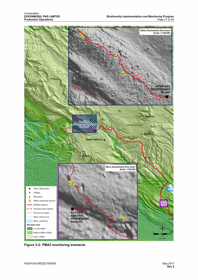
PMA3 work scope includes:
• two Biodiversity Assessment Areas (as shown in Figure 3-2) established at:
• Hides Ridge including six monitoring transects to represent high-altitude ecosystems
• near Moro, on the Agogo Range, including five monitoring transects to represent medium-altitude ecosystems
• protected areas enhanced and/or established as part of the offset program.
Additional Biodiversity Assessment Areas may be established in the future, if required, to sample low-altitude ecosystems where EMPNG has infrastructure.
Sampling and development of species inventories are conducted using a range of quantitative and repeatable techniques that enable appropriate comparisons between sampling periods. Most sampling is conducted on standardised transects with sampling points at increasing distances into the forest from the edge of a PNG LNG road or ROW. Core fauna sample groups for PMA3 include native rodents, invasive rodents, bats, birds-of-paradise and frogs. Details of field techniques for each group of fauna are provided in the PMA3 Protocol. For flora sampling, permanent plots will be laid out to monitor changes in plant diversity and vegetation structure over time. Further details on the fauna and flora monitoring methods are also provided in the PMA3 Protocol.
Field surveys are designed to assess species diversity, and to identify candidate species for monitoring of population changes.
3.3.4 Reporting
Data on species occurrence and abundance will permit assessment and reporting of:
• total species richness at each site for each taxon group • changes in species richness at each site over time • changes in community composition over time (e.g. are disturbance-tolerant species
becoming a larger proportion of the community, even if total diversity remains the same or is increasing)
• changes in abundance of target species over time (for example IUCN-listed species or Papua New Guinea protected) identified for monitoring during the first field survey
• differences between changes in species diversity and abundance (if any) documented at sites close to, and away from, the pipeline ROW and roads over time
• the colonisation of invasive species, with a particular focus on rodents.
The output from each PMA3 campaign is a technical report, compiled by the PMA3 Contractor, which provides information describing the biodiversity surveys conducted and their findings. The report will provide an assessment of the general condition of forest in the Biodiversity Assessment Areas. It will also describe, and provide expert advice on the significance of, any trends in species diversity, component species, and species abundance that are not within normal expected variation and that are likely to be attributable, directly or indirectly, to EMPNG. Where appropriate PMA3 Contractor will provide advice on appropriate actions to mitigate any ongoing impacts on flora and fauna. A summary will be provided in the PNG LNG Environmental and Social Report series.
3.3.5 Frequency
Data collection, processing, analysis and reporting under PMA3 started in 2015 and is undertaken every other year. Additional and/or more frequent surveys may be undertaken as required.
Unclassified EXXONMOBIL PNG LIMITED Biodiversity Implementation and Monitoring Program Production Operations Page 21 of 43
PGGP-EH-SRZZZ-000008 May 2017 Rev 2
Figure 3-2: PMA3 monitoring transects
Unclassified EXXONMOBIL PNG LIMITED Biodiversity Implementation and Monitoring Program Production Operations Page 22 of 43
PGGP-EH-SRZZZ-000008 May 2017 Rev 2
Table 3-2: Monitoring system for Objectives 1, 2 and 3 of the Biodiversity Strategy
BIODIVERSITY STRATEGY OBJECTIVE
BIODIVERSITY VALUE KPI PERFORMANCE INDICATOR MONITORING PROGRAM
DATA/MEASUREMENT
1. MAINTAIN THE INTACTNESS OF THE UPSTREAM AREA AS A WHOLE
The long-term maintenance of biodiversity in the Upstream area, within a natural range of variation, requires the long-term functioning of the constituent ecosystems
LARGE SCALE: THE ENTIRE UPSTREAM AREA
Extensive intact forest
The Upstream area encompasses large expanses of largely undisturbed tropical forest
1 – Intactness of forest
No evidence of broadscale forest loss or degradation attributable to PNG LNG
Forest cover derived from satellite imagery expressed as a percentage
High floristic diversity
Between 6000 and 12,000 species of plants may exist in the Upstream area, with epiphytes making up 75 percent of floristic diversity in upland forests
2 – Trends in species diversity and abundance
No evidence or trend indicating a decline of floristic diversity, or a shift in species composition, attributable to PNG LNG
PMA3 Species inventory (types, diversity and abundance of floristic species)
High faunal diversity
Over 700 species of terrestrial vertebrates have been recorded to date
2 – Trends in species diversity and abundance
No evidence or trend indicating a decline of faunal diversity, abundance of target species, or a shift in species composition attributable to PNG LNG
PMA3 Species inventory (types, diversity and abundance of faunal species)
Endemic species
75 percent of non-volant mammals, 40 percent of birds and over 90 percent of frogs found in the upstream area are endemic to New Guinea.
2 – Trends in species diversity and abundance
No evidence or trend indicating a decline of endemic diversity, or abundance of target endemic species, attributable to PNG LNG
PMA3 Species inventory (types, diversity and abundance of endemic species)
Unique assemblages of species
The Upstream area is recognised for its high diversity of birds-of-paradise and amphibians
2 – Trends in species diversity and abundance
No evidence or trend indicating a decline of component species, attributable to PNG LNG
PMA3 Species inventory (types, diversity and abundance of species)
Unclassified EXXONMOBIL PNG LIMITED Biodiversity Implementation and Monitoring Program Production Operations Page 23 of 43
PGGP-EH-SRZZZ-000008 May 2017 Rev 2
BIODIVERSITY STRATEGY OBJECTIVE
BIODIVERSITY VALUE KPI PERFORMANCE INDICATOR MONITORING PROGRAM
DATA/MEASUREMENT
Species of conservation concern
Species of plants and animals classified by the IUCN as Critically Endangered or Endangered, or protected under Papua New Guinean legislation, are located in the Upstream area
2 – Trends in species diversity and abundance
No evidence or trend indicating decline of Endangered or Critically Endangered species attributable to PNG LNG
PMA3 Species inventory (type, and abundance of Endangered/Critically Endangered species)
Biodiversity of importance to local communities for resource use and/or cultural and spiritual purposes
Communities are linked to biodiversity values through their reliance on subsistence harvesting and a close physical and spiritual relationship to ancestral territories
This value is addressed through the offset program by undertaking an ecosystems services analysis to determine biodiversity values of importance to local communities and includes protection of these as part of the new and/or enhanced WMA(s)
2. CONSERVE PRIORITY ECOSYSTEMS
Some PNG LNG infrastructure is located within priority ecosystems, and therefore it is necessary to demonstrate that these ecosystems do not degrade as a result of construction and/or production activities
MEDIUM SCALE: PRIORITY ECOSYSTEMS
Forest in the Hides Ridge area: The high-altitude nothofagus forest on karst above 1800 metres harbours a diverse montane fauna in a largely undisturbed tropical forest. Biological values are naturally maintained by the remoteness and difficulty of access
Largely undisturbed forest 1 – Intactness of forest
No evidence of broadscale forest loss or degradation attributable to PNG LNG
PMA1, EMP Access Control
Forest cover derived from satellite imagery expressed as a percentage
Epiphytes and ferns are a major component of plant biodiversity
2 – Trends in species diversity and abundance
No evidence or trend indicating a decline of epiphyte and fern diversity or abundance attributable to PNG LNG
PMA3 Species inventory (types, diversity and abundance of flora species)
Unique assemblages of plants 2 – Trends in species diversity and abundance
No evidence or trend indicating a decline of floristic diversity or abundance, or a shift in species composition, attributable to PNG LNG
PMA3 Species inventory (types, diversity and abundance of flora species)
Unclassified EXXONMOBIL PNG LIMITED Biodiversity Implementation and Monitoring Program Production Operations Page 24 of 43
PGGP-EH-SRZZZ-000008 May 2017 Rev 2
BIODIVERSITY STRATEGY OBJECTIVE
BIODIVERSITY VALUE KPI PERFORMANCE INDICATOR MONITORING PROGRAM
DATA/MEASUREMENT
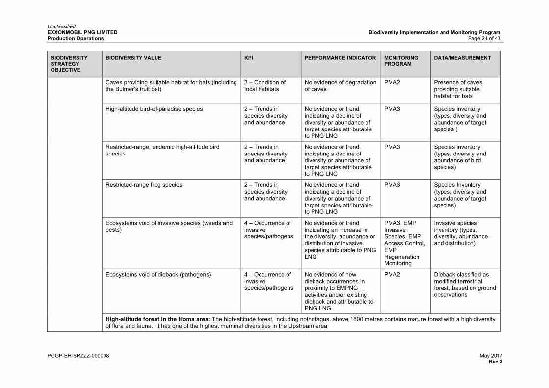
Caves providing suitable habitat for bats (including the Bulmer’s fruit bat)
3 – Condition of focal habitats
No evidence of degradation of caves
PMA2 Presence of caves providing suitable habitat for bats
High-altitude bird-of-paradise species 2 – Trends in species diversity and abundance
No evidence or trend indicating a decline of diversity or abundance of target species attributable to PNG LNG
PMA3 Species inventory (types, diversity and abundance of target species )
Restricted-range, endemic high-altitude bird species
2 – Trends in species diversity and abundance
No evidence or trend indicating a decline of diversity or abundance of target species attributable to PNG LNG
PMA3 Species inventory (types, diversity and abundance of bird species)
Restricted-range frog species 2 – Trends in species diversity and abundance
No evidence or trend indicating a decline of diversity or abundance of target species attributable to PNG LNG
PMA3 Species Inventory (types, diversity and abundance of target species)
Ecosystems void of invasive species (weeds and pests)
4 – Occurrence of invasive species/pathogens
No evidence or trend indicating an increase in the diversity, abundance or distribution of invasive species attributable to PNG LNG
Invasive species inventory (types, diversity, abundance and distribution)
Ecosystems void of dieback (pathogens)
4 – Occurrence of invasive species/pathogens
No evidence of new dieback occurrences in proximity to EMPNG activities and/or existing dieback and attributable to PNG LNG
PMA2 Dieback classified as modified terrestrial forest, based on ground observations
High-altitude forest in the Homa area: The high-altitude forest, including nothofagus, above 1800 metres contains mature forest with a high diversity of flora and fauna. It has one of the highest mammal diversities in the Upstream area
Unclassified EXXONMOBIL PNG LIMITED Biodiversity Implementation and Monitoring Program Production Operations Page 25 of 43
PGGP-EH-SRZZZ-000008 May 2017 Rev 2
BIODIVERSITY STRATEGY OBJECTIVE
BIODIVERSITY VALUE KPI PERFORMANCE INDICATOR MONITORING PROGRAM
DATA/MEASUREMENT
Largely undisturbed forest 1 – Intactness of forest
No evidence of broadscale forest loss or degradation attributable to PNG LNG
PMA1, EMP Access Control
Forest cover derived from satellite imagery expressed as a percentage
High floristic diversity 2 – Trends in species diversity and abundance
No evidence or trend indicating a decline of floristic diversity or a shift in species composition, attributable to PNG LNG
PMA3 Species inventory (types, diversity and abundance of floristic species)
High faunal diversity 2 – Trends in species diversity and abundance
No evidence or trend indicating a decline of faunal diversity, or abundance of target species, or a shift in species composition, attributable to PNG LNG
PMA3 Species inventory (types, diversity and abundance of faunal species)
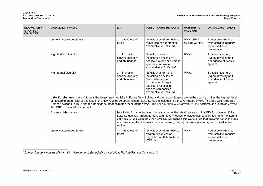
Lake Kutubu area: Lake Kutubu is the largest perched lake in Papua New Guinea and the second largest lake in the country. It has the highest level of lacustrine endemicity of any lake in the New Guinea-Australia region. Lake Kutubu is included in the Lake Kutubu WMA. The lake was listed as a Ramsar3 wetland in 1998 and the Ramsar boundaries match those of the WMA. The Lake Kutubu WMA covers 25,455 hectares and is the only WMA that PNG LNG facilities intersect
Endemic fish species Monitoring fish species is not currently part of the offset program or this BIMP. However, if the Lake Kutubu WMA management committee chooses to include fish conservation and monitoring activities in their work plan then EMPNG will support this work. Note that endemic fish in the lake are threatened by non-native fish species (e.g. tilapia) that were previously introduced to the region
Largely undisturbed forest 1 – Intactness of forest
No evidence of broadscale swamp forest loss or degradation attributable to PNG LNG
PMA1 Forest cover derived from satellite imagery expressed as a percentage
3 Convention on Wetlands of International Importance Especially as Waterfowl Habitat (Ramsar Convention).
Unclassified EXXONMOBIL PNG LIMITED Biodiversity Implementation and Monitoring Program Production Operations Page 26 of 43
PGGP-EH-SRZZZ-000008 May 2017 Rev 2
BIODIVERSITY STRATEGY OBJECTIVE
BIODIVERSITY VALUE KPI PERFORMANCE INDICATOR MONITORING PROGRAM
DATA/MEASUREMENT
Forest in the Juha area: Juha is a remote region where there has been little human influence on the vegetation and fauna, and its ecological values are maintained primarily by its difficulty of access. Among biodiversity values specifically represented in this area, Juha contains notable concentrations of unique assemblages of frog species. The Juha development is a future phase of PNG LNG.
3. PROTECT FOCAL HABITATS
Focal habitats and significant ecological features have been avoided or otherwise managed during construction, and in production, so that the risks of reducing a population of Critically Endangered or Endangered species are as low as practicable
SMALL SCALE: FOCAL HABITATS
Caves and pinnacles
Provide important habitats for certain bat species such as the Critically Endangered New Guinea big-eared bat (Pharotis imogene), and caves with large entrances in the upland area support colonies of large bats, potentially including the Critically Endangered Bulmer’s fruit-bat (Aproteles bulmerae)
3 – Condition of focal habitats
No evidence of degradation of caves attributable to PNG LNG
PMA2 Condition of caves
Sinkhole swamps
Microhabitats at the bottom of dolines, including swamps in sinkholes less than 50 metres deep, in high-altitude karst on Hides Ridge, the only habitats where water-dependent frogs can breed in karst, which tends to have few flowing streams
3 – Condition of focal habitats
No evidence of degradation of sinkhole swamps attributable to PNG LNG
PMA2 Condition of sinkhole swamps
Upland streams
Torrent-dwelling frogs require fast-flowing, clear and rocky streams. Riparian vegetation along such streams supports birds such as Salvadori’s teal (Salvadorina waigiuensis) and the torrent-lark (Grallina bruijni)
3 – Condition of focal habitats
No evidence or trend of degradation of upland streams attributable to PNG LNG
PMA2 Condition of upland streams
Unclassified EXXONMOBIL PNG LIMITED Biodiversity Implementation and Monitoring Program Production Operations Page 27 of 43
PGGP-EH-SRZZZ-000008 May 2017 Rev 2
BIODIVERSITY STRATEGY OBJECTIVE
BIODIVERSITY VALUE KPI PERFORMANCE INDICATOR MONITORING PROGRAM
DATA/MEASUREMENT
Swamps and mangroves
Including areas of pandanus, sago swamp forest or mangroves, support a range of specialist vertebrates, including the twelve-wired bird-of-paradise (Seleucidis melanoleuca), and the New Guinea flightless rail (Megacrex inepta). Swamp forests may provide an important breeding habitat for freshwater turtles and crocodiles. High-value conservation swamps in the Lower Kikori contain habitats for fish nurseries
3 – Condition of focal habitats
No evidence or trend of degradation of swamp forest or mangroves attributable to PNG LNG
PMA2
Condition of swamp forest and mangroves
Stream refuges in unstable landscapes
In unstable terrain where landslides are common, areas of more mature habitat on pockets of more stable substrates such as in stream heads or small plateaus can act as refuges for flora and fauna
3 – Condition of focal habitats
No evidence of degradation of stream refuges in unstable landscapes attributable to PNG LNG
PMA2 Condition of stream refuges in unstable landscapes
Lowland rivers in stable landscapes
Provide habitat for crocodiles and freshwater turtles, and some bird species are abundant, including kingfishers and shining flycatchers (Myiagra alecto)
3 – Condition of focal habitats
No evidence of degradation of lowland rivers in stable landscapes attributable to PNG LNG
PMA2 Condition of lowland rivers in stable landscapes
Off-river waterbodies
Stable habitat type that provides refuge areas and offers habitat for the breeding of New Guinea freshwater crocodiles (Crocodylus novaeguineae). It is created by localised damming of runoff by landslides
3 – Condition of focal habitats
No evidence of degradation of off-river waterbodies attributable to PNG LNG
PMA2 Condition of off-river waterbodies
Unclassified EXXONMOBIL PNG LIMITED Biodiversity Implementation and Monitoring Program Production Operations Page 28 of 43
PGGP-EH-SRZZZ-000008 May 2017 Rev 2
BIODIVERSITY STRATEGY OBJECTIVE
BIODIVERSITY VALUE KPI PERFORMANCE INDICATOR MONITORING PROGRAM
DATA/MEASUREMENT
Flora, fauna and habitats of cultural significance
Culturally significant areas, habitats and species occur throughout and surrounding settled areas in the Upstream area, varying from small swamps said to harbour spirits, to places where medicinal plants are harvested
3 – Condition of focal habitats
No evidence of degradation of habitats, flora and fauna of cultural significance attributable to PNG LNG
PMA2 Condition of habitats, flora and fauna of cultural significance
Lekking trees or grounds
Bird-of-paradise or bowerbird display trees or grounds
3 – Condition of focal habitats
No evidence of degradation of lekking trees or grounds attributable to PNG LNG
PMA2 Condition of lekking trees or grounds
Unclassified EXXONMOBIL PNG LIMITED Biodiversity Implementation and Monitoring Program Production Operations Page 29 of 43
PGGP-EH-SRZZZ-000008 May 2017 Rev 2
4.0 OFFSET PROGRAM IMPLEMENTATION AND MONITORING The offset program involves two phases – implementation and monitoring. Many of the work activities that make up the two phases are inter-linked, iterative and will proceed in parallel.
4.1 Offset program implementation The offset program consists of five components:
• Component 1: Protected area planning – Support the Papua New Guinea Conservation and Environment Protection Authority (CEPA) in the development of a Protected Area System Plan for the Kikori River Basin.
• Component 2: Support the national biodiversity strategy – Support CEPA in enhancing implementation of the National Biodiversity Strategy and Action Plan (NBSAP).
• Component 3: Build conservation capacity – Build technical capacity by contributing to the expansion of a training system aimed at developing qualified professionals across a range of disciplines that relate to the offset program.
• Component 4: Enhance existing protected areas – Enhance and strengthen the operation of existing WMAs in the Upstream area.
• Component 5: Establish new protected areas – Establish new community-based protected areas in the Upstream area that are representative of the biodiversity values recognised by EMPNG.
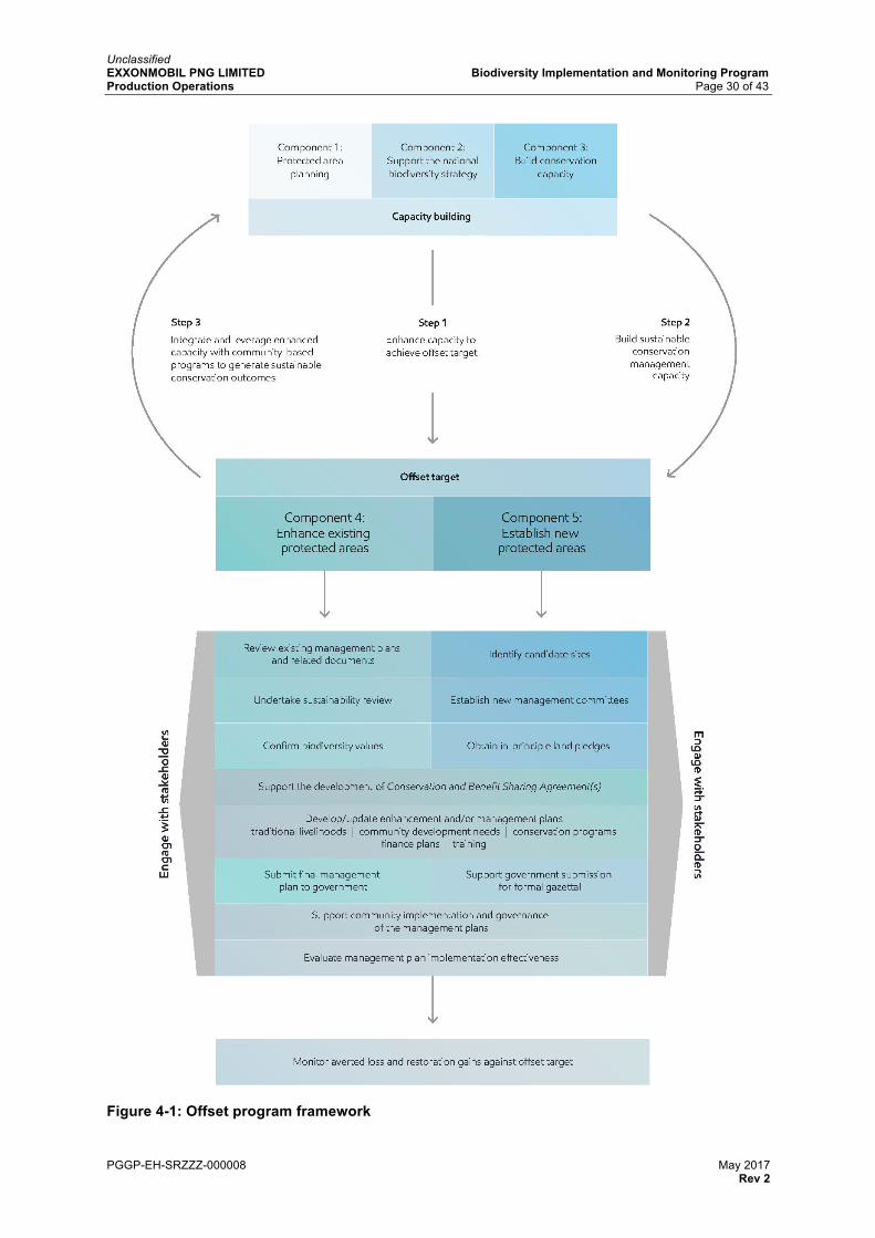
Components 1, 2 and 3 provide the foundation for capacity building to support the sustainability of protected areas (Components 4 and 5). Components 1, 2 and 3 are, by their nature, discrete programs that cease when their endpoints have been reached. Components 4 and 5 form the core of the offset program as they define the sites where the averted losses and potentially restoration of degraded areas will occur, and monitor the ecological integrity of the offset programs to verify averted losses and restoration gains, and hence the objective of achieving the offset target. Figure 4-1 illustrates the integration of the offset program components.
Implementation of the five components of the offset program enables Objective 4 of the Biodiversity Strategy to be met.
EMPNG is progressing work for each of the components with participation from experienced community liaison professionals (including from within EMPNG and in association with an experienced external organisation). It also involves support from specialist biodiversity consultants, and partnerships with conservation-focused non-government organisations (NGOs), or a collaboration of conservation-focused NGOs and other relevant entities.
Unclassified EXXONMOBIL PNG LIMITED Biodiversity Implementation and Monitoring Program Production Operations Page 30 of 43
PGGP-EH-SRZZZ-000008 May 2017 Rev 2
Figure 4-1: Offset program framework
Unclassified EXXONMOBIL PNG LIMITED Biodiversity Implementation and Monitoring Program Production Operations Page 31 of 43
PGGP-EH-SRZZZ-000008 May 2017 Rev 2
4.1.1 Component 1
Implementation of Component 1 involves collaboration with CEPA to refine and extend the work done to date to identify conservation priorities for a Protected Area System Plan for the Kikori River Basin. Data generated by Component 1 will be used by CEPA to support the establishment of legally binding agreements and formal management structures for the Kikori River Basin. CEPA is working to achieve recognition of the Kikori River Basin as a World Heritage site under the Convention for the Protection of the World Cultural and Natural Heritage.
EMPNG is delivering Component 1 through partnership with conservation NGOs.
Work activities associated with the delivery of this component are summarised in Table 4-1. Table 4-1: Component 1 work activities
WORK ACTIVITIES
I Prepare work scope and undertake supporting administrative tasks including consultation with CEPA
II Conduct preliminary research and data preparation covering conservation prioritisation work done to date in the Kikori River Basin
ITER
ATIV
E PR
OC
ESS
III Establish a single GIS-based biodiversity database containing consolidated data for the Kikori River Basin
IV Develop stakeholder and community engagement strategies that define relevant stakeholders and the purpose and scope of engagement
V Develop a report comprising an analysis, narrative and maps as appropriate, to document the evaluation of constraints, opportunities and options that would bear on a protected area system in the Kikori River Basin
VI Conduct stakeholder workshop(s) to gather feedback and recommendations on the Protected Area System Plan
VII Develop a document that establishes the framework for a protected area system for the Kikori River Basin
VIII Finalise the Protected Area System Plan with endorsement from CEPA and provincial governments
Implementation of Component 1 is expected to be completed toward the end of 2018/early 2019.
4.1.2 Component 2
Component 2 involves supporting CEPA in enhancing its implementation of part of the NBSAP. EMPNG is working with CEPA, and an NGO, to improve communications and collaboration between the scientific community and relevant stakeholders about conservation best practices using tools such as conservation meetings, conferences and regular newsletters.
Work activities associated with the delivery of Component 2 are summarised in Table 4-2. Table 4-2: Component 2 work activities
WORK ACTIVITIES
I Form a work group between EMPNG and conservation NGO(s) to assist CEPA communications of best management practices in protected areas
II Develop and distribute quarterly newsletters to share information on best management practices relating to biodiversity topics
III Conduct biannual conservation meetings to share information on best management practices relating to biodiversity topics
Unclassified EXXONMOBIL PNG LIMITED Biodiversity Implementation and Monitoring Program Production Operations Page 32 of 43
PGGP-EH-SRZZZ-000008 May 2017 Rev 2
WORK ACTIVITIES
IV Conduct two biology conferences to share information on best management practices relating to biodiversity topics
V Identify sponsors to continue ongoing work designed to support communication of conservation programs
EMPNG’s involvement in the implementation of Component 2 work activities will be completed at the end of 2018. Component 2 therefore also involves engagement with the NGO community to identify sponsors who can continue to work with CEPA to sustain these conservation community aspects of the NBSAP program.
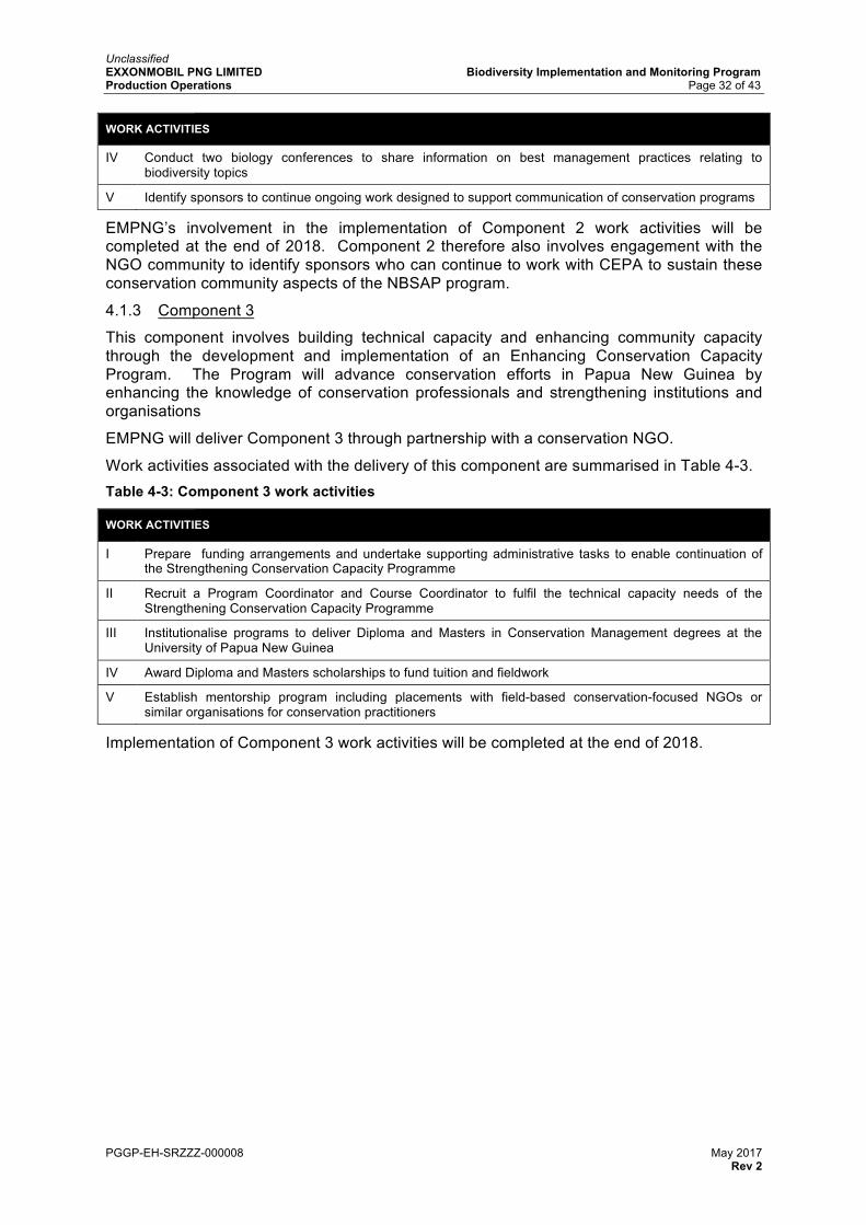
4.1.3 Component 3
This component involves building technical capacity and enhancing community capacity through the development and implementation of an Enhancing Conservation Capacity Program. The Program will advance conservation efforts in Papua New Guinea by enhancing the knowledge of conservation professionals and strengthening institutions and organisations
EMPNG will deliver Component 3 through partnership with a conservation NGO.
Work activities associated with the delivery of this component are summarised in Table 4-3. Table 4-3: Component 3 work activities
WORK ACTIVITIES
I Prepare funding arrangements and undertake supporting administrative tasks to enable continuation of the Strengthening Conservation Capacity Programme
II Recruit a Program Coordinator and Course Coordinator to fulfil the technical capacity needs of the Strengthening Conservation Capacity Programme
III Institutionalise programs to deliver Diploma and Masters in Conservation Management degrees at the University of Papua New Guinea
IV Award Diploma and Masters scholarships to fund tuition and fieldwork
V Establish mentorship program including placements with field-based conservation-focused NGOs or similar organisations for conservation practitioners
Implementation of Component 3 work activities will be completed at the end of 2018.
Unclassified EXXONMOBIL PNG LIMITED Biodiversity Implementation and Monitoring Program Production Operations Page 33 of 43
PGGP-EH-SRZZZ-000008 May 2017 Rev 2
4.1.4 Component 4
Component 4 involves the development and implementation of a Lake Kutubu WMA enhancement plan, which establishes the basis for the medium elevation zone element of the offset program. As shown in Figure 4-2, it also includes the development of a Neiru (Aird Hills) WMA enhancement plan, which establishes the basis for the low elevation zone element of the offset program.
Figure 4-2: Component 4 Wildlife Management Areas
Component 4 follows a series of work activities that are common to both the Lake Kutubu and Neiru (Aird Hills) WMAs, as shown in Table 4-4. Many of these work activities overlap due to the need to work through representative community groups, such as management committees, and the inter-related nature of the activities and their various feedback mechanisms. Table 4-4: Component 4 work activities
WORK ACTIVITIES
I Engage with stakeholders
Engage with local communities, relevant management committees, wards, ward development committees, local-level government, provincial government, CEPA and other interested parties
II Review existing management plans and related documents
Documents for review include those prepared in support of the original gazettal (e.g. biodiversity and socioeconomic baseline studies) and those prepared following gazettal
Unclassified EXXONMOBIL PNG LIMITED Biodiversity Implementation and Monitoring Program Production Operations Page 34 of 43
PGGP-EH-SRZZZ-000008 May 2017 Rev 2
WORK ACTIVITIES
III Undertake sustainability review
Review existing management and organisational structures, plans, programs and priorities; community capacity, motivation and support; ecological and financial viability; community development needs and opportunities (e.g. health, education and skills development); and opportunities for enhancement
IV Confirm biodiversity values
Confirm biodiversity values via surveys
V Support the development of Conservation and Benefit Sharing Agreement(s)
Support the development of Conservation and Benefit Sharing Agreement(s) that recognise(s) the right of customary landowners to use their biological resources in accordance with their traditional cultural practices, while ensuring the conservation and sustainable management of their resources
VI Develop/update enhancement and/or management plans
In conjunction with the management committees, develop/update enhancement and/or management plans to potentially include: • support for traditional livelihoods • ecosystem services analysis • community development needs • conservation programs • sustainable and equitable financing plans and instruments • training, support and empowerment of communities, customary landowners
and protected area staff to sustainably manage the protected areas (ongoing process)
• roles and responsibilities • monitoring and reporting
VII Submit final management plan to government
Final management plan submission to CEPA for inclusion in the National Protected Area Network
VIII Support community implementation and governance of the management plans
Support implementation through government and non-government partnerships and ongoing monitoring and evaluation programs that focus on the following indicators: • sustainable finance mechanisms • effective governance of the WMA • achievement of conservation objectives
4.1.5 Component 5
Component 5 involves the establishment of new legally gazetted protected areas and the development of management plans to support the governance of these areas.
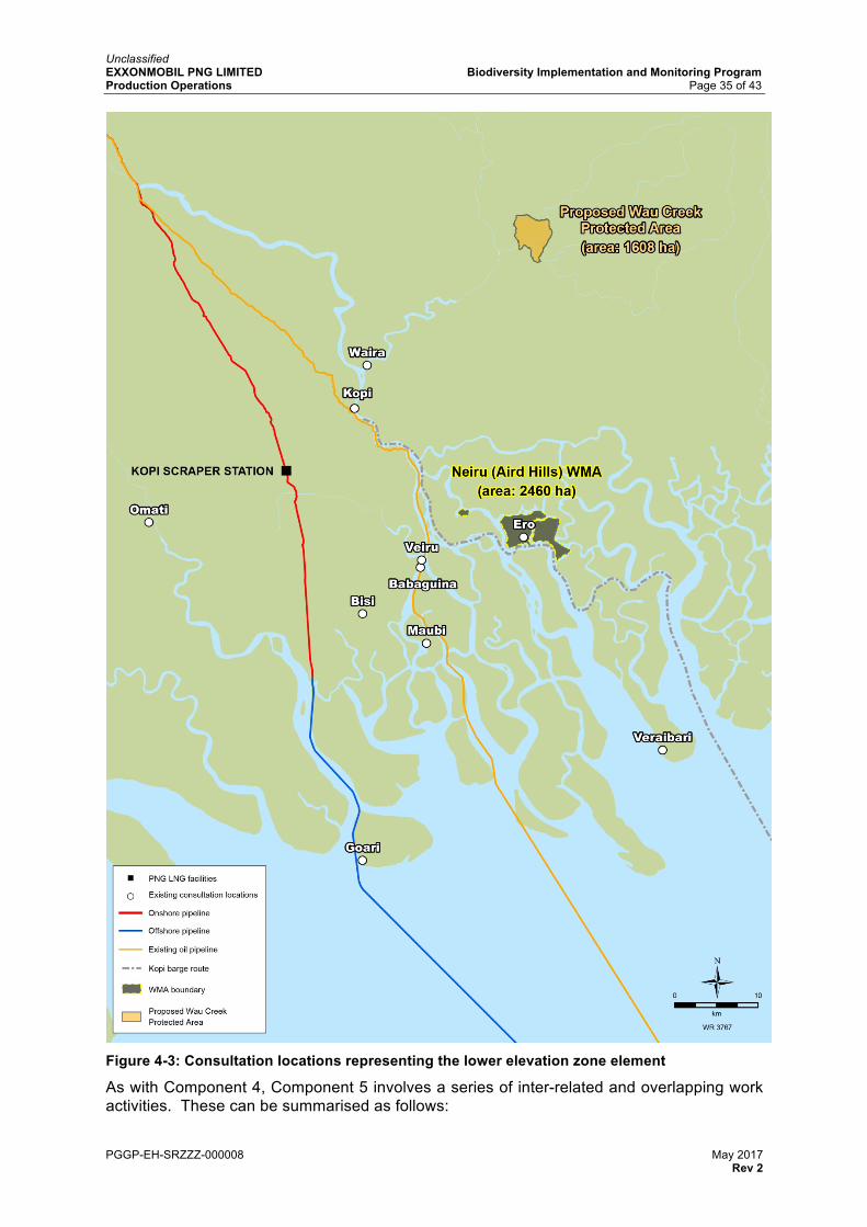
The existing Neiru (Aird Hills) WMA in the Kikori River delta area consists of three separate, non-contiguous areas. An option to create a new protected area that joins the existing WMA areas, and the proposed Wau Creek Protected Area, into one contiguous protected area is being evaluated. At this stage, the option is conceptual, but if agreed it could form part of Component 5, representing the lower elevation zone element of the offset program. The consultation locations for the lower elevation zone element of the offset program are shown in Figure 4-3.
The evaluation of candidate sites for new protected areas in the high elevation zone element of the offset program is ongoing.
Unclassified EXXONMOBIL PNG LIMITED Biodiversity Implementation and Monitoring Program Production Operations Page 35 of 43
PGGP-EH-SRZZZ-000008 May 2017 Rev 2
Figure 4-3: Consultation locations representing the lower elevation zone element
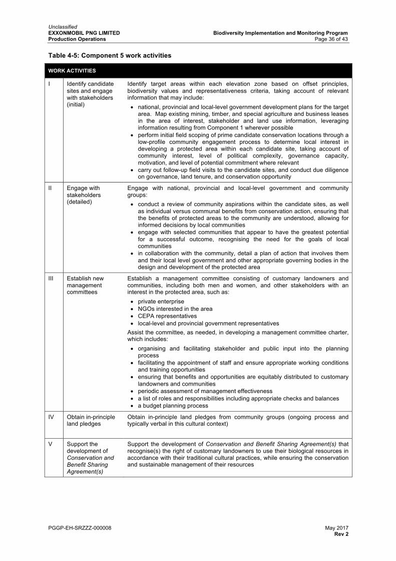
As with Component 4, Component 5 involves a series of inter-related and overlapping work activities. These can be summarised as follows:
Unclassified EXXONMOBIL PNG LIMITED Biodiversity Implementation and Monitoring Program Production Operations Page 36 of 43
PGGP-EH-SRZZZ-000008 May 2017 Rev 2
Table 4-5: Component 5 work activities
WORK ACTIVITIES
I Identify candidate sites and engage with stakeholders (initial)
Identify target areas within each elevation zone based on offset principles, biodiversity values and representativeness criteria, taking account of relevant information that may include: • national, provincial and local-level government development plans for the target
area. Map existing mining, timber, and special agriculture and business leases in the area of interest, stakeholder and land use information, leveraging information resulting from Component 1 wherever possible
• perform initial field scoping of prime candidate conservation locations through a low-profile community engagement process to determine local interest in developing a protected area within each candidate site, taking account of community interest, level of political complexity, governance capacity, motivation, and level of potential commitment where relevant
• carry out follow-up field visits to the candidate sites, and conduct due diligence on governance, land tenure, and conservation opportunity
II Engage with stakeholders (detailed)
Engage with national, provincial and local-level government and community groups: • conduct a review of community aspirations within the candidate sites, as well
as individual versus communal benefits from conservation action, ensuring that the benefits of protected areas to the community are understood, allowing for informed decisions by local communities
• engage with selected communities that appear to have the greatest potential for a successful outcome, recognising the need for the goals of local communities
• in collaboration with the community, detail a plan of action that involves them and their local level government and other appropriate governing bodies in the design and development of the protected area
III Establish new management committees
Establish a management committee consisting of customary landowners and communities, including both men and women, and other stakeholders with an interest in the protected area, such as: • private enterprise • NGOs interested in the area • CEPA representatives • local-level and provincial government representatives
Assist the committee, as needed, in developing a management committee charter, which includes: • organising and facilitating stakeholder and public input into the planning
process • facilitating the appointment of staff and ensure appropriate working conditions
and training opportunities • ensuring that benefits and opportunities are equitably distributed to customary
landowners and communities • periodic assessment of management effectiveness • a list of roles and responsibilities including appropriate checks and balances • a budget planning process
IV Obtain in-principle land pledges
Obtain in-principle land pledges from community groups (ongoing process and typically verbal in this cultural context)
V Support the development of Conservation and Benefit Sharing Agreement(s)
Support the development of Conservation and Benefit Sharing Agreement(s) that recognise(s) the right of customary landowners to use their biological resources in accordance with their traditional cultural practices, while ensuring the conservation and sustainable management of their resources
Unclassified EXXONMOBIL PNG LIMITED Biodiversity Implementation and Monitoring Program Production Operations Page 37 of 43
PGGP-EH-SRZZZ-000008 May 2017 Rev 2
WORK ACTIVITIES
VI Support the development of a management plan
Support the management committee with the development of a draft management plan and, following feedback from relevant stakeholders, develop a final management plan. The final management plan is to be based on the Papua New Guinea Policy on Protected Areas (Independent State of Papua New Guinea, 2014), which may include assessments such as: • detailed analysis of tenure and inheritance systems (including understanding of
custom, local historical timeline and genealogy) in order to define those who need to be part of the decision making process.
• biodiversity baseline assessment and characterisation of biological values • socioeconomic baseline assessment, with a focus on community development
The final management plan may include: • description of conservation objectives and programs • definition of protected area boundaries and internal zoning plans, including
areas designated for everyday use, restricted use and no go zones • community development needs • a stakeholder engagement plan • support for traditional livelihoods • training needs that will support and empower communities, customary
landowners and protected area staff to sustainably manage the protected areas • roles and responsibilities, • finance plan and instruments that are sustainable and equitable • monitoring and reporting
VII Support government submission for formal gazettal
Support the preparation of necessary documents for submittal to government for the gazettal of the protected area Support the management committee in obtaining formal agreement and support of customary landowners and communities for the protected area, outlining the management responsibilities with the customary owners and communities, prior to submittal of necessary documents to government for gazettal
VIII Support community implementation and governance of the management plans
Support for implementation will be in partnership with government and non-government sectors (ongoing process)
4.2 Programmed Monitoring Activity 4: Efficacy of Biodiversity Offsets PMA4 establishes the process EMPNG is following to monitor and evaluate the offset program outlined in the Biodiversity Strategy. More specifically, PMA4 reflects Objective 4 of the Biodiversity Strategy.
4.2.1 Objectives
PMA4 involves monitoring five components of the offset program and assessing EMPNG’s performance with meeting the objective of each component. Through a combination of qualitative and quantitative assessment methods, PMA4 aims to evaluate the efficacy of the offset program and establish, over time, EMPNG’s progress with respect to achieving no net loss of biodiversity.
4.2.2 Evaluation of management plan implementation effectiveness
The evaluation of management effectiveness and ecological integrity of protected areas are vital components of pro-active protected area management and will inform ongoing management decisions (refer to Section 2.1). Evaluations will be undertaken at appropriate intervals and will be agreed with the relevant management committee.
To guide the evaluation of management effectiveness, a series of management categories and indicators has been established, based on recognised international practice (Hockings, M et. al., 2006) that cover:
Unclassified EXXONMOBIL PNG LIMITED Biodiversity Implementation and Monitoring Program Production Operations Page 38 of 43
PGGP-EH-SRZZZ-000008 May 2017 Rev 2
• design and planning • legal and regulatory • administration • human resource management • education and training • financial management • equipment and facilities • biodiversity values • research.
Management effectiveness matrices, based on these practices, will be utilised to measure effectiveness within the established offset areas.
4.2.3 Monitoring averted loss and restoration gains
PMA4 is the primary mechanism for monitoring the components of the offset program. PMA1 and PMA3 also contribute data to demonstrate the achievement of Objective 4 of the Biodiversity Strategy. For example, biodiversity surveys undertaken as part of PMA3 provide species and ecosystem data for the protected areas to be strengthened and/or established, as well as ongoing monitoring of the condition of the biodiversity values contained within the protected areas.
Monitoring will enable the assessment of factors such as:
• changes to forest canopy cover • changes to forest canopy cover resulting from natural processes (for example
landslides, changes in river morphology) and those that result from anthropogenic activities
• vegetation health • the extent of deforestation, degradation and restoration in each protected area
compared against the national average deforestation rates and baseline conditions.
The combined result of these assessments, together with data from PMA1 and PMA3, will allow the measurement of averted loss and restoration gains against offset targets. These outcomes will be reinforced by the non-land conservation activities described in the Biodiversity Strategy (Section 3.2.8).
The commencement dates for measuring averted loss and restoration gains are June 2014 for Lake Kutubu and April 2016 for Neiru (Aird Hills).
4.2.4 Reporting
A combination of information from both averted loss and restoration gain indicators and management effectiveness indicators, plus the ecological integrity indicators provided by PMA1 and PMA3, will all contribute towards the assessment of conservation gain and therefore the accrual of credits required to achieve the offset target.
Findings will be summarised in the PNG LNG Environmental and Social Report series every two years.
Unclassified EXXONMOBIL PNG LIMITED Biodiversity Implementation and Monitoring Program Production Operations Page 39 of 43
PGGP-EH-SRZZZ-000008 May 2017 Rev 2
5.0 ORGANISATION EMPNG has developed, and will maintain, an appropriate organisational structure and sufficient resources to support effective implementation of the Biodiversity Strategy and this BIMP.
EMPNG’s biodiversity-focused activities in the Upstream area are managed by the Safety, Health and Environment (SHE) department. The Biodiversity Lead, with the support of Biodiversity Advisors and ExxonMobil subject matter experts and senior technical professionals, manages EMPNG’s biodiversity-related activities. The Biodiversity Lead works under the guidance of the Environment and Regulatory Supervisor who reports to the SHE Manager as shown in Figure 5-1. The Biodiversity Lead also liaises regularly with the Community Affairs group.
Figure 5-1: Environment and Regulatory group organisation
5.1 Roles and responsibilities The following job descriptions are examples of the types of roles that pertain to the implementation of the Biodiversity Strategy and this BIMP. As the needs of EMPNG change over time, some roles may be modified, combined or replaced to more appropriately reflect the company’s needs at that time.
Production / Lead Country Manager
SHE Manager
Biodiversity Lead
Environmental Advisor(s)
Environmental Specialist(s)
Biodiversity Advisor(s)
Environmental Lead Regulatory Lead
Regulatory Advisor(s)
Regulatory Analyst
Environmental and Regulatory Supervisor
Deputy Production Manager
Unclassified EXXONMOBIL PNG LIMITED Biodiversity Implementation and Monitoring Program Production Operations Page 40 of 43
PGGP-EH-SRZZZ-000008 May 2017 Rev 2
5.1.1 SHE Manager
The SHE Manager is responsible for:
• overall responsibility for implementation of the Biodiversity Strategy and the BIMP • ensuring adequate resources and budget are available to meet the objectives of the
Biodiversity Strategy and the implementation of this BIMP.
5.1.2 Environmental and Regulatory Supervisor
The Environmental and Regulatory Supervisor is responsible for:
• periodic reviews of EMPNG personnel and contractor compliance with scopes of work relevant to the BIMP
• reporting internally and externally on implementation of the Biodiversity Strategy and the BIMP.
5.1.3 Biodiversity Lead
The Biodiversity Lead is responsible for:
• leading the adaptive management process regarding the Biodiversity Strategy and this BIMP and stewarding the implementation of required changes
• coordinating implementation of the BIMP, with support from EMPNG Biodiversity Advisors, EMPNG’s SHE department, Exxon Mobil Corporation subject matter experts and senior technical professionals, and third party specialists as necessary
• managing and liaising with third party consultants and other organisations relevant to implementation of the offset program and the PMAs.
5.2 Training and awareness EMPNG will ensure that personnel responsible for the execution of the tasks and requirements contained within this BIMP are competent on the basis of education, training and experience. Where necessary training will be conducted to ensure that personnel are fully conversant with aspects of this BIMP relevant to their duties.
EMPNG will ensure that third parties and service providers performing duties related to the implementation of this BIMP have the necessary competencies through the procurement and selection process.
Unclassified EXXONMOBIL PNG LIMITED Biodiversity Implementation and Monitoring Program Production Operations Page 41 of 43
PGGP-EH-SRZZZ-000008 May 2017 Rev 2
6.0 REPORTING EMPNG is providing regular reports that include offset program progress, monitoring results and overall progress toward achieving the Biodiversity Strategy goal and objectives.
6.1.1 Internal reporting
Regular reports regarding the implementation of the Biodiversity Strategy and this BIMP are compiled and issued to EMPNG management and technical leaders, along with other key internal stakeholders.
Such reports include qualitative and quantitative data, as well the status of the KPIs and information on other biodiversity-related matters as relevant.
The preparation of these reports is coordinated by EMPNG’s SHE department, with support from other experienced staff within EMPNG and expert third party consultants as necessary.
6.1.2 External reporting
EMPNG provides the publically available PNG LNG Environmental and Social Report series to the Papua New Guinean Government and the Lenders at pre-agreed frequencies. These reports will include qualitative and quantitative data regarding the implementation of the ecological aspects of the EMP’s, the offset program components and PMA campaigns undertaken in the reporting period, the status of KPIs and information on other biodiversity-related matters as relevant.
Preparation of the reports is coordinated by EMPNG’s SHE department with support from other experienced personnel within EMPNG and expert third party support as necessary.
Unclassified EXXONMOBIL PNG LIMITED Biodiversity Implementation and Monitoring Program Production Operations Page 42 of 43
PGGP-EH-SRZZZ-000008 May 2017 Rev 2
7.0 MANAGEMENT OF CHANGE EMPNG has developed local tools and procedures to address management of change. The principles of the management of change process are to:
• manage permanent, temporary and urgent/emergency changes to procedures or process equipment
• provide for a thorough evaluation of the proposed change • consider factors for the identification and control of potential operations integrity risks
associated with the proposed change • communicate the proposed change to personnel whose job tasks may be affected by
the change and who may require training prior to implementing the change • ensure critical documentation remains up-to-date with changes as they are
implemented.
Details of the management of change process are provided in the Production Environmental and Social Management Plan.
Unclassified EXXONMOBIL PNG LIMITED Biodiversity Implementation and Monitoring Program Production Operations Page 43 of 43
prepared by Coffey Natural Systems Pty Ltd for ExxonMobil. Brisbane: Esso Highlands Limited
Hockings, M., Stolton, S., Leverington, F., Dudley, N. and Courrau, J. (2006). Evaluating Effectiveness: A framework for assessing management effectiveness of protected areas. 2nd edition. Gland, Switzerland and Cambridge, UK: IUCN
Independent State of Papua New Guinea. (2014). Papua New Guinea Policy on Protected Areas. Waigani, Papua New Guinea: Conservation and Environment Protection Authority