54
Facing the urban transition in Hanoi: recent urban planning issues and initiatives Danielle Labbé
Titre
Auteur
Facing the urban transition in Hanoi: recent urban planning issues and initiatives
Danielle Labbé

Institut national de la recherche scientifique Centre - Urbanisation Culture Société
January 2010
Facing the urban transition in Hanoi: recent urban planning issues and initiatives
Danielle Labbé
The publication of this research note was possible thanks to the financial support of:
Editorial responsibility :
Julie-Anne Boudreau, [email protected]
Jean-Pierre Collin, [email protected]
Institut national de la recherche scientifique
Centre - Urbanisation Culture Société
Available at :
Institut national de la recherche scientifique
Centre - Urbanisation Culture Société
385, Sherbrooke East Street
Montreal (Quebec) H2X 1E3
Phone: (514) 499-4000
Fax: (514) 499-4065
www.ucs.inrs.ca
ISBN 2-89575-201-1
Legal deposit : - Bibliothèque et Archives nationales du Québec, 2010
- Bibliothèque et Archives Canada
© All rights reserved to the author
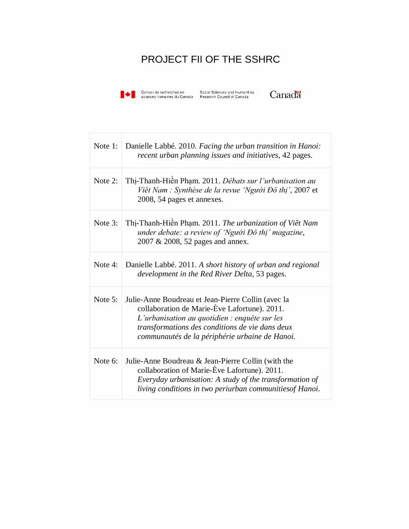
PROJECT FII OF THE SSHRC
Note 1:
Danielle Labbé. 2010. Facing the urban transition in Hanoi:
recent urban planning issues and initiatives, 42 pages.
Note 2:
Thị-Thanh-Hiền Phạm. 2011. Débats sur l’urbanisation au
Viêt Nam : Synthèse de la revue ‘Người Đô thị’, 2007 et
2008, 54 pages et annexes.
Note 3:
Thị-Thanh-Hiền Phạm. 2011. The urbanization of Viêt Nam
under debate: a review of ‘Người Đô thị’ magazine,
2007 & 2008, 52 pages and annex.
Note 4:
Danielle Labbé. 2011. A short history of urban and regional
development in the Red River Delta, 53 pages.
Note 5:
Julie-Anne Boudreau et Jean-Pierre Collin (avec la
collaboration de Marie-Ève Lafortune). 2011.
L’urbanisation au quotidien : enquête sur les
transformations des conditions de vie dans deux
communautés de la périphérie urbaine de Hanoi.
Note 6: Julie-Anne Boudreau & Jean-Pierre Collin (with the
collaboration of Marie-Ève Lafortune). 2011.
Everyday urbanisation: A study of the transformation of
living conditions in two periurban communitiesof Hanoi.

TABLE OF CONTENTS
LIST OF FIGURES ................................................................................................. VIII
FOREWORD ............................................................................................................ IX
AVANT-PROPOS ..................................................................................................... XI
INTRODUCTION ...................................................................................................... 13
1. HANOI PORTRAIT: HISTORY, TERRITORY, POPULATION, AND ECONOMY ........................................................................................................... 3
2. URBAN AND ARCHITECTURAL HERITAGE PROTECTION .............................. 9
3. PUBLIC SPACE UPGRADE AND PROVISION .................................................. 13
4. URBAN TRANSPORTATION: FROM PRIVATE MOTORBIKES TO RAPID MASS TRANSIT ................................................................................................. 17
5. HOUSING PROVISION ...................................................................................... 23
6. PERI-URBAN INTEGRATION ............................................................................ 29
7. CONCLUSION AND RESEARCH AVENUES ..................................................... 35
7.1 Integrating Rural and Urban Regional Planning ....................................................35
7.2 Updating Urban Management Mechanisms...........................................................36
7.3 Improving Urban Land Development Planning and Coordination ..........................36
7.4 Understanding and Dealing with Urban Poverty ....................................................37
7.5 Getting Ready to Face Climate Change ................................................................37
REFERENCES ......................................................................................................... 39
viii
List of Figures
Figure 2.1 Map of the Hanoi city-province................................................................................. 4
Figure 2.2 Map of pre-colonial Hanoi ........................................................................................ 5
Figure 2.3 Hanoi‟s opera house was built during the first decade of the 20th century. ............... 6
Figure 3.1 Traditional shophouse in the Old Quarter ................................................................. 9
Figure 3.2 Colonial villa .......................................................................................................... 10
Figure 4.1 The new Hang Trong Park offers very few recreational options to users. ................ 13
Figure 4.2 Multiple uses of sidewalk space compete with each other ...................................... 14
Figure 4.3 Sidewalk spaces are extensively used in the new urban areas of Hanoi. ................ 15
Figure 5.1 Hanoi‟s streets look like a continuous stream of motorcycles. ................................ 17
Figure 5.2 Traffic jams are increasingly common in Hanoi. ..................................................... 18
Figure 5.3 Passenger waiting for the bus in Hanoi .................................................................. 19
Figure 5.4 Artist‟s rendering of a light-rail transit station in Hanoi ............................................ 20
Figure 5.5 New buses interchange at the foot of the Long Bien Bridge.................................... 21
Figure 6.1 Houses produced by individual households in the 1990s........................................ 23
Figure 6.2 “The Manor,” a new urban area on the outskirts of Hanoi ....................................... 24
Figure 6.3 Bird‟s eye artist rendering of Splendora ................................................................. 26
Figure 7.1 A new high-rise building overlooks a traditional building in a peri-urban village under urbanization. ................................................................................................. 29
Figure 7.2 Typical peri-urban landscape juxtaposing aquaculture and new houses ................. 30
Figure 7.3 High-rise buildings in an NUA under construction on the western edge of Hanoi .... 31
Figure 7.4 A new golf course in the region of Hanoi. ............................................................... 33
.
Foreword
The urban transition is a central phenomenon in Viêt Nam, affecting all aspects of
social, cultural, economic and political life. For the next 25 years, Vietnamese cities are
expected to grow at an annual rate of 6%, with the result that the proportion of urban
population will increase from 30 to 50% (MoC, 2009). Such a rapid transition inevitably
produces significant changes in everyday life.
A number of researchers have focused their attention on understanding the urban
transition. Fieldwork is mainly carried out on the peripheral areas of large cities where a
dense mesh of villages are facing a process of accelerated in situ urbanization, both
spontaneous in nature and as an outcome of the central government’s policies on land
use conversions. As a result of this planning approach, the right to use land for
agricultural purposes is revoked by the government, concessions are granted to private
developers or ―privatized‖1 state corporations, and villagers are forced to abandon their
agricultural livelihood to enter retraining programs and join the service industry in
either the formal or informal sectors. Plagued to conflicts, this process has given rise to
bitter struggles over land compensation, to tensions between villagers and the newly
arrived urban population, and to conflicts between different jurisdictions whether local,
provincial or national. In addition to these conspicuous shifts, major changes stemming
from the economic reforms introduced in the country during the 1980s have contributed
significantly to the redefine the national economic structure, everyday life patterns of
consumption, and work and street-level behaviours.
This research brief is the result of a project conducted between 2007 and 2010 on An
Khánh and Tân Triều, two periurban incorporated towns" par "two periurban communes
recently incorporated in the urban administrative space of Hà Nội (―Urban Transition in
Viêt Nam: Issues and Prospects‖). The following questions were raised:
1. What are the strategies used by village inhabitants to address the social, cultural
and economic shifts spurred on by urbanization, in relation to the following
issues:
a. The labour market;
b. Patterns of consumption, in particular regarding the purchase of food;
1 Following the introduction of the Đổi mới reforms in the 1980s, the state has progressively privatized its public enterprises by registering them as a joint-stock company under the Private Enterprise Act, while retaining control of a majority of their shares.
x
c. The management of family conditions (gender relations, mobility
opportunities, etc.);
d. Conflict arbitration and relationships between newcomers and host
communities
2. Has the perception of residents towards the urban transition changed in any way
according to the way in which the central state framed urbanization?
3. Have these shifts led to the creation of civil society organisations? To what
extent do they take part in planning decisions?
4. How are populations and governments addressing environmental problems
arising from urbanization?
In close collaboration with our colleagues from the Sustainable Development Institute
for the North (SDIN) of the Vietnamese Academy of Social Sciences (VASS), this
research deals with the wider context of the ongoing discussion on urbanization in Viêt
Nam. Its importance can be seen through the urban development process for the 2050
Masterplan and the debates appearing in daily newspapers.
As the nation’s capital city and second largest agglomeration after Hồ Chí Minh City,
Hà Nội is one of the key sites of Viêt Nam’s urban transition. The focus of this report is
on the mechanisms by which local populations and authorities of Hà Nội attempt to
ensure the sustainable growth and development of the city’s territory, society, and
space. While many problems remain unaddressed, recent years witnessed the emergence
of planning initiatives that aim to mitigate the negative impacts of urbanization. The
first section provides a contextual background on Hà Nội, sketching a portrait of its
history, territory, population, and economy. Illustrated with case studies, the subsequent
sections describe planning issues and initiatives taken in five areas: heritage
preservation, public space, transportation, housing production, and periurban
integration. Existing conditions in each of the areas along with the mechanisms
proposed by planning authorities and other stakeholders to cope with emerging issues
are presented. The report concludes by identifying areas in need of further research.
We wish to thank Cathleen Poehler for her editorial assistance and Cindy Rojas for
layout. This research was funded by the International Opportunities Fund of the Social
Sciences and Humanities Research Council of Canada, the ministère des Relations
internationales du Québec and the INRS Urbanisation, Culture et Société research centre.
Julie-Anne Boudreau and Jean-Pierre Collin
Avant-Propos
La transition urbaine est un phénomène majeur au Viêt Nam, touchant tous les aspects
de la vie sociale, culturelle, économique et politique. Pour les prochaines 25 années, on
projette une croissance des villes vietnamiennes de 6% par année, ce qui propulsera le
taux d’urbanisation du pays de 30 à 50% (MoC, 2009). Il va sans dire qu’une transition
si rapide produit des bouleversements importants de la vie quotidienne.
Plusieurs chercheurs se penchent sur la transition urbaine. Beaucoup de travaux
explorent plus particulièrement les périphéries des grandes villes dans lesquelles un
maillage dense de villages s’urbanise in situ, tant spontanément que suite à la
conversion de l’usage des sols planifiée par le gouvernement central. Sur le terrain, cette
planification se traduit par une révocation des terres agricoles par le gouvernement, leur
développement par des promoteurs privés ou par les sociétés d’État « privatisées »2 et la
reconversion forcée pour les villageois d’un mode de subsistance agricole à l’intégration
du secteur tertiaire officiel ou non. Il s’agit d’un processus fort conflictuel avec des
frictions importantes autour des compensations pour les terres, des relations entre les
villageois et les nouveaux habitants des zones urbanisées, et des relations entre les
autorités locales, provinciales et centrales. À ces transformations palpables sur le terrain
s’ajoutent les bouleversements majeurs résultant de l’ouverture économique du pays
dans les années 1980, ce qui reconfigure autant la structure économique nationale que
les comportements quotidiens de consommation, de travail, d’échanges dans les rues.
Cette note de recherche est issue d’un projet mené entre 2007 et 2010 dans deux
communes périurbaines de Hà Nội, An Khánh et Tân Triều (« Urban Transition in Viêt
Nam : Issues and Prospects »). Nous nous posions les questions suivantes :
1. Quelles stratégies développent les habitants de ces villages pour répondre aux
transformations sociales, culturelles et économiques apportées par
l’urbanisation, en regard :
a. du marché de la main-d’oeuvre;
b. des comportements de consommation –notamment au chapitre de
l’alimentation;
c. des conditions de vie familiale (rapports de genre, mobilité, etc.);
d. des conflits de médiation et des relations entre les nouveaux venus et les
communautés d’accueil ?
2 Suite aux réformes du Đổi mới qui ont débuté dans les années 1980, l’État a graduellement privatisé ses entreprises en les
enregistrant comme compagnie par action sous la Loi des entreprises privées mais en gardant souvent le contrôle sur la majorité
des parts.
xii
2. Est-ce que l’évolution de l’attitude étatique face à l’urbanisation a influencé la
perception des habitants face à la transition urbaine?
3. Y-a-t-il eu de nouvelles organisations de la société civile créées dans la foulée de
ces transformations? Celle-ci ont-elle un poids dans les décisions de
planification?
4. Comment les populations et les autorités font-ils face aux problèmes
environnementaux engendrés par l’urbanisation?
Menée conjointement avec nos collègues de l’Institut pour le développement durable du
nord (Institute for the sustainable development of the North, ISDN) de l’Académie des
sciences sociales du Viêt Nam (Vietnamese Academy of Social Sciences, VASS), cette
recherche s’inscrit donc dans un débat animé au Viêt Nam sur l’urbanisation, comme en
témoignent le processus d’élaboration du nouveau plan d’urbanisation à l’horizon 2050
et les débats quotidiens dans les journaux.
Au double titre de capitale et de deuxième plus importante agglomération urbaine après
Hồ Chí Minh Ville, Hà Nội est l’un des sites majeurs de la transition urbaine que connaît
présentement le Viêt Nam. La présente note de recherche porte sur les mécanismes par
lesquelles, les citoyens et les autorités de Hà Nội gèrent la croissance et le développement
durable de la ville, de la société et des espaces de l’agglomération. Bien que plusieurs
problèmes soient toujours en attente de réponses adéquates, les dernières années
témoignent de l’émergence d’initiatives de planification propres à atténuer les impacts
négatifs de l’urbanisation. La première section offre un tour d’horizon du contexte de Hà
Nội en esquissant un portrait général de son histoire, son territoire, sa population et son
économie. Prenant appui sur des études de cas, les sections suivantes décrivent les
problèmes et les initiatives qui ont marqué cinq domaines de la planification urbaine : la
préservation du patrimoine, les espaces publics, le transport, la production résidentielle et
l’intégration des zones périrubaines. Chaque fois, sont présentés les conditions existantes
et les mécanismes proposés par les agences publiques de planification et d’autres acteurs
pour répondre aux enjeux émergents. L’analyse se termine sur une proposition quant aux
thèmes devant faire l’objet de nouvelles recherches.
Nous tenons à remercier Cathleen Poehler pour la révision du texte et Cindy Rojas pour
sa mise en page. Ce travail a été financé par le Fond d’initiatives internationales du
Conseil de recherches en sciences humaines du Canada, par le Ministère des relations
internationales du Québec et par le centre Urbanisation Culture Société de l’INRS.
Julie-Anne Boudreau et Jean-Pierre Collin
Introduction
Vietnam is currently experiencing one of the most intensive urban transitions in the
world. Over the next 25 years, its cities and towns are expected to grow at an average
rate of 6% per year, increasing the national share of Vietnam’s urban population from
one-third to one-half (MoC 2009). This shift from a rural to an urban society is closely
associated with socio-economic reforms instituted in the 1980s that progressively
liberalized the economy and relaxed the grip of the state on population movements and
activities. These reforms fostered a swift transition to an urban society through
combined processes of rural-urban migration, occupational shifts away from agriculture,
the physical expansion of existing urban areas, and the creation of new cities and towns
in densely-settled rural communes.
As the nation’s capital city and second largest agglomeration after Ho Chi Minh City,
Hanoi is one of the key sites of this urban transition. Vietnamese political leaders
acknowledge the fact that the growth of Hanoi and other cities is crucial to the shift
from agriculture to manufacturing and higher order services as well as to improve the
material well-being of the national population. At the same time, the rapid growth of
populations and activities in and around cities puts intense pressure on local authorities
to keep pace with rising demands for infrastructure, social services, housing,
environmental controls, and public amenities. Therefore, while there is consensus on the
potential benefits of urbanization, concerns are also raised by local and foreign
academics, professionals, and decision-makers about the importance of anticipating and
addressing problems ensuing from the urbanization process.
The mechanisms by which the people and authorities of Hanoi plan to ensure the
sustainable growth and development of the city’s territory, society, and space are still
very much in the making. While many problems remain to be addressed, recent years
have seen the emergence of urban development initiatives that aim to mitigate the
negative impacts of urbanization. These are the focus of this report. This survey is
organized as follows: The first section provides a contextual background on Hanoi,
sketching a portrait of its history, territory, population, and economy. The subsequent
sections describe problems and initiatives taken in five urban planning areas: heritage
preservation, public space, transportation, housing production, and peri-urban
integration. Existing conditions in each of the areas along with the mechanisms
proposed by planning authorities and other stakeholders to cope with emerging issues
are presented. The topics of each section are illustrated with case studies. The report
concludes by identifying areas in need of further research.

1. HANOI PORTRAIT: HISTORY, TERRITORY, POPULATION, AND
ECONOMY
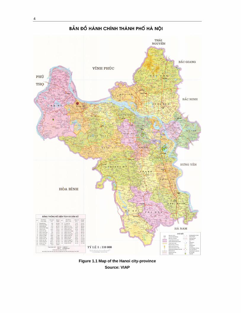
Hanoi is situated in the centre of Vietnam’s Red River delta. The city-province is
bordered by the provinces of Thai Nguyen to the north, Bac Ninh and Hung Yen to the
east, Vinh Phuc to the south, and Phu Tho and Hoa Binh to the west (see Fig. 2.1). Most
of Hanoi’s area lies within the low floodplain of the Red River, historically a site of
intensive wet rice agriculture. The remaining area is part of Soc Son District (to the
north), which is somewhat mountainous and hilly.
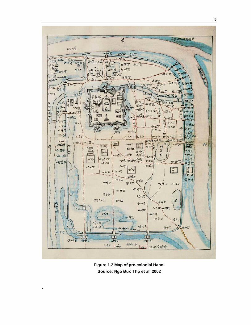
While Hanoi has been occupied by human populations for more than 2,000 years, the
city’s origins officially date back to 1010, when the emperor Ly Thai To built a citadel
and established the capital of his empire on the right bank of the Red River.
Progressively, a small trade area developed next to the imperial city that is now referred
to as the ―Old Quarter‖ (see Fig. 2.2). Throughout the following eight centuries, the city
developed slowly due to state control of trade and a succession of tumultuous wars
between competing dynasties. By the time the French settled in the city, in 1874, Hanoi
was a relatively small agglomeration of less than 100,000 people. Socio-spatially, it
consisted of a combination of three distinct spaces: a citadel, a merchant quarter, and an
agglomeration of rural villages surrounded by a dike (Logan 2000; Papin 2001).
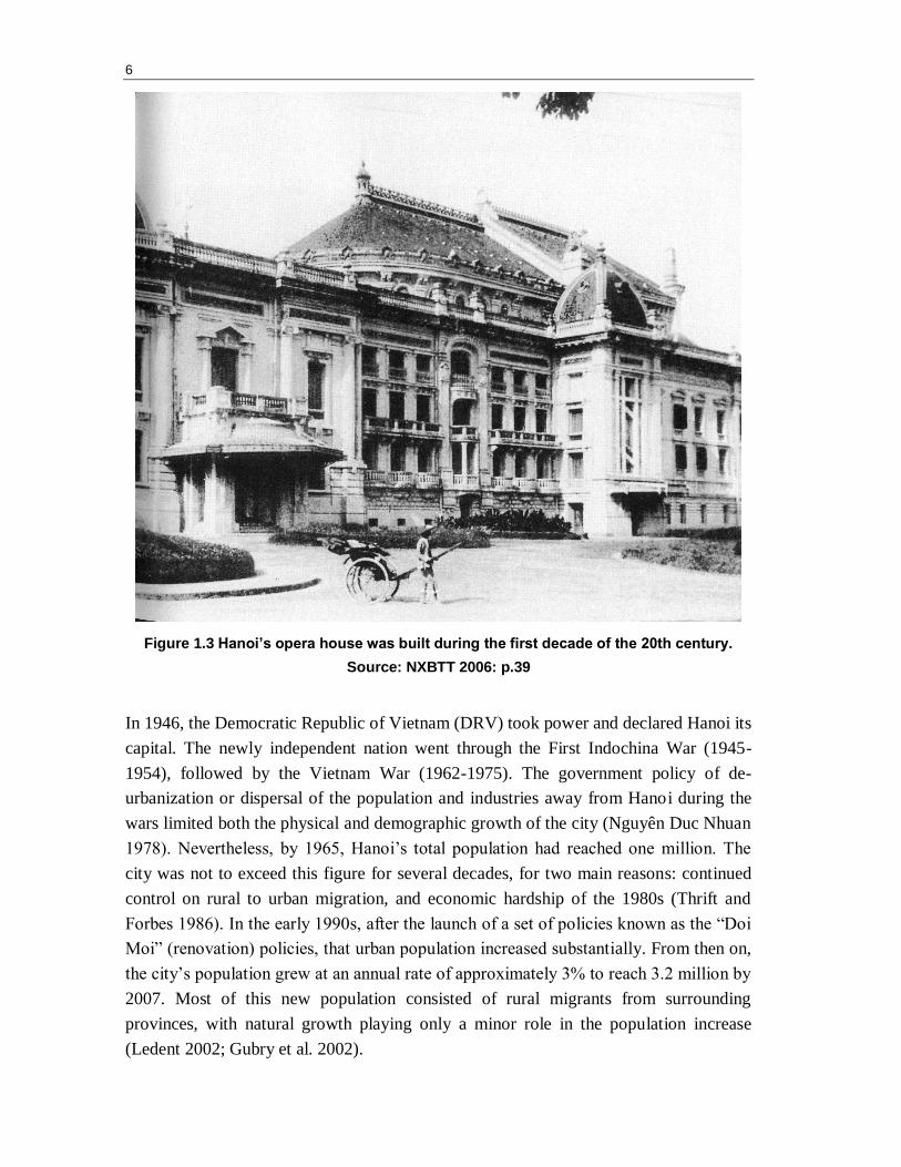
Hanoi was the capital of French Indochina from 1902 to 1953, during which time it
remained a modest city both in size and population, never exceeding 400,000
inhabitants (Wright 1991). Yet French planners greatly transformed the appearance and
functioning of the city. Up to the end of the 19th
century, colonial authorities expanded
the city area toward the south and west. There, they developed a new area with broad
avenues which, organized in a grid system and flanked by spacious villas and gardens,
is now referred to as the ―Colonial Quarter.‖ The French also developed major
infrastructures and facilities, including the Long Bien Bridge, a railway and train
station, a post office, and an opera house (see Fig. 2.3).
4
Figure 1.1 Map of the Hanoi city-province
Source: VIAP
5
Figure 1.2 Map of pre-colonial Hanoi
Source: Ngô Đưc Thọ et al. 2002
.
6
Figure 1.3 Hanoi’s opera house was built during the first decade of the 20th century.
Source: NXBTT 2006: p.39
In 1946, the Democratic Republic of Vietnam (DRV) took power and declared Hanoi its
capital. The newly independent nation went through the First Indochina War (1945-
1954), followed by the Vietnam War (1962-1975). The government policy of de-
urbanization or dispersal of the population and industries away from Hanoi during the
wars limited both the physical and demographic growth of the city (Nguyên Duc Nhuan
1978). Nevertheless, by 1965, Hanoi’s total population had reached one million. The
city was not to exceed this figure for several decades, for two main reasons: continued
control on rural to urban migration, and economic hardship of the 1980s (Thrift and
Forbes 1986). In the early 1990s, after the launch of a set of policies known as the ―Doi
Moi‖ (renovation) policies, that urban population increased substantially. From then on,
the city’s population grew at an annual rate of approximately 3% to reach 3.2 million by
2007. Most of this new population consisted of rural migrants from surrounding
provinces, with natural growth playing only a minor role in the population increase
(Ledent 2002; Gubry et al. 2002).
7
Hanoi’s administrative boundaries were redrawn several times throughout the 20th
century. Among the major changes was the large territorial expansion of the province in
1978 to encompass over 3,000 km2 (Rossi and Pham Van Cu 2002: 314-17). The
boundaries of the province were then redrawn in 1991 around a smaller territory of 900
km2. Thereafter, most of the administrative territorial changes consisted of attributing an
urban status to parts of rural districts peripheral to the city (Quertamp 2003: 86-93).
In 2008, the administrative boundaries of Hanoi were once again extended to include
the neighbouring province of Ha Tay as well as a handful of districts and communes
that formerly belonged to the provinces of Vinh Phuc and Hoa Binh. Upon completion
of this project, the territory of the capital reached 3,300 km² (3.6 times the size of the
previous area). In doing so, Hanoi absorbed wide areas of agricultural land that now
constitute two-thirds of its territory. This expansion also implied a doubling of the
official population of the capital city, namely, from 3.2 to 6.4 million inhabitants. A
large part of this new population is classified as ―rural‖ (3.7 million people, against 2.5
million classified as ―urban‖) (HSO 2009). In terms of population, Hanoi still comes
just after HCMC (6.8 million) but the city is now far ahead of Hai Phong (1.8 million)
and Da Nang (822,000). Although encompassing less densely settled areas, Hanoi’s
population density has now reached an average of 1,926 persons per km2 (HSO 2009).
The official objectives of the expansion were manifold. The enlargement served to
reaffirm the status of the capital city of Vietnam both at the national and regional scale.
The so-called ―New Hanoi‖ is expected to become a centre of politics, education,
science, economics, and international exchanges. The new territory is expected to
contribute to the economic and functional development of the city by encouraging
investment, including official development aid (ODA) and foreign direct investment
(FDI), and by allowing the expansion and modernization of the region’s infrastructure
network. The new territory is also expected to help accommodate the city’s
demographic growth and distribute the population outside of the overcrowded urban
core (VET 2008). The exact intentions for the future of the New Hanoi will be revealed
with the release of the Master Plan for 2030 and Vision for 2050. These two documents
have been in preparation since 2009 by a consortium of three planning and architectural
firms from South Korea (JICA and Posco) and the United States (Perkins Eastman)
working in collaboration with the Vietnam Institute of Architecture and Planning
(VIAP).
8
Hanoi’s economy is growing steadily. The city’s GDP expanded three-fold between
2000 and 20083 (HSO 2009: 65). While Hanoi is only home to 7% of Vietnam’s
population, it contributes 12.5% of the national GDP.4 Although the city-province
encompasses a significant area of agricultural hinterland, the contribution of the primary
sector to Hanoi's GDP is rather low. Hanoi’s gross output of industry is also relatively
low, representing only 13% of the country’s total output (compared to 25% for HCMC)
in 2008. Hanoi is indeed a less industrialized region than HCMC. As can be expected
from a capital city, the proportion of the population working in the government sector is
relatively high, representing 9% of the province’s workforce (compared to 6% in
HCMC and 2% in Hai Phong) (HSO 2009). A growing part of Hanoi’s economic
growth also comes from FDI. In 2008, Hanoi received close to US$18.8 billion in FDI,
accounting for 7% of the total investment in Vietnam (HSO 2009: 222).
The current intentions of the national and municipal authorities are geared to develop a
knowledge-based urban economy. This is manifest in the decision to build a large high-
technology satellite city 30 kilometres west of the city. Upon completion, the so-called
―Lang Hoa-Lac Hi-tech City‖ will accommodate major universities and high-quality
industrial production and human resources (Nguyen Thai Huyen 2009). The creation of
this ―high-tech city‖ is part of a larger regional development approach that fosters the
creation of a multi-polar urban region consisting of autonomous satellite cities dispersed
around the existing agglomeration.
3 Based on current prices. However, this period also saw an important rise in inflation.
4 While substantial, this contribution is only half of that of Ho Chi Minh City.
2. URBAN AND ARCHITECTURAL HERITAGE PROTECTION
The protection of architectural heritage in central Hanoi has a long history. The roots of
this movement can be traced back to the beginning of the 20th century when the French
started to identify and catalogue remarkable monuments on the Indochinese peninsula
(Nishimura 1997). While concerns for the built heritage faded during wartimes and
throughout the subsidy era5, it revived again in the early 1990s. Following the re-
opening of Vietnam’s borders to foreign visitors, Hanoi revealed to the rest of the world
one of the best preserved cities of Southeast Asia.
The city’s architectural and urban heritage combines exceptional monuments and
compounds such as pagodas, temples, the citadel, and government buildings scattered
through the urban fabric. Hanoi also displays exceptional urban ensembles. The core of
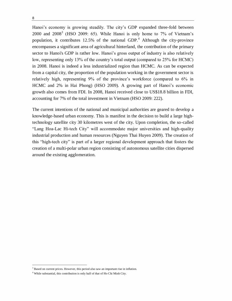
the city consists of a traditional merchant quarter dating back to feudal times. This area
is characterized by an organic network of narrow streets lined with traditional
shophouses (see Fig. 3.1) (Pham Dinh Viêt 1997).
Figure 2.1 Traditional shophouse in the Old Quarter
Source: D. Labbé, 2004
5 Vietnamese use the expression ―thoi bao cap‖—literally translated as ―subsidy era‖—to refer to the period stretching from 1954 to
1986 during which the state subsidized a large part of socio-economic activities.
10
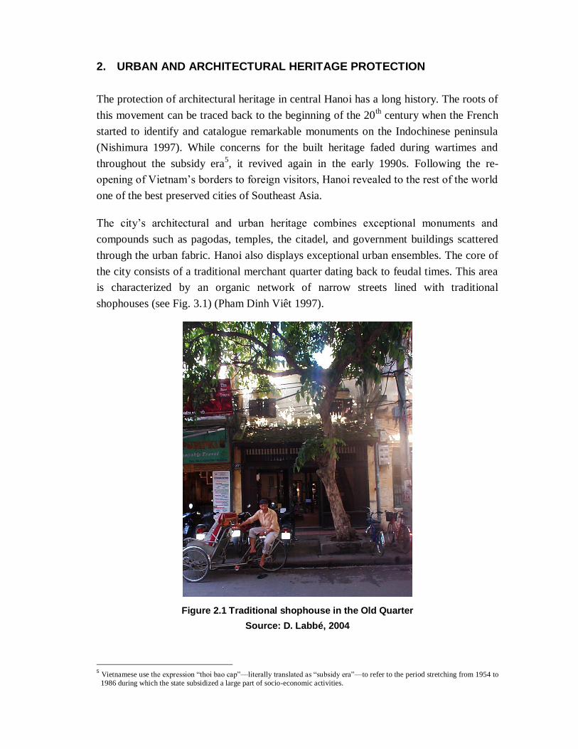
South of the Old Quarter is the Colonial Quarter, an area planned under the French that
functioned as the administrative and commercial centre of Indochina. As mentioned,
this area is characterized by a regular street grid of broad avenues, lined with trees and
flanked by luxurious villas (see Fig. 3.2). Hanoi’s urban fabric further includes a myriad
of erstwhile rural villages now engulfed into the urban fabric. The city is also
characterized by a unique natural environment with numerous rivers and lakes, tree-
lined streets, and parks.
Figure 2.2 Colonial villa
Source: D. Labbé, 2005
This built and natural heritage experienced considerable transformations over time,
either due to war destruction, poor maintenance during less affluent periods,
transformations by users due to changes in needs and tastes, and demolition to make
way for larger and more profitable buildings (UNCHS 2002: 4-42). According to many
experts, Hanoi’s built heritage is at risk of disappearing if nothing is done to curb
degradation, inappropriate renovations, and rapid demolitions (Logan 1994; Maclaren
1996; Parenteau and Champagne 1994; Nguyên Quang and Kammeir 1997; Terunobu et
al. 1997). Throughout the 1990s and 2000s, this prognosis catalyzed an onslaught of
preservation-oriented development projects. During this period, more than twenty
development projects, funded by ten different organizations, addressed the issue of
preserving the built heritage of the Old Quarter and the Colonial Quarter.
11
These preservation projects set out with a relatively narrow focus on architectural
preservation but progressively embraced wider concerns about tradition, including the
preservation of immaterial heritages such as traditional economic activities and
lifestyles. Nevertheless, on the whole these heritage preservation projects tended to
focus on a small number of symbolic monuments and on the preservation of the Old
Quarter and the Colonial Quarter to the detriment of other components of Hanoi’s built
and natural landscape. Hence, many of the lakes that once characterized the city have
been filled. The rivers and canals that were once a part of what gave the city a unique
character are also being progressively buried underground (a decision often justified by
high pollution levels) (Shibayama et al. 2008). At the same time, the former villages
that are being integrated into the city space are also witnessing the disappearance of
their ancient gates, central ponds, ancient houses, and other cultural and architectural
landmarks.
Box 3.1: Thang Long Imperial Citadel
In June 2006, the government of Vietnam submitted an application to the UNESCO for the classification of the Thang Long Imperial Citadel complex as a World
Heritage site. The citadel is a highly significant place in Vietnam’s national history.
The complex covers approximately 50 hectares. It corresponds to the areas of the Forbidden City and Imperial Citadel which were first built during pre-colonial
times. While most of the original buildings were destroyed during wars, many relics
remain underground that have been unearthed by archaeologists, including many
architectural vestiges and artefacts from the period during which Vietnam was under Chinese domination and from more recent dynasties. All over the site,
cultural layers appear and are testimonies of continual cultural and physical changes
during a period of over 13 centuries. The Vietnamese authorities are hoping to get the Thang Long Imperial Citadel listed as one of the UNESCO World Heritage site
in time for the millennial of Hanoi, in 2010.
Sources: http://whc.unesco.org/

3. PUBLIC SPACE UPGRADE AND PROVISION
Hanoi is recognized as one of the most overcrowded cities in the world. In 2008, human
densities in the urban districts reached an average of 272 persons per hectare and up to
404 persons per hectare in the historic core (compared to 370 persons per hectare in
Hong Kong, 86 in Paris, and 62 in London) (ABD 2006). Such human densities put
enormous pressure on the city to provide common spaces for people to engage in social
interactions, exercise, get away from the traffic and pollution, and enjoy environments
other than the exceptionally cramped quarters of their homes (UNCHS 2002).
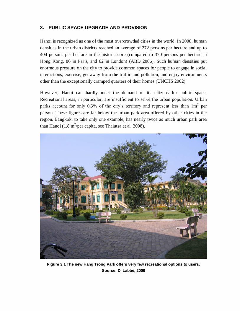
However, Hanoi can hardly meet the demand of its citizens for public space.
Recreational areas, in particular, are insufficient to serve the urban population. Urban
parks account for only 0.3% of the city’s territory and represent less than 1m2 per
person. These figures are far below the urban park area offered by other cities in the
region. Bangkok, to take only one example, has nearly twice as much urban park area
than Hanoi (1.8 m2/per capita, see Thaiutsa et al. 2008).
Figure 3.1 The new Hang Trong Park offers very few recreational options to users.
Source: D. Labbé, 2009
14
Existing parks are unevenly distributed across the city. They concentrate in the urban
core with approximately 1.5 m2 of park space per capita in the four central districts,
while the urban peripheral districts offer only 0.05 m2 of park space per capita. The
parks in Hanoi lack accessibility, in particular for young people and the elderly. About
half of Hanoi’s residents do not have a park within walking distance or with easy access
from their house (HAIDEP 2005). Moreover, existing public spaces, even large ones
such as Reunification Park, often offer few recreational options to users. Instead, urban
public spaces in Hanoi are generally designed with an emphasis on ornamental
flowerbeds and geometrically patterned alleyways. Such areas can hardly meet the
population’s growing demand for spaces that foster socializing and participation in
recreational activities (see Fig. 4.1).
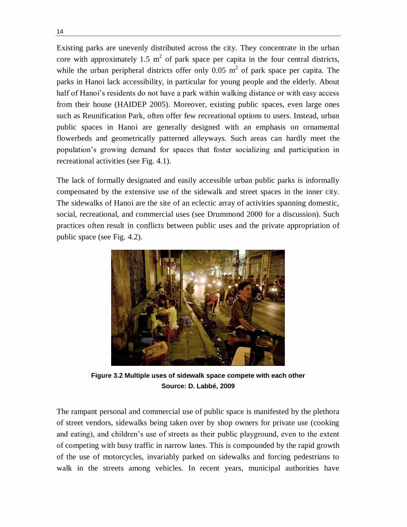
The lack of formally designated and easily accessible urban public parks is informally
compensated by the extensive use of the sidewalk and street spaces in the inner city.
The sidewalks of Hanoi are the site of an eclectic array of activities spanning domestic,
social, recreational, and commercial uses (see Drummond 2000 for a discussion). Such
practices often result in conflicts between public uses and the private appropriation of
public space (see Fig. 4.2).
Figure 3.2 Multiple uses of sidewalk space compete with each other
Source: D. Labbé, 2009
The rampant personal and commercial use of public space is manifested by the plethora
of street vendors, sidewalks being taken over by shop owners for private use (cooking
and eating), and children’s use of streets as their public playground, even to the extent
of competing with busy traffic in narrow lanes. This is compounded by the rapid growth
of the use of motorcycles, invariably parked on sidewalks and forcing pedestrians to
walk in the streets among vehicles. In recent years, municipal authorities have
15
attempted to regulate sidewalk use more strictly, prohibiting mobile vending and
controlling some of the private appropriation of public space by shop owners (Kurfürst
2009; Koh 2008). Yet, even the most regulated sidewalks of Hanoi cannot replace safe
and accessible public parks where residents can get away from traffic and air pollution,
enjoy larger playgrounds, and make use of quality community meeting spaces.
Figure 3.3 Sidewalk spaces are extensively used in the new urban areas of Hanoi.
Source: D. Labbé, 2009
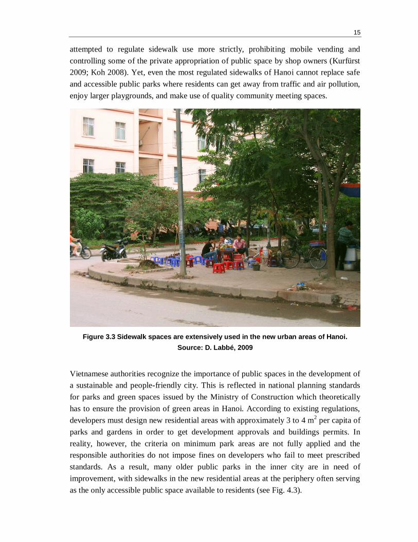
Vietnamese authorities recognize the importance of public spaces in the development of
a sustainable and people-friendly city. This is reflected in national planning standards
for parks and green spaces issued by the Ministry of Construction which theoretically
has to ensure the provision of green areas in Hanoi. According to existing regulations,
developers must design new residential areas with approximately 3 to 4 m2 per capita of
parks and gardens in order to get development approvals and buildings permits. In
reality, however, the criteria on minimum park areas are not fully applied and the
responsible authorities do not impose fines on developers who fail to meet prescribed
standards. As a result, many older public parks in the inner city are in need of
improvement, with sidewalks in the new residential areas at the periphery often serving
as the only accessible public space available to residents (see Fig. 4.3).
16
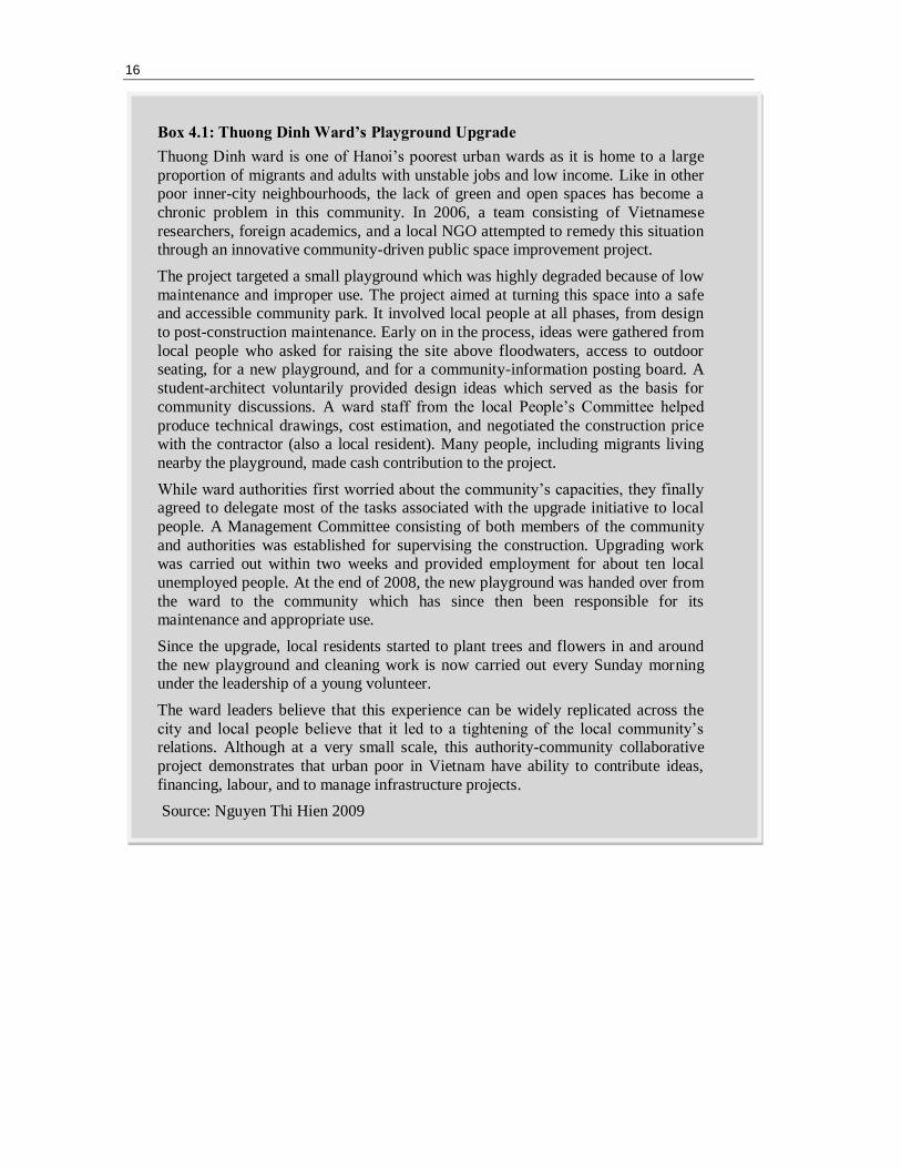
Box 4.1: Thuong Dinh Ward’s Playground Upgrade
Thuong Dinh ward is one of Hanoi’s poorest urban wards as it is home to a large
proportion of migrants and adults with unstable jobs and low income. Like in other poor inner-city neighbourhoods, the lack of green and open spaces has become a
chronic problem in this community. In 2006, a team consisting of Vietnamese
researchers, foreign academics, and a local NGO attempted to remedy this situation through an innovative community-driven public space improvement project.
The project targeted a small playground which was highly degraded because of low
maintenance and improper use. The project aimed at turning this space into a safe and accessible community park. It involved local people at all phases, from design
to post-construction maintenance. Early on in the process, ideas were gathered from
local people who asked for raising the site above floodwaters, access to outdoor seating, for a new playground, and for a community-information posting board. A
student-architect voluntarily provided design ideas which served as the basis for
community discussions. A ward staff from the local People’s Committee helped
produce technical drawings, cost estimation, and negotiated the construction price with the contractor (also a local resident). Many people, including migrants living
nearby the playground, made cash contribution to the project.
While ward authorities first worried about the community’s capacities, they finally agreed to delegate most of the tasks associated with the upgrade initiative to local
people. A Management Committee consisting of both members of the community
and authorities was established for supervising the construction. Upgrading work was carried out within two weeks and provided employment for about ten local
unemployed people. At the end of 2008, the new playground was handed over from
the ward to the community which has since then been responsible for its maintenance and appropriate use.
Since the upgrade, local residents started to plant trees and flowers in and around
the new playground and cleaning work is now carried out every Sunday morning under the leadership of a young volunteer.
The ward leaders believe that this experience can be widely replicated across the
city and local people believe that it led to a tightening of the local community’s relations. Although at a very small scale, this authority-community collaborative
project demonstrates that urban poor in Vietnam have ability to contribute ideas,
financing, labour, and to manage infrastructure projects.
Source: Nguyen Thi Hien 2009
4. URBAN TRANSPORTATION: FROM PRIVATE MOTORBIKES TO RAPID
MASS TRANSIT
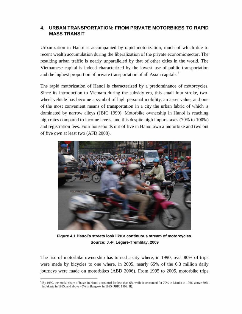
Urbanization in Hanoi is accompanied by rapid motorization, much of which due to
recent wealth accumulation during the liberalization of the private economic sector. The
resulting urban traffic is nearly unparalleled by that of other cities in the world. The
Vietnamese capital is indeed characterized by the lowest use of public transportation
and the highest proportion of private transportation of all Asian capitals.6
The rapid motorization of Hanoi is characterized by a predominance of motorcycles.
Since its introduction to Vietnam during the subsidy era, this small four-stroke, two-
wheel vehicle has become a symbol of high personal mobility, an asset value, and one
of the most convenient means of transportation in a city the urban fabric of which is
dominated by narrow alleys (JBIC 1999). Motorbike ownership in Hanoi is reaching
high rates compared to income levels, and this despite high import-taxes (70% to 100%)
and registration fees. Four households out of five in Hanoi own a motorbike and two out
of five own at least two (AFD 2008).
Figure 4.1 Hanoi’s streets look like a continuous stream of motorcycles.
Source: J.-F. Légaré-Tremblay, 2009
The rise of motorbike ownership has turned a city where, in 1990, over 80% of trips
were made by bicycles to one where, in 2005, nearly 65% of the 6.3 million daily
journeys were made on motorbikes (ABD 2006). From 1995 to 2005, motorbike trips
6 By 1999, the modal share of buses in Hanoi accounted for less than 6% while it accounted for 70% in Manila in 1996, above 50%
in Jakarta in 1985, and above 45% in Bangkok in 1995 (JBIC 1999: II).
18
have multiplied by six. The constant increase in motorcycle ownership is now also
becoming paralleled by a growing number of cars. In 2005, only 2% of households in
Hanoi owned cars, representing less than 4% of the city’s modal share. But between
2004 and 2007, new vehicle registrations in Hanoi increased at a two-digit rate,
reaching 20% over the last two years (Hieu Nguyen Ngoc 2009). In the meantime, the
number of non-motorized vehicles—especially bicycles—on the streets of Hanoi is
plummeting (see Fig. 5.1 and Fig. 5.2).
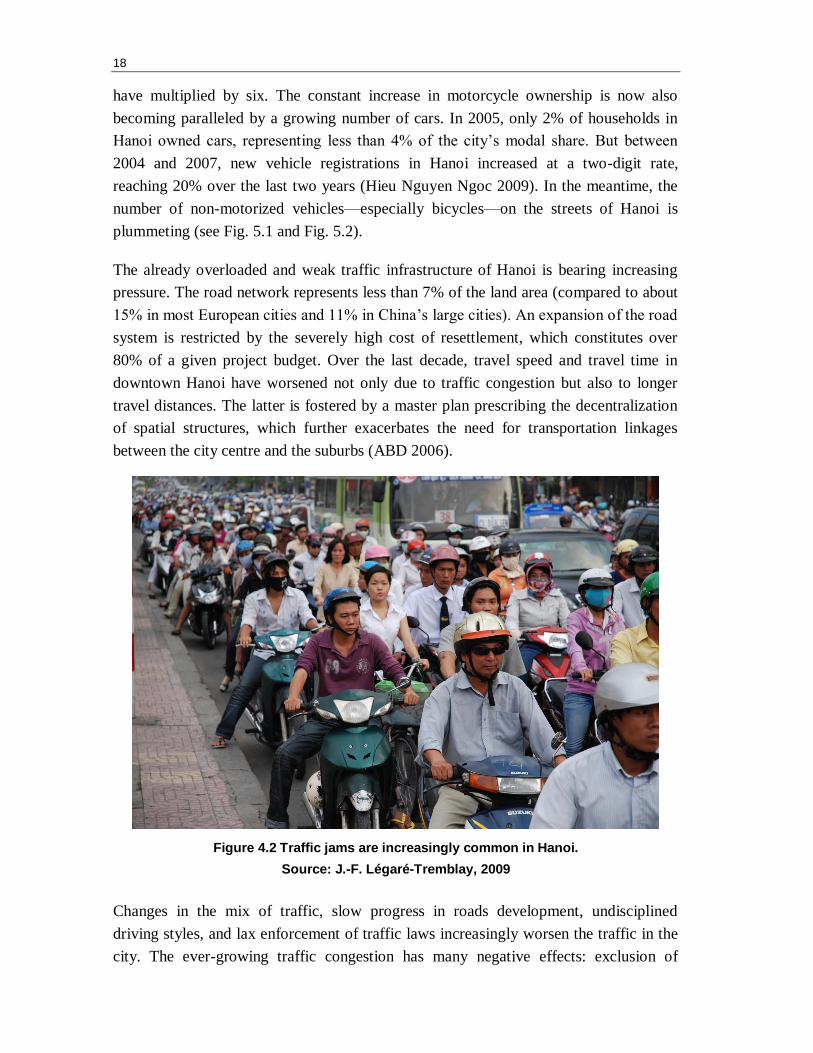
The already overloaded and weak traffic infrastructure of Hanoi is bearing increasing
pressure. The road network represents less than 7% of the land area (compared to about
15% in most European cities and 11% in China’s large cities). An expansion of the road
system is restricted by the severely high cost of resettlement, which constitutes over
80% of a given project budget. Over the last decade, travel speed and travel time in
downtown Hanoi have worsened not only due to traffic congestion but also to longer
travel distances. The latter is fostered by a master plan prescribing the decentralization
of spatial structures, which further exacerbates the need for transportation linkages
between the city centre and the suburbs (ABD 2006).
Figure 4.2 Traffic jams are increasingly common in Hanoi.
Source: J.-F. Légaré-Tremblay, 2009
Changes in the mix of traffic, slow progress in roads development, undisciplined
driving styles, and lax enforcement of traffic laws increasingly worsen the traffic in the
city. The ever-growing traffic congestion has many negative effects: exclusion of
19
vulnerable populations (children, the elderly or disabled, poor populations without
vehicles, etc.), rise in transport costs, urban productivity declines, as well as increasing
greenhouse gas emissions, air pollution, noise, and accidents (ISTED 2006).
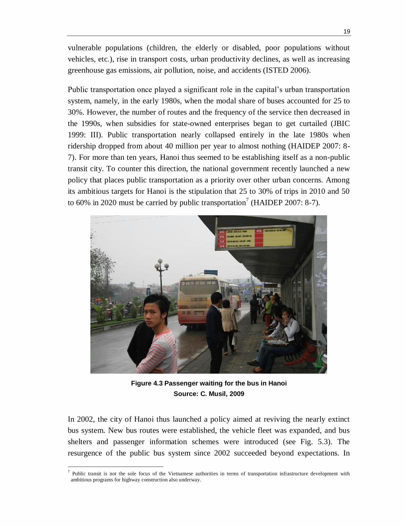
Public transportation once played a significant role in the capital’s urban transportation
system, namely, in the early 1980s, when the modal share of buses accounted for 25 to
30%. However, the number of routes and the frequency of the service then decreased in
the 1990s, when subsidies for state-owned enterprises began to get curtailed (JBIC
1999: III). Public transportation nearly collapsed entirely in the late 1980s when
ridership dropped from about 40 million per year to almost nothing (HAIDEP 2007: 8-
7). For more than ten years, Hanoi thus seemed to be establishing itself as a non-public
transit city. To counter this direction, the national government recently launched a new
policy that places public transportation as a priority over other urban concerns. Among
its ambitious targets for Hanoi is the stipulation that 25 to 30% of trips in 2010 and 50
to 60% in 2020 must be carried by public transportation7 (HAIDEP 2007: 8-7).
Figure 4.3 Passenger waiting for the bus in Hanoi
Source: C. Musil, 2009
In 2002, the city of Hanoi thus launched a policy aimed at reviving the nearly extinct
bus system. New bus routes were established, the vehicle fleet was expanded, and bus
shelters and passenger information schemes were introduced (see Fig. 5.3). The
resurgence of the public bus system since 2002 succeeded beyond expectations. In
7 Public transit is not the sole focus of the Vietnamese authorities in terms of transportation infrastructure development with
ambitious programs for highway construction also underway.
20
2003, ridership was more than three times as high as during the peak year of the 1980s
(HAIDEP 2007). Yet, despite a spectacular 20-fold increase in bus ridership from 1.2
million monthly trips in 2001 to over 24 million monthly trips in 2006, public transport
still only accounts for only 10% of total trips (ABD 2006).
In light of the fact that the above-mentioned traffic congestion limits the attractiveness
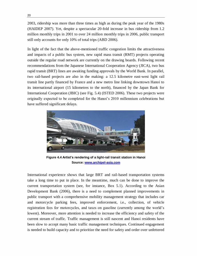
and impacts of a public bus system, new rapid mass transit (RMT) projects operating
outside the regular road network are currently on the drawing boards. Following recent
recommendations from the Japanese International Cooperation Agency (JICA), two bus
rapid transit (BRT) lines are awaiting funding approvals by the World Bank. In parallel,
two rail-based projects are also in the making: a 12.5 kilometre east-west light rail
transit line partly financed by France and a new metro line linking downtown Hanoi to
its international airport (15 kilometres to the north), financed by the Japan Bank for
International Cooperation (JBIC) (see Fig. 5.4) (ISTED 2006). These two projects were
originally expected to be completed for the Hanoi’s 2010 millennium celebrations but
have suffered significant delays.
Figure 4.4 Artist’s rendering of a light-rail transit station in Hanoi
Source: www.archipel-asia.com
International experience shows that large BRT and rail-based transportation systems
take a long time to put in place. In the meantime, much can be done to improve the
current transportation system (see, for instance, Box 5.1). According to the Asian
Development Bank (2006), there is a need to complement planned improvements in
public transport with a comprehensive mobility management strategy that includes car
and motorcycle parking fees, improved enforcement, i.e., collection, of vehicle
registration fees for motorcycles, and taxes on gasoline (currently among the world’s
lowest). Moreover, more attention is needed to increase the efficiency and safety of the
current stream of traffic. Traffic management is still nascent and Hanoi residents have
been slow to accept many basic traffic management techniques. Continued engagement
is needed to build capacity and to prioritize the need for safety and order over unfettered
21
mobility. There is also a need to enhance the capacities of the institutions responsible
for land-use development, and to integrate their missions with other transport and
infrastructure plans.
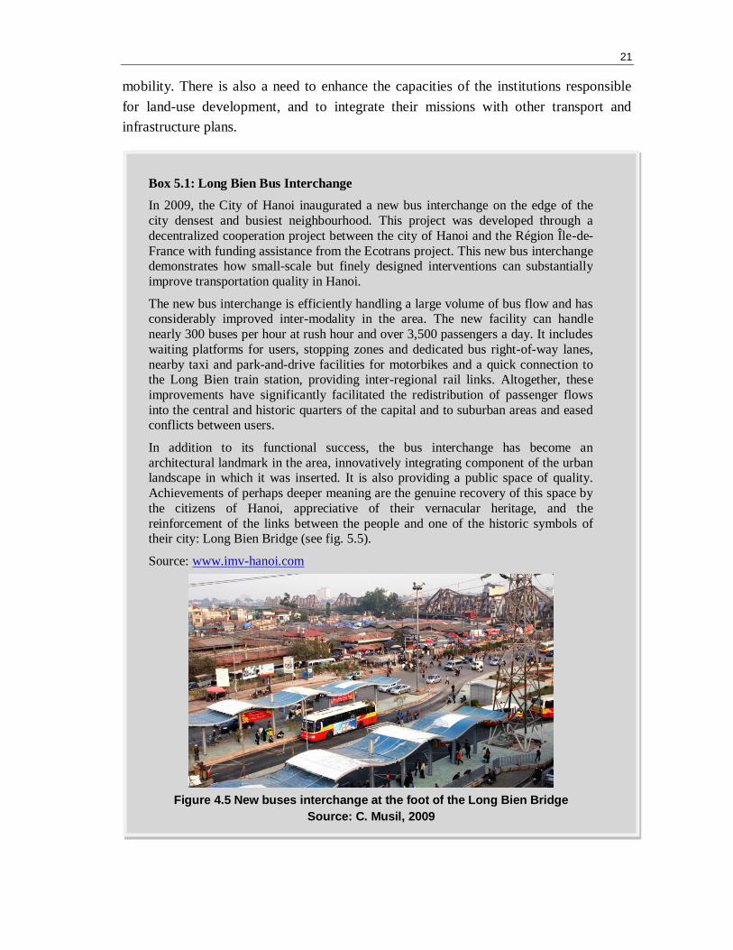
Box 5.1: Long Bien Bus Interchange
In 2009, the City of Hanoi inaugurated a new bus interchange on the edge of the
city densest and busiest neighbourhood. This project was developed through a
decentralized cooperation project between the city of Hanoi and the Région Île-de-
France with funding assistance from the Ecotrans project. This new bus interchange demonstrates how small-scale but finely designed interventions can substantially
improve transportation quality in Hanoi.
The new bus interchange is efficiently handling a large volume of bus flow and has considerably improved inter-modality in the area. The new facility can handle
nearly 300 buses per hour at rush hour and over 3,500 passengers a day. It includes
waiting platforms for users, stopping zones and dedicated bus right-of-way lanes,
nearby taxi and park-and-drive facilities for motorbikes and a quick connection to the Long Bien train station, providing inter-regional rail links. Altogether, these
improvements have significantly facilitated the redistribution of passenger flows
into the central and historic quarters of the capital and to suburban areas and eased conflicts between users.
In addition to its functional success, the bus interchange has become an
architectural landmark in the area, innovatively integrating component of the urban landscape in which it was inserted. It is also providing a public space of quality.
Achievements of perhaps deeper meaning are the genuine recovery of this space by
the citizens of Hanoi, appreciative of their vernacular heritage, and the
reinforcement of the links between the people and one of the historic symbols of their city: Long Bien Bridge (see fig. 5.5).
Source: www.imv-hanoi.com
Figure 4.5 New buses interchange at the foot of the Long Bien Bridge
Source: C. Musil, 2009

5. HOUSING PROVISION
Urban housing is a perennial problem in Hanoi. The issue can be traced back to the
subsidy era when the urban housing sector was allocated a meagre part of state
resources. This was compounded by a subsequent 30 years of wartime economy and the
destruction of buildings by bombing (1945-1975) (Papin 2001; Thrift and Forbes 1986).
By the late 1980s, the acute lack of housing space manifested in population densities
reaching 30,000 persons/km2 in the inner city (Gubry et al. 2008). Inevitably, this
under-investment in housing by a centralized state that kept promising a rapidly
growing urban population the ―right to shelter‖ became a source of popular discontent
(Dao Thi Thu Huong 1999).
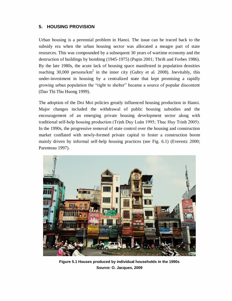
The adoption of the Doi Moi policies greatly influenced housing production in Hanoi.
Major changes included the withdrawal of public housing subsidies and the
encouragement of an emerging private housing development sector along with
traditional self-help housing production (Trịnh Duy Luân 1995; Thuc Huy Trinh 2005).
In the 1990s, the progressive removal of state control over the housing and construction
market conflated with newly-formed private capital to foster a construction boom
mainly driven by informal self-help housing practices (see Fig. 6.1) (Everestz 2000;
Parenteau 1997).
Figure 5.1 Houses produced by individual households in the 1990s
Source: O. Jacques, 2009
24
By 2000, over 70% of the residential floor area built in Hanoi was produced by private
households using their own funds (Geertman 2007). Most of this housing production
took place without construction permits (Koh 2006). Moreover, by the early 2000s, as
much as 90% of the houses in Hanoi did not have proper housing ownership and land
use-rights certificates8 (Luong Thi Hong Hanh 2001).
This self-help housing production contributed to decrease unsustainable housing
densities in the inner city. Between 2000 and 2008, average housing areas per capita
went up from 4.7 m2 to 7m
2 (VNS 2009; JBIC 1999). Yet, self-help housing has
systematically been appraised by local experts as a sub-optimal answer to the housing
shortage in Hanoi. One of the main problems is that a large proportion of the dwellings
so produced do not qualify for basic neighbourhood infrastructures, including
environmental utilities and services such as clean water and electricity. The spatial
landscape ensuing from this informal urbanization is also considered as disorderly and
unsuitable for the capital city of a modern, developed, and civilized Vietnamese nation
(PHC 2000; Nguyen Xuan Mai 2001; Lưu Trọng Hải 1995).
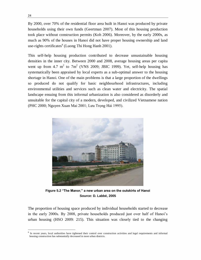
Figure 5.2 “The Manor,” a new urban area on the outskirts of Hanoi
Source: D. Labbé, 2005
The proportion of housing space produced by individual households started to decrease
in the early 2000s. By 2008, private households produced just over half of Hanoi’s
urban housing (HSO 2009: 215). This situation was closely tied to the changing
8 In recent years, local authorities have tightened their control over construction activities and legal requirements and informal housing construction has substantially decreased in most urban districts.
25
dynamic of Hanoi’s housing production during the same period. By the late 1990s,
central and municipal authorities developed an urban development model referred to as
―new urban areas‖ (khu do thi moi, hereafter NUA). NUAs are large-scale integrated
developments displaying standardized urban forms and consumer-oriented architecture
(Douglass and Huang 2007; Waibel 2006). They are characterized by the use of a so-
called ―synchronous planning approach‖ where the infrastructure system and public
facilities are developed concurrently to mixed-use residential constructions (see Fig.
6.2).
Over the last decade, over a hundred NUAs have been built around Hanoi, some
covering only a few hectares and others covering large expanses of territory and
constituting self-contained satellite towns. These projects are, for the most part, invested
by domestic enterprises, including a large number of former state-owned construction
companies. Yet, in recent years, an increasing number of projects have involved foreign
capital originating from the East and Southeast Asian regions (especially Korea,
Taiwan, and Singapore) (see Box 6.1).
Underpinning the original NUA initiative is the following idea: by supplying good
quality housing affordable for all strata of the urban population and located in planned
―modern‖ environments, informal urbanization practices would be progressively
marginalized and eventually superseded by a state-guided vision of the urban (Pandolfi
2001). Unfortunately, since its implementation, this initiative has not managed to meet
the needs of the ever-growing number of households for dwellings in the capital city.
Demand continues to outstrip the supply of housing in NUAs, which in turn fosters
speculation. Most NUA villas and apartments are sold off-plan and then re-sold many
times prior to completion.
Shortage in housing supply has pushed prices up in a succession of so-called land and
housing fever periods (Hoang Thi Lich 1999). From 1991 to 1992, prices increased
tenfold and from 2001 to 2004, shot up 500% (Hoang Thanh 2007). Hanoi’s land and
housing prices are still among the highest in the region. In 2007, a house in the old city
was selling for about US$4500-5000 per square metre, an apartment in a mid-range
high-rise building at the periphery for about US$1000-1500 per square metre, and an
apartment in a lower-range resettlement building for about US$800 per square metre
(Tien Manh 2007).
26
In the current housing market, households with enough capital or good connections to
the state are seizing opportunities to improve their lives, constructing many buildings
themselves and taking advantage of regulatory loopholes in order to speculate in the
land market. But others, looking for affordable housing, are finding that the cost of even
modest housing has become much steeper. The poor, in particular, encounter great
difficulties to access housing (see Box 6.2).
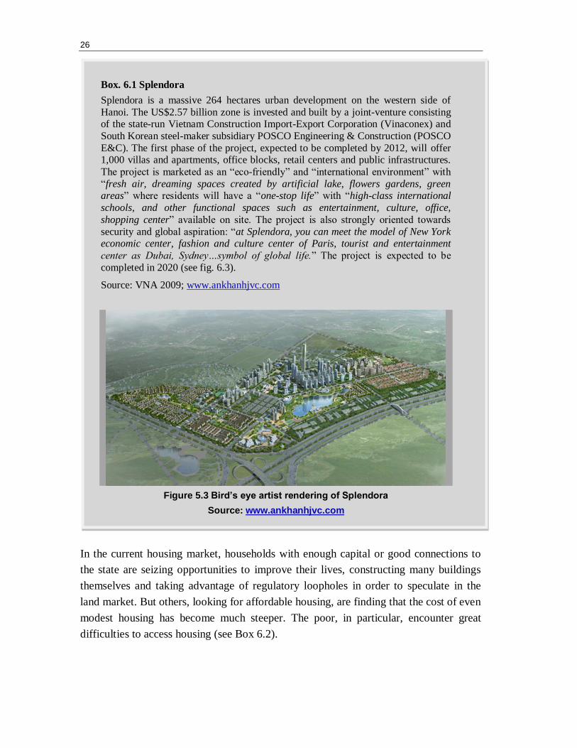
Box. 6.1 Splendora
Splendora is a massive 264 hectares urban development on the western side of
Hanoi. The US$2.57 billion zone is invested and built by a joint-venture consisting of the state-run Vietnam Construction Import-Export Corporation (Vinaconex) and
South Korean steel-maker subsidiary POSCO Engineering & Construction (POSCO
E&C). The first phase of the project, expected to be completed by 2012, will offer 1,000 villas and apartments, office blocks, retail centers and public infrastructures.
The project is marketed as an ―eco-friendly‖ and ―international environment‖ with
―fresh air, dreaming spaces created by artificial lake, flowers gardens, green areas‖ where residents will have a ―one-stop life‖ with ―high-class international
schools, and other functional spaces such as entertainment, culture, office,
shopping center‖ available on site. The project is also strongly oriented towards
security and global aspiration: ―at Splendora, you can meet the model of New York economic center, fashion and culture center of Paris, tourist and entertainment
center as Dubai, Sydney…symbol of global life.‖ The project is expected to be
completed in 2020 (see fig. 6.3).
Source: VNA 2009; www.ankhanhjvc.com
Figure 5.3 Bird’s eye artist rendering of Splendora
Source: www.ankhanhjvc.com
27
In 2009, Hanoi municipal authorities addressed this situation by announcing plans to
build 15,500 apartments totalling 1.5 million square metres to shelter students, workers
in industrial zones, and low-income Hanoi residents by 2015 (Quynh Nga 2009).
However, the federal government is not planning to subsidize housing directly, and
financial mechanisms to entice private developers to supply affordable housing are yet
to be defined. This is no small challenge. In a market where land values are on the rise
and with a private sector oriented toward more affluent households, one can hardly
expect the market to supply affordable housing. As noted in a recent interview by the
chairman of the Vietnam Construction Association, Pham Si Liem: ―Investors need to
turn a profit. One square metre of commercial space can be sold from VND10-20
million (US$600-1,200), while it’s between VND 6-7 million ($350-410) for social
housing. Who would want to build these homes?‖ In the current market system, seeking
the highest possible returns on land development, the poor are still left to fend for
themselves.
Box 6.2: Out of Reach
Twenty-nine year-old Nguyen Thu Nga can only dream of owning an apartment in
Ha Noi. Nga and her husband are currently renting a small apartment in a five-storey building in Thanh Xuan District. They earn a total of VND 5 million ($294)
per month, barely enough to get by with their small child in the city: "I’ve heard a
lot about the Government’s project to build cheap houses for low-income earners; however, it’s still out of my budget," said Nga. Nga and her family have no monthly
savings to purchase a 50 square meters apartment in the capital, which would run
about VND 300 million ($17,600).
Source: VNS 2009

6. PERI-URBAN INTEGRATION
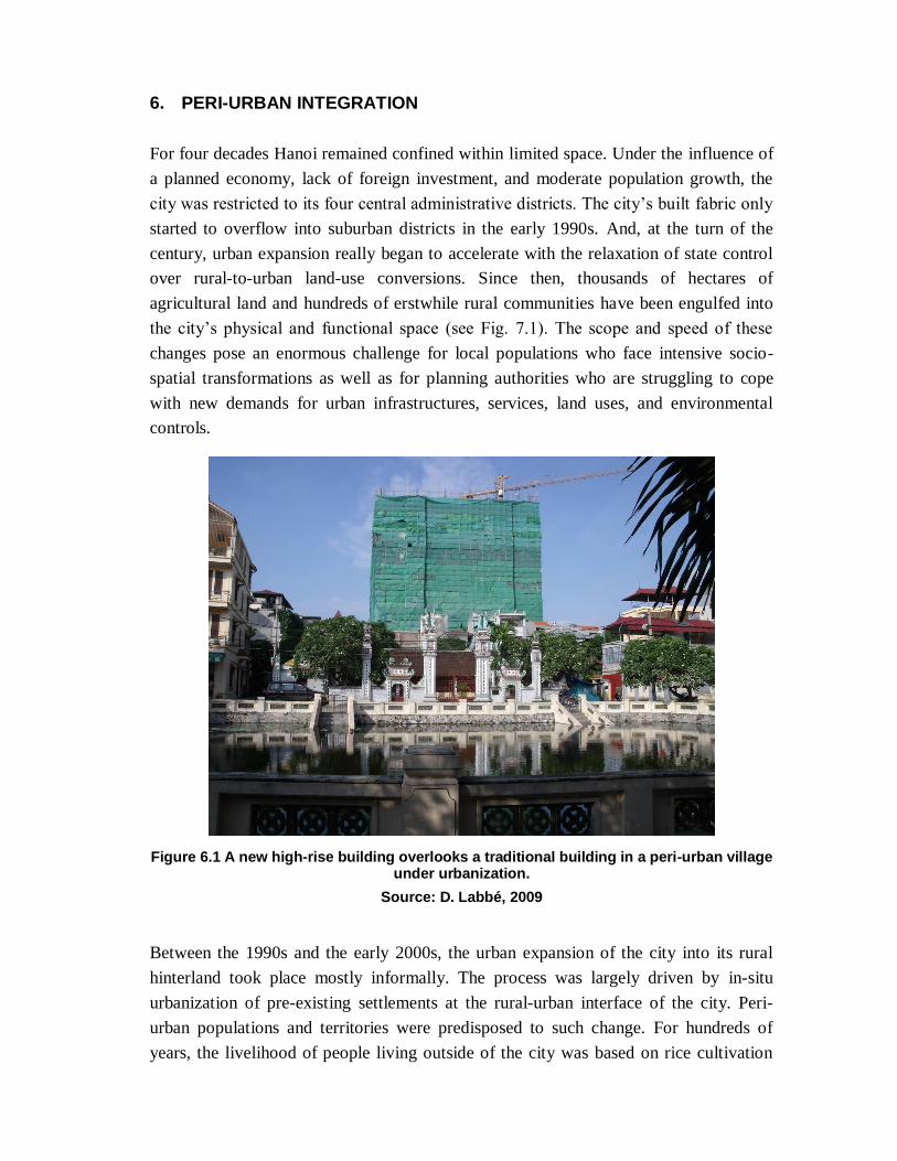
For four decades Hanoi remained confined within limited space. Under the influence of
a planned economy, lack of foreign investment, and moderate population growth, the
city was restricted to its four central administrative districts. The city’s built fabric only
started to overflow into suburban districts in the early 1990s. And, at the turn of the
century, urban expansion really began to accelerate with the relaxation of state control
over rural-to-urban land-use conversions. Since then, thousands of hectares of
agricultural land and hundreds of erstwhile rural communities have been engulfed into
the city’s physical and functional space (see Fig. 7.1). The scope and speed of these
changes pose an enormous challenge for local populations who face intensive socio-
spatial transformations as well as for planning authorities who are struggling to cope
with new demands for urban infrastructures, services, land uses, and environmental
controls.
Figure 6.1 A new high-rise building overlooks a traditional building in a peri-urban village under urbanization.
Source: D. Labbé, 2009
Between the 1990s and the early 2000s, the urban expansion of the city into its rural
hinterland took place mostly informally. The process was largely driven by in-situ
urbanization of pre-existing settlements at the rural-urban interface of the city. Peri-
urban populations and territories were predisposed to such change. For hundreds of
years, the livelihood of people living outside of the city was based on rice cultivation
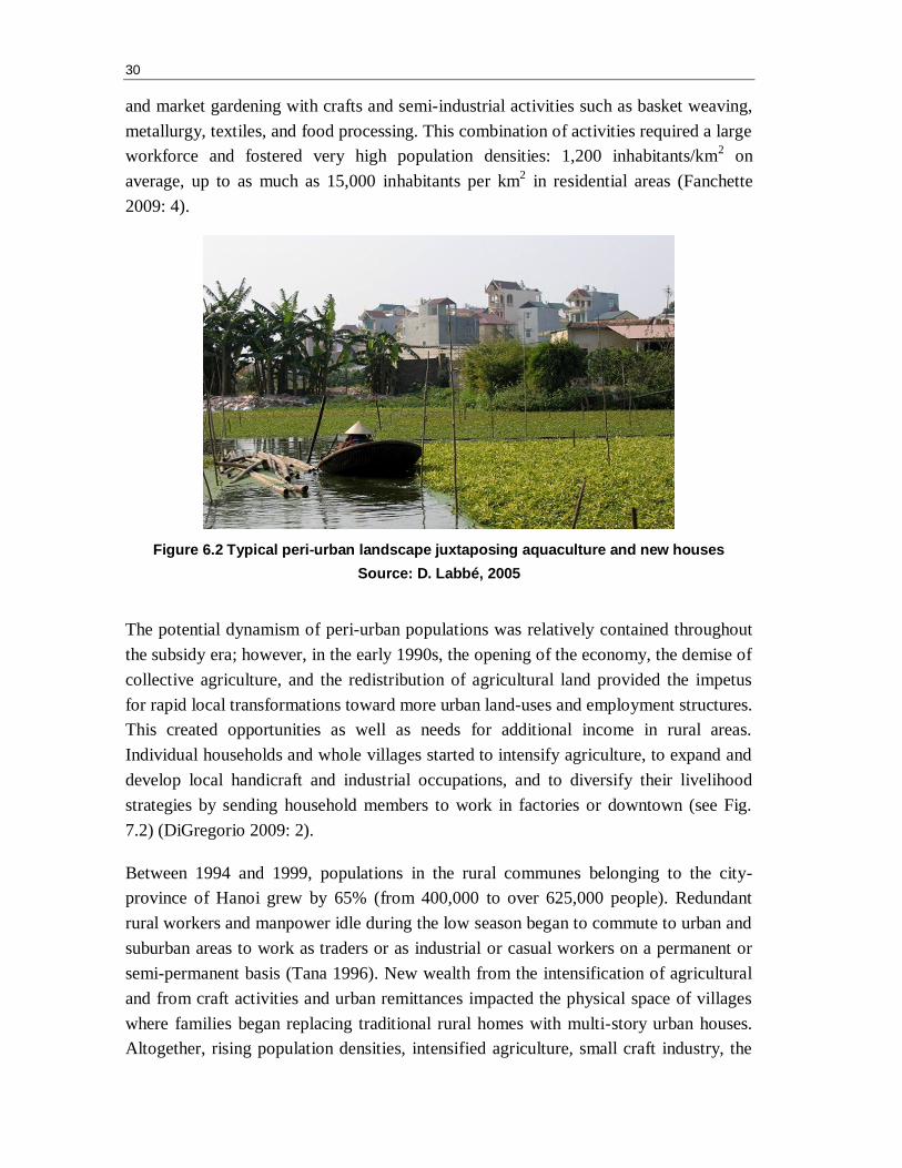
30
and market gardening with crafts and semi-industrial activities such as basket weaving,
metallurgy, textiles, and food processing. This combination of activities required a large
workforce and fostered very high population densities: 1,200 inhabitants/km2 on
average, up to as much as 15,000 inhabitants per km2 in residential areas (Fanchette
2009: 4).
Figure 6.2 Typical peri-urban landscape juxtaposing aquaculture and new houses
Source: D. Labbé, 2005
The potential dynamism of peri-urban populations was relatively contained throughout
the subsidy era; however, in the early 1990s, the opening of the economy, the demise of
collective agriculture, and the redistribution of agricultural land provided the impetus
for rapid local transformations toward more urban land-uses and employment structures.
This created opportunities as well as needs for additional income in rural areas.
Individual households and whole villages started to intensify agriculture, to expand and
develop local handicraft and industrial occupations, and to diversify their livelihood
strategies by sending household members to work in factories or downtown (see Fig.
7.2) (DiGregorio 2009: 2).
Between 1994 and 1999, populations in the rural communes belonging to the city-
province of Hanoi grew by 65% (from 400,000 to over 625,000 people). Redundant
rural workers and manpower idle during the low season began to commute to urban and
suburban areas to work as traders or as industrial or casual workers on a permanent or
semi-permanent basis (Tana 1996). New wealth from the intensification of agricultural
and from craft activities and urban remittances impacted the physical space of villages
where families began replacing traditional rural homes with multi-story urban houses.
Altogether, rising population densities, intensified agriculture, small craft industry, the
31
provision of new local services, new rural incomes from remittances, and a housing
construction boom converged to spur an endogenous process of urbanization at the
village level that paralleled the urban growth process as it occurs elsewhere (DiGregorio
et al. 2003).
Throughout the 1990s, conversion of agricultural land to urban uses took place
informally at a very small scale. The formal rural-to-urban conversion of large tracts of
agricultural land was tightly restricted by the state, requiring approval from the Ministry
of Natural Resources. At the beginning of the 2000s, the state relaxed its grasp on the
management of these spaces and, in 2006, decentralized the power to approve and
convert land uses down to provincial and municipal governments. This fuelled a real
estate market boom all over Hanoi’s peri-urban territories.
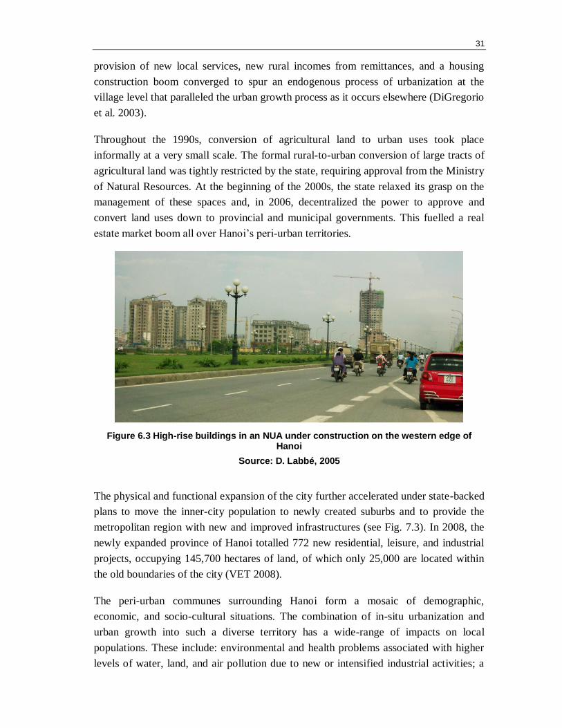
Figure 6.3 High-rise buildings in an NUA under construction on the western edge of Hanoi
Source: D. Labbé, 2005
The physical and functional expansion of the city further accelerated under state-backed
plans to move the inner-city population to newly created suburbs and to provide the
metropolitan region with new and improved infrastructures (see Fig. 7.3). In 2008, the
newly expanded province of Hanoi totalled 772 new residential, leisure, and industrial
projects, occupying 145,700 hectares of land, of which only 25,000 are located within
the old boundaries of the city (VET 2008).
The peri-urban communes surrounding Hanoi form a mosaic of demographic,
economic, and socio-cultural situations. The combination of in-situ urbanization and
urban growth into such a diverse territory has a wide-range of impacts on local
populations. These include: environmental and health problems associated with higher
levels of water, land, and air pollution due to new or intensified industrial activities; a
32
sharp rise in land values, limiting the possibility of the peri-urban population to afford
spaces for residential purposes or for the development of economic activities; social
stresses on rural communities suddenly receiving large numbers of rural migrants and
suburbanizing dwellers; rise in what the Vietnamese people refer to as ―social evils‖
such as drugs and prostitution, crime, and gambling (Rossi and Pham Van Cu 2002;
Quertamp 2003).
One of the core issues associated with urban growth relates to the revoking of
agricultural land-use rights in favour of urban uses. The appropriation of agricultural
areas for industrialization and urbanization purposes has accelerated rapidly in recent
years. By 2006, the Red River Delta economic region was leading the way in the
country with 4.4% of its agricultural land having been converted to urban and industrial
land (Coulthart et al. 2006). By the end of 2010, Hanoi is expected to have converted
11,000 hectares of land (mostly annual cropland in rural areas) to industrial and urban
land. It is estimated that these conversions will result in the loss of agriculture-related
work of some 150,000 farmers, a figure likely to increase dramatically following the
integration of the former province of Ha Tay within the boundary of the national
capital’s city-province.
As in China (Guo 2001), the appropriation of agricultural land-use rights in Vietnam
has become a major source of conflicts between different parts of society including
villagers, public and private land developers, communal, district, and provincial
authorities as well as the central state. As noted by Kerkvliet (2006: 297) ―the
grievances expressed by villagers are often entangled in corruption cases, local
officials’ abuses, lack of consultation, lack of forewarning about land-use right revoking
or resettlement, and questions about how land use compensation should be carried out,
who has the power to determine land values, and who should participate in the decision-
making related to land uses.‖
Popular discontent is probably partly responsible for the successive revisions of the
legislative framework surrounding the process of revoking land-use rights (Kim 2009).
Compensation rules and the methods for calculating the compensations are evolving
rapidly and the packages offered by the state and by developers are getting more diverse
and generous. The latest change in the legislation on land clearance took place in
August 2009 with the issuance of Decree 69, which aims to better protect high-
productivity cropland from development, ensure earlier forewarnings of affected
populations in case of land recovery, and diversify the compensation packages offered
to displaced populations. However, to what extent this new legislation will mitigate land
clearance issues around Hanoi remains to be seen.
33
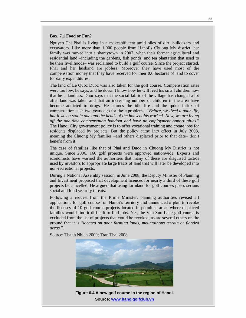
Box. 7.1 Food or Fun?
Nguyen Thi Phai is living in a makeshift tent amid piles of dirt, bulldozers and excavators. Like more than 1,000 people from Hanoi’s Chuong My district, her
family was moved into a shantytown in 2007, when their former agricultural and
residential land –including the gardens, fish ponds, and tea plantation that used to
be their livelihoods– was reclaimed to build a golf course. Since the project started, Phai and her husband are jobless. Moreover they have used most of the
compensation money that they have received for their 0.6 hectares of land to cover
for daily expenditures.
The land of Le Quoc Duoc was also taken for the golf course. Compensation rates
were too low, he says, and he doesn’t know how he will feed his small children now
that he is landless. Duoc says that the social fabric of the village has changed a lot after land was taken and that an increasing number of children in the area have
become addicted to drugs. He blames the idle life and the quick influx of
compensation cash two years ago for these problems. ―Before, we lived a poor life, but it was a stable one and the heads of the households worked. Now, we are living
off the one-time compensation handout and have no employment opportunities.‖
The Hanoi City government policy is to offer vocational training and create jobs for residents displaced by projects. But the policy came into effect in July 2008,
meaning the Chuong My families –and others displaced prior to that date– don’t
benefit from it.
The case of families like that of Phai and Duoc in Chuong My District is not
unique. Since 2006, 166 golf projects were approved nationwide. Experts and
economists have warned the authorities that many of these are disguised tactics used by investors to appropriate large tracts of land that will later be developed into
non-recreational projects.
During a National Assembly session, in June 2008, the Deputy Minister of Planning and Investment proposed that development licences for nearly a third of these golf
projects be cancelled. He argued that using farmland for golf courses poses serious
social and food security threats.
Following a request from the Prime Minister, planning authorities revised all
applications for golf courses on Hanoi’s territory and announced a plan to revoke
the licenses of 10 golf course projects located in populous areas where displaced families would find it difficult to find jobs. Yet, the Van Son Lake golf course is
excluded from the list of projects that could be revoked, as are several others on the
ground that it is ―located on poor farming lands, mountainous terrain or flooded areas.‖.
Source: Thanh Nhien 2009; Tran Thai 2008
Figure 6.4 A new golf course in the region of Hanoi.
Source: www.hanoigolfclub.vn

7. CONCLUSION AND RESEARCH AVENUES
A historical shift from an agrarian to an urban society is now well underway in Vietnam
in general and in the region of Hanoi in particular. This transition engenders
transformations of society, the economy, and political institutions as well as the built
and natural environment in both rural regions and urban centres. Past policies to limit
urbanization through attempts to control population mobility have now given way to an
understanding of urbanization as an irreversible process that can contribute positively to
development through increases in material and economic welfare, industrialization, and
economic efficiency linked to the agglomeration economies of cities.
Yet benefits from urbanization come at a price. As shown in this report, the problems
associated with urbanization in Hanoi are multi-faceted and call for innovative solutions
that are appropriate to the specific context and resources of this region. Over the last
two decades, some urban planning issues have received considerable attention from
researchers, government agencies, and development funding institutions. The most
salient among these are transportation and telecommunication infrastructure
development, public transit, and heritage preservation (as discussed in sections 3 and 5
of this report). Yet, many issues associated with the urban transition in Vietnam still call
for more research and concerted action. By way of conclusion, the following briefly
outlines five areas which deserve to be put on future research agendas.
7.1 Integrating Rural and Urban Regional Planning
Even with the fast pace of urbanization, the region of Hanoi will continue to have a very
large rural population for many decades. Currently, rural regions in Vietnam continue to
increase in population numbers, though by about half the amount than those accruing in
cities (UNCHS 2002: 5-1). A key question in this regard is how to overcome the
traditional dichotomy between rural and urban planning, allowing to take advantage of
rural-urban linkages such to benefit both rural and urban areas. This entails exploring
how the national space-economy—including agriculture and craft activities—can be
best integrated into the international economy. It also requires improving the regional
distribution of the benefits of urbanization. Particularly important, in this regard, are the
peri-urban areas (discussed in Section 7), which absorb most of the urban population
increase but which are poorly prepared to cope with the high urban management
demands arising in them.
36
7.2 Updating Urban Management Mechanisms
Effective urban planning for the city-province of Hanoi is currently at a crossroads and
must take into account the considerable changes brought about by two decades of
transitioning toward a market economy. These include: heightened integration into more
volatile regional and global economic systems; unrestrained investment in real estate;
the need for major cities to be competitive in an international context; and loosened
control on private economic activities and population movements.
The current planning mechanisms, inherited from the command-and-control era, are
obsolete. As it stands, the Ministry of Construction in charge of planning for the region
of Hanoi formulates master plans, the ideal or final outcome of which is to be achieved
a targeted two decades later. This top-down process places strong emphasis on the
spatial arrangement of buildings in a very prescriptive way without providing for
mechanisms that can ensure that such investment is in the public interest. As noted by
Wilson (2009), construction master plans have a number of other weaknesses: They
give little consideration to the visual, social, or economic suitability of proposed
developments, in addition to being poorly aligned with national or regional
development goals.9 In all, the master plan approach is rather static, i.e., it can hardly
adjust to changing conditions or guide the market forces that increasingly dictate the
shape, form, and intensity of urban development in the capital city region.
What is required is a fresh look at different planning mechanisms with the aim of
crafting an approach that will best help Hanoi authorities manage the development of
the city-region, ensuring that it can harness opportunities and mitigate emerging
problems in timely and context-sensitive manners. This includes thinking about what
kind of institutional engineering is needed to implement a new planning approach, what
financial and human resources are required, and how professionals in the built
environment and urban administration fields must be trained in order to ensure the
ongoing implementation of such an approach.
7.3 Improving Urban Land Development Planning and Coordination
At the city scale, there is a need to explore ways to improve the coordination of
investments across sectors in the urban space to ensure appropriate land development
patterns, including the conservation of open and public spaces as well as historically
important sites and elements of the built environment (as discussed in sections 3 and 4).
9 This is partly due to compartmentalization into various poorly coordinated sectors. For instance, construction planning does not include land-use planning or management as this is the responsibility of the Ministry of Natural Resources and Environment.
37
As exemplified in the case of the Thuong Dinh Ward’s Playground Upgrade (Box 4.1),
it might be fruitful to explore ways to improve coordination, not only among
government agencies but also with communities, in order to ensure an appropriate fit
with their varied situations. In the current context of steep increases in urban land
values, providing serviced land for low-income family housing is a challenge that needs
to be tackled in the short-term. Beyond the issue of coordination, it is also necessary to
think about how to involve society and private enterprises in scaling up the capacity to
supply enough housing for the urban population of tomorrow.
7.4 Understanding and Dealing with Urban Poverty
Poverty is more and more present in urban contexts in Vietnam, and this shift is putting
new issues on the agendas of urban planners. This raises several questions in particular:
How can we improve the situation of unregistered migrants living in squatter and low-
income settlements? What can households with members lacking formal education and
marketable skills do to integrate into the urban economy? How is the degradation of the
environment associated with the urbanization impacting the health of the poor? What
are the current (and potential) roles of rural-urban linkages in the management of
poverty by internal migrants? How can community efforts be better linked with state
programs in environmental management, housing, education and training, and social
services to improve the lives of the urban poor?
7.5 Getting Ready to Face Climate Change
Both scientific studies and interviews with local populations indicate that Vietnam
experienced important weather changes over the last 40 years (Zink 2009). These are
accompanied by an increase in natural disasters and extreme weather events. There is no
firm evidence that recent weather changes which have taken place over the last few
decades are the result of human-caused global warming (Oxfam 2009). However, the
experience of dealing with extreme weather and natural disasters over the last few
decades may well be a prelude to what Vietnam will face in the near future.
Vietnam is indeed among the world’s top 10 countries that are the most vulnerable to
climate change. Global weather conditions in Vietnam are indeed expected to become
both more extreme and unpredictable, inducing a variety of natural hazards across the
country. A report by the World Bank ranks Vietnam first in terms of potential impact of
climate change on population, GDP, urban extent, and wetland areas. The authors
maintain that the consequences of climate change for Vietnam are ―potentially
catastrophic‖ (Dasgupta et al. 2007:44).
38
So far, climate policy in Vietnam is designed mainly for national scale application and
for vulnerable populations in rural areas, with research by and large neglecting the
effects and challenges of climate change in urbanized and urbanizing areas. Local media
regularly cover problems caused by storms and floods in Vietnamese cities (e.g., health
and sanitation issues, interruption of schooling, damage to buildings and infrastructure).
At the same time, existing research provides little information on the scope of these
problems and on coping mechanisms developed by the authorities and by local people.
As discussed earlier, urban and peri-urban areas present unique characteristics and
therefore call for more research in order to identify specific mitigation and adaptation
strategies adapted to their population distributions and densities, economic activities,
buildings, and infrastructures.
A recent report by the World Bank states that the most adverse impacts of climate
change are likely to be in urban areas where people, resources, and infrastructures are
concentrated (Prasad et al. 2009: xiv). Hanoi is particularly at risk in this regard as it is
situated in a low-lying area near the mouth of a major and unpredictable river (the Red
River). This places Hanoi at greater risk to current and projected climate hazards such
as cyclones, high winds, floodings, coastal erosion and deposition, and sea-level rise
(Gubry 2008).
At the technical level, much remains to be done in Hanoi in terms of identifying flood-
safe areas and formulating policies to restrict the urban expansion of these zones. There
is also a need to explore how buildings, physical protection, and design standards can be
applied to ensure that floods and extreme events do not impair populations and strategic
functions. This is particularly problematic in the case of spontaneous human settlements
that often expand beyond state control in flood-prone zones surrounding cities. Another
issue in need of more research is that of ―climate refugees.‖ Climate change may well
accelerate rural-to-urban migration in Vietnam, with rural households affected by
natural hazards likely to migrate to urban agglomerations. In that case, how would
Hanoi cope with a larger flow of rural migrants? There is also the need to more
carefully assess the role played by natural systems within urban areas in providing
protection and mitigation of flood events. These are only a few of the challenges that
merit further research in order to help Vietnamese authorities and urban populations
prepare for climate change
References
ABD. 2006. Vietnam: Hanoi Urban Transport Development Project. Hanoi, Asian Development Bank.
AFD. 2008. Hanoi metro line. Agence Française de Développement. Retrieved from: www.afd.fr
Coulthart, A., Nguyen Quang, et al. 2006. Urban Development Strategy: Meeting the challenges of rapid urbanization and the transition to a market oriented economy, World Bank.
Dao Thi Thu Huong. 1999. The Development of Housing Sector in Vietnam. Lund, Sweden (unpublished manuscript) Retrieved from www.hdm.lth.se
Dasgupta, S., B. Laplante, et al. 2007. The Impact of Sea Level Rise on Developing Countries: A Comparative Analysis, World Bank Policy Research Working Paper 4136, February 2007.
DiGregorio, M. 2009. On the Edge: Facing the Urban Transition in Hanoi's Western Suburbs (Preliminary Report). Hanoi, The Ford Foundation.
DiGregorio, M., S. J. Leisz, et al. 2003. The Invisible Urban Transition: Rural Urbanization in the Red River Delta. Paper presented at "Creating Better Cities in the 21th Century”, 7th International Congress of Asian Planning Schools Association, Hanoi, 12-14 September.
Douglass, M. and L. Huang. 2007. "Globalizing the City in Southeast Asia: Utopia on the Urban Edge - The Case of Phu My Hung, Saigon." International Journal of Asian-Pacific Studies 3(2): 1-42.
Drummond, L. B. W. 2000. "Street scenes: Practices of public and private space in urban Vietnam." Urban Studies 37(12): 2377-2391.
Everestz, H. 2000. Popular Housing in Hanoi. Shelter and Living in Hanoi. Luan, T. D. and H. Schenk (eds). Hanoi, Cultural Publishing House: 57-84.
Fanchette, S. 2009. Conservation of Traditional Villages: The Necessities in Urban Planning Projects in Hà Nội. International Workshop on Hanoi: A Livable City for All, Hanoi, July 1-2, 2009.
Geertman, S. 2007. The Self-Organizing City in Vietnam: Processes of Change and Transformation in Housing in Hanoi. Eindhoven, University of Technology, PhD dissertation.
Gubry, P. 2008. L'urbanisation en Asie du sud-est: Pistes de recherche à partir de l'expérience vietnamienne. Paper presented at "Les tendances de l'urbanisation et de la périurbanisation en Asie du Sud-Est", Ho Chi Minh City, 9-11 December 2008.
Gubry, P., Lê Thi Huong, et al., Eds. 2008. Bouger pour vivre mieux: Les mobilités intra-urbaines à Hô Chi Minh Villet et Hanoi (Viêt-Nam). Hanoi, Éditions de l'Université nationale d'économie.
Gubry, P., B. Lortic, et al. 2002. Hanoi: Population et migrations intra-urbaines. Regards croisés sur Hanoi: Transition, spécificité urbaine et choix de développement, Hanoi, Institut des Métiers de la Ville.
Guo, X. 2001. "Land Expropriation and Rural Conflicts in China." The China Quarterly 166: 422-439.
HAIDEP. 2005. Hanoi Urban Environment Fact Book: Opinions of 20,000 Households. Hanoi, The Comprehensive Urban Development Programme in Hanoi City (HAIDEP).
HAIDEP. 2007. The Comprehensive Urban Development Programme in Hanoi Capital City of the Socialist Republic of Vietnam (HAIDEP). Hanoi, JICA & People's Committee of Hanoi.
Hieu Nguyen Ngoc. 2009. "Pimp my ride." Vietnam Financial Review February 2009: retrieved from: www.vfr.vn
40
Hoang Thanh. 2007. "Are Real Estate Prices Wavering." Vietnam Economic News 7 (18): 36.
Hoang Thi Lich. 1999. Housing in Hanoi. Women’s Rights to House and Land: China, Laos, Vietnam. Tinker, I. and G. Summerfield (eds). London, Lynne Rienner: 77-94.
HSO. 2009. Niên giám thống kê 2008 [Hanoi Statistical Yearbook 2008]. Ha Noi, Cục thống kê thành phố Hà Nội [Hanoi Statistical Office].
ISTED. 2006. Transports urbains: Rapport d'activités. Paris, Institut des Sciences et des Techniques de l'Équipement et de l'Environnement pour le Développement.
JBIC. 1999. Urban Development and Housing Sector in Viet Nam, JBIC Research Paper No.3. Hanoi, Research Institute for Development and Finance, Japan Bank for International Cooperation.
JBIC. 1999. Urban Public Transportation in Vietnam: Improving Regulatory Framework, JBIC Research Paper No. 4, Japan Bank for International Cooperation.
Kim, A. M. 2009. The role of Decentralization and Discourse in Land Compensation Changes in Transitional Vietnam. Property & Property Rights in Vietnam, Harvard University, May 23-24, 2009.
Koh, D. W. H. 2006. Wards of Hanoi. Singapore, Institute of Southeast Asian Studies.
Koh, D. W. H. 2008. The pavement as civic space: History and dynamics in the city of Hanoi. Globalization, the city and civil society in Pacific Asia. Douglass, M. et al (eds). London, Routledge: 145-74.
Kurfürst, S. 2009. Uses and Abuses of Public Space: Street Trading in Hanoi and the Role of Municipal Authorities. Workshop: “Urban Development in a Globalising World – Overcoming the Formal-Informal Divide”, Berlin, 12-13 June.
Ledent, J. 2002. La population: évolution passée et développement futur. Hanoi: enjeux modernes d'une ville millénaire. Charbonneau, F. and D. Hau (eds). Montréal, Trames: 64-86.
Logan, W. S. 1994. Hanoi townscape: symbolic imagery in Vietnam's capital. Cultural Identity and urban change in Southast Asia: Interpretative essays. Askew, M. and W. S. Logan (eds). Victoria, Australie, Deakin University Press: 44-69.
Logan, W. S. 2000. Hanoi: Biography of a city. Syndey, UNSW Press.
Luong Thi Hong Hanh. 2001. Improving Privatisation of Housing Stock in Vietnam: A Case Study of Hanoi. Lund, Sweden (unpublished manuscript) Retrieved May 6th 2005 from www.hdm.lth.se/.
Lưu Trọng Hải. 1995. "Nha o rieng le” [Private housing]. Kien Truc 5(55): 24-26.
Maclaren, F., T. 1996. Building Transformation in Hanoi's French Colonial Quarter: Can the Past Survive? Urban Southeast Asia: Past, present and future, Berkeley.
MoC. 2009. Định hướng quy hoạch tổng thể phát triển đô thị Việt Nam đến năm 2025 và tầm nhìn đến năm 2050. Ha Noi, Ministry of Construction.
Ngô Đưc Thọ, Nguyễn Văn Nguyên, et al. 2002. 1886-1888 Đồng Khánh địa dư chí [Descriptive geography of Đồng Khánh emperor]. Hanoi, EFEO-EPHE-Institut Han-Nôm.
Nguyên Duc Nhuan. 1978. "Désurbanisation et développement régional au Vietnam (1954-77)." International Journal of Urban and Regional Research 2: 330-50.
Nguyên Quang and D. H. Kammeir. 1997. Case study: Conservation program for the French colonial quarter in Hanoi. The Economics of Heritage: UNESCO Conference on Adaptive Re-use of Historic Properties in Asia and the Pacific, Hanoi.
Nguyen Thai Huyen. 2009. Ambition technopolitaine, projet d'urbanisme et planification urbaine: les avantages et limites d'un modèle (le cas de la région de Hanoi). Doctoriales en sciences sociales de l'Institut de recherche en développement (IRD), Hanoi, 12 decembre.
41
Nguyen Thi Hien. 2009. Community Space in Low-Income Housing Areas: A Case-Study of Hanoi, Vietnam. Hanoi [unpublished manuscript].
Nguyen Xuan Mai. 2001. Housing problem in Hanoi: Status quo and future requirements. Housing and land in Hanoi. Luan, T. D. and H. Shenk (eds). Hanoi, Cultural publishing house: 129-146.
Nishimura, Y. 1997. Urban traditions in Asia and their preservation. Preservation of Hanoi architectural heritage. Terunobu, F. et al. Hanoi, Construction publishing house: 64-73.
NXBTT. 2006. Hà Nội nét xưa [Ha Noi: allure d'antan]. Hanoi, Nhà Xuất Bản Thông Tấn [Editions de l'AVI].
Oxfam. 2009. Participatory Monitoring of Urban Poverty in Viet Nam: Synthesis Report 2008, Oxfam & ActionAid Vietnam.
Pandolfi, L. 2001. Une terre sans prix: Réforme foncière et urbanisation au Viêt-Nam, Hanoi, 1986-2000. Paris, IFU/Paris 8 (unpublished PhD dissertation).
Papin, P. 2001. Histoire de Hanoi. Paris, Fayard.
Parenteau, R., Ed. 1997. Habitat et environnement urbain au Vietnam: Hanoi et Ho Chi Minh-Ville. Paris, Karthala.
Parenteau, R. and L. Champagne, Eds. 1994. La conservation des quartiers historiques en Indochine. Paris, Karthala.
Pham Dinh Viêt. 1997. Role of cultural, historical and religious works in preservation and rehabilitation of 36 old streets of Hanoi. Preservation of Hanoi architectural heritage. Terunobu, F. et al. (eds) Hanoi, Construction publishing house: 53-58.
PHC (2000) L'aménagement global de Hanoi. Hanoi, People's Committee of Hanoi.
Prasad, N., F. Ranghieri, et al. 2009. Climate Resilient Cities: A Primer on Reducing Vulnerability to Disasters. Washington, The Workd Bank, Retrieved July 14th from http://siteresources.worldbank.org.
Quertamp, F. 2003. Ha Noi: Une péri-urbanisation paradoxale. Bordeaux, Université de Bordeaux III - Michel de Montaigne. (unpublished PhD dissertation),.
Quynh Nga. 2009. "Housing in Hanoi for Low-income People." Vietnam Economic News (37): 30-31.
Rossi, G. and Pham Van Cu. 2002. Atlas infographique de la province de Hanoi. Bordeaux, Maison d'édition de la cartographie.
Shibayama, M., G. Yonezawa, et al. 2008. Hanoi 4D Analysis in 19th and 20th Centuries: Urbanized City, Water Area, and Villages. Hanoi.
Tana, L. 1996. Peasants on the Move: Rural-Urban Migration in the Hanoi Region. Occasional Paper No. 91, Singapore, Institute of Southeast Asian Studies.
Terunobu, F., P. D. Viêt, et al., Eds. 1997. Preservation of Hanoi Architectural Heritage. Hanoi, Construction Publishing House.
Thaiutsa, B., L. Puangchit, et al. 2008. "Urban green space, street tree and heritage large tree assessment in Bangkok, Thailand." Urban Forestry & Urban Greening 7(3): 219-29.
Thanh Nhien. 2009. "18 August, 2009, Golf drives Hanoi farmers off their land." Thanh Nhien Retrived from www.thanhniennews.com
Thrift, N. and D. Forbes. 1986. The Price of War: Urbanization in Vietnam 1954-1985. London, Allen & Unwin.
Thuc Huy Trinh. 2005. Eliminating Subsidy: Shifting to a Favourable Mechanism for Housing Development In Vietnam. Source: ASEAN Association for Planning and Housing, Retrieved July 20th 2005.
42
Tien Manh. 2007. "Dappling in Real Estate." Vietnam Economic News (44): 7.
Tran Thai. 2008. "Fun or Food?" Vietnam Economic Times (May): 34-35.
Trịnh Duy Luân. 1995. The urban housing problem in Vietnam before and during «renovation». De la métropoloe au micro-territoire: gérer la complexité, gérer la diversité, Montréal, Ville et développement - Groupe interuniversitaire de Montréal.
UNCHS. 2002. The urban transition in Vietnam. Fukuoka, Japon, United Nation Centre for Human Settlements.
VET. 2008. "Go West." Vietnam Economic Times (April): 20-1.
VNA. 2009. "Hanoi‟s urban zone named „Splendora‟." Vietnam News Agency 31 August 2009
VNS. 2009. "Cheap housing remains out of reach for poor." Vietnam News, first published 02-03-2009, Retrieved from: http://vietnamnews.vnagency.com
VNS. 2009. "Living space: nation strives to guarantee each resident at least 18sq.m of housing." Vietnam News Friday August 21st, 2009
Waibel, M. 2006. "The Production of Urban Space in Vietnam's Metropolis in the course of Transition: Internationalization, Polarization and Newly Emerging Lifestyles in Vietnamese Society." Trialog (89): 43-8.
Wilson, L. 2009. Observations and suggestions regarding the proposed Hanoi capital construction masterplan to 2030 and vision to 2050. International symposium for the Hanoi capital construction master plan to 2030 and vision 2050, Hanoi, April, 21-22.
Wright, G. 1991. The Politics of Design in French Colonial Urbanism. Chicago, University of Chicago Press.
Zink, E. 2009. The makings of climate change in Vietnam: Or how global warming made money grow on family trees [unpublished manuscript].


