FATE OF CONTAMINANTS IN UNCONSOLIDATED AQUIFERS THOUGHTS ON DETERMINING THE RELEVANT PHYSICAL TRANSPORT PROCESSES AT FIELD SITES Denis LeBlanc Toxic Substances Hydrology Program With Contributions from: Brian Andraski, Barbara Bekins, Scott Christenson, Isabelle Cozzarelli, Fred Day-Lewis, Geoff Delin, Bill Herkelrath, Mary Hill, Randy Hunt, Jim Landmeyer, John Lane, Michelle Lorah, Jason Masoner, Roger Morin, Tom Reilly, Don Rosenberry, Allen Shapiro, Byron Stone, Dave Stonestrom, and Don Walter (USGS) Rose Forbes (AFCEE), Graham Fogg (UCDavis), Kamini Singha (Penn State), Chunmiao Zheng (UAlabama), Brewster Conant (UWaterloo), Pete Shanahan (MIT), and Dick Willey and Kathy Hess (USEPA)
Transcript
FATE OF CONTAMINANTS IN UNCONSOLIDATED AQUIFERS
THOUGHTS ON DETERMINING THE RELEVANT PHYSICAL TRANSPORT PROCESSES AT FIELD SITES
Denis LeBlanc
Toxic Substances Hydrology Program
With Contributions from:
Brian Andraski, Barbara Bekins, Scott Christenson, Isabelle Cozzarelli, Fred Day-Lewis, Geoff Delin, Bill Herkelrath, Mary Hill, Randy Hunt,
Jim Landmeyer, John Lane, Michelle Lorah, Jason Masoner, Roger Morin, Tom Reilly, Don Rosenberry, Allen Shapiro, Byron Stone,
Dave Stonestrom, and Don Walter (USGS)
Rose Forbes (AFCEE), Graham Fogg
(UCDavis), Kamini
Singha
(Penn State),
Chunmiao
Zheng
(UAlabama), Brewster Conant (UWaterloo), Pete Shanahan (MIT), and Dick Willey and Kathy Hess (USEPA)
Understanding the flow system is critical•
Geohydrologic
framework
•
Sources and sinks of water•
Local and regional boundaries
•
Patterns and rates of flow
MADE site, MSMADE site, MS
Naval Air Warfare CenterNaval Air Warfare Center
(NAWC), NJ(NAWC), NJ
Circular 1224
“Homogeneous” unconsolidated aquifers continue to pose challenges
Talk Outline•
Hydrogeologic framework
•
Flow patterns and discharge •
Heterogeneity and transport
•
Future directions
Laurel Bay, SCLaurel Bay, SC
Amargosa
Desert Research Site, NV
I. Hydrogeologic
Framework Geologic framework relevant to transport at different scales
1 ft
Sea
Level
400 ft
-
400 ft
4 mi
Examples from Cape Cod, MA
1,000 ft
100
ft
Bedrock
Water table
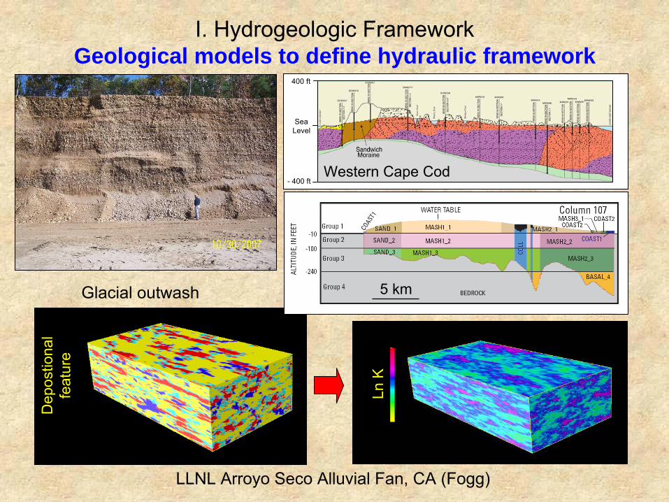
I. Hydrogeologic
Framework Geological models to define hydraulic framework
IV. Future Directions Incorporation of uncertainty in simulation and prediction
Western Cape Cod
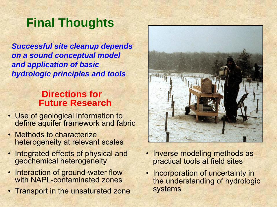
Final Thoughts
Directions for Future Research
•
Use of geological information to define aquifer framework and fabric
•
Methods to characterize heterogeneity at relevant scales
•
Integrated effects of physical and geochemical heterogeneity
•
Interaction of ground-water flow with NAPL-contaminated zones
•
Transport in the unsaturated zone
Successful site cleanup depends on a sound conceptual model and application of basic hydrologic principles and tools
•
Inverse modeling methods as practical tools at field sites
•
Incorporation of uncertainty in the understanding of hydrologic systems
Slide Item Sources of information and images 2 MADE site, MS
NAWC site, NJ Circular 1224
Zheng, Chunmiao, 2008, Understanding solute transport in extremely heterogeneous porous media—Lessons learned from 25 years of research at the MADE site—2009 Birdsall-Dreiss Distinguished Lecturer, Geological Society of America, Hydrogeology Division: GSA Today, v. 18, no. 10, p. 14 [ftp://rock.geosociety.org/pub/GSAToday/gt0810.pdf]
U.S. Geological Survey, 2009, Geochemical and microbiological processes that
affect migration and natural attenuation of chlorinated solvents in fractured sedimentary rock—Naval Air Warfare Center (NAWC) Research Site, West Trenton, NJ: Accessed online December 10, 2009, at http://nj.usgs.gov/nawc/index.htm
ground-water vulnerability to contamination: Providing scientifically defensible information for decision makers: U.S. Geological Survey Circular 1224, 33 p. [http://pubs.usgs.gov/circ/2002/circ1224/]
3 Amargosa Desert site, NV Laurel Bay, SC
U.S. Geological Survey, 2009, Amargosa Desert research site: Accessed online December 10, 2009, at http://nevada.usgs.gov/adrs/
U.S. Geological Survey, 2009, Oxygenated fuel -- Laurel Bay, South Carolina site:
Accessed online December 10, 2009, at http://toxics.usgs.gov/sites/laurel_bay/laurel_page.html
4 Geologic framework, Cape Cod, MA
Masterson, J.P., Stone, B.D., Walter, D.A., and Savoie, Jennifer, 1997, Hydrogeologic framework of western Cape Cod, Massachusetts: U. S. Geological Survey Hydrologic-Investigations Atlas HA 741, 1 plate.
Slide Item Sources of information and images 5 Geological models,
Cape Cod, MA LLNL Arroyo Seco alluvial fan, CA
Masterson, J.P., Stone, B.D., Walter, D.A., and Savoie, Jennifer, 1997, Hydrogeologic framework of western Cape Cod, Massachusetts: U. S. Geological Survey Hydrologic-Investigations Atlas HA 741, 1 plate.
Walter, D.A., and LeBlanc, D.R., 2008, Use of inverse modeling methods to
improve ground-water-modeling calibration and evaluate model-prediction uncertainty, Camp Edwards, Cape Cod, Massachusetts: U.S. Geological Survey Scientific Investigations Report 2007-5257, 57 p. [http://pubs.usgs.gov/sir/2007/5257/]
Fogg, G.E., 2002, A geologic approach to simulation of subsurface hydrology—
2002 Birdsall-Dreiss Distinguished Lecturer, Geological Society of America, Hydrogeology Division: GSA Today, v.18, no. 10, p. 14 [ftp://rock.geosociety.org/pub/GSAToday/gt0810.pdf]
Fogg, G.E., Carle, S.F., and Green, Christopher, 2000, Connected-network
paradigm for the alluvial aquifer system, in Zhang, Dongxiao, and Winter, C.L., eds., Theory, modeling, and field investigation in hydrogeology—A special volume in honor of Shlomo P. Neuman’s 60th birthday: Boulder, CO, Geological Society of America, Special Paper 348, p. 25-42.
Fogg, G.E., Noyes, C.D., and Carle, S.F., 1998, Geologically based model of
heterogeneous hydraulic conductivity in an alluvial setting: Hydrogeology Journal, v. 6, no. 1, p. 131-143.
U.S. Geological Survey, 2009, Horizontal-to-vertical spectral ratio seismic method technology demonstration and evaluation project: Accessed online December 10, 2009, at http://water.usgs.gov/ogw/bgas/hvseismic/
U.S. Geological Survey, 2009, Amargosa Desert research site: Accessed online
December 10, 2009, at http://nevada.usgs.gov/adrs/
7 Inverse modeling Cape Cod, MA
Walter, D.A., and LeBlanc, D.R., 2008, Use of inverse modeling methods to improve ground-water-modeling calibration and evaluate model-prediction uncertainty, Camp Edwards, Cape Cod, Massachusetts: U.S. Geological Survey Scientific Investigations Report 2007-5257, 57 p. [http://pubs.usgs.gov/sir/2007/5257/]
Slide Item Sources of information and images 8 Norman Landfill, OK U.S. Geological Survey, 2009, Biogeochemical and geohydrologic processes in a
landfill-impacted alluvial aquifer, Norman, Oklahoma: Accessed online December 10, 2009, at http://ok.water.usgs.gov/projects/norlan/
9 Defining groundwater flow paths J-3 Range plume, Cape Cod, MA
LeBlanc, D.R., Massey, A.J., Cochrane, J.J., King, J.H., and Smith, K.P., 2008, Distribution and migration of ordnance-related compounds and oxygen and hydrogen stable isotopes in ground water near Snake Pond, Sandwich, Massachusetts, 2001-2006: U.S. Geological Survey Scientific Investigations Report 2008-5052, 19 p. [http://pubs.usgs.gov/sir/2008/5052/]
10 Aberdeen Proving Grounds, MD Cape Cod, MA
Majcher, E.H., Phelan, D.J., Lorah, M.M., and McGinty, A.L., 2007, Characterization of preferential ground-water seepage from a chlorinated hydrocarbon-contaminated aquifer to West Branch Canal Creek, Aberdeen Proving Ground, Maryland, 2002–04: U.S. Geological Survey Scientific Investigations Report 2006–5233, 191 p. [http://pubs.usgs.gov/sir/2006/5233/].
U.S. Geological Survey, 2009, Fiber-optic distributed temperature sensing
technology demonstration and evaluation project: Accessed online December 10, 2009, at http://water.usgs.gov/ogw/bgas/fiber-optics/
11 Flow patterns and discharge Cape Cod, MA
Savoie, J.G., LeBlanc, D.R., Blackwood, D.S., McCobb, T.D., Rendigs, R.R., and Clifford, Scott, 2000, Delineation of discharge areas of two contaminant plumes by use of diffusion samplers, Johns Pond, Cape Cod, Massachusetts, 1998: U.S. Geological Survey Water-Resources Investigations Report WRIR 00-4017, 30 p.
12 Cass Lake, MN Herkelrath, W.N., Delin, G.N., and Cozzarelli, I.M., 2008, Using peristaltic bailing to obtain ground water samples in push probe profiling of a subsurface BTEX plume: Boulder, CO, Geological Society of America Abstracts with Programs, 2088 Annual Meeting, v. 40, no. 6, p. 343 [http://gsa.confex.com/gsa/2008AM/ finalprogram/abstract_148335.htm]
U.S. Geological Survey, 2009, Cass Lake crude-oil spill: Accessed online
December 28, 2009, at http://mn.water.usgs.gov/projects/ description/8607CXW.html
13 Bemidji site, MN U.S. Geological Survey, 2009, Bemidji crude-oil research project: Accessed online December 10, 2009, at http://mn.water.usgs.gov/projects/bemidji/index.html
Slide Item Sources of information and images 14 Geophysical methods and heterogeneity
Cape Cod, MA Singha, Kamini, and Gorelick, S.M., 2005, Saline tracer visualized with three-
dimensional electrical resistivity tomography—Field-scale spatial moment analysis: Water Resources Research, v. 41, W05023, 17 p. [doi:10.1029/2004WR0034600].
Singha, Kamini, and Gorelick, S.M., 2006, Hydrogeophysical tracking of three-
dimensional tracer migration—The concept and application of apparent petrophysical relations: Water Resources Research, v. 42, W06422 [doi:10.1029/2005WR004568].
U.S. Geological Survey, 2009, Mapping aquifer heterogeneity-- Integrated analysis
of geophysical and hydraulic data at the Massachusetts Military Reservation, Cape Cod, Massachusetts: Accessed online December 11, 2009, at http://water.usgs.gov/ogw/bgas/toxics/mmr_ert.html
15 Macrodispersion and heterogeneity Cape Cod, MA
LeBlanc, D.R., Garabedian, S.P., Hess, K.M., Gelhar, L.W., Quadri, R.D., Stollenwerk, K.G., and Wood, W.W., 1991, Large-scale natural-gradient tracer test in sand and gravel, Cape Cod, Massachusetts: 1. Experimental design and observed tracer movement: Water Resources Research, v. 27, no. 5, p. 895-910.
test in sand and gravel, Cape Cod, Massachusetts: 3.Hydraulic-conductivity variability and calculated macrodispersivities: Water Resources Research, v. 28, no. 8, p. 2011-2027.
test in sand and gravel, Cape Cod, Massachusetts: 3.Hydraulic-conductivity variability and calculated macrodispersivities: Water Resources Research, v. 28, no. 8, p. 2011-2027.
U.S. Geological Survey, 2009, Cape Cod Toxic Substances Hydrology research
site: Accessed online December 10, 2009, at http://ma.water.usgs.gov/CapeCodToxics/
Slide Item Sources of information and images 16 MADE site, MS Zheng, Chunmiao, and Gorelick, S.M., Analysis of solute transport in flow fields
influenced by preferential flowpaths at the decimeter scale: Ground Water, v. 41, no. 2, p. 142-155.
Harvey, C.F., and Gorelick, S.M., 2000, Rate-limited mass transfer or
macrodispersion: Which dominates plume evolution at the Macrodispersion Experiment (MADE) site?: Water Resources Research, v. 36, no. 3, p. 637–650.
C.P., and Stauffer, T.B., 1993, Database for the second macrodispersion experiment (MADE-2): California, Electric Power Research Institute, TR-102072.
17 Angus PCE plume, ON Conant Jr., B., Cherry, J.A., and Gillham, R.W., 2004, A PCE groundwater plume discharging to a river—Influence of the streambed and near-river zone on contaminant distributions: Journal of Contaminant Hydrology, v. 73, no. 1-4, p. 238-279.
Conant Jr., B., 2004, Delineating and quantifying ground-water discharge zones using streambed temperatures: Ground Water, v. 42, no. 2, p. 243-257.
18 Uncertainty in simulation and prediction Cape Cod, MA
Walter, D.A., and LeBlanc, D.R., 2008, Use of inverse modeling methods to improve ground-water-modeling calibration and evaluate model-prediction uncertainty, Camp Edwards, Cape Cod, Massachusetts: U.S. Geological Survey Scientific Investigations Report 2007-5257, 57 p. [http://pubs.usgs.gov/sir/2007/5257/]