15
VIRGINIA MINES INC. FCI PROJECT Au-Cu-Zn-Ag James Bay Area, Quebec NTS 33G/08, 33G/09, 33H/05 and 33H/12
VIRGINIA MINES INC.
FCI PROJECTAu-Cu-Zn-Ag
James Bay Area, QuebecNTS 33G/08, 33G/09, 33H/05 and 33H/12
FCI PROJECTSUMMARY REPORT
1. Location And Access
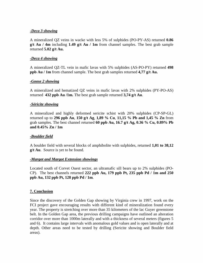
The FCI project is located approximately 485 Km north-east of the town of Matagami, inthe James Bay area, province of Quebec (figure 1). The project is less than 12 Km fromthe Transtaiga all-weather road (figure 2). The property is accessible by helicopter andfloatplane readily available at LG-4, 65 km to the NW on the Transtaiga road. In winterthe project can be reach with tractor road. The FCI project, 100% owned by VirginiaMines Inc., is composed of 412 map designated claims (figure 3) for a total area of 211Km2.
2. Regional Geology
Geological units of the FCI area belong to the Archean greenstone belt of Lac Guyer(2749Ma). This belt is part of the La Grande sub-Province of the Superior Province. Thearea is an assemblage of volcano-sedimentary rocks sitting on Archean tonalitic gneissbasement (3.0Ga). Metamorphism ranges from upper greenschist to amphibolite level.About 100 Km to the west, the Guyer belt hosts the Virginia’s Poste Lemoyne project.This property is known for its numerous gold occurences including the Orphée gold Zone(100,000 oz Au).
3. Property Geology
Mafic volcanic are the principal units followed by ultramafic rocks and felsic lavas. Thesedimentary units are dominated by iron formations and to a lesser extend, by clasticrocks. Diabase and felsic dykes are numerous in the belt. These rocks are cut bynumerous shear zones.
4. Previous Work
Almost no work was done on the property area before Virginia Mines. Tyrones Minesdid prospection work for base metal in 1959. Regional mapping was done by the GSC inlate ‘50s and by Quebec Government in 1977.
5. Virginia’s Work Programs
Summer & Fall 1997
-Reconnaissance mapping & prospecting with 211 rock samples, 41 till samples, 56 soilsamples.
In 1998
-Line cutting,
-Geophysical survey (MAG-IP),-Reconnaissance mapping & prospecting with 411 rock samples.
In 1999
-Reconnaissance mapping & prospecting with 309 rock samples.
Spring to summer 2000
-60 km of line cutting,-Geophysical survey (MAG-IP),-Reconnaissance mapping & prospecting with 462 rock samples.
Winter 2001
-Drilling campaign with 6 holes (675m).
Summer 2005 and 2006
-Reconnaissance mapping & prospecting,-Limited soil survey,-1591 km airborne Mag survey over all the property,-33 km of MAG–EM on Séricite showing area,-1304 rock samples, 2838 soil samples and 10 till samples.
Winter & summer 2007
-Drilling campaign with 9 holes (1448m),-Reconnaissance mapping & prospecting with 236 rock samples on Golden Gap area.
Fall 2009
-Reconnaissance mapping and prospecting with 538 rocks samples.-Limited till survey (13 samples)
Winter 2010
-Drilling campaign of eleven holes for 3035m in the Golden Gap area.
6. Showing and Mineralization
Since 1997, many gold showings were discovered (figure 4) and few of them weredrilled.
-Golden Gap showing area
The main showing of FCI property is associated with a deformation zone. Mafic volcanicrocks are highly deformed and mineralized in sulphides (PO-PY-AS). Mineralization isassociated with strong silicification and moderate biotite alteration.
Grab samples returned 3.1 to 108.9 g/t Au. The best surface channel samples returned14.3 g/t Au / 2m. In 2001 a drill hole returned 1.62 g/t Au / 2.5m(IL-01-01). Best resultfrom the 2007 drilling program is 10.48 g/t Au / 7m (FCI-07-003).
The 2010 drilling campaign yielded many large gold bearing intervals that delineate analteration corridor of more than 1000m in length and a thickness of several meters(figures 5 and 6). It is open laterally and at depth. The easternmost drill hole in thiscorridor contains visible gold and has returned the best 2010 result with 14.15 g/t over0.5m (FCI-10-010) (photo 1) .
-Félicie showing
A mineralized QFP dyke with sulphides (GL-CP-SP-PY-PO-BN-Cu) returned in a grabsampling 5,54 g/t Au, >100 g/t Ag, 1,86 % Cu, 1,56 % Pb, 4,94 % Zn. Channelsample returned up to 0,99 g/t Au.
-Golden East 1 showing
A wacke injected with quartz veins and sulphides (PO-PY-AS) returned 3,43 to 21,21 g/tAu in grab samples. Best channel returned 0,84 g/t Au / 1m. A drill hole (IL-01-04)returned two intersections: 360 ppb Au / 1m and 456 ppb Au / 1m.
-Golden East 2 showing
35 meters east from Golden East 1 a wacke with quartz-tourmaline veins and sulphides(PO-PY-AS-CP) returned 1,84 g/t Au / 1m and 0,77 g/t Au / 1m.
-Deca 1 showing
A mineralized QZ-TL veins in mafic lavas with 15% sulphides (AS-PO-PY) returned1,19 g/t Au / 2 m, 1,91 g/t Au / 5m and 3,4 g/t Au / 2m from surface channels samples.The best grab sample returned 6,91 g/t Au. A drill hole (IL-01-05), returned anintersection of 1,10 g/t Au / 1m.
-Deca 2 showing
A mineralized QZ veins in wacke with less 2% of sulphides (PO-PY-AS) returned 1,29g/t Au / 1 m and 1,84 g/t Au / 1m from channel samples.
-Deca 3 showing
A mineralized QZ veins in wacke with less 5% of sulphides (PO-PY-AS) returned 0.86g/t Au / 4m including 1.49 g/t Au / 1m from channel samples. The best grab samplereturned 5.02 g/t Au.
-Deca 4 showing
A mineralized QZ-TL vein in mafic lavas with 5% sulphides (AS-PO-PY) returned 498ppb Au / 1m from channel sample. The best grab samples returned 4,77 g/t Au.
-Goose 2 showing
A mineralized and hematized QZ veins in mafic lavas with 2% sulphides (PY-PO-AS)returned 432 ppb Au /1m. The best grab sample returned 3,74 g/t Au.
-Séricite showing
A mineralized and highly deformed sericite schist with 20% sulphides (CP-SP-GL)returned up to 296 ppb Au, 150 g/t Ag, 1,89 % Cu, 11,15 % Pb and 1,45 % Zn fromgrab samples. The best channel returned 60 ppb Au, 16.7 g/t Ag, 0.36 % Cu, 0.89% Pband 0.45% Zn / 1m
-Boulder field
A boulder field with several blocks of amphibolite with sulphides, returned 1,01 to 38,12g/t Au. Source is yet to be found.
-Margot and Margot Extension showings
Located south of Corvet Ouest sector, an ultramafic sill bears up to 2% sulphides (PO-CP). The best channels returned 222 ppb Au, 179 ppb Pt, 235 ppb Pd / 1m and 250ppb Au, 132 ppb Pt, 128 ppb Pd / 1m.
7. Conclusion
Since the discovery of the Golden Gap showing by Virginia crew in 1997, work on theFCI project gave encouraging results with different kind of mineralization found everyyear. The property is stretching over more than 35 kilometers of the lac Guyer greenstonebelt. In the Golden Gap area, the previous drilling campaigns have outlined an alterationcorridor over more than 1000m laterally and with a thickness of several meters (figures 5and 6). It contains large intervals with anomalous gold values and is open laterally and atdepth. Other areas need to be tested by drilling (Sericite showing and Boulder fieldareas).

Work proposal:
-Additional drilling in the Golden Gap area, Boulder field area and Sericite showing.
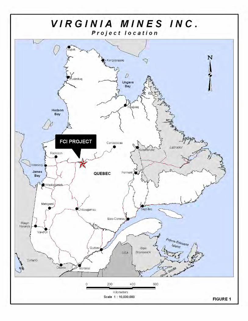
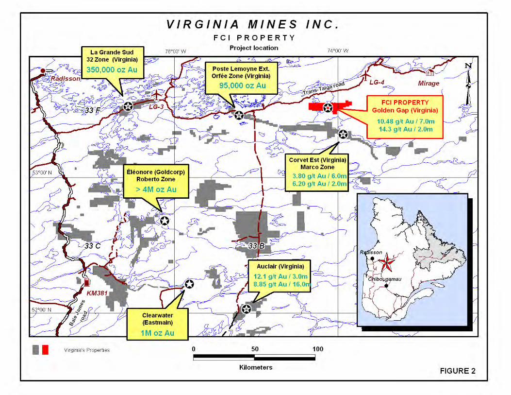
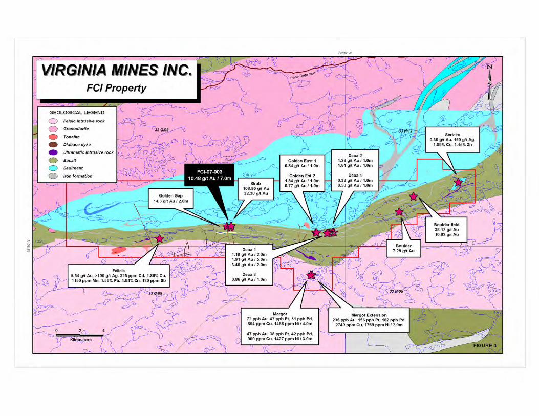
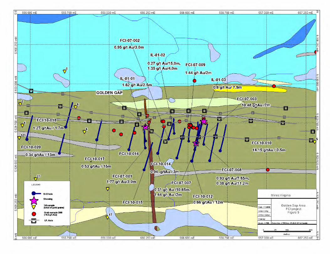
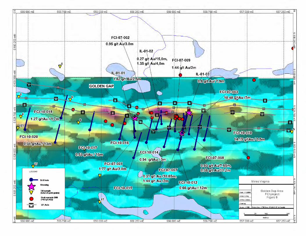
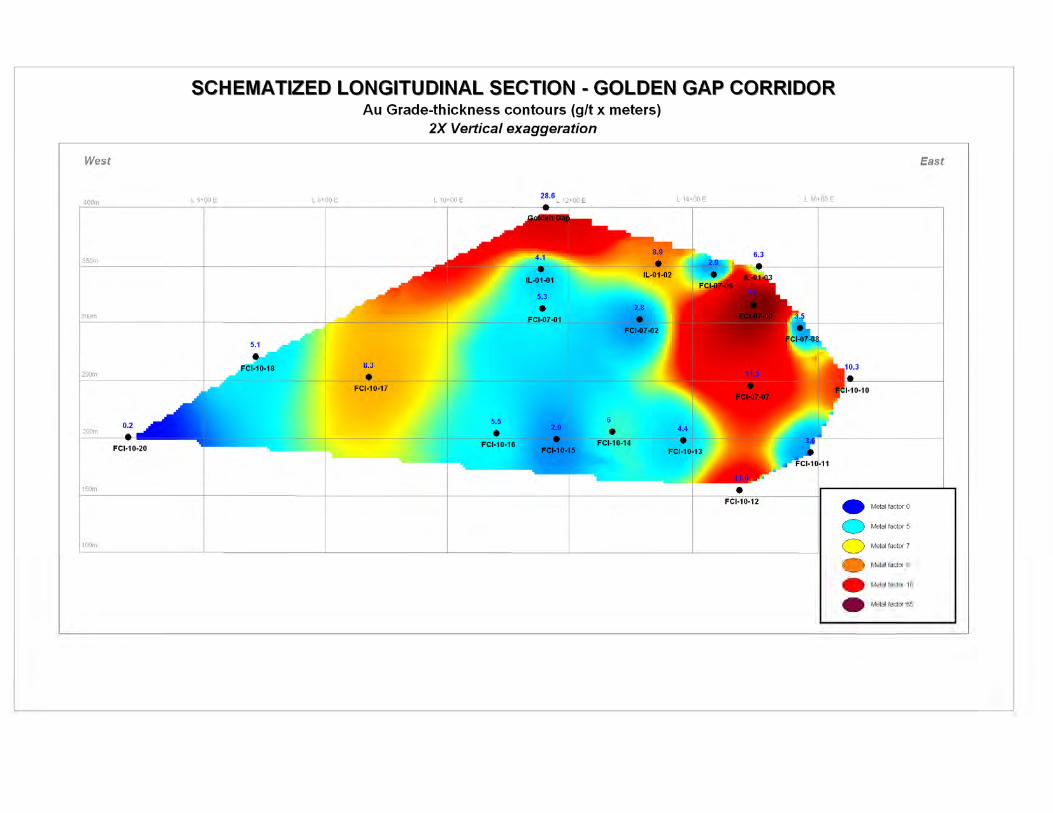
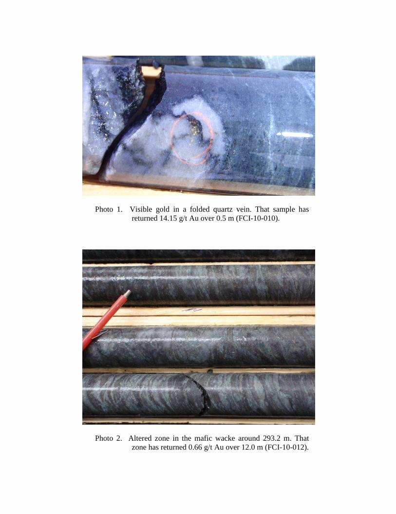
Photo 1. Visible gold in a folded quartz vein. That sample hasreturned 14.15 g/t Au over 0.5 m (FCI-10-010).
Photo 2. Altered zone in the mafic wacke around 293.2 m. Thatzone has returned 0.66 g/t Au over 12.0 m (FCI-10-012).
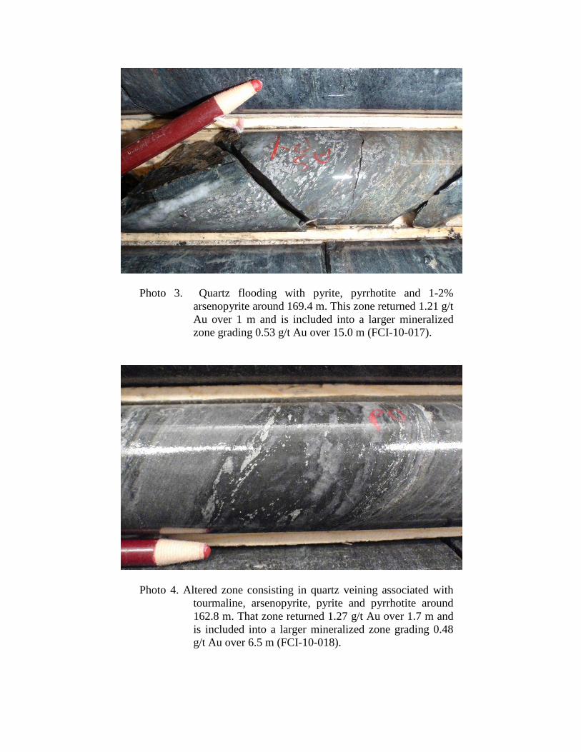
Photo 3. Quartz flooding with pyrite, pyrrhotite and 1-2%arsenopyrite around 169.4 m. This zone returned 1.21 g/tAu over 1 m and is included into a larger mineralizedzone grading 0.53 g/t Au over 15.0 m (FCI-10-017).
Photo 4. Altered zone consisting in quartz veining associated withtourmaline, arsenopyrite, pyrite and pyrrhotite around162.8 m. That zone returned 1.27 g/t Au over 1.7 m andis included into a larger mineralized zone grading 0.48g/t Au over 6.5 m (FCI-10-018).


