Feasibility studies of two small-medium multipurpose storage reservoirs of Norera and Borenga in Kenya and Tanzania respectively in the Mara River Basin Country Kenya-Tanzania Name of client Nile Basin Initiative / Nile Equatorial Lakes Subsidiary Action Program Dates (start/end) 2013-2014 The specific objectives of the Consultancy Services Contract were: Water resources analysis of the transboundary Mara catchment, incl. hydrological analysis and sediment modeling to estimate inflows, soil erosion, reservoir and sediment yields at the proposed dam sites. Analysis for water resources demands for various purposes such as irrigation, domestic and livestock water supplies, and environmental flows requirements projected to year 2035. A reservoir simulation model for each dam site to ensure that different combinations of multipurpose uses and project scenarios can be studied in order to arrive at the optimum solution. Preliminary designs for the two dams. Major features of design consideration include: foundation treatment, abutment stability, seepage conditions, stability of slopes adjacent to control structure, approach channels and stilling basins, stability of reservoir slopes, and ability of the reservoir to retain the stored water. For this purpose topographical surveying and geological, geophysical and geotechnical investigations are performed. Preliminary Environmental and Social Impact Assessments (ESIA), compliant with international standards and environmental and social requirements of National Environmental Management Authority (NEMA), Kenya, and the National Environmental Management Council (NEMC), Tanzania, as well as with the World Bank’s safeguard/policies. A preliminary Environmental and Social Impact analysis includes a preliminary Resettlement Action Plan (RAP) report and Public Participation Strategy report. Institutional analysis aiding in the definition of suitable institutional setups and arrangements for project implementation including mechanisms to implement nationally while maintaining transboundary dimensions. Both financial and economic analyses of the projects, including costs for implementing the Environmental and Social Management Plan and Resettlement Action Plan. The principle output was a feasibility study report with the following outputs as annexure: (i) Field Investigations report (topographical, geotechnical, and geological analyses); (ii) Multipurpose reservoirs analysis report (hydrology, demand, reservoirs and water allocation studies); (iii) Preliminary designs (iv) Financial and Economic Analysis and (v) Preliminary Environmental and Social Assessment report for both project areas. Mara River Basin Catchment
Transcript
Feasibil ity studies of two small-medium multipurpose storage reservoirs of Norera
and Borenga in Kenya and Tanzania respectively in the Mara River Basin Country Kenya-Tanzania Name of client Nile Basin Initiative / Nile Equatorial Lakes Subsidiary Action Program Dates (start/end) 2013-2014 The specific objectives of the Consultancy Services Contract were: Water resources analysis of the transboundary Mara catchment, incl. hydrological analysis and sediment
modeling to estimate inflows, soil erosion, reservoir and sediment yields at the proposed dam sites. Analysis for water resources demands for various purposes such as irrigation, domestic and livestock
water supplies, and environmental flows requirements projected to year 2035. A reservoir simulation model for each dam site to ensure that different combinations of multipurpose uses
and project scenarios can be studied in order to arrive at the optimum solution. Preliminary designs for the two dams. Major features of design consideration include: foundation
treatment, abutment stability, seepage conditions, stability of slopes adjacent to control structure, approach channels and stilling basins, stability of reservoir slopes, and ability of the reservoir to retain the stored water. For this purpose topographical surveying and geological, geophysical and geotechnical investigations are performed.
Preliminary Environmental and Social Impact Assessments (ESIA), compliant with international standards and environmental and social requirements of National Environmental Management Authority (NEMA), Kenya, and the National Environmental Management Council (NEMC), Tanzania, as well as with the World Bank’s safeguard/policies. A preliminary Environmental and Social Impact analysis includes a preliminary Resettlement Action Plan (RAP) report and Public Participation Strategy report.
Institutional analysis aiding in the definition of suitable institutional setups and arrangements for project implementation including mechanisms to implement nationally while maintaining transboundary dimensions.
Both financial and economic analyses of the projects, including costs for implementing the Environmental and Social Management Plan and Resettlement Action Plan.
The principle output was a feasibility study report with the following outputs as annexure: (i) Field Investigations report (topographical, geotechnical, and geological analyses); (ii) Multipurpose reservoirs analysis report (hydrology, demand, reservoirs and water allocation studies); (iii) Preliminary designs (iv) Financial and Economic Analysis and (v) Preliminary Environmental and Social Assessment report for both project areas.
Mara River Basin Catchment
Feasibil ity studies of two small-medium multipurpose storage reservoirs of Norera
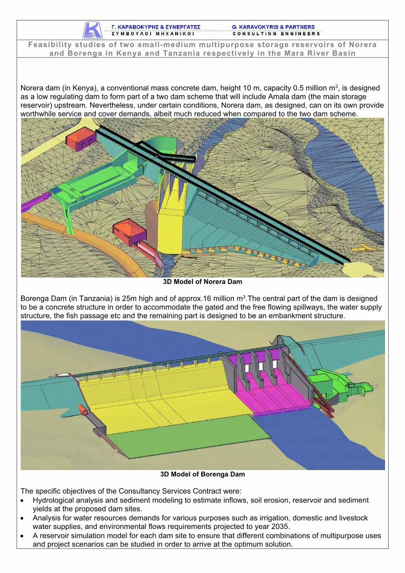
and Borenga in Kenya and Tanzania respectively in the Mara River Basin Norera dam (in Kenya), a conventional mass concrete dam, height 10 m, capacity 0.5 million m3, is designed as a low regulating dam to form part of a two dam scheme that will include Amala dam (the main storage reservoir) upstream. Nevertheless, under certain conditions, Norera dam, as designed, can on its own provide worthwhile service and cover demands, albeit much reduced when compared to the two dam scheme.
3D Model of Norera Dam
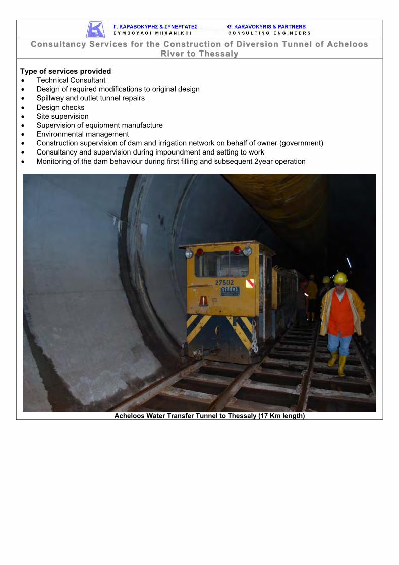
Borenga Dam (in Tanzania) is 25m high and of approx.16 million m3.The central part of the dam is designed to be a concrete structure in order to accommodate the gated and the free flowing spillways, the water supply structure, the fish passage etc and the remaining part is designed to be an embankment structure.
3D Model of Borenga Dam The specific objectives of the Consultancy Services Contract were: Hydrological analysis and sediment modeling to estimate inflows, soil erosion, reservoir and sediment
yields at the proposed dam sites. Analysis for water resources demands for various purposes such as irrigation, domestic and livestock
water supplies, and environmental flows requirements projected to year 2035. A reservoir simulation model for each dam site to ensure that different combinations of multipurpose uses
and project scenarios can be studied in order to arrive at the optimum solution.
Feasibil ity studies of two small-medium multipurpose storage reservoirs of Norera
and Borenga in Kenya and Tanzania respectively in the Mara River Basin Preliminary designs for the two dams. Major features of design consideration include: foundation
treatment, abutment stability, seepage conditions, stability of slopes adjacent to control structure, approach channels and stilling basins, stability of reservoir slopes, and ability of the reservoir to retain the stored water. For this purpose topographical surveying and geological, geophysical and geotechnical investigations are performed.
Preliminary Environmental and Social Impact Assessments (ESIA), compliant with international standards and environmental and social requirements of National Environmental Management Authority (NEMA), Kenya, and the National Environmental Management Council (NEMC), Tanzania, as well as with the World Bank’s safeguard/policies. A preliminary Environmental and Social Impact analysis includes a preliminary Resettlement Action Plan (RAP) report and Public Participation Strategy report.
Institutional analysis aiding in the definition of suitable institutional setups and arrangements for project implementation including mechanisms to implement nationally while maintaining transboundary dimensions.
Both financial and economic analyses of the projects, including costs for implementing the Environmental and Social Management Plan and Resettlement Action Plan.
The principle output was a feasibility study report with the following outputs as annexure: (i) Field Investigations report (topographical, geotechnical, and geological analyses); (ii) Multipurpose reservoirs analysis report (hydrology, demand, reservoirs and water allocation studies); (iii) Preliminary designs (iv) Financial and Economic Analysis and (v) Preliminary Environmental and Social Assessment report for both project areas.
SSii ttee IInnvveesstt iiggaatt iioonnss,, DDeettaa ii lleedd DDeessiiggnn aanndd BBiiddddiinngg DDooccuummeennttss ffoorr LLuuddaa YYaannaa DDaamm Country Bulgaria Name of client Ministry of Regional Development and Public Works Dates (start/end) 2012-2015 Design for the completion of Luda Yana Dam (embankment dam with clay core, 50 m high) for the water supply of 45,000 people in the town of Panajurishte and the surrounding villages. Luda Yana dam is located at about 2 km northeast from the town of Panagyurishte, on Luda Yana river, immediately downstream of the confluence of Stara River and Muleiska River. The design on which the construction work started was prepared by the Institute of design and Investigation “Vodproekt” in 1982 and 1984. Luda Yana water supply system of Panagyurishte town is designed for provision of normal water supply of the town of Panagyurishte and the following villages: Oborishte, Poibrene, Popintsi, Bania, Buta, Levski, Elshitsa, Radka mine, “Optikoelektron” and “Asarel” sites of Panagyurishte community, and 5 more villages in Pazardzhik and Strelcha communities. There is a technical possibility also for water supply of Lesichovo community. Calculations were made with the perspective of providing 45 000 inhabitants with potable water by the year 2055. At present the area is supplied with water from river terraces of Maritsa River, near Zlokuchene village, via 45 km long pipeline constructed 20 years ago. The facility is obsolete, frequent breakdowns create uncertainty and lead to water-supply restrictions. The main facilities of Luda Yana Dam and Reservoir scheme are: dam, water intake tower, diversion tunnel, bottom outlet, spillway, potable water treatment plant (PWTP). Luda Yana reservoir is a state public property and it is governed by the Ministry of Regional Development and Public Works (MRDPW). The future managing company of the dam is going to be “Water and Sewerage – P” Ltd (W&S – P Ltd), Panagyurishte town. The dam was designed as embankment type, built from local materials. The watertight element is a clay core founded in its central part on top of the grouting gallery and into foundation slab in the banks. On both sides of the core are the dam shoulders of gravel fill which are connected to the clay by transition zones. The grouting gallery is entirely excavated into the rock foundation. From the grouting gallery was implemented a grout curtain in the central part. In the banks, a concrete slab is cast in the bedrock used for implementation of the grout curtain and for connection with the core’s foundation. At the time of contract signing 70% of the dam was constructed (70% of the entire fill), the excavations for the spillway and the chute were completed, the stone cover (armor) on the upstream side was partially placed, part of the control and instrumentation system was installed - up to the height of the fill; stone quarry, clay quarry and humus landfill sites were developed. The dam wais constructed up to 30 m height and the civil works had been suspended for nine years. The main facilities of Luda Yana Dam and Reservoir scheme are: dam, water intake tower, diversion tunnel, bottom outlet, Mexican-type spillway, potable water treatment plant with a capacity of 25,000 cubic meters per day (PWTP), Pumping station and pipe downstream of the dam feeding the PWTP with water from the reservoir, HPP, Service building for the operation of the dam and its appurtenant structures, water pipes to towns/villages, Service infrastructure, including power supply lines and equipment, site sewerage and site communications. The design and bidding documents have been completed and approved. Designer's construction supervision is to be carried out.
Country Greece Name of client Ministry for the Environment, Planning and Public Works Origin of funding European Commission - CF Dates (start/end) 1996-2013
Τhe city of Patras (third largest city in Greece, with a population of 200,000) has an inadequate water supply both quantity and quality wise. As part of the project, alternative water supply source configurations were examined and a final solution was arrived at and dimensioned with the help of a water management model developed for the project.
The final scheme included:
a low concrete diversion dam on Piros river
a 77 m high storage dam on Parapiros river
a 10.5 km long 1000-1100mm diameter diversion pipeline
a diversion tunnel with diameter 5.25 m
a water treatment plant with capacity of 0.5 m3/s
a bulk water transmission pipeline to Patras and the adjacent coastal area (56 Km total length, steel & HDPE, 1100-1200 mm diameter)
a water supply network to the adjacent coastal area (40 Km total length)
the relevant diversion roadworks Type of services provided
Hydrology, Formulation of Water management model, Evaluation of Alternatives,
Site Investigation, Feasibility Study,
Detailed Design and Tender Document preparation,
Construction Supervision on behalf of the owner (government)
The construction is at a final stage. Total construction budget of the works is 290 million USD.
Country Greece Name of client Ministry for the Environment, Planning and Public Works, GR.IT.AU Evinos J/V Origin of funding European Commission - CF Dates (start/end) 1990-2000 The Evinos project, which consists of a dam on river Evinos and a conveyance tunnel between Evinos and the river Mornos, represents the second stage of the Greater Athens water supply scheme. Athens had been supplied with water from a reservoir on river Mornos through a 186 Km long aqueduct. The Evinos project allows the diversion of water from the adjacent basin of Evinos to the reservoir on Mornos.
Aghios Dimitrios embankment dam (127 m high) Reservoir volume of 140 million m3 Spillway capacity 2300 m3/s 900 m diversion tunnel Evinos-Mornos water transfer tunnel (length 29.4 Km and internal
diameter 3.5 m with maximum capacity of 30 m3/s) RCC river intake 10 m high 3 Km 2000 mm diameter steel pipeline Services provided: Feasibility Study for the enhancement of Athens water supply to
cover needs up to 2030 Feasibility Study, Preliminary Design, Detailed Tender Design
and Tender Documents for the dam Consultancy Services to the Contractor for the dam and the
tunnel during construction and operation Enhanced Final Design for the safety of the whole of the works Construction supervision, quality control, monitoring of
instrumentation and design adaptations Monitoring and reporting of the dam behaviour through first
impoundment and following three years of operation
RRiivveerr ttoo TThheessssaallyy Country Greece Name of client Ministry for the Environment, Planning and Public Works Origin of funding Greek State Dates (start/end) 1998-2004 Technical Consultant to the Ministry of Public Works for: The completion of Smokovo dam (103 m high), impoundment of reservoir (240 million m³), implementation
of the environmental impact assessment forms as well as the environmental operational management of the reservoir, completion of water transfer tunnel (3 m dia, 4.2 km) and outlet works and construction and setting to work of irrigation distribution pressure pipe system. The reservoir has now been fully impounded and all safety features operated and tested.
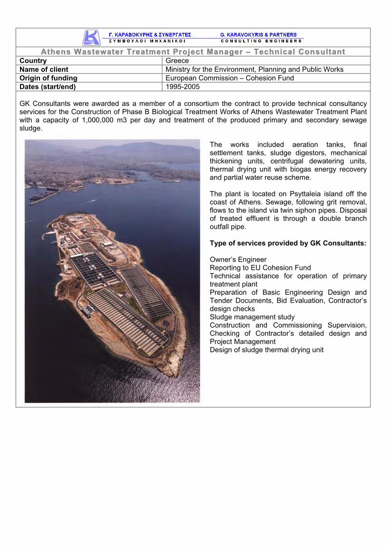
The completion of Acheloos diversion tunnel (7 m dia, 17 km) as well as inlet, outlet and control works for the provision of 600 million m³/annum of irrigation water.
RRiivveerr ttoo TThheessssaallyy Type of services provided Technical Consultant Design of required modifications to original design Spillway and outlet tunnel repairs Design checks Site supervision Supervision of equipment manufacture Environmental management Construction supervision of dam and irrigation network on behalf of owner (government) Consultancy and supervision during impoundment and setting to work Monitoring of the dam behaviour during first filling and subsequent 2year operation
Acheloos Water Transfer Tunnel to Thessaly (17 Km length)
DDooccuummeennttss aanndd SSuuppeerrvviiss iioonn ooff CCoonnsstt rruucctt iioonn ooff SSoolleeaa DDaamm iinn CCyypprruuss Country Cyprus Name of client Ministry of Agriculture, Water Resources and the Environment – Water Development
Department Dates (start/end) 2006-2012 Design and construction supervision of Solea Irrigation Dam in Nicosia Prefecture. The dam will collect Karkotis river water in order to irrigate the neighboring regions. Solea irrigation dam is an earth-filled dam, 53 m high, with reservoir capacity of 4.5 million m³ and its associated works (diversion dam, diversion pipeline, pumping station, irrigation network). Irrigation networks include 8.500 Km of pipelines (ductile iron). The Consultant already finalized the Design Work and prepared the Tender documents, based on which following a Tender Procedure, a Contractor was awarded to undertake the dam’s construction.
Type of services provided Hydrology Geotechnical Design Detailed Design Tender Documents Construction Drawings Dam safety plan development and implementation On-going Construction Supervision of dam and irrigation network on behalf of owner (government)
KKeennyyaa Country Kenya Name of client Kenya Electricity Generating Company Ltd Dates (start/end) 2011-2012
Dams Safety Inspections and Assessment for all dams owned by the Kenya Generating Company (KenGen), including: Dams in the Lower Tana basin (Masinga – 55 m
earthfill/rockfill dam, Kamburu – 56 m rockfill dam, Gitaru – 30 m earthfill/rockfill dam, Kindaruma – 23 m rockfill dam and Kiambere – 110 m earthfill/rockfill dam),
Dams in the Upper Tana basin (Sagana, Mesco, Wanjii, Tana and Ndula),
Turkwel – 150 m arch dam, Sondu, Gogo and Sosiani Dams.
The safety assessments concerned dam safety, that is the safety of the water retaining structures themselves, as well as any appurtenant structures related to the safety of the dams themselves, such as spillways, bottom outlets, etc. Other structures related to water conveyance and power generation not related to the safety of the dams do not form part of the scope of these services. The project included the dewatering and full inspections of Mathioyia Tunnel (Internal Diameter: approx. 3,000mm, Length: 5,200 m) The methodology employed for this project, followed ICOLD practice with particular adherence to ICOLD’s check lists of Bulletin 59 on dam safety (relative bulletins that might be used are No. 60, 82, 87, 93 and 125). Dams
and their appurtenant structures are inspected by highly experienced engineers, based on detailed checklists for (a) the crest area, (b) the downstream slope, (c) the upstream slope, (d) the installed instrumentation, (e) the downstream area, (f) the spillway and (g) the galleries [for seepage, inspection, access, etc] and bottom outlet chambers of each dam. The following theoretical reviews executed by GK Consultants included: (a) storm routing for major reservoirs, (b) stability analysis for major embankments and (c) each dam monitoring and instrumentation. The assessment and recommendations report for each dam made use of all above activities and covered the relevant ICOLD checklist. GK Consultants organized training workshops in Nairobi which included presentation and training on key issues related to dam safety and, finally, presentation of the particular characteristics, safety issues and monitoring demands of the dams.
Inspection of Mathioyia Tunnel (5.2 Km long)
IIddeenntt ii ff ii ccaatt iioonn ooff aa MMuull tt iippuurrppoossee WWaatteerr RReessoouurrcceess MMaannaaggeemmeenntt aanndd DDeevveellooppmmeenntt
PPrroojjeecctt iinn tthhee AAsswwaa BBaassiinn Country Uganda/South Sudan Name of client Nile Basin Initiative (NBI) Dates (start/end) 2012 The NBI awarded the project on February 2012. GK Consultants is the leading firm in this project. The goal of this project is to contribute towards poverty reduction, reversal of environmental degradation and socioeconomic development in the study area. The study area comprises mainly of the basin of river Aswa, a tributary of the Nile. The study area also includes a stretch of the main Nile River (Bahr el Jebel) from Nimule, close to the Ugandan-South Sudan border to Lakki in South Sudan. The project's objective is to identify a Multipurpose Water Resources Management and Development project to improve water, food and energy security; reduce flow variability and flood damage; and contribute towards improved livelihoods without compromising the environment. The identification will follow the basin as the basic hydrological unit for optimal development, from both technical and economic perspectives. Great emphasis was placed in the diagnostic phase in investigating drought vulnerability of rainfed agriculture and livestock production in different parts of the area, including the very water scarce pastoralist Karamojah region. Sustainable rates of groundwater resources exploitation were also investigated. Development projects and plans for mitigation are being designed for agriculture, livestock and aquaculture and the environment, particularly wetlands. For domestic use emphasis is placed on quality and access improvement. The main study output is an identification study report upon which detailed preparation and investment will be based. The specific objectives of the assignment are: to identify potential regional investment options, taking into account their economic, social and
environmental implications as well as cumulative impacts, to investigate the alignment of potential regional investment options with national level priorities and
plans, to prioritize and sequence potential investments, also in light of existing and planned interventions up to
2035 and to prepare an investment project that falls within the National Planning Frameworks of Uganda and
Southern Sudan. In order to achieve these objectives the Consultant executes the following tasks: 1) TASK 1: Diagnostic I Situational analysis. 2) TASK 2: Formulation of Multipurpose Basin Water Resources Development and Management Strategy. 3) TASK 3: Formulation of Multipurpose Basin Water Resources Investment Plan. 4) TASK 4: Formulation of Bankable Investment Study for two lowland rice irrigation schemes, one in Moroto River (7,615 ha) and one in Nimur River (4,005 ha in Uganda and 1,100 ha in Southern Sudan).
Country Rwanda Name of client Ministry of Agriculture and Animal Resources of Rwanda Origin of funding World Bank Dates (start/end) 2011-2012 The Government of Rwanda is pursuing a comprehensive Poverty Reduction program which includes development and implementation of various sustainable development projects. The Land husbandry, Water harvesting and Hillside irrigation (LWH) Project is one of the development initiatives designed under the Ministry of Agriculture and Animal Resources (MINAGRI) and partly funded by the World Bank in order to tackle the issues related to food insecurity and rural communities livelihoods income. The project focuses on modernization and commercialization of agriculture for strengthening the economic access of the rural communities to food for consumption and livelihoods improvement. The emphasis of LWH is on broadening and deepening support provided to the rural communities. The Land Husbandry, Water Harvesting and Hillside Irrigation (LWH) Project uses a modified watershed approach to introduce sustainable land husbandry measures for hillside agriculture on selected sites, as well as developing hillside irrigation for sub-sections of each site. The Project envisions the production of high-value (organic) horticultural crops with the strongest marketing potential on irrigated portions of hillsides of the watershed. It is in this regard that the Project will invest in water harvesting infrastructure, including valley dams and irrigation infrastructure on the selected sites. The existing designs are for dams with heights of about 20 meters or less and will inundate on average about 6 hectares each. Water harvesting infrastructure will be developed jointly with the irrigation infrastructure including the water conveyance open-channels and pipes. For this purpose the project conducted detailed feasibility studies and designs in 2008 of the dams and supplemental irrigation infrastructure necessary for hillside irrigation which are to be constructed at four sites (Karongi-12, Karongi-13, Nyanza-23 and Gatsibo-8). The Consultant reviewed, modified and completed the existing design studies, ensured that the construction will meet the international dam safety standards and technical requirements, and prepared complete construction tender documents. They have also completed a feasibility study for using supplementary irrigation as a drought mitigation measure in hillslope agriculture in Rwanda.
Nyanza Dam during first filling (2014)
PPrreeffeeaassiibb ii ll ii ttyy SSttuuddyy,, FFeeaassiibb ii ll ii ttyy SSttuuddyy aanndd DDeettaaii ll DDeessiiggnn ooff MMuull tt iipp llee LLaanndd HHuussbbaannddrryy,, WWaatteerr HHaarrvveesstt iinngg aanndd HHii ll ll ss iiddee II rr rr iiggaatt iioonn SSii tteess ffoorr 33 ,,550000 hhaa iinn
DDii ff ffeerreenntt PPaarr ttss ooff RRwwaannddaa ((LLoott 11)) Country Rwanda Name of client Ministry of Agriculture and Animal Resources of Rwanda Dates (start/end) 2012-2013
Warufu reservoir site (dot. line with the approximate axis alignment)
The Land Husbandry, Water Harvesting and Hillside Irrigation (LWH) Project uses a modified watershed approach to introduce sustainable land husbandry measures for hillside agriculture on selected sites, as well as developing hillside irrigation for subsections of each site. The Project envisions the production of high-value (organic) horticultural crops with the strongest marketing potential on irrigated portions of hillsides of the watershed. It is in this regard that the Project will invest in water harvesting infrastructure, including valley dams and irrigation infrastructure on the selected sites. Water harvesting infrastructure will be developed jointly with the irrigation infrastructure including the water conveyance open-channels and pipes. The overall objective of the study is to undertake a prefeasibility study covering the entire study area and to continue with feasibility studies and detailed designs of multiple land husbandry, dam and hillside irrigation schemes at selected sites with a total net area of 3,500 ha (total gross area of 4,200 ha). Lot 1 sites are located within the boundaries of the Eastern and Northern provinces of Rwanda. The study will aim to produce cost effective and socially acceptable designs. Maps and summary reports of potential sites that have already been identified by the Land Husbandry, Water Harvesting and Hillside Irrigation (LWH) Project will be made available to the Consultant. The study has the following specific objectives: Review previously identified potential sites, identify additional sites if necessary and carry our
reconnaissance surveys, site selection, inception report and prefeasibility study for all sites. Undertake comprehensive feasibility studies including designs, cost estimation, socio-economic and
financial analysis for the selected multiple sites. These studies should comply with international standards and with the World Bank’s safeguard policies.
Undertake detailed design and prepare tended documents for the selected feasible sites. The service covered the fields of: Review of existing designs and studies. Field visits and geotechnical investigations. Prefeasibility studies. Feasibility studies. Detailed design of dams and irrigation networks. Tender documents. Workshops and Training.
PPrreeffeeaassiibb ii ll ii ttyy SSttuuddyy,, FFeeaassiibb ii ll ii ttyy SSttuuddyy aanndd DDeettaaii ll DDeessiiggnn ooff MMuull tt iipp llee LLaanndd HHuussbbaannddrryy,, WWaatteerr HHaarrvveesstt iinngg aanndd HHii ll ll ss iiddee II rr rr iiggaatt iioonn SSii tteess ffoorr 33 ,,550000 hhaa iinn
The project included the feasibility design of Warufu Dam (23 m high, 24 million m3 reservoir) and the feasibility and detailed design of Muyanza Dam (35 m high).
GGrroouupp 11 SSii tteess aanndd PPrreeffeeaassiibbii ll ii ttyy SSttuuddiieess ooff GGrroouupp 22 SSii tteess Country Zambia Name of client Ministry of Agriculture and Livestock of Zambia Dates (start/end) 2012-ongoing
Project’s location Musakashi Sada Project Mwomboshi River
Feasibility study and preliminary design of Mwomboshi Dam and irrigation scheme, Review of PPP potential. Irrigated command areas: Mwomboshi (5000 ha), Lusitu (270 ha), Musakashi (1100 ha). Irrigation systems used: Center pivot, Sprinklers, Low pressure pipe or canal systems feeding furrows. The Government of Zambia has obtained a credit from the International Development Agency (IDA) for a proposed Irrigation Development Support Project (IDSP). The objective of IDSP, which is being executed by the Ministry of Agriculture and Livestock (MAL), is to “increase yields per hectare and value of diverse products marketed by smallholders benefiting from investments in irrigation in selected sites served by the project”. Project interventions will consist of a three-tier system which will be applied, in whole or in part, at each of the irrigation sites to be developed. Tier 1 will be for smallholder farmers who wish to take up irrigated agriculture using mainly family labour, with individually farmed plots of 1 ha or less under surface irrigation, to grow vegetables and other high value crops. Tier 2 will consist of larger plots of between one and five hectares each, for cultivation by emerging small-scale commercial farmers or small groups of farmers, under sprinkler irrigation systems and hired labour to profitably grow mainly field crops. And Tier 3 will consist of large plots of at least 60 ha each under centre-pivot irrigation operated by a private company, or Farm Co., which will initially be jointly owned by the community and a private sector investor but will eventually be wholly owned by the community, probably through a community trust. Apart from operating the Tier 3 farm as a commercial entity the company will also provide support services, such as input supply, extension, credit and marketing to the other two Tiers on a commercial (i.e. profit-making) basis. On the Mwomboshi proposed site there is a Tier 4 consisting entirely of large scale commercial farmers who will share the infrastructure provided under the project – on a full cost recovery basis – thereby permitting economy of scale in the investment. As it was made clear during the pre-proposal meeting the Tier 4 will not be part of the consultancy by means of designing irrigation networks but the water demand for the areas irrigation requirements will be taken into account on the Mwomboshi reservoir water balance. The service covered the fields of: Topographic Surveys. Engineering Geology and Geotechnical Investigations & Studies. Soil and Water Sampling. Social Studies. Agricultural, Economic and Financial Issues. Irrigation Network Design. Dam Design. Ancillary Works Design. Assessment of hazards from extreme floods or dam break.
Country Greece Name of client Ministry for the Environment, Planning and Public Works Origin of funding European Commission – Cohesion Fund Dates (start/end) 1995-2005 GK Consultants were awarded as a member of a consortium the contract to provide technical consultancy services for the Construction of Phase B Biological Treatment Works of Athens Wastewater Treatment Plant with a capacity of 1,000,000 m3 per day and treatment of the produced primary and secondary sewage sludge.
The works included aeration tanks, final settlement tanks, sludge digestors, mechanical thickening units, centrifugal dewatering units, thermal drying unit with biogas energy recovery and partial water reuse scheme. The plant is located on Psyttaleia island off the coast of Athens. Sewage, following grit removal, flows to the island via twin siphon pipes. Disposal of treated effluent is through a double branch outfall pipe. Type of services provided by GK Consultants: Owner’s Engineer Reporting to EU Cohesion Fund Technical assistance for operation of primary treatment plant Preparation of Basic Engineering Design and Tender Documents, Bid Evaluation, Contractor’s design checks Sludge management study Construction and Commissioning Supervision, Checking of Contractor’s detailed design and Project Management Design of sludge thermal drying unit
Country Greece Name of client Public Power Corporation-Renewables S.A. Dates (start/end) 2010-2014 Refurbishment of Louros Hydroelectric Dam and Powerplant (15 MW) at Louros river in the Prefecture of Preveza. Dam height is 23 m, Reservoir capacity is 1 million m3, Spillway capacity 900 m3/s 1200 m tunnel with horseshoe section, 2.7 m diameter, Penstock, Power generators 2x3.8 MW, 1x7.4 MW
Type of services provided: Consulting Services for Tendering of the Refurbishment project: Dam Safety report Civil and M&E design of rehabilitation works
Country Greece Name of client Kavala Prefecture Dates (start/end) 2007-2015
Technical Consultant to Kavala Prefecture for the construction of Marmaras Dam. The dam will be constructed at Marmaras River, 15 km to the south from Akropotamos municipality and 4 km to the north from Loutra Eleftheron region. Dam Technical Characteristics Earthfill dam with clay core 43 m high and 350 m long Reservoir volume 4.300.000 m3 Spillway capacity 450 m3/s Type of services that are provided and included in the scope of contract Technical Consultant (including Consultancy Services during construction) Review of existing studies Design checks Site supervision Supervision of equipment manufacture Environmental management Consultancy and supervision during impoundment and setting to operation. Modifications of construction drawings during the execution of works Currently GK Consultants are responsible for the construction supervision on behalf of owner (government).
Country Kenya Name of client Water Resources Management Authority Dates (start/end) 2010 – 2011 Assessment of rainfall, river flows, sediment loads and other factors relevant to the sustainable management of water resources in the Upper Tana Catchment area. Establishment of physiographical baseline information that can be used for monitoring and evaluating changes in soil erosion, sediment load and reservoir capacity as well as the Catchment characteristics over time as a result of project intervention. Detailed bathymetric surveys, model rainfall and river flow patterns and estimation of the impact of sediment deposition on the reservoir capacities of the Masinga, Kamburu, Sasumua, and Thika (Ndakaini) Dams. Deliverables also included Parallel training of the WRMA staff and Pre-feasibility study of approximately 100 dual purpose dam locations.
RRuuppiinnggaazz ii HHyyddrroo PPoowweerr PPrroojjeecctt Country Kenya Name of client Kleen Energy Kenya Limited Dates (start/end) 2012
Initial intake location Potential powerplant location Existing irrigation dam
The Rupingazi small hydropower plant project consists of a typical small hydro layout with a side intake, a delivery canal leading to a fore bay and a steel penstock leading to the power plant. The project is located at the Rupingazi river, a tributary of Thiba River in the Upper Tana basin, in Kenya. The rated capacity of the plant is 4 MW delivered by two (2) similar Pelton turbines of 2 MW each. The plant is utilizing flows up to 3.5 m³/s, over a net hydraulic head of about 130 m. The project involved the full design of the plant, including hydrology of the site, geological and geotechnical issues, the hydraulic design of the intake, canal, fore bay and penstock as well as the power calculations and the specification of the electro-mechanical equipment to be installed. The service covered the fields of: • Site hydrology. • Geological and Geotechnical Studies. • River and waterway modeling. • Feasibility study (design criteria, hydraulic structures, river and waterway works, design of drainage networks,
development of GIS mapping system and database). • Detailed Design (design drawings specifications, bill of quantities / budget, tender documents). • Environmental and Socio Impact Assessment Study.
Country Mauritius Name of client Ministry of Public Infrastructure of Mauritius Dates (start/end) 2013-ongoing
Project’s location Drain with covered side inlets Maintenance in River Coignard
Mauritius is an island of volcanic origin, approximately elliptical, with a major axis of roughly 61 km, a minor axis of 46 km and an area of 1865 km². It has a central caldera of uplands, surrounded by a discontinuous ring of mountains, with altitudes of 600 m to 830 m, and low undulating coastal plains. Practically all rivers arise from the Central Highland, with a radial pattern. Catchments shapes are greatly elongated and steep, resulting in flash floods. Catchments areas are relatively small, and range from 3 to 164 km², with the Grand River South East having the largest (164 km²) and the Grand River North West as the second largest (113 km²). Three distinct areas have been identified as priority areas, where the focus of this study is to be limited, namely:
1. Triolet, 2. Cite Hibiscus, Central Flacq and Allee Mangues and Poste De Flacq and 3. Plaisance Roche Brunes, Mont Roches in Stanley and Beau Bassin Region.
Two out of the three areas lie in, what is commonly called as the rural part of the country and one of the area forms part of the 5 towns that fall within the urban area. The two rural areas, namely Flacq and Triolet have over the years developed into high conurbation areas with a population in the range of 18,000 to 25,000. These so called villages have all the necessary infrastructure equivalent of the towns and are respectively the most important centres in the districts in which they are located. The rapid development of these centres has reduced the extent of the open areas considerably and this has created numerous other problems but of late the flooding problems after a flash storm has become a serious nuisance and discomfort to the house owners where in some case the flooding extends within the premises and leads to damage and destruction of their belongings. Similarly, the third area, which is in the town of Beau-Bassin and Rose Hill has encountered a rapid growth of residential development as the town limits have extended to occupy the peripheral land available for development. The inner town has also experienced vertical growth with the emergence of high rise building for both commercial and residential purpose. The service covered the fields of: • Feasibility and water management study. • Revision and update of site hydrology. • Identification of flooding problems in rivers and waterways. • River and waterway modeling. • Identification of areas and extent of necessary drainage networks. • Review of current drainage system and examination of alternatives. • Preliminary Design (design criteria, hydraulic structures, river and waterway works, design of drainage networks,
development of GIS mapping system and database). • Detailed Design (design drawings specifications, bill of quantities / budget, tender documents).
MMaavvrroommaatt ii DDaamm iinn TThheessssaallyy
Country Greece Name of client Magnesia Prefecture Dates (Start/End) 2001-2005 GK Consultants undertook the detailed design for the construction of a storage dam with all the related technical works (transfer pipe and pumping station) at Mavromati Stream for the enhancement of the water supply network of the Municipalities of Sourpi and Pteleos.
The work included the preparation of:
• Feasibility Study • Hydrology • Earthquake Safety Plan • Detailed Design • Tender Documents • Dam safety plan development and implementation • Site investigation • Geotechnical evaluation
Dam technical characteristics:
• Earthfill dam with clay core 48 m high and 191 m long • Reservoir volume 1.200.000 m3 • Spillway capacity 90 m3/sec
Country Greece Name of client Prefecture of Drama Dates (start/end) 2008-2012 GK Consultants was awarded with the contract to prepare the Feasibility Study and Detailed Design for the flood protection dam of Mylorema, which is provisioned to be constructed at Mavrolithi location, Livadero area of Drama Prefecture. The consultants examined four (4) alternative options for the selection of the best location for the dam. They also examined many scenaria to achieve maximum capacity of the reservoir of the dam. An engineering design was implemented for a concrete face rockfill dam with a reservoir capacity of 2,400,000 m³ and a height of 64 m.
Type of services provided Preparation of feasibility study for the dam Geological Study Geotechnical Study Surveying Report Hydrological Report Electro-mechanical Study Environmental Permitting Preliminary Report Final Hydraulic Design Report
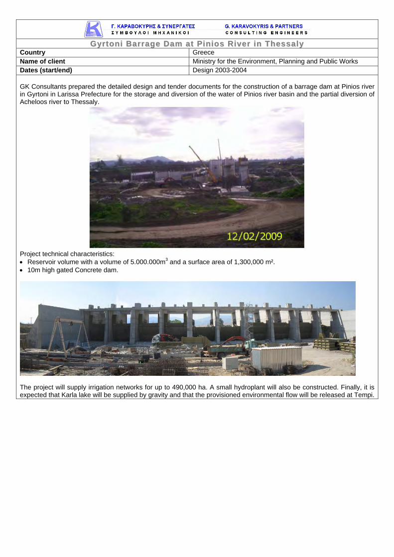
Country Greece Name of client Ministry for the Environment, Planning and Public Works Dates (start/end) Design 2003-2004 GK Consultants prepared the detailed design and tender documents for the construction of a barrage dam at Pinios river in Gyrtoni in Larissa Prefecture for the storage and diversion of the water of Pinios river basin and the partial diversion of Acheloos river to Thessaly.
Project technical characteristics: • Reservoir volume with a volume of 5.000.000m3 and a surface area of 1,300,000 m². • 10m high gated Concrete dam.
The project will supply irrigation networks for up to 490,000 ha. A small hydroplant will also be constructed. Finally, it is expected that Karla lake will be supplied by gravity and that the provisioned environmental flow will be released at Tempi.
Country Greece Name of client MEK Construction Company Dates (start/end) 2005 Detailed design for the construction of a 4.1 MW mini Hydropower Plant (nominal flow 800 l/s, 580 m fall) in Northern Greece. The SHEP was designed by GK Consultants to consist of the following parts:
o The Tyrol – type concrete intake structure accompanied by a silt basin.
o The water conveyance system comprising a pipeline 800 mm dia 6.5 km long. Ductile iron pipes were for the first part of 5 km and steel pipes for the penstock (1.5 km long).
o The power station housing a Pelton turbine, the generator and all relevant equipment. Serious earth retaining works were constructed at the site of the power station, as well as flood protection works.
o Access roads to the intake and the power station of a total length of 3.85 km.
Services provided by GK Consultants:
o Review of existing studies o Complete and detailed design of all works of the project. o Construction drawings. o Consultancy services during construction. o Modifications of construction drawings during the execution of works.
The plant was constructed according to the design and is now operating efficiently.
Country Greece Name of client DIEKAT-Hellenic Construction S.A. Dates (start/end) 2004-2005 The SHEP “Gitani”, with a capacity of 4.2 MW, was designed by GK Consultants and has been constructed on Kalamas River in NW Greece. It consists of the following parts:
• The side weir type intake structure with a capacity of 60 m3/sec
• The power canal and forebay of a total length of 130 m app.
• The power station housing two Kaplan turbines of 2.1 MW each, the generator and all relevant equipment
• The tailrace canal
Services provided:
• Review of existing studies • Complete and detailed design of all works of the project (including the study of transient phenomena) • Construction drawings • Consultancy services during construction • Modifications of construction drawings during the execution of works • Preparation of all relevant material, monitoring of tests and reporting on hydraulic simulation physical
modeling performed in the laboratory of the University of Thrace.
rreeggiioonn ooff EEddeessssaa Country Greece Name of client PPC Renewables Dates (start/end) 2008 GK Consultants undertook with the current contract the preparation of three (3) reconnaissance studies of Small Hydroelectric Projects at the region of Edessa.
ΙΣΧΥΣ & ΕΝΕΡΓΕΙΑ ΣΥΝΑΡΤΗΣΕΙ ΤΗΣ ΟΝ. ΠΑΡΟΧΗΣ ΣΤΡΟΒΙΛΟΥ
The studies were prepared for the following projects:
1. Exploitation of the water fall at Klesohori stream at the area of Edessa 2. Exploitation of the water fall between the flow regulation reservoir downstream of the existing
hydroelectric station at Agra and the location of the dissipating canal upstream of Kioupri – D1 and Edessa waterfalls
3. Exploitation of the water fall at Ano Estia stream at the area of Edessa GK Consultants investigated for each of the project locations their viability for their construction and operation in order to assess the perspective of preparing and submitting licensing files for these projects at RAE (Regulatory Authority for Energy).
FFoorr ttoossiioonn,, TTssiimmoovvoo aanndd GGeerraakkaarr ii PPrroojjeeccttss iinn AArraacctthhooss RRiivveerr ((GGrreeeeccee)) Country Greece Overall project value (EUR) 230,000 Proportion carried out by candidate (%) 100 Name of client IBERINCO HELLAS Techniki & Kataskevastiki EPE Dates (start/end) 2006-2008 The Aracthos River catchment with a total area of 2005 km² is the second largest catchment of the Epirus Water District (second to Aoos River catchment). Aracthos River source is situated over the Tymfi mountain of the Pindus mountain range and as soon as it drains the catchment from north to south it discharges into the Ambrakikos Gulf. The total length of its main branch is 142 km. GK Consultants prepared four (4) separate studies in order to provide all necessary material for the preparation of application documents to be submitted to the Greek Regulatory Authority of Energy for the permitting of the Small Hydro-Power Projects (SHPP) of:
Each study dealt with at a Preliminary Level with all aspects related to construction of the aforementioned SHPPs and affecting costs. All studies contained the necessary information on the following:
o Location o Site geology o Hydrology o Energy characteristics of the project (nominal flow, head, capacity, energy production) o Technical description of civil and electromechanical works o Environmental impacts from the project construction and operation o Budget o Drawings at a preliminary level
All above data were required for the preparation of consistent and reliable application documents. They were also accompanied by a Preliminary Environmental Impact Assessment study, which was also a prerequisite of the permitting procedure. More analytically, the works that were designed were: Elliniko SHPP forms part of a general plan of Rokas Hydroelectric company for the development of hydropower projects in several parts of Greece. River Arachthos, having very favorable hydrological characteristics, is one of the streams where the company plans to develop such projects. The general characteristics of the project: • Nominal flow: 37 m3/sec • Full supply level: +336,00 m • Water elevation at the tailrace canal (for Q =
37 m3/sec): +320,07 m • Nominal head: 15,93 m • Type of turbines: Kaplan with vertical axis • Number of turbines: 2
Plaka SHPP on Arachthos is proposed to be constructed on the main riverbed at a distance of 850 m upstream of the Plaka old arch bridge and 200 m downstream of the exit of the Arachthos limestone gorge. The SHPP is comprised by a gravity concrete dam, at the toe of which the construction of the power station with an installed capacity of 5 MW is foreseen. The general characteristics of the project: • Nominal flow: 52 m3/sec • Full supply level: +254,70 m • Water elevation at the tailrace canal
(for Q = 52 m3/sec): +242,80 m • Nominal head: 11,9 m • Type of turbines: Kaplan with vertical
axis • Number of turbines: 2 The Fortosi SHPP on Arachthos is proposed to be constructed on the main riverbed at a distance of 800 m upstream of the Politsa bridge. The SHPP is comprised by a gravity concrete dam, at the toe of which the construction of the power station with an installed capacity of 5.2 MW is foreseen. The general characteristics of the project: • Nominal flow: 50 m3/sec • Full supply level: +300,00 m • Water elevation at the tailrace canal (for Q = 52 m3/sec): +287,94 m • Nominal head: 12,06 m • Type of turbines: Kaplan with vertical axis • Number of turbines: 2
The Tsimovo SHPP on Arachthos is proposed to be constructed on the main riverbed at a distance of 200 m upstream of the Tsimovo bridge. The SHPP is comprised of a gravity concrete dam, at the toe of which the construction of the power station with an installed capacity of 5 MW is foreseen. The general characteristics of the project: • Nominal flow: 35 m3/sec • Full supply level: +369,00 m • Water elevation at the tailrace canal (for Q = 35 m3/sec): +352,07 m • Nominal head: 17,07 m • Type of turbines: Kaplan with vertical axis • Number of turbines: 2
Gerakari SHPP on Arachthos is proposed to be constructed on the main riverbed at a distance of 400 m upstream of the Papastathi old arch bridge and 2.500 m downstream of the Krapsi road bridge connecting Krapsi and Driskos regions. The SHPP is comprised by a gravity concrete dam, at the toe of which the construction of the power station with an installed capacity of 5,7 MW is foreseen. The general characteristics of the project are the following: • Nominal flow: 30 m3/sec • Full supply level: +438,80 m • Water elevation at the tailrace canal (for Q = 30 m3/sec): +419,18 m • Nominal head: 19,62 m • Type of turbines: Kaplan with vertical axis • Number of turbines: 2
IIddeenntt ii ff ii ccaatt iioonn,, ddeessiiggnn,, pprreeppaarraatt iioonn aanndd ccoonntt rraacctt iinngg ooff ll aarrggee bbuussiinneessss-- rree llaatteedd
Country Romania Name of client Romanian Ministry of European Integration Origin of funding EU-Europeaid-Phare Dates (start/end) 2004-2006 GK Consultants was part of a consortium that undertook this contract for the Romanian Mijnistry of European Integration. The contract included the following:
o Support for implementation of the large-scale infrastructure projects to be financed under Phare 2003 Economic and Social Cohesion component;
o Preparation of technical specifications, bill of quantities, design and tender documents, including drawings based on FIDIC Conditions of Contract for at least 7 infrastructure projects;
o Participation in the works tender evaluation; o Support for contracting the TA for the Supervision of Local and Regional Infrastructure Projects financed under
Phare 2003; o Support for the 8 RDAs, MoEI and Phare ESC Steering Committee for infrastructure component in establishing
the 2004-2006 large infrastructure portfolio. The Consultant revised and improved/up-dated (where necessary) the pre-selected proposals - including feasibility study of investments in infrastructure, financial and cost-benefit analysis and a prioritization of projects to be financed under each programme;
o Support for designing the selection mechanism for establishing the 2007-2013 portfolio of investment projects; o Preparation of Procurement Documentation; o Technical assistance for organizing works tender process in order to ensure proper technical and financial
analysis during tender proceedings and drafting recommendations for the Contracting Authority; o Preparation of the Terms of Reference for management and supervision support for the construction of the local
and regional infrastructure projects; o Elaborating the Guidelines for Applicants.
Type of services provided Feasibility Studies Verification Detail Engineering Cost Estimation Tender Document Preparation (FIDIC conditions) Tenders evaluation Support for the RDAs, MoEI and ESC for infrastructure components in establishing portfolio.
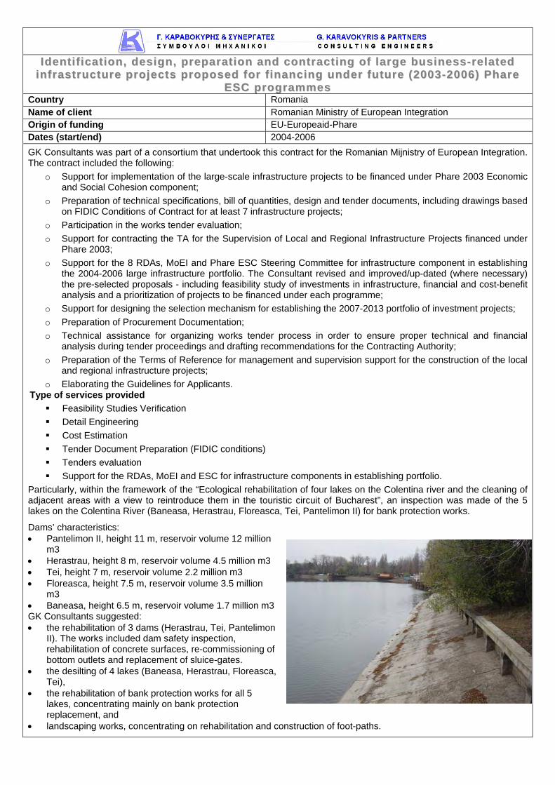
Particularly, within the framework of the “Ecological rehabilitation of four lakes on the Colentina river and the cleaning of adjacent areas with a view to reintroduce them in the touristic circuit of Bucharest”, an inspection was made of the 5 lakes on the Colentina River (Baneasa, Herastrau, Floreasca, Tei, Pantelimon II) for bank protection works.
Dams’ characteristics: • Pantelimon II, height 11 m, reservoir volume 12 million
m3 • Herastrau, height 8 m, reservoir volume 4.5 million m3 • Tei, height 7 m, reservoir volume 2.2 million m3 • Floreasca, height 7.5 m, reservoir volume 3.5 million
m3 • Baneasa, height 6.5 m, reservoir volume 1.7 million m3 GK Consultants suggested: • the rehabilitation of 3 dams (Herastrau, Tei, Pantelimon
II). The works included dam safety inspection, rehabilitation of concrete surfaces, re-commissioning of bottom outlets and replacement of sluice-gates.
• the desilting of 4 lakes (Baneasa, Herastrau, Floreasca, Tei),
• the rehabilitation of bank protection works for all 5 lakes, concentrating mainly on bank protection replacement, and
• landscaping works, concentrating on rehabilitation and construction of foot-paths.
aanndd 1155 ooff tthhee WWaatteerr FFrraammeewwoorrkk DDii rreecctt iivvee ((22000000//6600//EECC)) iinn CCyypprruuss Country Cyprus Name of client Water Development Department (WDD) of Cyprus Dates (start/end) 2008-2011 Cyprus is implementing the Water Framework Directive 2000/60/EC. G.Karavokyris & Partners was the leading consultant for the implementation of articles 11, 13, and 15. In addition, a drought management plan and a management plan for the water resources of the island have been prepared. G. Karavokyris and Partners processed the rainfall, wind, temperature, solar radiation, humidity, streamflow, dam inflow and groundwater records from all stations in Cyprus and created a 36 year database of flow time series for all basins and subbasins of Cyprus. Also, the water balance of all aquifers was estimated with some of the most important modelled with a finite element model (FEFLOW). Also, a drought analysis study was carried out, drought indices for all Cyprus basins (including aquifers) were developed as well as a monthly drought alert status indicator based on the storage available in reservoirs and the associated risk of not meeting water demand for the next 5 year period. Reservoir storage levels were linked to allowable water abstraction on a monthly level. For all dams, environmental downstream discharge was estimated based on analysis of the historic (pre-dam) flow-duration curves that were estimated. A detailed national Drought Management plan was prepared by G. Karavokyris and Partners and approved by the Cyprus Council of Ministers and then submitted to the European Commission as the official country policy on drought management. All EU countries must have Drought Management Plans according to the EU Water Framework Agreement. Cyprus is very water scarce under normal meteorological conditions and this results in high vulnerability to a drought situation. To compound this problem, tourism, which is one of the greatest consumers, peaks during the dry season. Typically in water scarce countries, the degree of exploitation of water resources under normal circumstances is such that there are no strategic reserves, such as groundwater or reservoir storage, left to cope with drought. It was, therefore, vital that the drought management did not only deal with the exceptional drought cases but also with normal water management, since it is under normal circumstances that the reserves to utilize during a drought must be created and preserved. The plan uses a comprehensive set of indices to estimate stress on surface water resources, groundwater, river dependent environment and wildlife and rainfed agriculture and forestry. Index values that will trigger different types of alert were set. The primary triggering index is set to be the Standard Precipitation Index (SPI). Rules were developed, that link allowable reservoir abstractions with stored volumes and similar for groundwater. A large number of mitigation measures were designed, competing stakeholders such as tourism and agriculture taken into account, a draft programme of measures discussed in public consultation meetings and finalized. G.Karavokyris & Partners collected data of all types of water use and developed water balance models that incorporated all uses and all resources. They examined alternative scenaria for the sustainable exploitation of the available surface and groundwater resources of the region along with the use of existing and potentially new desalination plants and recycled water. G.Karavokyris & Partners gave a lot of emphasis in satisfying with very high reliability the water supply demand, covering environmental flow and groundwater level requirements while satisfying with acceptable reliability the irrigation demand. G.Karavokyris & Partners prepared a Programme of Measures with the aim of optimising the time and cost constraints for achieving good ecological status in the water bodies of Cyprus. These measures were then incorporated into a Water Management Plan as per the requirements of the Water Framework Directive. The entire Directive implementation process was also codified in the WISE database. The consortium also undertook with additional contracts: • Strategic Environmental Impact Assessment Study for the implementation of Articles 11 and 13, and the
implementation of Public Consultation - Article 14 (1) (c) of the Water Framework Directive (2000/60/EC) in Cyprus
• Consulting Services for the evaluation of the results of the Surface Waters Monitoring Programmes regarding Article 8 of the Water Framework Directive (2000/60/EC)
Services provided under this contact included: Analysis of water resources Analysis of demand Hydrological modeling Water resources modeling Groundwater modeling Definition of drought indexes Evaluation of water quantity, quality and biological indexes monitoring data Designation of heavily modified water bodies Designation of surface and groundwater bodies at risk of not achieving good ecological status or good
ecological potential Preparation of a report for the revision of Natural Water Policy of Cyprus Preparation of programme of measures Preparation of water management plan Preparation of drought management plan Participation to public consultation Writing of final version of plans following public consultation Preparation of the Cyprus database for uploading to EC WISE database
Country Greece Name of client Ministry of Development Origin of funding 3rd EC Community Support Framework - Ministry of Development Dates (start/end) 2003-2008 A consortium including GK Consultants (leader) was awarded the largest of four contracts with a project area covering more than 50% of mainland Greece. The project aims at the integrated water resources management of the area of interest and the
development of the appropriate management tools. It is intended to assist the Ministry of Development with the implementation of the Water Framework Directive (2000/60). The project includes the following: • The development of a registry with all the relevant environmental,
hydrological and hydrogeological information • The development of an integrated GIS-based database and the
presentation of all the relevant data in maps • Recording of all activities related to water use • Use of surface and groundwater simulation software (MIKE BASIN &
MIKE SHE) • Analysis of developing projects in the greater area and determination of current and future needs
• Development of a management model and its application to the specific River Basin District
• Gathering of economic information related to developing activities in the area
• Development and evaluation of an Economic Model • Dissemination actions: international workshops, training courses,
internet site, documentation and manuals Some of the river basins included in the project area are: -Pinios River. Catchment Area ………………………………..9500 km2
-Acheloos River. Catchment Area ……………………………..4782 km2
-Aoos River (Transboundary Greece & Albania). Catchment Area (Greek Part)……………………………………2140 km2 -Aracthos River. Catchment Area ……………………………2004 km2 Type of services provided • Gathering of all the relevant hydrological, hydrogeological,
meteorological, environmental and economic data in the area of interest • Analysis of the information using the appropriate scientific tools and
software • Development of hydrological-hydrogeological water quality and
management models for basins • Evaluation of the results of alternative management scenaria and selection of the scenario that
best applies to the water resources management in the area of interest
GGrreeeeccee Country Greece Name of client Ministry for the Environment, Planning and Public Works Dates (start/end) 2007-2009
GK Consultants as members of a consortium, were awarded with the contract to support the Special Water Secretary of the Minsitry for the Environment in the implementation of 2000/60/EC Directive (Water Framework Directive) in Greece. The project regards the provision of services for the draughting of various plans concerning the implementation of 2000/60/EC Directive. These include translations of the guidance documents of the Directive, draughting of legal documents (Ministry Decisions), creation of a website for public information, draughting of Directives and training of the personnel of the Regional Water Bureaus of Greece, as well as the customization of the required measures and the draughting of an action plan for each of Greece’s Regions concerning the implementation of 2000/60/EC Directive. Support to the Central Water Agency about (among others):
o The draughting of a programme of actions for the implementation of 2000/60/EC Directive.
o The completion of Article 5 of the Directive. o The writing of draughts of the provisioned legal
documents. o Draughting of guidelines for the implementation
of the Directive at a regional level and the training of the personnel of the Regional Bureaus. o Draughting of proposals for the cooperation with neighbouring countries regarding
transboundary basins. The project was implemented for all Greece territory.
The services provided covered the fields of:
o Gathering all the relevant environmental, hydrological and hydrogeological information. o Analysis of developing projects. o Development of a management model. o Applying the model to specific River Basin Districts. o Development and evaluation of an Economic Model. o Preparation of international workshops, training courses, internet site, documentation and
manuals. o Technical issues regarding cross-border water bodies, monitoring networks, water cost
Country Greece Name of client European Commission – DG XII Dates (start/end) 2002-2004
The objective of AUTO-HAZARD PRO is to integrate real-time and on-line fire and flood hazard management schemes into a GIS-type platform. The system will be run on an operational mode in Disasters Management Centres and in connection with local resource management agencies across hazard-prone EU areas. Specific tasks will be to develop:
(i) an environmental and technological Data Base Management System, with electronic information (i.e., fire occurrence, topography, soils, weather, vegetation, land use, administrative and technical resources) and digital mapping capabilities for natural hazards/fire protection and effects mitigation,
and environmental impact assessment; (ii) (ii) a Decision Support System (DSS) dealing with proactive planning and emergency management of
real-time fire and flood episodes, including fuels management, socio-economic criteria, a priori risk forecasting, automatic fire detection and optimal resource dispatching. Collection, input, storage, management and analysis of the information depend on advanced and automated methodologies using remote sensing, GPS, digital mapping and GIS. Development of the prototype system will be accomplished on 3 study areas in Greece and Spain, with the potential to later encompass whole regions of EU countries on operational basis.
Expected impacts The system will be supported by an operational weather forecasting system that will supply regular 72-hour weather forecasts and, in addition, down-scaled forecasts in the areas of interest. Field sensors of autonomous fire detection will be linked to the operation’s centre within AUTO-HAZARD PRO, where the alarm signal will be evaluated to stimulate proper responses. Short-term dynamic fire and flood danger indices will be developed for better and realistic prevention and pre-suppression planning. Proactive development of such information infrastructure, with the use of computers and the integration of ground and satellite technologies, will assist in prompt resource dispatching, for the initial attack and effective damage mitigation. Type of services providedGK Consultants were the LEADER of Flood Module and Solely Responsible for Flood Hazards (all the other partners were responsible for the Fire Hazards) Objective The overall objective may be that based on real-time or forecasted precipitation and stream flow data through the developed communication network, to incorporate such information into rain-fall-runoff and stream flow routing programs in order to forecast flood flow rates for certain time periods ahead, depending on the watershed and its conditions. Such forecasts may be issued both on a pre-fire and a post-fire time horizon. Work description
o Compilation of meteorological and hydrological data within the watersheds of the area. Selection of the specific watersheds and all the necessary input data for the hydrological analysis.
o Selection of a number of heavy precipitation cases and performance of extensive model experimentation, using the meteorological models. Test of the hydrologic response to changes in vegetation and soil moisture that are supposed to affect the flood as well as its temporal and spatial variability.
o Estimation of the post fire erosion hazard and the sediment transportation. Assessment of the altered hydrologic regime and the corresponding flood events.
o Use of rainfall-runoff models to predict floods given the rainfall inputs from meteorological and statistical models as to the erosion hazard; study of hydrological factors that would lead to the worst flooding conditions and estimation of PMF for specific watersheds. Use of flood routing models to assess the risk in specific areas.
o Identification of the conceptual models that better describe the hydrologic regime and the consequent flood impacts on the selected watersheds. Integration of the entire methodology for flood and early warning system and application to specific study areas.
Country Greece Name of client Ministry for the Environment, Planning and Public Works Dates (start/end) 2002-2004
Kifissos River had been canalised in the beginning of the 20th century with a design capacity of 500 cumecs. A number of floods with increasing frequency exceeded this in 2002. New canalisation of the lower reach, 3 km in length, was urgently designed to increase capacity to 1400 cumecs. Special care was taken to parts of the reach where transcritical flows occur to deal with waves and flow instability. Design was complicated by urban setting, limited access and close proximity of properties and major highways. Services provided by GK Consultants included: • Hydrology including producing new depth-duration-frequency curves for rainfall in Athens basin.
• Hydraulic Numerical Modelling of river reaches. • Preliminary and detailed design of river canalized sections. • Catchment rainfall runoff modelling.• Preliminary and detailed design of flood defence works in catchment. • Preliminary and detailed design of stormwater drainage networks. • Preliminary and detailed design of stormwater storage facilities. • Proposals for planning and management policies in catchment including assessment of proposals and applications for schemes from individual municipalities. • Water depth measurements mapping.
Country Greece Name of client Ministry for the Environment, Planning and Public Works Dates (start/end) 2009-2010
Kifissos is the river draining the Greater Athens Area in Greece. It has a catchment area of 370 km², most of it urban except for the mountainous part of it, which reaches elevations of +1900 m above sea level. The rapid urbanization of the Greater Athens Area and the consequent changes in land use, construction by individual municipalities of drainage networks and adhoc canalisation of upper tributary streams increased multifold the frequency and impact of flooding incidents. Kifissos River had been canalised in the beginning
of the 20th century with a design capacity of 500 cumecs, which was exceeded by a number of floods in 2002. In a previous project assigned to GK Consultants, new canalisation of the lower reach, 3 km in length, was urgently designed to increase capacity to 1400 cumecs. This project included the preparation of an integrated (road and river) Kifissos Stormwater Drainage Study for the section between the estuary and the area of Kokkinos Mylos.
The Study comprised three partial projects:
a) The Preparation of a Unified Operational Registry,
b) The Management Study of Kifissos Road Works and
c) The Management Study of Kifissos River Works,
as well as the required supportive studies and investigations.
The Preparation of a Unified Operational Registry regarded the accurate and detailed recording of the existing situation of both the road and the river works in a unified operational registry.
The Management Study of Kifissos River Works dealt with issues like the renewal of the “stagnant” waters of the downstream section of the river and its cleanup with a pumping station and floodgates, the training of its untrained upstream section, the severe storm hydrology, the updating of the criteria and calculation methods for flood protection works, sediments research, installation of monitoring equipment, as well as a mathematical hydrological model of Kifissos River Basin.
It comprised first the preparation of a Hydraulic Safety Inspection, to define the existing degree of flood protection and water quality of the river works, locate works that had been designed but not yet constructed or finalized as well as new works that had not been designed.
In accordance with the findings of this Inspection, there were prepared a Report for Required Additional Works and Interventions, a Manual for the Operation Control for Stormwater Drainage Works, a Manual for the Maintenance of Stormwater Drainage Works, a Manual for Hydraulic Management and a Manual for Environmental Management.
Country Greece Name of client Water Supply and Sewerage Company of Greater Athens Origin of funding EU Cohesion Fund Dates (start/end) 1993-2007
The coast and plain of Thriassio is located in the vicinity of Athens. It comprises of four municipalities with major industrial and trade areas and a coastal, partly industrial and partly recreational, zone. GK Consultants prepared: • Masterplan and feasibility study for the wastewater and stormwater management of the region.
This included a complete inventory of contributing industrial units and assessment of future population per sub-area to estimate load scenarios, as well as a disposal study for the Elefsis Bay.
• Detailed design and tender documents for the wastewater and stormwater collection systems. • Tender design and tender documents for the sewage treatment works. The equivalent population is about 200,000, The design criteria required significant minimum slopes in order to achieve self cleaning velocities. Due to the great lengths of the trunk sewers and the restricted number of the pumping stations the depth of the trenches exceeded 6 m. Because of the depth and the soil conditions microtunnelling was used as the appropriate method for the installation of many of the sewers. The Elefsis Bay will receive the treated effluents from a single WWTP through a submerged conduit. This solution was found to be optimum compared to others comprising more plants or long distance conveyance of sewage to an existing plant. The bay is characterized as highly eutrophic and considered as a sensitive receiving body according to the EU Directive 91/271. As a consequence, the treatment provisions nutrients removal. The wastewater treatment plant includes the following units: pre-treatment (screening, sand removal), primary sedimentation, activated sludge treatment, including nitrification – denitrification, phosphorus removal, secondary sedimentation, polishing and UV disinfection as well as mechanical thickening, anaerobic digestion and dewatering of produced sewage sludge.
MMaasstteerrppllaann,, FFeeaassiibb ii ll ii ttyy SSttuuddyy,, DDeettaa ii lleedd DDeessiiggnn aanndd TTeennddeerr DDooccuummeennttss ffoorr tthhee
Type of services provided: • Masterplan and Feasibility Study • Site Investigation • Environmental Impact Assessment • Cost Benefit Analysis • Surveying • Hydrology • Inventory of Contributing Industries • Basic Engineering, Detailed Design and Tender Documents for Storm
Drainage and Sewerage Networks • Outfall Study and Disposal to the Sea • Critical Flood Defense Works • Design and Tender Documents of WWTP
cc ii ttyy ooff TThheessssaalloonniikk ii Country Greece Name of client Ministry of the Environment, Planning and Public Works Dates (start/end) 1999-2002
GK Consultants was a member of a consortium that undertook the project for the preparation of a Masterplan for the strategic development, overall management and operation of the sewerage and drainage network of the Thessaloniki Sewerage Company (OATh) and the protection of the natural receiver. The main scope of the Masterplan was the assessment of the future requirements and the selection of the optimum measures for the protection of the coast zone, particularly through the reduction of the discharges of the combined sewer network and the rearrangement of the pipelines and pumping stations of the coast line. The sewerage network of Thessaloniki was simulated in GIS by the use of the software programme ARCINFO. In parallel, a hydraulic simulation was performed by using the software programme MIKE MOUSE.
A rain gauges network and flowmeters for the measurement of the discharge of the sewage networks were installed in order to collect data for the simulation. The final suggestions were selected based on the technical and financial analysis of the alternative scenario. Also, • a design study for the manangement of the sludge produced from the
Thessaloniki STP (Sewage Treatment Plant) was prepared, • a design for the processing of the drainage network filters was introduced, • the organizational structure of the Sewerage Sector of the Thessaloniki Sewerage Company (OATh) was
performed and there were suggested improvement options by “GK Consultants”.
DDeettaa ii lleedd ddeessiiggnn,, tteennddeerr ddooccuummeennttss aanndd ccoonnsstt rruucctt iioonn ssuuppeerrvviiss iioonn ffoorr aa
ssttoorrmmwwaatteerr ddrraaiinnaaggee ssyysstteemm iinn LLaarrnnaaccaa,, CCyypprruuss Country Cyprus Name of client Municipality of Larnaca Dates (start/end) 2010-2012
Larnaca is the third biggest city of Cyprus (population c.150,000) which doubles during the six months of peak tourism.
The project comprised the Detailed design, Tender Documents, Preparation of Operation & Maintenance Manuals for the main stormwater collectors / stormwater drainage systems / pumping stations (the main pumping station had a capacity of 15 m3/s) in the city of Larnaca.
nneettwwoorrkkss ooff tthhee wwhhoollee IInndduusstt rr iiaa ll AArreeaa ooff PPllaatt iiggiiaa ll ii AAssttaakkooss Country Greece Name of client Astakos Terminal Joint Venture Dates (start/end) 2002-2004
The port of Astakos, situated on the Western coast of Greece, between the cities of Igoumenitsa and Patras, was constructed during the 1980’s. The main goal for its construction was to install a unit for ships shattering. However, due to the local community reactions the port did not operate. In 2000 the Greek Government signed a contract with the Joint Venture Astakos Terminal which was committed to alter the existing installations to a modern commercial port and to develop industrial area.
In 2002, GK Consultants was awarded a contract by the J/V Astakos Terminal to assess the existing infrastructure and the designs (Preliminary and Detailed Designs) of the water supply, fire fighting and drainage and sewerage networks for the area of the port and the industrial area of Platigiali Astakos. GK Consultants had to adjust the network designs to the requirements of the New Port.
UUtt ii ll ii ssaatt iioonn ooff AAtthheennss IInntteerrnnaatt iioonnaall AAii rrppoorr tt ((AAIIAA)) SSeewwaaggee TTrreeaattmmeenntt PPllaanntt
((SSTTPP)) TTrreeaatteedd WWaatteerr tthhrroouugghh AAIIAA II rr rr iiggaatt iioonn NNeettwwoorrkk Country Greece Name of client Athens International Airport s.a. (AIA) Dates (start/end) 2008-2010
GK Consultants were awarded the contract for the “Utilisation of AIA STP Water through AIA Irrigation Network”,
which included the preparation of a Preliminary Design with alternative options, the preparation of a Detailed
Design on the preferred option by AIA and the preparation of the Tender Documents. GK Consultants were
responsible for the preparation of all the hydraulic related designs and the overall management of the contract.
The scope of the design was to propose new areas to be irrigated by the Sewage Treatment Plant (STP) treated
effluent with two (2) main objectives:
o disposal and simultaneous reuse through irrigation of larger STP effluent quantities (with a design aim
to consume the quantities to be produced by the STP within a ten (10) year time plan) and
o the irrigation with STP treated effluent of areas non-accessible to the public according to the approved
STP Environmental Permit and the Airport’s Operational License. The proposed non-accessible to the
public areas are currently irrigated by water from the drinking water supply network (supplied by the
Water and Sewerage Corporation of Athens – EYDAP s.a.).
In addition, the design provisioned further treatment (via a special filtering unit) of an additional STP effluent
quantity aiming in the staged replacement of EYDAP water utilized for irrigation purposes:
o to areas that are already irrigated by EYDAP water, through the irrigation network of areas accessible to
the public and
o new areas to be irrigated, which will be developed following the airport’s future expansion (e.g. new
exhibition centre –areas G320– , etc.)
The proposed irrigation design studied the construction of two (2) main supply pipes as follows:
Pipeline A1 aims to dispose off STP effluent secondary treated and subsequently chlorinated as per the
UUtt ii ll ii ssaatt iioonn ooff AAtthheennss IInntteerrnnaatt iioonnaall AAii rrppoorr tt ((AAIIAA)) SSeewwaaggee TTrreeaattmmeenntt PPllaanntt
((SSTTPP)) TTrreeaatteedd WWaatteerr tthhrroouugghh AAIIAA II rr rr iiggaatt iioonn NNeettwwoorrkk current treatment processes applied at the STP. This pipeline is designed to irrigate the largest possible area
(considering irrigation restrictions, such as plantation needs, electrovalves operational durations and soil
adsorption capacity). The total length of pipeline A1 is approximately 3.8 km.
Pipeline B1 aims to irrigate new areas introduced to the irrigation system. Those areas will be supplied in future
by STP treated effluent that should be tertiary treated based on the recently issued applicable legislation (i.e. an
STP permit for the installation of a filtration unit, e.g. using a low-pressure membrane system or other type of
filtration treatment, should be obtained first). This pipeline is proposed to be parallel along the full length of
pipeline A1. Subsequently, pipeline B1 is designed in order to be able to irrigate inclusively some areas at the
north-east section of the airport east-perimeter and then to be directed through the necessary pumping and the
relevant balancing tank to building 63. At this building the main irrigation pumping station of all airport areas is
located, which is currently supplied by the drinking water network (EYDAP).
Finally, the Design included the study (Phase C) for the replacement of EYDAP water with STP treated effluent,
for an approximate volume of 115 m³/day, which currently irrigates the green areas alongside the Main Access
Road (Attiki Odos) through the necessary alternative connections introduced.
Country Greece Name of client Athens International Airport s.a. Dates (start/end) 2006-2009 Athens International Airport s.a. (AIA) had entered into a contract with a Contracting Firm for the construction of the Industrial Waste Treatment Facility (IWTF) at the Olympic Airways Homebase. Also, around the year 2006 AIA was in the process of the evaluation of the tenders received for the Improvements to the Sewage Treatment Plant (STP) and they were to proceed to an award to the successful contractor. AIA was in the need for Technical Assistance to carry out these projects and for this reason they awarded a Consultancy Services contract for the Industrial Waste Treatment Facility (IWTF) at Olympic Airways Homebase and the Improvements to the Sewage Treatment Plant (STP) to GK Consultants. At this stage, GK Consultants liaised with another firm specialising in the wastewater treatment processes for sub-contracting purposes in order to carry out the required Services more efficiently. The tasks carried out under the Scope of the Consultancy Services for the IWTF included:
Weekly visits on the construction site during the installation of the process equipment. Biweekly reports on the progress of approvals, procurement, deliveries, installation, testing and commissioning of the
process equipment, timeline, etc. Review and advice in writing on Contractor’s technical proposals and designs concerning various aspects of plant
components, chemical processes, etc. Review and advice in writing on Contractor’s submissions on plant/equipment in terms of compliance with contract
requirements, compatibility with other plant/equipment and give approvals to proposed materials, purpose made plant and other mechanical or process equipment.
Carry out inspections on factories where equipment or plant is being manufactured to check quality of construction techniques and compliance with contract requirements.
Supervise testing and commissioning process upon completion of installation work and advice on satisfactory operation of the plant prior to issuing the Taking over Certificate.
Audit visits on a monthly basis during the first six (6) months of operation of the facility and thereafter on bimonthly intervals and preparation of relevant reports with information regarding operational status, results, problems, legal compliance, suggested solutions, etc.
IWTF Iinlet Works and Dissolved Air Flotation – DAF – Unit)
GK Consultants were also responsible for carrying out the following tasks for the Consultancy Services for the STP:
Review and advice in writing on the progress of works and on the Contractor’s technical proposals and designs concerning various aspects of plant components, chemical processes, etc.
Review and advice in writing on Contractor’s submissions on plant/equipment in terms of compliance with contract requirements, compatibility with other plant/equipment and give approvals to proposed materials, purpose made plant and other mechanical or process equipment.
Supervise testing and commissioning process upon completion of installation work and advice on satisfactory operation of the entire plant prior to issuing the Taking over Certificate for the new installations.
Audit visits on a monthly basis during the first six (6) months of operation of the facility and thereafter on bimonthly intervals and preparation of relevant reports with information regarding operational status, results, problems, legal compliance, suggested solutions, etc.
CCoonnssuull ttaannccyy SSeerrvviicceess eenntt FFaaccii ll ii ttyy aatt OOllyymmppiicc