Feasibility study for implementation of sedimentation reduction measures inriver harbours
H.J. BarneveldHKV consultants, Lelystad, The Netherlands
J. HugtenburgMinistry of Transport, Public Works and Water Management, The Hague, The Netherlands
ABSTRACT: Sedimentation in river harbours is a serious problem in the Netherlands. Costs for removal,transport, processing and storage of this (often contaminated) sediment are high. In addition sedimentation anddredging activities hinder inland navigation.
Harbours are often designed based on requirements imposed by safe and efficient navigation. In the pastdecades many (mainly desk and/or laboratory) studies have been carried out aiming at the reduction of harboursiltation rates. From these studies, it follows that reductions in siltation rates up to 50% may be reached. However,only few of such sedimentation reduction measures have been implemented. This study aims at exploring thepossibilities to apply simple and effective siltation reduction measures in the harbours along the rivers in theNetherlands. From about 200 harbours along the River Rhine and River Meuse three harbours were selected. Thisselection was made in close consultation with experts and stakeholders, based on among others the siltation rate,harbour geometry from remote sensing images, flow velocities and representativeness for Dutch river harbours.One of the three harbours was further elaborated in a first design.As distinct from preceding studies the design forthis pilot project has been made using field data and expertise of river managers and specialists, but without physi-cal scale model studies and numerical experiments. In addition a simple cost benefit analysis has been carried out.
It is expected that this study will be continued with a detailed design of the selected measure. Ultimatelythis will lead to a prototype implementation in 2008. Such a pilot project combined with a sound monitoringprogram will show the feasibility of the followed approach. In addition it will provide valuable information onmorphological impacts of a structural measure in prototype situations.
1 INTRODUCTION
1.1 Background and social relevance of study
Approximately nine million cubic meters of silt andsand is annually deposited in and along the main riversin the Netherlands (River Rhine and River Meuse).Harbours and its entrances are notorious locations forsuch undesirable sedimentation. Removal, transport,processing and storage of this (often contaminated)material costs about M€120 every year, for whichthe Ministry of Transport, Public Works and WaterManagement is partly responsible.
The main consideration for harbour entrance designis nautical navigation. For an optimal nautical naviga-tion, harbour entrances should be as wide as possible.This however also maximizes the volume of sedi-mentation in the harbour and its entrance. Intelligentdesign of harbour entrances, using state of the arthydraulic en morphologic knowledge can howeverlead to harbours that are both well accessible and less
prone to sedimentation. This study aims to explorethe possibilities to apply simple, robust and effectivesedimentation reduction measures in existing and newharbours along rivers in the Netherlands.
1.2 Previous studies, pilot projects andbarriers for implementation
In the past decades many (mainly desk and/or labo-ratory) studies have been carried out aiming at thereduction of harbour siltation rates. PIANC (2006)presents an overview.A prototype example is the appli-cation of a Current Deflecting Wall (CDW) in the tidalharbour Köhlfleethafen in Hamburg, Germany (Win-terwerp, 2005). Despite of this successful example(a reduction of ca. 40% of the siltation rates), struc-tures to reduce harbour sedimentation are not/hardlyapplied in the main river branches in the Netherlands.This is thought to be largely due to the inertia of theresponsible water managers, thus preventing a possibleparadigm shift to take place. This inertia is mainly
1187
based on a lack of experience with design, construc-tion and efficacy of sedimentation reduction measures.This study (which is part of the programme WaterINNovation source, WINN, supported by the Ministryof Transport, Public Works and Water Management)therefore aims at preparing and implementing a pilotproject in order to gain experience with the effective-ness of sedimentation reduction measures in harboursalong the rivers Rhine and Meuse.
2 METHOD OF STUDY
2.1 Process followed
First step in the project was to make an inventoryof the relevant physical processes. First a literaturesurvey on fluid dynamics, sediment load and mor-phology around harbour entrances was carried out.This included an assessment of the design param-eters relevant for sediment exchange through theharbour entrance and sedimentation rates. In additionnational and international experts were asked to fillin a questionnaire in this field. The results of the lit-erature survey and expert consultation are found inSection 3.
In a second step river base data for harbours in theNetherlands were collected and a short list of possiblepilot-locations was established.
Since the chances for a successful pilot projectdo not only depend on technical aspects, but also onpractical and political aspects, two workshop sessionswith water and harbour managers were organized asa third step. In these sessions a confrontation wasmade between technical data and practical aspects withregard to a possible implementation of measures. Thefirst session, which was held in November 2006, ledto the selection of three harbours of which a sedimen-tation reduction can be reached through an innovativeharbour entrance design (adaptation of the entranceor sedimentation reduction measures). These harbourswere: a recreational harbour in Roermond (along theriver Meuse), the harbour of Haaften (river Rhine) andthe harbour of the Amer electricity generating sta-tion (river Meuse). These harbours are described inSection 4.
Practical aspects eventually led to the harbour ofthe Amer electricity generating station to be the objectof further study. In a second workshop session withexperts and water managers, a sustainable measurefor this harbour was selected to be elaborated furtherincluding a rough design and cost benefit analysis,which are described in Section 5.
2.2 Data collection
Within the relevant regional departments and threespecialist services of the Ministry of Transport, Public
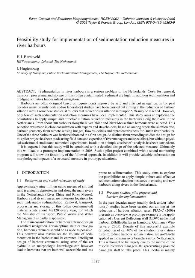
Figure 1. Horizontal entrainment mechanism.
Works and Water Management a questionnaire wasdistributed so as to collect data on:
1. dredging volumes in Dutch rivers, canals andharbours;
2. particular data for individual river harbours relatedto parties involved (ownership, stakeholders),geometry, sedimentation (rates, location, compo-sition), causes of that, future plans for the harbour.
The collected data was combined with aerial pho-tographs (Google Earth) to prepare a fact sheet perharbour. These fact sheets proved to be valuable in thepreparation of a short list of potential harbours for thepilot.
3 LITERATURE SURVEY
3.1 Fluid dynamics, sediment load andmorphology around harbour entrances
Possible mechanisms responsible for sedimentationare extensively reported in literature. Langendoen(1992), Winterwerp (2005) and PIANC (2006) providean overview. Most important mechanisms are:
1. horizontal entrainment (turbulent mixing layer)2. tidal filling3. density currents
In river systems horizontal entrainment is the mainmechanism, which is therefore considered in this paper(Figure 1).
According to van Schijndel and Kranenburg (1998)the sediment flux F through the harbour entrance canbe described with:
with:cr = mean sediment concentration in riverch = mean sediment concentration in harbourur = mean flow velocity riverA = flow area harbour entrancek = exchange coefficient
1188
Equation (1) shows that the sediment flux willreduce linearly with smaller cr, ur, A and k. The firsttwo parameters are difficult to change, but influenc-ing A and k appears to be feasible. As the vortexesin Figure 1 prove to be important for the magnitudeof the exchange coefficient k , additional attention waspaid to the generation, growth and diminishing of thesestructures. It appeared that the bigger and more intensea vortex is, the larger the sediment flux will be. Thesediment flux can be reduced by:
1. suppressing the intensity and dimension of the vor-texes that are shaken off at the upstream point ofthe entrance. This can be reached by reducing theflow velocity in the river (influencing the intensityof the vortex) or influencing the shape of the pri-mary eddy (influencing the space left over by thiseddy for generation of the vortex);
2. limiting the growth of the vortex in the mixing layer.Widening of the mixing layer may realise this;
3. transition of the stagnation point so as to guidemore vortexes reaching the downstream point ofthe harbour entrance back to the river.
Measures to realise this are presented in the nextparagraph.
3.2 Harbour entrance designs effectivefor reduction of sedimentation
Based on descriptions in literature eight possiblemeasured were identified to:
1. reduce the shaking-off of vortexes;2. reduce the flow area of the harbour entrance;3. move the stagnation point;4. reduce the sediment concentration of the water
flowing into the harbour;
Figure 2 shows seven of the eight identified mea-sures. Narrowing the entrance by construction of abottom sill is not included in the Figure.
The current deflecting wall (CDW) reduces theshaking-off process of vortexes, diverts the entrain-ment mixing layer away from the entrance and preventshigh concentrations near the bed from entering theharbour. A pile groyne widens the mixing layer andreduction of the flow velocity in the river. This sup-presses the generation and growth of vortexes. Adividing wall with upstream sill at the upstream side ofthe harbour leads relatively clear water to the harbourand prevents water with high sediment concentrationsfrom entering the harbour. Narrowing the entranceand construction of a sill to shallow the entrance bothreduce the flow area of the harbour entrance, and thusthe sediment flux. Adaptation of the harbour mouthdownstream or upstream may shift the stagnation pointrespectively suppress the process of shaking-off ofvortexes. A semi-permeable screen diverts the upperpart of the water column towards the harbour. This
Figure 2. Measures to reduce the sediment flux.
Table 1. Measures and their influence.
Reduceflow
Reduce the area of Move the Reduceshaking-off harbour stagnation incomingof vortexes entrance point concentration
CDW +? + +Pile groyne + +Dividing + +wall & sill
Narrowing +entrance
Shallowing +entrance
Adaptation + + + +downstream
Adaptation + +upstream
Semi- +? +permeablescreen
introduces a spiral motion leading the water near thebed (with most sediment) towards the river.
Table 1 presents the potency of these measuresto influence the main mechanisms of sediment fluxtowards river harbours.
In addition the impacts of the measures for allriverine functions (navigation, safety, nature) wereassessed.
The quantitative impact of a measure depends onlocal circumstances. The study aimed at designing a
1189
Figure 3. Location three harbours.
measure for a pilot harbour without extensive addi-tional physical or mathematical modelling. There-fore also the possibility for quantifying the effect ofthe measures on the sedimentation process withoutadditional study was assessed.
4 POSSIBLE LOCATIONS FORIMPLEMENTATION OF SEDIMENTATIONREDUCTION MEASURES
Figure 3 shows the location of three (out off appr. 200)selected harbours. This selection has been made inclose consultation with experts and stakeholders basedon among others the siltation rate, harbour geome-try from remote sensing images, flow velocities andrepresentativeness for Dutch river harbours.
4.1 Recreation harbour of Roermond(river Meuse)
The recreational harbour of Roermond in the riverMeuse faces sedimentation problems since severalyears. Some studies have been executed showing thatreduction of the entrance area would be a feasible solu-tion. All stakeholders support a sustainable solutionand the geometry of river and harbour appear to berepresentative for much more river harbours.
The municipality of Roermond recently approveda design by a consultant to realise this area reduc-tion. Both the width and depth of the entrance willbe reduced.
For this study this meant that an alternative designwas not desirable. However, the implementation of theproposed measure may provide valuable informationon the efficacy of it. Therefore a future activity con-cerning the design and implementation of a monitoringplan will be considered.
4.2 Harbour of Haaften (Rhine)
The harbour of Haaften serves as a resting harbour forinland navigation along the Rhine branch Waal. Apartfrom the sedimentation problem (>3,000 m3 annually)
the harbour entrance causes problems for safe arrivalin the harbour. This is especially the case during highwater when the harbour entrance is submerged. There-fore studies are underway to adapt the harbour andentrance geometry so as to increase the capacity andmake the harbour safer. Unfortunately data collec-tion for this harbour faced delay, due to which nopreliminary design for a sedimentation reduction mea-sure could be preformed. However data collection willcontinue as a preparation for future studies for thisharbour.
4.3 Harbour of the Amer electricity generatingstation (Bergsche Meuse)
The sedimentation in the mouth of this harbour issuch, that on average a volume of 7,000–11,000 m3
of sand and (contaminated) silt is dredged annually.Both the management of the station and the river man-ager support a solution that can reduce the dredgingcosts and hindrance for navigation due to sedimenta-tion and dredging works. In addition sufficient datais available to make a first design of a sedimentationreduction measure.
Although the harbour is located in a complex envi-ronment with different waterways meeting each other,and extraction of cooling-water (maximum 30 m3/s)via the harbour, a pilot implementation for this harbourwill provide valuable information on the performanceof a measure and impacts on flow patterns. This pilotproject is further elaborated in the next section.
5 TOWARDS A SUSTAINABLE REDUCTIONOF SEDIMENTATION IN THE AMERPOWER STATION RIVER HARBOUR
Aim of the study was to prepare a design for anadapted harbour geometry or a sedimentation reduc-ing measure based on available field data, some
1190
exploring numerical flow simulations and engineer-ing judgement. This means no extensive studies withphysical scale models or numerical experiments. Mostimportant result should be a pilot project and soundmonitoring programme so as to learn in the field.
5.1 Harbour and sedimentation characteristics
The harbour area is about 17.5 ha large. The har-bour entrance is 120 m wide and the opening betweenBergsche Maas and Donge approximately 185 m wide.Main discharge comes through the Bergsche Maaswith an average annual flow of about 300 m3/s andflood discharges of 1000 m3/s and higher. Dischargethrough the Donge is usually small (less than 3 m3/s).The influence of the tide is still noticeable in theharbour, but reverse (upstream) flow is rare.
At two locations cooling-water for the power stationis withdrawn.These locations are at the Bergsche Maasand in the harbour (both maximum 30 m3/s). Espe-cially in the winter season (September-March) fullcooling-water capacity is used. Figure 5 shows a cal-culated flow pattern with a mean discharge BergscheMaas of 300 m3/s and a cooling-water withdrawal of30 m3/s.
Sedimentation in the area of the harbour, itsentrance, the river and the mouth of the Donge isestimated to be 12,500–21,000 m3 per year. About7,000–11,000 m3 of this is found in the area of theharbour entrance and Donge mouth. 50% of this mate-rial is (contaminated) silt. This means that all dredgedmaterial has to be disposed at special sites.
Most sedimentation occurs during the high waterseason (October-March) when river discharges andsediment concentrations are high.
5.2 The proposed solution
Based on the information available for the harbour sixpossible measures for a pilot project were identified.Of the 7 measures presented in Figure 2 the followingmeasures were considered not-feasible:
• A Current Deflecting Wall was rejected becausethis measure certainly needs additional study in thecomplex situation of this harbour.
• Adaptation of the mouth/entrance upstream ordownstream was considered not-feasible because ofthe local geometry and presence of infrastructure.
A sediment trap upstream of the harbour entrance wasadded as a possible measure.
In Table 2 the remaining measures are assessedon their expected efficiency for the situation withand without withdrawal of cooling-water through theharbour.
As the sedimentation process mainly takes place inthe high-water season and cooling-water withdrawalis continuous then, only the diving wall with sill,
Figure 5. Flow pattern at 300 m3/s with 30 m3/s cool-ing-water withdrawal, calculated with FINEL.
Table 2. Assessment measures with and without cooling-water withdrawal.
secondary channel through the upstream floodplainand the sediment trap upstream of the harbour entranceappear to be feasible. The first two measures aim atleading relatively clear water from the upper part ofthe water column to the harbour. The sediment trapprevents the sand fraction of the sediment load fromentering the harbour.Taking into consideration that theproposed measure should be applicable for other riverharbours the dividing wall with sill was selected forfurther elaboration.
Figure 6 shows a first design for this measure.Based on experiences from the river manager and
experts from specialist services and consultants a firstestimate was made of the expected impact of the mea-sure on the sedimentation rate. It is expected that theinflow of sand may be reduced by 50%. This meansthat the total sedimentation rate (of sand and silt) willbe reduced by 25%.
When the measure is implemented a soundmonitoring programme has to be implemented. Thisprogramme should record the existing situation andfollow the developments after construction.
1191
Figure 6. First design dividing wall and sill.
The monitoring programme will survey:
• Bed development. Coupled to the regular soundingssome additional local measurements are foreseenafter (1) floods, (2) dredging, (3) particular events(e.g. dredging in the main river);
• Flow patterns in river and harbour;• Composition of the bed material in river, entrance
and harbour.
5.3 Rough cost benefit analysis
Costs of the measure are related to (detailed)design, construction and maintenance. Benefits are thereduced dredging activities. Less hindrance for inlandnavigation is not taken into consideration for this anal-ysis. Based on costs of € 5 per m3 dredged material,11,250 m3 reduction in the annual dredging volume,construction costs of € 250,000, a discount-rate of2.5% and a life-cycle period of 30 years the Net PresentValue NPV (2007) for the average estimate is approxi-mately € −9.000, meaning that the investments for themeasure will not pay back completely in 30 years. Forthe optimistic estimate of 13,750 m3/s dredged volumereduction the NPV increases to € +45,000. However apessimistic assumption (only 8,750 m3 reduction peryear) will result in a NPV of €−62,000.
6 DISCUSSION
Objective of the study was to elaborate a first designof a sedimentation reduction measure in a Dutch riverharbour. This should be achieved by a study basedon field data and experiences of river managers andexperts. Extensive physical scale modelling or numer-ical modelling did not form part of the study. Whenimplementation of a measure designed in this wayproves to be effective, this approach can be adopted forother locations. Intensive and specific monitoring is animportant pillar of the approach that can be describedwith learning in the field.
It is proposed that parallel to the preparation of thestudies some numerical experiments and perhaps a fewsimple physical scale model tests (e.g. flume study)will be carried out to further refine the design. In thisperiod also the reference situation (existing situation)should be recorded as a first phase of the monitoringprogramme.
ACKNOWLEDGEMENTS
The study was carried out by three consultancy firmsin close co-operation with experts from specialistservices and regional divisions of the Ministry ofTransport, Public Works and Water Management. Theauthors wish to thank the other members of the projectteam: Bram van Prooijen (Svašek hydraulics), NicoStruiksma (Struiksma River Engineering), Paul Ter-mes (HKV consultants), Maarten van der Wal(Road and Hydraulic Engineering Institute, Ministryof Transport, Public Works and Water Management)and Arjan Hijdra (Civil Engineering Division, Min-istry of Transport, Public Works and Water Manage-ment).
REFERENCES
Langendoen E.J. (1992). ‘Flow patterns and transport ofdissolved matter in tidal harbors’. PhD thesis, DelftUniversity of Technology.