UDK 551.4.037:550.81:528.88:551.4 Izvorni znanstveni èlanak Features of Slope Inclination and Planar Curvatures of the broader Area of Duvanjsko polje Denis RADOŠ, Sanja LOZIÆ, Ante ŠILJEG – Zadar 1 , Mladen JURIŠIÆ – Osijek 2 ABSTRACT. In this paper, quantitative geomorphological features (slope inclina- tions, profile and planar curvature) of mountain rims of Duvanjsko polje were analyzed. Recent shape of this area is a consequence of series of natural and social impacts during relief genesis and evolution. The aims of this research are analysis of quantitative features of hillslope inclinations and curvatures of morphological units in wider Duvanjsko polje area, interpretation of results and synthesis, so more de- tailed insight in hillslope features and processes can be achieved and evaluation of nature of dominant geomorphological processes can be obtained. During this task, special attention was given to a detailed geomorphometric analysis in GIS environ- ment based on a digital relief model. The analysis was conducted in several phases: 1. comparative analysis of hillslope characteristics based on morphological units, 2. comparative analysis of hillslope curvatures and 3. analysis of relationship between slope inclinations and curvature features. Synthesis included interpretation of obtained results in wider context of relationship between morphometric features and structural/lithological features of morphological units. Keywords: broader area of Duvanjsko polje, morphological units, hillslope inclina- tions, profile and planar curvature, morphometry, GIS, DTM. 1. Introduction This paper analyzes specific features of hillslopes of morphological units located on the broader area of Duvanjsko polje, with inclination >2°, i.e. the area of mountainous rim of Duvanjsko polje. The recent shape of slopes of this area is the Radoš, D. et al.: Features of Slope Inclination and Planar Curvatures…, Geod. list 2012, 4, 273–301 273 1 Denis Radoš, mag. geogr., Department of Geography, University of Zadar, Franje Tuðmana 24i, HR-23000 Zadar, Croatia, e-mail: [email protected], doc. dr. sc. Sanja Loziæ, Department of Geography, University of Zadar, Trg Kneza Višeslava 9, HR-23000 Zadar, Croatia, e-mail: [email protected], Ante Šiljeg, prof., Department of Geography, University of Zadar, Franje Tuðmana 24i, HR-23000 Zadar, Croatia, e-mail: [email protected], 2 prof. dr. sc. Mladen Jurišiæ, Faculty of Agriculture, University J. J. Strossmayer, Trg Sv. Trojstva 3, HR-31000 Osijek, Croatia, e-mail: [email protected].
ABSTRACT. In this paper, quantitative geomorphological features (slope inclina-tions, profile and planar curvature) of mountain rims of Duvanjsko polje wereanalyzed. Recent shape of this area is a consequence of series of natural and socialimpacts during relief genesis and evolution. The aims of this research are analysis ofquantitative features of hillslope inclinations and curvatures of morphological unitsin wider Duvanjsko polje area, interpretation of results and synthesis, so more de-tailed insight in hillslope features and processes can be achieved and evaluation ofnature of dominant geomorphological processes can be obtained. During this task,special attention was given to a detailed geomorphometric analysis in GIS environ-ment based on a digital relief model. The analysis was conducted in several phases:1. comparative analysis of hillslope characteristics based on morphological units,2. comparative analysis of hillslope curvatures and 3. analysis of relationshipbetween slope inclinations and curvature features. Synthesis included interpretationof obtained results in wider context of relationship between morphometric featuresand structural/lithological features of morphological units.
Keywords: broader area of Duvanjsko polje, morphological units, hillslope inclina-tions, profile and planar curvature, morphometry, GIS, DTM.
1. Introduction
This paper analyzes specific features of hillslopes of morphological units locatedon the broader area of Duvanjsko polje, with inclination >2°, i.e. the area ofmountainous rim of Duvanjsko polje. The recent shape of slopes of this area is the
Radoš, D. et al.: Features of Slope Inclination and Planar Curvatures…, Geod. list 2012, 4, 273–301 273
1 Denis Radoš, mag. geogr., Department of Geography, University of Zadar, Franje Tuðmana 24i, HR-23000Zadar, Croatia, e-mail: [email protected],doc. dr. sc. Sanja Loziæ, Department of Geography, University of Zadar, Trg Kneza Višeslava 9, HR-23000Zadar, Croatia, e-mail: [email protected],Ante Šiljeg, prof., Department of Geography, University of Zadar, Franje Tuðmana 24i, HR-23000 Zadar,Croatia, e-mail: [email protected],
2 prof. dr. sc. Mladen Jurišiæ, Faculty of Agriculture, University J. J. Strossmayer, Trg Sv. Trojstva 3, HR-31000Osijek, Croatia, e-mail: [email protected].
consequence of effects of various natural and anthropogenic factors that occurredduring the genesis and evolution of the terrain.
Aims of this research are the analysis of quantitative features of slopes andplanar curvatures of morphological units of broader area of Duvanjsko polje, theinterpretation and synthesis of results in order to achieve a more detailed insightinto characteristics of slopes and slope-related processes on the researched area,but also to enable the estimation of characteristics of dominant geomorphologicalprocesses. Additionally, a special attention is given to a more detailed geomor-phometrical analysis of morphological units of the broader area of Duvanjskopolje in GIS environment, based on the digital terrain model (DTM).
For the purposes of this research, a digital raster terrain model of of the broaderarea of Duvanjsko polje was made by automatic vectorization of isolines fromtopographic maps scaled 1:25 000. From that model, a series of data on slopes andcurvatures were attained (both planar and profile curvatures). A detailed analysisof the available bibliography on structural and lithological features and theemployment of GIS methods is also included, most notably the digital analysis ofthe terrain model (Franklin 1987, Dikau 1989, Jordan and Csillag 2001, Dikau etal. 2004, Ganas et al. 2005, Li et al. 2005, Smith and Clark 2005, Pike et al. 2009).
The analysis was carried out in a number of phases: 1. comparative analysis ofslope inclinations with respect to morphological units, 2. comparative analysis of -features of planar curvature with respect to morphological units, 3. relation betweenslope inclination and features of curvatures of morphological units. The synthesisincluded interpretation of results in a broader context of relation between morpho-metrical features of slope inclination and planar curvature on one side and structu-ral and lithological features of morphological units on the other side.
By application of quantitative and geomorphological approach within the analysisof slope features it is possible to analyze their connection to geological structureand content, as well as exogeomorphological factors (e.g. climate, pedology, vege-tation etc.) and enable an estimation of stability, hence setting up a methodologi-cal framework that can be applied in practical purposes (construction, tourism,agriculture etc.). Most researches have shown that data on slope features andplanar curvatures often indicate size, intensity and consequences of exogenousgeomorphological processes within local context (Evans 1972, Evans 1980,Armstrong 1987, Zevenbergen and Thorne 1987, Parsons 1988, De Oliveira 1990,Evans and Cox 1999, Roering et al. 1999, Rieke-Zapp and Nearing 2005, Di Ste-fano et al. 2000, Loziæ 2001, Pahernik 2007, Ohlmacher 2007), or endogenous(primarily neotectonical) morphostructural processes on a regional level (Thorneet al. 1987).
2. Researched area
Geotectonically speaking, the broader area of Duvanjsko polje is high karst or“cover of high karst” (Èièiæ 2002). The total researched area is 250.9 km2. The ol-dest layers of this area are made up from limestones and dolomites from Jurassicperiod, while Cretaceous limestones, and dolomites to a lesser extent, are mostwidely spread.
274 Radoš, D. et al.: Features of Slope Inclination and Planar Curvatures…, Geod. list 2012, 4, 273–301
Newer layers are represented mostly by paleogenic limestone and clastite as wellas lake sediments of Miocene. Structural units were shaped by the end of Paleo-gene, and were affected by significant vertical movement in Neogene, whichcaused a disturbance in the order of layers (Papeš 1985). Within the researchedarea eight morphological units were identified due to variable lithological contentand structure, and in order to enable a more detailed analysis and comparison(Fig. 1).
In order to achieve a better understanding of causality between geologicalfeatures and quantitative indicators of slope inclinations and curvatures, ashort overview of basic geological features of morphological units is presented(Fig. 2).
Radoš, D. et al.: Features of Slope Inclination and Planar Curvatures…, Geod. list 2012, 4, 273–301 275
Fig. 1. Geographical location of morphological units of broader Duvanjsko polje area.
2.1. Vran
The morphological unit of Vran mountain is the smallest in area, only 6.7 km2.From the morphological unit of Lib Mountain to the south it is divided by Grla –Svinjaèa fault, while the fault located in a ravine from Podkose to Omrèenica cre-ates the northern border towards the morphological unit of Ljubuša mountain.Vran Mountain stretches from east to west. This morphological unit is mostlymade up from Malm limestone and dolomite, while the southern part is made upfrom limestones of late Cretaceous period.
276 Radoš, D. et al.: Features of Slope Inclination and Planar Curvatures…, Geod. list 2012, 4, 273–301
Fig. 2. Geological map of the researched area, morphological units (1 = Vran, 2 = Lju-buša, 3 = Jelovaèa, 4 = Tušnica, 5 = Tomislavgrad hills, 6 = Grabovica, 7 =Mesihovina, 8 = Lib).
2.2. Ljubuša
The morphological unit of Ljubuša Mountain rims Duvanjsko polje from east,from the Mokronoge to Lipa. The total area is 77.4 km2. It stretches in directionfrom southwest to southeast, and near the village of Mandino selo it starts tocurve and change direction to “Vran” type (W-E). The area of the morphologicalunit between Vedašiæ and Mandino Selo is characterized by numerous faults,overthrusts and crusts. Rock composition is mostly homogenous in form of sedi-ments from early Cretaceous period. This is mostly the case of limestones, whiledolomites make up a wider area only east of Vedašiæ. Limestones of late Creta-ceous period are present only in the far northern rim of this unit. The mostrecent layers are those of Oligocene-Miocene conglomerates, which are presentaround Šujica canyon, near Mokronoge.
2.3. Jelovaèa
Šujica canyon in the east separated this unit from the unit of Ljubuša mountain.The morphological unit of Jelovaèa rims the Duvanjsko polje from the north. Jelo-vaèa stretches from east to west, which is caused by neotectonic movements thataffected this area in Miocene period. In the eastern part of this unit, the most pre-sent rocks are Malm limestones and dolomites that shift into limestones of earlyCretaceous period towards the west. Limestones of late Cretaceous period appearonly partially, and mainly in the middle section of this unit. The most recent la-yers of sediments are Miocene marl, sands and conglomerates that show up inVuèipolje, which makes a triple boundary between this unit and the units ofTušnica and hills of Tomislavgrad. This morphological unit has the total area of16.9 km2.
2.4. Tušnica
The morphological unit of Tušnica Mountain is divided from Jelovaèa to thenorth by a fault stretching from Buhovo, across Vuèipolje and further west. Tothe east, the border with Tomislavgrad hills stretches from Vuèipolje along theline of Ostro�ac stream to the village of Jošanica. To the southwest, a mountainpass Privala designates the border with Grabovica unit. Tušnica unit is mademostly out of sediments from late Cretaceous period, and, to a lesser extent, outof Miocene marl. Tušnica stretches from east to west, and its genesis is connectedwith neotectonic movements from late Miocene. The most recent layers are mora-ines near Vuèipolje. This morphological unit has the total area of 17.8 km2.
2.5. Tomislavgrad hills
Tomislavgrad hills are made completely out of marl that is lake sediment fromMiocene. These layers have been washed away by rivers in some parts of Du-vanjsko polje, as well as torrenting streams which flow toward the field or havebeen covered by more recent sediments. These sediments were elevated above thelevel of the field by neotectonic movements and make an appendix of TušnicaMountain. Tomislavgrad hills have the total area of 21.8 km2.
Radoš, D. et al.: Features of Slope Inclination and Planar Curvatures…, Geod. list 2012, 4, 273–301 277
2.6. Grabovica
The morphological unit of Grabovica rims the Duvanjsko polje from the west andit is completely made out of limestone dating from the transition from early tolate Cretaceous period. It is in fact a karst plain with a protruding anticline in itssouthern part, which is Midena Mountain. Its total area is 45.7 km2.
2.7. Mesihovina
The morphological unit of Mesihovina includes the southern part of Duvanjskopolje. It is divided from the morphological unit of Grabovica to the west by a faultstretching from NE to SW. To the northeast, it is divided from the morphologicalunit of Lib by a narrow and short valley of the Studena stream. This morphologi-cal unit is mostly made out of Paleogenic clastite layers of conglomerates frommiddle Oligocene (E, O1). Layers of limestone (K2,3/2) appear at the transitionsfrom Grabovica to Lib morphological unit, as well as Glavica area, which constitu-tes a tectonic window. It has a total area of 24.5 km2.
2.8. Lib
The oldest sediments in the morphological unit of Lib are made out of limestoneand dolomite from Jurassic period (J2,3/3). They appear in a narrow regionbetween the rim of the field and the Lib Mountain ledge, near the village ofBorèani, as well as NE side of Lib Mountain, where they cover the older Cretaceoussediments from NE direction. They transition into sediments from early Creta-ceous period towards south and southeast, which are mostly made out of gray dolo-mite rocks, interchanging with limestone. Stretching from Omolje in the directionof south-southeast, sediments transition to gray limestones of Albian-Cenomanianperiod. Sediments from late Cretaceous period can be found on several locations(e.g. the area of Lib Mountain edge). Northeastern and southwestern border ofthese sediments are characterized by overthrusts, and between two of such thruststhe ravine of Kongora – �abljak is located. The most recent sediments of Lib unitare made out of marl and clay, in the area of Kosovac. Its total area is 39.9 km2.
3. Methodology
Digital terrain model is used to describe geomorphological, hidrological and biolo-gical processes on the surface of Earth (Moore et al. 1991, Dietrich et al. 1993).The process that describes terrain in a quantitative manner is known as digitalterrain analysis (DTA). DTA is a totality of techniques used for topographicanalysis and performance of various terrain-related parameters (morphometric,hidrological, climatological) from a digital terrain model, or DTM (Hengl et al.2003). Slope inclination and curvature are local terrain parameters (Olaya 2009).Slope inclination is a first derivative of surface, while curvature represents asecond derivative (Moore et al. 1991, Zeverbergen and Thorne 1987). For thepurposes of this paper, DTM was performed by methods of vectorizing contourlines from topographic maps. Methods can be identified in regards to precision,density and price of collecting data (Weibel and Heller 1991, Hengl et al. 2003).
278 Radoš, D. et al.: Features of Slope Inclination and Planar Curvatures…, Geod. list 2012, 4, 273–301
The process of employing DTM took several steps (Fig. 3): 1) analysis of topo-graphic maps, 2) georeferencing and transformation, 3) grouping colors, 4) defi-ning contour lines from topographic maps, 5) semiautomatic and manual vecto-rization, 6) applying attributes (height data), 7) choosing interpolation method,8) calculating and choosing spatial resolution.
These factors influenced output results of DTM: vertical terrain dissection, inter-polation method, methods of DTM making, pixel size, vertical precision or resolu-tion and types of algorithms.
Generally speaking, the researched area is extremely vertically dissected, which isaccented by a vertical difference of 839 meters.
A significant role in gathering high quality output results was that of interpola-tion method. Interpolation is a method of calculating a new, unknown valuebetween two or more known values of a certain function. Its value never exceedsthe value of known function values. There are 42 methods of interpolation (Leeand Heap 2008), which are divided into three groups: 1) non-geostatistical (TIN,TSA, etc.), 2) geostatistical (univariant and multivariant), various Kriging andCokriging methods, 3) combined methods (TSA and Kriging, Linear mixed modeletc.). This research employs one of the more frequent methods: triangulationmethod, which generates an irregular grid based on the dispersion of points byDelaunay triangulation method.
The method of vectorization of contour lines from topographic maps is one of thethree methods for gathering data for DTM (Weibel and Heller 1991). It waschosen for two reasons: a) the availability of more precise data – DTM is limitedin that respect, b) vertical precision – this specific DTM employs precision of2 meters (Ackermann 1994). The available DTM (SRTM, EROS, ASTER) weremade by method of radar recording which employs a vertical precision within 9 to25 meters, depending on vegetation (Goncalves and Oliveira 2004, Huggel et al.
Radoš, D. et al.: Features of Slope Inclination and Planar Curvatures…, Geod. list 2012, 4, 273–301 279
Fig. 3. The scheme of DMR making.
2008). The possibility of application of geomorphological analysis from such DMRis limited to broader areas of research. Considering the density of contours, GISsoftware optimized the size of pixels to 26.98. Due to easier manipulation of data,pixel size was rounded at 25*25 meters.
There is a greater number of mathematical algorithms for calculating slope incli-nation and curvatures (Travis et al. 1975, Horn 1981, Heerdegen and Beran 1982,Zeverbergen and Thorne 1987, Hickey et al. 1994, Tarboton 1997), all of whichaffect the precision of output data (García Rodriguez and Giménez Suárez 2010).Methods and algorithms that were used were integrated in ArcInfo program. Theprinciple of calculating slope inclination is such that the software, using 3*3square method (Fig. 4), calculates the maximum rate of change in the value ofheights from the central cell towards the surrounding neighboring cells (Fig. 5)(Burrough and McDonell 1998).
The grid made by cells of equal dimensions was flattened along the geographicalaxis X (west – east), and Y (north – south) (Fig. 1).
The rate of change in x-direction is calculated by the following algorithm:
280 Radoš, D. et al.: Features of Slope Inclination and Planar Curvatures…, Geod. list 2012, 4, 273–301
Fig. 4. 3*3 pixel method.
Fig. 5. The greatest slope in 3*3 pixel environment.
By calculating the rate of change in both x and y directions, slope inclination isthen calculated by the method of border difference:
N h hx y� �2 2
N(°) =ATAN (N).
Slope inclination by digital terrain model of grid structure si calculated as secondderivative that describes the rate of change of the first derivative in x and y direc-tions (Pahernik 2007). It is calculated according to the following formula:
hxx = (hf – 2he + hd) / h2
hyy = (hb – 2he + hh) / h2.
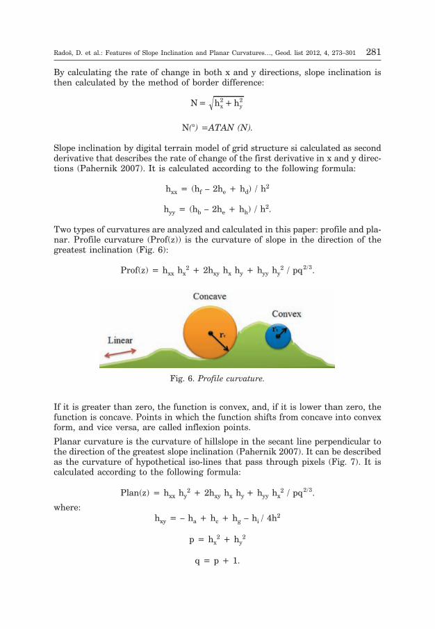
Two types of curvatures are analyzed and calculated in this paper: profile and pla-nar. Profile curvature (Prof(z)) is the curvature of slope in the direction of thegreatest inclination (Fig. 6):
Prof(z) = hxx hx2 + 2hxy hx hy + hyy hy
2 / pq2 3/ .
If it is greater than zero, the function is convex, and, if it is lower than zero, thefunction is concave. Points in which the function shifts from concave into convexform, and vice versa, are called inflexion points.
Planar curvature is the curvature of hillslope in the secant line perpendicular tothe direction of the greatest slope inclination (Pahernik 2007). It can be describedas the curvature of hypothetical iso-lines that pass through pixels (Fig. 7). It iscalculated according to the following formula:
Plan(z) = hxx hy2 + 2hxy hx hy + hyy hx
2 / pq2 3/ .
where:hxy = – ha + hc + hg – hi / 4h2
p = hx2 + hy
2
q = p + 1.
Radoš, D. et al.: Features of Slope Inclination and Planar Curvatures…, Geod. list 2012, 4, 273–301 281
Fig. 6. Profile curvature.
4. Results
4.1. The structure and spatial distribution of slope inclination with regardsto morphological units
From various data on structure and spatial distribution of hill side slopes inregards to morphological units (Fig. 8 and 9) it is noticeable that there are signifi-cant differences between individual morphological units. Inclinations of category0–2° are generally rare (1.25–14.55%). These categories are more frequent inareas of morphological units of Grabovica, Mesihovina, Ljubuša and Tomislav-grad hills (8.18–14.55%). Main reasons are: a) the fact that some of these morpho-logical units (Ljubuša and Grabovica) feature a great deal of areas that are basedon limestone rocks and were reshaped by a long process of corrosion on a karstplain, which itself has interchangeable concave (karst dolines, uvalas, collapseddolines) and convex shapes (heights or smaller areas between karst depressions);and b) on other morphological units (Tomislavgrad hills and Mesihovina) softenTertiary sediments (marl) are most prominent, and since they are verysusceptible to denudation and sedimentation of colluvial and diluvial material,the lower parts of this area (especially the trasition towards Duvanjsko polje)feature smaller slope inclinations.
Inclination category of 2–5° is the most prominent on areas of the same morpholo-gical units as the previous one. The reasons for that are basically the same as forthe previous category, but the intensity of various sorts of morphological processesis stronger. That means that there have been more intense karst processes in areasof Ljubuša and Grabovica which feature slopes of this category, which has resultedin greater differences between concave and convex shapes. This has probably beenenhanced by tectonics, i.e. the existence of several smaller faults and other structu-ral discontinuities that are important for local terrain, and which coincide withareas of this category (Fig. 2 and 9). In areas of Tomislavgrad hills and Mesihovina,
282 Radoš, D. et al.: Features of Slope Inclination and Planar Curvatures…, Geod. list 2012, 4, 273–301
Fig. 7. Planar curvature.
as well as those of previous category, due to a different lithological structure, thereare cases of different geomorphological processes, i.e. more intense denudation andsedimentation of hillslope material, mostly at lower levels of hill sides.
Categories of inclination of 5–12° is the most dominant (relative to other catego-ries) in areas of morphological units of Ljubuša and Tomislavgrad hills (48.67 and42.83%), Grabovica, Mesihovina and Jelovaèa (39.09, 33.15 and 32.77%) (Fig. 8).This category also features the duality of geomorphological processes, depending onits lithological structure. The difference is that those areas where limestone domi-nates (Ljubuša, Grabovica) no longer feature mostly flat surface, but greater num-ber of homogenous surfaces of developed limestone hillslopes and heights (of largerdimensions), on which a combination of surface watercourses and swallow-holes ispresent, in addition to a significant effect of tectonics (main and auxiliary faultsand other structural discontinuities). All of this, combined with the effects of expo-sition, has an effect on vegetation characteristics and agricultural land types.
Categories of inclination of 12–32° are most frequent in areas of morphologicalunits of Tušnica and Vran (64.64 and 63.70%), Lib and Jelovaèa (55.53% and51.05%), and Mesihovina (37.62%) (Fig. 8). Other morphological units featurethese categories to a much lesser degree, especially in relation to category of 5–12°(Fig. 8). Hillslopes within this category are dominant on peripheral sides of lime-
Radoš, D. et al.: Features of Slope Inclination and Planar Curvatures…, Geod. list 2012, 4, 273–301 283
Fig. 8. Structure of hillslopes in morphological units.
stone flats (e.g. NE slope of Grabovica, which borders Duvanjsko polje by a steepslope, Fig. 9), sides of deep ravines and/or river or brook basins (e.g. a grid of ravi-nes, brook and river basins of Tušnica and Mesihovina; peripheral sides of Šujicacanyon in the bordering area between morphological units of Jelovaèa and Ljubu-ša), as well as slopes in higher parts of the aforementioned morphological units(Tušnica, Jelovaèa, highest parts of Lib). Occasionally, they can be found at lowerlevels of hillslopes, especially on those areas which are preconditioned to tectonicdislocations (e.g. lower parts of NE hillslope of Lib, near the fault on the contactarea of Lib and SW hillslope of Vran Mountain, Fig. 2 and 9).
Slope inclinations of category 32–55° are present by a very small ratio and aremostly present within morphological units of Tušnica and Lib (5.10% and 4.06%)(Fig. 8). The main reason for that are morphological and morphostructural cha-racteristics of these two morphological units, i.e. a greater proportion of areas ofhigh altitude, significant terrain dynamics and frequent tectonic dislocations(faults, overthrusts and crusts) (Fig. 2 and 9).
Slope inclinations of >55° are present by an extremely low ratio, only appearingin the morphological unit of Lib, near the tectonically preconditioned steep hill si-des of its central ledge.
284 Radoš, D. et al.: Features of Slope Inclination and Planar Curvatures…, Geod. list 2012, 4, 273–301
Fig. 9. Spatial distribution of hillslopes in morphological units (1 = Vran, 2 = Ljubuša,3 = Jelovaèa, 4 = Tušnica, 5 = Tomislavgrad hills, 6 = Grabovica, 7 = Mesiho-vina, 8 = Lib).
4.2. The structure and spatial distribution of slope curvature with regardsto morphological units
The notion of slope curvature refers to its geometric shape. The shape of the slopeis a result of denudation (sheet washing, soil creeping, flowing, dispersion andcollapsing) and accumulation, which are caused by endogenous and exogenousgeomorphological factors.
The differentiation between concave, convex and straight slopes, made by Savigear(1952, 1956) and further developed by Young (1964, 1971), is still the basis ofslope shape analysis.
Convex slopes (or parts of slopes) are indicators of positive tectonic movements(uplift) connected with domination of denudational processes in which the inten-sity increases with the increase of slope inclination. Straight or linear slopes (orparts of them) point to spatially balanced tectonic and denudational conditionswhich cause uniform movement of slope material down the slope, and, in along-term sense, cause parallel transgression of slope caused by denudation. Con-cave slopes (or parts of them) are indicators of negative tectonic movements(lowering) connected with an increased amount of accumulation and sedimenta-tion of slope material (Dikau et al. 2004).
4.2.1. Profile curvature of hillslopes
From the collected data on structure and spatial distribution of profile curvatureon the researched area (Fig. 10), it is visible that convex and concave hillslopesare the most dominant.
Radoš, D. et al.: Features of Slope Inclination and Planar Curvatures…, Geod. list 2012, 4, 273–301 285
Fig. 10. Structure of profile curvature in morphological units.
Between individual morphological units there is no significant difference in theproportion of convex and concave slopes, in contrast to linear slopes, which showa greater degree of variability.
Linear slopes are the most frequent within the morphological unit of Tomislav-grad hills (5.6%). By comparison of spatial distribution of slopes with profilecurvature (Fig. 11) and geological map (Fig. 2), a certain analogy is visiblebetween the direction of convex and concave slopes on one side and the directionof anticlines, synclines, fault lines and fronts of overthrusts and crusts. Thisconfirms the assumption about profile curvature as a reliable indicator ofdirections of tectonic movements (whether positive or negative). Areas with linearprofile slopes are most often outside of tectonically active zones (faults), or near
286 Radoš, D. et al.: Features of Slope Inclination and Planar Curvatures…, Geod. list 2012, 4, 273–301
Fig. 11. Spatial distribution of profile curvature in morphological units (1 = Vran,2 = Ljubuša, 3 = Jelovaèa, 4 = Tušnica, 5 = Tomislavgrad hills, 6 = Grabovi-ca, 7 = Mesihovina, 8 = Lib).
those faults which have a less accented activity, i.e. which do not feature anymajor dislocations.
4.2.2. Planar curvature of hillslopes
Planar curvature structure is similar to that of profile curvature, meaning thereis a certain degree of domination of convex and concave slopes, although thedifferences between their respective proportions are more accented within theindividual morphological units (Fig. 12). Those differences primarily becomenotable in morphological units of Tomislavgrad hills, Vran, Ljubuša, Tušnica andJelovaèa, where the domination of convex curvatures in comparison with concaveones is more apparent (Fig. 12 and 13). This type of situation hints at a relativelygreater importance of exogenous geomorphological processes of denudation thanthose of accumulation, as well as combined effects of endogenous and exogenousprocesses on the morphological shaping of the terrain. This means that theprocess of denudation on those morphological units, which feature the most signi-ficant differences, is additionally enhanced in certain areas by positive tectonicmovements.
Radoš, D. et al.: Features of Slope Inclination and Planar Curvatures…, Geod. list 2012, 4, 273–301 287
Fig. 12. Structure of planar curvature in morphological units.
4.2.3. Relation between types of profile and planar curvature of hillslopes
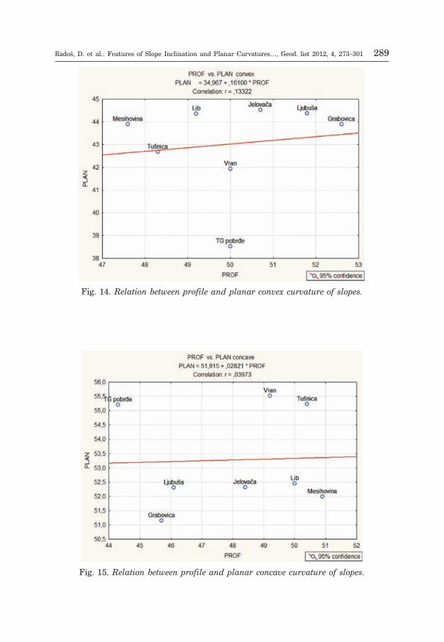
By analysis of the relation between profile and planar convex slopes of morpholo-gical units of the researched area it was concluded that there is no significant cor-relation between profile and planar convex and concave curvature, which is consi-stent with previous researches (Armstrong 1987, Parsons 1988). The coefficientof correlation between profile and planar convex curvature on the researched areais 0.13 (Fig. 14). Even less notable is the relation between profile and planar con-cave slopes (correlation coefficient is 0.04, Fig. 15). In contrast, the relation bet-ween profile and planar linear slopes show a significant positive relation (correla-tion coefficient is 0.83, Fig. 16), which is a result of nearly identical spatial distri-bution (Fig. 11 and 13).
288 Radoš, D. et al.: Features of Slope Inclination and Planar Curvatures…, Geod. list 2012, 4, 273–301
Fig. 13. Spatial distribution of planar curvature in morphological units (1 = Vran,2 = Ljubuša, 3 = Jelovaèa, 4 = Tušnica, 5 = Tomislavgrad hills, 6 = Grabovi-ca, 7 = Mesihovina, 8 = Lib).
Radoš, D. et al.: Features of Slope Inclination and Planar Curvatures…, Geod. list 2012, 4, 273–301 289
Fig. 14. Relation between profile and planar convex curvature of slopes.
Fig. 15. Relation between profile and planar concave curvature of slopes.
4.3. Comparative analysis of the relation between slope inclination and profileand planar curvature
4.3.1. Relation between slope inclination and types of profile curvature
4.3.1.1. Relation between slope inclination and profile convex curvature
Based on data on the relation between slope categories and slopes with planarconvex curvature in morphological units (Fig. 17), it is evident that there is anasymmetric distribution, i.e. domination of slope category 12–32° or 5–12° withinthe whole system. If the relation between slope inclination and profile convex cur-vature is observed with regard to morphological units, domination of slope cate-gory 12–32° is the most evident in units of Vran, Jelovaèa, Tušnica, Mesihovinaand Lib. Considering the level of that relation, within those five morphologicalunits the most prominent are Vran Vran (32.92%), Tušnica (32.40%) and, somew-hat less prominent, Lib (27.73%).
Within the remaining three units, the significance of slope category of 12–32° ismuch less evident, i.e. slope categories of 5–12° are the most dominant (Ljubuša25.32%, Tomislavgrad hills 22.29% and Grabovica 20.85%). Portions of other slo-pe categories are much lower, with the category of 2–5° somewhat prominent wit-hin the morphological unit of Tomislavgrad hills (12.84%).
290 Radoš, D. et al.: Features of Slope Inclination and Planar Curvatures…, Geod. list 2012, 4, 273–301
Fig. 16. Relation between profile and planar linear curvature of slopes.
4.3.1.2. Relation between slope inclination and profile concave curvature
The relation between categories of slope inclination and profile concave curvature showssimilar characteristics as the relation between inclination and profile convex curvature(asymmetry of distribution, i.e. domination of inclination category 12–32° and 5–12°), al-though, at the level of morphological units, there are evident differences (Fig. 18). They
Radoš, D. et al.: Features of Slope Inclination and Planar Curvatures…, Geod. list 2012, 4, 273–301 291
Fig. 17. Relation between various slope categories and profile convex curvature.
Fig. 18. Relation between slopes of various categories of inclinaton and profile concavecurvature.
primarily refer to the hierarchy of distribution of slope category of 12–32°. Altho-ugh the same morphological units seem to dominate, similar to convex curvature,their distribution according to the level of relation is somewhat different. Themost dominant morphological unit is Tušnica (32.03%), followed by Vran (30.6%)and Lib (27.64%).
The portion of category of 5–12° within few morphological units is more signifi-cant than that of category 12–32°. This primarily refers to units of Ljubuša(22.48%), Tomislavgrad hills (18.85%) and Grabovica (17.8%), with the distribu-tion nearly identical to that of convex curvature.
Portions of other categories of slope inclination are much smaller, with thecategory of 2–5° being somewhat prominent within Tomislavgrad hills(14.04%).
4.3.1.3. Relation between slope inclination and profile linear curvature
The structure of the relation between categories of slope inclination and profile li-near curvature shows an extremely asymmetric distribution (Fig. 19), i.e. the gre-atest portion of its value is concentrated within the category of 0–2°. Areas of pro-file linear curvature are characteristic in morphological units of Grabovica (8.3%),Mesihovina (6.94%) and Ljubuša (4.23%). Grabovica and Ljubuša, in particular,feature exquisite instances of profile linear slopes with inclinations up to 2°,which can be found in on parts of corrosion terrace of Podine (Ljubuša) and flatson higher altitudes somewhat farther away from Duvanjsko polje (Grabovica andLjubuša) (Fig. 11).
292 Radoš, D. et al.: Features of Slope Inclination and Planar Curvatures…, Geod. list 2012, 4, 273–301
Fig. 19. Relation between various categories of slope inclination and profile linearcurvature.
4.3.2. Relation between slope inclination and types of planar curvature
4.3.2.1. Relation between slope inclination and planar convex curvature
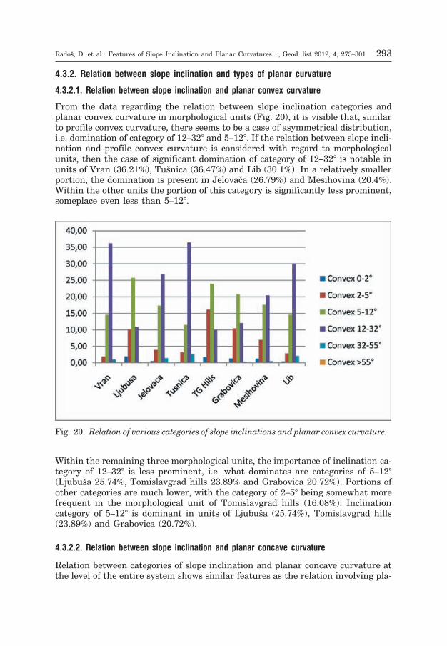
From the data regarding the relation between slope inclination categories andplanar convex curvature in morphological units (Fig. 20), it is visible that, similarto profile convex curvature, there seems to be a case of asymmetrical distribution,i.e. domination of category of 12–32° and 5–12°. If the relation between slope incli-nation and profile convex curvature is considered with regard to morphologicalunits, then the case of significant domination of category of 12–32° is notable inunits of Vran (36.21%), Tušnica (36.47%) and Lib (30.1%). In a relatively smallerportion, the domination is present in Jelovaèa (26.79%) and Mesihovina (20.4%).Within the other units the portion of this category is significantly less prominent,someplace even less than 5–12°.
Within the remaining three morphological units, the importance of inclination ca-tegory of 12–32° is less prominent, i.e. what dominates are categories of 5–12°(Ljubuša 25.74%, Tomislavgrad hills 23.89% and Grabovica 20.72%). Portions ofother categories are much lower, with the category of 2–5° being somewhat morefrequent in the morphological unit of Tomislavgrad hills (16.08%). Inclinationcategory of 5–12° is dominant in units of Ljubuša (25.74%), Tomislavgrad hills(23.89%) and Grabovica (20.72%).
4.3.2.2. Relation between slope inclination and planar concave curvature
Relation between categories of slope inclination and planar concave curvature atthe level of the entire system shows similar features as the relation involving pla-
Radoš, D. et al.: Features of Slope Inclination and Planar Curvatures…, Geod. list 2012, 4, 273–301 293
Fig. 20. Relation of various categories of slope inclinations and planar convex curvature.
nar convex curvature (asymmetrical distribution, i.e. domination of inclinationcategory of 12–32° and 5–12°), although, at the level of morphological units, thereare differences (Fig. 21). This primarily refers to the hierarchy of distribution ofslope inclination category of 12–32°; although, similar to convex curvature, samemorphological units dominate, their hierarchy is somewhat different. The mostdominant unit is Tušnica (27.68%), followed by Vran (27.11%), Lib (24.98%) andJelovaèa (23.7%).
Morphological units with feature the portion of category of 5–12° greater thanthat of 12–32° are Ljubuša (21.8%), Grabovica (17.53%) and Tomislavgrad hills(17.07%), with the different hierarchy than that of convex curvature.
Portions of other categories are significantly lower, the only exception being thecategory of 2–5° which is somewhat prominent in Tomislavgrad hills (11.09%).
4.3.2.3. Relation between slope inclination and planar linear curvature
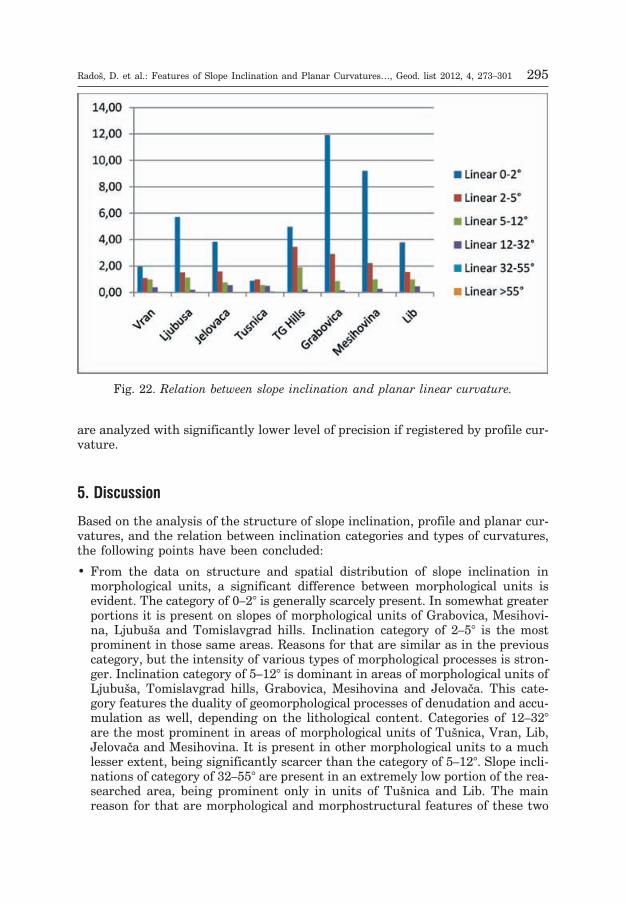
The structure of relation between categories of slope inclination and planar linearcurvature in morphological units shows, similar to profile linear curvature, extre-mely asymmetric distribution (Fig. 22), i.e. the greatest portion of values is con-centrated within the category of 0–2°. The greater portion of slopes with profile li-near curvature is characteristic in morphological units of Grabovica (11.91%),Mesihovina (9.21%) and Ljubuša (5.71%). Notable is the fact that, in all the cases,portions of the category of 0–2° are greater than in the examples of profile linearcurvature, which further adds to the fact that planar curvature is a better indica-tor of exogeomorphological forms and processes; specifically, this applies to conca-ve terrain forms (bottoms of ravines, valleys, karst sinkholes, basins etc.) which
294 Radoš, D. et al.: Features of Slope Inclination and Planar Curvatures…, Geod. list 2012, 4, 273–301
Fig. 21. Relation between slope inclination and planar concave curvature.
are analyzed with significantly lower level of precision if registered by profile cur-vature.
5. Discussion
Based on the analysis of the structure of slope inclination, profile and planar cur-vatures, and the relation between inclination categories and types of curvatures,the following points have been concluded:
• From the data on structure and spatial distribution of slope inclination inmorphological units, a significant difference between morphological units isevident. The category of 0–2° is generally scarcely present. In somewhat greaterportions it is present on slopes of morphological units of Grabovica, Mesihovi-na, Ljubuša and Tomislavgrad hills. Inclination category of 2–5° is the mostprominent in those same areas. Reasons for that are similar as in the previouscategory, but the intensity of various types of morphological processes is stron-ger. Inclination category of 5–12° is dominant in areas of morphological units ofLjubuša, Tomislavgrad hills, Grabovica, Mesihovina and Jelovaèa. This cate-gory features the duality of geomorphological processes of denudation and accu-mulation as well, depending on the lithological content. Categories of 12–32°are the most prominent in areas of morphological units of Tušnica, Vran, Lib,Jelovaèa and Mesihovina. It is present in other morphological units to a muchlesser extent, being significantly scarcer than the category of 5–12°. Slope incli-nations of category of 32–55° are present in an extremely low portion of the rea-searched area, being prominent only in units of Tušnica and Lib. The mainreason for that are morphological and morphostructural features of these two
Radoš, D. et al.: Features of Slope Inclination and Planar Curvatures…, Geod. list 2012, 4, 273–301 295
Fig. 22. Relation between slope inclination and planar linear curvature.
units, i.e. a greater portion of areas at high altitudes, exceptional terrain dyna-mics and frequent tectonic dislocations (faults, overthrusts and crusts). Inclina-tions greater than 55° are present in an extremely low portion, and only in themorphological unit of Lib, near the tectonically conditioned steep hillslopes atthe middle ledge.
• Spatial distribution of slopes with various types of profile curvature showssignificant parallelism with the directions of tectonic lines. These slopes areoften grouped in larger areals with feature block structure or are stretchedalong a tectonic line. This primarily refers to parallelism of types of curvature,i.e. the alternation of convex and concave parts of slopes within blocks (Tušni-ca, Lib, Tomislavgrad hills) or elongated areals (Ljubuša, Grabovica, Jelovaèa,Lib). Correlation with the geological map shows that dislocations (faults,overthrusts, crusts) are present along the bordering elongated areas, at thecontact of convex and concave areals. This is further confirmed by the distribu-tion of slope inclination. Namely, in all of these instances, there is a greaterportion of relatively steeper inclination categories (especially those of 12–32°),which additionally indicates the activity of neotectonic processes within the re-searched area.
• Unlike profile curvature, where elongated and block structure dominates theareal, those areas with various types of planar curvature feature dominantareals that are smaller in size (degradation) and which correspond with thedistribution of concave and convex terrain forms (ravines and ledges, or karstdepressions and mid-spaces). Greater degree of size degradation is notablewithin morphological units which have limestone as their basis, and whichfeature spacious flats covered by karst sinkholes and basins (Grabovica, Ljubu-ša, parts of Lib).
• A more detailed analysis of relations between individual inclination categoriesand types of profile curvatures, as indicators of the intensity and characteri-stics of neotectonic processes, has shown that these processes are the most pro-minent in the morphological units of Vran, Tušnica, Lib, Jelovaèa and Mesiho-vina (the greatest portions of convex and concave slopes and inclination catego-ries of 12–32°, parallelism with tectonic lines), and not so prominent othermorphological units (Ljubuša, Tomislavgrad hills and Grabovica) which featuredominant inclination of 5–12° and less parallelism with tectonic lines. Linearslopes are present in a much smaller portion, with the inclination category of0–2° being dominant, mostly within the morphological unit of Grabovica andMesihovina. In the unit of Tomislavgrad hills the situation is somewhat morecomplex, i.e. there is a balanced portion of slopes with inclination of 0–2° and2–5°. That is a result of a specific lithological content (marl being dominant)which enabled a significant process of sedimentation in lower parts of hills, andwhich affected the shape of smoother slopes with inclination category of 2–5°.
• The analysis of relation between inclination category and types of planar curva-ture shows similarities, but also differences. Similarities are most evident inthe fact that most morphological units are very much the same (having occasio-nally different distribution), considering the hierarchy of domination ofmorphometric indicators. Differences are mostly evident in spatial distributionand structure of slopes with planar curvature. On both convex and concave
296 Radoš, D. et al.: Features of Slope Inclination and Planar Curvatures…, Geod. list 2012, 4, 273–301
slopes the dominant category is that of 12–32° in morphological units of Tušni-ca, Vran, Lib and Jelovaèa, which indicates a greater degree of intensity andcomplementarity of destructive processes of denudation on one side and accu-mulation on the other side, compared to other morphological units. Comparisonwith spatial distribution of slopes with profile convex and concave curvatureindicates a similar hierarchical order of slope inclinations in categories of12–32°, which indicates a combined effect of endogenous and exogenous pro-cesses. Exogenous geomorphological processes are of relatively lower intensityin morphological units of Ljubuša and Grabovica, which is a result of mainlylimestone-based structure (domination of karstic corrosion). There is a specificsituation within the morphological unit of Tomislavgrad hills. Namely, due toprominence of softer rock types in its base (Miocene marl), the intensity ofdenudation and accumulation causes a decrease in the level of inclination ofthose areas which are subject to denudation, and an increase in inclinationlevel in those areas with intensive sedimentation, which is also indicated bydata on slope structure (although the category of 12–32° is dominant, arelatively high portion of category of 5–12° is present nevertheless).
• Considering the relation between profile and planar curvature, field researchconfirms the result of digital model less suggestively (Parsons 1988), i.e. thereis no signifying relation between profile and planar curvature, especially onthose places which feature sheet washing more than soil creeping. Someconnection can exist only in local instances. An important notion for predictionof slope-related processes based on planar curvature, according to someauthors, is most notable in cases of sheet washing (Armstrong 1987, Parsons1988). Some other researchers have also shown a positive but weak correlationbetween planar and profile curvature (Evans and Cox 1999).
Data obtained from the analysis of types of profile and planar curvature confirmthe results from previous researches, i.e. a weak correlation between planar andprofile curvature. This is important because the analysis was conducted on arelatively broad area, which enables generalization of previous results that wereof local importance, i.e. obtained by analyzing narrow areas.
A great number of researches confirmed that the relation of slope inclination andcurvature, together with lithological content, affect the slope-related processes(Carson and Kirkby 1972, Young 1971, Parsons 1988, Khanchoul and Altschul2008), and, consequentially, the shape of a slope. This relation is implicitly intro-duced in some models of slope profile development (Kirkby 1985).
6. Conclusion
Quantitative-geomorphological research of slope inclination and curvature are ofgreat practical importance, since the shape of a slope has a significant effect onthe distribution of surface and underground water, and, by extension, the move-ment of various masses (Sidle et. al. 1985). E.g. on a concave slope or part of suchslope there will be a concentration of underground water (basins and ravines),which results in water saturation of local ground, and hence an increased proba-bility of landslide. On a concave slope or a part of it, a layer of ground (i.e. a cover
Radoš, D. et al.: Features of Slope Inclination and Planar Curvatures…, Geod. list 2012, 4, 273–301 297
which consists of non-consolidated or poorly consolidated material, residual ortransported from someplace else) can be twice the thick than on a convex one,which makes the slope more susceptible to processes of movement of mass. Slopeinclination, shape and location of hillslope play a significant role in determiningthe growth and development of vegetation, especially forests. At higher levels ofhillslopes and their steeper parts, the loss of nutrients from the ground can besignificant and water flows more intense, which results in a thinner layer of soil.Convex slopes are dryer, soil nutrients are scarce and the volume of soil is de-creased. Concave slopes are more humid and feature soils richer in nutrients andless pronounced derrasion, which contributes to better conditions for the growthand development of forest vegetation.
References
Ackermann, F. (1994): Digital Elevation Models – Techniques and Application, QualityStandards, Development, Proceedings of the Symposium Mapping and GeographicInformation Systems, ISPRS, USA, Vol. 30, 421–432.
Armstrong, A. C. (1987): Slopes, boundary conditions and the development ofconvexo-concave forms – some numerical experiments, Earth Surface Processesand Landforms, Vol. 12, 17–30.
Burrough, P. A., McDonell, R. A. (1998): Principles of Geographical InformationSystems, Oxford University Press, New York.
Carson, M. A., Kirkby, M. J. (1972): Hillslope form and process, Cambrridge Univ.Press, 475 p.
Èièiæ, S. (2002): Geološki sastav i tektonika BiH, Earth Science Institute, Sarajevo.
De Oliveira, M. A. (1990): Slope geometry and gully erosion development: Bananal, São
Paulo, Brazil. Z. Geomorph. N. F., 34/4, 423–434.
Dietrich, W. E., Wilson, C. J., Montgomery, D. R., McKean, J. (1993): Analysis oferosion thresholds, channel networks and landscapes morphology using a digitalterrain model, J. Geol., 101, 259–278.
Dikau, R. (1989): The application of a digital relief model to landform analysis in geo-morphology, J. Raper, Editor, Three Dimensional Applications in Geographic Infor-mation Systems, Taylor and Francis, Chichester, 51–77.
Dikau, R., Rasemann, S., Schmidt, J. (2004): Hillslope Form, In: Goudie, A.: Encyclope-dia of Geomorphology, Vol. 1, Routledge, London, 516–521.
Di Stefano, C., Ferro, V., Porto, P., Tusa, G. (2000): Slope curvature influence on soilerosion and deposition processes, Water Resources Research, Vol. 36/2, 607–617.
Evans, I. S. (1972): General geomorphometry, derivatives of altitude, and descriptivestatistics, Spatial Analysis in Geomorphology, Methuen, London.
Evans, I. S. (1980): An integrated system for terrain analysis for slope mapping,Zeitschrift für Geomorphologie, 36, 274–295.
Evans, I. S., Cox, N. J. (1999): Relations between land surface properties: Altitude,slope and curvature, Process Modelling and Landform Evolution, Editor: StefanHergarten, Horst J. Neugebauer, Lecture Notes in Earth Sciences, Vol. 78, 13–45.
298 Radoš, D. et al.: Features of Slope Inclination and Planar Curvatures…, Geod. list 2012, 4, 273–301
Franklin, S. E. (1987): Geomorphometric processing of digital elevation models,Computers & Geosciences, Vol. 13, Issue 6, 603–609.
Ganas, A., Pavlides, S., Karastathis, V. (2005): DEM-based morphometry of range-frontescarpments in Attica, central Greece, and its relation to fault slip rates, Geomor-phology, 65, 301–319.
García Rodriguez, J. L., Giménez Suárez, M. C. (2010): Comparison of mathematicalalgorithms for determining the slope angle in GIS environment, Aqua-LAC, Vol.2/2, 78–82.
Goncalves, J. A., Oliveira, A. M. (2004): Accuracy analysis of DEMS derived fromASTER imagery, ISPRS XX, Istanbul,Turkey.
Heerdegen, R. G., Beran, M. A. (1982): Quantifying Source Areas through Land SurfaceCurvature and Shape, Journal of Hydrology, 57, 359–373.
Hengl, T., Gruber, S., Shrestha, D. P. (2003): Digital Terrain Analysis in ILWIS, Digitalmanuscripts, International Institute for Geo-information Science and Earth Obser-vation, Enschede, Netherlands.
Hickey, R., Smith, A., Jankowski, P. (1994): Slope Length Calculations from a DEMwithin Arc/Info Grid, Comput. Environ. and Urban Systems, Vol. 18, 365–380.
Horn, B. K. P. (1981): Hill Shading and the Reflectance Map, Proc. IEEE, Vol. 69, No. 1,14–47.
Huggel, C., Schneider, D., Julio Miranda, P., Delgado Granados, H., Kaab, A. (2008):Evaluation of ASTER and SRTM DEM data for lahar modeling: a case study onlahars from Popocatepetl ’Volcano, Mexico, J. Volcanol. Geoth. Res., 170, 99–110.
Jordan, G., Csillag, G. (2001): Digital terrain modelling for morphotectonic analysis: AGIS framework, Ed. by H. OHMORI: DEM-s and Geomorphology, Special Publica-tion of the Geographic Information Systems Association, Nihon University, Tokyo,60–61.
Khanchoul, K., Altschul, R. (2008): The Relationship Between Lithology and Slope Mor-phology in the Tucson Mountains, Arizona, Anuário do Instituto de Geociências,
Vol. 31, No. 1, 30–42.
Kirkby, M. J. (1985): A model for the evolution of regolith-mantled slopes, In: Models inGeomorphology, ed. M. J. Woldenberg, Allen and Unwin, Winchester, Massachusets,213–237.
Li, Z., Zhu, Q., Gold, C. (2005): Digital Terrain Modeling, CRC Press, London.
Lee, J., Heap, A. D. (2008): A review of spatial interpolation methods for environmentalscientists, Technical Report GeoCat # 68229, Australian government.
Loziæ, S. (2001): Multivariate Approach to Relief Classification and Typology – theExample of North – Western Croatia, Acta Geographica Croatica, Vol. 35, 19–42.
Moore, I. D., Grayson, R. B., Landson, A. R. (1991): Digital Terrain Modelling: A Reviewof Hydrological, Geomorphological, and Biological Applications, HydrologicalProcesses, 5, 3–30.
Moore, I. D., Lewis, A., Gallant, J. C. (1993): Terrain attributes: estimation methodsand scale effects, In: A. J. Jakeman, M. B. Beck, M. J. McAleer (eds.), ModelingChange in Environmental Systems, New York: John Wiley and Sons, 189–214.
Ohlmacher, G. C. (2007): Plan curvature and landslide probability in regions dominatedby earth flows and earth slides, Engineering Geology, Vol. 91, Issues 2–4, 117–134.
Radoš, D. et al.: Features of Slope Inclination and Planar Curvatures…, Geod. list 2012, 4, 273–301 299
Olaya, V. (2009): Basic land surface parameters, Eds. T. Hengl and H. I. Reuter: Geo-morphometry – Concepts, Software, Applications, Developments in Soil Science,Elsevier, Vol. 33, 141–169.
Pahernik, M. (2007): Digital Analysis of the Slopes of Rab Island, Geoadria, Hrvatskogeografsko društvo – Zadar, Zadar, Vol. 12, 3–22.
Papeš, J. (1985): Geologija jugozapadne Bosne (disertacija), Posebno izdanje geološkogglasnika, knjiga XIX, Sarajevo.
Parsons, A. J. (1988): Hillslope form, Routledge, 212 p.
Pike, R. J., Evans, I. S., Hengl, T. (2009): Geomorphometry: A Brief Guide, Geomorpho-metry – Concepts, Software, Applications, Elsevier, Amsterdam, Oxford, 3–30.
Rieke-Zapp, D. H., Nearing, M. A. (2005): Slope Shape Effects on Erosion: A LaboratoryStudy, Soil Sci. Soc. Am. J., Vol. 69, 1463–1471, Soil & Water Management andConservation, doi:10.2136/sssaj2005.0015.
Roering, J. J., Kirchner, J. W., Dietrich, W. E. (1999): Evidence for nonlinear, diffusivesediment transport on hillslopes and implicetions for landscape morphology, WaterResources Research, Vol. 35/3, 853–870.
Savigear, R. A. G. (1952): Some observations on slope development in South Wales,Trans. and Papers IBG, 18, 31–51.
Savigear, R. A. G. (1956): Techniques and terminology in the investigation of slopeforms, Premier Rapport de la Commission pour L’Etude des Versants, Union Geo-graphique Internationale, 66–75.
Sidle, R. C., Pearce, A. J., O’Loughlin, C. L. (1985): Hillslope Stability and LandUse, Water Resour. Monogr. Ser., Vol. 11, 140 pp., AGU, Washington, D. C.,doi:10.1029/WM011.
Smith, M. J., Clark, C. D. (2005): Methods for visualisation of high resolution digital ele-vation models for landform mapping, Earth Surface Processes and Landforms,30/7, 885–900.
Tarboton, D. G. (1997): A New Method for the Determination of Flow Directions andContributing Areas in Grid Digital Elevation Models, Water Resources Research,33/2, 309–319.
Thorne, C. R., Zevenbergen, L. W., Burt, T. P., Butcher, D. P. (1987): Terrain analysisfor quantitative description of zero-order basins, Erosion and Sedimentation in thePacific Rim, Proceedings of the Corvallis Symposium, IAHS Publ., 165, 121–130.
Travis, M. R., Elsner, G. H., Iverson, W. D., Johnson, C. G. (1975): VIEWIT: computa-tion of seen areas, slope, and aspect for land-use planning, USDA F. S. Gen. Tech.Rep. PSW-11/1975, 70 p., Berkeley, California, U.S.A.
Weibel, R., Heller, M. (1991): Digital Terrain Modeling, In: Maguire, D. J., Goodchild,M. F. and Rhind, D. W. (eds.), Geographical Information Systems: Principles andApplications, London, Longman, 269–297.
Young, A. (1971): Slope profile analysis: The system of best units, Brunsden, D. (ed.),Slopes Form and Process, Inst. Br. Geog. Spec. Publ., No. 3, 1–13.
Zeverbergen, L. W., Thorne, C. R. (1987): Quantitative Analysis of Land Surface Topo-graphy, Earth Surface Processes and Landforms, 12, 47–56.
300 Radoš, D. et al.: Features of Slope Inclination and Planar Curvatures…, Geod. list 2012, 4, 273–301
Znaèajke nagiba i ravninske zakrivljenosti širegpodruèja Duvanjskog polja
SA�ETAK. U ovom su radu analizirane, kvantitativne geomorfološke znaèajke (na-gibi padina, profil i ravninska zakrivljenost) planinskoga rubnog podruèja Duvanj-skog polja. Na oblikovanje ovoga podruèja utjecalo je niz prirodnih i društvenihutjecaja tijekom geneze i evolucije reljefa. Cilj je ovog istra�ivanja analiza kvantita-tivnih obilje�ja nagiba padina i zakrivljenosti morfoloških obilje�ja šireg podruèjaDuvanjskog polja, tumaèenje rezultata i sinteze. Moguæ je detaljniji uvid u znaèajkenagiba i odvijenih procesa, a moguæe je postiæi i vrednovanje prirodno dominantnihgeomorfoloških procesa. Tijekom istra�ivanja posebna je pa�nja posveæena detaljnojgeomorfometrijskoj analizi u GIS okru�enju, na temelju digitalnog modela reljefa.Analiza je provedena u nekoliko faza: 1. komparativna analiza karakteristika nagi-ba temeljena na morfološkim obilje�jima, 2. komparativna analiza zakrivljenosti na-giba i 3. analiza odnosa izmeðu nagiba i znaèajki zakrivljenosti. Sinteza ukljuèujeinterpretaciju dobivenih rezultata u širem kontekstu odnosa izmeðu morfometrijskihznaèajki i strukturno/litoloških znaèajki morfoloških jedinica.