CONNECTION February 2014 Blacklands Corridor The Blacklands Corridor Feasibility Study is an ongoing assessment of transportaon needs in a wide area from IH 30 in Greenville to the President George Bush Turnpike in Garland. The study area stretches from US 380 in the north to IH 30 in the south and includes porons of Collin, Dallas, Hunt, and Rockwall counes. The North Central Texas Council of Governments (NCTCOG) is leading the feasibility study which is evaluang the need for transportaon improvements in the study corridor and idenfying potenal projects which could enhance local and regional access, manage congeson, address safety, and integrate with the regional transportaon system. This analysis will determine if there is a demonstrated need for projects based on current and projected congeson levels in this growing part of North Texas. Then, if a need is demonstrated, the study will proceed with the development of conceptual transportaon improvements. The mulmodal nature of this analysis will examine improvements to exisng arterial and freeway corridors, development of new or enhanced transit opons, idenficaon of operaonal changes to improve the exisng transportaon system, and the construcon of new transportaon facilies. The analysis will document potenal impacts to the natural and built environments and to exisng and planned transportaon corridors. Potenal benefits and impacts to property owners, residents, and businesses in the corridor will also be addressed. The opons under evaluaon fall into several categories. Transportaon Systems Management (TSM) Projects in this category use operaonal strategies to improve the capacity of the exisng transportaon system. Candidate TSM projects could include beer synchronizaon of traffic signals along key routes, idenfying locaons for the development of park‐and‐ride lots, installing dynamic message signs on IH 30 to alert drivers of condions, and instung lane restricons for trucks on IH 30. Bicycle/Pedestrian Facilies The examinaon of bicycle and pedestrian facilies will include a review of all local and regional plans, including NCTCOG’s Planners Studying Range of Transportaon Opons, Impacts Connued on page 2 Register Now for February Telephone Town Hall NCTCOG will host a telephone town hall on Thursday, Feb. 20, to share a brief update about study progress and answer quesons from the public. Parcipants must register their phone numbers in advance at www.nctcog.org/townhall or call 817‐608‐2335 before Feb. 19 at 6 pm. NCTCOG will then call all registered phone numbers on Feb. 20 at 6 pm. Following the telephone town hall, an audio recording will be posted at www.nctcog.org/blacklands. Save the Date: Telephone Town Hall Feb. 20 Thursday, Feb. 20, 2014 at 6 pm See arcle below. Public Meeng March 20 in Greenville Thursday, March 20, 2014 Fletcher Warren Civic Center 5501 S. Business Hwy. 69 Greenville, TX 75402 5:30 pm Open House 6:00 pm Presentaon & Public Comments (A video recording will be posted at www.nctcog.org/blacklands aſter the meeng.) 7:00 pm Open House Residents, elected officials, business leaders, and all individuals interested are invited to an open house and public meeng to learn about work completed to date in studying transportaon in the corridor as well as what to expect in the coming months. For special accommodaons due to a disability or language translaon, call 817‐608‐2335 or email [email protected] at least 72 hours prior to the meeng. Reasonable accommodaons will be made. Para ajustes especiales por discapacidad o para interpretación de idiomas, llame al 817‐608‐2335 o por email: [email protected] con 72 horas (mín‐ imo) previas a la junta. Se harán las adaptaciones razonables.
Transcript
CONNECTION
February 2014
Blacklands Corridor
The Blacklands Corridor Feasibility Study isan ongoing assessment of transportationneeds in a wide area from IH 30 inGreenville to the President George BushTurnpike in Garland. The study areastretches from US 380 in the north to IH 30in the south and includes portions of Collin,Dallas, Hunt, and Rockwall counties.
The North Central Texas Council of Governments (NCTCOG) is leading the feasibility study which is evaluating theneed for transportation improvements inthe study corridor and identifying potentialprojects which could enhance local and regional access, manage congestion, address safety, and integrate with the regional transportation system. This analysiswill determine if there is a demonstratedneed for projects based on current and projected congestion levels in this growing part of North Texas. Then, if a needis demonstrated, the study will proceedwith the development of conceptual transportation improvements.
The multimodal nature of this analysis willexamine improvements to existing arterialand freeway corridors, development of newor enhanced transit options, identification
of operational changes to improve the existing transportation system, and the construction of new transportation facilities.The analysis will document potential impacts to the natural and built environments and to existing and plannedtransportation corridors. Potential benefitsand impacts to property owners, residents,and businesses in the corridor will also beaddressed. The options under evaluation fallinto several categories.
Transportation Systems Management (TSM)Projects in this category use operationalstrategies to improve the capacity of the existing transportation system. CandidateTSM projects could include better synchronization of traffic signals along keyroutes, identifying locations for the development of park‐and‐ride lots, installingdynamic message signs on IH 30 to alertdrivers of conditions, and instituting lane restrictions for trucks on IH 30.
Bicycle/Pedestrian FacilitiesThe examination of bicycle and pedestrianfacilities will include a review of all localand regional plans, including NCTCOG’s
Planners Studying Range of Transportation Options, Impacts
Continued on page 2
Register Now for FebruaryTelephone Town Hall
NCTCOG will host a telephone town hall on Thursday, Feb. 20, to share abrief update about study progress and answer questions from the public. Participants must register their phone numbers in advance atwww.nctcog.org/townhall or call 817‐608‐2335 before Feb. 19 at 6 pm.NCTCOG will then call all registered phone numbers on Feb. 20 at 6 pm.Following the telephone town hall, an audio recording will be posted atwww.nctcog.org/blacklands.
Save the Date:
Telephone Town Hall Feb. 20
Thursday, Feb. 20, 2014 at 6 pmSee article below.
Public Meeting March 20 in Greenville
Thursday, March 20, 2014Fletcher Warren Civic Center5501 S. Business Hwy. 69Greenville, TX 75402
5:30 pmOpen House
6:00 pmPresentation & Public Comments(A video recording will be posted atwww.nctcog.org/blacklands afterthe meeting.)
7:00 pmOpen House
Residents, elected officials, business leaders, and all individualsinterested are invited to an openhouse and public meeting to learnabout work completed to date instudying transportation in the corridor as well as what to expectin the coming months.
For special accommodations due to adisability or language translation, call 817‐608‐2335 or [email protected] at least 72 hoursprior to the meeting. Reasonable accommodations will be made. Paraajustes especiales por discapacidad opara interpretación de idiomas, llameal 817‐608‐2335 o por email:[email protected] con 72 horas (mín‐imo) previas a la junta. Se harán lasadaptaciones razonables.
Inside the Feasibility Study
Veloweb, a network of existing and plannedoff‐street, shared‐use paths (trails). Also, thestudy will evaluate the NETEX right of wayfor potential use as a trail and consider anyimpact this might have on preserving NETEXfor future transportation options, such ascommuter rail.
TransitTransit options to be evaluated will includerail and bus. The rail option will examine theextension of the proposed Cotton Belt commuter line from Plano east along theNETEX right of way. New bus infrastructurecould include a bus rapid transit service,possibly traveling in its own right of way orusing shoulder lanes.
Arterial RoadwaysThe existing thoroughfare plans for thecities and counties in the study area will becompiled to identify and evaluate new or expanded arterial roadways which couldprovide congestion relief. This analysis willinclude proposed widenings of existingroads, new connectivity, and intersection upgrades. In addition to roads already in thoroughfare plans, other strategic improvements may also be identified.
IH 30 Bottleneck ProjectsAnalyzing potential or expected bottleneckson IH 30 could reveal that strategic and relatively low‐cost improvements at key
locations may help manage congestion. Projects could include extended merginglanes around key entrances and exits; intersection improvements at frontageroads and cross‐streets; ramp modificationsat interchanges; and conversion of two‐wayfrontage roads to one‐way.
IH 30 ReconstructionIn addition to strategic bottlenecks, a moreexpansive widening of IH 30 throughout thestudy area will be examined. Options include the addition of general‐purposefreeway lanes, construction of tolled expresslanes to add capacity to free lanes, and construction of continuous frontage roads.
New Highway/Freeway/TollwayThe construction of a new location highway,freeway, or tollway in the study corridor willbe evaluated. The interaction of such a roadway with the proposed Collin CountyOuter Loop, State Highway 78, and otherplanned or existing roads will be analyzedalong with the availability of funding.
As the Blacklands Corridor Feasibility Studyprogresses, these conceptual alternativeswill be assessed more fully, with each beingcompared to the others and against a no‐build scenario to further evaluate theireffectiveness at accommodating trafficgrowth. Additionally, the practicality of theproposed alternatives and potential fundingsources will be assessed in developing recommendations, which could include arange of projects from these categories.
Continued from Front Page Take Short Online Surveys To Give InputTwo online surveys are available to help gather public input. Pleasevisit www.nctcog.org/blacklandsto take the brief, anonymous surveys. The first survey will helpplanners better understand residential and commercial development, and the second survey will gauge the effectivenessof study communications and identify public preferences for ongoing outreach efforts. If you donot have online access, please call817‐608‐2335 to request a papersurvey.
Public Meeting Recap:Study Area NeedsAlmost 100 people joined stafffrom NCTCOG and their consultants in the City of Nevada for a public meeting in November. Presenters discussed apreliminary analysis that indicatesa need to accommodate projectedincreases in traffic flow in thestudy area, particularly crossingthe lake area. Members of thepublic also commented on thestudy and potential alternativesunder review. The meetingagenda, presentation, and a videorecording are available atwww.nctcog.org/blacklands.
US 380Currently: 15,000Projected Volume: 50,000Growth: 35,000Percent Growth: 230%
SH 78Currently: 28,000Projected Volume: 66,000Growth: 38,000Percent Growth: 130%
SH 66Currently: 24,000Projected Volume: 42,000Growth: 18,000Percent Growth: 75%
IH 30Currently: 93,000Projected Volume: 154,000Growth: 61,000Percent Growth: 65%
West Tawako
Lavon Lake
LakeRay
Hubbard
±
Ellis
WiseHunt
Collin
DallasParker
Denton
Tarrant
Kaufman
JohnsonHood
Rockwall
Blacklands Corridor Study Area Projected Traffic Growth to 2035Legend
Study Area
Freeways/Tollways
Major Arterials
County Boundaries
September 25, 2013
0 2.5 5
Miles
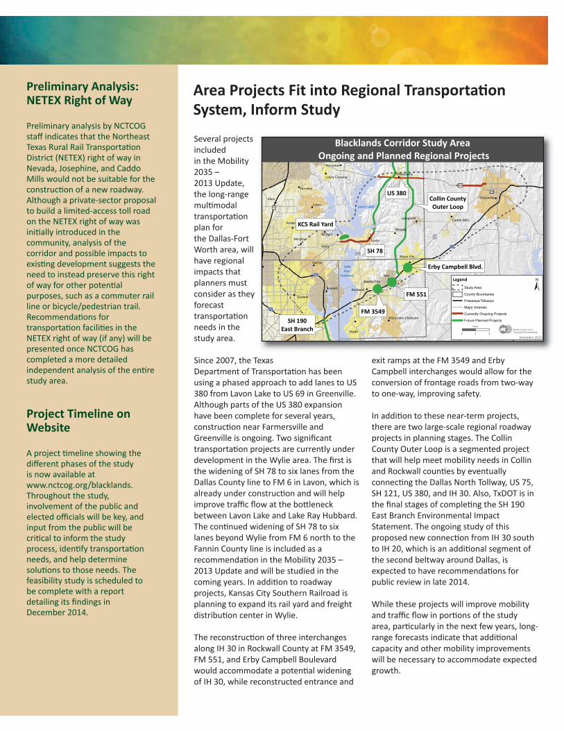
Several projectsincluded in the Mobility2035 – 2013 Update, the long‐rangemultimodal transportationplan for the Dallas‐FortWorth area, willhave regional impacts thatplanners must consider as theyforecast transportationneeds in thestudy area.
Since 2007, the Texas Department of Transportation has beenusing a phased approach to add lanes to US380 from Lavon Lake to US 69 in Greenville. Although parts of the US 380 expansionhave been complete for several years, construction near Farmersville andGreenville is ongoing. Two significant transportation projects are currently underdevelopment in the Wylie area. The first isthe widening of SH 78 to six lanes from theDallas County line to FM 6 in Lavon, which isalready under construction and will help improve traffic flow at the bottleneck between Lavon Lake and Lake Ray Hubbard.The continued widening of SH 78 to sixlanes beyond Wylie from FM 6 north to theFannin County line is included as a recommendation in the Mobility 2035 –2013 Update and will be studied in the coming years. In addition to roadway projects, Kansas City Southern Railroad isplanning to expand its rail yard and freightdistribution center in Wylie.
The reconstruction of three interchangesalong IH 30 in Rockwall County at FM 3549,FM 551, and Erby Campbell Boulevardwould accommodate a potential wideningof IH 30, while reconstructed entrance and
exit ramps at the FM 3549 and Erby Campbell interchanges would allow for theconversion of frontage roads from two‐wayto one‐way, improving safety.
In addition to these near‐term projects,there are two large‐scale regional roadway projects in planning stages. The CollinCounty Outer Loop is a segmented projectthat will help meet mobility needs in Collinand Rockwall counties by eventually connecting the Dallas North Tollway, US 75,SH 121, US 380, and IH 30. Also, TxDOT is inthe final stages of completing the SH 190East Branch Environmental Impact Statement. The ongoing study of this proposed new connection from IH 30 southto IH 20, which is an additional segment ofthe second beltway around Dallas, is expected to have recommendations for public review in late 2014.
While these projects will improve mobilityand traffic flow in portions of the studyarea, particularly in the next few years, long‐range forecasts indicate that additional capacity and other mobility improvementswill be necessary to accommodate expectedgrowth.
Area Projects Fit into Regional Transportation System, Inform Study
Preliminary Analysis:NETEX Right of Way
Preliminary analysis by NCTCOGstaff indicates that the NortheastTexas Rural Rail Transportation District (NETEX) right of way in Nevada, Josephine, and CaddoMills would not be suitable for theconstruction of a new roadway.Although a private‐sector proposalto build a limited‐access toll roadon the NETEX right of way was initially introduced in the community, analysis of the corridor and possible impacts toexisting development suggests theneed to instead preserve this rightof way for other potential purposes, such as a commuter railline or bicycle/pedestrian trail.Recommendations for transportation facilities in theNETEX right of way (if any) will be presented once NCTCOG has completed a more detailed independent analysis of the entirestudy area.
Project Timeline onWebsite
A project timeline showing the different phases of the study is now available atwww.nctcog.org/blacklands.Throughout the study, involvement of the public andelected officials will be key, andinput from the public will be critical to inform the studyprocess, identify transportationneeds, and help determine solutions to those needs. The feasibility study is scheduled to be complete with a report detailing its findings in December 2014.
!
!
!
!!
!
!
!
!
!
!
!
!
!
!
!
!
!
!
!
!
!
!!
!
!
!
!
!
!!
Collin CountyOuter Loop
US 380
KCS Rail Yard
SH 78
SH 190East Branch
FM 3549
FM 551
Erby Campbell Blvd.
Garland
Wylie
McKinney
Allen Greenville
Rockwall
n
Rowlett
Lucas
Heath
Sachse
Royse City
Fate
Parker
Fairview
Princeton
Murphy Lavon
McLendon-Chisholm
Caddo Mills
Farmersville
NevadaSt. Paul
Josephine
Lowry Crossing
West TaQuinlan
New Hope
Hawk Cove
Neylandville
Mobile City
Lavon Lake
LakeRay
Hubbard
Blacklands Corridor Study Area Ongoing and Planned Regional Projects
December 20130 2 4
Miles
±Legend
Study Area
County Boundaries
Freeways/Tollways
Major Arterials
Currently Ongoing Projects
Future Planned Projects
North Central Texas Council of GovernmentsP. O. Box 5888Arlington, TX 76005‐5888
Blacklands CorridorCONNECTION
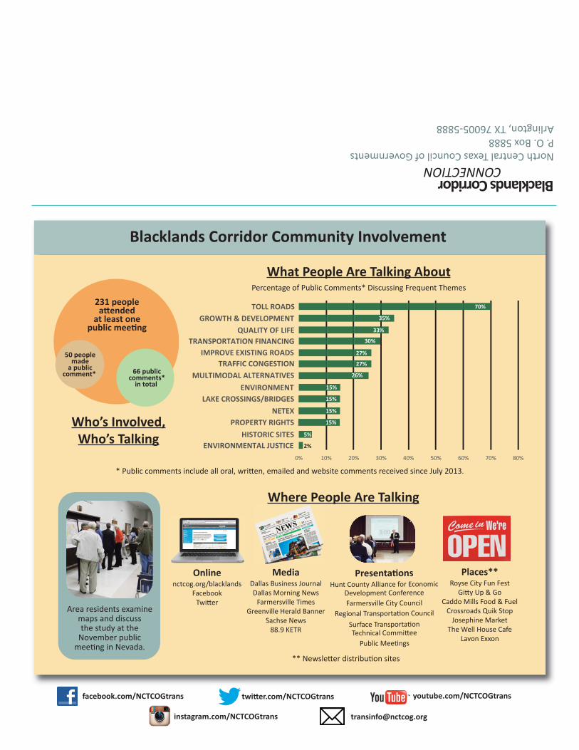
Blacklands Corridor Community Involvement
231 peoplea�ended
at least onepublic mee�ng
50 peoplemade
a publiccomment*
66 public
comments*in total
Who’s Involved,Who’s Talking
2%
5%
15%
26%
27%
27%
30%
33%
35%
70%
0% 10% 20% 30% 40% 50% 60% 70% 80%
TOLL ROADSGROWTH & DEVELOPMENT
QUALITY OF LIFETRANSPORTATION FINANCING
IMPROVE EXISTING ROADSTRAFFIC CONGESTION
MULTIMODAL ALTERNATIVESENVIRONMENT
HISTORIC SITESENVIRONMENTAL JUSTICE
15%
15%
15%
LAKE CROSSINGS/BRIDGES
PROPERTY RIGHTSNETEX
What People Are Talking AboutPercentage of Public Comments* Discussing Frequent Themes


![Netex | Gamification LT2016 [EN]](https://static.documents.pub/doc/80x56/58f037301a28ab9a578b456d/netex-gamification-lt2016-en.jpg)
![Netex learningApp | Presentation [En]](https://static.documents.pub/doc/80x56/5416085a8d7f722f6c8b4913/netex-learningapp-presentation-en.jpg)

![Netex learningSocial | Presentation [EN]](https://static.documents.pub/doc/80x56/55b41436bb61ebef558b474a/netex-learningsocial-presentation-en.jpg)

![Netex learningMaker | What's New v3.0 [En]](https://static.documents.pub/doc/80x56/5416091e8d7f72a26c8b467a/netex-learningmaker-whats-new-v30-en.jpg)
![Netex learningMaker | Author Guide v3.1 [En]](https://static.documents.pub/doc/80x56/541608688d7f72a26c8b4671/netex-learningmaker-author-guide-v31-en.jpg)
![Netex learningMaker | Video Template v2.2.2 [En]](https://static.documents.pub/doc/80x56/5416089c8d7f728a6c8b493a/netex-learningmaker-video-template-v222-en.jpg)

![Netex | Smart Content 2016 [EN]](https://static.documents.pub/doc/80x56/5879b4bd1a28ab6b2c8b6621/netex-smart-content-2016-en.jpg)
![Netex learningMaker | Author Manual v3.0 [Es]](https://static.documents.pub/doc/80x56/541608a68d7f72316c8b48fc/netex-learningmaker-author-manual-v30-es.jpg)

![Netex learningMaker | Presentation [En]](https://static.documents.pub/doc/80x56/541608058d7f72316c8b48f5/netex-learningmaker-presentation-en.jpg)
![Netex learningMaker | Author Manual v3.0 [En]](https://static.documents.pub/doc/80x56/541608ae8d7f722f6c8b4918/netex-learningmaker-author-manual-v30-en.jpg)

![Netex learningMaker | Dossier [En]](https://static.documents.pub/doc/80x56/541607f28d7f72336c8b493a/netex-learningmaker-dossier-en.jpg)

![Netex learningCentral | What's New v6.0 [EN]](https://static.documents.pub/doc/80x56/55a62def1a28ab746d8b4613/netex-learningcentral-whats-new-v60-en.jpg)