+ All Categories
Home > Documents > Fernandina Beach - UNITED STATES

Fernandina Beach - UNITED STATES

Date post: 03-Apr-2022
Category:
Upload: others
View: 3 times
Download: 0 times
Share this document with a friend
1
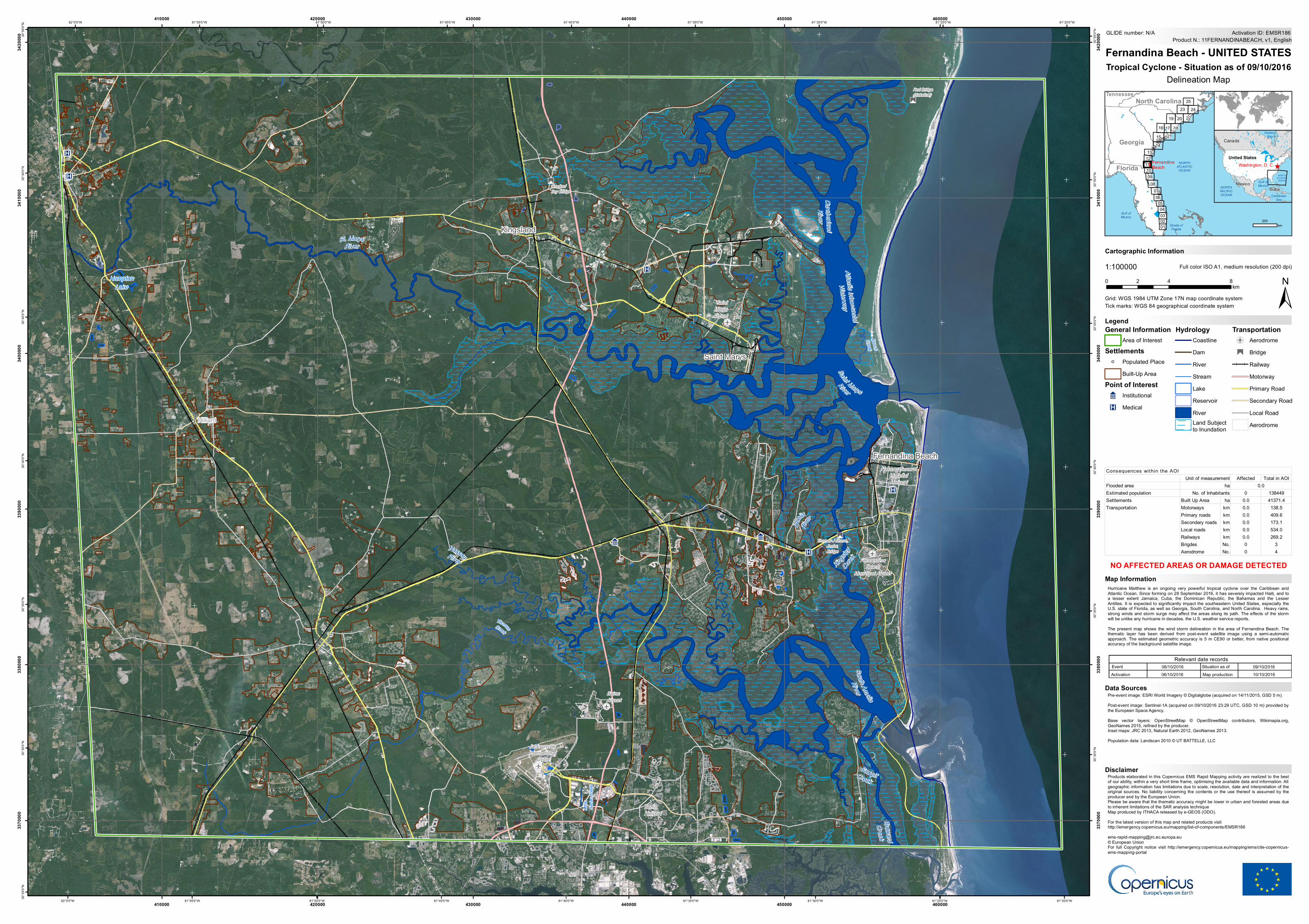
" £ " £ " £ ! r ! r ! r ! r ! ! ! ! ! 9 9 9 9 K K K K K K Hampton Lake Little Cedar Creek B e a c h C r e e k T h o m a s C r e e k Broward Creek K i n g s l e y C r e e k S a w p i t C r e e k A m e l i a R i v e r S a in t M a r y s R iv e r S o u t h A m el i a R i v e r Atlantic Intracoastal Waterway Cumberland River S t. M a r y s R i v e r N a s s a u R i v e r Thomas J Shave, Junior, Bridge Crooked Bay Bridge Red Bridge (historical) Berlin Heliport Nassau General Hospital Heliport Baine Airport Fernandina Beach Municipal Airport Jacksonville International Airport Saint Marys Airport Hilliard Kingsland Fernandina Beach Saint Marys 81°20'0"W 81°20'0"W 81°25'0"W 81°25'0"W 81°30'0"W 81°30'0"W 81°35'0"W 81°35'0"W 81°40'0"W 81°40'0"W 81°45'0"W 81°45'0"W 81°50'0"W 81°50'0"W 81°55'0"W 81°55'0"W 82°0'0"W 82°0'0"W 30°55'0"N 30°55'0"N 30°50'0"N 30°50'0"N 30°45'0"N 30°45'0"N 30°40'0"N 30°40'0"N 30°35'0"N 30°35'0"N 30°30'0"N 30°30'0"N 30°25'0"N 410000 410000 420000 420000 430000 430000 440000 440000 450000 450000 460000 460000 3370000 3370000 3380000 3380000 3390000 3390000 3400000 3400000 3410000 3410000 3420000 3420000 GLIDE number: N/A ! ( ! ( 03 01 10 25 11 23 02 24 09 08 06 05 04 07 22 NORTH ATLANTIC OCEAN Gulf of Mexico Straits of Florida Fernandina Beach Florida Georgia North Carolina Tennessee 12 13 20 19 17 16 18 21 15 14 ^ Washington, D. C. NORTH ATLANTIC OCEAN NORTH PACIFIC OCEAN Caribbean Sea Gulf of Mexico Hudson Bay United States Canada Cuba Mexico Cartographic Information 1:100000 ± Grid: WGS 1984 UTM Zone 17N map coordinate system Full color ISO A1, medium resolution (200 dpi) Hurricane Matthew is an ongoing very powerful tropical cyclone over the Caribbean and Atlantic Ocean. Since forming on 28 September 2016, it has severely impacted Haiti, and to a lesser extent Jamaica, Cuba, the Dominican Republic, the Bahamas and the Lesser Antilles. It is expected to significantly impact the southeastern United States, especially the U.S. state of Florida, as well as Georgia, South Carolina, and North Carolina. Heavy rains, strong winds and storm surge may affect the areas along its path. The effects of the storm will be unlike any hurricane in decades, the U.S. weather service reports. The present map shows the wind storm delineation in the area of Fernandina Beach. The thematic layer has been derived from post-event satellite image using a semi-automatic approach. The estimated geometric accuracy is 5 m CE90 or better, from native positional accuracy of the background satellite image. Products elaborated in this Copernicus EMS Rapid Mapping activity are realized to the best of our ability, within a very short time frame, optimising the available data and information. All geographic information has limitations due to scale, resolution, date and interpretation of the original sources. No liability concerning the contents or the use thereof is assumed by the producer and by the European Union. Please be aware that the thematic accuracy might be lower in urban and forested areas due to inherent limitations of the SAR analysis technique Map produced by ITHACA released by e-GEOS (ODO). For the latest version of this map and related products visit http://emergency.copernicus.eu/mapping/list-of-components/EMSR186 [email protected] © European Union For full Copyright notice visit http://emergency.copernicus.eu/mapping/ems/cite-copernicus- ems-mapping-portal Legend Tick marks: WGS 84 geographical coordinate system Product N.: 11FERNANDINABEACH, v1, English Activation ID: EMSR186 Pre-event image: ESRI World Imagery © Digitalglobe (acquired on 14/11/2015, GSD 5 m). Post-event image: Sentinel-1A (acquired on 09/10/2016 23:29 UTC, GSD 10 m) provided by the European Space Agency. Base vector layers: OpenStreetMap © OpenStreetMap contributors, Wikimapia.org, GeoNames 2015, refined by the producer. Inset maps: JRC 2013, Natural Earth 2012, GeoNames 2013. Population data: Landscan 2010 © UT BATTELLE, LLC 0 4 8 2 km Fernandina Beach - UNITED STATES Tropical Cyclone - Situation as of 09/10/2016 Delineation Map Map Information Relevant date records Event Situation as of 06/10/2016 09/10/2016 NO AFFECTED AREAS OR DAMAGE DETECTED Activation Map production 06/10/2016 10/10/2016 Disclaimer Data Sources 200 km General Information Area of Interest Settlements ! Populated Place Built-Up Area Point of Interest 9 Institutional K Medical Hydrology Coastline Dam River Stream Lake Reservoir River Land Subject to Inundation Transportation ! r Aerodrome " £ Bridge Railway Motorway Primary Road Secondary Road Local Road Aerodrome Affected Total in AOI Flooded area Estimated population 0 138449 Settlements Built Up Area ha 0.0 41371.4 Motorways km 0.0 138.5 Primary roads km 0.0 409.6 Secondary roads km 0.0 173.1 Local roads km 0.0 534.0 Railways km 0.0 269.2 Brigdes No. 0 3 Aerodrome No. 0 4 Consequences within the AOI Unit of measurement Transportation ha 0.0 No. of Inhabitants
Transcript

"

£

"

£

"

£

"

£

"

£

!r

!

r

!r

!

r

!

!

!

!

!

99

99

K

KK

K

K

KHampton

Lake

Little

Ceda

r Cree

k

BeachCreek

ThomasCreek

BrowardCreek

Kingsle

y

Creek

SawpitCreekAm

elia

Riv

er

Saint Marys

River

South Amelia

RiverAtlantic Intracoastal

Waterway

CumberlandRiver

St. MarysRiver

NassauRiver

Thomas J Shave,Junior,Bridge

CrookedBay Bridge

Red Bridge(historical)

BerlinHeliport

Nassau GeneralHospitalHeliport

BaineAirport

FernandinaBeach

Municipal Airport

JacksonvilleInternational

Airport

SaintMarysAirport

Hilliard

Kingsland

Fernandina Beach

Saint Marys

Source: Esri, DigitalGlobe, GeoEye, Earthstar Geographics, CNES/Airbus DS, USDA, USGS, AEX, Getmapping, Aerogrid, IGN, IGP, swisstopo, and the GIS User Community81°20'0"W

81°20'0"W

81°25'0"W

81°25'0"W

81°30'0"W

81°30'0"W

81°35'0"W

81°35'0"W

81°40'0"W

81°40'0"W

81°45'0"W

81°45'0"W

81°50'0"W

81°50'0"W

81°55'0"W

81°55'0"W

82°0'0"W

82°0'0"W30

°55'0

"N

30°5

5'0"N

30°5

0'0"N

30°5

0'0"N

30°4

5'0"N

30°4

5'0"N

30°4

0'0"N

30°4

0'0"N

30°3

5'0"N

30°3

5'0"N

30°3

0'0"N

30°3

0'0"N

30°2

5'0"N

410000

410000

420000

420000

430000

430000

440000

440000

450000

450000

460000

460000

3370

000

3370

000

3380

000

3380

000

3390

000

3390

000

3400

000

3400

000

3410

000

3410

000

3420

000

3420

000 GLIDE number: N/A

!(!(

03

01

10

25

11

23

02

24

0908

060504

07

22

NORTHATLANTIC

OCEAN

Gulf ofMexico

Straits ofFlorida

SargassoSea

FernandinaBeachFlorida

Georgia

North CarolinaTennessee

1213

20191716 182115

14

^Washington, D. C.NORTH

ATLANTICOCEAN

NORTHPACIFICOCEAN Caribbean

Sea

Gulf ofMexico

HudsonBay

United States

Canada

CubaMexico

Cartographic Information

1:100000

±Grid: WGS 1984 UTM Zone 17N map coordinate system

Full color ISO A1, medium resolution (200 dpi)

Hurricane Matthew is an ongoing very powerful tropical cyclone over the Caribbean andAtlantic Ocean. Since forming on 28 September 2016, it has severely impacted Haiti, and toa lesser extent Jamaica, Cuba, the Dominican Republic, the Bahamas and the LesserAntilles. It is expected to significantly impact the southeastern United States, especially theU.S. state of Florida, as well as Georgia, South Carolina, and North Carolina. Heavy rains,strong winds and storm surge may affect the areas along its path. The effects of the stormwill be unlike any hurricane in decades, the U.S. weather service reports.The present map shows the wind storm delineation in the area of Fernandina Beach. Thethematic layer has been derived from post-event satellite image using a semi-automaticapproach. The estimated geometric accuracy is 5 m CE90 or better, from native positionalaccuracy of the background satellite image.

Products elaborated in this Copernicus EMS Rapid Mapping activity are realized to the bestof our ability, within a very short time frame, optimising the available data and information. Allgeographic information has limitations due to scale, resolution, date and interpretation of theoriginal sources. No liability concerning the contents or the use thereof is assumed by theproducer and by the European Union.Please be aware that the thematic accuracy might be lower in urban and forested areas dueto inherent limitations of the SAR analysis techniqueMap produced by ITHACA released by e-GEOS (ODO).For the latest version of this map and related products visithttp://emergency.copernicus.eu/mapping/list-of-components/[email protected]© European UnionFor full Copyright notice visit http://emergency.copernicus.eu/mapping/ems/cite-copernicus-ems-mapping-portal

LegendTick marks: WGS 84 geographical coordinate system

Product N.: 11FERNANDINABEACH, v1, EnglishActivation ID: EMSR186

Pre-event image: ESRI World Imagery © Digitalglobe (acquired on 14/11/2015, GSD 5 m).Post-event image: Sentinel-1A (acquired on 09/10/2016 23:29 UTC, GSD 10 m) provided bythe European Space Agency.Base vector layers: OpenStreetMap © OpenStreetMap contributors, Wikimapia.org,GeoNames 2015, refined by the producer.Inset maps: JRC 2013, Natural Earth 2012, GeoNames 2013.Population data: Landscan 2010 © UT BATTELLE, LLC

0 4 82km

Fernandina Beach - UNITED STATESTropical Cyclone - Situation as of 09/10/2016

Delineation Map

Map Information

Relevant date recordsEvent Situation as of06/10/2016 09/10/2016

NO AFFECTED AREAS OR DAMAGE DETECTED

Activation Map production06/10/2016 10/10/2016

Disclaimer

Data Sources

200km

General InformationArea of Interest

Settlements! Populated Place

Built-Up AreaPoint of Interest9 InstitutionalK Medical

HydrologyCoastlineDamRiverStreamLakeReservoirRiverLand Subject to Inundation

Transportation!

r

Aerodrome"

£BridgeRailwayMotorwayPrimary RoadSecondary RoadLocal RoadAerodrome

Affected Total in AOIFlooded areaEstimated population 0 138449Settlements Built Up Area ha 0.0 41371.4

Motorways km 0.0 138.5Primary roads km 0.0 409.6Secondary roads km 0.0 173.1Local roads km 0.0 534.0Railways km 0.0 269.2Brigdes No. 0 3Aerodrome No. 0 4

Consequences within the AOIUnit of measurement

Transportation

ha 0.0No. of Inhabitants

Recommended