FAMINE EARLY WARNING SYSTEMS NETWORK FEWS NET GLOBAL Weather Hazards Summary FEWS NET is a USAID-funded activity. The content of this report does not necessarily reflect the view of the United States Agency for International Development or the United States Government.The FEWS NET weather hazards process and products include participation by FEWS NET field and home offices, NOAA-CPC, USGS, USDA, NASA, and a number of other national and regional organizations in the countries concerned. Questions or comments about this product may be directed to [email protected], [email protected], or 1-301-683-3424. Source: FEWS NET/NOAA Flooding Abnormal Dryness Drought Severe Drought Tropical Cyclone Potential Locust Outbreak Heavy Snow Abnormal Cold Abnormal Heat Seasonally Dry December 4 - 10, 2015 Early season dryness persists across southern Africa 1 1. Very low and infrequent rainfall in southern Africa has resulted in significant early season moisture deficits, parcularly in the KwaZulu- Natal region of South Africa, Swaziland, and southern Mozambique. Light to moderate rain is expected over the region during the next week, which could sustain rainfall deficits. 2. Poorly-distributed rainfall since September and delayed onset of seasonal rain have resulted in increased early- season moisture deficits and degraded ground condions in southern Angola, northern Namibia, southern Zambia, Zimbabwe, and central Mozambique. 3. Significantly heavy rainfall since early November has triggered numerous floods and river inundaon, leading to thousands of displaced people and fatalies throughout several provinces in Kenya. Forecasts suggest a connuaon of moderate to heavy rain during the next week, which could worsen condions on the grounds. 4. Despite a recent increase in rainfall across Kenya, poorly-distributed rainfall since the beginning of October has maintained moderate seasonal moisture deficits over parts of northcentral Kenya. 2 3 4 Africa Weather Hazards
Transcript
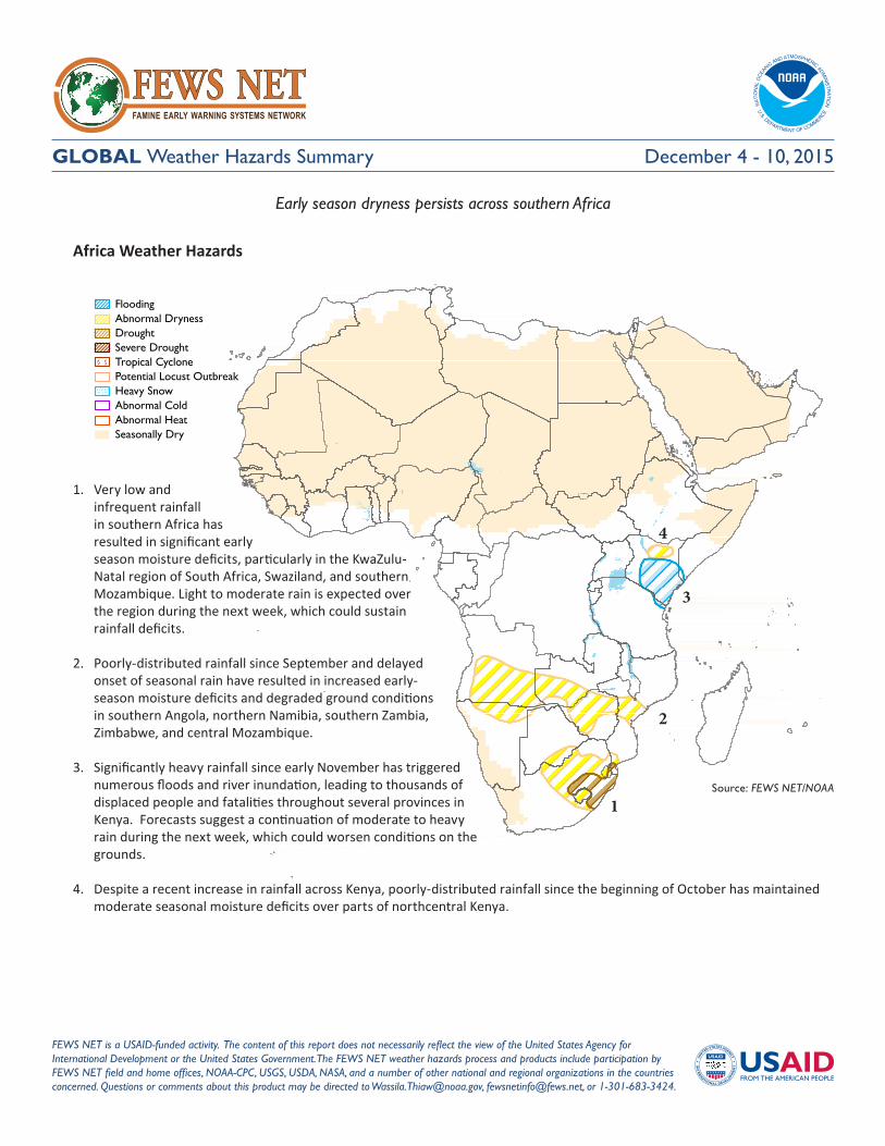
FAMINE EARLY WARNING SYSTEMS NETWORK
FEWS NETGLOBAL Weather Hazards Summary
FEWS NET is a USAID-funded activity. The content of this report does not necessarily reflect the view of the United States Agency for International Development or the United States Government. The FEWS NET weather hazards process and products include participation by FEWS NET field and home offices, NOAA-CPC, USGS, USDA, NASA, and a number of other national and regional organizations in the countries concerned. Questions or comments about this product may be directed to [email protected], [email protected], or 1-301-683-3424.
Early season dryness persists across southern Africa
1
1. Very low and infrequent rainfall in southern Africa has resulted in significant early season moisture deficits, particularly in the KwaZulu-Natal region of South Africa, Swaziland, and southern Mozambique. Light to moderate rain is expected over the region during the next week, which could sustain rainfall deficits.
2. Poorly-distributed rainfall since September and delayed onset of seasonal rain have resulted in increased early-season moisture deficits and degraded ground conditions in southern Angola, northern Namibia, southern Zambia, Zimbabwe, and central Mozambique.
3. Significantly heavy rainfall since early November has triggered numerous floods and river inundation, leading to thousands of displaced people and fatalities throughout several provinces in Kenya. Forecasts suggest a continuation of moderate to heavy rain during the next week, which could worsen conditions on the grounds.
4. Despite a recent increase in rainfall across Kenya, poorly-distributed rainfall since the beginning of October has maintained moderate seasonal moisture deficits over parts of northcentral Kenya.
2
3
4
Africa Weather Hazards
Famine Early Warning Systems Network 2
Weather Hazards Summary
Africa Overview
Dryness prevails throughout Southern Africa
In November, many regions of Southern Africa received below-average rainfall. These included Angola, northeastern Namibia, Botswana, South Africa, Zambia, Zimbabwe, central Mozambique, and western Madagascar. The lack of rain has increased moisture deficits associated with a delayed onset of seasonal rainfall and has worsened dryness across the sub-region. The largest thirty-day rainfall deficits (50-200 mm) were observed throughout south-central Angola, the KwaZulu-Natal region of eastern South Africa, and western Madagascar (Figure 1). The deficient rain since the beginning of October has already negatively impacted cropping and pastoral activities over many local areas. Reports have also indicated livestock deaths associated with the current severely-reduced water availability and a poor rainfall performance during the past season in many countries. If poor rains continue over the upcoming few weeks, seasonal moisture deficits will increase further, delay planting, and adversely affect agricultural activities over wide areas. During the past week, while the northern portions of southern Africa, including northern Angola and northern Zambia, received abundant and above-average rain, much of the southern counterparts recorded limited and light rain. Little to light rain was observed over the abnormally dry areas of northern Namibia, eastern Zambia, South Africa, and southern Mozambique (Figure 2).
During the next week, heavy rain is forecast over Angola, southern DRC, and northern Zambia, which should help to partially erode rainfall deficits over the region. Moderate to locally heavy rain is expected across northern South Africa and central Madagascar. However, suppressed rain is forecast across eastern Zimbabwe, southern Mozambique, and southwestern Madagascar, which will likely worsen dryness over the eastern portions of southern Africa.
Wetness continues over the Greater Horn of Africa
During late November, widespread, enhanced rain continued over most parts of the Greater Horn of Africa. The heaviest rain fell across the Lake Victoria region, with rainfall amounts in excess of 75 mm (Figure 3). Moderate to locally heavy rain was also observed over east-central Kenya, western and east-central Tanzania. In Kenya, the continued ample amounts of rain have exacerbated conditions over local areas after many flooding events during the previous weeks. Light to moderate rain was received in southern Somalia, while little to no rainfall was observed over northwestern Kenya. Since November, Eastern Africa has experienced wetter-than-average conditions, with thirty-day moisture surpluses ranging between 50-200 mm. These included southern Ethiopia, eastern Uganda, Kenya, and central Tanzania.
For the next week, rainfall forecasts suggest continued moderate to heavy rain over southern and coastal Kenya. This maintains elevated risks for flooding over many already-saturated grounds of the country. Moderate to heavy rain is expected over Uganda and western Tanzania.
Figure 2: Satellite-Estimated Rainfall (mm) Valid: November 25 - December 1, 2015
Figure 3: Satellite-Estimated Rainfall (mm) Valid: November 25 - December 1, 2015
Source: NOAA/CPC
Source: NOAA/CPC
Note: The hazards outlook map on page 1 is based on current weather/climate information and short and medium range weather forecasts (up to 1 week). It assesses their potential impact on crop and pasture conditions. Shaded polygons are added in areas where anomalous conditions have been observed. The boundaries of these polygons are only approximate at this continental scale. This product does not reflect long range seasonal climate forecasts or indicate current or projected food security conditions. Questions or comments about this product may be directed to [email protected] or 1-301-683-3424.
Dryness prevails throughout Southern Africa.
During November, many regions of Southern Africa received below-average rainfall. These included Angola, northeastern Namibia, Botswana, South Africa, Zambia, Zimbabwe, central Mozambique, and western Madagascar. The lack of rain has strengthened moisture deficits associated with a delayed onset of seasonal rainfall and has worsened dryness across the sub-region. The largest (50-200 mm) thirty-day rainfall deficits were observed throughout south-central Angola, the KwaZulu-Natal region of eastern South Africa, and western Madagascar (Figure 1). The deficient rain since the beginning of October has already negatively impacted cropping and pastoral activities over many local areas. Reports have also indicated livestock deaths associated with the current severely-reduced water availability and a poor rainfall performance during the past season in many countries. If poor rains continue over the upcoming few weeks, seasonal moisture deficits will increase further, delay planting, and adversely affect agricultural activities over wide areas. During the past week, while the northern portions of Southern Africa, including northern Angola and northern Zambia received abundant and above-average rain, much of the southern counterparts recorded limited and reduced, light rain. Little to light rain was observed over the drier than average areas of northern Namibia, eastern Zambia, South Africa, and southern Mozambique (Figure 2).
During the next week, heavy rain is forecast over Angola, southern DRC, and northern Zambia, which should help to erode rainfall deficits partially over the region. Moderate to locally heavy rain is expected across northern South Africa and central Madagascar. However, suppressed rain is forecast across eastern Zimbabwe, southern Mozambique, and southwestern Madagascar, which will likely worsen dryness over the eastern portions of Southern Africa.
Wetness continues over the Greater Horn of Africa.
During late November, widespread, enhanced rain continued over most parts of the Greater Horn of Africa. The heaviest rain fell across the Lake Victoria region, with rainfall amounts in excess of 75 mm (Figure 3). Moderate to locally heavy rain was also observed over east-central Kenya, western and east-central Tanzania. In Kenya, the continued ample amounts of rain have exacerbated conditions over local areas after many flooding events during the previous weeks. Light to moderate rain was received in southern Somalia, while little to no rainfall was observed over northwestern Kenya. Since November, Eastern Africa has experienced wetter than average conditions, with thirty-day moisture surpluses ranging between 50-200 mm. These included southern Ethiopia, eastern Uganda, Kenya, and central Tanzania. For next week, rainfall forecasts suggest continued moderate to heavy rain over southern and coastal Kenya. This, therefore, maintains elevated risks for flooding over many already-saturated grounds of the country. Moderate to heavy rain is expected over Uganda and western Tanzania.
Satellite-Estimated Rainfall Anomaly (mm) Valid: November 01 – November 30, 2015
Figure 1: NOAA/CPC
Satellite-Estimated Rainfall (mm) Valid: November 25 – December 01, 2015
Figure 2: NOAA/CPC
Satellite-Estimated Rainfall (mm) Valid: November 25 – December 01, 2015
Figure 3: NOAA/CPC
Note: The hazards outlook map on page 1 is based on current weather/climate information and short and medium range weather forecasts (up to 1 week). It assesses their potential impact on crop and pasture conditions. Shaded polygons are added in areas where anomalous conditions have been observed. The boundaries of these polygons are only approximate at this continental scale. This product does not reflect long range seasonal climate forecasts or indicate current or projected food security conditions. Questions or comments about this product may be directed to [email protected] or 1-301-683-3424.
Dryness prevails throughout Southern Africa.
During November, many regions of Southern Africa received below-average rainfall. These included Angola, northeastern Namibia, Botswana, South Africa, Zambia, Zimbabwe, central Mozambique, and western Madagascar. The lack of rain has strengthened moisture deficits associated with a delayed onset of seasonal rainfall and has worsened dryness across the sub-region. The largest (50-200 mm) thirty-day rainfall deficits were observed throughout south-central Angola, the KwaZulu-Natal region of eastern South Africa, and western Madagascar (Figure 1). The deficient rain since the beginning of October has already negatively impacted cropping and pastoral activities over many local areas. Reports have also indicated livestock deaths associated with the current severely-reduced water availability and a poor rainfall performance during the past season in many countries. If poor rains continue over the upcoming few weeks, seasonal moisture deficits will increase further, delay planting, and adversely affect agricultural activities over wide areas. During the past week, while the northern portions of Southern Africa, including northern Angola and northern Zambia received abundant and above-average rain, much of the southern counterparts recorded limited and reduced, light rain. Little to light rain was observed over the drier than average areas of northern Namibia, eastern Zambia, South Africa, and southern Mozambique (Figure 2).
During the next week, heavy rain is forecast over Angola, southern DRC, and northern Zambia, which should help to erode rainfall deficits partially over the region. Moderate to locally heavy rain is expected across northern South Africa and central Madagascar. However, suppressed rain is forecast across eastern Zimbabwe, southern Mozambique, and southwestern Madagascar, which will likely worsen dryness over the eastern portions of Southern Africa.
Wetness continues over the Greater Horn of Africa.
During late November, widespread, enhanced rain continued over most parts of the Greater Horn of Africa. The heaviest rain fell across the Lake Victoria region, with rainfall amounts in excess of 75 mm (Figure 3). Moderate to locally heavy rain was also observed over east-central Kenya, western and east-central Tanzania. In Kenya, the continued ample amounts of rain have exacerbated conditions over local areas after many flooding events during the previous weeks. Light to moderate rain was received in southern Somalia, while little to no rainfall was observed over northwestern Kenya. Since November, Eastern Africa has experienced wetter than average conditions, with thirty-day moisture surpluses ranging between 50-200 mm. These included southern Ethiopia, eastern Uganda, Kenya, and central Tanzania. For next week, rainfall forecasts suggest continued moderate to heavy rain over southern and coastal Kenya. This, therefore, maintains elevated risks for flooding over many already-saturated grounds of the country. Moderate to heavy rain is expected over Uganda and western Tanzania.
Satellite-Estimated Rainfall Anomaly (mm) Valid: November 01 – November 30, 2015
Figure 1: NOAA/CPC
Satellite-Estimated Rainfall (mm) Valid: November 25 – December 01, 2015
Figure 2: NOAA/CPC
Satellite-Estimated Rainfall (mm) Valid: November 25 – December 01, 2015
Temperatures: Following an unseasonably cold week, temperatures averaged at or above normal with the largest positive anomalies (more than 5 °C) across northern Kazakhstan. During the next week, temperatures are likely to average much above-normal. Unseasonably warm temperatures are forecast with maximum temperatures exceeding 25 °C across southern Afghanistan, Turkmenistan, and Uzbekistan.
Precipitation:During the past week, light to moderate precipitation (33 mm or less, liquid equivalent) was observed across northern Kazakhstan, southern Turkmenistan, and Afghanistan. Above-normal precipitation has prevailed throughout much of the region during the past 30 days. Since the beginning of October, snow water volume has been above average across the basins of northeastern Afghanistan and western Tajikistan, according to model analyses. Light to moderate precipitation (locally more than 25 mm) is forecast across Kazakhstan along with northern parts of Turkmenistan and Uzbekistan.
1. Poor rainfall distribution over the past several weeks has maintained abnormal dryness along the southern coast of Haiti, south-central Dominican Republic, northwestern Haiti, and north-central Dominican Republic. Recent increases in rains have eliminated deficits in eastern Dominican Republic, where substantial surpluses are now observed.
1
Central Asia Weather Hazards
Central America and the Caribbean Weather Hazards
Famine Early Warning Systems Network 4
Weather Hazards Summary
ABOUT WEATHER HAZARDSHazard maps are based on current weather/climate information, short and medium range weather forecasts (up to 1 week) and their potential impact on crop and pasture conditions. Shaded polygons are added in areas where anomalous conditions have been observed. The boundaries of these polygons are only approximate at this continental scale. This product does not reflect long range seasonal climate forecasts or indicate current or projected food security conditions.
Central America and the Caribbean Overview
Enhanced rains expected over parts of Guatemala, Belize and northern Honduras during the next week
Compared to the rainfall distribution during mid to late November, a sharp reduction of late season precipitation was observed throughout Central America. According to satellite information, rainfall was light to locally moderate across northern and southern Guatemala, with little to rains received throughout El Salvador, Honduras and Nicaragua. In the last 30 days, November rainfall was well above average, with large moisture surpluses throughout Guatemala, El Salvador, southern Honduras and the Gulf of Fonseca region. However, low to moderate moisture deficits remain over many departments in northern coastal Honduras. Satellite-derived vegetation health indices suggest that ground conditions in Honduras and Nicaragua may not be negatively affected, as the frequency (i.e. number of rain days) of seasonal rainfall has ranged from normal to above-normal.
For the upcoming outlook period, a generally seasonable distribution of rainfall is forecast with the possibility of enhanced rainfall over the Gulf of Honduras region. Heavy rainfall accumulations are possible in northern Guatemala, and along the Atlantic coastlines of Belize and Honduras. Lesser, and potentially below-average rainfall amounts are expected for many interior departments in Nicaragua and Honduras.
Increased rains in late November help relieve dryness in Hispaniola
A southward-extending mid-latitude frontal passage resulted in a considerable increase in late season precipitation during the past week. According to satellite data, the highest weekly precipitation accumulations (>75mm) were across the southern Haitian peninsula, with lesser amounts (>25mm) across several interior departments and some coastal areas. While this recent increase in precipitation during late November is expected to help provide some relief for many anomalously dry areas in Hispaniola, the persistence of infrequent and suppressed rainfall since September has already led to degraded ground conditions, following a poor seasonal rainfall performance from earlier this year. Recent vegetation indices have indicated unfavorable conditions over many local areas along the northern and southern coasts of Hispaniola. Similar conditions exist in Ouest Department of Haiti and neighboring Indepedencia Province in the Dominican Republic. Neutral conditions have been observed across the rest of the island. During the upcoming week, there is a moderate potential for above-average precipitation to continue over southeastern Hispaniola, with more moderate rainfall amounts expected for both interior departments of Haiti and the Dominican Republic. Slightly below average rains are forecast for northern Haiti.
December 4 - 10, 2015
Figure 4: Seven-Day Total Rainfall Forecast (mm)Valid: December 1 - 8, 2015
Questions or comments about this product may be directed to [email protected] or 1-301-683-3424.
Decreased rains received across much of Central America during the last week. Compared to the rainfall distribution during mid/late November, a sharp reduction of late season precipitation was observed throughout Central America. According to satellite information, light to locally moderate amounts of rainfall were felt across northern and southern Guatemala, with little to rains received throughout El Salvador, Honduras and Nicaragua. In the last 30 days, November rainfall was well above average throughout Guatemala, with large moisture surpluses prevalent throughout Guatemala, El Salvador, southern Honduras and the Gulf of Fonseca region. However, low to moderate moisture deficits remain over many departments in northern coastal Honduras. Satellite derived vegetation health indices suggest that ground conditions in Honduras and Nicaragua may not be negatively affected, as the frequency (i.e. number of rain days) of seasonal rainfall has ranged from normal to above-normal. For the upcoming outlook period, a generally seasonable distribution of rainfall is forecast, with the possibility of enhanced rainfall over the Gulf of Honduras region. Heavy rainfall accumulations are possible in northern Guatemala, and along the Atlantic coastlines of Belize and Honduras. Lesser, and potentially below-average rainfall amounts are expected for many interior departments in Nicaragua and Honduras.
Week 1 Rainfall Total and Anomaly Forecast (mm) December 1 – December 8, 2015
Figure 1: Source NOAA / CPC
Questions or comments about this product may be directed to [email protected] or 1-301-683-3424.
Decreased rains received across much of Central America during the last week. Compared to the rainfall distribution during mid/late November, a sharp reduction of late season precipitation was observed throughout Central America. According to satellite information, light to locally moderate amounts of rainfall were felt across northern and southern Guatemala, with little to rains received throughout El Salvador, Honduras and Nicaragua. In the last 30 days, November rainfall was well above average throughout Guatemala, with large moisture surpluses prevalent throughout Guatemala, El Salvador, southern Honduras and the Gulf of Fonseca region. However, low to moderate moisture deficits remain over many departments in northern coastal Honduras. Satellite derived vegetation health indices suggest that ground conditions in Honduras and Nicaragua may not be negatively affected, as the frequency (i.e. number of rain days) of seasonal rainfall has ranged from normal to above-normal. For the upcoming outlook period, a generally seasonable distribution of rainfall is forecast, with the possibility of enhanced rainfall over the Gulf of Honduras region. Heavy rainfall accumulations are possible in northern Guatemala, and along the Atlantic coastlines of Belize and Honduras. Lesser, and potentially below-average rainfall amounts are expected for many interior departments in Nicaragua and Honduras.
Week 1 Rainfall Total and Anomaly Forecast (mm) December 1 – December 8, 2015