FIELD OBSERVATION REPORT in support of APPROVED JURISDICTIONAL DETERMINATION for Stone Ridge Cedar Street Milford, MA U.S. Army Corps of Engineers Regulatory File No. NAE-2007–03200: The Gutierrez Company 1 Wall Street Burlington, MA 01803 February 14, 2011 Alan R. Anacheka-Nasemann, PWS Sr. Project Manager/Ecologist, Regulatory Division U.S. Army Corps of Engineers New England District 696 Virginia Rd. Concord, MA 01742-2751
Transcript
FIELD OBSERVATION REPORT
in support of
APPROVED JURISDICTIONAL DETERMINATION
for
Stone Ridge Cedar Street Milford, MA
U.S. Army Corps of Engineers Regulatory File No. NAE-2007–03200: The Gutierrez Company
1 Wall Street Burlington, MA 01803
February 14, 2011
Alan R. Anacheka-Nasemann, PWS Sr. Project Manager/Ecologist, Regulatory Division
U.S. Army Corps of Engineers New England District
696 Virginia Rd. Concord, MA 01742-2751
i.
TABLE OF CONTENTS Abstract/Summary i 1 Purpose/Introduction 1 2 Site Location 1 3 Materials & Methods 1 4 Background Information 2 5 Applicant Data 4 6 Site Visit Details/Observations 5 7 Findings and Conclusions 6 8 References 7 Figures 9 Abstract: An approved jurisdictional determination under the Clean Water Act was requested by the Gutierrez Company for a ±80-acre site located at the northeast intersection of I-495 and MA-85 (Cedar Street), Milford, Massachusetts. The author, on behalf of the U.S. Army Corps of Engineers, New England District, Regulatory Division, completed a review of existing geographic data followed by site visits. 10 individual water bodies within the parcel boundaries, including 2 streams, and 8 wetlands, totaling approximately 719,000 square feet (16.51 acres) were evaluated for Clean Water Act jurisdiction. Deer Brook, the Charles River and Wetlands 2, 3, 4, 6, 7 and 8 totaling 16.02 acres were determined to be a federally jurisdictional water(s) of the United States. However, wetlands 5 and 9, totaling 0.49 acre, were determined to be a non-jurisdictional, isolated, intrastate wetlands with no nexus to interstate commerce.
1. Purpose: The U.S. Army Corps of Engineers received a request for an approved jurisdictional determination for a ±80-acre parcel of land located at the intersection of Cedar Street (MA-85) and I-495 in the Town of Milford, Worcester County, Massachusetts. The site is the subject of a proposed 625,000 square-foot commercial office space development. 2. Site Location: The parcel is located on Cedar Street in Milford. Table 1 provides coordinates roughly at the center of the site, and watershed information. Figure 1 is the Existing Conditions Site Plan. The site is located along the Charles River and Deer Brook, within the USGS-defined Charles River Watershed (USGS HUC-8 Code: 01090001). The confluence of the two streams is dammed to form Wildcat Pond. The plan view includes 9 individual wetlands (“1-9”; VHB, Inc., 2008), most of which are adjacent to tributaries (Table 2). Wetland 1 is actually off the site; it is included here for general discussion but is not a subject of this determination. Wetlands 7 and 8 converge outside the property boundary, and for purposes of this report are treated as a single water body (“Wetland 7/8”). Table 1: Stone Ridge Tributaries Waterway Latitude/Longitude
(downstream end of reach) Length
(linear feet, on-site)
Flow Regime
Charles River 42.1685; -71.5112 1250 Perennial/RPW Deer Brook 42.1729; -71.5114 1450 Perennial/RPW* *Relatively Permanent Water
Table 2: Attributes of Stone Ridge Wetlands Wetland ID Latitude/Longitude Area (ft2) Area (Acres)
Totals ------------- 719,000 16.51 3. Materials and Methods Background information consisted of known and available maps of the site, most
- 2 -
of which were obtained from existing software or internet sources. The current USGS Quadrangle map was obtained through Terrain Navigator Pro software (Maptech, 2008). Historic USGS Quads dating back to 1895 were downloaded from the University of New Hampshire (2005) on-line library. The soil survey sheet (USDA-NRCS, 1998) was scanned as a *.jpg file. National Wetland Inventory maps (USFWS, 2009) were downloaded for use with GoogleEarth (Google, 2010). The plan view map (VHB, 2010) was converted to an image file and overlaid on the GoogleEarth 2008 aerial photograph. Massachusetts Department of Environmental Protection (MADEP) wetland maps were obtained from MassGIS (2006). An additional aerial photograph was obtained from Bing Maps (Microsoft Corp., 2009). An additional web search yielded a map of the proposed Upper Charles River Trail (Beals & Thomas, Inc., 2008). Field reconnaissance was conducted on April 8, 2009, January 28, 2010, April 2, 2010 and April 15, 2010. On January 28, 2010 a Trimble GeoXT GeoExplorer Series 2005 Model 5.1.16 GPS unit was used to identify specific points along the site route, including Wetland 9, Deer Brook and an unnamed tributary, in order to ascertain distance between each of wetlands 5, 6 and 9, and these streams. On April 2, 2010, a Garmin eTrex® Vista™ GPS unit was used to mark the route of the ephemeral outlet from Wetland 6 into Deer Brook (hereinafter “Wetland 6 Outlet”). Site data were entered into a field book and climatic conditions recorded. 4. Background Information: a. USGS Milford 7.5’ X 15’ Quadrangle, 1982: The most current USGS Quadrangle (Figure 2) shows the site as completely wooded, with moderately steep topography sloping NW-SE. The eastern boundary of the parcel is an old N-S oriented railroad grade, and the Charles River flows north to south just below Wildcat Pond as it crosses the site. Deer Brook (unlabeled on this map) enters Wildcat Pond from the northwest, and forms the easterly boundary of the site. I-495 forms the westerly boundary. Wildcat Pond is an impoundment of the Charles River, which drains to the south and off the site; it eventually takes a northerly route through Boston and drains into Boston Harbor, a tidal, navigable water of the United States. Marsh symbols are absent, and no additional aquatic resources are identified on the 1982 map. Comparison of the USGS Quad with the VHB delineation map suggests that Wetlands 1 and 3 directly abuts the Charles River; Wetland 2 directly abuts an unnamed tributary to Deer Brook, and Wetland 4 directly abuts Deer Brook itself. Wetlands 5, 6 and 9 do not appear to abut any existing stream. Wetland 7/8 drains northwest via an unnamed tributary to Huckleberry Brook, which discharges into Milford Pond, an additional impoundment of the Charles River located approximately 4600 feet downstream of Wildcat Pond. b. USGS Milford, MA Quadrangle (7.5’), 1943: The 1943 Quadrangle (Figure 3) shows a marsh symbol in the north-central part of the site; this location corresponds to Wetland 6 from the VHB map. The position of the Wildcat Pond dam is also shown. The map suggests that the existing railroad grade was active at that time. I-495 did not exist.
- 3 -
c. USGS Blackstone, MA Quadrangle (15’), 1895: The 1895 Quadrangle (Figure 3) shows the confluence of Deer Brook and the Charles River, but no pond or dam is indicated. This suggests that Wildcat Pond had not been created as of 1895. No other aquatic resources are indicated. d. NRCS (1998) Soil Survey: Worcester County, MA, Southeastern Part (Sheet 14): Table 3 identifies the soils indicated on the site. Whitman soils are listed on the NRCS (2010) hydric soils list and mostly occur in the area of Wetland 6 and also in narrow bands at Wetlands 1- 4 and 7/8. Marsh symbols identified within the Canton series and adjacent to I-495 correspond to Wetland 5. Wetland 9 is not demarcated by any feature of the soils map, which is otherwise in general agreement with the VHB wetland delineation for this site. Table 2: Soils found on the Stone Ridge property:
Symbol Series Name Tex-ture
Slope% or Suborder, Group, Subgroup
Drainage Class
Hydric Inclu- sions?
73 Whitman, x-stony sl 0-3% P Y N 102C/D Chatfield-Hollis Rock
Outcrop complex 3-15%/15-35% E N N
253D Hinckley sl 15-35% E N N 422C/D Canton, x-stony fsl 3-15%/15-35% VP Y N
Key: f = fine; s = sand/sandy, si = silt/silty; l = loam/loamy; c = clay e. National Wetland Inventory (NWI), Milford MA Quad, 2005: Figure 6 is an overlay of the existing site plan and the digital NWI map on the existing GoogleEarth (2010) image of the 2005 MassGIS aerial photograph. Wildcat Pond is classed as PUBHh (palustrine, unconsolidated bottom, permanent, diked/impounded). Wetlands 2 - 5 are classed as PFO1E (palustrine, forested, broad-leaved deciduous, seasonal saturated). Wetland 6 is classified as PFO1B (Palustrine, forested, broad-leaved deciduous, saturated). The NWI wetland indicators are all within the Whitman soil types except for Wetland 5, located adjacent to I-495. Wetlands 1, 7/8 and 9 do not appear on the NWI map. f. State/Local Wetland Inventory Maps: MassGIS DEP Wetlands Image, 2005: The MassGIS MADEP wetlands “general categories” map is overlain on the USGS Quadrangle as 2008 aerial photograph as Figure 7. Wetlands 1, 2, 4-6 and 7/8 are classed “wooded marsh”. Figure 8 shows the DEP detailed wetlands map overlain on the 2008 aerial photograph of the site. All of the above wetlands are identified as “wooded swamp-deciduous” and Wildcat Pond is classed as “open water.” Both figures also identify “wetland connections,” suggestive of small tributaries linking many of the wetlands to the Charles River; one of these is associated with Wetland 3. The MADEP wetland maps contain wetlands that are either not found on the NWI map or are more extensive than the latter suggests. Wetland 9 is not identified on the MADEP maps.
- 4 -
g. Aerial Photographs: Bing USGS Color Infrared Aerials, 2010: The best available aerial photograph shows dark areas that clearly demarcate Deer Brook, the Charles River, Wildcat Pond, and several of the wetlands, which appear more extensive than identified by the NWI and DEP wetland polygons (Figure 9). h. Other Resources: Upper Charles River Trail Map – Milford Section (Beals & Thomas, 2008): This map illustrates that the abandoned railroad grade is designated to become a bicycle trail that would traverse the east boundary of the site. It shows the recreational uses of the Charles River Watershed in a larger context than that of the site itself. i. Other Resources: Report on the Navigable Status of the Charles River (CENAE-R, Unpublished M.S.S., ca. 1975): Past navigability studies for the Charles River suggested that there was reason to believe that waterborne commerce occurred below the dam in West Medway, Massachusetts, approximately 8 miles downstream of the Stone Ridge site. Pursuant to the U.S. Supreme Court decision in Rapanos v. United States (2006), the Charles River can be considered a traditional navigable water (TNW) pursuant to the Clean Water Act, from that point downstream. 5. Applicant Data
The original permit application was submitted by VHB (2008) on September 17, 2008. It included a general description of the wetland resources identified on the site, along with an existing conditions plan map. Wetland delineation data sheets were provided for Wetland 9 only, as it is the only wetland that would be impacted by the proposed office park; these data sheets were prepared by VHB on August 21, 2008, solely for U.S. Army Corps of Engineers regulatory purposes. The wetlands had actually been delineated previously, and the Town of Milford had issued an Order of Resource Area Delineation (ORAD) on April 20, 2007. The ORAD affirms the accuracy of the Massachusetts jurisdictional aquatic resource boundaries. Wetlands 1-4 and 7/8 are regulated as “bordering vegetated wetlands (BVW),” and wetlands 5 and 6 are regulated as “isolated land subject to flooding (ILSF).” Wetland 9 is not regulated under the Massachusetts Wetland Protection Act (WPA). Wetlands 1, 2, 4, 5, 6, and 7/8 correspond to wetlands that appear on the MADEP wetland maps (Figures 7 and 8); in general, all are far more extensive than indicated by the latter. Wetland 4 directly abuts Deer Brook along the easterly boundary of the site and incorporates two wetlands that appear as separate and discontinuous wetlands on the NWI/DEP wetland maps. Wetland 3 is associated with a MADEP “wetland connection” on the DEP maps. Wetland 1 is located off the property, opposite the old railroad grade. Among the data provided in the VHB report is the Massachusetts Natural Heritage and Endangered Species Program (NHESP) map indicating that the site occurs with habitat for wood turtle (Clemmys insculpta), a state listed Species of Special Concern.
- 5 -
6. Site Visit Details/Observations
Table 4 provides details of the first of four site visits for this proposed project. The primary purpose of this site visit was to examine cultural and archaeological resources to determine whether portions of the site are eligible for listing on the National List of Historic Places pursuant to §106 of the National Historic Preservation Act. However, brief reconnaissance of some of the wetland areas was conducted. In particular, we examined Wetlands 5, 6 and 9 for potential jurisdiction. Of these, wetlands 5 and 6 both contained standing water that would be indicative of vernal pool habitat. However, hydrology in wetland 9 was limited to a 3’-diameter puddle. Considering the fact that it was April, it was clear that wetland 9 would be expected to be Table 4: Stone Ridge Site Visit Parameters: Date of Inspection 8 April 2009; 0900-1230 Weather Pt Cloudy, 35oF; light snow flurries by end. Participants Alan Anacheka-Nasemann, Rick Kristoff & Kate Atwood,
CENAE-R; Ed Reiner, US EPA; Carol Weed and Matt Varrell, VHB; Chris Novack, Ed Scioli, and Bill Caulder, The Gutierrez Company; Bettina Washington, Jonathan Perry & Elizabeth James-Perry, Wampanoag Tribe of Aquinnah
relatively ephemeral, and thus unable to support viable populations of aquatic invertebrates and/or amphibians. Although it had been more than two years since the wetlands had been flagged, some flags were still and place and identifiable; these were appropriately placed, and although data sheets were severely wanting in the delineation report, we have no reason to doubt the positions of any delineation flags hung by VHB personnel. Table 5: Stone Ridge Site Visit No. 2 Parameters: Date of Inspection 28 Jan 2010; 1230-1530 Weather Clear, 35oF; Wind WNW, 10 mph Participants Alan Anacheka-Nasemann, Rick Kristoff & Angela Repella,
CENAE-R The main purpose of the second site visit was to trace the route of previously unmapped intermittent streams to determine their proximity to wetlands 5, 6 and 9. We followed the edge of Wetland 4, parallel to Deer Brook, making our way to a small tributary that enters the brook from the east. This we followed upstream, using the GPS unit to input data points. From there we made our way to Wetland 9, which was not at all saturated.
- 6 -
Table 6: Stone Ridge Site Visit No. 3 Parameters Date of Inspection 2 April 2010; 1230-1530 Weather Clear, 75oF; Wind SE, calm to 5 mph Participants Alan Anacheka-Nasemann, CENAE-R The third site visit occurred shortly after some of the heaviest rains on record in central Massachusetts. The purpose was to examine drainage patterns on the site and also to determine whether aquatic invertebrates and/or amphibians could be identified in wetlands 5 and 6. On this occasion I discovered that Wetland 6 was overflowing into a tiny ephemeral streamlet that trickled down the hillside (as existing contours would predict) on into Deer Brook. I found numerous mosquito larvae (DIPTERA: CULIDAE), approximately 6 adult water striders (HEMIPTERA: GERRIDAE), several isopods (MALACOSTRACA: ISOPODA), and a larval predacious diving beetle (COLEOPTERA: DYTISCIDAE) within Wetland 6. Table 7: Stone Ridge Site Visit No. 4 Parameters Date of Inspection 15 April 2010; 1230-1530 Weather Clear, 75oF; Wind SE, calm to 5 mph Participants Alan Anacheka-Nasemann, Daniel Vasconcelos & Angela
Repella, CENAE-R The purpose of the fourth site visit was to determine whether there were species of aquatic fauna present in wetlands 5 or 6 that might indicate ecological relationships between the wetlands and the nearby tributaries. Upon entering the site, en route to Wetland 6, we found numerous American toad (Bufo americanus) egg masses in Wetland 2. We found 3 wood frog (Rana sylvatica) egg masses in Wetland 6. The only invertebrates observed were mosquito larvae and pupae. We also found 2 spotted salamander (Ambystoma maculatum) egg masses in Wetland 5. 7. Findings and Conclusions
Deer Brook and the Charles River are relatively permanent, perennial waterways that are part of a surface tributary system to navigable waters of the United States, and are therefore waters of the United States pursuant to 33 CFR 328.3(a)(5). Wildcat Pond is an impoundment of both of these waters and is thus a water of the United States under 33 CFR 328.3(a)(4). Wetlands 1-4 and 7/8 are adjacent (contiguous) to and directly abutting relatively permanent waters (Deer Brook, the Charles River and the tributary that drains Wetland 2) and are waters of the U.S. pursuant to 33 CFR 328.3(a)(7). Wetland 6 directly abuts a non-RPW, an ephemeral, unnamed tributary to Deer Brook that appears to flow only after significant rainfall events. As such, Wetland 6 demonstrably contributes to flood attenuation by retaining stormwater, preventing rapid runoff into Deer Brook. Wetland 6 also contains amphibian and aquatic invertebrate species that are indicative of vernal pools.
- 7 -
Wetland 5 may have been created as a consequence of the construction of I-495, this particular section of which occurred in the 1960s (Eastern Roads, 2010). The wetland may have resulted through interrupting the normal drainage of the land to the south, thereby pooling water. However, it may have always been a natural wetland notwithstanding the fact that it is not indicated as such on the NRCS soil survey. In any event, today the pond is a natural wetland, with some vernal pool species. It has no identifiable surface water outlet, and is located approximately 750 feet from the unnamed tributary that drains Wetland 2 into Deer Brook, and is over 1000 feet from Deer Brook itself. Little evidence exists to suggest that Wetland 5 plays a role in the ecology of Deer Brook or its unnamed intermittent or ephemeral tributaries. Wetland 9, although reasonably close to Deer Brook, has no outlets, nor does it pond water for a sufficient period of time to allow the growth of appreciable numbers of aquatic fauna – I suspect its hydroperiod is too short even to support mosquito populations. I suspect it only has wetland hydrology due to an impermeable confining layer (most likely bedrock) and even then for extremely short duration events. Wetlands 5 and 9 are not waters of the U.S.; they are isolated, intrastate wetland with no nexus to interstate commerce, pursuant to the U.S. Supreme Court decision in Solid Waste Agency of Northern Cook County v. U.S. Army Corps of Engineers (SWANCC; 2001). Although Wetland 9 is within approximately 325 feet of the unnamed tributary to Deer Brook, and 425 feet of Deer Brook itself, there is no evidence of use of the wetland by faunal species that rely on both flowing water and nearby, seasonal wetlands. As such, Wetland 9 lacks a significant nexus to navigable waters of the United States, and cannot be deemed to be adjacent as defined by 33 CFR 328.3(c). Wetland 5 is at least 1000 linear feet from Deer Brook, and is at least 30m (98 ft.) higher in elevation. An internet search of the Charles River, Deer Brook and Wildcat Pond failed to identify any known records of aquatic-dependent fauna in these waters that would conceivably utilize both said waters and Wetland 5. Accordingly, Wetland 5 cannot be considered ecologically adjacent to a tributary to navigable waters of the U.S. 8. References Beals & Thomas, Inc. 2008. Upper Charles Trail - Milford Section.
<http://www.milford.ma.us/trail/index.htm> (April 12, 2010). Cowardin, L.M., Carter, V., Golet, F.C., and LaRoe, E.T. 1979. Classification of
Wetlands and Deepwater Habitats of the United States. U.S. Fish & Wildlife Svc. Tech. Rep. FWS/)BS-79/31, Washington, 130pp.
DeGraaf, R. M. and Yamasaki, M. 2001. New England Wildlife: Habitat, Natural
History, and Distribution. University Press of New England, Hanover, NH, 482pp. Eastern Roads. 2010. Interstate 495: Outer Circumferential Highway – Historic
Overview. <http://www.bostonroads.com/roads/I-495_MA/> April 9, 2010
- 8 -
Federal Register November 13, 1986, 33 CFR 328.3(a) and (c) Federal Register November 13, 1986, Preamble to 33 CFR 328.3, p. 41217. Federal Register March 9, 2000, Preamble, II. General Comments - Jurisdictional Issues,
pages 12823-4. Google. 2010. Google Earth EC, November 13, 2007, Mountain View, CA. Maptech, Inc., 2008. Terrain Navigator Pro Network Edition, v. 8.5. Maptech, Inc.,
Amesbury, MA. Massachusetts Office of Geographic and Environmental Information (MassGIS). 2005.
OLIVER -- The MassGIS Online Data Viewer, v. 3.1. MassGIS, August 13, 2009, <http://maps.massgis.state.ma.us/massgis_viewer/index.htm> (March 23, 2010).
Massachusetts Office of Geographic and Environmental Information (MassGIS). 2006.
DEP Wetlands, 1:12,000. MassGIS, December 22, 2006, <http://www.mass.gov/mgis/st_wetdep.htm> (March 23, 2010).
Rapanos v. United States and Carabell v. United States (126 S. Ct. 2208, 2006). Solid Waste Agency of Northern Cook County v. U.S. Army Corps of Engineers, 531 U.S.
159 (2001) University of New Hampshire Library. 2001. Historic USGS Maps of New England &
NY. UNH, May 5, 2007, <http://docs.unh.edu/nhtopos/nhtopos.htm> (March 18, 2010).
U.S. Army Corps of Engineers, New England Division. ca. 1975. Report on the
Navigable Status of the Charles River (CENAE-R, unpublished m.s.s.) USDA Natural Resource Conservation Service. 1998. Soil Survey of Worcester County,
Massachusetts, Southern Part. NRCS, Amherst, MA 165p., appendices. --------. 2010. National Hydric Soils List by State. USDA-NRCS, February, 2010,
<http://soils.usda.gov/use/hydric/lists/state.html> (April 1, 2010) U.S. Fish and Wildlife Service. 2009. View Wetlands Data with Google Earth. USFWS,
April 6, 2010, <http://www.fws.gov/wetlands/Data/GoogleEarth.html> (April 12, 2010).
- 9
-
Fig
ure
1:
Exi
stin
g C
ondi
tion
s P
lan
of S
tone
Rid
ge p
rope
rty,
sho
win
g C
harl
es R
iver
, Dee
r B
rook
and
Wet
land
s 1-
9 (V
HB
, Inc
., 20
07).
- 10 -
Figure 2: Location of Stone Ridge Site on USGS Milford, MA 1982 Quadrangle
- 11 -
Figure 3: Location of Stone Ridge site on USGS Milford, MA 1943 7.5’ Quadrangle.
- 12 -
Figure 4: Location of Stone Ridge site on 1895 Blackstone, MA 15’ Quadrangle.
- 13 -
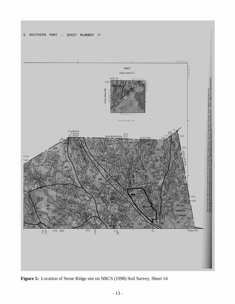
Figure 5: Location of Stone Ridge site on NRCS (1998) Soil Survey, Sheet 14
- 14
-
F
igu
re 6
: O
verl
ay o
f S
tone
Rid
ge E
xist
ing
Con
diti
ons
Pla
n an
d N
WI
poly
gons
on
Goo
gleE
arth
aer
ial i
mag
e, w
ith
appr
oxim
ate
site
wal
k pa
th
from
28
Jan
2010
sit
e w
alk.
Not
e th
at tr
ibut
ary
rout
e is
sam
e as
out
let o
f W
etla
nd 2
and
3.
- 15
-
Fig
ure
7:
Mas
sGIS
DE
P W
etla
nds
(Gen
eral
) –
US
GS
Qua
d O
verl
ay o
f S
tone
Rid
ge s
ite.
MA
DE
P W
etla
nd c
ateg
orie
s an
d N
RC
S s
oil t
ypes
as
abo
ve.
- 16
-
Fig
ure
8:
Mas
sGIS
DE
P W
etla
nds
(Det
aile
d)–2
008
Aer
ial I
mag
e O
verl
ay o
f S
tone
Rid
ge s
ite.
MA
DE
P W
etla
nd c
ateg
orie
s as
abo
ve.
- 17
-
Fig
ure
9:
Mic
roso
ft®
Bin
g TM A
eria
l Pho
to I
mag
e of
Sto
ne R
idge
Sit
e.
- 18 -
Figure 10: Copy of Upper Charles Trail Milford Section Map, showing, route of existing/proposed bike trail that follows old railroad grade along eastern boundary of Stone Ridge site.
- 19
-
Fig
ure
11-
0: E
xist
ing
Con
diti
ons
Pla
n sh
owin
g ph
otog
raph
pos
itio
ns a
nd a
ngle
s fo
r al
l Sto
ne R
idge
pho
tos
by C
orps
per
sonn
el
1,3
2,4
5
6
7 8 9 10
11 12
- 20 -
Figure 11-1: Lower end of intermittent (RPW) tributary (“Wetland 4 Outlet”) that drains Wetland 4 into Wetland 2 and Deer Brook (28 Jan 2010).
Figure 11-2: Additional view of Wetland 4 Outlet, looking upstream (28 Jan 2010).
- 21 -
Figure 11-3: Lower End of Wetland 4 Outlet (approximately same position as Fig. 11-1, 2 months later; 2 Apr 2010).
Figure 11-4: Additional view of Wetland 4 Outlet, looking upstream (approximately same position as Fig. 11-1, 2 months later; 2 Apr 2010).
- 22 -
Figure 11-5: View of Wetland 6. This vernal pool has pit-and-mound topography with shrubs scattered throughout.
Figure 11-6: This ephemeral outlet drains wetland 6 which is located at the very top of the photo. The outlet (“Wetland 6 Outlet”) was visibly flowing at this location.
- 23 -
Figure 11-7: The Wetland 6 outlet occasionally disappears under leaf letter and then re-emerges. Note disturbed/accumulated litter above rocks, and emergence of stream below.
Figure 11-8: Additional view of stream flow. In this location the channel is steeper, more incised and more obvious.
- 24 -
Figure 11-9: At this location, just above the existing cart path, the Wetland 6 Outlet seems to suddenly appear from under this rock.
Figure 11-10: The cart path interrupts what would be the natural “channel” for the Wetland 6 outlet, causing it to flatten into puddles which narrow into distinct outlets at various points, including the large bolder in the upper left corner of the photo.
- 25 -
Figure 11-11: In this photo, leave litter largely obscures stream pathway which follows downed branch from lower right corner. Deer Brook in background.
Figure 11-12: The stream enters Deer Brook at a point just to the right of this tree. Note 2 “piles” of leaf litter circled that have accumulated due to higher flows in recent past.
APPROVED JURISDICTIONAL DETERMINATION FORM
U.S. Army Corps of Engineers
This form should be completed by following the instructions provided in Section IV of the JD Form Instructional Guidebook. SECTION I: BACKGROUND INFORMATION A. REPORT COMPLETION DATE FOR APPROVED JURISDICTIONAL DETERMINATION (JD): 14 Feb 2011 B. DISTRICT OFFICE, FILE NAME, AND NUMBER:New England District, Stone Ridge, NAE-2007-3200-JD#1: Charles River, Wildcat Pond, Wetland 1 and Wetland 3 C. PROJECT LOCATION AND BACKGROUND INFORMATION:
State:MA County/parish/borough: Worcester City: Milford Center coordinates of site (lat/long in degree decimal format): Lat. 42.16541° N, Long. 71.51927° W. Universal Transverse Mercator: 4671214N; 219895E (Zone 19) Name of nearest waterbody: Charles River Name of nearest Traditional Navigable Water (TNW) into which the aquatic resource flows: Charles River Name of watershed or Hydrologic Unit Code (HUC): 01090001 (Charles)
Check if map/diagram of review area and/or potential jurisdictional areas is/are available upon request. Check if other sites (e.g., offsite mitigation sites, disposal sites, etc…) are associated with this action and are recorded on a
different JD form. D. REVIEW PERFORMED FOR SITE EVALUATION (CHECK ALL THAT APPLY):
Office (Desk) Determination. Date: 18 Jun 2010 Field Determination. Date(s): 8 Apr 2009; 28 Jan 2010; 2 Apr 2010; 15 Apr 2010.
SECTION II: SUMMARY OF FINDINGS A. RHA SECTION 10 DETERMINATION OF JURISDICTION. There Are no “navigable waters of the U.S.” within Rivers and Harbors Act (RHA) jurisdiction (as defined by 33 CFR part 329) in the review area. [Required]
Waters subject to the ebb and flow of the tide. Waters are presently used, or have been used in the past, or may be susceptible for use to transport interstate or foreign commerce.
Explain: The Charles River becomes navigable for RHA purposes at the Watertown, MA dam and this site is well above that location.
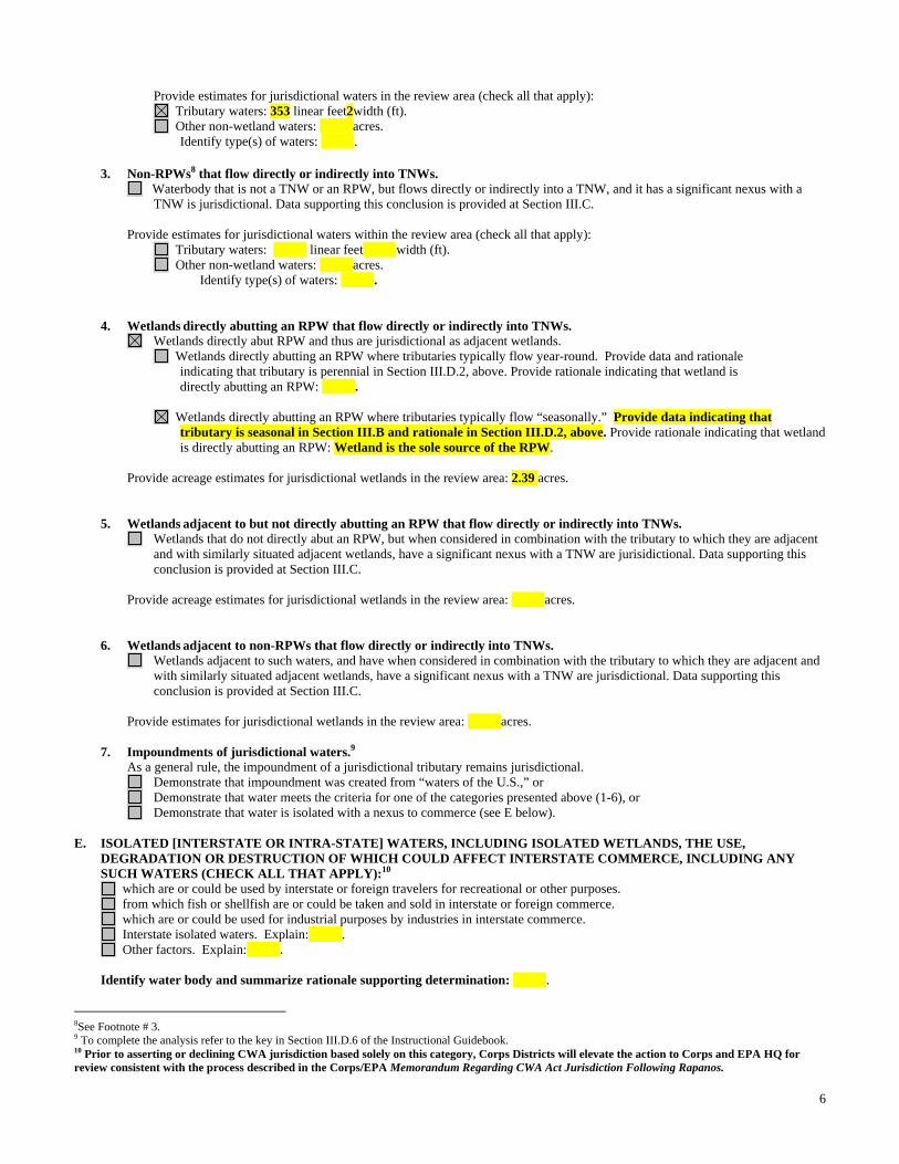
B. CWA SECTION 404 DETERMINATION OF JURISDICTION. There Are “waters of the U.S.” within Clean Water Act (CWA) jurisdiction (as defined by 33 CFR part 328) in the review area. [Required] 1. Waters of the U.S. a. Indicate presence of waters of U.S. in review area (check all that apply): 1 TNWs, including territorial seas Wetlands adjacent to TNWs Relatively permanent waters2 (RPWs) that flow directly or indirectly into TNWs (Charles River) Non-RPWs that flow directly or indirectly into TNWs Wetlands directly abutting RPWs that flow directly or indirectly into TNWs (Wetlands 1 and 3) Wetlands adjacent to but not directly abutting RPWs that flow directly or indirectly into TNWs Wetlands adjacent to non-RPWs that flow directly or indirectly into TNWs Impoundments of jurisdictional waters (Wildcat Pond = Impoundment of Charles River) Isolated (interstate or intrastate) waters, including isolated wetlands
b. Identify (estimate) size of waters of the U.S. in the review area: Non-wetland waters: 1428 linear feet: 10 width (ft) and/or 2.1 acres. Wetlands: 9.74 acres. c. Limits (boundaries) of jurisdiction based on: 1987 Delineation Manual Elevation of established OHWM (if known):285'MSL (est.). 2. Non-regulated waters/wetlands (check if applicable):3 Potentially jurisdictional waters and/or wetlands were assessed within the review area and determined to be not jurisdictional.
Explain: .
1 Boxes checked below shall be supported by completing the appropriate sections in Section III below. 2 For purposes of this form, an RPW is defined as a tributary that is not a TNW and that typically flows year-round or has continuous flow at least “seasonally” (e.g., typically 3 months). 3 Supporting documentation is presented in Section III.F.
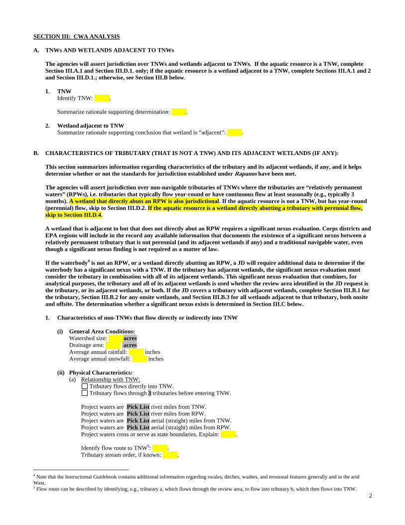
2
SECTION III: CWA ANALYSIS A. TNWs AND WETLANDS ADJACENT TO TNWs The agencies will assert jurisdiction over TNWs and wetlands adjacent to TNWs. If the aquatic resource is a TNW, complete
Section III.A.1 and Section III.D.1. only; if the aquatic resource is a wetland adjacent to a TNW, complete Sections III.A.1 and 2 and Section III.D.1.; otherwise, see Section III.B below.
1. TNW Identify TNW: .
Summarize rationale supporting determination: .
2. Wetland adjacent to TNW Summarize rationale supporting conclusion that wetland is “adjacent”: .
B. CHARACTERISTICS OF TRIBUTARY (THAT IS NOT A TNW) AND ITS ADJACENT WETLANDS (IF ANY): This section summarizes information regarding characteristics of the tributary and its adjacent wetlands, if any, and it helps
determine whether or not the standards for jurisdiction established under Rapanos have been met. The agencies will assert jurisdiction over non-navigable tributaries of TNWs where the tributaries are “relatively permanent
waters” (RPWs), i.e. tributaries that typically flow year-round or have continuous flow at least seasonally (e.g., typically 3 months). A wetland that directly abuts an RPW is also jurisdictional. If the aquatic resource is not a TNW, but has year-round (perennial) flow, skip to Section III.D.2. If the aquatic resource is a wetland directly abutting a tributary with perennial flow, skip to Section III.D.4.
A wetland that is adjacent to but that does not directly abut an RPW requires a significant nexus evaluation. Corps districts and
EPA regions will include in the record any available information that documents the existence of a significant nexus between a relatively permanent tributary that is not perennial (and its adjacent wetlands if any) and a traditional navigable water, even though a significant nexus finding is not required as a matter of law.
If the waterbody4 is not an RPW, or a wetland directly abutting an RPW, a JD will require additional data to determine if the waterbody has a significant nexus with a TNW. If the tributary has adjacent wetlands, the significant nexus evaluation must consider the tributary in combination with all of its adjacent wetlands. This significant nexus evaluation that combines, for analytical purposes, the tributary and all of its adjacent wetlands is used whether the review area identified in the JD request is the tributary, or its adjacent wetlands, or both. If the JD covers a tributary with adjacent wetlands, complete Section III.B.1 for the tributary, Section III.B.2 for any onsite wetlands, and Section III.B.3 for all wetlands adjacent to that tributary, both onsite and offsite. The determination whether a significant nexus exists is determined in Section III.C below.
1. Characteristics of non-TNWs that flow directly or indirectly into TNW
(i) General Area Conditions: Watershed size: Pick List Drainage area: Pick List Average annual rainfall: inches Average annual snowfall: inches (ii) Physical Characteristics: (a) Relationship with TNW: Tributary flows directly into TNW. Tributary flows through Pick List tributaries before entering TNW. Project waters are Pick List river miles from TNW. Project waters are Pick List river miles from RPW. Project waters are Pick List aerial (straight) miles from TNW. Project waters are Pick List aerial (straight) miles from RPW. Project waters cross or serve as state boundaries. Explain: . Identify flow route to TNW5: . Tributary stream order, if known: .
4 Note that the Instructional Guidebook contains additional information regarding swales, ditches, washes, and erosional features generally and in the arid West. 5 Flow route can be described by identifying, e.g., tributary a, which flows through the review area, to flow into tributary b, which then flows into TNW.
3
(b) General Tributary Characteristics (check all that apply): Tributary is: Natural Artificial (man-made). Explain: . Manipulated (man-altered). Explain: .
Tributary properties with respect to top of bank (estimate):
Average width: feet Average depth: feet Average side slopes: Pick List. Primary tributary substrate composition (check all that apply):
Silts Sands Concrete Cobbles Gravel Muck Bedrock Vegetation. Type/% cover: Other. Explain: . Tributary condition/stability [e.g., highly eroding, sloughing banks]. Explain: . Presence of run/riffle/pool complexes. Explain: . Tributary geometry: Pick List Tributary gradient (approximate average slope): % (c) Flow: Tributary provides for: Pick List Estimate average number of flow events in review area/year: Pick List Describe flow regime: . Other information on duration and volume: . Surface flow is: Pick List. Characteristics: . Subsurface flow: Pick List. Explain findings: . Dye (or other) test performed: . Tributary has (check all that apply): Bed and banks OHWM6 (check all indicators that apply):
clear, natural line impressed on the bank the presence of litter and debris changes in the character of soil destruction of terrestrial vegetation shelving the presence of wrack line vegetation matted down, bent, or absent sediment sorting leaf litter disturbed or washed away scour sediment deposition multiple observed or predicted flow events water staining abrupt change in plant community other (list):
Discontinuous OHWM.7 Explain: .
If factors other than the OHWM were used to determine lateral extent of CWA jurisdiction (check all that apply): High Tide Line indicated by: Mean High Water Mark indicated by:
oil or scum line along shore objects survey to available datum; fine shell or debris deposits (foreshore) physical markings; physical markings/characteristics vegetation lines/changes in vegetation types. tidal gauges other (list):
(iii) Chemical Characteristics:
Characterize tributary (e.g., water color is clear, discolored, oily film; water quality; general watershed characteristics, etc.). Explain: .
Identify specific pollutants, if known: .
6A natural or man-made discontinuity in the OHWM does not necessarily sever jurisdiction (e.g., where the stream temporarily flows underground, or where the OHWM has been removed by development or agricultural practices). Where there is a break in the OHWM that is unrelated to the waterbody’s flow regime (e.g., flow over a rock outcrop or through a culvert), the agencies will look for indicators of flow above and below the break. 7Ibid.
4
(iv) Biological Characteristics. Channel supports (check all that apply): Riparian corridor. Characteristics (type, average width): . Wetland fringe. Characteristics: . Habitat for:
Federally Listed species. Explain findings: . Fish/spawn areas. Explain findings: . Other environmentally-sensitive species. Explain findings: . Aquatic/wildlife diversity. Explain findings: . 2. Characteristics of wetlands adjacent to non-TNW that flow directly or indirectly into TNW
(i) Physical Characteristics: (a) General Wetland Characteristics: Properties: Wetland size: acres Wetland type. Explain: . Wetland quality. Explain: . Project wetlands cross or serve as state boundaries. Explain: .
(b) General Flow Relationship with Non-TNW: Flow is: Pick List. Explain: . Surface flow is: Pick List Characteristics: . Subsurface flow: Pick List. Explain findings: . Dye (or other) test performed: . (c) Wetland Adjacency Determination with Non-TNW:
Directly abutting Not directly abutting Discrete wetland hydrologic connection. Explain: . Ecological connection. Explain: . Separated by berm/barrier. Explain: . (d) Proximity (Relationship) to TNW
Project wetlands are Pick List river miles from TNW. Project waters are Pick List aerial (straight) miles from TNW.
Flow is from: Pick List. Estimate approximate location of wetland as within the Pick List floodplain. (ii) Chemical Characteristics:
Characterize wetland system (e.g., water color is clear, brown, oil film on surface; water quality; general watershed characteristics; etc.). Explain: .
Identify specific pollutants, if known: . (iii) Biological Characteristics. Wetland supports (check all that apply): Riparian buffer. Characteristics (type, average width): . Vegetation type/percent cover. Explain: . Habitat for:
3. Characteristics of all wetlands adjacent to the tributary (if any) All wetland(s) being considered in the cumulative analysis: Pick List Approximately ( ) acres in total are being considered in the cumulative analysis.
5
For each wetland, specify the following: Directly abuts? (Y/N) Size (in acres) Directly abuts? (Y/N) Size (in acres)
Summarize overall biological, chemical and physical functions being performed: .
C. SIGNIFICANT NEXUS DETERMINATION
A significant nexus analysis will assess the flow characteristics and functions of the tributary itself and the functions performed by any wetlands adjacent to the tributary to determine if they significantly affect the chemical, physical, and biological integrity of a TNW. For each of the following situations, a significant nexus exists if the tributary, in combination with all of its adjacent wetlands, has more than a speculative or insubstantial effect on the chemical, physical and/or biological integrity of a TNW. Considerations when evaluating significant nexus include, but are not limited to the volume, duration, and frequency of the flow of water in the tributary and its proximity to a TNW, and the functions performed by the tributary and all its adjacent wetlands. It is not appropriate to determine significant nexus based solely on any specific threshold of distance (e.g. between a tributary and its adjacent wetland or between a tributary and the TNW). Similarly, the fact an adjacent wetland lies within or outside of a floodplain is not solely determinative of significant nexus. Draw connections between the features documented and the effects on the TNW, as identified in the Rapanos Guidance and discussed in the Instructional Guidebook. Factors to consider include, for example: Does the tributary, in combination with its adjacent wetlands (if any), have the capacity to carry pollutants or flood waters to
TNWs, or to reduce the amount of pollutants or flood waters reaching a TNW? Does the tributary, in combination with its adjacent wetlands (if any), provide habitat and lifecycle support functions for fish and
other species, such as feeding, nesting, spawning, or rearing young for species that are present in the TNW? Does the tributary, in combination with its adjacent wetlands (if any), have the capacity to transfer nutrients and organic carbon that
support downstream foodwebs? Does the tributary, in combination with its adjacent wetlands (if any), have other relationships to the physical, chemical, or
biological integrity of the TNW? Note: the above list of considerations is not inclusive and other functions observed or known to occur should be documented
below: 1. Significant nexus findings for non-RPW that has no adjacent wetlands and flows directly or indirectly into TNWs. Explain
findings of presence or absence of significant nexus below, based on the tributary itself, then go to Section III.D: . 2. Significant nexus findings for non-RPW and its adjacent wetlands, where the non-RPW flows directly or indirectly into
TNWs. Explain findings of presence or absence of significant nexus below, based on the tributary in combination with all of its adjacent wetlands, then go to Section III.D: .
3. Significant nexus findings for wetlands adjacent to an RPW but that do not directly abut the RPW. Explain findings of
presence or absence of significant nexus below, based on the tributary in combination with all of its adjacent wetlands, then go to Section III.D: .
D. DETERMINATIONS OF JURISDICTIONAL FINDINGS. THE SUBJECT WATERS/WETLANDS ARE (CHECK ALL
THAT APPLY):
1. TNWs and Adjacent Wetlands. Check all that apply and provide size estimates in review area: TNWs: linear feet width (ft), Or, acres. Wetlands adjacent to TNWs: acres.
2. RPWs that flow directly or indirectly into TNWs.
Tributaries of TNWs where tributaries typically flow year-round are jurisdictional. Provide data and rationale indicating that tributary is perennial: Charles River at this location is already a 3rd order stream, and receives flow from perennial tributaries well upstream of this site. It becomes a TNW at the West Medway Dam, approximately 8 river miles downstream of the site.
Tributaries of TNW where tributaries have continuous flow “seasonally” (e.g., typically three months each year) are jurisdictional. Data supporting this conclusion is provided at Section III.B. Provide rationale indicating that tributary flows seasonally: .
6
Provide estimates for jurisdictional waters in the review area (check all that apply): Tributary waters: 1428 linear feet10width (ft). Other non-wetland waters: 2.5acres.
Identify type(s) of waters: Wildcat Pond = Impoundment of Charles River.
3. Non-RPWs8 that flow directly or indirectly into TNWs. Waterbody that is not a TNW or an RPW, but flows directly or indirectly into a TNW, and it has a significant nexus with a
TNW is jurisdictional. Data supporting this conclusion is provided at Section III.C. Provide estimates for jurisdictional waters within the review area (check all that apply): Tributary waters: linear feet width (ft). Other non-wetland waters: acres.
Identify type(s) of waters: . 4. Wetlands directly abutting an RPW that flow directly or indirectly into TNWs. Wetlands directly abut RPW and thus are jurisdictional as adjacent wetlands. Wetlands directly abutting an RPW where tributaries typically flow year-round. Provide data and rationale indicating that tributary is perennial in Section III.D.2, above. Provide rationale indicating that wetland is directly abutting an RPW: Wetlands 1 and 3 are in floodplain of Charles river and receive annual recharges from it. Wetlands directly abutting an RPW where tributaries typically flow “seasonally.” Provide data indicating that tributary is
seasonal in Section III.B and rationale in Section III.D.2, above. Provide rationale indicating that wetland is directly abutting an RPW: .
Provide acreage estimates for jurisdictional wetlands in the review area: 9.74 acres.
5. Wetlands adjacent to but not directly abutting an RPW that flow directly or indirectly into TNWs. Wetlands that do not directly abut an RPW, but when considered in combination with the tributary to which they are adjacent
and with similarly situated adjacent wetlands, have a significant nexus with a TNW are jurisidictional. Data supporting this conclusion is provided at Section III.C.
Provide acreage estimates for jurisdictional wetlands in the review area: acres.
6. Wetlands adjacent to non-RPWs that flow directly or indirectly into TNWs.
Wetlands adjacent to such waters, and have when considered in combination with the tributary to which they are adjacent and with similarly situated adjacent wetlands, have a significant nexus with a TNW are jurisdictional. Data supporting this conclusion is provided at Section III.C.
Provide estimates for jurisdictional wetlands in the review area: acres. 7. Impoundments of jurisdictional waters.9 As a general rule, the impoundment of a jurisdictional tributary remains jurisdictional.
Demonstrate that impoundment was created from “waters of the U.S.,” Charles R. dammed early 1900s to create Wildcat Pond.
Demonstrate that water meets the criteria for one of the categories presented above (1-6), or Demonstrate that water is isolated with a nexus to commerce (see E below).
E. ISOLATED [INTERSTATE OR INTRA-STATE] WATERS, INCLUDING ISOLATED WETLANDS, THE USE, DEGRADATION OR DESTRUCTION OF WHICH COULD AFFECT INTERSTATE COMMERCE, INCLUDING ANY SUCH WATERS (CHECK ALL THAT APPLY):10
which are or could be used by interstate or foreign travelers for recreational or other purposes. from which fish or shellfish are or could be taken and sold in interstate or foreign commerce. which are or could be used for industrial purposes by industries in interstate commerce. Interstate isolated waters. Explain: . Other factors. Explain: . Identify water body and summarize rationale supporting determination: . Provide estimates for jurisdictional waters in the review area (check all that apply):
8See Footnote # 3. 9 To complete the analysis refer to the key in Section III.D.6 of the Instructional Guidebook. 10 Prior to asserting or declining CWA jurisdiction based solely on this category, Corps Districts will elevate the action to Corps and EPA HQ for review consistent with the process described in the Corps/EPA Memorandum Regarding CWA Act Jurisdiction Following Rapanos.
7
Tributary waters: linear feet width (ft). Other non-wetland waters: acres.
Identify type(s) of waters: . Wetlands: acres.
F. NON-JURISDICTIONAL WATERS, INCLUDING WETLANDS (CHECK ALL THAT APPLY): If potential wetlands were assessed within the review area, these areas did not meet the criteria in the 1987 Corps of Engineers
Wetland Delineation Manual and/or appropriate Regional Supplements. Review area included isolated waters with no substantial nexus to interstate (or foreign) commerce.
Prior to the Jan 2001 Supreme Court decision in “SWANCC,” the review area would have been regulated based solely on the “Migratory Bird Rule” (MBR).
Waters do not meet the “Significant Nexus” standard, where such a finding is required for jurisdiction. Explain: . Other: (explain, if not covered above): . Provide acreage estimates for non-jurisdictional waters in the review area, where the sole potential basis of jurisdiction is the MBR
factors (i.e., presence of migratory birds, presence of endangered species, use of water for irrigated agriculture), using best professional judgment (check all that apply):
Non-wetland waters (i.e., rivers, streams): linear feet width (ft). Lakes/ponds: acres. Other non-wetland waters: acres. List type of aquatic resource: . Wetlands: acres.
Provide acreage estimates for non-jurisdictional waters in the review area that do not meet the “Significant Nexus” standard, where such a finding is required for jurisdiction (check all that apply):
Non-wetland waters (i.e., rivers, streams): linear feet, width (ft). Lakes/ponds: acres. Other non-wetland waters: acres. List type of aquatic resource: . Wetlands: acres.
SECTION IV: DATA SOURCES. A. SUPPORTING DATA. Data reviewed for JD (check all that apply - checked items shall be included in case file and, where checked
and requested, appropriately reference sources below): Maps, plans, plots or plat submitted by or on behalf of the applicant/consultant:VHB, Inc. Wetland Delineation Report. Data sheets prepared/submitted by or on behalf of the applicant/consultant.
Office concurs with data sheets/delineation report. Office does not concur with data sheets/delineation report.
Data sheets Field Notes prepared by the Corps: Field Notes, Anacheka-Nasemann, 2010. Corps navigable waters’ study: Report on the Navigable Status of the Charles River, Unpublished M.S.S., ca. 1975. U.S. Geological Survey Hydrologic Atlas: .
USDA Natural Resources Conservation Service Soil Survey. Citation:NRCS Worcester County, Southern Part, 1998 (Sheet 14). National wetlands inventory map(s). Cite name:GoogleEarth Image, NWI, 2009. State/Local wetland inventory map(s):MA DEP Wetlands, MassGIS, 2009. FEMA/FIRM maps: . 100-year Floodplain Elevation is: (National Geodectic Vertical Datum of 1929) Photographs: Aerial (Name & Date):MassGIS, 2009.
or Other (Name & Date):Site Photos, Anacheka-Nasemann, 2010.. Previous determination(s). File no. and date of response letter: . Applicable/supporting case law: . Applicable/supporting scientific literature: . Other information (please specify):Upper Charles Trail Map, Beals & Thomas, 2008.
B. ADDITIONAL COMMENTS TO SUPPORT JD: See attached site report.
Aq
uat
ic R
esou
rces
con
sid
ered
un
der
JD
For
m:
NA
E-2
007-
0320
0-JD
#1:
Ch
arle
s R
., W
etla
nd
s 1
& 3
, an
d W
ild
cat
Pon
d
Ala
n R
. Ana
chek
a-N
asem
ann,
PW
S, S
r. P
roje
ct M
anag
er/E
colo
gist
, CE
NA
E-R
-A
APPROVED JURISDICTIONAL DETERMINATION FORM
U.S. Army Corps of Engineers
This form should be completed by following the instructions provided in Section IV of the JD Form Instructional Guidebook. SECTION I: BACKGROUND INFORMATION A. REPORT COMPLETION DATE FOR APPROVED JURISDICTIONAL DETERMINATION (JD): 14 Feb 2011 B. DISTRICT OFFICE, FILE NAME, AND NUMBER:New England District, Stone Ridge, NAE-2007-3200-JD#2:Deer Brook & Wetland 4 C. PROJECT LOCATION AND BACKGROUND INFORMATION:
State:MA County/parish/borough: Worcester City: Milford Center coordinates of site (lat/long in degree decimal format): Lat. 42.16541° N, Long. 71.51927° W. Universal Transverse Mercator: 4671214N; 219895E (Zone 19) Name of nearest waterbody: Deer Brook Name of nearest Traditional Navigable Water (TNW) into which the aquatic resource flows: Charles River Name of watershed or Hydrologic Unit Code (HUC): 01090001 (Charles)
Check if map/diagram of review area and/or potential jurisdictional areas is/are available upon request. Check if other sites (e.g., offsite mitigation sites, disposal sites, etc…) are associated with this action and are recorded on a
different JD form. D. REVIEW PERFORMED FOR SITE EVALUATION (CHECK ALL THAT APPLY):
Office (Desk) Determination. Date: 18 Jun 2010 Field Determination. Date(s): 8 Apr 2009; 28 Jan 2010; 2 Apr 2010; 15 Apr 2010.
SECTION II: SUMMARY OF FINDINGS A. RHA SECTION 10 DETERMINATION OF JURISDICTION. There Are no “navigable waters of the U.S.” within Rivers and Harbors Act (RHA) jurisdiction (as defined by 33 CFR part 329) in the review area. [Required]
Waters subject to the ebb and flow of the tide. Waters are presently used, or have been used in the past, or may be susceptible for use to transport interstate or foreign commerce.
Explain: . B. CWA SECTION 404 DETERMINATION OF JURISDICTION. There Are “waters of the U.S.” within Clean Water Act (CWA) jurisdiction (as defined by 33 CFR part 328) in the review area. [Required] 1. Waters of the U.S. a. Indicate presence of waters of U.S. in review area (check all that apply): 1 TNWs, including territorial seas Wetlands adjacent to TNWs Relatively permanent waters2 (RPWs) that flow directly or indirectly into TNWs (Deer Brook) Non-RPWs that flow directly or indirectly into TNWs Wetlands directly abutting RPWs that flow directly or indirectly into TNWs (Wetland 4) Wetlands adjacent to but not directly abutting RPWs that flow directly or indirectly into TNWs Wetlands adjacent to non-RPWs that flow directly or indirectly into TNWs Impoundments of jurisdictional waters Isolated (interstate or intrastate) waters, including isolated wetlands
b. Identify (estimate) size of waters of the U.S. in the review area: Non-wetland waters: 1540linear feet: 8width (ft) and/or acres. Wetlands: 2.48 acres. c. Limits (boundaries) of jurisdiction based on: 1987 Delineation Manual Elevation of established OHWM (if known):295'MSL (est.). 2. Non-regulated waters/wetlands (check if applicable):3 Potentially jurisdictional waters and/or wetlands were assessed within the review area and determined to be not jurisdictional.
Explain: .
1 Boxes checked below shall be supported by completing the appropriate sections in Section III below. 2 For purposes of this form, an RPW is defined as a tributary that is not a TNW and that typically flows year-round or has continuous flow at least “seasonally” (e.g., typically 3 months). 3 Supporting documentation is presented in Section III.F.
2
SECTION III: CWA ANALYSIS A. TNWs AND WETLANDS ADJACENT TO TNWs The agencies will assert jurisdiction over TNWs and wetlands adjacent to TNWs. If the aquatic resource is a TNW, complete
Section III.A.1 and Section III.D.1. only; if the aquatic resource is a wetland adjacent to a TNW, complete Sections III.A.1 and 2 and Section III.D.1.; otherwise, see Section III.B below.
1. TNW Identify TNW: .
Summarize rationale supporting determination: .
2. Wetland adjacent to TNW Summarize rationale supporting conclusion that wetland is “adjacent”: .
B. CHARACTERISTICS OF TRIBUTARY (THAT IS NOT A TNW) AND ITS ADJACENT WETLANDS (IF ANY): This section summarizes information regarding characteristics of the tributary and its adjacent wetlands, if any, and it helps
determine whether or not the standards for jurisdiction established under Rapanos have been met. The agencies will assert jurisdiction over non-navigable tributaries of TNWs where the tributaries are “relatively permanent
waters” (RPWs), i.e. tributaries that typically flow year-round or have continuous flow at least seasonally (e.g., typically 3 months). A wetland that directly abuts an RPW is also jurisdictional. If the aquatic resource is not a TNW, but has year-round (perennial) flow, skip to Section III.D.2. If the aquatic resource is a wetland directly abutting a tributary with perennial flow, skip to Section III.D.4.
A wetland that is adjacent to but that does not directly abut an RPW requires a significant nexus evaluation. Corps districts and
EPA regions will include in the record any available information that documents the existence of a significant nexus between a relatively permanent tributary that is not perennial (and its adjacent wetlands if any) and a traditional navigable water, even though a significant nexus finding is not required as a matter of law.
If the waterbody4 is not an RPW, or a wetland directly abutting an RPW, a JD will require additional data to determine if the waterbody has a significant nexus with a TNW. If the tributary has adjacent wetlands, the significant nexus evaluation must consider the tributary in combination with all of its adjacent wetlands. This significant nexus evaluation that combines, for analytical purposes, the tributary and all of its adjacent wetlands is used whether the review area identified in the JD request is the tributary, or its adjacent wetlands, or both. If the JD covers a tributary with adjacent wetlands, complete Section III.B.1 for the tributary, Section III.B.2 for any onsite wetlands, and Section III.B.3 for all wetlands adjacent to that tributary, both onsite and offsite. The determination whether a significant nexus exists is determined in Section III.C below.
1. Characteristics of non-TNWs that flow directly or indirectly into TNW
(i) General Area Conditions: Watershed size: Pick List Drainage area: Pick List Average annual rainfall: inches Average annual snowfall: inches (ii) Physical Characteristics: (a) Relationship with TNW: Tributary flows directly into TNW. Tributary flows through Pick List tributaries before entering TNW. Project waters are Pick List river miles from TNW. Project waters are Pick List river miles from RPW. Project waters are Pick List aerial (straight) miles from TNW. Project waters are Pick List aerial (straight) miles from RPW. Project waters cross or serve as state boundaries. Explain: . Identify flow route to TNW5: . Tributary stream order, if known: .
4 Note that the Instructional Guidebook contains additional information regarding swales, ditches, washes, and erosional features generally and in the arid West. 5 Flow route can be described by identifying, e.g., tributary a, which flows through the review area, to flow into tributary b, which then flows into TNW.
3
(b) General Tributary Characteristics (check all that apply): Tributary is: Natural Artificial (man-made). Explain: . Manipulated (man-altered). Explain: .
Tributary properties with respect to top of bank (estimate):
Average width: feet Average depth: feet Average side slopes: Pick List. Primary tributary substrate composition (check all that apply):
Silts Sands Concrete Cobbles Gravel Muck Bedrock Vegetation. Type/% cover: Other. Explain: . Tributary condition/stability [e.g., highly eroding, sloughing banks]. Explain: . Presence of run/riffle/pool complexes. Explain: . Tributary geometry: Pick List Tributary gradient (approximate average slope): % (c) Flow: Tributary provides for: Pick List Estimate average number of flow events in review area/year: Pick List Describe flow regime: . Other information on duration and volume: . Surface flow is: Pick List. Characteristics: . Subsurface flow: Pick List. Explain findings: . Dye (or other) test performed: . Tributary has (check all that apply): Bed and banks OHWM6 (check all indicators that apply):
clear, natural line impressed on the bank the presence of litter and debris changes in the character of soil destruction of terrestrial vegetation shelving the presence of wrack line vegetation matted down, bent, or absent sediment sorting leaf litter disturbed or washed away scour sediment deposition multiple observed or predicted flow events water staining abrupt change in plant community other (list):
Discontinuous OHWM.7 Explain: .
If factors other than the OHWM were used to determine lateral extent of CWA jurisdiction (check all that apply): High Tide Line indicated by: Mean High Water Mark indicated by:
oil or scum line along shore objects survey to available datum; fine shell or debris deposits (foreshore) physical markings; physical markings/characteristics vegetation lines/changes in vegetation types. tidal gauges other (list):
(iii) Chemical Characteristics:
Characterize tributary (e.g., water color is clear, discolored, oily film; water quality; general watershed characteristics, etc.). Explain: .
Identify specific pollutants, if known: .
6A natural or man-made discontinuity in the OHWM does not necessarily sever jurisdiction (e.g., where the stream temporarily flows underground, or where the OHWM has been removed by development or agricultural practices). Where there is a break in the OHWM that is unrelated to the waterbody’s flow regime (e.g., flow over a rock outcrop or through a culvert), the agencies will look for indicators of flow above and below the break. 7Ibid.
4
(iv) Biological Characteristics. Channel supports (check all that apply): Riparian corridor. Characteristics (type, average width): . Wetland fringe. Characteristics: . Habitat for:
Federally Listed species. Explain findings: . Fish/spawn areas. Explain findings: . Other environmentally-sensitive species. Explain findings: . Aquatic/wildlife diversity. Explain findings: . 2. Characteristics of wetlands adjacent to non-TNW that flow directly or indirectly into TNW
(i) Physical Characteristics: (a) General Wetland Characteristics: Properties: Wetland size: acres Wetland type. Explain: . Wetland quality. Explain: . Project wetlands cross or serve as state boundaries. Explain: .
(b) General Flow Relationship with Non-TNW: Flow is: Pick List. Explain: . Surface flow is: Pick List Characteristics: . Subsurface flow: Unknown. Explain findings: . Dye (or other) test performed: . (c) Wetland Adjacency Determination with Non-TNW:
Directly abutting Not directly abutting Discrete wetland hydrologic connection. Explain: . Ecological connection. Explain: . Separated by berm/barrier. Explain: . (d) Proximity (Relationship) to TNW
Project wetlands are Pick List river miles from TNW. Project waters are Pick List aerial (straight) miles from TNW.
Flow is from: Pick List. Estimate approximate location of wetland as within the Pick List floodplain. (ii) Chemical Characteristics:
Characterize wetland system (e.g., water color is clear, brown, oil film on surface; water quality; general watershed characteristics; etc.). Explain: .
Identify specific pollutants, if known: . (iii) Biological Characteristics. Wetland supports (check all that apply): Riparian buffer. Characteristics (type, average width): . Vegetation type/percent cover. Explain: . Habitat for:
3. Characteristics of all wetlands adjacent to the tributary (if any) All wetland(s) being considered in the cumulative analysis: Pick List Approximately ( ) acres in total are being considered in the cumulative analysis.
5
For each wetland, specify the following: Directly abuts? (Y/N) Size (in acres) Directly abuts? (Y/N) Size (in acres)
Summarize overall biological, chemical and physical functions being performed: .
C. SIGNIFICANT NEXUS DETERMINATION
A significant nexus analysis will assess the flow characteristics and functions of the tributary itself and the functions performed by any wetlands adjacent to the tributary to determine if they significantly affect the chemical, physical, and biological integrity of a TNW. For each of the following situations, a significant nexus exists if the tributary, in combination with all of its adjacent wetlands, has more than a speculative or insubstantial effect on the chemical, physical and/or biological integrity of a TNW. Considerations when evaluating significant nexus include, but are not limited to the volume, duration, and frequency of the flow of water in the tributary and its proximity to a TNW, and the functions performed by the tributary and all its adjacent wetlands. It is not appropriate to determine significant nexus based solely on any specific threshold of distance (e.g. between a tributary and its adjacent wetland or between a tributary and the TNW). Similarly, the fact an adjacent wetland lies within or outside of a floodplain is not solely determinative of significant nexus. Draw connections between the features documented and the effects on the TNW, as identified in the Rapanos Guidance and discussed in the Instructional Guidebook. Factors to consider include, for example: Does the tributary, in combination with its adjacent wetlands (if any), have the capacity to carry pollutants or flood waters to
TNWs, or to reduce the amount of pollutants or flood waters reaching a TNW? Does the tributary, in combination with its adjacent wetlands (if any), provide habitat and lifecycle support functions for fish and
other species, such as feeding, nesting, spawning, or rearing young for species that are present in the TNW? Does the tributary, in combination with its adjacent wetlands (if any), have the capacity to transfer nutrients and organic carbon that
support downstream foodwebs? Does the tributary, in combination with its adjacent wetlands (if any), have other relationships to the physical, chemical, or
biological integrity of the TNW? Note: the above list of considerations is not inclusive and other functions observed or known to occur should be documented
below: 1. Significant nexus findings for non-RPW that has no adjacent wetlands and flows directly or indirectly into TNWs. Explain
findings of presence or absence of significant nexus below, based on the tributary itself, then go to Section III.D: . 2. Significant nexus findings for non-RPW and its adjacent wetlands, where the non-RPW flows directly or indirectly into
TNWs. Explain findings of presence or absence of significant nexus below, based on the tributary in combination with all of its adjacent wetlands, then go to Section III.D: .
3. Significant nexus findings for wetlands adjacent to an RPW but that do not directly abut the RPW. Explain findings of
presence or absence of significant nexus below, based on the tributary in combination with all of its adjacent wetlands, then go to Section III.D: .
D. DETERMINATIONS OF JURISDICTIONAL FINDINGS. THE SUBJECT WATERS/WETLANDS ARE (CHECK ALL
THAT APPLY):
1. TNWs and Adjacent Wetlands. Check all that apply and provide size estimates in review area: TNWs: linear feet width (ft), Or, acres. Wetlands adjacent to TNWs: acres.
2. RPWs that flow directly or indirectly into TNWs.
Tributaries of TNWs where tributaries typically flow year-round are jurisdictional. Provide data and rationale indicating that tributary is perennial: Deer Brook is Second order stream with constant flow into Wildcat Pond/Charles River.
Tributaries of TNW where tributaries have continuous flow “seasonally” (e.g., typically three months each year) are jurisdictional. Data supporting this conclusion is provided at Section III.B. Provide rationale indicating that tributary flows seasonally: .
6
Provide estimates for jurisdictional waters in the review area (check all that apply): Tributary waters: linear feet width (ft). Other non-wetland waters: acres.
Identify type(s) of waters: .
3. Non-RPWs8 that flow directly or indirectly into TNWs. Waterbody that is not a TNW or an RPW, but flows directly or indirectly into a TNW, and it has a significant nexus with a
TNW is jurisdictional. Data supporting this conclusion is provided at Section III.C. Provide estimates for jurisdictional waters within the review area (check all that apply): Tributary waters: linear feet width (ft). Other non-wetland waters: acres.
Identify type(s) of waters: . 4. Wetlands directly abutting an RPW that flow directly or indirectly into TNWs. Wetlands directly abut RPW and thus are jurisdictional as adjacent wetlands. Wetlands directly abutting an RPW where tributaries typically flow year-round. Provide data and rationale indicating that tributary is perennial in Section III.D.2, above. Provide rationale indicating that wetland is directly abutting an RPW: Wetland 4 is contiguous with Deer Brook; boundary is above normal OHW, but is
periodically inundated by and attenuates Deer Brook floods. Wetlands directly abutting an RPW where tributaries typically flow “seasonally.” Provide data indicating that tributary is
seasonal in Section III.B and rationale in Section III.D.2, above. Provide rationale indicating that wetland is directly abutting an RPW: .
Provide acreage estimates for jurisdictional wetlands in the review area: 2.48 acres.
5. Wetlands adjacent to but not directly abutting an RPW that flow directly or indirectly into TNWs. Wetlands that do not directly abut an RPW, but when considered in combination with the tributary to which they are adjacent
and with similarly situated adjacent wetlands, have a significant nexus with a TNW are jurisidictional. Data supporting this conclusion is provided at Section III.C.
Provide acreage estimates for jurisdictional wetlands in the review area: acres.
6. Wetlands adjacent to non-RPWs that flow directly or indirectly into TNWs.
Wetlands adjacent to such waters, and have when considered in combination with the tributary to which they are adjacent and with similarly situated adjacent wetlands, have a significant nexus with a TNW are jurisdictional. Data supporting this conclusion is provided at Section III.C.
Provide estimates for jurisdictional wetlands in the review area: acres. 7. Impoundments of jurisdictional waters.9 As a general rule, the impoundment of a jurisdictional tributary remains jurisdictional.
Demonstrate that impoundment was created from “waters of the U.S.,” or Demonstrate that water meets the criteria for one of the categories presented above (1-6), or Demonstrate that water is isolated with a nexus to commerce (see E below).
E. ISOLATED [INTERSTATE OR INTRA-STATE] WATERS, INCLUDING ISOLATED WETLANDS, THE USE,
DEGRADATION OR DESTRUCTION OF WHICH COULD AFFECT INTERSTATE COMMERCE, INCLUDING ANY SUCH WATERS (CHECK ALL THAT APPLY):10
which are or could be used by interstate or foreign travelers for recreational or other purposes. from which fish or shellfish are or could be taken and sold in interstate or foreign commerce. which are or could be used for industrial purposes by industries in interstate commerce. Interstate isolated waters. Explain: . Other factors. Explain: .
8See Footnote # 3. 9 To complete the analysis refer to the key in Section III.D.6 of the Instructional Guidebook. 10 Prior to asserting or declining CWA jurisdiction based solely on this category, Corps Districts will elevate the action to Corps and EPA HQ for review consistent with the process described in the Corps/EPA Memorandum Regarding CWA Act Jurisdiction Following Rapanos.
7
Identify water body and summarize rationale supporting determination: . Provide estimates for jurisdictional waters in the review area (check all that apply): Tributary waters: linear feet width (ft). Other non-wetland waters: acres.
Identify type(s) of waters: . Wetlands: acres.
F. NON-JURISDICTIONAL WATERS, INCLUDING WETLANDS (CHECK ALL THAT APPLY): If potential wetlands were assessed within the review area, these areas did not meet the criteria in the 1987 Corps of Engineers
Wetland Delineation Manual and/or appropriate Regional Supplements. Review area included isolated waters with no substantial nexus to interstate (or foreign) commerce.
Prior to the Jan 2001 Supreme Court decision in “SWANCC,” the review area would have been regulated based solely on the “Migratory Bird Rule” (MBR).
Waters do not meet the “Significant Nexus” standard, where such a finding is required for jurisdiction. Explain: . Other: (explain, if not covered above): . Provide acreage estimates for non-jurisdictional waters in the review area, where the sole potential basis of jurisdiction is the MBR
factors (i.e., presence of migratory birds, presence of endangered species, use of water for irrigated agriculture), using best professional judgment (check all that apply):
Non-wetland waters (i.e., rivers, streams): linear feet width (ft). Lakes/ponds: acres. Other non-wetland waters: acres. List type of aquatic resource: . Wetlands: acres.
Provide acreage estimates for non-jurisdictional waters in the review area that do not meet the “Significant Nexus” standard, where such a finding is required for jurisdiction (check all that apply):
Non-wetland waters (i.e., rivers, streams): linear feet, width (ft). Lakes/ponds: acres. Other non-wetland waters: acres. List type of aquatic resource: . Wetlands: acres.
SECTION IV: DATA SOURCES. A. SUPPORTING DATA. Data reviewed for JD (check all that apply - checked items shall be included in case file and, where checked
and requested, appropriately reference sources below): Maps, plans, plots or plat submitted by or on behalf of the applicant/consultant:VHB, Inc. Wetland Delineation Report. Data sheets prepared/submitted by or on behalf of the applicant/consultant.
Office concurs with data sheets/delineation report. Office does not concur with data sheets/delineation report.
Data sheets Field Notes prepared by the Corps: Field Notes, Anacheka-Nasemann, 2010. Corps navigable waters’ study: . U.S. Geological Survey Hydrologic Atlas: .
USDA Natural Resources Conservation Service Soil Survey. Citation:NRCS Worcester County, Southern Part, 1998 (Sheet 14). National wetlands inventory map(s). Cite name:GoogleEarth Image, NWI, 2009. State/Local wetland inventory map(s):MA DEP Wetlands, MassGIS, 2009. FEMA/FIRM maps: . 100-year Floodplain Elevation is: (National Geodectic Vertical Datum of 1929) Photographs: Aerial (Name & Date):MassGIS, 2009.
or Other (Name & Date):Site Photos, Anacheka-Nasemann, 2010. Previous determination(s). File no. and date of response letter: . Applicable/supporting case law: . Applicable/supporting scientific literature: . Other information (please specify):Upper Charles Trail Map, Beals & Thomas, 2008.
B. ADDITIONAL COMMENTS TO SUPPORT JD: See attached site report.
Aq
uat
ic R
esou
rces
con
sid
ered
un
der
JD
For
m:
NA
E-2
007-
0320
0-JD
#2:
Dee
r B
rook
an
d W
etla
nd
4
Ala
n R
. Ana
chek
a-N
asem
ann,
PW
S, S
r. P
roje
ct M
anag
er/E
colo
gist
, CE
NA
E-R
-A
APPROVED JURISDICTIONAL DETERMINATION FORM
U.S. Army Corps of Engineers
This form should be completed by following the instructions provided in Section IV of the JD Form Instructional Guidebook. SECTION I: BACKGROUND INFORMATION A. REPORT COMPLETION DATE FOR APPROVED JURISDICTIONAL DETERMINATION (JD): 14 Feb 2011 B. DISTRICT OFFICE, FILE NAME, AND NUMBER:New England District, Stone Ridge, NAE-2007-3200-JD#3 (Wetland 2; Wetland 2 Outlet) C. PROJECT LOCATION AND BACKGROUND INFORMATION:
State:MA County/parish/borough: Worcester City: Milford Center coordinates of site (lat/long in degree decimal format): Lat. 42.16541° N, Long. 71.51927° W. Universal Transverse Mercator: 4671214N; 219895E (Zone 19) Name of nearest waterbody: Deer Brook Name of nearest Traditional Navigable Water (TNW) into which the aquatic resource flows: Charles River Name of watershed or Hydrologic Unit Code (HUC): 01090001 (Charles)
Check if map/diagram of review area and/or potential jurisdictional areas is/are available upon request. Check if other sites (e.g., offsite mitigation sites, disposal sites, etc…) are associated with this action and are recorded on a
different JD form. D. REVIEW PERFORMED FOR SITE EVALUATION (CHECK ALL THAT APPLY):
Office (Desk) Determination. Date: 18 Jun 2010 Field Determination. Date(s): 8 Apr 2009; 28 Jan 2010; 2 Apr 2010; 15 Apr 2010.
SECTION II: SUMMARY OF FINDINGS A. RHA SECTION 10 DETERMINATION OF JURISDICTION. There Pick List “navigable waters of the U.S.” within Rivers and Harbors Act (RHA) jurisdiction (as defined by 33 CFR part 329) in the review area. [Required]
Waters subject to the ebb and flow of the tide. Waters are presently used, or have been used in the past, or may be susceptible for use to transport interstate or foreign commerce.
Explain: . B. CWA SECTION 404 DETERMINATION OF JURISDICTION. There Are “waters of the U.S.” within Clean Water Act (CWA) jurisdiction (as defined by 33 CFR part 328) in the review area. [Required] 1. Waters of the U.S. a. Indicate presence of waters of U.S. in review area (check all that apply): 1 TNWs, including territorial seas Wetlands adjacent to TNWs Relatively permanent waters2 (RPWs) that flow directly or indirectly into TNWs (Unnamed Trib. - Wetland 2 Outlet) Non-RPWs that flow directly or indirectly into TNWs Wetlands directly abutting RPWs that flow directly or indirectly into TNWs (Wetland 2) Wetlands adjacent to but not directly abutting RPWs that flow directly or indirectly into TNWs Wetlands adjacent to non-RPWs that flow directly or indirectly into TNWs Impoundments of jurisdictional waters Isolated (interstate or intrastate) waters, including isolated wetlands
b. Identify (estimate) size of waters of the U.S. in the review area: Non-wetland waters: 225linear feet: 2 width (ft) and/or acres. Wetlands: 2.39 acres. c. Limits (boundaries) of jurisdiction based on: 1987 Delineation Manual Elevation of established OHWM (if known):Unknown. 2. Non-regulated waters/wetlands (check if applicable):3 Potentially jurisdictional waters and/or wetlands were assessed within the review area and determined to be not jurisdictional.
Explain: .
1 Boxes checked below shall be supported by completing the appropriate sections in Section III below. 2 For purposes of this form, an RPW is defined as a tributary that is not a TNW and that typically flows year-round or has continuous flow at least “seasonally” (e.g., typically 3 months). 3 Supporting documentation is presented in Section III.F.
2
SECTION III: CWA ANALYSIS A. TNWs AND WETLANDS ADJACENT TO TNWs The agencies will assert jurisdiction over TNWs and wetlands adjacent to TNWs. If the aquatic resource is a TNW, complete
Section III.A.1 and Section III.D.1. only; if the aquatic resource is a wetland adjacent to a TNW, complete Sections III.A.1 and 2 and Section III.D.1.; otherwise, see Section III.B below.
1. TNW Identify TNW: .
Summarize rationale supporting determination: .
2. Wetland adjacent to TNW Summarize rationale supporting conclusion that wetland is “adjacent”: .
B. CHARACTERISTICS OF TRIBUTARY (THAT IS NOT A TNW) AND ITS ADJACENT WETLANDS (IF ANY): This section summarizes information regarding characteristics of the tributary and its adjacent wetlands, if any, and it helps
determine whether or not the standards for jurisdiction established under Rapanos have been met. The agencies will assert jurisdiction over non-navigable tributaries of TNWs where the tributaries are “relatively permanent
waters” (RPWs), i.e. tributaries that typically flow year-round or have continuous flow at least seasonally (e.g., typically 3 months). A wetland that directly abuts an RPW is also jurisdictional. If the aquatic resource is not a TNW, but has year-round (perennial) flow, skip to Section III.D.2. If the aquatic resource is a wetland directly abutting a tributary with perennial flow, skip to Section III.D.4.
A wetland that is adjacent to but that does not directly abut an RPW requires a significant nexus evaluation. Corps districts and
EPA regions will include in the record any available information that documents the existence of a significant nexus between a relatively permanent tributary that is not perennial (and its adjacent wetlands if any) and a traditional navigable water, even though a significant nexus finding is not required as a matter of law.
If the waterbody4 is not an RPW, or a wetland directly abutting an RPW, a JD will require additional data to determine if the waterbody has a significant nexus with a TNW. If the tributary has adjacent wetlands, the significant nexus evaluation must consider the tributary in combination with all of its adjacent wetlands. This significant nexus evaluation that combines, for analytical purposes, the tributary and all of its adjacent wetlands is used whether the review area identified in the JD request is the tributary, or its adjacent wetlands, or both. If the JD covers a tributary with adjacent wetlands, complete Section III.B.1 for the tributary, Section III.B.2 for any onsite wetlands, and Section III.B.3 for all wetlands adjacent to that tributary, both onsite and offsite. The determination whether a significant nexus exists is determined in Section III.C below.
1. Characteristics of non-TNWs that flow directly or indirectly into TNW
(i) General Area Conditions: Watershed size: 14.02acres Drainage area: 14.02 acres Average annual rainfall: 47 inches Average annual snowfall: 45.4 inches (ii) Physical Characteristics: (a) Relationship with TNW: Tributary flows directly into TNW. Tributary flows through 2 tributaries before entering TNW. Project waters are 5-10 river miles from TNW. Project waters are 1 (or less) river miles from RPW. Project waters are 2-5 aerial (straight) miles from TNW. Project waters are 1 (or less) aerial (straight) miles from RPW. Project waters cross or serve as state boundaries. Explain: . Identify flow route to TNW5: Unnamed trib (Wetland 2 Outlet - Deer Brook - Charles River). Tributary stream order, if known: 1.
4 Note that the Instructional Guidebook contains additional information regarding swales, ditches, washes, and erosional features generally and in the arid West. 5 Flow route can be described by identifying, e.g., tributary a, which flows through the review area, to flow into tributary b, which then flows into TNW.
3
(b) General Tributary Characteristics (check all that apply): Tributary is: Natural Artificial (man-made). Explain: . Manipulated (man-altered). Explain: .
Tributary properties with respect to top of bank (estimate):
Average width: 2 feet Average depth: 0.5 feet Average side slopes: 2:1. Primary tributary substrate composition (check all that apply):
Silts Sands Concrete Cobbles Gravel Muck Bedrock Vegetation. Type/% cover: Other. Explain: . Tributary condition/stability [e.g., highly eroding, sloughing banks]. Explain: Stable. Presence of run/riffle/pool complexes. Explain: None. Flow enters wetland adj. to Deer Brook & abruptly ceases. Tributary geometry: Relatively straight Tributary gradient (approximate average slope): 10 % (c) Flow: Tributary provides for: Seasonal flow Estimate average number of flow events in review area/year: 2-5 Describe flow regime: Flow occurs during late autumn through early spring, as wetland 4 overtops. Other information on duration and volume: . Surface flow is: Discrete and confined. Characteristics: Narrow stream from Wetland 2 into Wetland 4/Deer Brook. Subsurface flow: No. Explain findings: Very doubtful that appreciable subsurface flow is possible given confined
layers. Dye (or other) test performed: . Tributary has (check all that apply): Bed and banks OHWM6 (check all indicators that apply):
clear, natural line impressed on the bank the presence of litter and debris changes in the character of soil destruction of terrestrial vegetation shelving the presence of wrack line vegetation matted down, bent, or absent sediment sorting leaf litter disturbed or washed away scour sediment deposition multiple observed or predicted flow events water staining abrupt change in plant community other (list):
Discontinuous OHWM.7 Explain:As flow crosses under old fieldstone wall, flow fans out into Wetland 4.
If factors other than the OHWM were used to determine lateral extent of CWA jurisdiction (check all that apply): High Tide Line indicated by: Mean High Water Mark indicated by:
oil or scum line along shore objects survey to available datum; fine shell or debris deposits (foreshore) physical markings; physical markings/characteristics vegetation lines/changes in vegetation types. tidal gauges other (list):
(iii) Chemical Characteristics:
Characterize tributary (e.g., water color is clear, discolored, oily film; water quality; general watershed characteristics, etc.). Explain: Discolored by tannins from upstream wetland Slightly acidic/Ericaceous vegetation.
Identify specific pollutants, if known: No known allochthonous pollutants.
6A natural or man-made discontinuity in the OHWM does not necessarily sever jurisdiction (e.g., where the stream temporarily flows underground, or where the OHWM has been removed by development or agricultural practices). Where there is a break in the OHWM that is unrelated to the waterbody’s flow regime (e.g., flow over a rock outcrop or through a culvert), the agencies will look for indicators of flow above and below the break. 7Ibid.
4
(iv) Biological Characteristics. Channel supports (check all that apply): Riparian corridor. Characteristics (type, average width): . Wetland fringe. Characteristics: . Habitat for:
Federally Listed species. Explain findings: . Fish/spawn areas. Explain findings: . Other environmentally-sensitive species. Explain findings: . Aquatic/wildlife diversity. Explain findings: . 2. Characteristics of wetlands adjacent to non-TNW that flow directly or indirectly into TNW
(i) Physical Characteristics: (a) General Wetland Characteristics: Properties: Wetland size:2.39 acres Wetland type. Explain:PFO/SS1E: Prevalence of Red Maple/Sweet Pepperbush & associates. Wetland quality. Explain:High. Mosaic of forested, shrub & open water with a few emergents. Project wetlands cross or serve as state boundaries. Explain: .
(b) General Flow Relationship with Non-TNW: Flow is: Intermittent flow. Explain: Pool elevation of wetland drives hydrology of seasonal RPW. Surface flow is: Confined Characteristics: Tributary is outlet of wetland. Subsurface flow: No. Explain findings: Wetland likely sits atop confining layer (probably bedrock). Dye (or other) test performed: . (c) Wetland Adjacency Determination with Non-TNW:
Directly abutting Not directly abutting Discrete wetland hydrologic connection. Explain: . Ecological connection. Explain: . Separated by berm/barrier. Explain: . (d) Proximity (Relationship) to TNW
Project wetlands are 5-10 river miles from TNW. Project waters are 2-5 aerial (straight) miles from TNW.
Flow is from: Wetland to navigable waters. Estimate approximate location of wetland as within the 100 - 500-year floodplain. (ii) Chemical Characteristics:
Characterize wetland system (e.g., water color is clear, brown, oil film on surface; water quality; general watershed characteristics; etc.). Explain: Water color is brown, mostly from tannins from decaying leaf litter..
Identify specific pollutants, if known: No known allochthonous pollutants. (iii) Biological Characteristics. Wetland supports (check all that apply): Riparian buffer. Characteristics (type, average width): . Vegetation type/percent cover. Explain:Mix of tree and shrub layers with deep, perennial pools of open water. Habitat for:
Other environmentally-sensitive species. Explain findings:American toad egg masses. Aquatic/wildlife diversity. Explain findings:Likely obligate vernal pool species; fish likely to be absent.
3. Characteristics of all wetlands adjacent to the tributary (if any) All wetland(s) being considered in the cumulative analysis: 1 Approximately ( 2.48 ) acres in total are being considered in the cumulative analysis.
5
For each wetland, specify the following: Directly abuts? (Y/N) Size (in acres) Directly abuts? (Y/N) Size (in acres) Y 2.39
Summarize overall biological, chemical and physical functions being performed: Wetland provides flood storage an
attenuates storm flows. Provides pollutant/sediment retention/transformation. Likely feeding habitat for turtles; breeding/feeding habitat for other herpetiles.
C. SIGNIFICANT NEXUS DETERMINATION
A significant nexus analysis will assess the flow characteristics and functions of the tributary itself and the functions performed by any wetlands adjacent to the tributary to determine if they significantly affect the chemical, physical, and biological integrity of a TNW. For each of the following situations, a significant nexus exists if the tributary, in combination with all of its adjacent wetlands, has more than a speculative or insubstantial effect on the chemical, physical and/or biological integrity of a TNW. Considerations when evaluating significant nexus include, but are not limited to the volume, duration, and frequency of the flow of water in the tributary and its proximity to a TNW, and the functions performed by the tributary and all its adjacent wetlands. It is not appropriate to determine significant nexus based solely on any specific threshold of distance (e.g. between a tributary and its adjacent wetland or between a tributary and the TNW). Similarly, the fact an adjacent wetland lies within or outside of a floodplain is not solely determinative of significant nexus. Draw connections between the features documented and the effects on the TNW, as identified in the Rapanos Guidance and discussed in the Instructional Guidebook. Factors to consider include, for example: Does the tributary, in combination with its adjacent wetlands (if any), have the capacity to carry pollutants or flood waters to
TNWs, or to reduce the amount of pollutants or flood waters reaching a TNW? Does the tributary, in combination with its adjacent wetlands (if any), provide habitat and lifecycle support functions for fish and
other species, such as feeding, nesting, spawning, or rearing young for species that are present in the TNW? Does the tributary, in combination with its adjacent wetlands (if any), have the capacity to transfer nutrients and organic carbon that
support downstream foodwebs? Does the tributary, in combination with its adjacent wetlands (if any), have other relationships to the physical, chemical, or
biological integrity of the TNW? Note: the above list of considerations is not inclusive and other functions observed or known to occur should be documented
below: 1. Significant nexus findings for non-RPW that has no adjacent wetlands and flows directly or indirectly into TNWs. Explain
findings of presence or absence of significant nexus below, based on the tributary itself, then go to Section III.D: . 2. Significant nexus findings for non-RPW and its adjacent wetlands, where the non-RPW flows directly or indirectly into
TNWs. Explain findings of presence or absence of significant nexus below, based on the tributary in combination with all of its adjacent wetlands, then go to Section III.D: .
3. Significant nexus findings for wetlands adjacent to an RPW but that do not directly abut the RPW. Explain findings of
presence or absence of significant nexus below, based on the tributary in combination with all of its adjacent wetlands, then go to Section III.D: .
D. DETERMINATIONS OF JURISDICTIONAL FINDINGS. THE SUBJECT WATERS/WETLANDS ARE (CHECK ALL
THAT APPLY):
1. TNWs and Adjacent Wetlands. Check all that apply and provide size estimates in review area: TNWs: linear feet width (ft), Or, acres. Wetlands adjacent to TNWs: acres.
2. RPWs that flow directly or indirectly into TNWs.
Tributaries of TNWs where tributaries typically flow year-round are jurisdictional. Provide data and rationale indicating that tributary is perennial: .
Tributaries of TNW where tributaries have continuous flow “seasonally” (e.g., typically three months each year) are jurisdictional. Data supporting this conclusion is provided at Section III.B. Provide rationale indicating that tributary flows seasonally: Flow observed on all four site visits (Jan-April). Hydrology driven by Wetland 2, which is source of tributary. However, we generally guess that flow ceases during typical summer dry season.
6
Provide estimates for jurisdictional waters in the review area (check all that apply): Tributary waters: 353 linear feet2width (ft). Other non-wetland waters: acres.
Identify type(s) of waters: .
3. Non-RPWs8 that flow directly or indirectly into TNWs. Waterbody that is not a TNW or an RPW, but flows directly or indirectly into a TNW, and it has a significant nexus with a
TNW is jurisdictional. Data supporting this conclusion is provided at Section III.C. Provide estimates for jurisdictional waters within the review area (check all that apply): Tributary waters: linear feet width (ft). Other non-wetland waters: acres.
Identify type(s) of waters: . 4. Wetlands directly abutting an RPW that flow directly or indirectly into TNWs. Wetlands directly abut RPW and thus are jurisdictional as adjacent wetlands. Wetlands directly abutting an RPW where tributaries typically flow year-round. Provide data and rationale indicating that tributary is perennial in Section III.D.2, above. Provide rationale indicating that wetland is directly abutting an RPW: . Wetlands directly abutting an RPW where tributaries typically flow “seasonally.” Provide data indicating that
tributary is seasonal in Section III.B and rationale in Section III.D.2, above. Provide rationale indicating that wetland is directly abutting an RPW: Wetland is the sole source of the RPW.
Provide acreage estimates for jurisdictional wetlands in the review area: 2.39 acres.
5. Wetlands adjacent to but not directly abutting an RPW that flow directly or indirectly into TNWs. Wetlands that do not directly abut an RPW, but when considered in combination with the tributary to which they are adjacent
and with similarly situated adjacent wetlands, have a significant nexus with a TNW are jurisidictional. Data supporting this conclusion is provided at Section III.C.
Provide acreage estimates for jurisdictional wetlands in the review area: acres.
6. Wetlands adjacent to non-RPWs that flow directly or indirectly into TNWs.
Wetlands adjacent to such waters, and have when considered in combination with the tributary to which they are adjacent and with similarly situated adjacent wetlands, have a significant nexus with a TNW are jurisdictional. Data supporting this conclusion is provided at Section III.C.
Provide estimates for jurisdictional wetlands in the review area: acres. 7. Impoundments of jurisdictional waters.9 As a general rule, the impoundment of a jurisdictional tributary remains jurisdictional.
Demonstrate that impoundment was created from “waters of the U.S.,” or Demonstrate that water meets the criteria for one of the categories presented above (1-6), or Demonstrate that water is isolated with a nexus to commerce (see E below).
E. ISOLATED [INTERSTATE OR INTRA-STATE] WATERS, INCLUDING ISOLATED WETLANDS, THE USE, DEGRADATION OR DESTRUCTION OF WHICH COULD AFFECT INTERSTATE COMMERCE, INCLUDING ANY SUCH WATERS (CHECK ALL THAT APPLY):10
which are or could be used by interstate or foreign travelers for recreational or other purposes. from which fish or shellfish are or could be taken and sold in interstate or foreign commerce. which are or could be used for industrial purposes by industries in interstate commerce. Interstate isolated waters. Explain: . Other factors. Explain: . Identify water body and summarize rationale supporting determination: .
8See Footnote # 3. 9 To complete the analysis refer to the key in Section III.D.6 of the Instructional Guidebook. 10 Prior to asserting or declining CWA jurisdiction based solely on this category, Corps Districts will elevate the action to Corps and EPA HQ for review consistent with the process described in the Corps/EPA Memorandum Regarding CWA Act Jurisdiction Following Rapanos.
7
Provide estimates for jurisdictional waters in the review area (check all that apply): Tributary waters: linear feet width (ft). Other non-wetland waters: acres.
Identify type(s) of waters: . Wetlands: acres.
F. NON-JURISDICTIONAL WATERS, INCLUDING WETLANDS (CHECK ALL THAT APPLY): If potential wetlands were assessed within the review area, these areas did not meet the criteria in the 1987 Corps of Engineers
Wetland Delineation Manual and/or appropriate Regional Supplements. Review area included isolated waters with no substantial nexus to interstate (or foreign) commerce.
Prior to the Jan 2001 Supreme Court decision in “SWANCC,” the review area would have been regulated based solely on the “Migratory Bird Rule” (MBR).
Waters do not meet the “Significant Nexus” standard, where such a finding is required for jurisdiction. Explain: . Other: (explain, if not covered above): . Provide acreage estimates for non-jurisdictional waters in the review area, where the sole potential basis of jurisdiction is the MBR
factors (i.e., presence of migratory birds, presence of endangered species, use of water for irrigated agriculture), using best professional judgment (check all that apply):
Non-wetland waters (i.e., rivers, streams): linear feet width (ft). Lakes/ponds: acres. Other non-wetland waters: acres. List type of aquatic resource: . Wetlands: acres.
Provide acreage estimates for non-jurisdictional waters in the review area that do not meet the “Significant Nexus” standard, where such a finding is required for jurisdiction (check all that apply):
Non-wetland waters (i.e., rivers, streams): linear feet, width (ft). Lakes/ponds: acres. Other non-wetland waters: acres. List type of aquatic resource: . Wetlands: acres.
SECTION IV: DATA SOURCES. A. SUPPORTING DATA. Data reviewed for JD (check all that apply - checked items shall be included in case file and, where checked
and requested, appropriately reference sources below): Maps, plans, plots or plat submitted by or on behalf of the applicant/consultant:VHB, Inc. Wetland Delineation Report. Data sheets prepared/submitted by or on behalf of the applicant/consultant.
Office concurs with data sheets/delineation report. Office does not concur with data sheets/delineation report.
Data sheets Field Notes prepared by the Corps: Field Notes, Anacheka-Nasemann, 2010. Corps navigable waters’ study: Report on the Navigable Status of the Charles River, Unpublished M.S.S., ca. 1975. U.S. Geological Survey Hydrologic Atlas: .
USDA Natural Resources Conservation Service Soil Survey. Citation:NRCS Worcester County, Southern Part, 1998 (Sheet 14). National wetlands inventory map(s). Cite name:GoogleEarth Image, NWI, 2009. State/Local wetland inventory map(s):MA DEP Wetlands, MassGIS, 2009. FEMA/FIRM maps: . 100-year Floodplain Elevation is: (National Geodectic Vertical Datum of 1929) Photographs: Aerial (Name & Date):MassGIS, 2009.
or Other (Name & Date):Site Photos, Anacheka-Nasemann, 2010.. Previous determination(s). File no. and date of response letter: . Applicable/supporting case law: . Applicable/supporting scientific literature: . Other information (please specify):Upper Charles Trail Map, Beals & Thomas, 2008.
B. ADDITIONAL COMMENTS TO SUPPORT JD: See attached site report.
Aq
uat
ic R
esou
rces
con
sid
ered
un
der
JD
For
m:
NA
E-2
007-
0320
0-JD
#3:
Wet
lan
d 2
Ou
tlet
an
d W
etla
nd
2
Ala
n R
. Ana
chek
a-N
asem
ann,
PW
S, S
r. P
roje
ct M
anag
er/E
colo
gist
, CE
NA
E-R
-A
APPROVED JURISDICTIONAL DETERMINATION FORM
U.S. Army Corps of Engineers
This form should be completed by following the instructions provided in Section IV of the JD Form Instructional Guidebook. SECTION I: BACKGROUND INFORMATION A. REPORT COMPLETION DATE FOR APPROVED JURISDICTIONAL DETERMINATION (JD): 14 Feb 2011 B. DISTRICT OFFICE, FILE NAME, AND NUMBER:New England District, Stone Ridge, NAE-2007-3200-JD#4: Wetland 6 Outlet, Wetland 6, Wetland 5 and Wetland 9 C. PROJECT LOCATION AND BACKGROUND INFORMATION:
State:MA County/parish/borough: Worcester City: Milford Center coordinates of site (lat/long in degree decimal format): Lat. 42.16541° N, Long. 71.51927° W. Universal Transverse Mercator: 4671214N; 219895E (Zone 19) Name of nearest waterbody: Deer Brook Name of nearest Traditional Navigable Water (TNW) into which the aquatic resource flows: Charles River Name of watershed or Hydrologic Unit Code (HUC): 01090001 (Charles)
Check if map/diagram of review area and/or potential jurisdictional areas is/are available upon request. Check if other sites (e.g., offsite mitigation sites, disposal sites, etc…) are associated with this action and are recorded on a
different JD form. D. REVIEW PERFORMED FOR SITE EVALUATION (CHECK ALL THAT APPLY):
Office (Desk) Determination. Date: 24 Jun 2010 Field Determination. Date(s): 8 Apr 2009; 28 Jan 2010; 2 Apr 2010; 15 Apr 2010.
SECTION II: SUMMARY OF FINDINGS A. RHA SECTION 10 DETERMINATION OF JURISDICTION. There Are no “navigable waters of the U.S.” within Rivers and Harbors Act (RHA) jurisdiction (as defined by 33 CFR part 329) in the review area. [Required]
Waters subject to the ebb and flow of the tide. Waters are presently used, or have been used in the past, or may be susceptible for use to transport interstate or foreign commerce.
Explain: . B. CWA SECTION 404 DETERMINATION OF JURISDICTION. There Are “waters of the U.S.” within Clean Water Act (CWA) jurisdiction (as defined by 33 CFR part 328) in the review area. [Required] 1. Waters of the U.S. a. Indicate presence of waters of U.S. in review area (check all that apply): 1 TNWs, including territorial seas Wetlands adjacent to TNWs Relatively permanent waters2 (RPWs) that flow directly or indirectly into TNWs Non-RPWs that flow directly or indirectly into TNWs Wetlands directly abutting RPWs that flow directly or indirectly into TNWs Wetlands adjacent to but not directly abutting RPWs that flow directly or indirectly into TNWs Wetlands adjacent to non-RPWs that flow directly or indirectly into TNWs Impoundments of jurisdictional waters Isolated (interstate or intrastate) waters, including isolated wetlands
b. Identify (estimate) size of waters of the U.S. in the review area: Non-wetland waters: 690 linear feet: 1 width (ft) and/or acres. Wetlands: 1.33 acres. c. Limits (boundaries) of jurisdiction based on: 1987 Delineation Manual Elevation of established OHWM (if known): . 2. Non-regulated waters/wetlands (check if applicable):3 Potentially jurisdictional waters and/or wetlands were assessed within the review area and determined to be not jurisdictional.
Explain: Wetlands 5 and 9 are isolated, intrastate waters with no nexus to interstate commerce.
1 Boxes checked below shall be supported by completing the appropriate sections in Section III below. 2 For purposes of this form, an RPW is defined as a tributary that is not a TNW and that typically flows year-round or has continuous flow at least “seasonally” (e.g., typically 3 months). 3 Supporting documentation is presented in Section III.F.
2
SECTION III: CWA ANALYSIS A. TNWs AND WETLANDS ADJACENT TO TNWs The agencies will assert jurisdiction over TNWs and wetlands adjacent to TNWs. If the aquatic resource is a TNW, complete
Section III.A.1 and Section III.D.1. only; if the aquatic resource is a wetland adjacent to a TNW, complete Sections III.A.1 and 2 and Section III.D.1.; otherwise, see Section III.B below.
1. TNW Identify TNW: .
Summarize rationale supporting determination: .
2. Wetland adjacent to TNW Summarize rationale supporting conclusion that wetland is “adjacent”: .
B. CHARACTERISTICS OF TRIBUTARY (THAT IS NOT A TNW) AND ITS ADJACENT WETLANDS (IF ANY): This section summarizes information regarding characteristics of the tributary and its adjacent wetlands, if any, and it helps
determine whether or not the standards for jurisdiction established under Rapanos have been met. The agencies will assert jurisdiction over non-navigable tributaries of TNWs where the tributaries are “relatively permanent
waters” (RPWs), i.e. tributaries that typically flow year-round or have continuous flow at least seasonally (e.g., typically 3 months). A wetland that directly abuts an RPW is also jurisdictional. If the aquatic resource is not a TNW, but has year-round (perennial) flow, skip to Section III.D.2. If the aquatic resource is a wetland directly abutting a tributary with perennial flow, skip to Section III.D.4.
A wetland that is adjacent to but that does not directly abut an RPW requires a significant nexus evaluation. Corps districts and
EPA regions will include in the record any available information that documents the existence of a significant nexus between a relatively permanent tributary that is not perennial (and its adjacent wetlands if any) and a traditional navigable water, even though a significant nexus finding is not required as a matter of law.
If the waterbody4 is not an RPW, or a wetland directly abutting an RPW, a JD will require additional data to determine if the waterbody has a significant nexus with a TNW. If the tributary has adjacent wetlands, the significant nexus evaluation must consider the tributary in combination with all of its adjacent wetlands. This significant nexus evaluation that combines, for analytical purposes, the tributary and all of its adjacent wetlands is used whether the review area identified in the JD request is the tributary, or its adjacent wetlands, or both. If the JD covers a tributary with adjacent wetlands, complete Section III.B.1 for the tributary, Section III.B.2 for any onsite wetlands, and Section III.B.3 for all wetlands adjacent to that tributary, both onsite and offsite. The determination whether a significant nexus exists is determined in Section III.C below.
1. Characteristics of non-TNWs that flow directly or indirectly into TNW
(i) General Area Conditions: Watershed size: 12.27acres Drainage area: 12.27 acres Average annual rainfall: 47 inches Average annual snowfall: 45.4 inches (ii) Physical Characteristics: (a) Relationship with TNW: Tributary flows directly into TNW. Tributary flows through 2 tributaries before entering TNW. Project waters are 5-10 river miles from TNW. Project waters are 1 (or less) river miles from RPW. Project waters are 2-5 aerial (straight) miles from TNW. Project waters are 1 (or less) aerial (straight) miles from RPW. Project waters cross or serve as state boundaries. Explain: . Identify flow route to TNW5: Wetland 6 Outlet - Deer Brook - Charles River. Tributary stream order, if known: 1 (does not appear on USGS Quad).
4 Note that the Instructional Guidebook contains additional information regarding swales, ditches, washes, and erosional features generally and in the arid West. 5 Flow route can be described by identifying, e.g., tributary a, which flows through the review area, to flow into tributary b, which then flows into TNW.
3
(b) General Tributary Characteristics (check all that apply): Tributary is: Natural Artificial (man-made). Explain: . Manipulated (man-altered). Explain: .
Tributary properties with respect to top of bank (estimate):
Average width: 0.5 feet Average depth: 0.1 feet Average side slopes: 2:1. Primary tributary substrate composition (check all that apply):
Silts Sands Concrete Cobbles Gravel Muck Bedrock Vegetation. Type/% cover: Other. Explain: Leaf litter/forest floor. Tributary condition/stability [e.g., highly eroding, sloughing banks]. Explain: Barely visible/stable. Presence of run/riffle/pool complexes. Explain: . Tributary geometry: Relatively straight Tributary gradient (approximate average slope): 10 % (c) Flow: Tributary provides for: Ephemeral flow Estimate average number of flow events in review area/year: 1 Describe flow regime: Probably < 1 event per year and only after very heavy/intense precipitation events. Other information on duration and volume: Flow was detected only after extreme rain event that caused severe
flooding in area rivers. Surface flow is: Discrete. Characteristics: Able to trace path of stream from rim of wetland to Deer Brook. Subsurface flow: Yes. Explain findings: Streamlet would seemingly disappear and re-emerge approx 5-10 feet
downstream. Dye (or other) test performed: . Tributary has (check all that apply): Bed and banks OHWM6 (check all indicators that apply):
clear, natural line impressed on the bank the presence of litter and debris changes in the character of soil destruction of terrestrial vegetation shelving the presence of wrack line vegetation matted down, bent, or absent sediment sorting leaf litter disturbed or washed away scour sediment deposition multiple observed or predicted flow events water staining abrupt change in plant community other (list):
Discontinuous OHWM.7 Explain:Streamlet would seemingly disappear/re-emerge per above.
If factors other than the OHWM were used to determine lateral extent of CWA jurisdiction (check all that apply): High Tide Line indicated by: Mean High Water Mark indicated by:
oil or scum line along shore objects survey to available datum; fine shell or debris deposits (foreshore) physical markings; physical markings/characteristics vegetation lines/changes in vegetation types. tidal gauges other (list):
(iii) Chemical Characteristics:
Characterize tributary (e.g., water color is clear, discolored, oily film; water quality; general watershed characteristics, etc.). Explain: Discolored due to tannins from source wetland.
Identify specific pollutants, if known: No known allochthonous pollutants.
6A natural or man-made discontinuity in the OHWM does not necessarily sever jurisdiction (e.g., where the stream temporarily flows underground, or where the OHWM has been removed by development or agricultural practices). Where there is a break in the OHWM that is unrelated to the waterbody’s flow regime (e.g., flow over a rock outcrop or through a culvert), the agencies will look for indicators of flow above and below the break. 7Ibid.
4
(iv) Biological Characteristics. Channel supports (check all that apply): Riparian corridor. Characteristics (type, average width): . Wetland fringe. Characteristics: . Habitat for:
Federally Listed species. Explain findings: . Fish/spawn areas. Explain findings: . Other environmentally-sensitive species. Explain findings: . Aquatic/wildlife diversity. Explain findings: . 2. Characteristics of wetlands adjacent to non-TNW that flow directly or indirectly into TNW
(i) Physical Characteristics: (a) General Wetland Characteristics: Properties: Wetland size:1.33 acres Wetland type. Explain:Scrub-Shrub vernal pool with pit/mound microtopography. Wetland quality. Explain:High; Natural and undisturbed with vernal pool species. Project wetlands cross or serve as state boundaries. Explain: .
(b) General Flow Relationship with Non-TNW: Flow is: Ephemeral flow. Explain: Flow only detectable when wetland inundated to elevation that "spills over"
creating ephemeral tributary. Surface flow is: Overland sheetflow Characteristics: . Subsurface flow: Unknown. Explain findings: . Dye (or other) test performed: . (c) Wetland Adjacency Determination with Non-TNW:
Directly abutting Not directly abutting Discrete wetland hydrologic connection. Explain: . Ecological connection. Explain: . Separated by berm/barrier. Explain: . (d) Proximity (Relationship) to TNW
Project wetlands are 5-10 river miles from TNW. Project waters are 2-5 aerial (straight) miles from TNW.
Flow is from: Wetland to navigable waters. Estimate approximate location of wetland as within the 2 - 5-year floodplain. (ii) Chemical Characteristics:
Characterize wetland system (e.g., water color is clear, brown, oil film on surface; water quality; general watershed characteristics; etc.). Explain: Water stained with tannins from wetland vegetation/leaf litter.
Identify specific pollutants, if known: No known allochthonous pollutants. (iii) Biological Characteristics. Wetland supports (check all that apply): Riparian buffer. Characteristics (type, average width): . Vegetation type/percent cover. Explain:Mixed red maple forest/sweet pepperbush shrubs and pools of open water. Habitat for:
Other environmentally-sensitive species. Explain findings:Wood frog eggs found. Aquatic/wildlife diversity. Explain findings:Obvious vernal pool habitat..
3. Characteristics of all wetlands adjacent to the tributary (if any) All wetland(s) being considered in the cumulative analysis: 1 Approximately ( 1.33 ) acres in total are being considered in the cumulative analysis.
5
For each wetland, specify the following: Directly abuts? (Y/N) Size (in acres) Directly abuts? (Y/N) Size (in acres) Y 1.33
Summarize overall biological, chemical and physical functions being performed: .
C. SIGNIFICANT NEXUS DETERMINATION
A significant nexus analysis will assess the flow characteristics and functions of the tributary itself and the functions performed by any wetlands adjacent to the tributary to determine if they significantly affect the chemical, physical, and biological integrity of a TNW. For each of the following situations, a significant nexus exists if the tributary, in combination with all of its adjacent wetlands, has more than a speculative or insubstantial effect on the chemical, physical and/or biological integrity of a TNW. Considerations when evaluating significant nexus include, but are not limited to the volume, duration, and frequency of the flow of water in the tributary and its proximity to a TNW, and the functions performed by the tributary and all its adjacent wetlands. It is not appropriate to determine significant nexus based solely on any specific threshold of distance (e.g. between a tributary and its adjacent wetland or between a tributary and the TNW). Similarly, the fact an adjacent wetland lies within or outside of a floodplain is not solely determinative of significant nexus. Draw connections between the features documented and the effects on the TNW, as identified in the Rapanos Guidance and discussed in the Instructional Guidebook. Factors to consider include, for example: Does the tributary, in combination with its adjacent wetlands (if any), have the capacity to carry pollutants or flood waters to
TNWs, or to reduce the amount of pollutants or flood waters reaching a TNW? Does the tributary, in combination with its adjacent wetlands (if any), provide habitat and lifecycle support functions for fish and
other species, such as feeding, nesting, spawning, or rearing young for species that are present in the TNW? Does the tributary, in combination with its adjacent wetlands (if any), have the capacity to transfer nutrients and organic carbon that
support downstream foodwebs? Does the tributary, in combination with its adjacent wetlands (if any), have other relationships to the physical, chemical, or
biological integrity of the TNW? Note: the above list of considerations is not inclusive and other functions observed or known to occur should be documented
below: 1. Significant nexus findings for non-RPW that has no adjacent wetlands and flows directly or indirectly into TNWs. Explain
findings of presence or absence of significant nexus below, based on the tributary itself, then go to Section III.D: . 2. Significant nexus findings for non-RPW and its adjacent wetlands, where the non-RPW flows directly or indirectly into
TNWs. Explain findings of presence or absence of significant nexus below, based on the tributary in combination with all of its adjacent wetlands, then go to Section III.D: Wetland provides floodflow alteration that provides approx 2 acre-ft of storage for precipitation events, thereby slightly attenuating floodflows in Deer Brook and the Charles River. Also provides vernal pool habitat and potential for production export to Deer Brook via overland migration .
3. Significant nexus findings for wetlands adjacent to an RPW but that do not directly abut the RPW. Explain findings of
presence or absence of significant nexus below, based on the tributary in combination with all of its adjacent wetlands, then go to Section III.D: .
D. DETERMINATIONS OF JURISDICTIONAL FINDINGS. THE SUBJECT WATERS/WETLANDS ARE (CHECK ALL
THAT APPLY):
1. TNWs and Adjacent Wetlands. Check all that apply and provide size estimates in review area: TNWs: linear feet width (ft), Or, acres. Wetlands adjacent to TNWs: acres.
2. RPWs that flow directly or indirectly into TNWs.
Tributaries of TNWs where tributaries typically flow year-round are jurisdictional. Provide data and rationale indicating that tributary is perennial: .
Tributaries of TNW where tributaries have continuous flow “seasonally” (e.g., typically three months each year) are jurisdictional. Data supporting this conclusion is provided at Section III.B. Provide rationale indicating that tributary flows seasonally: .
6
Provide estimates for jurisdictional waters in the review area (check all that apply): Tributary waters: linear feet width (ft). Other non-wetland waters: acres.
Identify type(s) of waters:.
3. Non-RPWs8 that flow directly or indirectly into TNWs. Waterbody that is not a TNW or an RPW, but flows directly or indirectly into a TNW, and it has a significant nexus with a
TNW is jurisdictional. Data supporting this conclusion is provided at Section III.C. Provide estimates for jurisdictional waters within the review area (check all that apply): Tributary waters: 690 linear feet0.5 width (ft). Other non-wetland waters: acres.
Identify type(s) of waters: . 4. Wetlands directly abutting an RPW that flow directly or indirectly into TNWs. Wetlands directly abut RPW and thus are jurisdictional as adjacent wetlands. Wetlands directly abutting an RPW where tributaries typically flow year-round. Provide data and rationale indicating that tributary is perennial in Section III.D.2, above. Provide rationale indicating that wetland is directly abutting an RPW: . Wetlands directly abutting an RPW where tributaries typically flow “seasonally.” Provide data indicating that tributary is
seasonal in Section III.B and rationale in Section III.D.2, above. Provide rationale indicating that wetland is directly abutting an RPW: .
Provide acreage estimates for jurisdictional wetlands in the review area: acres.
5. Wetlands adjacent to but not directly abutting an RPW that flow directly or indirectly into TNWs. Wetlands that do not directly abut an RPW, but when considered in combination with the tributary to which they are adjacent
and with similarly situated adjacent wetlands, have a significant nexus with a TNW are jurisidictional. Data supporting this conclusion is provided at Section III.C.
Provide acreage estimates for jurisdictional wetlands in the review area: acres.
6. Wetlands adjacent to non-RPWs that flow directly or indirectly into TNWs.
Wetlands adjacent to such waters, and have when considered in combination with the tributary to which they are adjacent and with similarly situated adjacent wetlands, have a significant nexus with a TNW are jurisdictional. Data supporting this conclusion is provided at Section III.C.
Provide estimates for jurisdictional wetlands in the review area: 1.33 acres. 7. Impoundments of jurisdictional waters.9 As a general rule, the impoundment of a jurisdictional tributary remains jurisdictional.
Demonstrate that impoundment was created from “waters of the U.S.,” or Demonstrate that water meets the criteria for one of the categories presented above (1-6), or Demonstrate that water is isolated with a nexus to commerce (see E below).
E. ISOLATED [INTERSTATE OR INTRA-STATE] WATERS, INCLUDING ISOLATED WETLANDS, THE USE,
DEGRADATION OR DESTRUCTION OF WHICH COULD AFFECT INTERSTATE COMMERCE, INCLUDING ANY SUCH WATERS (CHECK ALL THAT APPLY):10
which are or could be used by interstate or foreign travelers for recreational or other purposes. from which fish or shellfish are or could be taken and sold in interstate or foreign commerce. which are or could be used for industrial purposes by industries in interstate commerce. Interstate isolated waters. Explain: . Other factors. Explain: . Identify water body and summarize rationale supporting determination: .
8See Footnote # 3. 9 To complete the analysis refer to the key in Section III.D.6 of the Instructional Guidebook. 10 Prior to asserting or declining CWA jurisdiction based solely on this category, Corps Districts will elevate the action to Corps and EPA HQ for review consistent with the process described in the Corps/EPA Memorandum Regarding CWA Act Jurisdiction Following Rapanos.
7
Provide estimates for jurisdictional waters in the review area (check all that apply): Tributary waters: linear feet width (ft). Other non-wetland waters: acres.
Identify type(s) of waters: . Wetlands: acres.
F. NON-JURISDICTIONAL WATERS, INCLUDING WETLANDS (CHECK ALL THAT APPLY): If potential wetlands were assessed within the review area, these areas did not meet the criteria in the 1987 Corps of Engineers
Wetland Delineation Manual and/or appropriate Regional Supplements. Review area included isolated waters with no substantial nexus to interstate (or foreign) commerce. (Wetlands 5 and 9)
Prior to the Jan 2001 Supreme Court decision in “SWANCC,” the review area would have been regulated based solely on the “Migratory Bird Rule” (MBR).
Waters do not meet the “Significant Nexus” standard, where such a finding is required for jurisdiction. Explain: . Other: (explain, if not covered above): . Provide acreage estimates for non-jurisdictional waters in the review area, where the sole potential basis of jurisdiction is the MBR
factors (i.e., presence of migratory birds, presence of endangered species, use of water for irrigated agriculture), using best professional judgment (check all that apply):
Non-wetland waters (i.e., rivers, streams): linear feet width (ft). Lakes/ponds: acres. Other non-wetland waters: acres. List type of aquatic resource: . Wetlands: 0.49 acres.
Provide acreage estimates for non-jurisdictional waters in the review area that do not meet the “Significant Nexus” standard, where such a finding is required for jurisdiction (check all that apply):
Non-wetland waters (i.e., rivers, streams): linear feet, width (ft). Lakes/ponds: acres. Other non-wetland waters: acres. List type of aquatic resource: . Wetlands: acres.
SECTION IV: DATA SOURCES. A. SUPPORTING DATA. Data reviewed for JD (check all that apply - checked items shall be included in case file and, where checked
and requested, appropriately reference sources below): Maps, plans, plots or plat submitted by or on behalf of the applicant/consultant:VHB, Inc. Wetland Delineation Report. Data sheets prepared/submitted by or on behalf of the applicant/consultant.
Office concurs with data sheets/delineation report. Office does not concur with data sheets/delineation report.
Data sheets Field Notes prepared by the Corps: Field Notes, Anacheka-Nasemann, 2010. Corps navigable waters’ study: Report on the Navigable Status of the Charles River, Unpublished M.S.S., ca. 1975. U.S. Geological Survey Hydrologic Atlas: .
USDA Natural Resources Conservation Service Soil Survey. Citation:NRCS Worcester County, Southern Part, 1998 (Sheet 14). National wetlands inventory map(s). Cite name:GoogleEarth Image, NWI, 2009. State/Local wetland inventory map(s):MA DEP Wetlands, MassGIS, 2009. FEMA/FIRM maps: . 100-year Floodplain Elevation is: (National Geodectic Vertical Datum of 1929) Photographs: Aerial (Name & Date):MassGIS, 2009.
or Other (Name & Date):Site Photos, Anacheka-Nasemann, 2010.. Previous determination(s). File no. and date of response letter: . Applicable/supporting case law: . Applicable/supporting scientific literature: . Other information (please specify):Upper Charles Trail Map, Beals & Thomas, 2008.
B. ADDITIONAL COMMENTS TO SUPPORT JD: See attached site report.
Aq
uat
ic R
esou
rces
con
sid
ered
un
der
JD
For
m:
NA
E-2
007-
0320
0-JD
#4:
Wet
lan
d 6
Ou
tlet
, Wet
lan
d 6
, Wet
lan
d 5
, & W
etla
nd
9
Ala
n R
. Ana
chek
a-N
asem
ann,
PW
S, S
r. P
roje
ct M
anag
er/E
colo
gist
, CE
NA
E-R
-A
APPROVED JURISDICTIONAL DETERMINATION FORM
U.S. Army Corps of Engineers
This form should be completed by following the instructions provided in Section IV of the JD Form Instructional Guidebook. SECTION I: BACKGROUND INFORMATION A. REPORT COMPLETION DATE FOR APPROVED JURISDICTIONAL DETERMINATION (JD): 14 Feb 2011 B. DISTRICT OFFICE, FILE NAME, AND NUMBER:New England District, Stone Ridge, NAE-2007-3200-JD#5 (Wetland 7/8) C. PROJECT LOCATION AND BACKGROUND INFORMATION:
State:MA County/parish/borough: Worcester City: Milford Center coordinates of site (lat/long in degree decimal format): Lat. 42.16541° N, Long. 71.51927° W. Universal Transverse Mercator: 4671214N; 219895E (Zone 19) Name of nearest waterbody: Huckleberry Brook Name of nearest Traditional Navigable Water (TNW) into which the aquatic resource flows: Charles River Name of watershed or Hydrologic Unit Code (HUC): 01090001 (Charles)
Check if map/diagram of review area and/or potential jurisdictional areas is/are available upon request. Check if other sites (e.g., offsite mitigation sites, disposal sites, etc…) are associated with this action and are recorded on a
different JD form. D. REVIEW PERFORMED FOR SITE EVALUATION (CHECK ALL THAT APPLY):
Office (Desk) Determination. Date: 24 Jun 2010 Field Determination. Date(s): 8 Apr 2009; 28 Jan 2010; 2 Apr 2010; 15 Apr 2010.
SECTION II: SUMMARY OF FINDINGS A. RHA SECTION 10 DETERMINATION OF JURISDICTION. There Are no “navigable waters of the U.S.” within Rivers and Harbors Act (RHA) jurisdiction (as defined by 33 CFR part 329) in the review area. [Required]
Waters subject to the ebb and flow of the tide. Waters are presently used, or have been used in the past, or may be susceptible for use to transport interstate or foreign commerce.
Explain: . B. CWA SECTION 404 DETERMINATION OF JURISDICTION. There Are “waters of the U.S.” within Clean Water Act (CWA) jurisdiction (as defined by 33 CFR part 328) in the review area. [Required] 1. Waters of the U.S. a. Indicate presence of waters of U.S. in review area (check all that apply): 1 TNWs, including territorial seas Wetlands adjacent to TNWs Relatively permanent waters2 (RPWs) that flow directly or indirectly into TNWs Non-RPWs that flow directly or indirectly into TNWs Wetlands directly abutting RPWs that flow directly or indirectly into TNWs Wetlands 7 & 8 Wetlands adjacent to but not directly abutting RPWs that flow directly or indirectly into TNWs Wetlands adjacent to non-RPWs that flow directly or indirectly into TNWs Impoundments of jurisdictional waters Isolated (interstate or intrastate) waters, including isolated wetlands
b. Identify (estimate) size of waters of the U.S. in the review area: Non-wetland waters: linear feet: width (ft) and/or acres. Wetlands: 1.58 acres. c. Limits (boundaries) of jurisdiction based on: 1987 Delineation Manual Elevation of established OHWM (if known): . 2. Non-regulated waters/wetlands (check if applicable):3 Potentially jurisdictional waters and/or wetlands were assessed within the review area and determined to be not jurisdictional.
Explain: .
1 Boxes checked below shall be supported by completing the appropriate sections in Section III below. 2 For purposes of this form, an RPW is defined as a tributary that is not a TNW and that typically flows year-round or has continuous flow at least “seasonally” (e.g., typically 3 months). 3 Supporting documentation is presented in Section III.F.
2
SECTION III: CWA ANALYSIS A. TNWs AND WETLANDS ADJACENT TO TNWs The agencies will assert jurisdiction over TNWs and wetlands adjacent to TNWs. If the aquatic resource is a TNW, complete
Section III.A.1 and Section III.D.1. only; if the aquatic resource is a wetland adjacent to a TNW, complete Sections III.A.1 and 2 and Section III.D.1.; otherwise, see Section III.B below.
1. TNW Identify TNW: .
Summarize rationale supporting determination: .
2. Wetland adjacent to TNW Summarize rationale supporting conclusion that wetland is “adjacent”: .
B. CHARACTERISTICS OF TRIBUTARY (THAT IS NOT A TNW) AND ITS ADJACENT WETLANDS (IF ANY): This section summarizes information regarding characteristics of the tributary and its adjacent wetlands, if any, and it helps
determine whether or not the standards for jurisdiction established under Rapanos have been met. The agencies will assert jurisdiction over non-navigable tributaries of TNWs where the tributaries are “relatively permanent
waters” (RPWs), i.e. tributaries that typically flow year-round or have continuous flow at least seasonally (e.g., typically 3 months). A wetland that directly abuts an RPW is also jurisdictional. If the aquatic resource is not a TNW, but has year-round (perennial) flow, skip to Section III.D.2. If the aquatic resource is a wetland directly abutting a tributary with perennial flow, skip to Section III.D.4.
A wetland that is adjacent to but that does not directly abut an RPW requires a significant nexus evaluation. Corps districts and
EPA regions will include in the record any available information that documents the existence of a significant nexus between a relatively permanent tributary that is not perennial (and its adjacent wetlands if any) and a traditional navigable water, even though a significant nexus finding is not required as a matter of law.
If the waterbody4 is not an RPW, or a wetland directly abutting an RPW, a JD will require additional data to determine if the waterbody has a significant nexus with a TNW. If the tributary has adjacent wetlands, the significant nexus evaluation must consider the tributary in combination with all of its adjacent wetlands. This significant nexus evaluation that combines, for analytical purposes, the tributary and all of its adjacent wetlands is used whether the review area identified in the JD request is the tributary, or its adjacent wetlands, or both. If the JD covers a tributary with adjacent wetlands, complete Section III.B.1 for the tributary, Section III.B.2 for any onsite wetlands, and Section III.B.3 for all wetlands adjacent to that tributary, both onsite and offsite. The determination whether a significant nexus exists is determined in Section III.C below.
1. Characteristics of non-TNWs that flow directly or indirectly into TNW
(i) General Area Conditions: Watershed size: acres Drainage area: acres Average annual rainfall: inches Average annual snowfall: inches (ii) Physical Characteristics: (a) Relationship with TNW: Tributary flows directly into TNW. Tributary flows through 3 tributaries before entering TNW. Project waters are Pick List river miles from TNW. Project waters are Pick List river miles from RPW. Project waters are Pick List aerial (straight) miles from TNW. Project waters are Pick List aerial (straight) miles from RPW. Project waters cross or serve as state boundaries. Explain: . Identify flow route to TNW5: . Tributary stream order, if known: .
4 Note that the Instructional Guidebook contains additional information regarding swales, ditches, washes, and erosional features generally and in the arid West. 5 Flow route can be described by identifying, e.g., tributary a, which flows through the review area, to flow into tributary b, which then flows into TNW.
3
(b) General Tributary Characteristics (check all that apply): Tributary is: Natural Artificial (man-made). Explain: . Manipulated (man-altered). Explain: .
Tributary properties with respect to top of bank (estimate):
Average width: feet Average depth: feet Average side slopes: Pick List. Primary tributary substrate composition (check all that apply):
Silts Sands Concrete Cobbles Gravel Muck Bedrock Vegetation. Type/% cover: Other. Explain: . Tributary condition/stability [e.g., highly eroding, sloughing banks]. Explain: . Presence of run/riffle/pool complexes. Explain: . Tributary geometry: Pick List Tributary gradient (approximate average slope): % (c) Flow: Tributary provides for: Pick List Estimate average number of flow events in review area/year: Pick List Describe flow regime: . Other information on duration and volume: . Surface flow is: Pick List. Characteristics: . Subsurface flow: Pick List. Explain findings: . Dye (or other) test performed: . Tributary has (check all that apply): Bed and banks OHWM6 (check all indicators that apply):
clear, natural line impressed on the bank the presence of litter and debris changes in the character of soil destruction of terrestrial vegetation shelving the presence of wrack line vegetation matted down, bent, or absent sediment sorting leaf litter disturbed or washed away scour sediment deposition multiple observed or predicted flow events water staining abrupt change in plant community other (list):
Discontinuous OHWM.7 Explain: .
If factors other than the OHWM were used to determine lateral extent of CWA jurisdiction (check all that apply): High Tide Line indicated by: Mean High Water Mark indicated by:
oil or scum line along shore objects survey to available datum; fine shell or debris deposits (foreshore) physical markings; physical markings/characteristics vegetation lines/changes in vegetation types. tidal gauges other (list):
(iii) Chemical Characteristics:
Characterize tributary (e.g., water color is clear, discolored, oily film; water quality; general watershed characteristics, etc.). Explain: .
Identify specific pollutants, if known: .
6A natural or man-made discontinuity in the OHWM does not necessarily sever jurisdiction (e.g., where the stream temporarily flows underground, or where the OHWM has been removed by development or agricultural practices). Where there is a break in the OHWM that is unrelated to the waterbody’s flow regime (e.g., flow over a rock outcrop or through a culvert), the agencies will look for indicators of flow above and below the break. 7Ibid.
4
(iv) Biological Characteristics. Channel supports (check all that apply): Riparian corridor. Characteristics (type, average width): . Wetland fringe. Characteristics: . Habitat for:
Federally Listed species. Explain findings: . Fish/spawn areas. Explain findings: . Other environmentally-sensitive species. Explain findings: . Aquatic/wildlife diversity. Explain findings: . 2. Characteristics of wetlands adjacent to non-TNW that flow directly or indirectly into TNW
(i) Physical Characteristics: (a) General Wetland Characteristics: Properties: Wetland size: acres Wetland type. Explain: . Wetland quality. Explain: . Project wetlands cross or serve as state boundaries. Explain: .
(b) General Flow Relationship with Non-TNW: Flow is: Pick List. Explain: . Surface flow is: Pick List Characteristics: . Subsurface flow: Pick List. Explain findings: . Dye (or other) test performed: . (c) Wetland Adjacency Determination with Non-TNW:
Directly abutting Not directly abutting Discrete wetland hydrologic connection. Explain: . Ecological connection. Explain: . Separated by berm/barrier. Explain: . (d) Proximity (Relationship) to TNW
Project wetlands are Pick List river miles from TNW. Project waters are Pick List aerial (straight) miles from TNW.
Flow is from: Pick List. Estimate approximate location of wetland as within the Pick List floodplain. (ii) Chemical Characteristics:
Characterize wetland system (e.g., water color is clear, brown, oil film on surface; water quality; general watershed characteristics; etc.). Explain: .
Identify specific pollutants, if known: . (iii) Biological Characteristics. Wetland supports (check all that apply): Riparian buffer. Characteristics (type, average width): . Vegetation type/percent cover. Explain: . Habitat for:
3. Characteristics of all wetlands adjacent to the tributary (if any) All wetland(s) being considered in the cumulative analysis: Pick List Approximately ( ) acres in total are being considered in the cumulative analysis.
5
For each wetland, specify the following: Directly abuts? (Y/N) Size (in acres) Directly abuts? (Y/N) Size (in acres)
Summarize overall biological, chemical and physical functions being performed: .
C. SIGNIFICANT NEXUS DETERMINATION
A significant nexus analysis will assess the flow characteristics and functions of the tributary itself and the functions performed by any wetlands adjacent to the tributary to determine if they significantly affect the chemical, physical, and biological integrity of a TNW. For each of the following situations, a significant nexus exists if the tributary, in combination with all of its adjacent wetlands, has more than a speculative or insubstantial effect on the chemical, physical and/or biological integrity of a TNW. Considerations when evaluating significant nexus include, but are not limited to the volume, duration, and frequency of the flow of water in the tributary and its proximity to a TNW, and the functions performed by the tributary and all its adjacent wetlands. It is not appropriate to determine significant nexus based solely on any specific threshold of distance (e.g. between a tributary and its adjacent wetland or between a tributary and the TNW). Similarly, the fact an adjacent wetland lies within or outside of a floodplain is not solely determinative of significant nexus. Draw connections between the features documented and the effects on the TNW, as identified in the Rapanos Guidance and discussed in the Instructional Guidebook. Factors to consider include, for example: Does the tributary, in combination with its adjacent wetlands (if any), have the capacity to carry pollutants or flood waters to
TNWs, or to reduce the amount of pollutants or flood waters reaching a TNW? Does the tributary, in combination with its adjacent wetlands (if any), provide habitat and lifecycle support functions for fish and
other species, such as feeding, nesting, spawning, or rearing young for species that are present in the TNW? Does the tributary, in combination with its adjacent wetlands (if any), have the capacity to transfer nutrients and organic carbon that
support downstream foodwebs? Does the tributary, in combination with its adjacent wetlands (if any), have other relationships to the physical, chemical, or
biological integrity of the TNW? Note: the above list of considerations is not inclusive and other functions observed or known to occur should be documented
below: 1. Significant nexus findings for non-RPW that has no adjacent wetlands and flows directly or indirectly into TNWs. Explain
findings of presence or absence of significant nexus below, based on the tributary itself, then go to Section III.D: . 2. Significant nexus findings for non-RPW and its adjacent wetlands, where the non-RPW flows directly or indirectly into
TNWs. Explain findings of presence or absence of significant nexus below, based on the tributary in combination with all of its adjacent wetlands, then go to Section III.D: .
3. Significant nexus findings for wetlands adjacent to an RPW but that do not directly abut the RPW. Explain findings of
presence or absence of significant nexus below, based on the tributary in combination with all of its adjacent wetlands, then go to Section III.D: .
D. DETERMINATIONS OF JURISDICTIONAL FINDINGS. THE SUBJECT WATERS/WETLANDS ARE (CHECK ALL
THAT APPLY):
1. TNWs and Adjacent Wetlands. Check all that apply and provide size estimates in review area: TNWs: linear feet width (ft), Or, acres. Wetlands adjacent to TNWs: acres.
2. RPWs that flow directly or indirectly into TNWs.
Tributaries of TNWs where tributaries typically flow year-round are jurisdictional. Provide data and rationale indicating that tributary is perennial: Blue line on map. Could not verify in field due to posted private property.
Tributaries of TNW where tributaries have continuous flow “seasonally” (e.g., typically three months each year) are jurisdictional. Data supporting this conclusion is provided at Section III.B. Provide rationale indicating that tributary flows seasonally: .
6
Provide estimates for jurisdictional waters in the review area (check all that apply): Tributary waters: linear feet width (ft). Other non-wetland waters: acres.
Identify type(s) of waters: .
3. Non-RPWs8 that flow directly or indirectly into TNWs. Waterbody that is not a TNW or an RPW, but flows directly or indirectly into a TNW, and it has a significant nexus with a
TNW is jurisdictional. Data supporting this conclusion is provided at Section III.C. Provide estimates for jurisdictional waters within the review area (check all that apply): Tributary waters: linear feet width (ft). Other non-wetland waters: acres.
Identify type(s) of waters: . 4. Wetlands directly abutting an RPW that flow directly or indirectly into TNWs. Wetlands directly abut RPW and thus are jurisdictional as adjacent wetlands. Wetlands directly abutting an RPW where tributaries typically flow year-round. Provide data and rationale indicating that tributary is perennial in Section III.D.2, above. Provide rationale indicating that wetland is directly abutting an RPW: Wetlands 7 and 8 are different "arms" of the same wetland that continues off-site where
it joins NWI wetland that directly abuts tributary; corroborated by NRCS soil survey. Wetlands directly abutting an RPW where tributaries typically flow “seasonally.” Provide data indicating that tributary is
seasonal in Section III.B and rationale in Section III.D.2, above. Provide rationale indicating that wetland is directly abutting an RPW: .
Provide acreage estimates for jurisdictional wetlands in the review area: 1.58 acres.
5. Wetlands adjacent to but not directly abutting an RPW that flow directly or indirectly into TNWs. Wetlands that do not directly abut an RPW, but when considered in combination with the tributary to which they are adjacent
and with similarly situated adjacent wetlands, have a significant nexus with a TNW are jurisidictional. Data supporting this conclusion is provided at Section III.C.
Provide acreage estimates for jurisdictional wetlands in the review area: acres.
6. Wetlands adjacent to non-RPWs that flow directly or indirectly into TNWs.
Wetlands adjacent to such waters, and have when considered in combination with the tributary to which they are adjacent and with similarly situated adjacent wetlands, have a significant nexus with a TNW are jurisdictional. Data supporting this conclusion is provided at Section III.C.
Provide estimates for jurisdictional wetlands in the review area: acres. 7. Impoundments of jurisdictional waters.9 As a general rule, the impoundment of a jurisdictional tributary remains jurisdictional.
Demonstrate that impoundment was created from “waters of the U.S.,” or Demonstrate that water meets the criteria for one of the categories presented above (1-6), or Demonstrate that water is isolated with a nexus to commerce (see E below).
E. ISOLATED [INTERSTATE OR INTRA-STATE] WATERS, INCLUDING ISOLATED WETLANDS, THE USE,
DEGRADATION OR DESTRUCTION OF WHICH COULD AFFECT INTERSTATE COMMERCE, INCLUDING ANY SUCH WATERS (CHECK ALL THAT APPLY):10
which are or could be used by interstate or foreign travelers for recreational or other purposes. from which fish or shellfish are or could be taken and sold in interstate or foreign commerce. which are or could be used for industrial purposes by industries in interstate commerce. Interstate isolated waters. Explain: . Other factors. Explain: . Identify water body and summarize rationale supporting determination: .
8See Footnote # 3. 9 To complete the analysis refer to the key in Section III.D.6 of the Instructional Guidebook. 10 Prior to asserting or declining CWA jurisdiction based solely on this category, Corps Districts will elevate the action to Corps and EPA HQ for review consistent with the process described in the Corps/EPA Memorandum Regarding CWA Act Jurisdiction Following Rapanos.
7
Provide estimates for jurisdictional waters in the review area (check all that apply): Tributary waters: linear feet width (ft). Other non-wetland waters: acres.
Identify type(s) of waters: . Wetlands: acres.
F. NON-JURISDICTIONAL WATERS, INCLUDING WETLANDS (CHECK ALL THAT APPLY): If potential wetlands were assessed within the review area, these areas did not meet the criteria in the 1987 Corps of Engineers
Wetland Delineation Manual and/or appropriate Regional Supplements. Review area included isolated waters with no substantial nexus to interstate (or foreign) commerce.
Prior to the Jan 2001 Supreme Court decision in “SWANCC,” the review area would have been regulated based solely on the “Migratory Bird Rule” (MBR).
Waters do not meet the “Significant Nexus” standard, where such a finding is required for jurisdiction. Explain: . Other: (explain, if not covered above): . Provide acreage estimates for non-jurisdictional waters in the review area, where the sole potential basis of jurisdiction is the MBR
factors (i.e., presence of migratory birds, presence of endangered species, use of water for irrigated agriculture), using best professional judgment (check all that apply):
Non-wetland waters (i.e., rivers, streams): linear feet width (ft). Lakes/ponds: acres. Other non-wetland waters: acres. List type of aquatic resource: . Wetlands: acres.
Provide acreage estimates for non-jurisdictional waters in the review area that do not meet the “Significant Nexus” standard, where such a finding is required for jurisdiction (check all that apply):
Non-wetland waters (i.e., rivers, streams): linear feet, width (ft). Lakes/ponds: acres. Other non-wetland waters: acres. List type of aquatic resource: . Wetlands: acres.
SECTION IV: DATA SOURCES. A. SUPPORTING DATA. Data reviewed for JD (check all that apply - checked items shall be included in case file and, where checked
and requested, appropriately reference sources below): Maps, plans, plots or plat submitted by or on behalf of the applicant/consultant:VHB, Inc. Wetland Delineation Report. Data sheets prepared/submitted by or on behalf of the applicant/consultant.
Office concurs with data sheets/delineation report. Office does not concur with data sheets/delineation report.
Data sheets prepared by the Corps: . Corps navigable waters’ study: . U.S. Geological Survey Hydrologic Atlas: .
USDA Natural Resources Conservation Service Soil Survey. Citation:NRCS Worcester County, Southern Part, 1998 (Sheet 14). National wetlands inventory map(s). Cite name:GoogleEarth Image, NWI, 2009. State/Local wetland inventory map(s):MA DEP Wetlands, MassGIS, 2009. FEMA/FIRM maps: . 100-year Floodplain Elevation is: (National Geodectic Vertical Datum of 1929) Photographs: Aerial (Name & Date):MassGIS, 2009.
or Other (Name & Date):Site Photos, Anacheka-Nasemann, 2010. Previous determination(s). File no. and date of response letter: . Applicable/supporting case law: . Applicable/supporting scientific literature: . Other information (please specify):Upper Charles Trail Map, Beals & Thomas, 2008.
B. ADDITIONAL COMMENTS TO SUPPORT JD: See attached site report.