FINAL ENVIRONMENTAL STEWARDSHIP PLAN FOR CONSTRUCTION, OPERATION, AND MAINTENANCE OF TACTICAL INFRASTRUCTURE U.S. Border Patrol, El Paso Sector, Texas El Paso, Ysleta, Fabens and Fort Hancock Stations Area of Operation U.S. Department of Homeland Security U.S. Customs and Border Protection U.S. Border Patrol July 2008
Transcript
FINAL
ENVIRONMENTAL STEWARDSHIP PLANFOR CONSTRUCTION, OPERATION, AND MAINTENANCE
OF TACTICAL INFRASTRUCTUREU.S. Border Patrol, El Paso Sector, Texas
El Paso, Ysleta, Fabens and Fort Hancock Stations Area of Operation
U.S. Department of Homeland SecurityU.S. Customs and Border Protection
U.S. Border Patrol
July 2008
COVER SHEET
FINAL ENVIRONMENTAL STEWARDSHIP PLAN FOR THE CONSTRUCTION, OPERATION, AND MAINTENANCE
OF TACTICAL INFRASTRUCTURE U.S. BORDER PATROL EL PASO SECTOR, TEXAS
EL PASO, YSLETA, FABENS AND FORT HANCOCK STATIONS AREA OF OPERATION
Responsible Agencies: U.S. Department of Homeland Security (DHS), U.S. Customs and Border Protection (CBP), U.S. Border Patrol (USBP).
Coordinating Agencies: U.S. Army Corps of Engineers (USACE)-Albuquerque District; U.S. Fish and Wildlife Service (USFWS); and the U.S. Section, International Boundary and Water Commission (USIBWC).
Affected Location: USIBWC levee and local county irrigation canals along the Rio Grande east of El Paso, Texas.
Project Description: The Project includes the construction, operation, and maintenance of tactical infrastructure to include primary pedestrian fence and associated patrol and access roads, bridges and permanent lights along approximately 57 miles of the U.S./Mexico international border within the USBP El Paso Sector, Texas. The Project will be implemented in seven discrete sections from near the Modesto Gomez Park in El Paso to a point 3.7 miles east of the Fort Hancock Port of Entry. Individual sections will range from approximately 2.3 to 13.5 miles in length.
Report Designation: Final Environmental Stewardship Plan (ESP).
Abstract: Within the 57-mile total length of the project, CBP plans to construct, operate, and maintain approximately 57 miles of primary pedestrian fence, 21 miles of permanent lights, eight irrigation canal bridges, patrol and access roads along the U.S./Mexico international border in the USBP El Paso Sector, Texas. The fence and lights will be installed within previously disturbed lands adjacent to the Rio Grande flood control levee and county irrigation canals. The bridges will be installed across irrigation canals to provide access to the fence and patrol roads.
This ESP analyzes and documents environmental consequences associated with the Project.
The public may obtain additional copies of the ESP from the project Web site at www.BorderFencePlanning.com; by emailing [email protected]; or by written request to Mr. Loren Flossman, Program Manager, SBI Tactical Infrastructure, 1300 Pennsylvania Ave, NW, Washington, DC 20229, Tel: (877) 752-0420, Fax: (703) 752-7754.
El Paso Sector Tactical Infrastructure
El Paso ESP July 2008 ES - 1
EXECUTIVE SUMMARY
BACKGROUND
United States (U.S) Customs and Border Protection (CBP) and U.S. Border Patrol (USBP) will construct, operate and maintain 56.7 miles of tactical infrastructure (TI) along the U.S. Section, International Water and Boundary Commission (USIBWC) levee in El Paso and Hudspeth counties, Texas. TI is a term used by CBP/USBP to describe physical structures that facilitate enforcement activities; these items typically include, but are not limited to, roads, fences, lights, gates, bridges, and barriers.
In Section 102(b) of the Illegal Immigration Reform and Immigrant Responsibility Act (IIRIRA), Congress mandated that the U.S. Department of Homeland Security (DHS) install fencing, barriers, roads, lighting, cameras, and sensors on not less than 700 miles of the southwestern border. This total includes certain priority miles of fencing in areas most practical and effective in deterring illegal entry and smuggling into the U.S. Congress has mandated that these priority miles be completed by December 2008. To that end, DHS plans to complete 370 miles of pedestrian fencing and 300 miles of vehicle fencing along the southwestern border by the end of 2008. As of March 21, 2008, 201 miles of primary pedestrian fence and 140 miles of vehicle fence remained to be constructed to meet the December 2008 deadline. These efforts support the CBP mission to prevent terrorists and terrorist weapons from entering the U.S., while also facilitating the flow of legitimate trade and travel.
On April 1, 2008, the Secretary of DHS, pursuant to his authority under Section 102(c) of IIRIRA, exercised his authority to waive certain laws that were an impediment to the expeditious construction of tactical infrastructure along the southwestern border. Although the Secretary’s waiver means that CBP no longer has any specific legal obligations under these laws, the Secretary committed the Department to responsible environmental stewardship of our valuable natural and cultural resources. CBP strongly supports this objective and remains committed to being a good steward of the environment.
Although the Secretary has exercised the authority vested in him by Congress, DHS and CBP remain committed to building tactical infrastructure in an environmentally responsible manner. In support of this commitment, CBP will continue to work in a collaborative manner with local government, state and Federal land managers, and the interested public to identify and minimize the impact to environmentally sensitive resources.
CBP is performing an environmental review of the fencing projects and will publish the results of this analysis in Environmental Stewardship Plans (ESPs), including mitigation and Best Management Practices (BMPs) developed to minimize adverse effects to the environment. These ESPs will be developed for each USBP Sector scheduled for tactical infrastructure improvements and will address each segment of pedestrian and vehicle fencing covered by the waiver.
El Paso Sector Tactical Infrastructure
El Paso ESP July 2008 ES - 2
GOALS AND OBJECTIVES
The goal of the Planned Action is to increase border security within the USBP El Paso Sector with an ultimate objective of reducing illegal cross-border activity. The Planned Action further meets the objectives of the Congressional direction in the Fiscal Year (FY) 2007 DHS Appropriations Act (Public Law [P.L.] 109-295), Border Security Fencing, Infrastructure, and Technology appropriation to install fencing, infrastructure, and technology along the border.
USBP El Paso Sector has identified areas along the border that experience high levels of illegal cross-border activity. This activity occurs in areas that are remote and not easily accessed by USBP agents, near POEs where concentrated populations might live on either side of the border or have quick access to U.S. transportation routes, and in crowded metropolitan areas where IAs can quickly assimilate into the U.S. population.
The Planned Action will provide USBP agents with the tools necessary to strengthen their control of the U.S. borders between POEs in the USBP El Paso Sector. The Planned Action will help to deter illegal entries within the USBP El Paso Sector by improving enforcement efficiency, thus preventing terrorists and terrorist weapons, illegal aliens, drugs, and other cross border violators and contraband from entering the U.S., while providing a safer work environment for USBP agents.
PLANNED ACTION
CBP and USBP El Paso Sector will install approximately 56.7 miles of primary pedestrian fence along the USIBWC levee and the El Paso County Water Improvement District No. 1 (EPCWID1) and Hudspeth County Conservation and Reclamation District No. 1 (HCCRD1) canals, from a point near the east boundary of Modesto Gomez Park in El Paso to a point 3.7 miles east of the Fort Hancock POE. Lights will be installed on the south side of the USIBWC levee along 21 miles of the border, from the Riverside Canal Diversion to a point 1 mile east of the Fabens POE. Eight bridges across the EPCWID1 and HCCRD1 canals will also be constructed, and approximately 2 miles of existing dirt road will be improved. This Planned Action will involve conventional fence foundation installation at the north toe of the USIBWC levee adjacent to the canals within the 56.7-mile section. However, an alternate floating foundation design could be used, as described below, in various segments where engineering analyses indicate that the alternate design is more appropriate.
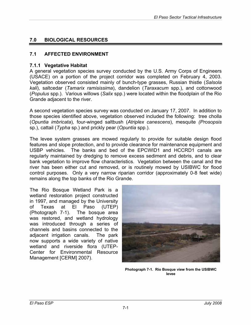
A 7.62-mile section of the fence will be installed north of the irrigation canal on the south side of the EPCWID1 maintenance road, from the east side of the Rio Bosque Wetland Park to the Riverside Canal diversion at the Grijalva Headgates in San Elizario. This alignment is required due to insufficient space for placement of the fence between the canal and the levee.
El Paso Sector Tactical Infrastructure
El Paso ESP July 2008 ES - 3
Floating Foundation Fence Design. The fence will be installed with a “floating foundation”. This design calls for a foundation to be constructed off-site, and the sections of fence foundation will be placed on the top of the levee with little or no ground disturbance other than leveling the top of the levee. Fence will then be added to the completed foundation. A hard surface road will be integrated into this fence design. The lights, bridges and road improvements would be placed as indicated in the Planned Action description. The Floating Foundation Fence Design could be installed interchangeably with the conventional foundation fence design in any portion of the 56.7-mile corridor.
SUMMARY OF ENVIRONMENTAL IMPACTS AND MITIGATION
Table ES-1 provides an overview of potential environmental impacts by specificresource areas. Chapters 3 through 11 of this ESP address these impacts in more detail. CBP followed specially developed design criteria to reduce adverse environmental impacts and will implement mitigation measures to further reduce or offset adverse environmental impacts. Design criteria to reduce adverse environmental impacts included selecting a route that will minimize impacts, consulting with Federal and state agencies and other stakeholders to avoid or minimize adverse environmental impacts, and developing appropriate BMPs to protect natural and cultural resources. BMPs will include implementation of a Storm Water Pollution Prevention Plan (SWPPP), Construction Mitigation and Restoration (CM&R) Plan, Spill Prevention Control and Countermeasures Plan (SPCCP), Dust Control Plan, Fire Prevention and Suppression Plan, and Unanticipated Discovery Plan to protect natural and cultural resources.
The project corridor consists of previously disturbed landscape due to construction of the irrigation canals and the flood control levee. All of the corridor is maintained for vegetation control, and is heavily traveled by maintenance equipment and USBP vehicles. No natural environment exists within the footprint of the project corridor. A narrow, discontinuous natural riparian corridor is present along the Rio Grande south of the project corridor.
There will be no additional impacts on soils, native vegetation, or wildlife habitats. Land use will not change substantially, and no hazardous materials will be impacted. Short term minor impacts on water resources, air quality and noise will occur. Visual aesthetics are already impacted by the existing canals and levee, and no additional substantial impacts will occur. No threatened or endangered species are present in the project corridor, and habitats outside the corridor will not be impacted. No impacts are expected to occur on cultural resources, and coordination with the Texas State Historical Preservation Officer (SHPO) will be undertaken. Table ES-1 provides an overview of potential environmental impacts by specific resource areas. Chapters 3 through 11 of this ESP address these impacts in more detail.
El Paso Sector Tactical Infrastructure
El Paso ESP July 2008 ES - 4
Table ES-1. Summary of Anticipated Environmental Impacts
AFFECTEDRESOURCE
EFFECTS OF THE PLANNED ACTION
BMPs and MITIGATION MEASURES
Air Quality Minor and temporary impacts on air quality during construction.
Construction equipment will be maintained to minimize emissions. Roads and construction areas will be watered to prevent dust generation.
Noise Minor impacts on adjacent residential areas during construction.
Work adjacent to residential areas will be limited to daytime, where practicable.
Land Use, Recreation, Aesthetics
No impacts. None needed.
Water Resources Minor impacts on adjacent canals. One-time water use for construction.
A SWPPP and a SPCCP will be developed and implemented by the contractor. Silt fencing and hay bales will be used to control erosion.
BiologicalResources
Minor impacts during construction, minor restriction of animal movement during operations.
Surveys for migratory bird nests will be conducted prior to construction during the nesting season. Surveys will be conducted for burrowing owls, and owls discovered will be relocated outside of the nesting season. Open holes and trenches will be checked each day for trapped reptiles and mammals. Equipment will be cleaned to prevent transport of invasive plant species material to the construction site. Small animal pass-through sections will be incorporated into the fence design.
Cultural Resources No impacts are anticipated. Excavation activities will be monitored for buried cultural resources. Bridge designs will be coordinated with SHPO.
Health and Safety No impacts are anticipated. Work sites will be barricaded to prevent unauthorized entry or injury. A health and safety plan will be developed and followed by contractors.
El Paso Sector Tactical Infrastructure
El Paso ESP July 2008 i
TABLE OF CONTENTS
EXECUTIVE SUMMARY ........................................................................................ ES - 1 1.0 GENERAL PROJECT DESCRIPTION..............................................................1-1
1.1 INTRODUCTION TO THE ENVIRONMENTAL STEWARDSHIP PLAN.1-11.2 USBP BACKGROUND ...........................................................................1-31.3 GOALS AND OBJECTIVES....................................................................1-41.4 STAKEHOLDER AND PUBLIC OUTREACH..........................................1-41.5 MITIGATION MEASURES AND BMPS ..................................................1-5
1.5.1 Air Quality ....................................................................................1-51.5.2 Noise............................................................................................1-51.5.3 Water Resources .........................................................................1-51.5.4 Biological Resources....................................................................1-61.5.5 Cultural Resources.......................................................................1-61.5.6 Socioeconomics ...........................................................................1-7
2.0 DESCRIPTION OF THE PLANNED ACTION...................................................2-12.1 FLOATING FOUNDATION FENCE ........................................................2-6
3.0 AIR QUALITY....................................................................................................3-13.1 AFFECTED ENVIRONMENT .................................................................3-13.2 ENVIRONMENTAL EFFECTS................................................................3-1
5.0 LAND USE, RECREATION AND AESTHETICS ..............................................5-15.1 AFFECTED ENVIRONMENT .................................................................5-1
5.1.1 Land Use......................................................................................5-15.1.2 Aesthetic and Visual Resources...................................................5-1
5.2 ENVIRONMENTAL EFFECTS................................................................5-15.2.1 Land Use......................................................................................5-15.2.2 Aesthetics and Visual Resources.................................................5-1
6.0 WATER USE AND QUALITY............................................................................6-16.1 AFFECTED ENVIRONMENT .................................................................6-1
6.1.1 Hydrology and Groundwater ........................................................6-16.1.2 Surface Waters and Waters of the U.S. .......................................6-16.1.3 Floodplains...................................................................................6-1
6.2 ENVIRONMENTAL EFFECTS................................................................6-26.2.1 Hydrology and Groundwater ........................................................6-26.2.2 Surface Waters and Waters of the U.S. .......................................6-26.2.3 Floodplains...................................................................................6-2
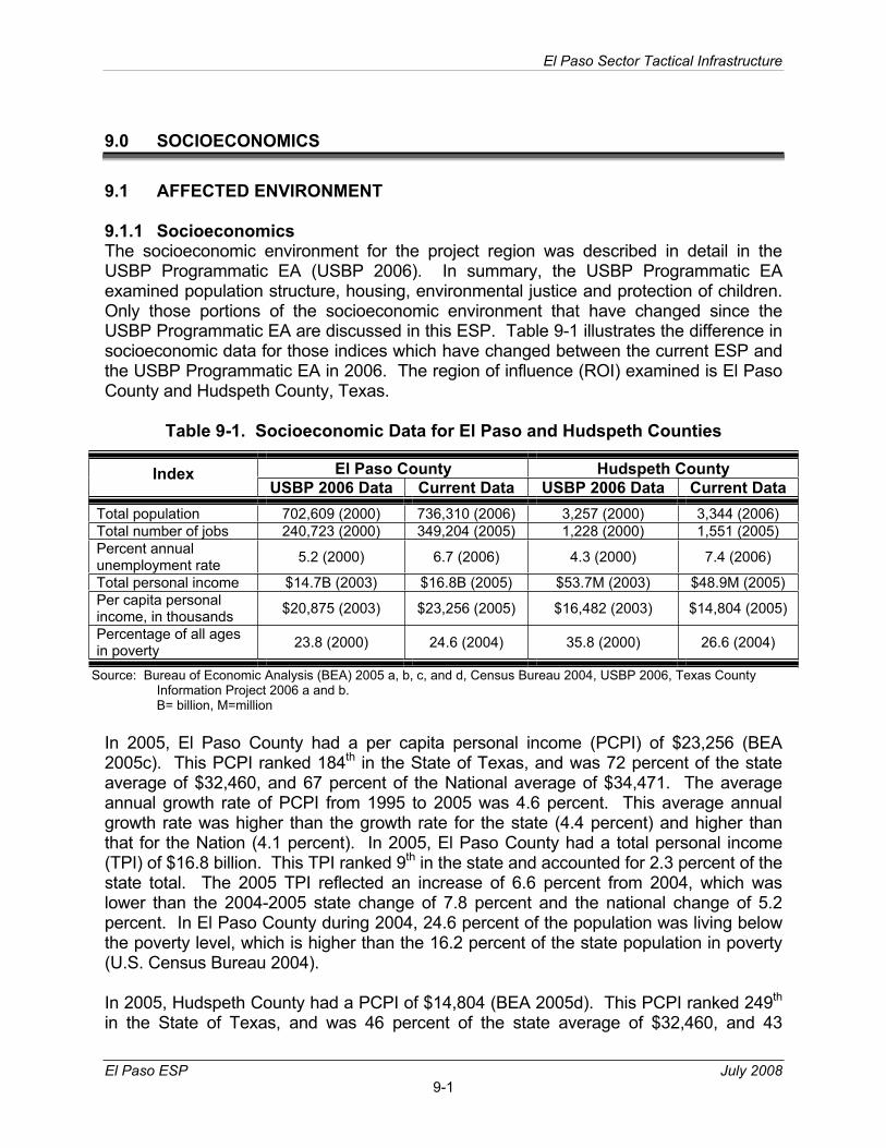
9.1.1 Socioeconomics ...........................................................................9-19.1.2 Environmental Justice ..................................................................9-29.1.3 Protection of Children...................................................................9-29.1.4 Human Health and Safety ............................................................9-2
9.2 ENVIRONMENTAL EFFECTS................................................................9-29.2.1 Socioeconomics ...........................................................................9-39.2.2 Environmental Justice ..................................................................9-39.2.3 Protection of Children...................................................................9-39.2.4 Human Health and Safety ............................................................9-3
10.0 UTILITIES AND INFRASTRUCTURE.............................................................10-110.1 AFFECTED ENVIRONMENT ...............................................................10-110.2 ENVIRONMENTAL EFFECTS..............................................................10-1
12.0 RELATED PROJECTS AND POTENTIAL EFFECTS ....................................12-112.1 AIR QUALITY .......................................................................................12-312.2 NOISE...................................................................................................12-312.3 LAND USE............................................................................................12-3
12.3.1 Aesthetic Resources ..................................................................12-312.4 WATER RESOURCES .........................................................................12-412.5 BIOLOGICAL RESOURCES ................................................................12-4
12.5.1 Native Vegetation.......................................................................12-412.5.2 Wildlife .......................................................................................12-412.5.3 Threatened and Endangered Species and Critical habitat .........12-5
12.6 CULTURAL RESOURCES ...................................................................12-512.7 SOCIOECONOMICS ............................................................................12-5
12.7.1 Human Health and Safety ..........................................................12-5
El Paso Sector Tactical Infrastructure
El Paso ESP July 2008 iii
12.8 UTILITIES AND INFRASTRUCTURE...................................................12-512.9 HAZARDOUS MATERIALS ..................................................................12-5
List of Figures Figure 2-1. Vicinity Map.............................................................................................2-2 Figure 2-2. Typical Schematic Cross Section, Conventional Fence Design..............2-3 Figure 2-3. Schematic Cross-section Diagram-Floating Foundation Fence Design ..2-7Figure 2-4. Project Area Index Map........................................................................... 2-8 Figure 2-4a. Project Area Map .................................................................................... 2-9 Figure 2-4b. Project Area Map .................................................................................. 2-10 Figure 2-4c. Project Area Map .................................................................................. 2-11 Figure 2-4d. Project Area Map .................................................................................. 2-12 Figure 2-4e. Project Area Map .................................................................................. 2-13 Figure 2-4f. Project Area Map .................................................................................. 2-14 Figure 2-4g. Project Area Map .................................................................................. 2-15 Figure 2-4h. Project Area Map .................................................................................. 2-16 Figure 2-4i. Project Area Map .................................................................................. 2-17 Figure 2-4j. Project Area Map .................................................................................. 2-18 Figure 2-4k. Project Area Map .................................................................................. 2-19 Figure 2-4l. Project Area Map .................................................................................. 2-20 Figure 2-4m. Project Area Map .................................................................................. 2-21 Figure 2-4n. Project Area Map .................................................................................. 2-22 Figure 2-4o. Project Area Map .................................................................................. 2-23 Figure 2-4p. Project Area Map .................................................................................. 2-24 Figure 2-4q. Project Area Map .................................................................................. 2-25 Figure 4-1a. Noise Attenuation of Construction Equipment.........................................4-4Figure 4-1b. Noise Attenuation of Construction Equipment......................................... 4-5 Figure 4-1c Noise Attenuation of Construction Equipment......................................... 4-6 Figure 4-1d Noise Attenuation of Construction Equipment......................................... 4-7 Figure 4-1e Noise Attenuation of Construction Equipment......................................... 4-8
List of Tables Table 1-1. Summary Table of Mitigation Measures and BMPs. ..................................1-7Table 2-1. Project Fence Segments for USBP El Paso Sector ...................................2-6Table 3-1. Total Air Emissions (tons/year) from Construction Activities vs. the de
minimis Levels ...........................................................................................3-2Table 4-1. A-Weighted (dBA) Sound Levels of Construction Equipment ....................4-3Table 7-1. Federally Listed Species for El Paso County, Texas..................................7-3Table 9-1. Socioeconomic Data for El Paso and Hudspeth Counties .........................9-1
El Paso Sector Tactical Infrastructure
El Paso ESP July 2008 iv
List of Photographs Photograph 2-1. Typical primary pedestrian fence...................................................... 2-1 Photograph 2-2. Typical bollard-style fence ................................................................ 2-1 Photograph 2-3. Typical floodplain between the levee and the Rio Grande................ 2-5 Photograph 7-1. Rio Bosque view from the USIBWC levee ........................................ 7-1
List of Appendices Appendix A. Copy of 2008 Border Waiver Appendix B. Air Quality Calculations Appendix C. Lighting Specifications and Diagrams
SECTION 1.0GENERAL PROJECT DESCRIPTION
El Paso Sector Tactical Infrastructure
El Paso ESP July 2008 1-1
1.0 GENERAL PROJECT DESCRIPTION
1.1 INTRODUCTION TO THE ENVIRONMENTAL STEWARDSHIP PLAN
In Section 102(b) of the Illegal Immigration Reform and Immigrant Responsibility Act (IIRIRA), Congress mandated that the United States (U.S.) Department of Homeland Security (DHS) install fencing, barriers, roads, lighting, cameras, and sensors on not less than 700 miles of the southwestern border. This total includes certain priority miles of fencing in areas most practical and effective in deterring illegal entry and smuggling into the U.S. Congress has mandated that these priority miles be completed by December 2008. To that end, DHS plans to complete 370 miles of pedestrian fencing and 300 miles of vehicle fencing along the southwestern border by the end of 2008. As of March 21, 2008, 201 miles of primary pedestrian fence and 140 miles of vehicle fence remained to be constructed to meet the December 2008 deadline. These efforts support the U.S. Customs and Border Protection (CBP) mission to prevent terrorists and terrorist weapons from entering the U.S., while also facilitating the flow of legitimate trade and travel.
On April 1, 2008, the Secretary of DHS, pursuant to his authority under Section 102(c) of IIRIRA, exercised his authority to waive certain laws that were an impediment to the expeditious construction of tactical infrastructure (TI) along the southwestern border. TI is a term used by USBP to describe physical structures that facilitate enforcement activities; these items typically include, but are not limited to, roads, fences, lights, gates, bridges, and barriers.
Although the Secretary’s waiver means that CBP no longer has any specific legal obligations under these laws, the Secretary committed the Department to responsible environmental stewardship of our valuable natural and cultural resources. CBP strongly supports this objective and remains committed to being a good steward of the environment. A copy of the waiver is included as Appendix A.
In support of its commitment to environmental stewardship, CBP will continue to work in a collaborative manner with local government, state and Federal land managers, and the interested public to identify environmentally sensitive resources and develop appropriate best management practices (BMPs) to avoid or minimize adverse impacts resulting from the projects.
CBP is conducting an environmental review of the projects and will publish the results of this analysis in Environmental Stewardship Plans (ESPs), including mitigation and BMPs developed to minimize adverse effects on the environment. These ESPs will be developed for each U.S. Border Patrol (USBP) Sector scheduled for tactical infrastructure improvements and will address each segment of pedestrian and vehicle fencing covered by the waiver.
El Paso Sector Tactical Infrastructure
El Paso ESP July 2008 1-2
The project area covered by this ESP has been determined to be an area of high illegal entry into the U.S., and the project area has been designated by the Secretary of DHS as an area of critical border TI. As such, the project area is designated as an area where completion of border TI must be accomplished in an expeditious manner, and the Secretary of DHS has waived compliance with all Federal, state, or other laws, regulations and legal requirements deemed to be an impediment to the completion of the TI (the Planned Action). This ESP is prepared in order to evaluate impacts of the Planned Action on natural and human resources in the project corridor, and to assist CBP and USBP in conserving critical resources during construction and operation of the TI being installed. This ESP is designed in a format that identifies each affected resource and evaluates all potential impacts to that resource. This ESP was not prepared to comply with specific laws or regulations; rather it is a planning and guidance tool to assist CBP to accomplish construction in a manner that will minimize adverse impacts to the extent practicable.
CBP and USBP will construct, maintain, and operate approximately 57 miles of TI along U.S. Section, International Boundary and Water Commission (USIBWC) Rio Grande flood protection levee and county irrigation canals in El Paso and Hudspeth counties, Texas. Some resources within the Planned Action’s region of influence (ROI) are not addressed in this ESP because they are not relevant to the analyses. The resources that are not addressed, and the reasons for eliminating them are:
Physiography: The topography of the project area is generally flat, associated with the floodplain of the Rio Grande. Man-made alterations to the topography consist of the El Paso County Water Improvement District No. 1 (EPCWID1) and Hudspeth County Conservation Reclamation District No. 1 (HCCRD1) canals which are excavated and maintained on the U.S. side of the river, and the USIBWC levee which separates the canals from the Rio Grande floodplain. Practically the entire landscape within the project area is altered to some degree by development. No alteration of the topography of the project area will occur as a result of the Planned Action; therefore, physiographic impacts are not included for further analysis.
Geology and Soils: Geological resources include physical surface and subsurface features of the earth such as geological formations, and the seismic activity of the area. The Planned Action will involve only disturbances to the topsoil layers and, in the case of creating holes for either fence posts or light poles, the impacts will occur to only a very small surface area, not altering the geology of the region. Additionally, all roads being improved within the project corridor are preexisting, and will, therefore, not result in substantial modifications to the area’s topography (i.e., road cuts). There are no critical geologic resources or sensitive seismic areas located in the vicinity of the project corridor; therefore, geologic resources are not included for further analysis.
Soils in the project area consist of fine sandy and silty clay loams associated with the Rio Grande floodplain. All of the soils have been disturbed by canal excavation, levee and road construction, and general grading and leveling of the area around the river and the canals. On the U.S. side of the canal system, the soils are tilled and irrigated in
El Paso Sector Tactical Infrastructure
El Paso ESP July 2008 1-3
rural areas for agricultural crop production. No unique or prime farmland soils are located within the project corridor, and soils in staging areas outside the construction corridor will not be permanently disturbed; therefore, soils and soil impacts are not included for further analysis.
Climate: The Planned Action will not affect or be affected by climate, so climate impacts are not included for further analysis.
Roadways/Traffic: All of the activities associated with the Planned Action will take place on the levees and canals along the U.S./Mexico border, and no activities will take place on public roadways, other than normal transport of goods and personnel on an intermittent basis. Therefore, impacts on roadways and traffic are not included for further analysis.
Communications: The Planned Action will not affect communications systems in the area.
Wild and Scenic Rivers: The Planned Action will not affect any designated Wild and Scenic Rivers because no rivers designated as such are located within or near the project corridor.
1.2 USBP BACKGROUND
The mission of CBP is to prevent terrorists and terrorist weapons from entering the U.S., while also facilitating the flow of legitimate trade and travel. In supporting CBP’s mission, USBP is charged with establishing and maintaining effective control of the borders of the U.S. USBP’s mission strategy consists of five main objectives:
• Establish substantial probability of apprehending terrorists and their weapons as they attempt to enter illegally between the POEs;
• Deter illegal entries through improved enforcement;
• Detect, apprehend, and deter smugglers of humans, drugs, and other contraband;
• Leverage “smart border” technology to multiply the effect of enforcement personnel; and
• Reduce crime in border communities and consequently improve quality of life and economic vitality of targeted areas.
USBP has nine administrative sectors along the U.S./Mexico border. Each sector is responsible for implementing an optimal combination of personnel, technology, and infrastructure appropriate for its operational requirements. The El Paso Sector is responsible for El Paso and Hudspeth counties, Texas and the entire state of New Mexico. The areas affected by the Planned Action include El Paso and Hudspeth counties in Texas along the levees and floodplain of the Rio Grande.
El Paso Sector Tactical Infrastructure
El Paso ESP July 2008 1-4
1.3 GOALS AND OBJECTIVES
The goal of the Planned Action is to increase border security within the USBP El Paso Sector with an ultimate objective of reducing illegal cross-border activity. The Planned Action further meets the objectives of the Congressional direction in the Fiscal Year (FY) 2007 DHS Appropriations Act (Public Law [P.L.] 109-295), Border Security Fencing, Infrastructure, and Technology appropriation to install fencing, infrastructure, and technology along the border.
USBP El Paso Sector has identified areas along the border that experience high levels of illegal cross-border activity. This activity occurs in remote areas adjacent to the Rio Grande that are not easily accessed by USBP agents, near POEs where concentrated populations might live on either side of the border or have quick access to U.S. transportation routes, and in crowded metropolitan areas where IAs can quickly assimilate into the U.S. population.
1.4 STAKEHOLDER AND PUBLIC OUTREACH
Prior to the waiver, CBP prepared a Draft Environmental Assessment (EA) and Draft Finding of No Significant Impact (FONSI) to address the potential effects of the Planned Action. A Notice of Availability (NOA) for the draft EA and FONSI was published in the El Paso Times on 19 and 25 February 2008, announcing the release of documents for a 30-day public comment period. In addition, a public meeting was conducted in El Paso on 28 January 2008.
Although the Secretary of DHS issued the waiver, and thus, CBP has no responsibilities under the National Environmental Policy Act (NEPA) for this project, CBP reviewed, considered, and incorporated comments received from the public and other Federal, state, and local agencies, as appropriate, during the preparation of this ESP. Results of previous public and agency coordination efforts will be available on the Internet at the following URL: www.BorderFencePlanning.com.
In addition to the past public involvement and outreach program, CBP has continued to coordinate with various Federal and state agencies during the development of this ESP. Federal agencies are described in the following paragraphs.
U.S. Section, International Boundary and Water Commission (USIBWC) - CBP has coordinated with USIBWC to ensure that any construction along the international border does not adversely affect International Boundary Monuments or substantially impede floodwater conveyance within international drainages.
U.S. Army Corps of Engineers (USACE), Albuquerque District - CBP has coordinated all activities with USACE to identify potential jurisdictional Waters of the U.S. (WUS), including wetlands, and to develop measures to avoid, minimize or compensate for losses to these resources.
El Paso Sector Tactical Infrastructure
El Paso ESP July 2008 1-5
U.S. Fish and Wildlife Service (USFWS) - CBP has coordinated extensively with USFWS to identify listed species that have the potential to occur in the project area and have cooperated with the USFWS to identify potential effects on listed species and develop best management practices (BMPs) which could be implemented.
1.5 MITIGATION MEASURES AND BMPS
It is CBP’s policy to reduce impacts through the sequence of avoidance, minimization, mitigation, and finally, compensation. Mitigation efforts vary and include activities such as restoration of habitat in other areas and implementation of appropriate BMPs. CBP coordinates its environmental design measures with the appropriate Federal and state resource agencies, as appropriate. Both general BMPs and project- or species-specific BMPs have been developed during the preparation of this ESP.
This section describes those measures that may be implemented to reduce or eliminate potential adverse impacts on the human and natural environment. Many of these measures have been incorporated by CBP as standard operating procedures on past projects. Environmental design measures and BMPs are presented for each resource category that will be potentially affected. The mitigation measures will be coordinated with the appropriate agencies and land managers or administrators, as appropriate.
1.5.1 Air Quality During the construction of the Planned Action, proper and routine maintenance of all vehicles and other construction equipment will be implemented by the contractor such that emissions are within the design standards of all construction equipment. Dust suppression methods, such as watering of roads and construction areas, will be implemented to minimize fugitive dust.
1.5.2 Noise Construction activities will be limited to daytime hours near residential areas, to the extent practicable.
1.5.3 Water Resources BMPs will be implemented as standard operating procedures during all construction activities, and will include proper handling, storage, and/or disposal of hazardous and/or regulated materials. To minimize potential impacts to surface waters from hazardous and regulated materials, all fuels, waste oils, and solvents will be collected and stored in tanks or drums within a secondary containment system that consists of an impervious floor and bermed sidewalls capable of containing the volume of the largest container stored therein. The refueling of machinery will be completed following accepted industry guidelines, and all vehicles will have drip pans during storage to contain minor spills and drips. Although a major spill is unlikely to occur, any spill of reportable quantities will be contained immediately within an earthen dike, and the application of an absorbent (e.g., granular, pillow, sock, etc.) will be used to absorb and contain the spill.
El Paso Sector Tactical Infrastructure
El Paso ESP July 2008 1-6
A Spill Prevention, Control, and Countermeasures Plan (SPCCP) will be in place prior to the start of operations, and all personnel will be briefed on the implementation and responsibilities of this plan. All spills will be reported to the designated USBP point of contact for the Project. Furthermore, a spill of any regulated substance in a reportable quantity will be cleaned up and coordinated with the appropriate Federal and state agencies. Reportable quantities of regulated substances will be included as part of the project-specific SPCCP. Additionally, all construction activities will follow DHS Management Directive 5100 for waste management.
All equipment maintenance, laydown, and dispensing of fuel, oil, or any other such activities, will occur in staging areas identified for use in the Planned Action description. The designated staging areas will be located in such a manner as to prevent any runoff from entering waters of the United States, including wetlands. All used oil and solvents will be recycled if possible. All non-recyclable hazardous and regulated wastes will be collected, characterized, labeled, stored, transported, and disposed in manners consistent with U.S. Environmental Protection Agency (EPA) standards.
Solid waste receptacles will be maintained at staging areas, and non-hazardous solid waste (trash and waste construction materials) will be collected and deposited in on-site receptacles. Waste materials and other discarded materials contained in these receptacles will be removed from the site as quickly as possible. Solid waste will be collected and disposed of properly.
A Storm Water Pollution Prevention Plan (SWPPP) will be developed by the project contractor for the area affected during construction procedures. The SWPPP will include BMPs to control erosion and fugitive dust emissions, including the use of silt fencing and hay bales adjacent to open water, such as the canals, and dust suppression by watering haul roads and construction areas.
1.5.4 Biological Resources Since construction or clearing activities cannot be scheduled to avoid the migratory bird nesting season (typically February 15 through September 15), surveys will be performed to identify active nests. If construction activities will result in the take of a migratory bird, then appropriate mitigation measures will be implemented to minimize impacts. Monitoring for the presence of burrowing owls in the sides of the levee will be conducted, and relocation of owls present will be accomplished outside of the nesting season, to the extent practicable. Monitoring of open post holes and trenches will take place daily to reduce or avoid impacts on Texas horned lizards and other small animals. In addition, small animal pass-through gaps will be included in the bottom of the fence to facilitate migration between the floodplain and lands to the north of the levee.
1.5.5 Cultural Resources All excavation activities will be monitored for possible buried cultural resources. Although no buried cultural resources are known within the project areas, should any evidence of cultural resources be observed during construction, work will stop in the immediate
El Paso Sector Tactical Infrastructure
El Paso ESP July 2008 1-7
vicinity, the resource will be protected, coordination with SHPO will be conducted, and a mitigation plan will be developed and implemented if necessary.
Light switches will be installed, as specified in a Memorandum of Agreement (MOA) with the Ysleta del Sur Pueblo, so that lights can be turned off when necessary during tribal ceremonies along the river. Access to the river will be provided with gates in the fence at prescribed intervals.
1.5.6 Socioeconomics A health and safety plan will be developed by the contractor prior to construction to direct construction activities in accordance with Office of Safety and Health Administration(OSHA) requirements. Construction sites will be barricaded to prevent unauthorized entry.
Fence designs will be coordinated with USIBWC, EPCWID1 and HCCRD1 so that fence footings will not be constructed in any ways that could compromise the levee or irrigation canal structural integrity.
Table 1-1. Summary Table of Mitigation Measures and BMPs
AffectedResource Mitigation and BMPs Planned
Air Quality Dust suppression will be implemented during construction to include: watering of roads and disturbed soils and application of stabilization agents to finished roads. Equipment will be maintained to prevent excessive combustion exhaust emissions.
Noise Construction in the vicinity of occupied dwellings will be conducted during daylight hours to the extent practicable.
WaterResources
A SWPPP will be developed by the contractor, approved by CBP, and implemented during construction to prevent erosion of soils. The SWPPP will include BMPs such as: silt fencing and hay bale placement to prevent soil movement into adjacent water bodies. A SPCCP will be developed by the contractor, approved by CBP, and implemented during construction to prevent hazardous materials spills.
Biological Resources
The fence will incorporate small animal pass-through openings at the base every 150 feet of length as necessary. Surveys for migratory bird nesting will be conducted as necessary between February 15 and September 15 prior to construction. Open holes and trenches will be checked at the start of each construction day, and any trapped reptiles or other animals will be removed. Burrows in the levee will be checked for burrowing owls if construction occurs between March 1 and September 1, and non-nesting birds will be relocated if possible. Equipment will be cleaned prior to entering the work area to prevent introduction of non-native seeds and plant materials. Fill dirt will also be checked for presence of non-native species.Permanent lights will be shielded and directed to prevent excess lighting of areas north of the levee.
El Paso Sector Tactical Infrastructure
El Paso ESP July 2008 1-8
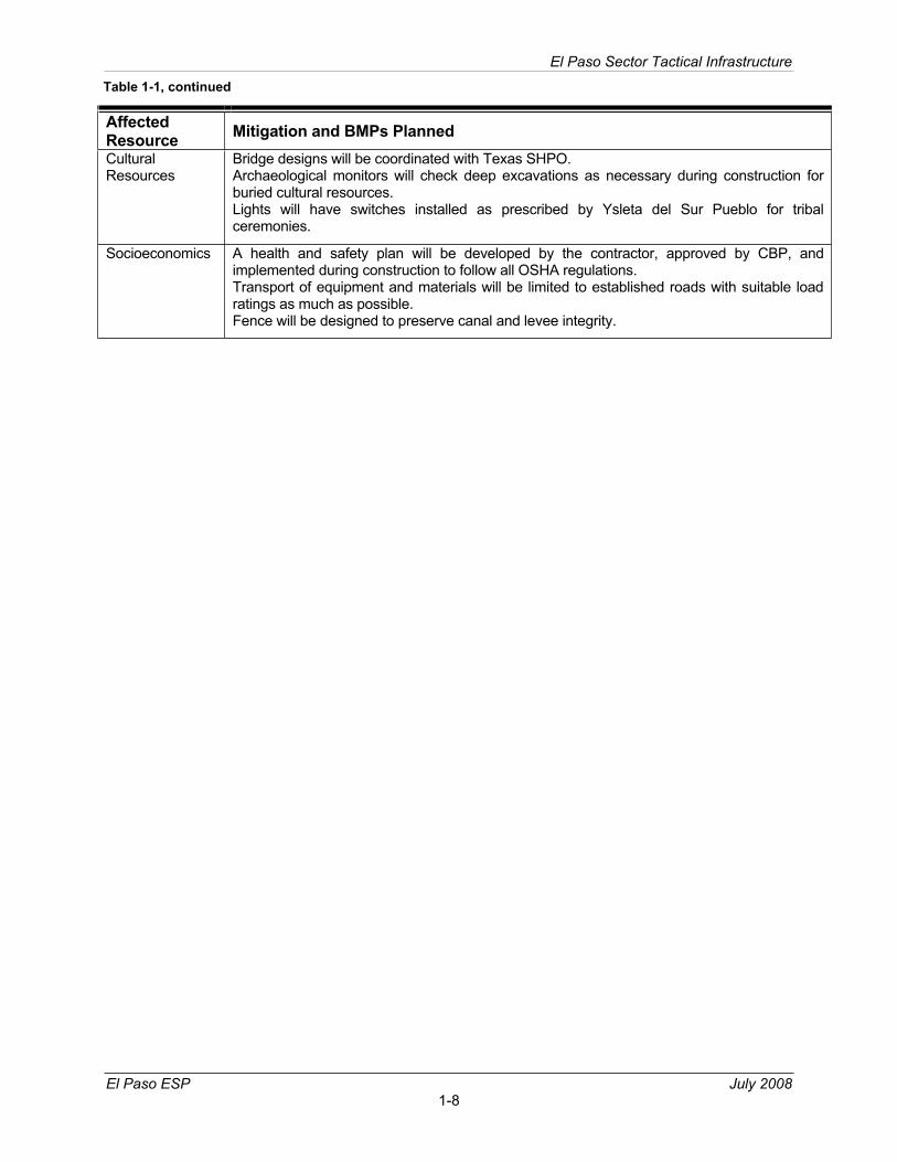
AffectedResource Mitigation and BMPs Planned CulturalResources
Bridge designs will be coordinated with Texas SHPO. Archaeological monitors will check deep excavations as necessary during construction for buried cultural resources. Lights will have switches installed as prescribed by Ysleta del Sur Pueblo for tribal ceremonies.
Socioeconomics A health and safety plan will be developed by the contractor, approved by CBP, and implemented during construction to follow all OSHA regulations. Transport of equipment and materials will be limited to established roads with suitable load ratings as much as possible. Fence will be designed to preserve canal and levee integrity.
Table 1-1, continued
SECTION 2.0DESCRIPTION OF THE PLANNED ACTION
El Paso Sector Tactical Infrastructure
El Paso ESP July 2008 2-1
Photograph 2-2. Typical bollard-style fence
Photograph 2-1. Typical primary pedestrian fence
2.0 DESCRIPTION OF THE PLANNED ACTION
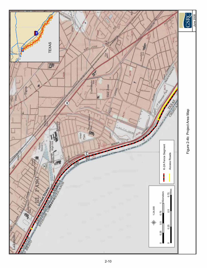
A primary pedestrian fence, similar to that shown in Photograph 2-1, will be installed for approximately 56.7 miles on the north (protected) side of the USIBWC levee, from a point near the east boundary of Modesto Gomez Park in El Paso to a point 3.7 miles east of the Fort Hancock POE (Figure 2-1). Existing chain link fence will be replaced with primary pedestrian fence for the portion of the project length identified as K-2A (see Figures 2-4a through 2-4d at the end of this section).
In some areas, a bollard-style fence may be installed as shown in Photograph 2-2. Fence installation will involve excavation and ground disturbance, and the fence will be constructed with a conventional concrete foundation along the entire length of the project corridor. Based upon performance specifications established at the time of construction, fence placement will be similar to the design shown in Figure 2-2. Gates will be installed in the fence at canal bridge locations and at set intervals for for ingress/egress of USBP agents and USIBWC personnel and emergency rescues within the canal and the Rio Grande.
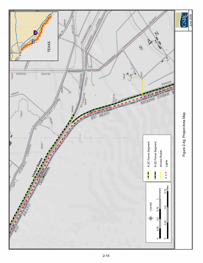
A 7.62-mile section of the fence will be installed north of the irrigation canal on the south side of the EPCWID1 maintenance road, from the east side of the Rio Bosque Wetland Park to the Riverside Canal diversion at the Grijalva Headgates in San Elizario. This alignment is required due to insufficient space for placement of the fence between the canal and the levee.
HUDSPETHCOUNTY
EL PASOCOUNTY
DONA ANACOUNTY
OTEROCOUNTY
Franklin Drain
Tornillo Canal
IslandDrain
Rio Grande
NEWMEXICO
375
Riverside Canal
Fabens POE
El Paso
Fabens
Tornillo
Chaparral
Fort Hancock POE
Zaragosa POE
Bridge of theAmericas POE
Fort BlissFort Bliss
μ 1:450,000
MEXICO
0 5 10 15 20Miles
0 5 10 15 20Kilometers
!(
TEXAS
Figure 2-1: Vicinity Map
El PasoCounty
January 2008
Project Location
2-2
£¤62
£¤54
§̈¦10
£¤85
KK KK KK KK KK KK
CAN
AL
FENCE
RO
AD U
SIBW
CLE
VEE
TRAN
SFO
RM
ERTO
RIO
GR
AND
E
FLO
OD
PLA
IN
LIGHT
Figu
re2-
2: T
ypic
al S
chm
atic
Cro
ss S
ectio
n, C
onve
ntio
nal F
ence
Des
ign
Janu
ary
2008
2-3
El Paso Sector Tactical Infrastructure
El Paso ESP July 2008 2-4
CBP will be responsible for maintenance of the fence. There will be no change in overall USBP Sector operations. The fences will be made from non-reflective steel, and no painting will be necessary. Fence maintenance will include removing any accumulated debris on the fence after a rain event to avoid potential future flooding. Sand that builds up against the fence and brush will also be removed as needed. Brush removal could include mowing, removal of small trees and application of herbicide if needed. Any destruction or breaches of the fence will be repaired, as needed.
The fence will meet the following performance measures:
• extend 15 to 18 feet above ground and have sufficient foundation below ground;
• be capable of withstanding an impact from a 10,000-pound gross weight vehicle traveling at 40 miles per hour (mph);
• be resistant to vandalism, cutting, or penetrating;
• be semi-transparent, as dictated by operational need;
• be designed to survive extreme climate changes of a desert environment;
• not impede the natural flow of water; and
• incorporate a small animal pass-through area at the base of the fence.
Lights will be installed within the project corridor for a distance of approximately 21 miles along the USIBWC levee from the end of the Phase II Project near the City of El Paso water treatment plant at Rio Bosque Wetland Park to a point 1 mile east of the Fabens POE. The light standards will be steel poles approximately 45 feet high and installed at the south toe (flood side) of the USIBWC levee, within the floodplain. Transformers will be placed on the ground near the top of the levee on the south side, and six metal bollards, approximately 4 feet high, will be installed for protection. El Paso Electric (EPE) will install the poles, lights, and transformers. Sections of the lights will be fitted with a switch so that lights could be turned off during Ysleta del Sur Pueblo Tribal ceremonies. The lights for Phase II were described in a MOA with USIBWC, and a similar MOA will be executed between USBP and USIBWC for the fence and lighting included in the Planned Action.
The lights will be dual 1000-watt high pressure sodium (HPS) or metal halide lights installed at 150-foot intervals and directed toward the river with shielding to prevent illumination of areas north of the levee. The power lines will be underground with the possible exception of any lateral feeds from the local grid. The locations of these lateral feeds are not known at present. EPE will be responsible for installing the power lines and connections to the existing grid, and for the maintenance of the lights and light standards.
El Paso Sector Tactical Infrastructure
El Paso ESP July 2008 2-5
Photograph 2-3. Typical floodplain between the levee and the Rio Grande
Portable lights will be installed at various locations along the entire project corridor during the construction period for equipment and personnel security and to allow for nighttime construction as needed.
In addition, approximately 2 miles of road improvements will be constructed on levee/ditch bank roads that are owned by the EPCWID1 and others. The roads are currently dirt roads, and become impassable during inclement weather. The roads are integral access points and patrol roads for USBP near the center of the project corridor. The planned improvements will entail grading/leveling and application of an all-weather aggregate surface. CBP will be responsible for maintenance of the all-weather surface on the roads once the improvements are made.
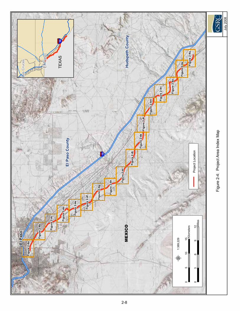
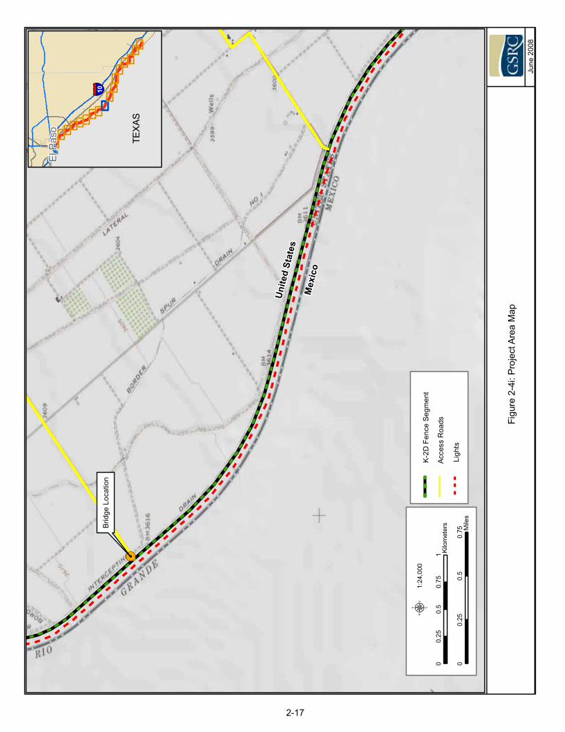
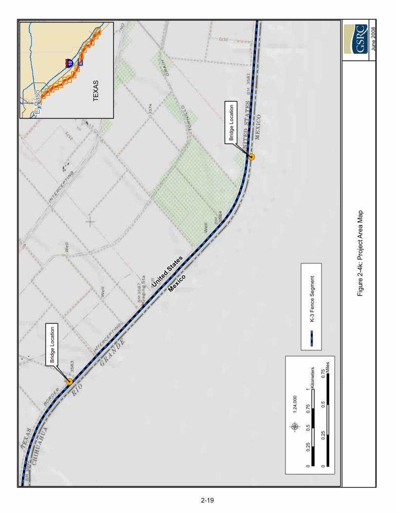
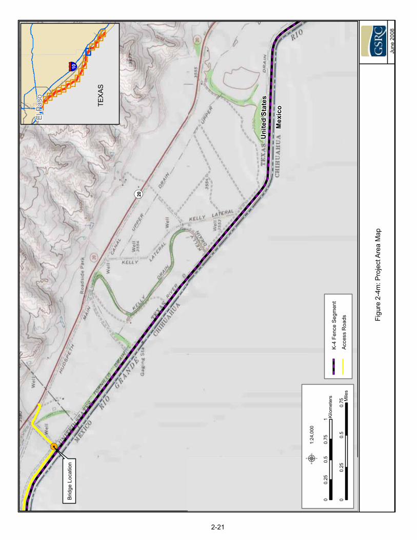
Up to eight bridges will be installed over the EPCWID1 and HCCRD1 irrigation canals at locations shown in Figures 2-4a through 2-4q at the end of this section. These bridges will be designed to extend across the canal with no structures or pilings within the canal, and will not involve substantial ground disturbance. Some locations for the new bridges are the sites of previous canal bridges, which have been destroyed or removed for various reasons. The bridges will provide additional access points to the USIBWC levee and Rio Grande floodplain, and enhance the response time of USBP agents. This will facilitate an increased apprehension rate for IAs in the area and provide enhanced response time for IA rescue in the Rio Grande floodplain during times of high water, when many IAs attempt to cross the river.
As part of the construction efforts for the fence and lights installation, temporary turnarounds and staging areas will be used approximately every mile along the project corridor between the USIBWC levee and the Rio Grande (Photograph 2-3). Approximately 40 10,000 square foot staging areas will be located adjacent to the flood side of the levee on previously disturbed sites, as much as possible. Additional staging areas will be located north of the levee on private lands for the purpose of staging equipment and maintenance activities.
An approximately 2-acre staging area will be temporarily disturbed at the south end of each bridge location. Figures 2-4a through 2-4q at the end of this section show the location of the project components on topographic maps of the project corridor.
El Paso Sector Tactical Infrastructure
El Paso ESP July 2008 2-6
The project corridor is divided into sections, designated K-2A through K-5, to identify contract and construction sections, as shown in Table 2-1.
Table 2-1. Project Fence Segments for USBP El Paso Sector
MapNumber
Border Patrol Station General Location Land
Ownership Length (mi) of
Fence Segment
K-2A El Paso/Ysleta El Paso, east of Modesto Gomez Park to Socorro Headgates
USIBWC 9.62
K-2B Ysleta Socorro Headgates to east end of Rio Bosque USIBWC 2.31
K-2C Ysleta/Fabens East end of Rio Bosque to Grijalva Headgates EPCWID1 7.62
K-2D Fabens Grijalva Headgates to 1.41 miles east of Fabens POE USIBWC 9.47
K-3 Fabens 1.41 miles west of Fabens POE to 7.61 miles east of Fabens POE
USIBWC 8.98
K-4 Fabens/Fort Hancock
7.61 miles east of Fabens POE to 1.5 miles west of Ft. Hancock POE
USIBWC 13.48
K-5 Fort Hancock 1.5 miles west of Ft. Hancock POE to 3.71 miles east of Ft. Hancock POE
USIBWC 5.21
Total 56.68
2.1 FLOATING FOUNDATION FENCE
This alternative design will install a fence constructed to the same performance specifications as the conventional fence described above. The fence will be pre-fabricated in modular sections off-site, and will be transported in sections to the work site, and placed and secured along the top of the levee with no ground disturbance other than leveling the surface for placement. A road parallel to the fence will be cast into each modular foundation segment, and will be integral to the design. The lights, bridges and road improvements will occur as described previously. A schematic diagram of the Floating Foundation Fence design is shown in Figure 2-3. The included hard surface road may limit use of some USIBWC equipment and may limit vehicle ingress and egress from the road due to its location on top of the levee. CBP may implement this alternative design at some point in the future, and the Floating Foundation Fence could be used interchangeably with the conventional fence design, as necessary, in any section of the project corridor.
KK KK KK KK KK KK
CAN
AL
USI
BWC
LEVE
E
TRAN
SFO
RM
ERTO
RIO
GR
AND
E
FLO
OD
PLA
IN
LIGHT
RO
AD
FEN
CE
Figu
re2-
3: T
ypic
al S
chm
atic
Cro
ss S
ectio
n, F
loat
ing
Foun
datio
n Fe
nce
Des
ign
Janu
ary
2008
2-7
Figu
re2-
4i
Figu
re2-
4j
Figu
re2-
4l
Figu
re2-
4f
Figu
re2-
4a
Figu
re2-
4e
Figu
re2-
4c
Figu
re2-
4b
Figu
re2-
4p
Figu
re2-
4k
Figu
re2-
4g
Figu
re2-
4n
Figu
re2-
4d
Figu
re2-
4q
Figu
re2-
4o
Figu
re2-
4h
Figu
re2-
4m
Figu
re2-
4:Pr
ojec
tAre
aIn
dex
Map
July
2008
ElP
aso
Las
Cru
ces
10
03
69
12M
iles
05
1015
Kilo
met
ers
1:38
9,22
9
TEX
AS
Proj
ectL
ocat
ion
MEXICO
ElPa
so
ElPa
soC
ount
y
Hud
spet
hC
ount
y
10
2-8
Figu
re2-
4a:P
roje
ctAr
eaM
ap
June
2008
ElP
aso
§̈ ¦10
00.
250.
50.
75 Mile
s
00.
250.
50.
751 Ki
lom
eter
s
1:24
,000
μ
TEX
AS
K-2A
Fenc
eS
egm
ent
Acce
ssR
oads
§̈ ¦10
§̈ ¦110
£ ¤62
¬ «20
¬ «375
£ ¤54
Mex
ico
Uni
ted
Stat
es
2-9
Brid
geof
the
Amer
icas
PO
E
Figu
re2-
4b:P
roje
ctAr
eaM
ap
June
2008
ElP
aso
§̈ ¦10
00.
250.
50.
75 Mile
s
00.
250.
50.
751 Ki
lom
eter
s
1:24
,000
μ
TEX
AS
K-2A
Fenc
eS
egm
ent
Acce
ssR
oads
¬ «20
¬ «375
Mex
ico
Unite
dSt
ates
2-10
Figu
re2-
4c:P
roje
ctAr
eaM
ap
June
2008
ElP
aso
§̈ ¦10
00.
250.
50.
75 Mile
s
00.
250.
50.
751 Ki
lom
eter
s
1:24
,000
μ
TEX
AS
K-2A
Fenc
eS
egm
ent
Acce
ssR
oads
Stag
ing
Are
as
¬ «20
¬ «375
Mexico
Unite
dSt
ates
2-11
Zara
gosa
PO
E
Figu
re2-
4d:P
roje
ctAr
eaM
apJu
ne20
08
ElP
aso
§̈ ¦10
00.
250.
50.
75 Mile
s
00.
250.
50.
751 Ki
lom
eter
s
1:25
,557
μ
TEX
AS
K-2A
Fenc
eS
egm
ent
Acce
ssR
oads
Stag
ing
Are
as
K-2B
Fenc
eS
egm
ent
Ligh
ts
MexicoUnited States
¬ «258
2-12
K-2C
Fenc
eSe
gmen
t
!.
Brid
geLo
catio
n
Figu
re2-
4e:P
roje
ctAr
eaM
ap
June
2008
ElP
aso
§̈ ¦10
00.
250.
50.
75 Mile
s
00.
250.
50.
751 Ki
lom
eter
s
1:24
,000
μ
TEX
AS
K-2C
Fenc
eSe
gmen
t
Ligh
ts
MexicoUnited States
¬ «258
2-13
!.
Brid
geLo
catio
n
Figu
re2-
4f:P
roje
ctAr
eaM
ap
June
2008
ElP
aso
§̈ ¦10
00.
250.
50.
75 Mile
s
00.
250.
50.
751 Ki
lom
eter
s
1:24
,000
μ
TEX
AS
Acce
ssR
oads
K-2C
Fenc
eSe
gmen
t
Ligh
ts
Mexico
United States
2-14
Figu
re2-
4g:P
roje
ctAr
eaM
ap
June
2008
ElP
aso
§̈ ¦10
00.
250.
50.
75 Mile
s
00.
250.
50.
751 Ki
lom
eter
s
1:24
,000
μ
TEX
AS
Acce
ssR
oads
K-2D
Fenc
eSe
gmen
t
Ligh
ts
Mex
ico
Unite
dSt
ates
2-15
K-2C
Fenc
eSe
gmen
t
!.
Brid
geLo
catio
n
Figu
re2-
4h:P
roje
ctAr
eaM
ap
June
2008
ElP
aso
§̈ ¦10
TEX
AS
K-2D
Fenc
eSe
gmen
t
Ligh
ts0
0.25
0.5
0.75 M
iles
00.
250.
50.
751 Ki
lom
eter
s
1:24
,000
μ
MexicoUnite
d States
2-16
!.
Brid
geLo
catio
n
Figu
re2-
4i:P
roje
ctAr
eaM
ap
June
2008
ElP
aso
§̈ ¦10
00.
250.
50.
75 Mile
s
00.
250.
50.
751 Ki
lom
eter
s
1:24
,000
μ
TEX
AS
Acce
ssR
oads
K-2D
Fenc
eSe
gmen
t
Ligh
ts
Mex
ico
Uni
ted
Stat
es
2-17
Figu
re2-
4j:P
roje
ctAr
eaM
ap
June
2008
ElP
aso
§̈ ¦10
00.
250.
50.
75 Mile
s
00.
250.
50.
751 Ki
lom
eter
s
1:24
,000
μ
TEX
AS
K-3
Fenc
eSe
gmen
t
Stag
ing
Are
as
K-2D
Fenc
eSe
gmen
t
Ligh
ts
Mex
ico
Unite
dSt
ates
Fabe
nsP
OE
¬ «76
U V1109
2-18
!.
!.
Figu
re2-
4k:P
roje
ctAr
eaM
ap
June
2008
ElP
aso
§̈ ¦10
00.
250.
50.
75 Mile
s
00.
250.
50.
751 Ki
lom
eter
s
1:24
,000
μ
TEX
AS
K-3
Fenc
eSe
gmen
t
Brid
geLo
catio
n
Brid
geLo
catio
n
MexicoUnite
d States
2-19
Figu
re2-
4l:P
roje
ctAr
eaM
ap
June
2008
ElP
aso
§̈ ¦10
00.
250.
50.
75 Mile
s
00.
250.
50.
751 Ki
lom
eter
s
1:24
,000
μ
TEX
AS
K-3
Fenc
eSe
gmen
t
Acce
ssR
oads
!.
Brid
geLo
catio
n
Mex
ico
Uni
ted
Stat
e s
¬ «20
2-20
K-4
Fenc
eSe
gmen
t
Figu
re2-
4m:P
roje
ctAr
eaM
ap
June
2008
ElP
aso
§̈ ¦10
TEX
AS
K-4
Fenc
eSe
gmen
t
Acce
ssR
oads
!.
Brid
geLo
catio
n
Mex
ico
Uni
t ed
S tat
es
¬ «20
00.
250.
50.
75 Mile
s
00.
250.
50.
751 Ki
lom
eter
s
1:24
,000
μ
2-21
Figu
re2-
4n:P
roje
ctAr
eaM
apJu
ne20
08
ElP
aso
§̈ ¦10
00.
250.
50.
75 Mile
s
00.
250.
50.
751 Ki
lom
eter
s
1:24
,000
μ
TEX
AS
K-4
Fenc
eSe
gmen
t
MexicoUnited States
¬ «20
2-22
Figu
re2-
4o:P
roje
ctAr
eaM
ap
June
2008
ElP
aso
§̈ ¦10
00.
250.
50.
75 Mile
s
00.
250.
50.
751 Ki
lom
eter
s
1:24
,000
μ
TEX
AS
K-4
Fenc
eSe
gmen
t
Acce
ssR
oads
Alam
oAr
royo
¬ «20
Mex
ico
Uni
ted
Stat
es
2-23
Figu
re2-
4p:P
roje
ctAr
eaM
ap
June
2008
ElP
aso
§̈ ¦10
TEX
AS
K-4
Fenc
eSe
gmen
t
Stag
ing
Are
as
K-5
Fenc
eSe
gmen
tMexicoUnite
d States
¬ «20
Fort
Han
cock
PO
E
2-24
00.
250.
50.
75 Mile
s
00.
250.
50.
751 Ki
lom
eter
s
1:24
,000
μ
Figu
re2-
4q:P
roje
ctAr
eaM
ap
June
2008
ElP
aso
§̈ ¦10
TEX
AS
Acce
ssR
oads
Stag
ing
Are
as
K-5
Fenc
eSe
gmen
t
MexicoUnited States
2-25
00.
250.
50.
75 Mile
s
00.
250.
50.
751 Ki
lom
eter
s
1:24
,000
μD
iabl
oAr
royo
El Paso Sector Tactical Infrastructure
El Paso ESP July 2008 2-26
THIS PAGE LEFT INTENTIONALLY BLANK
SECTION 3.0AIR QUALITY
El Paso Sector Tactical Infrastructure
El Paso ESP July 2008 3-1
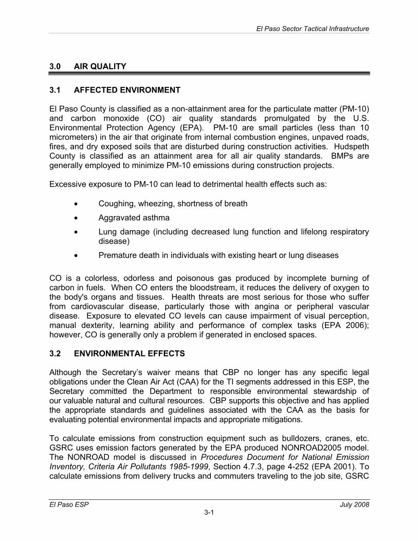
3.0 AIR QUALITY
3.1 AFFECTED ENVIRONMENT
El Paso County is classified as a non-attainment area for the particulate matter (PM-10) and carbon monoxide (CO) air quality standards promulgated by the U.S. Environmental Protection Agency (EPA). PM-10 are small particles (less than 10 micrometers) in the air that originate from internal combustion engines, unpaved roads, fires, and dry exposed soils that are disturbed during construction activities. Hudspeth County is classified as an attainment area for all air quality standards. BMPs are generally employed to minimize PM-10 emissions during construction projects.
Excessive exposure to PM-10 can lead to detrimental health effects such as:
• Coughing, wheezing, shortness of breath
• Aggravated asthma
• Lung damage (including decreased lung function and lifelong respiratory disease)
• Premature death in individuals with existing heart or lung diseases
CO is a colorless, odorless and poisonous gas produced by incomplete burning of carbon in fuels. When CO enters the bloodstream, it reduces the delivery of oxygen to the body's organs and tissues. Health threats are most serious for those who suffer from cardiovascular disease, particularly those with angina or peripheral vascular disease. Exposure to elevated CO levels can cause impairment of visual perception, manual dexterity, learning ability and performance of complex tasks (EPA 2006); however, CO is generally only a problem if generated in enclosed spaces.
3.2 ENVIRONMENTAL EFFECTS
Although the Secretary’s waiver means that CBP no longer has any specific legal obligations under the Clean Air Act (CAA) for the TI segments addressed in this ESP, the Secretary committed the Department to responsible environmental stewardship of our valuable natural and cultural resources. CBP supports this objective and has applied the appropriate standards and guidelines associated with the CAA as the basis for evaluating potential environmental impacts and appropriate mitigations.
To calculate emissions from construction equipment such as bulldozers, cranes, etc. GSRC uses emission factors generated by the EPA produced NONROAD2005 model. The NONROAD model is discussed in Procedures Document for National Emission Inventory, Criteria Air Pollutants 1985-1999, Section 4.7.3, page 4-252 (EPA 2001). To calculate emissions from delivery trucks and commuters traveling to the job site, GSRC
El Paso Sector Tactical Infrastructure
El Paso ESP July 2008 3-2
uses emission factors generated by EPA produced MOBILE6.2. The MOBILE model is discussed in Section 4.6.4, page 4-199.
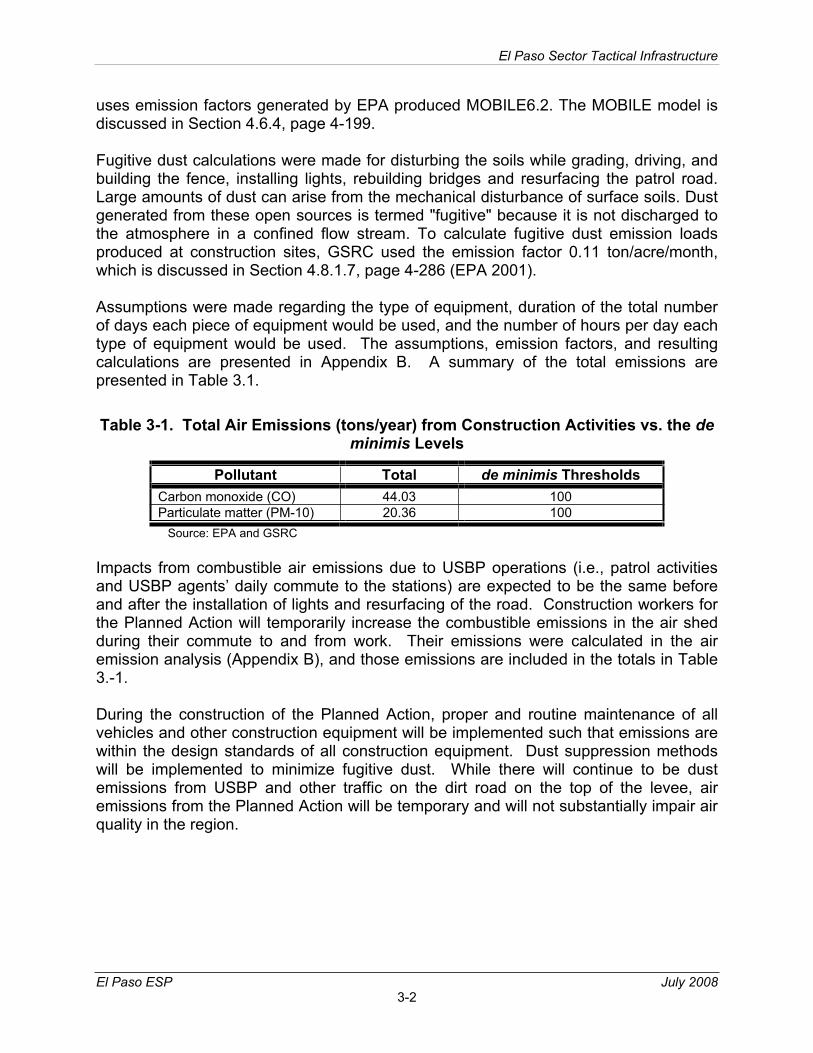
Fugitive dust calculations were made for disturbing the soils while grading, driving, and building the fence, installing lights, rebuilding bridges and resurfacing the patrol road. Large amounts of dust can arise from the mechanical disturbance of surface soils. Dust generated from these open sources is termed "fugitive" because it is not discharged to the atmosphere in a confined flow stream. To calculate fugitive dust emission loads produced at construction sites, GSRC used the emission factor 0.11 ton/acre/month, which is discussed in Section 4.8.1.7, page 4-286 (EPA 2001).
Assumptions were made regarding the type of equipment, duration of the total number of days each piece of equipment would be used, and the number of hours per day each type of equipment would be used. The assumptions, emission factors, and resulting calculations are presented in Appendix B. A summary of the total emissions are presented in Table 3.1.
Table 3-1. Total Air Emissions (tons/year) from Construction Activities vs. the deminimis Levels
Pollutant Total de minimis Thresholds Carbon monoxide (CO) 44.03 100 Particulate matter (PM-10) 20.36 100
Source: EPA and GSRC
Impacts from combustible air emissions due to USBP operations (i.e., patrol activities and USBP agents’ daily commute to the stations) are expected to be the same before and after the installation of lights and resurfacing of the road. Construction workers for the Planned Action will temporarily increase the combustible emissions in the air shed during their commute to and from work. Their emissions were calculated in the air emission analysis (Appendix B), and those emissions are included in the totals in Table 3.-1.
During the construction of the Planned Action, proper and routine maintenance of all vehicles and other construction equipment will be implemented such that emissions are within the design standards of all construction equipment. Dust suppression methods will be implemented to minimize fugitive dust. While there will continue to be dust emissions from USBP and other traffic on the dirt road on the top of the levee, air emissions from the Planned Action will be temporary and will not substantially impair air quality in the region.
SECTION 4.0NOISE
El Paso Sector Tactical Infrastructure
El Paso ESP July 2008 4-1
4.0 NOISE
4.1 AFFECTED ENVIRONMENT
Noise is generally described as unwanted sound, which can be based either on objective effects (i.e., hearing loss, damage to structures, etc.) or subjective judgments (e.g., community annoyance). Sound is usually represented on a logarithmic scale with a unit called the decibel (dB). Sound on the decibel scale is referred to as sound level. The threshold of human hearing is approximately 0 dB, and the threshold of discomfort or pain is around 120 dB.
Noise levels occurring at night generally produce a greater annoyance than do the same levels occurring during the day. It is generally agreed that people perceive intrusive noise at night as being 10 dBA (A-weighted decibel is a measure of noise at a given, maximum level or constant state level) louder than the same level of intrusive noise during the day, at least in terms of its potential for causing community annoyance. This perception is largely because background environmental sound levels at night in most areas are also about 10 dBA lower than those during the day.
Acceptable noise levels have been established by the U.S. Department of Housing and Urban Development (HUD) for construction activities in residential areas:
• Acceptable (not exceeding 65 dB) – The noise exposure may be of some concern but common building construction will make the indoor environment acceptable and the outdoor environment will be reasonably pleasant for recreation and play.
• Normally Unacceptable (above 65 but not greater than 75 dB) – The noise exposure is substantially more severe; barriers may be necessary between the site and prominent noise sources to make the outdoor environment acceptable, and; special building constructions may be necessary such that people indoors are sufficiently insulated from outdoor noise.
• Unacceptable (greater than 75 dB) – The noise exposure at the site is so severe that the construction costs to make the indoor noise environment acceptable may be prohibitive and the outdoor environment would still be unacceptable.
As a general rule of thumb, noise generated by a stationary noise source, or “point source,” will decrease by approximately 6dB over hard surfaces and 9dB over soft surfaces for each doubling of the distance. For example, if a noise source produces a noise level of 85 dBA at a reference distance of 50 feet over a hard surface, then the noise level would be 79 dBA at a distance of 100 feet from the noise source, 73 dBA at a distance of 200 feet, and so on. To estimate the attenuation of the noise over a given distance the following relationship is utilized (Department of Environment and Conservation [DEC] New South Wales 2000):
El Paso Sector Tactical Infrastructure
El Paso ESP July 2008 4-2
Equation 1: dBA2 = dBA1 – 20 log (d2/d1)
Where: dBA2 = dBA at distance 2 from source (predicted) dBA1 = dBA at distance 1 from source (measured) d2 = Distance to location 2 from the source d1 = Distance to location 1 from the source
Within the project area there are neighborhoods and parks located adjacent to the project corridor in the northern/western portion of the project corridor that would constitute receptors for noise generated during construction of the Planned Action. The remainder of the project corridor is located adjacent to rural farm land with few noise sensitive receptors nearby.
4.2 ENVIRONMENTAL EFFECTS
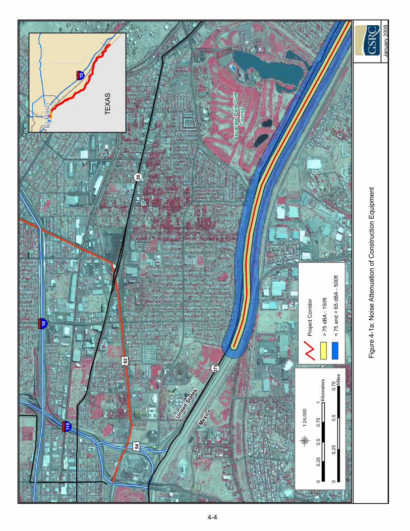
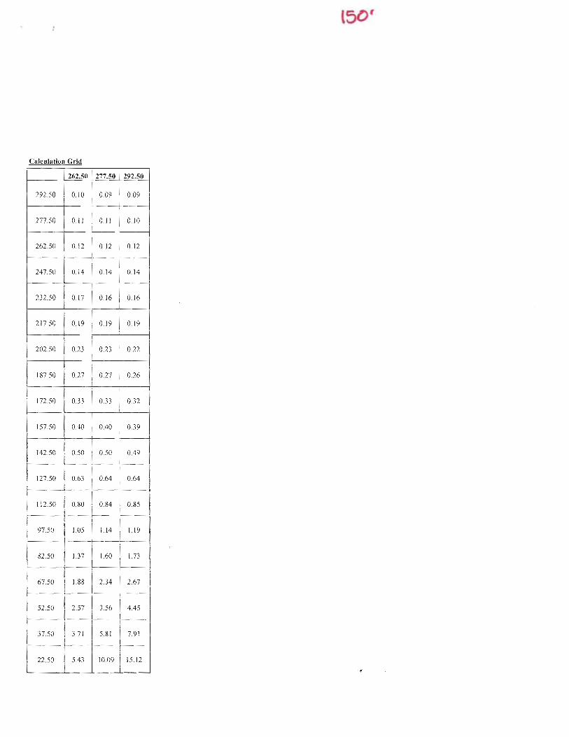
The project corridor stretches approximately 56.7 miles along the border. At the western end of the project corridor, primary pedestrian fence will be installed to replace existing chain link fence. Lights are already installed in this portion of the project corridor. This portion of the project corridor also parallels the Border Highway, a four-lane divided highway directly adjacent to the irrigation canal, which separates the fence construction area from residential neighborhoods. While the houses in these neighborhoods are located approximately 270 feet from the fence construction zone (see Figures 4-1a, 4-1b, and 4-1c), construction noise from fence construction is not expected to exceed the current ambient highway noise generated by traffic on the Border Highway. Therefore, there will be no substantial impacts on these receptors from the Planned Action construction.
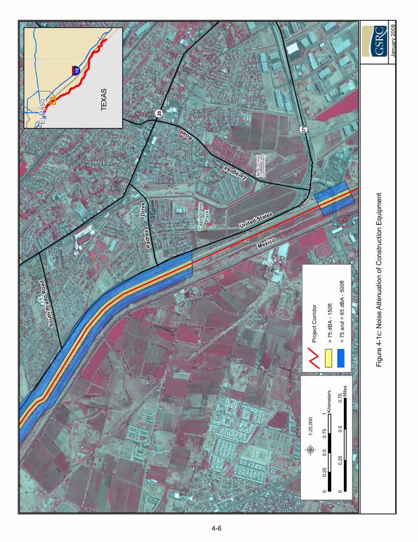
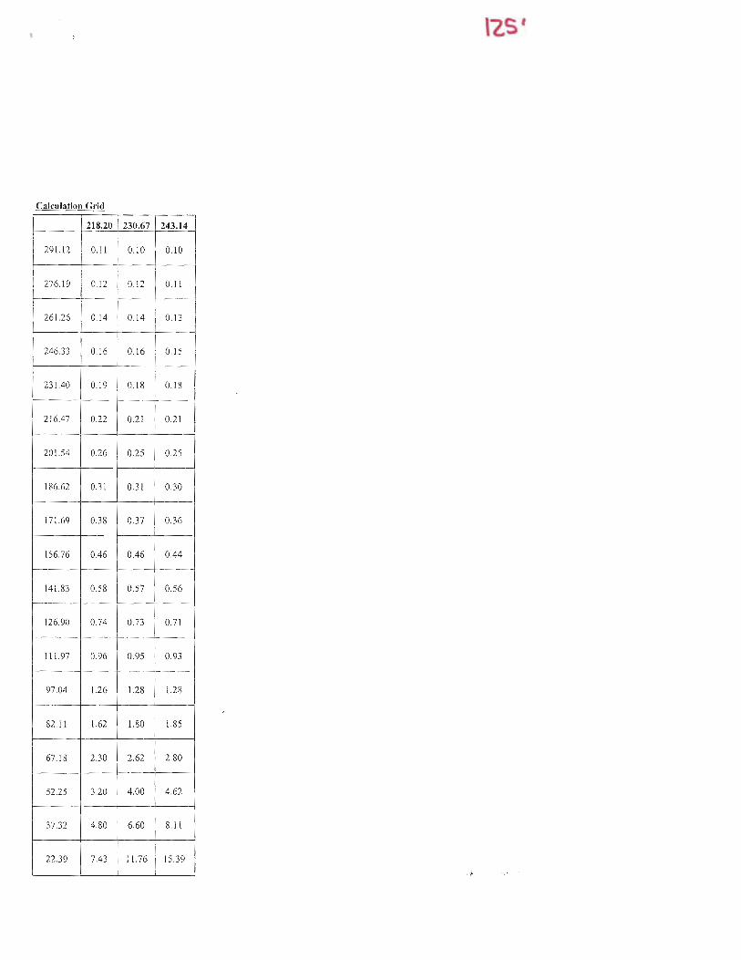
About 75 percent of the area is rural or industrial with no sensitive noise receptors. In San Elizario, the project corridor passes within 230 feet of three residential neighborhoods for a total of 2 miles (Figure 4-1d and 4-1e) where there is currently no fence or lights installed. The projection of the noise emissions from construction equipment to the three neighborhoods in San Elizario was determined using equations described previously. Table 4.1 describes noise emission levels for construction equipment which range from 70 dBA to 85 dBA (Federal Highway Administration [FHWA] 2007).
El Paso Sector Tactical Infrastructure
El Paso ESP July 2008 4-3
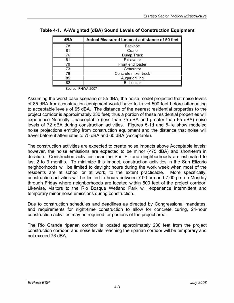
Table 4-1. A-Weighted (dBA) Sound Levels of Construction Equipment
dBA Actual Measured Lmax at a distance of 50 feet 78 Backhoe 81 Crane 76 Dump Truck 81 Excavator 79 Front end loader 73 Generator 79 Concrete mixer truck 85 Auger drill rig 82 Bull dozer Source: FHWA 2007
Assuming the worst case scenario of 85 dBA, the noise model projected that noise levels of 85 dBA from construction equipment would have to travel 500 feet before attenuating to acceptable levels of 65 dBA. The distance of the nearest residential properties to the project corridor is approximately 230 feet; thus a portion of these residential properties will experience Normally Unacceptable (less than 75 dBA and greater than 65 dBA) noise levels of 72 dBA during construction activities. Figures 5-1d and 5-1e show modeled noise projections emitting from construction equipment and the distance that noise will travel before it attenuates to 75 dBA and 65 dBA (Acceptable).
The construction activities are expected to create noise impacts above Acceptable levels; however, the noise emissions are expected to be minor (<75 dBA) and short-term in duration. Construction activities near the San Elizario neighborhoods are estimated to last 2 to 3 months. To minimize this impact, construction activities in the San Elizario neighborhoods will be limited to daylight hours during the work week when most of the residents are at school or at work, to the extent practicable. More specifically, construction activities will be limited to hours between 7:00 am and 7:00 pm on Monday through Friday where neighborhoods are located within 500 feet of the project corridor. Likewise, visitors to the Rio Bosque Wetland Park will experience intermittent and temporary minor noise emissions during construction.
Due to construction schedules and deadlines as directed by Congressional mandates, and requirements for night-time construction to allow for concrete curing, 24-hour construction activities may be required for portions of the project area.
The Rio Grande riparian corridor is located approximately 230 feet from the project construction corridor, and noise levels reaching the riparian corridor will be temporary and not exceed 73 dBA.
Figu
re4-
1a:N
oise
Atte
nuat
ion
ofC
onst
ruct
ion
Equi
pmen
t
Janu
ary
2008
ElP
aso
§̈ ¦10
00.
250.
50.
75 Mile
s
00.
250.
50.
751 Ki
lom
eter
s
1:24
,000
μ
TEX
AS
>75
dBA
-150
ft
<75
and
>65
dBA
-500
ft
Proj
ectC
orrid
or
§̈ ¦10
§̈ ¦110
£ ¤62
¬ «20
¬ «375
£ ¤54
Mex
ico
Unite
dSt
ates
Asc
arat
ePa
rkG
olf
Cou
rse
4-4
Figu
re4-
1b: N
oise
Atte
nuat
ion
of C
onst
ruct
ion
Equi
pmen
t
Janu
ary
2008
ElPa
so
§̈ ¦10
00.
250.
50.
75 Mile
s
00.
250.
50.
751 Ki
lom
eter
s
1:24
,000
μ
TEXA
S
>75
dBA
-150
ft
<75
and
>65
dBA
-500
ft
Proj
ectC
orrid
or
¬ «20
¬ «375
Lake
side
Yarb
roug
h
Driv
e
Thom
asM
anor
Park
Mid
way
Driv
e
San
Jose
JPSh
awve
rPa
rk
Mex
icoUn
ited
Stat
es
4-5
Janu
ary
2008
00.
250.
50.
75 Mile
s
00.
250.
50.
751 Ki
lom
eter
s
1:25
,000
μ>
75dB
A-1
50ft
<75
and
>65
dBA
-500
ft
Proj
ectC
orrid
or
Figu
re4-
1c: N
oise
Atte
nuat
ion
of C
onst
ruct
ion
Equi
pmen
t
¬ «20
¬ «375
Padr
esD
rive
Sout
hPr
ado
Roa
dEl
Paso
§̈ ¦10
TEXA
S
Zaragosa
Road
Cap
istr
ano
Park
Mt.
Car
mel
Cem
emta
ry
Mexico
United States
4-6
Janu
ary
2008
Figu
re4-
1d:N
oise
Atte
nuat
ion
ofC
onst
ruct
ion
Equi
pmen
t
>75
dBA
-150
ft
<75
and
>65
dBA
-500
ft
Proj
ectC
orrid
or
00.
250.
50.
75 Mile
s
00.
250.
50.
751 Ki
lom
eter
s
1:24
,000
μ
Wal
cott
Road
SocorroDrive
Socorro-San Elizario
Road
Vine
yard
Road Pa
ssm
ore
Road
United States
Mexico
ElP
aso
§̈ ¦10
TEX
AS
Sauz
al
4-7
Janu
ary
2008
ElPa
so
§̈ ¦10
00.
250.
50.
75 Mile
s
00.
250.
50.
751 Ki
lom
eter
s
1:24
,000
μ
TEXA
S
>75
dBA
-150
ft
<75
and
>65
dBA
-500
ft
Proj
ectC
orrid
or
Figu
re 4
-1e:
Noi
se A
ttenu
atio
n of
Con
stru
ctio
n Eq
uipm
ent Sa
nEl
izar
io
SocorroRo
ad
Luis
a
Drive
Gue
rra
Perico Drive
Guitar
Driv
e
Las
Pam
pas
Road
Gloriet
taRoa
d
Alarcon
Road
Mexico
United States
4-8
SECTION 5.0LAND USE, RECREATION, AND AESTHETICS
El Paso Sector Tactical Infrastructure
El Paso ESP July 2008 5-1
5.0 LAND USE, RECREATION AND AESTHETICS
5.1 AFFECTED ENVIRONMENT
5.1.1 Land Use The entire project corridor is owned and maintained by USIBWC, EPCWID1 and HCCRD1. It is maintained for flood control and irrigation water diversion, and the general public does not generally access the area, except in the adjacent Rio Bosque Wetland Park. The adjacent areas on the U.S. side of the EPCWID1 and HCCRD1 canals range from developed residential and commercial/industrial property in the City of El Paso to tilled and irrigated agricultural land south and east of the city in El Paso County. In Hudspeth County, the adjacent areas on the U.S. side of the levee and canal are tilled and irrigated agricultural land.
5.1.2 Aesthetic and Visual Resources The project area contains a man-made canal and levee system that has altered the natural topography. The cities of El Paso and Juarez are located north and southwest of the project area in the U.S. and Mexico, respectively. Properties adjacent to the levee system are primarily developed, consisting of industrial, agricultural, commercial and residential development. USBP shelters located approximately every mile and the USBP lights are the only structures between the levee and the Rio Grande. The levee and portions of the floodplain are cleared and mowed regularly to maintain flood control features, and the levee is topped by a dirt and gravel road. The only natural landscapes in the area are the Rio Bosque Wetland Park, which is a wetland mitigation area that is being restored with native flora, and the Alamo Arroyo and Diablo Arroyo drains, located approximately 4 miles northwest of the Fort Hancock POE and at the east end of the project corridor, respectively.
The view of the Rio Grande and the floodplain is obscured by the presence of the USIBWC levee, and access to the levee is restricted, so that views of the Rio Grande are not readily available to the general public.
5.2 ENVIRONMENTAL EFFECTS
5.2.1 Land Use The Planned Action will occur within the property owned and managed by USIBWC, EPCWID1 and HCCRD1, and currently used for USBP enforcement activities; therefore, the future project area use is compatible with the existing land use, and no direct effect on land use in the region will occur. Indirect beneficial effects will occur due to reduced illegal traffic from crossing IAs and resulting damage to adjacent agricultural fields.
5.2.2 Aesthetics and Visual Resources The USIBWC levee already interrupts the view of the Rio Grande from the U.S. side of the border. The addition of a fence along the levee toe will not detract appreciably from
El Paso Sector Tactical Infrastructure
El Paso ESP July 2008 5-2
this current view. Access for the Ysleta de Sur Pueblo to the Rio Grande floodplain south of the levee will be provided through gates at specified locations.
The installation of permanent lights along the flood side of the levee will have an impact on the nighttime appearance of the area due to the illumination of the south side of the levee and the area between the levee and the river. The lights will be directed to illuminate only the ground area beneath and to the south of the light standards, and will be shielded to prevent light trespass north of the levee into areas currently inhabited by U.S. citizens. Roads and developed areas already border the north side of the EPCWID1 and HCCRD1 canals, and, where residential development is absent, rural farm land is the predominant land use. Therefore, the addition of lights in this area will have minimal effect on the aesthetics of the area on the U.S. side of the canal. The lights will be visible from Mexico, but the illuminated area will not reach the Rio Grande. Design criteria and illumination diagrams for the lights can be found in Appendix C. Portable lights used during construction will result in temporary nighttime visual impacts.
The bridges will be constructed in the same footprint as previous bridges across the EPCWID1 and HCCRD1 canals and at logical canal crossing points at the ends of established roads and, therefore, will not detract from the appearance of the area.
A proposed pedestrian walkway along the Rio Grande through El Paso and connecting to the Rio Bosque Park could not be constructed after the Planned Action is implemented unless access through the fence is secured, since the fence would prevent any pedestrian connection between the river and the area north of the USIBWC levee. Since the existing portions of this trail system are located north of the border fence in the City of El Paso, this restriction should not be an impediment to extending the trail system. A possible proposed foot trail along the Rio Grande could still be constructed, since the fence will not obstruct any activities in the floodplain. CBP will coordinate with the city and the county to attempt to avoid conflicts between the future expansion of the existing trail and the fence. Few visitors visit the Rio Bosque Wetland Park at night, so there will be no substantial impacts on appearance from lights along the levee; however, the light poles and the fence will be visible during the day.
SECTION 6.0WATER USE AND QUALITY
El Paso Sector Tactical Infrastructure
El Paso ESP July 2008 6-1
6.0 WATER USE AND QUALITY
6.1 AFFECTED ENVIRONMENT
6.1.1 Hydrology and Groundwater Subsurface water resources within the project area are found in the Hueco Basin, which is recharged by storm water, and in the Rio Grande aquifer system. The latter is recharged by stream flow originating as precipitation in the mountains of Colorado and northern New Mexico, as well as by irrigation-return recharge. The primary loss of subsurface water resources in the project area is through wells which extract groundwater for municipal and irrigation uses.
The average daily water demand for the City of El Paso was 97 million gallons per day in 2006 (El Paso Water Utilities 2007), and annual water use in El Paso County and Hudspeth County was 11.1 billion gallons and 5.5 billion gallons, respectively, in 2004 (Texas Water Development Board 2007). Available water supply for El Paso County in 2005 was 49 billion gallons, and for the lower portion of Hudspeth County it was approximately 200 billion gallons. Neither county is experiencing water shortages due to excess demand over water supply.
6.1.2 Surface Waters and Waters of the U.S. Surface water resources in the area consist of the Rio Grande and various canals which divert the river water flow for irrigation and flood control purposes. The Rio Grande is located adjacent to, but not within, the project corridor. The EPCWID1 and HCCRD1 canals are located directly adjacent to the project area, and will be crossed by the eight bridges. No WUS are located within the project corridor.
The only wetlands in the vicinity of the project area are found in the Rio Grande, the Rio Bosque Wetland Park, the Alamo Arroyo near Fort Hancock and the Diablo Arroyo at the east end of the project corridor. None of these wetland areas are located within the Planned Action construction footprint; however, the Rio Bosque Wetland Park, the Alamo Arroyo and the Diablo Arroyo are located adjacent to the project corridor.
6.1.3 Floodplains The current floodplain of the Rio Grande on the U.S. side of the river is defined by the Rio Grande and the USIBWC flood control levee. The floodplain is characterized by relatively flat ground, vegetated by various bunch-type grasses and invasive species which are routinely mowed by USIBWC for flood control, and to improve visibility for USBP operations. The only natural vegetation remaining in the floodplain is a narrow strip of riparian vegetation immediately adjacent to the Rio Grande. A dirt road runs along the unprotected side of the levee within the floodplain.
El Paso Sector Tactical Infrastructure
El Paso ESP July 2008 6-2
6.2 ENVIRONMENTAL EFFECTS
Although the Secretary’s waiver means that CBP no longer has any specific legal obligations under the Clean Water Act (CWA) for the TI segments addressed in this ESP, the Secretary committed the Department to responsible environmental stewardship of our valuable natural and cultural resources. CBP supports this objective and has applied the appropriate standards and guidelines associated with the CWA as the basis for evaluating potential environmental impacts and appropriate mitigations.
6.2.1 Hydrology and Groundwater Local subsurface water resources will be utilized for dust control and all-weather surfacing of roads in the project area, and water will be obtained from existing suppliers. Water will also be used for mixing and preparing concrete used to construct the fence footings and to install the lights. It is estimated that approximately 12 to 14 million gallons of water will be used over the 56.7-mile length of the Planned Action during the course of construction. Because the water used for the Planned Action is considered to be minor when compared to the very large average water use and availability of the City of El Paso and El Paso and Hudspeth counties, and the increased water use will be temporary during the construction period, a negligible impact on water resources will result from the Planned Action.
6.2.2 Surface Waters and Waters of the U.S. The Planned Action is not expected to directly impact surface water resources, and no activities will take place in WUS, including wetlands. No construction is planned within Alamo Arroyo or Diablo Arroyo that would involve fill below the ordinary high water mark of these drainages. A Storm Water Pollution Prevention Plan (SWPPP) will be prepared prior to construction, and BMPs will be implemented in order to minimize impacts on surface water resources, such as irrigation canals, resulting from erosion during construction or fluids spills/leaks from construction equipment. Therefore, impacts on surface water resources will be minimal.
6.2.3 Floodplains The Planned Action will install light poles within the Rio Grande floodplain at the base of the USIBWC levee. The poles will not impede flood water flow within the floodplain, and will not impact the integrity of the levee, so floodplain impacts will be minimal. Some equipment or material staging could occur within the Rio Grande floodplain as well, but this will be temporary, and no equipment or materials will be left during high water events. All other activities (installation of fence and bridges) will occur outside of the floodplain.
SECTION 7.0BIOLOGICAL RESOURCES
El Paso Sector Tactical Infrastructure
El Paso ESP July 2008 7-1
Photograph 7-1. Rio Bosque view from the USIBWC levee
7.0 BIOLOGICAL RESOURCES
7.1 AFFECTED ENVIRONMENT
7.1.1 Vegetative Habitat A general vegetation species survey conducted by the U.S. Army Corps of Engineers (USACE) on a portion of the project corridor was completed on February 4, 2003. Vegetation observed consisted mainly of bunch-type grasses, Russian thistle (Salsola kali), saltcedar (Tamarix ramisissima), dandelion (Taraxacum spp.), and cottonwood (Populus spp.). Various willows (Salix spp.) were located within the floodplain of the Rio Grande adjacent to the river.
A second vegetation species survey was conducted on January 17, 2007. In addition to those species identified above, vegetation observed included the following: tree cholla (Opuntia imbricata), four-winged saltbush (Atriplex canescens), mesquite (Prosopsissp.), cattail (Typha sp.) and prickly pear (Opuntia spp.).
The levee system grasses are mowed regularly to provide for suitable design flood features and slope protection, and to provide clearance for maintenance equipment and USBP vehicles. The banks and bed of the EPCWID1 and HCCRD1 canals are regularly maintained by dredging to remove excess sediment and debris, and to clear bank vegetation to improve flow characteristics. Vegetation between the canal and the river has been either cut and removed, or is routinely mowed by USIBWC for flood control purposes. Only a very narrow riparian corridor (approximately 0-8 feet wide) remains along the top banks of the Rio Grande.
The Rio Bosque Wetland Park is a wetland restoration project constructed in 1997, and managed by the University of Texas at El Paso (UTEP) (Photograph 7-1). The bosque area was restored, and wetland hydrology was introduced through a series of channels and basins connected to the adjacent irrigation canals. The park now supports a wide variety of native wetland and riverside flora (UTEP-Center for Environmental Resource Management [CERM] 2007).
El Paso Sector Tactical Infrastructure
El Paso ESP July 2008 7-2
7.1.2 Wildlife and Aquatic Resources A general animal species survey was conducted by USACE on February 4, 2003. Animal species observed during the survey consisted of: redtail hawk (Buteo jamaicensis), American kestrel (Falco sparverius), great blue heron (Ardea herodias),cattle egret (Bubulcus ibis), muskrat (Ondantra zibethicus), peregrine falcon (Falcoperegrinus), common black hawk (Buteogallus anthracinus), greater roadrunner (Geococcyx californianus), northern goshhawk (Accipiter gentiles), mallard (Anas platyrhynchos), black-tailed jackrabbit (Lepus californicus), blue-winged teal (Anas discors), mule deer (Odocoileus hemionus) tracks, and fox (Vulpes spp. or Urocyoncinereoargenteus) tracks. A group of wading birds and raptors (no owls) of varying color phases and sizes were observed, but positive identifications of these were not made.
In the January 17, 2007 survey conducted by Gulf South Research Corporation (GSRC), species observed included mallard, Swainson’s hawk (Buteo swansoni), killdeer (Charadrius vociferus), northern harrier (Circus cyaneus), wood duck (Aix sponsa), Chihuahuan raven (Corvus cryptoleucus), loggerhead shrike (Lanius ludoviscianus), American kestrel, great-tailed grackle (Quiscalus mexicanus), cattle egret, mourning dove (Zenaida macroura), great blue heron and common moorhen (Gallinule chloropus). Within the only heavily vegetated staging area for the project in Tornillo (see Figure 2-4j), a June 9, 2008 survey observed mockingbird (Mimus polyglottos), western kingbird (Tyrannus verticalis), ruby-throat hummingbird (Lampornis clemenciae) and mourning dove, as well as a black-tailed jackrabbit. The survey did not reveal any active migratory bird nests within the vegetation, which was dominated by salt cedar.
Burrowing owls (Athene cunicularia) have been observed by USBP agents and during surveys of the levee by USIBWC personnel (USIBWC 2007). This species may use existing burrows in the levee flanks year around. The burrows might also be used for nesting.
Within the Rio Bosque Wetland Park, over 216 species of birds utilize the park wetland areas, including 39 species of conservation concern (UTEP-CERM 2007).
There are no aquatic resources within the project corridor. The water in the irrigation canals is pumped from the river and screened. In addition, the canals are sometimes dry during droughts and non-irrigation seasons, and thus would not support a viable aquatic faunal population.
7.1.3 Threatened and Endangered Species There are five Federally endangered (E) and threatened (T) species known to occur in the El Paso area, and two of those species, the northern aplomado falcon (Falcofemoralis septentrionalis) and southwestern willow flycatcher (Empidonax traillii extimus), also occur in Hudspeth County. A list of these species is presented in Table 7-1.
El Paso Sector Tactical Infrastructure
El Paso ESP July 2008 7-3
Table 7-1. Federally Listed Species for El Paso County, Texas
Common Name Scientific Name Federal Status PlantsSneed’s pincushion cactus Coryphantha sneedii var. sneedii EBirdsNorthern aplomado falcon** Falco femoralis septentrionalis EInterior least tern Sterna antillarum ESouthwestern willow flycatcher** Empidonax traillii extimus EMexican spotted owl** Strix occidentalis lucida T
** Also listed for Hudspeth County, Texas
The Sneed‘s pincushion cactus (Coryphantha sneedii var. sneedii) grows on limestone ledges at elevations between 3,900 to 7,000 feet above mean sea level. The northern aplomado falcon prefers open grasslands terrain with relatively low ground cover and scattered shrubs and yucca for nesting. Neither of these habitats occurs in the area of the project corridor. The interior least tern (Sterna antillarum), although preferring nearly bare ground for nesting, has had its habitat severely disturbed by channelization projects and constant traffic associated with urban areas. Suitable habitat may occur for the interior least tern and the southwestern willow flycatcher intermittently along the Rio Grande adjacent to the project corridor. No preferred habitat exists within or adjacent to the project limits for the Mexican spotted owl (Strix occidentalis lucida),which prefers remote, shaded canyons of coniferous mountain woodlands (pine and fir). Several state-listed species also occur near the project corridor in El Paso and Hudspeth counties. Many of the species listed as endangered or threatened by TPWD for El Paso and Hudspeth counties would not occur in the study area. There are two endangered state-listed species that possibly occur in the project area; the interior least tern and the southwestern willow flycatcher, and their habitat and occurrence were described above. In addition, the Texas horned lizard (Phrynosoma cornutum), listed as threatened, may occur in the project corridor. The Big Bend slider (Trachemys gaigeae) and the western burrowing owl may occur in the project corridor, and are listed as rare, but with no regulatory listing status (TPWD 2006).
7.2 ENVIRONMENTAL EFFECTS
Although the Secretary’s waiver means that CBP no longer has any specific legal obligations under the Endangered Species Act (ESA) for the TI segments addressed in this ESP, the Secretary committed the Department to responsible environmental stewardship of our valuable natural and cultural resources. CBP supports this objective and has applied the appropriate standards and guidelines associated with the ESA as the basis for evaluating potential environmental impacts and appropriate mitigations.
7.2.1 Vegetative Habitat Because the project corridor has already been disturbed from levee and canal construction, impacts on native vegetation will be negligible. Construction activities that would disturb vegetation will be kept to a minimum, and existing vegetation will be left in
El Paso Sector Tactical Infrastructure
El Paso ESP July 2008 7-4
place wherever possible. Temporarily disturbed areas along the construction access roads in the Rio Grande floodplain and in the temporary staging areas will be allowed to revegetate naturally, and no herbicides use is expected during construction. No activities will take place within the Rio Bosque Wetland Park, the Alamo Arroyo or the Diablo Arroyo.
7.2.2 Wildlife and Aquatic Resources Direct impacts on wildlife resulting from the operation of the high intensity lighting at night could potentially occur. Approximately 21 additional miles of the floodplain along the Rio Grande will be illuminated under in this Planned Action. The increase in lights along the border could also produce some long-term behavioral effects, although the magnitude of these effects in some areas is not presently known. Artificial lighting can disrupt terrestrial animal dispersal movement or increase the risk of a small animal being killed by a predator; however, many animals would simply choose to move away from the lights (Beier 2006).
The use of high pressure sodium vapor lamps does not attract insects to the extent of mercury vapor lamps. These lamps will still attract bats to forage, but the light–attracted insects would be impacted to a lesser extent (Rydell 2006). Artificial lighting may influence species movements or impact migration corridors; however, for species that are susceptible to light attraction or disorientation, shielding will reduce these impacts (Longcore and Rich 2006).
An illumination study was prepared by EPE detailing the contours for illumination levels of the lights. The results of this study can be found in Appendix C. The lights will be spaced 125 to 150 feet apart, and are back shielded so that the illumination is directed forward and downward away from the levee. Furthermore, the design of the lighting is such that it will only illuminate 175 feet in front of the lights. The Rio Grande is approximately 230 feet from the lighting source, leaving approximately 50 feet of the Rio Grande floodplain closest to the river illuminated only by natural light. The lighting system is also designed in such a way that the lights will not illuminate the top of the levee or behind it; therefore, there will be no substantial impacts on wildlife north of the levee or beyond 175 feet south of the lights.
The portable lights used during construction and other noise and construction activities may temporarily disturb wildlife on adjacent properties; the levees and existing agricultural fields within and adjacent to the project area provide suitable habitat for burrowing owls. If construction activities begin between March 1 and September 1, a field survey will be conducted by a qualified biologist to identify migratory bird nests, and in particular, active burrowing owl nests. Mitigation measures identified in Section 1.5 will be implemented and the birds will be relocated to habitat outside of the project area, thus, avoiding a major impact on the owls.
Species that could be affected by construction noise could include passerine birds, such as song sparrow (Melospiza melodia), black-throated sparrow (Amphispiza bilineata) or western kingbird (Tyrannus veticalis); and small mammals such as kangaroo rats
El Paso Sector Tactical Infrastructure
El Paso ESP July 2008 7-5
(Dipodomys spp.), ground squirrels (Spermophilus spp.) or striped skunk (Mephitismephitis). Since the highest period of movement for most wildlife species occurs during night time or low daylight hours (MacMahon 1992), and construction activities will be conducted during daylight hours to the maximum extent practicable, temporary noise impacts on wildlife species are expected to be minor.
Noise generated during construction will impact wildlife resources in the Rio Bosque Wetland Park; however, attenuation of noise levels prior to reaching the Rio Grande riparian corridor will reduce impacts on wildlife in the riparian corridor to a minimal level, and the impacts will be temporary.
The presence of a continuous canal north of the USIBWC levee, in addition to the Rio Grande, constitutes an existing impediment to the migration of terrestrial wildlife north from Mexico. Furthermore, the heavily developed and populated areas south of the Rio Grande in Mexico also discourage wildlife migration from north to south in the project area. A 4-inch gap will be incorporated into the base of the fence to allow small mammals, reptiles and amphibians to migrate between the Rio Grande floodplain and the canals and agricultural fields north of the levee. The bollard-style fence will also allow transboundary migration of smaller animals. Therefore, the addition of a fence south of the canal will not substantially increase impediments to north-south migration of terrestrial wildlife in the area.
7.2.3 Threatened and Endangered Species No Federally threatened or endangered species were observed within the project area during the biological surveys performed in 2003 and 2007. Also, no designated critical habitat for any Federal listed species occurs within the project corridor. Since the artificial lighting will not reach the Rio Grande riparian corridor, there will be no lighting effect on the southwest willow flycatcher or the interior least tern.
Noise generated during construction of the lights will temporarily increase in the area north of the Rio Grande riparian corridor; however, the amount of noise reaching the river will be between 65 and 75 dBA (A-weighted decibel, see Section 4.2) and will occur on an intermittent basis. Thus, negligible impacts will occur on wildlife species that might be present in the riparian corridor. Construction of the fence will occur on the north side of the USIBWC levee, and the levee will help to shield the Rio Grande riparian corridor from excess noise during construction.
Open fence and post holes and trenches during construction will be checked each day for Texas horned lizards and other small wildlife, and wildlife species found will be removed. Mitigation measures described in Section 7.2.2 above will be implemented to avoid impacts on burrowing owls.
El Paso Sector Tactical Infrastructure
El Paso ESP July 2008 7-6
THIS PAGE LEFT INTENTIONALLY BLANK
SECTION 8.0CULTURAL, HISTORICAL, AND ARCHAEOLOGICAL RESOURCES
El Paso Sector Tactical Infrastructure
El Paso ESP July 2008 8-1
8.0 CULTURAL, HISTORICAL, AND ARCHAEOLOGICAL RESOURCES
8.1 AFFECTED ENVIRONMENT
Preliminary investigations of the files at the Texas Archaeological Research Laboratory indicated that portions of the Planned Action cross the features of the EPCWID1 Historic District and sites 41EP4678 and 41EP4679, the Riverside Intercepting Drain and Riverside Canal, respectively. The EPCWID1 Historic District has been listed on the National Register of Historic Places (NRHP) under criteria A and C. Both 41EP4678 and 41EP4679 are recommended potentially eligible under criterion A.
Given that the area of the planned infrastructure has been previously and deeply disturbed by the construction of the USIBWC levee and the EPCWID1 and HCCRD1 irrigation canals, there is a low probability for intact prehistoric cultural deposits in the project area.
The Ysleta del Sur Pueblo requested an unlighted landscape near the Rio Grande for tribal ceremonies. A MOA between USBP and the Tribe signed in 2005 prescribes switches on banks of the lights near their ceremonial areas so that the lights can be turned off when necessary.
8.2 ENVIRONMENTAL EFFECTS
Although the Secretary’s waiver means that CBP no longer has any specific legal obligations under the National Historic Preservation Act (NHPA) for the TI segments addressed in this ESP, the Secretary committed the Department to responsible environmental stewardship of our valuable natural and cultural resources. CBP supports this objective and has applied the appropriate standards and guidelines associated with the NHPA as the basis for evaluating potential environmental impacts and appropriate mitigations.
The Planned Action will result in ground disturbance during excavation of the toe of the levee to accept placement of the fence foundations, use of temporary staging areas during construction, and excavation within the project area to install light poles; however, all of the ground surface within the project area has already been disturbed by construction of the USIBWC levee, the EPCWID1 and HCCRD1 canals and numerous dirt roads. The likelihood for discovery of any intact prehistoric cultural material is very remote.
Archaeological monitoring during the installation of all light poles and fence foundations within the project corridor will be conducted to identify any deeply buried archaeological deposits that might be impacted during the installation of the lights and fence. Should any deeply buried resources be discovered, work will cease in the area of the discovery until an archaeologist can determine the significance of the resource, coordination with SHPO is conducted, and a mitigation plan prepared, if necessary.
El Paso Sector Tactical Infrastructure
El Paso ESP July 2008 8-2
It is not anticipated that the planned infrastructure installation will impact the integrity of the EPCWID1 Historic District. Replacement of the bridges over the irrigation systems will occur in areas where pre-existing bridges have deteriorated or been removed, and that are noted as ancillary structures in the EPCWID1 Historic District form. Other bridge placement locations are at the ends of existing roads where canal crossovers would be logically placed. SHPO will be allowed to review the bridge designs to be sure that they do not diminish the integrity of the Historic District.
Given that the area of the planned infrastructure has been previously disturbed in the past by the construction of the USIBWC levee and EPCWID1 and HCCRD1 canals, there is a low probability for intact buried cultural deposits. All staging areas north of the levee have been surveyed and no historic properties were discovered that could be considered to be potentially eligible for listing on the NRHP. Furthermore, an archaeological monitor will be present during the installation of all lights and fence foundations. Therefore, no adverse impacts on historic properties are anticipated from implementation of the Planned Action.
In order to prevent interference with Ysleta del Sur Pueblo ceremonial activities along the river, sections of the lights will be equipped with switches to allow them to be turned off when necessary, as specified in the MOA between CBP and the Tribe.
SECTION 9.0SOCIOECONOMICS
El Paso Sector Tactical Infrastructure
El Paso ESP July 2008 9-1
9.0 SOCIOECONOMICS
9.1 AFFECTED ENVIRONMENT
9.1.1 Socioeconomics The socioeconomic environment for the project region was described in detail in the USBP Programmatic EA (USBP 2006). In summary, the USBP Programmatic EA examined population structure, housing, environmental justice and protection of children. Only those portions of the socioeconomic environment that have changed since the USBP Programmatic EA are discussed in this ESP. Table 9-1 illustrates the difference in socioeconomic data for those indices which have changed between the current ESP and the USBP Programmatic EA in 2006. The region of influence (ROI) examined is El Paso County and Hudspeth County, Texas.
Table 9-1. Socioeconomic Data for El Paso and Hudspeth Counties
El Paso County Hudspeth County IndexUSBP 2006 Data Current Data USBP 2006 Data Current Data
Total population 702,609 (2000) 736,310 (2006) 3,257 (2000) 3,344 (2006) Total number of jobs 240,723 (2000) 349,204 (2005) 1,228 (2000) 1,551 (2005) Percent annual unemployment rate 5.2 (2000) 6.7 (2006) 4.3 (2000) 7.4 (2006)
Total personal income $14.7B (2003) $16.8B (2005) $53.7M (2003) $48.9M (2005) Per capita personal income, in thousands $20,875 (2003) $23,256 (2005) $16,482 (2003) $14,804 (2005)
Percentage of all ages in poverty 23.8 (2000) 24.6 (2004) 35.8 (2000) 26.6 (2004)
Source: Bureau of Economic Analysis (BEA) 2005 a, b, c, and d, Census Bureau 2004, USBP 2006, Texas County Information Project 2006 a and b.
B= billion, M=million
In 2005, El Paso County had a per capita personal income (PCPI) of $23,256 (BEA 2005c). This PCPI ranked 184th in the State of Texas, and was 72 percent of the state average of $32,460, and 67 percent of the National average of $34,471. The average annual growth rate of PCPI from 1995 to 2005 was 4.6 percent. This average annual growth rate was higher than the growth rate for the state (4.4 percent) and higher than that for the Nation (4.1 percent). In 2005, El Paso County had a total personal income (TPI) of $16.8 billion. This TPI ranked 9th in the state and accounted for 2.3 percent of the state total. The 2005 TPI reflected an increase of 6.6 percent from 2004, which was lower than the 2004-2005 state change of 7.8 percent and the national change of 5.2 percent. In El Paso County during 2004, 24.6 percent of the population was living below the poverty level, which is higher than the 16.2 percent of the state population in poverty (U.S. Census Bureau 2004).
In 2005, Hudspeth County had a PCPI of $14,804 (BEA 2005d). This PCPI ranked 249th
in the State of Texas, and was 46 percent of the state average of $32,460, and 43
El Paso Sector Tactical Infrastructure
El Paso ESP July 2008 9-2
percent of the national average of $34,471. The average annual growth rate of PCPI from 1995 to 2005 was 3.7 percent. This average annual growth rate was lower than the growth rate for the state (4.4 percent) and lower than that for the Nation (4.1 percent). In 2005, Hudspeth County had a TPI of $48.9 million, which ranked 234th in the state. The 2005 TPI reflected a decrease of 7.1 percent from 2004, which was lower than the 2004-2005 state increase of 7.8 percent and the National increase of 5.2 percent. In Hudspeth County during 2004, 26.6 percent of the population was living below the poverty level, which is higher than the 16.2 percent of the state population in poverty (U.S. Census Bureau 2004).
9.1.2 Environmental Justice Minority and poverty status in the vicinity of the Planned Action was examined to determine if any minority and/or low-income communities would potentially be disproportionately affected by implementation of the Planned Action. Both low-income and minority populations are present within the ROI, and up to 70 percent of the population of El Paso claims Hispanic origins.
9.1.3 Protection of Children Children, still undergoing physiological growth and development, are more sensitive to adverse environmental health and safety risks than adults. Special risks to children related to construction activity may include safety, noise, pollutants, and hazardous materials. Children would be more likely to be present in residential neighborhoods adjacent to the project corridor rather than in the less populated agricultural areas.
9.1.4 Human Health and Safety Currently, the safety of USBP agents in the area of the Planned Action is compromised by a lack of visibility at night along the canal and levee, and the inability to readily access portions of the patrol area between the canal and the Rio Grande.
The health and safety of IAs attempting to illegally cross the river and the EPCWID1 and HCCRD1 canals are at risk, especially during periods of high water. Emergency rescue attempts are hindered by a lack of bridge access to the area between the canal and the river and the lack of visibility at night. The safety of residents and property in the U.S. along the project corridor during floods is also diminished due to lack of access for USIBWC, EPCWID1 and HCCRD1 maintenance and flood fighting personnel.
9.2 ENVIRONMENTAL EFFECTS
Although the Secretary’s waiver means that CBP no longer has any specific legal obligations under Executive Order (EO) 12898 and EOI 13045 for the TI segments addressed in this ESP, the Secretary committed the Department to responsible environmental stewardship of our valuable natural and cultural resources. CBP supports this objective and has applied the appropriate standards and guidelines associated with the EOs as the basis for evaluating potential environmental impacts and appropriate mitigations.
El Paso Sector Tactical Infrastructure
El Paso ESP July 2008 9-3
9.2.1 Socioeconomics The Planned Action would utilize USBP staff, JTF-N or National Guard units, or private contractors to construct the permanent lights, fence and bridges; therefore, there will be no effects on population, personal income, or housing unless private contractors were used. In this event, a temporary increase in personal income may occur. Most materials and other project expenditures will be obtained from within the local community, providing minor temporary, direct economic benefits. Adequate housing is available in the El Paso area, and no displacement is predicted to result from this Planned Action; therefore, there will be no direct impacts on housing in the region. The planned fence and lights along the USIBWC levee should not impact recreational activities south of the levee, since access to the Rio Grande floodplain is already restricted by existing fences and gates, lack of bridges, as well as USBP patrols. No substantial, permanent or long-lasting socioeconomic impacts are anticipated as a result of the construction activity.
9.2.2 Environmental Justice No disproportionate environmental effects have been identified for any resource area or population (minority, low-income, or otherwise) analyzed in this ESP. Furthermore, there will be no displacements of residences or businesses.
Elimination of illegal cross-border activities will benefit the entire population of El Paso and Hudspeth counties, regardless of age, nationality, ethnicity, or economic status. Thus, the Planned Action will not disproportionately affect minority or low income populations.
9.2.3 Protection of Children Safety precautions to prevent access of children to the work sites for the Planned Action will include adequate measures to restrict access, and minimize hazards associated with construction activities, and proper handling and disposal of hazardous materials. Such mitigation measures will serve to offset any potential for impacts on children. All of the construction activities, with the exception of bridge construction, will occur south of the EPCWID1 and HCCRD1 canals, where access is currently restricted. With the implementation of mitigation measures, no impacts or special risks for children will be associated with the Planned Action.
9.2.4 Human Health and Safety Impacts on human health and safety will be limited to those normally encountered during construction activities. An approved Health and Safety Plan will be developed by the project contractor prior to initiating construction activities to minimize those impacts. Construction site safety is largely a matter of adherence to regulatory requirements imposed for the benefit of employees and implementation of operational practices that reduce risks of illness, injury, death, and property damage. OSHA and EPA issue standards that specify the amount and type of training needed for industrial workers, the use of protective equipment and clothing, engineering controls, and maximum exposure limits with respect to workplace stressors.
El Paso Sector Tactical Infrastructure
El Paso ESP July 2008 9-4
Construction workers at any of the planned construction sites will be exposed to safety risks from the inherent dangers at construction sites. Contractors will be required to establish and maintain safety programs at the construction site. The planned construction will not expose members of the general public to increased safety risks.
Increased nighttime visibility of the border area and the added deterrent of border fencing will have long-term beneficial effects for USBP employees operating in the El Paso, Ysleta, Fabens and Fort Hancock AOs.
Medical services, fire protection and police service will not be changed from the current standards for the area. The Planned Action will not create any additional burden on any health and safety services. The safety of persons in distress in the area between the canal and the Rio Grande will be enhanced by the added access for emergency personnel afforded by the new bridges, and the increased visibility resulting from the lighting of the area.
The design and location of the primary pedestrian fence footings will not compromise the integrity of either the USIBWC levee or the EPCWID1 and HCCRD1 canals, and the flood protection and irrigation afforded by these structures will not be diminished.
SECTION 10.0UTILITIES AND INFRASTRUCTURE
El Paso Sector Tactical Infrastructure
El Paso ESP July 2008 10-1
10.0 UTILITIES AND INFRASTRUCTURE
10.1 AFFECTED ENVIRONMENT
Currently, electrical power for the project corridor is provided by EPE through its regional power grid. In the rural portions of the project corridor, electric power supply is available adjacent to the irrigation canals to support scattered rural farm homes and intermittent irrigation pumping equipment along the project corridor. EPE provides power to an approximately 10,000-square-mile area of Texas and New Mexico, and participates in balance area agreements with surrounding power companies, including those in Mexico, to provide additional power during peak user times. The 2006 peak daily demand for EPE was 1,376 megawatts (North American Electric Reliability Council 2006). EPE maintains a 16 percent margin of available power above firm peak demand (El Paso Regional Economic Development Corporation [REDCO] 2006).
10.2 ENVIRONMENTAL EFFECTS
Installation of permanent lights along 21 miles of the project corridor by EPE will involve additional installation of power grid feeds from the local network, and installation of power line support poles and transformers. Installation of this additional power infrastructure will result in minor impacts on soils and minor noise impacts where infrastructure is installed adjacent to residential neighborhoods. All of the soil disturbance will occur in existing disturbed ROWs, and the noise impacts will be no different than those resulting from normal power infrastructure maintenance operations; thus, the impacts will be minor.
The power necessary for operation of the permanent lights will be roughly equivalent to the amount used to power a small high school (approximately 7.7 million kilowatt hours annually). The substations that will be handling the additional lighting have ample capacity to serve the additional load (EPE 2008). This is not considered to be a substantial amount when compared to the overall electric power available in the local power grid and the 16 percent power reserve maintained by EPE. The lights will be installed and maintained by EPE as part of their overall public light maintenance program.
El Paso Sector Tactical Infrastructure
El Paso ESP July 2008 10-2
THIS PAGE LEFT INTENTIONALLY BLANK
SECTION 11.0HAZARDOUS MATERIALS
El Paso Sector Tactical Infrastructure
El Paso ESP July 2008 11-1
11.0 HAZARDOUS MATERIALS
11.1 AFFECTED ENVIRONMENT
As determined by a reconnaissance survey of the project corridor, there are no industrial or other commercial facilities near the project corridor that contain hazardous materials or hazardous waste. Construction equipment used to implement the Planned Action will contain fuel and petroleum fluids and lubricants that would be considered hazardous if released into the environment.
11.2 ENVIRONMENTAL EFFECTS
Although the Secretary’s waiver means that CBP no longer has any specific legal obligations under Comprehensive Environmental Response, Compensation, and Liability Act (CERCLA) for the TI segments addressed in this ESP, the Secretary committed the Department to responsible environmental stewardship of our valuable natural and cultural resources. CBP supports this objective and has applied the appropriate standards and guidelines associated with CERCLA as the basis for evaluating potential environmental impacts and appropriate mitigations.
Implementation of the Planned Action will involve the use of various types of heavy construction equipment. BMPs will be implemented as part of the construction contracts to minimize the possibility that lubricating fluids or fuel will be discharged into the environment from this equipment. The BMPs are described in detail in Section 1.5 of this ESP. In addition, a SPCCP will be developed and implemented by the project contractor prior to the start of construction on the Planned Action.
El Paso Sector Tactical Infrastructure
El Paso ESP July 2008 11-2
THIS PAGE LEFT BLANK INTENTIONALLY
SECTION 12.0RELATED PROJECTS AND POTENTIAL EFFECTS
El Paso Sector Tactical Infrastructure
El Paso ESP July 2008 12-1
12.0 RELATED PROJECTS AND POTENTIAL EFFECTS
This section of the ESP addresses the potential impacts associated with the implementation of the Planned Action when considered with other projects and activities in the area. The Planned Action will have numerous long-term beneficial impacts to increased border security to include the long-term reduction of flow of illegal drugs into the U.S. and the concomitant effects upon the nation’s health and economy, drug-related crimes, community cohesion, property values and traditional family values.
Future and ongoing projects are being planned by CBP throughout the El Paso Sector. Proposed construction of TI along the U.S./Mexico border in the Texas portion of the El Paso Sector involves improvements to or construction of up to 19 Remote Video Surveillance System (RVSS), improvements to or construction of approximately 99 miles of all-weather patrol roads and approximately 40 miles of drag roads, installation of permanent pedestrian barriers, installation of permanent lights, construction of ancillary structures (i.e., low water crossings, access gates, pipe gates, bridges), vegetation management, and permanent vehicle barriers. It is anticipated that the projects will be implemented over the next 10 years and disturb a total of 571 acres. An additional 3.6 miles of pedestrian fence along the levee in El Paso is also planned for construction with minimal impacts on 7 acres of previously disturbed land.
The SBInet Texas Mobile project will install 12 fixed tower systems and 12 vehicle mobile surveillance systems within the USBP Ysleta, Fabens, and Fort Hancock stations AOs. Access roads in and near the proposed towers will be constructed or improved as necessary. The project will permanently disturb approximately 1.5 acres for the construction of all towers and roads, of which 0.46 acre has been previously disturbed. Additionally, approximately 6.8 acres will be temporarily affected by the proposed construction activities.
CBP is also planning several facilities projects in the sector. These include the construction of new USBP stations in Fort Hancock, Texas (14 acres) and Lordsburg, New Mexico (25 acres), and the construction of two forward operating bases (FOB) in New Mexico along New Mexico Highway 9, one in the Deming Station AO and the other in the Lordsburg Station AO. The approximate footprint for each FOB is 10 acres. CBP also plans to install 10 emergency beacons in the Lordsburg and Deming stations AOs.
Three USBP checkpoints in El Paso Sector are being enlarged or relocated on Interstate 25 (I-25) and Interstate 10 (I-10) in New Mexico, and on Highway 62/180 near Ysleta in Texas. A total of 30 additional acres will be acquired and potentially disturbed outside of the existing footprint at the three sites.
The Texas Department of Transportation (TxDOT) El Paso District has several construction projects in progress or in planning stages.
El Paso Sector Tactical Infrastructure
El Paso ESP July 2008 12-2
• I-10 Southern Relief Route - TxDOT is studying the feasibility of a Southern Relief Route for I-10 along the southern corridor of Loop 375 in El Paso.
• I-10 E3 rail project/closure update - permanent concrete railings will be built, and high mast illumination lights will be installed on I-10, between Schuster Drive and Raynolds Street.
• Northeast Parkway Project - TxDOT, in cooperation with the New Mexico Department of Transportation, has recently completed the design schematic for a 21-mile long, limited access highway connecting Loop 375 in northeast El Paso near Railroad Drive to I-10 in Anthony, New Mexico.
• I-10 Americas Interchange - the I-10/Americas Interchange project will involve improving the existing cloverleaf interchange; constructing the Loop 375 main lanes over I-10 to the Socorro Independent School District's Activities Center at Bob Hope Drive; and adding directional ramps/connections between Loop 375 and I-10.
• I-10 East Corridor Study - TxDOT has completed the 22-mile I-10 East Corridor Study from just west of US 54 at Piedras Street to Farm to Market (FM) 1110 at the Town of Clint. The corridor also included portions of FM 76 (North Loop Road) from FM 1281 (Horizon Boulevard) to FM 1110, and SH 20 (Alameda Avenue) from just east of Loop 375 to FM 1110, and FM 1110 between I-10 and FM 76. The I-10 East Corridor Study, designed as a comprehensive multi-modal study, has resulted in recommended strategies to address identified long-term transportation and corridor needs through 2025.
The El Paso County Road and Bridge Department has an ongoing road paving schedule. All of these streets are 24 feet in width. Paving projects in the Fabens area include:
• Wingo Reserve Road from Jeff Harris Road to Rawls Road - 0.8 mile • Rawls Road from Wingo Reserve Road to Isla Road - 0.1 mile • Island Road from Lower Island Road to Newman Road - 1.4 miles • Highland Street from 5th Street to the end of Highland Street - 0.6 mile • Tornillo Avenue from OT Smith Road to 5th Street - 0.3 mile • Florinda Drive from Cobb Avenue to Linda Drive - 0.3 mile • Flor Del Rio Drive from Cobb Avenue to Linda Drive - 0.3 mile • Florelia Drive from Gaby Road to Linda Drive - 0.1 mile • Flor Bella Lane from Linda Drive to the end of Flor Bella Lane - 0.1 mile • Linda Drive from Feed Penn Road to Henderson Street - 0.3 mile • Los Lettunich Road from Henderson Street to Feed Penn Road - 0.3 mile • Chamizo Road from Feed Penn Road to Henderson Street - 0.3 mile
The Base Realignment and Closure Act (BRAC) proposed several potential changes and force increases for Fort Bliss, located in El Paso, north of the planned project
El Paso Sector Tactical Infrastructure
El Paso ESP July 2008 12-3
corridor. These potential force increases would result in moderate to substantial impacts on numerous resources, but the impacts could be mitigated to less than substantial (U.S. Army Environmental Command [USAEC] 2007). Combined impacts on utilities and infrastructure as a result of CBPs Planned Action will not add substantially to those resulting from the BRAC actions at Fort Bliss.
The Planned Action will not substantially contribute to the combined construction projects and impacts within the ROI; however, the net effect of all CBP/USBP projects will be minor when compared to the overall effect of other construction in the vicinity of El Paso, the major populated area in the ROI. Therefore, combined impacts from past, present and future developments as a result of the Planned Action will be minor.
A summary of the anticipated combined impacts of the Planned Action is presented in the following sections. Discussions are presented for each of the resources described previously.
12.1 AIR QUALITY
The emissions generated during and after the construction of the primary pedestrian fence and lights will be short-term and minor. BMPs designed to reduce fugitive dust have been and will continue to be standard operation procedure for CBP construction projects. Therefore, no substantial combined impacts are anticipated due to implementation of the Planned Action.
12.2 NOISE
Most of the noise generated by the Planned Action will occur during construction and, thus, will not contribute to combined impacts on ambient noise levels. Routine maintenance of the fence will result in slight temporary increases in noise levels, which will continue to sporadically occur over the long term. Potential sources of noise from other projects are not enough (temporal or spatial) to increase ambient noise levels above the 65 dBA range along the project corridor. Thus, the noise generated by the construction and maintenance of the primary pedestrian fence and lights, when considered with the other existing and proposed projects in the region, would constitute a short-term minor combined adverse effect.
12.3 LAND USE
Since there will be no change in land use as a result of the Planned Action, there will be no combined impacts on land use.
12.3.1 Aesthetic Resources No major impacts on visual resources will occur from implementing the Planned Action, due in part to the surrounding development, agricultural operations, and the existing levee and canal structures. Construction and maintenance of the planned primary pedestrian fence and lights, when considered with existing and proposed developments
El Paso Sector Tactical Infrastructure
El Paso ESP July 2008 12-4
in the surrounding area, will not result in a combined negative impact on the visual quality of the region.
Combined visual impacts on the project corridor, when viewed from the Rio Bosque Wetlands Park, will be long-term; however, these impacts are not considered substantial when considered with the surrounding development, including the levees and the adjacent wastewater treatment plant.
Combined impacts on the view of the Rio Grande floodplain across the USIBWC levee from the Ysleta del Sur Pueblo would be minimal, since the planned primary pedestrian fence will be partially transparent, providing some view of the river and the floodplain.
12.4 WATER RESOURCES
No substantial combined impacts on surface water resources will occur as a result of the construction and maintenance of the planned primary pedestrian fence and lights. No combined impacts on WUS are expected, as no WUS occur within the project corridor. The SWPPP measures will reduce erosion and sedimentation during construction to negligible levels, and will eliminate post-construction erosion and sedimentation from the site. The same measures will be implemented for other local and regional construction projects, minimizing combined impacts on regional water resources.
There are no long-term effects on water supplies or water availability identified in the ESP as a result of the Planned Action; therefore, there will be no substantial combined impacts on water supplies or availability when the Planned Action is constructed.
12.5 BIOLOGICAL RESOURCES
12.5.1 Native Vegetation No extensive native vegetation communities occur within the project corridor; therefore, there will be no substantial direct or combined adverse impact on vegetation communities when the Planned Action is implemented. Other CBP projects, including vegetation clearing, would result in combined adverse impacts on native vegetation.
12.5.2 Wildlife Since no additional native vegetation communities will be impacted by the Planned Action, only minor combined impacts on wildlife populations are expected. Combined impacts due to fragmentation of habitat are considered minor, since the USIBWC levee and the EPCWID1 and HCCRD1 canal system already inhibit north-south migration of terrestrial species, and small animal pass-through will be provided at the base of the fence. In addition, prior to construction, site surveys for migratory species and appropriate mitigation measures will be implemented. Any loss, when combined with other ground disturbing or development projects in the project region, should not result in substantial combined negative impacts on the region’s biological resources.
El Paso Sector Tactical Infrastructure
El Paso ESP July 2008 12-5
12.5.3 Threatened and Endangered Species and Critical habitat Since no Federally threatened or endangered species will be affected by the Planned Action, there will be no combined impacts when considered with other CBP/USBP projects in the El Paso Sector.
12.6 CULTURAL RESOURCES
Since no impacts on cultural resources are anticipated from implementation of the Planned Action, there will be no combined effect on cultural resources when considered with other CBP/USBP projects in the El Paso Sector.
12.7 SOCIOECONOMICS
Construction of the planned primary pedestrian fence, bridges and lights will result in temporary, minor and beneficial impacts on the region’s economy. Restriction or obstruction of a proposed pedestrian walkway corridor will result in moderate impacts on potential plans for historic and recreational trails and a loss of potential recreational opportunities. No impacts on residential areas, population, or minority or low-income families will occur. These effects, when combined with the other projects currently proposed or on-going within the region, are not considered substantial impacts.
12.7.1 Human Health and Safety Long-term beneficial effects on human health and safety for the public will result from implementation of the Planned Action due to decreased adverse impacts from IA migration through the area and associated criminal activity. Long-term beneficial effects on safety for USBP agents will also result from increased nighttime visibility and the deterrent effect of the primary pedestrian fence on IA migration in the El Paso Sector. When considered with other CBP actions in the El Paso Sector, moderate beneficial effects will accrue for human health and safety due to implementation of the Planned Action.
12.8 UTILITIES AND INFRASTRUCTURE
Negligible increases in electrical demand will occur as a result of the operation of 21 miles of lights. Although the City and County of El Paso are expected to continue to experience development over the next 5 years, particularly in regards to troop realignment to Fort Bliss, the electrical capacity provided by EPE is more than sufficient to prevent any substantial adverse combined effect. As discussed previously, EPE maintains a 16 percent reserve power capacity above firm peak demand. Thus, installation and operation of the lights and other TI will result in minor combined impacts when considered with other projects in the region.
12.9 HAZARDOUS MATERIALS
Only minor increases in the use of hazardous substances will occur as a result of the construction and maintenance of the planned primary pedestrian fence and lights, and
El Paso Sector Tactical Infrastructure
El Paso ESP July 2008 12-6
potential impacts due to spills or leaks will be minimized by implementation of BMPs. No health or safety risks will be created by the Planned Action. These effects, when combined with other on-going and proposed projects in the region, are not considered substantial.
SECTION 13.0REFERENCES
El Paso Sector Tactical Infrastructure
El Paso ESP July 2008 13-1
13.0 REFERENCES
Bureau of Economic Analysis (BEA). 2005a. Total full-time and part-time employment by NAICS industry for El Paso County, Texas. Internet URL: http://www.bea.gov/bea/regional/reis/action.cfm
BEA. 2005b. Total full-time and part-time employment by NAICS industry for Hudspeth County, Texas. Internet URL: http://www.bea.gov/bea/regional/reis/action.cfm
BEA. 2005c. BEARFACTS El Paso County, Texas 1995-2005. Internet URL: http://www.bea.gov/regional/BEARFACTS/lapipdf.cfm?yearin=2005&fips=48141&areatype=48000
BEA. 2005d. BEARFACTS Hudspeth County, Texas 1995-2005. Internet URL: http://www.bea.gov/regional/BEARFACTS/lapipdf.cfm?yearin=2005&fips=48229&areatype=48000
Beier, P. 2006. Effects of Artificial Night Lighting on Terrestrial Mammals. In Ecological Consequences of Artificial Night Lighting. Edited by C. Rich and T. Longcore. Island Press: Washington. Pp. 19-42.
Congressional Research Service (CRS). 2006. Border Security: Barriers Along the U.S. International Border. Report For Congress prepared by Blas Nunez-Neto and Stephen Vina. Updated 12 December 2006.
Department of Environment and Conservation (DEC) New South Wales. 2000. Noise Guide for Local Government, 59-61, Goulburn St, Sydney NSW
Department of Transportation Federal Highway Commission. 2007. Special Report: Highway construction Noise: Measurement, Prediction, and Mitigation. Appendix A Highway Construction Equipment Noise Levels and Ranges.http://www.fhwa.dot.gov/environment/noise/highway/hcn06.htm
El Paso Electric Company (EPE). 2008. Email communication with David Hunter, Principal Engineer-Distribution Systems, EPE. February 11, 2008.
El Paso REDCO. 2006. http://www.elpasoredco.com/ElPaso-Electric
El Paso Water Utilities. 2007, El Paso Water Utilities Selected Financial and Statistical Data – 10 Years, http://www.epwu.org/water/water_stats1.html
EPA (U.S. Environmental Protection Agency). 1974. Information on Levels of Environmental Noise Requisite to Protect Public Health and Welfare with an Adequate Margin of Safety. Report 550/9-47-004.
El Paso Sector Tactical Infrastructure
El Paso ESP July 2008 13-2
EPA 2001. Procedures Document for National Emission Inventory, Criteria Air Pollutants 1985-1999. EPA-454/R-01-006. Office of Air Quality Planning and Standards Research Triangle Park NC 27711.
FEMA. 2006. FEMA's Environmental Planning and Historic Preservation (EHP) Program. Executive Order 11988: Floodplain Management. Internet Website:http:// http://www.fema.gov/plan/ehp/ehplaws/eo11988.shtm. Last Modified: Thursday, 17-Aug-2006. Las accessed Dec17, 2007.
Federal Highway Administration (FHWA). 2007. Special Report: Highway construction Noise: Measurement, Prediction, and Mitigation, Appendix A Construction Equipment Noise Levels and Ranges. www.fhwa.dot.gov/environment/noise/highway/hcn06.htm
Generac Power Systems, Inc. 2004. Technical Perspective: Sound Measurement and Attenuation. Bulletin 0170310SBY. Waukesha, Wisconsin.
Immigration and Naturalization Service (INS). 2001. Supplemental Programmatic Environmental Impact Statement, Immigration and Naturalization Service and JTF-6 Activities on the Southwest U.S./ Mexican Border U.S. Army Corps of Engineers, Fort Worth District, Fort Worth, Texas, June 2001
INS.1999. Finding of No Significant Impact and Final Environmental Assessment for Installation of Fencing, Lights, Cameras, and Sensors along the American Canal Extension, El Paso District, El Paso, Texas. HDR Engineering, Inc., Alexandria, VA, June 1999.
Longcore T, and C. Rich. 2006. Synthesis. In Ecological Consequences of Artificial Night Lighting. Edited by C. Rich and T. Longcore. Island Press: Washington. Pp. 424.
MacMahon, J. A.. 1992. The Audubon Society Nature Guide – Deserts, Alfred A. Knopf, Inc., publisher, 638 pages.
National Resources Conservation Service (NRCS). 2006. Web Soil Survey, http://websoilsurvey.nrcs.usda.gov/app/websoilsurvey
North American Electric Reliability Council. 2006. Balancing Authority/TransmissionOperator Reliability Readiness Audit Report. El Paso Electric Company, July 31 to August 3, 2006.
Rydell, J. 2006. Bats and Their Insect Prey at Streetlights. In Ecological Consequences of Artificial Night Lighting. Edited by C. Rich and T. Longcore. Island Press: Washington. Pp. 43-60.
El Paso Sector Tactical Infrastructure
El Paso ESP July 2008 13-3
Texas County Information Project. 2006a. El Paso County Profile. Internet URL: http://www.txcip.org/tac/census/profile.php?FIPS=48141
Texas County Information Project. 2006b. Hudspeth County Profile. Internet URL: http://www.txcip.org/tac/census/profile.php?FIPS=48229
TPWD. 2006. Rare, Threatened and Endangered species of Texas. Internet website: http://gis.tpwd.state.tx.us/TpwEndangeredSpecies/DesktopDefault.aspx. Last updated May 30, 2006
Texas Water Development Board (TWDB) 2007. Historical Water Use Information, http://www.twdb.state.tx.us/wushistorical
U.S. Army Corps of Engineers (USACE), Fort Worth District. 1994, Final Programmatic Environmental Impact Statement for JTF-6 Activities along the US/Mexican Border.
U.S. Army Environmental Command (USAEC). 2007. Final Programmatic Environmental Impact Statement for Army Growth and Force Structure Realignment, October 2007.
U.S. Border Patrol (USBP). 2006, Programmatic Environmental Assessment for Proposed Tactical Infrastructure, Office of Border Patrol, El Paso Sector, Texas Stations, October 2006.
U.S. Census Bureau. 2004. Internet Website: http://www.census.gov/
USIBWC. 2007. Final Environmental Assessment, Rio Grande Rectification Project: Flood Control Improvements, International Dam to Riverside Dam, El Paso County, Texas. EA and FONSI prepared by USIBWC, May 2007.
UTEP-CERM (Center for Environmental Research Management). 2007. http://research.utep.edu/Default.aspx?PageContentID=3805&tabid=18875
Wyle Research Corporation. 1992. Noise Measurement and Assessment Methodologies. Arlington Virginia.
FOR FURTHER INFORMATION CONTACT: KenHunt, Executive Director, 245 Murray Lane, Mail Stop 0550, Washington, DC 20528, 703–235–0780 and 703–235–0442, [email protected].
Purpose and Objective: Under the authority of 6 U.S.C. section 451, this charter establishes the Data Privacy and Integrity Advisory Committee, which shall operate in accordance with the provisions of the Federal Advisory Committee Act (FACA) (5 U.S.C. App).
The Committee will provide advice at the request of the Secretary of DHS and the Chief Privacy Officer of DHS on programmatic, policy, operational, administrative, and technological issues within the DHS that relate to personally identifiable information (PII), as well as data integrity and other privacy-related matters.
Duration: The committee’s charter is effective March 25, 2008, and expires March 25, 2010.
Responsible DHS Officials: HugoTeufel III, Chief Privacy Officer and Ken Hunt, Executive Director, 245 Murray Drive, Mail Stop 0550, Washington, DC 20528, [email protected], 703–235–0780.
Dated: April 1, 2008. Hugo Teufel III, Chief Privacy Officer. [FR Doc. E8–7277 Filed 4–7–08; 8:45 am] BILLING CODE 4410–10–P
DEPARTMENT OF HOMELAND SECURITY
Office of the Secretary
Determination Pursuant to Section 102 of the Illegal Immigration Reform and Immigrant Responsibility Act of 1996, as Amended
AGENCY: Office of the Secretary, Department of Homeland Security. ACTION: Notice of determination; correction.
SUMMARY: The Secretary of Homeland Security has determined, pursuant to law, that it is necessary to waive certain laws, regulations and other legal requirements in order to ensure the expeditious construction of barriers and roads in the vicinity of the international land border of the United States. The notice of determination was published in the Federal Register on April 3, 2008. Due to a publication error, the Project Area description was inadvertently omitted from the April 3 publication. For clarification purposes, this document is a republication of the April 3 document including the omitted Project Area description.
DATES: This Notice is effective on April 8, 2008.
Determination and Waiver The Department of Homeland
Security has a mandate to achieve and maintain operational control of the borders of the United States. Public Law 109–367, 2, 120 Stat. 2638, 8 U.S.C. 1701 note. Congress has provided the Secretary of Homeland Security with a number of authorities necessary to accomplish this mandate. One of these authorities is found at section 102(c) of the Illegal Immigration Reform and Immigrant Responsibility Act of 1996 (‘‘IIRIRA’’). Public Law 104–208, Div. C, 110 Stat. 3009–546, 3009–554 (Sept. 30, 1996) (8 U.S.C 1103 note), as amended by the REAL ID Act of 2005, Public Law 109–13, Div. B, 119 Stat. 231, 302, 306 (May 11, 2005) (8 U.S.C. 1103 note), as amended by the Secure Fence Act of 2006, Public Law 109–367, 3, 120 Stat. 2638 (Oct. 26, 2006) (8 U.S.C. 1103 note), as amended by the Department of Homeland Security Appropriations Act, 2008, Public Law 110–161, Div. E, Title V, 564, 121 Stat. 2090 (Dec. 26, 2007). In Section 102(a) of the IIRIRA, Congress provided that the Secretary of Homeland Security shall take such actions as may be necessary to install additional physical barriers and roads (including the removal of obstacles to detection of illegal entrants) in the vicinity of the United States border to deter illegal crossings in areas of high illegal entry into the United States. In Section 102(b) of the IIRIRA, Congress has called for the installation of fencing, barriers, roads, lighting, cameras, and sensors on not less than 700 miles of the southwest border, including priority miles of fencing that must be completed by December of 2008. Finally, in section 102(c) of the IIRIRA, Congress granted to me the authority to waive all legal requirements that I, in my sole discretion, determine necessary to ensure the expeditious construction of barriers and roads authorized by section 102 of the IIRIRA.
I determine that the following area of Hidalgo County, Texas, in the vicinity of the United States border, hereinafter the Project Area, is an area of high illegal entry:
• Starting approximately at the intersection of Military Road and an un- named road (i.e. beginning at the western end of the International Boundary Waters Commission (IBWC) levee in Hidalgo County) and runs east in proximity to the IBWC levee for approximately 4.5 miles.
• Starting approximately at the intersection of Levee Road and 5494 Wing Road and runs east in proximity
to the IBWC levee for approximately 1.8 miles.
• Starting approximately 0.2 mile north from the intersection of S. Depot Road and 23rd Street and runs south in proximity to the IBWC levee to the Hidalgo POE and then east in proximity to the new proposed IBWC levee and the existing IBWC levee to approximately South 15th Street for a total length of approximately 4.0 miles.
• Starting adjacent to Levee Road and approximately 0.1 miles east of the intersection of Levee Road and Valley View Road and runs east in proximity to the IBWC levee for approximately 1.0 mile then crosses the Irrigation District Hidalgo County #1 Canal and will tie into the future New Donna POE fence.
• Starting approximately 0.1 mile east of the intersection of County Road 556 and County Road 1554 and runs east in proximity to the IBWC levee for approximately 3.4 miles.
• Starting approximately 0.1 mile east of the Bensten Groves road and runs east in proximity to the IBWC levee to the Progresso POE for approximately 3.4 miles.
• Starting approximately at the Progresso POE and runs east in proximity to the IBWC levee for approximately 2.5 miles.
In order to deter illegal crossings in the Project Area, there is presently a need to construct fixed and mobile barriers and roads in conjunction with improvements to an existing levee system in the vicinity of the border of the United States as a joint effort with Hidalgo County, Texas. In order to ensure the expeditious construction of the barriers and roads that Congress prescribed in the IIRIRA in the Project Area, which is an area of high illegal entry into the United States, I have determined that it is necessary that I exercise the authority that is vested in me by section 102(c) of the IIRIRA as amended. Accordingly, I hereby waive in their entirety, with respect to the construction of roads and fixed and mobile barriers (including, but not limited to, accessing the project area, creating and using staging areas, the conduct of earthwork, excavation, fill, and site preparation, and installation and upkeep of fences, roads, supporting elements, drainage, erosion controls, safety features, surveillance, communication, and detection equipment of all types, radar and radio towers, and lighting) in the Project Area, all federal, state, or other laws, regulations and legal requirements of, deriving from, or related to the subject of, the following laws, as amended: The National Environmental Policy Act (Pub. L. 91–190, 83 Stat. 852 (Jan. 1,
19078 Federal Register / Vol. 73, No. 68 / Tuesday, April 8, 2008 / Notices
1970) (42 U.S.C. 4321 et seq.)), the Endangered Species Act (Pub. L. 93–205, 87 Stat. 884) (Dec. 28, 1973) (16 U.S.C. 1531 et seq.)), the Federal Water Pollution Control Act (commonly referred to as the Clean Water Act) (33 U.S.C. 1251 et seq.), the National Historic Preservation Act (Pub. L. 89–665, 80 Stat. 915 (Oct. 15, 1966) (16 U.S.C. 470 et seq.)), the Migratory Bird Treaty Act (16 U.S.C. 703 et seq.), the Clean Air Act (42 U.S.C. 7401 et seq.),the Archeological Resources Protection Act (Pub. L. 96–95, 16 U.S.C. 470aa etseq.), the Safe Drinking Water Act (42 U.S.C. 300f et seq.), the Noise Control Act (42 U.S.C. 4901 et seq.), the Solid Waste Disposal Act, as amended by the Resource Conservation and Recovery Act (42 U.S.C. 6901 et seq.), the Comprehensive Environmental Response, Compensation, and Liability Act (42 U.S.C. 9601 et seq.), the Archaeological and Historic Preservation Act (Pub. L. 86–523, 16 U.S.C. 469 et seq.), the Antiquities Act (16 U.S.C. 431 et seq.), the Historic Sites, Buildings, and Antiquities Act (16 U.S.C. 461 et seq.), the Farmland Protection Policy Act (7 U.S.C. 4201 etseq.), the Coastal Zone Management Act (Pub. L. 92–583, 16 U.S.C. 1451 et seq.),the Federal Land Policy and Management Act (Pub L. 94–579, 43 U.S.C. 1701 et seq.), the National Wildlife Refuge System Administration Act (Pub. L. 89–669, 16 U.S.C. 668dd- 668ee), the Fish and Wildlife Act of 1956 (Pub. L. 84–1024, 16 U.S.C. 742a, et seq.), the Fish and Wildlife Coordination Act (Pub. L. 73–121, 16 U.S.C. 661 et seq.), the Administrative Procedure Act (5 U.S.C. 551 et seq.), the Rivers and Harbors Act of 1899 (33 U.S.C. 403), the Eagle Protection Act (16 U.S.C. 668 et seq.), the Native American Graves Protection and Repatriation Act (25 U.S.C. 3001 et seq.), the American Indian Religious Freedom Act (42 U.S.C. 1996), the Religious Freedom Restoration Act (42 U.S.C. 2000bb), and the Federal Grant and Cooperative Agreement Act of 1977 (31 U.S.C. 6303–05).
I reserve the authority to make further waivers from time to time as I may determine to be necessary to accomplish the provisions of section 102 of the IIRIRA, as amended.
Michael Chertoff, Secretary.[FR Doc. E8–7450 Filed 4–7–08; 8:45 am]
BILLING CODE 4410–10–P
DEPARTMENT OF HOMELAND SECURITY
Office of the Secretary
Determination Pursuant to Section 102 of the Illegal Immigration Reform and Immigrant Responsibility Act of 1996, as Amended
AGENCY: Office of the Secretary, Department of Homeland Security. ACTION: Notice of determination; correction.
SUMMARY: The Secretary of Homeland Security has determined, pursuant to law, that it is necessary to waive certain laws, regulations and other legal requirements in order to ensure the expeditious construction of barriers and roads in the vicinity of the international land border of the United States. The notice of determination was published in the Federal Register on April 3, 2008. Due to a publication error, the description of the Project Areas was inadvertently omitted from the April 3 publication. For clarification purposes, this document is a republication of the April 3 document including the omitted description of the Project Areas. DATES: This Notice is effective on April 8, 2008.
Determination and Waiver
I have a mandate to achieve and maintain operational control of the borders of the United States. Public Law 109–367, 2, 120 Stat. 2638, 8 U.S.C. 1701 note. Congress has provided me with a number of authorities necessary to accomplish this mandate. One of these authorities is found at section 102(c) of the Illegal Immigration Reform and Immigrant Responsibility Act of 1996 (‘‘IIRIRA’’). Public Law 104–208,Div. C, 110 Stat. 3009–546, 3009–554(Sept. 30, 1996) (8 U.S.C 1103 note), as amended by the REAL ID Act of 2005, Public Law 109–13, Div. B, 119 Stat. 231, 302, 306 (May 11, 2005) (8 U.S.C. 1103 note), as amended by the Secure Fence Act of 2006, Public Law 109–367,3, 120 Stat. 2638 (Oct. 26, 2006) (8 U.S.C. 1103 note), as amended by the Department of Homeland Security Appropriations Act, 2008, Public Law 110–161, Div. E, Title V, 564, 121 Stat. 2090 (Dec. 26, 2007). In Section 102(a) of IIRIRA, Congress provided that the Secretary of Homeland Security shall take such actions as may be necessary to install additional physical barriers and roads (including the removal of obstacles to detection of illegal entrants) in the vicinity of the United States border to deter illegal crossings in areas of high illegal entry into the United
States. In Section 102(b) of IIRIRA, Congress has called for the installation of fencing, barriers, roads, lighting, cameras, and sensors on not less than 700 miles of the southwest border, including priority miles of fencing that must be completed by December 2008. Finally, in section 102(c) of the IIRIRA, Congress granted to me the authority to waive all legal requirements that I, in my sole discretion, determine necessary to ensure the expeditious construction of barriers and roads authorized by section 102 of IIRIRA.
I determine that the following areas in the vicinity of the United States border, located in the States of California, Arizona, New Mexico, and Texas are areas of high illegal entry (collectively ‘‘Project Areas’’):
California
• Starting approximately 1.5 mile east of Border Monument (BM) 251 and ends approximately at BM 250.
• Starting approximately 1.1 miles west of BM 245 and runs east for approximately 0.8 mile.
• Starting approximately 0.2 mile west of BM 243 and runs east along the border for approximately 0.5 mile.
• Starting approximately 0.7 mile east of BM 243 and runs east along the border for approximately 0.9 mile.
• Starting approximately 1.0 mile east of BM 243 and runs east along the border for approximately 0.9 mile.
• Starting approximately 0.7 mile west of BM 242 and stops approximately 0.4 mile west of BM 242.
• Starting approximately 0.8 mile east of BM 242 and runs east along the border for approximately 1.1 miles.
• Starting approximately 0.4 mile east of BM 239 and runs east for approximately 0.4 mile along the border.
• Starting approximately 1.2 miles east of BM 239 and runs east for approximately 0.2 mile along the border.
• Starting approximately 0.5 mile west of BM 235 and runs east along the border for approximately 1.1 miles.
• Starting approximately 0.8 mile east of BM 235 and runs east along the border for approximately 0.1 mile.
• Starting approximately 0.6 mile east of BM 234 and runs east for approximately 1.7 miles along the border.
• Starting approximately 0.4 mile east of BM 233 and runs east for approximately 2.1 miles along the border.
• Starting approximately 0.05 mile west of BM 232 and runs east for approximately 0.1 mile along the border.
• Starting approximately 0.2 mile east of BM 232 and runs east for approximately 1.5 miles along the border.
• Starting 0.6 mile east of Border Monument 229 heading east along the border for approximately 11.3 miles to BM 225.
• Starting approximately 0.1 mile east of BM 224 and runs east along the border for approximately 2.5 miles.
• Starting approximately 2.3 miles east of BM 220 and runs east along the border to BM 207.
Arizona
• Starting approximately 1.0 mile south of BM 206 and runs south along the Colorado River for approximately 13.3 miles.
• Starting approximately 0.1 mile north of County 18th Street running south along the border for approximately 3.8 miles.
• Starting at the Eastern edge of BMGR and runs east along the border to approximately 1.3 miles west of BM 174.
• Starting approximately 0.5 mile west of BM 168 and runs east along the border for approximately 5.3 miles.
• Starting approximately 1 mile east of BM 160 and runs east for approximately 1.6 miles.
• Starting approximately 1.3 miles east of BM 159 and runs east along the border to approximately 0.3 mile east of BM 140.
• Starting approximately 2.2 miles west of BM 138 and runs east along the border for approximately 2.5 miles.
• Starting approximately 0.2 miles east of BM 136 and runs east along the border to approximately 0.2 mile west of BM 102.
• Starting approximately 3 miles west of BM 99 and runs east along the border approximately 6.5 miles.
• Starting approximately at BM 97 and runs east along the border approximately 6.9 miles.
• Starting approximately at BM 91 and runs east along the border to approximately 0.7 miles east of BM 89.
• Starting approximately 1.7 miles west of BM 86 and runs east along the border to approximately 0.7 mile west of BM 86.
• Starting approximately 0.2 mile west of BM 83 and runs east along the border to approximately 0.2 mile east of BM 73.
New Mexico
• Starting approximately 0.8 mile west of BM 69 and runs east along the border to approximately 1.5 miles west of BM 65.
• Starting approximately 2.3 miles east of BM 65 and runs east along the border for approximately 6.0 miles.
• Starting approximately 0.5 mile east of BM 61 and runs east along the border until approximately 1.0 mile west of BM 59.
• Starting approximately 0.1 miles east of BM 39 and runs east along the border to approximately 0.3 mile east of BM 33.
• Starting approximately 0.25 mile east of BM 31 and runs east along the border for approximately 14.2 miles.
• Starting approximately at BM 22 and runs east along the border to approximately 1.0 mile west BM 16.
• Starting at approximately 1.0 mile west of BM 16 and runs east along the border to approximately BM 3.
Texas
• Starting approximately 0.4 miles southeast of BM 1 and runs southeast along the border for approximately 3.0 miles.
• Starting approximately 1 Mi E of the intersection of Interstate 54 and Border Highway and runs southeast approximately 57 miles in proximity to the IBWC levee to 3.7 miles east of the Ft Hancock POE.
• Starting approximately 1.6 miles west of the intersection of Esperanza and Quitman Pass Roads and runs along the IBWC levee east for approximately 4.6 miles.
• Starting at the Presidio POE and runs west along the border to approximately 3.2 miles west of the POE.
• Starting at the Presidio POE and runs east along the border to approximately 3.4 miles east of the POE.
• Starting approximately 1.8 miles west of Del Rio POE and runs east along the border for approximately 2.5 miles.
• Starting approximately 1.3 Mi north of the Eagle Pass POE and runs south approximately 0.8 miles south of the POE.
• Starting approximately 2.1 miles west of Roma POE and runs east approximately 1.8 miles east of the Roma POE.
• Starting approximately 3.5 miles west of Rio Grande City POE and runs east in proximity to the Rio Grande river for approximately 9 miles.
• Starting approximately 0.9 miles west of County Road 41 and runs east approximately 1.2 miles and then north for approximately 0.8 miles.
• Starting approximately 0.5 mile west of the end of River Dr and runs east in proximity to the IBWC levee for approximately 2.5 miles.
• Starting approximately 0.6 miles east of the intersection of Benson Rd
and Cannon Rd and runs east in proximity to the IBWC levee for approximately 1 mile.
• Starting at the Los Indios POE and runs west in proximity to the IBWC levee for approximately 1.7 miles.
• Starting at the Los Indios POE and runs east in proximity to the IBWC levee for approximately 3.6 miles.
• Starting approximately 0.5 mile west of Main St and J Padilla St intersection and runs east in proximity to the IBWC levee for approximately 2.0 miles.
• Starting approximately 1.2 miles west of the Intersection of U.S. HWY 281 and Los Ranchitos Rd and runs east in proximity to the IBWC levee for approximately 2.4 miles.
• Starting approx 0.5 miles southwest of the intersection of U.S. 281 and San Pedro Rd and runs east in proximity to the IBWC levee for approximately 1.8 miles.
• Starting approximately 0.1 miles southwest of the Intersection of Villanueva St and Torres Rd and runs east in proximity to the IBWC levee for approximately 3.6 miles.
• Starting approximately south of Palm Blvd and runs east in proximity to the City of Brownsville’s levee to approximately the Gateway-Brownsville POE where it continues south and then east in proximity to the IBWC levee for a total length of approximately 3.5 miles.
• Starting at the North Eastern Edge of Ft Brown Golf Course and runs east in proximity to the IBWC levee for approximately 1 mile.
• Starting approximately 0.3 miles east of Los Tomates-Brownsville POE and runs east and then north in proximity to the IBWC levee for approximately 13 miles.
In order to deter illegal crossings in the Project Areas, there is presently a need to construct fixed and mobile barriers (such as fencing, vehicle barriers, towers, sensors, cameras, and other surveillance, communication, and detection equipment) and roads in the vicinity of the border of the United States. In order to ensure the expeditious construction of the barriers and roads that Congress prescribed in the IIRIRA in the Project Areas, which are areas of high illegal entry into the United States, I have determined that it is necessary that I exercise the authority that is vested in me by section 102(c) of the IIRIRA as amended.
Accordingly, I hereby waive in their entirety, with respect to the construction of roads and fixed and mobile barriers (including, but not limited to, accessing the project area, creating and using staging areas, the
19080 Federal Register / Vol. 73, No. 68 / Tuesday, April 8, 2008 / Notices
conduct of earthwork, excavation, fill, and site preparation, and installation and upkeep of fences, roads, supporting elements, drainage, erosion controls, safety features, surveillance, communication, and detection equipment of all types, radar and radio towers, and lighting) in the Project Areas, all federal, state, or other laws, regulations and legal requirements of, deriving from, or related to the subject of, the following laws, as amended: The National Environmental Policy Act (Pub. L. 91–190, 83 Stat. 852 (Jan. 1, 1970) (42 U.S.C. 4321 et seq.)), the Endangered Species Act (Pub. L. 93–205, 87 Stat. 884 (Dec. 28, 1973) (16 U.S.C. 1531 et seq.)), the Federal Water Pollution Control Act (commonly referred to as the Clean Water Act) (33 U.S.C. 1251 et seq.)), the National Historic Preservation Act (Pub. L. 89–665, 80 Stat. 915 (Oct. 15, 1966) (16 U.S.C. 470 et seq.)), the Migratory Bird Treaty Act (16 U.S.C. 703 et seq.), the Clean Air Act (42 U.S.C. 7401 et seq.),the Archeological Resources Protection Act (Pub. L. 96–95, 16 U.S.C. 470aa etseq.), the Safe Drinking Water Act (42 U.S.C. 300f et seq.), the Noise Control Act (42 U.S.C. 4901 et seq.), the Solid Waste Disposal Act, as amended by the Resource Conservation and Recovery Act (42 U.S.C. 6901 et seq.), the Comprehensive Environmental Response, Compensation, and Liability Act (42 U.S.C. 9601 et seq.), the Archaeological and Historic Preservation Act (Pub. L. 86–523, 16 U.S.C. 469 et seq.), the Antiquities Act (16 U.S.C. 431 et seq.), the Historic Sites, Buildings, and Antiquities Act (16 U.S.C. 461 et seq.), the Wild and Scenic Rivers Act (Pub. L. 90–542, 16 U.S.C. 1281 et seq.), the Farmland Protection Policy Act (7 U.S.C. 4201 et seq.), the Coastal Zone Management Act (Pub. L. 92–583, 16 U.S.C. 1451 et seq.), the Wilderness Act (Pub. L. 88–577, 16 U.S.C. 1131 et seq.), the Federal Land Policy and Management Act (Pub L. 94–579, 43 U.S.C. 1701 et seq.), the National Wildlife Refuge System Administration Act (Pub. L. 89–669, 16 U.S.C. 668dd–668ee), the Fish and Wildlife Act of 1956 (Pub. L. 84–1024,16 U.S.C. 742a, et seq.), the Fish and Wildlife Coordination Act (Pub. L. 73–121, 16 U.S.C. 661 et seq.), the Administrative Procedure Act (5 U.S.C. 551 et seq.), the Otay Mountain Wilderness Act of 1999 (Pub. L. 106–145), Sections 102(29) and 103 of Title I of the California Desert Protection Act (Pub. L. 103–433), 50 Stat. 1827, the National Park Service Organic Act (Pub. L. 64–235, 16 U.S.C. 1, 2–4), the National Park Service General
Authorities Act (Pub. L. 91–383, 16 U.S.C. 1a–1 et seq.), Sections 401(7), 403, and 404 of the National Parks and Recreation Act of 1978 (Pub. L. 95–625),Sections 301(a)–(f) of the Arizona Desert Wilderness Act (Pub. L. 101–628), the Rivers and Harbors Act of 1899 (33 U.S.C. 403), the Eagle Protection Act (16 U.S.C. 668 et seq.), the Native American Graves Protection and Repatriation Act (25 U.S.C. 3001 et seq.), the American Indian Religious Freedom Act (42 U.S.C. 1996), the Religious Freedom Restoration Act (42 U.S.C. 2000bb), the National Forest Management Act of 1976 (16 U.S.C. 1600 et seq.), and the Multiple Use and Sustained Yield Act of 1960 (16 U.S.C. 528–531).
This waiver does not supersede, supplement, or in any way modify the previous waivers published in the Federal Register on September 22, 2005 (70 FR 55622), January 19, 2007 (72 FR 2535), and October 26, 2007 (72 FR 60870).
I reserve the authority to make further waivers from time to time as I may determine to be necessary to accomplish the provisions of section 102 of the IIRIRA, as amended.
SUMMARY: In compliance with the Paperwork Reduction Act of 1995, the U.S. Coast Guard intends to submit Information Collection Requests (ICRs) and Analyses to the Office of Management and Budget (OMB) requesting an extension of their approval for the following collections of information: (1) 1625–0044, Outer Continental Shelf Activities—Title 33 CFR Subchapter N; (2) 1625–0045,Adequacy Certification for Reception Facilities and Advance Notice—33 CFR part 158; and (3) 1625–0060, Vapor Control Systems for Facilities and Tank Vessels. Before submitting these ICRs to OMB, the Coast Guard is inviting comments as described below.
DATES: Comments must reach the Coast Guard on or before June 9, 2008. ADDRESSES: To avoid duplicate submissions to the docket [USCG–2008–0202], please submit them by only one of the following means:
(1) Online: http:// www.regulations.gov.
(2) Mail: Docket Management Facility (DMF) (M–30), U.S. Department of Transportation, West Building Ground Floor, Room W12–140, 1200 New Jersey Avenue, SE., Washington, DC 20590–0001.
(3) Hand delivery: DMF between the hours of 9 a.m. and 5 p.m., Monday through Friday, except Federal holidays. The telephone number is 202–366–9329.
(4) Fax: 202–493–2251.The DMF maintains the public docket
for this notice. Comments and material received from the public, as well as documents mentioned in this notice as being available in the docket, will become part of this docket and will be available for inspection or copying at room W12–140 on the West Building Ground Floor, 1200 New Jersey Avenue, SE., Washington, DC, between 9 a.m. and 5 p.m., Monday through Friday, except Federal holidays. You may also find this docket on the Internet at http://www.regulations.gov.
A copy of the complete ICR is available through this docket on the Internet at http://www.regulations.gov.Additionally, copies are available from Commandant (CG–611), U.S. Coast Guard Headquarters (Attn: Mr. Arthur Requina), 2100 2nd Street, SW., Washington, DC 20593–0001. The telephone number is 202–475–3523.FOR FURTHER INFORMATION CONTACT: Mr.Arthur Requina, Office of Information Management, telephone 202–475–3523,or fax 202–475–3929, for questions on these documents. Contact Ms. Renee V. Wright, Program Manager, Docket Operations, 202–366–9826, for questions on the docket. SUPPLEMENTARY INFORMATION:
Public Participation and Request for Comments
The Coast Guard invites comments on whether this information collection request should be granted based on it being necessary for the proper performance of Departmental functions. In particular, the Coast Guard would appreciate comments addressing: (1) The practical utility of the collections; (2) the accuracy of the estimated burden of the collections; (3) ways to enhance the quality, utility, and clarity of information subject to the collections; and (4) ways to minimize the burden of