40
Final Feasibility Report SP 8707-95 - TH 67 Slope Stability Repairs and Reconstruction TH 67, Granite Falls to Echo, near Upper Sioux Agency State Park February 18, 2021

Final FeasibilityReport
SP 8707-95 - TH 67
Slope Stability Repairs and Reconstruction
TH 67, Granite Falls to Echo, near Upper Sioux Agency
State Park
February 18, 2021

MnDOT District 8 | TH 67 Slope Stability Repairs and Reconstruction Final Feasibility Report
hdrinc.com 701 Xenia Avenue South, Suite 600, Minneapolis, MN 55416-3636 (763) 591-5400Suite 600, Minneapolis, MN US 55416-3636(763) 591-5400
i
Contents
1 Introduction .......................................................................................................................... 1
2 Background .......................................................................................................................... 5
3 Assessment Goals ............................................................................................................... 6
4 Proposed Alternatives .......................................................................................................... 6
4.1 Reroute Alternatives ................................................................................................. 7
4.2 Reconstruct Alternatives ........................................................................................ 10
4.2.1 Roadway Alternatives ................................................................................. 10
4.2.2 Riverbank Protection Strategies ................................................................. 14
4.2.3 Yellow Medicine River Bridge Strategies .................................................... 17
4.3 Alternatives Dropped from Further Consideration .................................................. 17
5 Evaluation Process and Criteria ......................................................................................... 19
6 Feasibility and Risk Assessment ........................................................................................ 21
7 Stakeholder and Public Input ............................................................................................. 24
7.1 Stakeholder Input ................................................................................................... 24
7.2 Public Input ............................................................................................................. 24
8 Summary ............................................................................................................................ 25
8.1 Recommendation ................................................................................................... 27
Appendix A: TH 67 Background Information
Appendix B: TH 67 FLAC3D Analysis Results
Appendix C: TH 67 Br 87011 FLAC3D Back Analysis
Tables
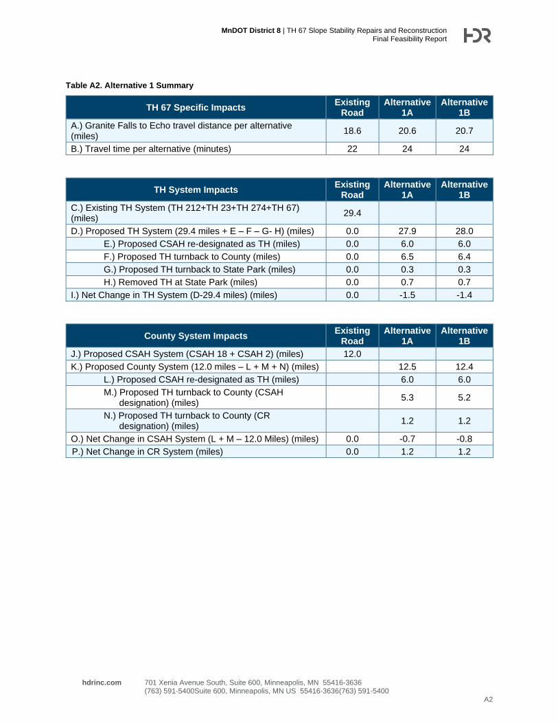
Table 1. Alternative 1 Summary .................................................................................................... 9
Table 2. Evaluation Criteria ......................................................................................................... 21
Table 3. Evaluation Matrix .......................................................................................................... 22
Table 4 Maintenance Summary .................................................................................................. 27
Table 5 Pavement Condition Summary ...................................................................................... 28
Figures
Figure 1. Vicinity Map ................................................................................................................... 1
Figure 2. TH 67 Pavement Distress, Looking West ...................................................................... 2
Figure 3. TH 67 Pavement Distress, Looking East ....................................................................... 2
Figure 4. Boring Locations ............................................................................................................ 3
Figure 5. Cross Section ................................................................................................................ 4

MnDOT District 8 | TH 67 Slope Stability Repairs and Reconstruction Final Feasibility Report
hdrinc.com 701 Xenia Avenue South, Suite 600, Minneapolis, MN 55416-3636 (763) 591-5400Suite 600, Minneapolis, MN US 55416-3636(763) 591-5400
ii
Figure 6. Washout Area at the Guardrail ...................................................................................... 5
Figure 7. Erosion at the Culvert End ........................................................................................ 5
Figure 8. Alternative 1A and 1B .................................................................................................... 8
Figure 9. Alternative 2 ................................................................................................................. 12
Figure 10. Alternative 3 ............................................................................................................... 13
Figure 11. Rip Rap Revetment with Buried Toe ......................................................................... 15
Figure 12. Rip Rap Revetment with Launchable Toe ................................................................. 15
Figure 13. Bendway Weir Typical Plan View .............................................................................. 16
Figure 14. Bendway Weir Typical Cross Section ........................................................................ 16
Figure 15. Feasibility Study Process ........................................................................................... 19
Figure 16. Alternatives Map ........................................................................................................ 23

MnDOT District 8 | TH 67 Slope Stability Repairs and Reconstruction Final Feasibility Report
hdrinc.com 701 Xenia Avenue South, Suite 600, Minneapolis, MN 55416-3636 (763) 591-5400Suite 600, Minneapolis, MN US 55416-3636(763) 591-5400
1
1 Introduction
Minnesota Department of Transportation (MnDOT) is conducting a study to develop a variety of
options to address the slope stability issues near Upper Sioux Agency State Park and to
determine the preferred alternative to maintain the connectivity of Trunk Highway (TH) 67
between Granite Falls and Echo, Minnesota. This report documents the study process,
feasibility, risk assessment, and recommendations for TH 67 near Upper Sioux Agency State
Park. TH 67 is a minor arterial between Granite Falls and Echo and provides a critical
connection for local farms and residences as well as for the Upper Sioux Community and the
State Park. TH 67 is a two-lane rural highway and predominantly has a 50-mile-per-hour posted
speed. The average daily traffic on TH 67 is 465 vehicles per day (2017 data). Figure 1 shows a
vicinity map of the project area.
Figure 1. Vicinity Map

MnDOT District 8 | TH 67 Slope Stability Repairs and Reconstruction Final Feasibility Report
hdrinc.com 701 Xenia Avenue South, Suite 600, Minneapolis, MN 55416-3636 (763) 591-5400Suite 600, Minneapolis, MN US 55416-3636(763) 591-5400
2
In April 2019, a portion of TH 67 near Upper Sioux Agency State Park was closed to traffic
because of pavement distress as a result of embankment soil movement. This portion of the
highway is constructed adjacent to the Minnesota River and crosses the Yellow Medicine River.
The geomorphology of this region suggests that this hillside has previously experienced instability.
Erosion along the Yellow Medicine River, along with fluctuations in the groundwater table, is
believed to have initiated the landslide, which has led to embankment movement, pavement
distress, and the subsequent closure of the road. Figures 2 and 3 show the impact of the landslide
on the roadway surface. These photos are from May 2019, and the displacement has only
increased over the past year. The embankment movement spans approximately 0.25-mile length
of roadway. As a result of the road closure, traffic has been detoured to a route that includes TH
274 and Yellow Medicine County State Aid Highway (CSAH) 18 (see Figure 1).
Figure 2. TH 67 Pavement Distress, Looking West Figure 3. TH 67 Pavement Distress, Looking East
To obtain information about the rate of landslide movement and the possible location of the
sliding surface, MnDOT Foundations Unit drilled four borings and installed Shape Accel Arrays,
also known as slope inclinometers, in each borehole to monitor the movement. Figure 4 shows
the boring locations. In addition, vibrating wire piezometers were installed along the hillside to
record the water table. The data is being collected and hosted by Barr Engineering. Early
indications of the monitoring showed that there was movement at a depth of 30 feet in the first
boring location (approximately 50 feet below the surface of the roadway). Additional monitoring
has revealed a secondary movement approximately 85 feet below the roadway surface, which is
near the surface elevation of the river. Figure 5 shows a cross section of TH 67 through the
landslide.

!>
!>
!>
!>
!>!>
G01C01b
T103
T102
T101
T100
LEGEND!> Geotech Borings
Distress Lines (Field Observed)
Slope (percent)High : 400Low : 0
Notes:Slope elevation derived from MnTOPO LiDAR data. MnTOPO reports LiDAR data was collected on 11/7/2010 as part of MN River Basincollection project.
Coordinate System:NAD 1983 HARN Adj MN Yellow Medicine Feet
Site OverviewSlope Instability
TH67 Granite FallsSP8707-95 Project ID: T8A722
Figure:Checked by: AJECreated by: MJH 1Version Date: 2018/06/11
Serv ice Layer Credits:
G:\GEOLOGY\PROJECTS\TH67\TH67 Granite Falls Slope Failure_SP8707-95 (2019)\ArcGIS\SP8707-95 TH67 Granite Falls - Site Overview.mxd
±0 100 20050
Feet

Vertical Exaggeration: 2x
D-D' Profile with Geologic InterpretationSP 8707-95
T.H. 67 Granite Falls (R.P. 40.1 to 40.5)
Location of movementdetected by SAA
YellowMedicine
River
T103
T102
C01b
Large crackobservedin TH67
Quaternary Deposits
Cretaceous Sediments
Granitic Residual Soil (Laterite/Saprolite)
Fill
SAA mvmt.46 ft bgs
SAA mvmt.32 ft bgs
800
850
900
950
1000
1050
0 100 200 300 400 500 600 700 800 900
Elev
atio
n (ft
am
sl)
water el.~886
Horizontal Distance (ft)Notes: -Geologic contacts are interpreted based on available data and are considered approximate.-Elevation of ground surface was generated from MnTOPO LiDAR DEM. MnTOPO reports LiDAR data was collected on 11/7/2010 as part of MN River Basin collection project. Version Date: 2019/08/26

MnDOT District 8 | TH 67 Slope Stability Repairs and Reconstruction Final Feasibility Report
hdrinc.com 701 Xenia Avenue South, Suite 600, Minneapolis, MN 55416-3636 (763) 591-5400Suite 600, Minneapolis, MN US 55416-3636(763) 591-5400
5
2 Background
The current alignment of TH 67 was constructed in the mid-1930s. This construction included
Bridge 5295 (now Bridge 87011) over the Yellow Medicine River. Before the 1930s, the
previous alignment of TH 67 went through the area that is now Upper Sioux Agency State Park,
which was not established until 1963, that is outside of the landslide area. Some of the internal
park roadways and horse trails are parts of the old highway.
Prior to the March 2019 landslide, MnDOT had observed two washout areas. Both were
localized areas behind guardrail caused by drainage runoff from the roadway surface, as shown
in Figure 6. Several of the drainage culverts through the roadway embankment in the vicinity of
the landslide area have eroded such that the pipe ends protrude from the slope, as shown in
Figure 7.
In addition, there has been movement of the east abutment of Bridge 87011 over the Yellow
Medicine River. This movement is due to a separate landslide pushing on the abutment from the
southeast. The east abutment has moved approximately 5 to 8 inches over the last 30 years,
and the rate of movement has increased in more recent years. MnDOT has made temporary
modifications to the expansion joint between the bridge deck and abutment to keep the bridge
operational. However, the expansion joint has closed as of the summer of 2020, so the
movement is creating pressure on the bridge deck.
Figure 6. Washout Area at the Guardrail Figure 7. Erosion at the Culvert End

MnDOT District 8 | TH 67 Slope Stability Repairs and Reconstruction Final Feasibility Report
hdrinc.com 701 Xenia Avenue South, Suite 600, Minneapolis, MN 55416-3636 (763) 591-5400Suite 600, Minneapolis, MN US 55416-3636(763) 591-5400
6
The landslide near Upper Sioux Agency State Park occurred gradually in late March 2019. The
Yellow Medicine River water elevation was high because of heavy winter snow melt and a
spring rainfall that was greater than normal. The roadway was closed on April 4, 2019, because
the cracking in the pavement grew too hazardous for traffic. The route has been detoured since
the closure, with traffic routed to TH 274 and CSAH 18.
Upper Sioux Agency State Park is the main adjacent landowner to the project area. The park
has two entrances. The main entrance is on top of the bluff, west of the landslide, while the
second entrance is to the camping area along the river, east of the landslide. The road closure
has severed the connection of these two entrances to the park, and there is no existing
vehicular connection within the park that is available to the public. A second landowner is
located south of the highway and adjacent to the Yellow Medicine River. This property does not
have a residence on it and is primarily used for agriculture purposes, depending the how wet the
year is and the ability to farm the land. The landowner also uses the property for recreational
purposes.
3 Assessment Goals
TH 67 serves an important role in the transportation system in southwestern Minnesota.
Minnesota State Statute 161.114 describes TH 67 as follows:
Route No. 67. Beginning at a point on Route No. 14 southerly of Echo and
thence extending in a northerly and westerly direction to a point on Route No. 17
at or near Granite Falls, affording Echo, Granite Falls and intervening and
adjacent communities a reasonable means of communication, each with the
other and other places with the state.
As noted in the State Statute, TH 67 serves as a connection between Echo and Granite Falls.
The purpose of this study is to develop a variety of options to address the slope stability issues
near Upper Sioux Agency State Park and to determine the preferred alternative to maintain the
connectivity of TH 67.
Each of the alternatives was developed to a concept level of design, and cost estimates were
prepared. Any potential project is currently unfunded, so MnDOT District 8 will need to move
funding around in their current budget, receive special emergency funding from the MnDOT
Central Office, or get funding designated through the Minnesota State Legislature. The goal of
this study is to evaluate the proposed alternatives to determine a cost-effective solution that will
re-establish the route.
4 Proposed Alternatives
The alternatives under consideration can be categorized into two general types:
• Category 1, Reroute – Move the highway out of the existing corridor to avoid the
landslide area, re-designating the TH 67 route using other existing roadways
MnDOT District 8 | TH 67 Slope Stability Repairs and Reconstruction Final Feasibility Report
hdrinc.com 701 Xenia Avenue South, Suite 600, Minneapolis, MN 55416-3636 (763) 591-5400Suite 600, Minneapolis, MN US 55416-3636(763) 591-5400
7
• Category 2, Reconstruct – Reconstruct the highway in place or near the existing
alignment, but use geotechnical solutions, such as micropiles, to stabilize the slope and
mitigate against future landslides.
Several alternatives were developed from each category. The reroute and reconstruct
alternatives carried forward for detailed evaluation in this feasibility report are discussed in
Section 4.1 and Section 4.2, respectively. The alternatives dropped from further consideration
are discussed in Section 4.3.
4.1 Reroute Alternatives
Alternative 1: Alternative 1 would reroute TH 67 outside of the existing corridor. Under
Alternative 1, existing roadway options would serve as a re-designation of TH 67 and would still
be consistent with the State Statute governing the endpoints of this portion of TH 67. Assuming
a common starting point of Granite Falls and a common end point of Echo, the base length
along the existing TH 67 alignment is 18.6 miles and typically takes 22 minutes of travel time.
Two options for rerouting TH 67 are as follows:
• Alternative 1A: TH 67 would remain on TH 23 south of Granite Falls and then would turn
east onto TH 274. The route would turn east on CSAH 18 (210th Avenue), directing
travelers back to existing TH 67, and then would continue south on TH 67 to Echo.
Alternative 1A is currently being used as the detour route while TH 67 is closed near
Upper Sioux Agency State Park.
• Alternative 1B: TH 67 would remain on TH 23 south of Granite Falls and then would turn
east onto TH 274. The route would turn east on Yellow Medicine CSAH 2 (180th
Avenue), directing travelers back to existing TH 67, and then would continue south on
TH 67 to Echo.
Alternatives 1A and 1B are shown in Figure 8.
Under either Alternative 1A or 1B, sections of existing TH 67 that would not be part of the new
alignment would need to be re-designated as a new Trunk Highway or turned back to a local
governing unit. For this analysis, it is assumed that the section of TH 67 from TH 23 to the
Upper Sioux Agency State Park main entrance (north of the road closure) would remain a Trunk
Highway. It is also assumed that TH 67 from the Yellow Medicine River to the new intersection
of the proposed TH 67 (south of the road closure) would be turned back to a local agency. It is
also assumed that the remaining segment of TH 274, south of the TH 67 re-route, would also be
turned back to a local agency.

MnDOT District 8 | TH 67 Slope Stability Repairs and Reconstruction Final Feasibility Report
hdrinc.com 701 Xenia Avenue South, Suite 600, Minneapolis, MN 55416-3636 (763) 591-5400Suite 600, Minneapolis, MN US 55416-3636(763) 591-5400
9
Common elements in both Alternatives 1A and 1B include removing the pavement and
aggregate base of the 0.6-mile section of TH 67 in the landslide area, between the main
entrance to Upper Sioux Agency State Park and the park driveway access to a park building.
This would reduce loading on the slope in the area. It is assumed that an internal park roadway
would be built to connect the main park area on top of the bluff to the campground located along
the river. Alternatives 1A and 1B assume that no riverbank protection is included as part of this
alternative. Other state or federal agencies may decide to protect the riverbank at this location,
but it would not be needed for transportation purposes. Bridge 87011 over the Yellow Medicine
River would be removed to eliminate continued maintenance or replacement of the bridge. With
no bridge, the landowner south of the existing highway would be landlocked, and either that
parcel would be purchased or access would be provided via an easement through the State
Park or a private driveway.
There are various sections of roadway that combine to make up the existing TH 67 alignment,
as well as the two rerouted alignments in Alternatives 1A and 1B. Table A1 is included in
Appendix A to describe these roadway segments.
Table 1 provides a summary of the travel distance and travel times for Alternatives 1A and 1B. It
also sums the lengths of roadway that would be removed, re-designated as new Trunk
Highways, and absorbed into the MnDOT system, as well as the net change in mileage to the
MnDOT system. A more detailed table, Table A2, can be found in Appendix A
Table 1. Alternative 1 Summary
TH 67 Specific Impacts Existing
Road Alternative
1A Alternative
1B
Granite Falls to Echo travel distance per alternative (miles) 18.6 20.6 20.7
Travel time per alternative (minutes) 22 24 24
TH System Impacts Existing
Road Alternative
1A Alternative
1B
Net Change in TH System (miles) 0.0 -1.5 -1.4
County System Impacts Existing
Road Alternative
1A Alternative
1B
Net Change in CSAH System (miles) 0.0 -0.7 -0.8
Net Change in CR System (miles) 0.0 1.2 1.2
The following initial construction costs are assumed to be necessary to re-designate either
CSAH 18 or CSAH 2 as Trunk Highway: signing, striping, rumble strips, guardrail placement at
bridges, and minor culvert maintenance. The pavement is in good to fair condition and is not in

MnDOT District 8 | TH 67 Slope Stability Repairs and Reconstruction Final Feasibility Report
hdrinc.com 701 Xenia Avenue South, Suite 600, Minneapolis, MN 55416-3636 (763) 591-5400Suite 600, Minneapolis, MN US 55416-3636(763) 591-5400
10
need of resurfacing. In addition, the traffic volumes at the intersections on either route do not
warrant turn lanes or bypass lanes.
Under either Alternative 1A or Alternative 1B, there would be a reduction in long term
maintenance for MnDOT because of the reduced lane miles of roadway and number of
structures (bridges or box culverts). There would be a slight net increase for the County in long
term maintenance due to added lane miles of roadway.
It is assumed for cost estimating purposes that the existing intersection on TH 67 at Yellow
Medicine CSAH 21 would be realigned. TH 67 has a large curve from the south to the west that
would no longer be necessary due to the roadway terminating at the Yellow Medicine River.
Realigning the roadway to align with CSAH 21, and Renville CSAH 10 north of the Minnesota
River, to the north would provide a better connection to TH 212 to the north and would better
serve the transportation needs with the proposed highway network changes.
Under Alternatives 1A and 1B, there will be sections of existing TH 67 and TH 274 that will be
turned back to the other agencies. Sections that are turned back to the County and re-
designated as CSAH roadways need to be brought up to State Aid standards including
replacement of Structure Number 6216. Structure Number 6216 is currently a 146-foot long,
double 10-foot by 10-foot box culvert at Wood Lake Creek, approximately 0.3 miles north of
CSAH 18.
4.2 Reconstruct Alternatives
Reconstruct alternatives for this project have to address three separate and distinct issues. Not
only do they need to address the roadway connection, but they need to address the root cause
of the landslide movement, which is erosion at the toe of the slope due to the Yellow Medicine
River. Lastly, reconstruct alternatives need to address the on-going landslide issues at bridge
87011. Roadway alternatives are discussed in Section 4.2.1, riverbank protection strategies are
discussed in Section 4.2.2, and bridge alternatives are discussed in Section 4.4.3.
4.2.1 Roadway Alternatives
Alternative 2: Alternative 2 would reconstruct TH 67 near the existing corridor. Under
Alternative 2, the highway would be realigned through Upper Sioux Agency State Park to
remain above the bluff and, therefore, avoid the landslide area. The connection back to existing
TH 67 would follow an existing horse trail that previously served as the old highway alignment
along the side of the bluff. The proposed roadway grade of this section along the bluff would be
approximately 8.5 percent, which exceeds the maximum design grade for this type of highway,
requiring a design exception. Current design standards are greater than those from the pre-
1930s, so this section would need to be carefully designed to avoid adding fill in the landslide
area. The necessary widening would likely cut into the face of the bluff. The existing highway
pavement and aggregate base in Alternative 2 would be removed to reduce the load on the
failing slope. The risk of the Yellow Medicine River continuing to erode the toe of the slope still
remains; even with this alternative moving the roadway outside of the current landslide area,
future larger landslides could still occur. To mitigate this risk, Alternative 2 assumes that the

MnDOT District 8 | TH 67 Slope Stability Repairs and Reconstruction Final Feasibility Report
hdrinc.com 701 Xenia Avenue South, Suite 600, Minneapolis, MN 55416-3636 (763) 591-5400Suite 600, Minneapolis, MN US 55416-3636(763) 591-5400
11
river would be armored in some fashion. This alternative also assumes that Bridge 87011 would
be replaced with a new, longer bridge, and the new design would mitigate the current landslide
issues at the bridge location. Alternative 2 is shown in Figure 9.
Alternative 3: Alternative 3 would maintain the current roadway alignment by constructing over
the landslide. Because Alternative 3 involves stabilizing the landslide, it also includes the larger
issue of controlling the Yellow Medicine River’s influence on the slope, which requires protection
of the riverbank.
Alternative 3 would reconstruct TH 67 in place after ground improvement techniques to pin the
roadway embankment to a stable layer below. MnDOT contracted with Itasca Consulting Group
to analyze the existing slope and develop possible options to pin the slope.
The preferred geotechnical solution included a system of A-shaped micropiles. The micropiles
would be 90 feet in length (depth), have a diameter of approximately 1 foot, and be spaced
horizontally every 6 feet. The overall length of the micropile system would be around 1,000 feet.
A large 7-foot-tall by 8-foot-wide concrete grade beam would be poured in place. The micropiles
would extend through the disturbed soils into an existing stiffer layer of materials. In addition to
using the micropiles and the grade beam, the roadway section is expected to be built with
lightweight fill to reduce the loading on the slope. With this alternative, it is assumed that
riverbank protection would be included to further stabilize the slope. This alternative also
assumes that Bridge 87011 would be replaced with a new, longer bridge, and the new design
would mitigate the current landslide issues at the bridge location. Alternative 3 is shown in
Figure 10, and a copy of the Itasca report, titled “TH 67 FLAC3D Analyses Results” can be
found in Appendix A.
CURVE PTH671
PI 257+44.25
X 615,267.001
Y 170,638.708
T 223.21'
L 436.54'
R 849.00'PC 255+21.04PT 259+57.58
CURVE PTH672
PI 264+22.00
X 615,942.730Y 170,511.342
T 119.58'
L 237.60'
R 849.00'
PC 263+02.42PT 265+40.02
CURVE PTH673
PI 277+87.55X 617,163.975
Y 169,896.879
T 290.23'
L 559.31'
R 849.00'
PC 274+97.32PT 280+56.63
CURVE PTH674
PI 286+85.08X 617,560.130
Y 169,068.006
T 286.61'L 552.82'
R 849.00'
PC 283+98.47
PT 289+51.29
LEGEND
PAVED ROADWAY (NEW CONSTRUCTION)
PAVED SHOULDERS
EXISTING MNDOT RIGHT OF WAY
EXISTING STATE PARK RIGHT OF WAY
{ INP. TH 67
{ INP. TH 67
{ INP. TH 67
EXISTING GROUND
EXISTING GROUND
EXISTING GROUND
1:4
SHLD
0.6'
SHLD PI
12'12'
SHLDSHLD PI
0.6' 4.5' 4.5'
{ INP. TH 67
TYPICAL SECTION - TH 67
PROPOSED
1:4
A
A
B
B
C
C
STATE PARK CONNECTION
EXISTING GROUND
PROFILEPROPOSED
10:4
9:3
3
AM
9/10/2020
c:\
pw
working\central01\d1945757\
CD870795_
Reconstruct_exhibit.d
gn
S.P.8707-95 TH 67 SLOPE STABIILTY REPAIRS AND RECONSTRUCTION
SECTION A-ASECTION B-B SECTION C-C
YELL
OW
ME
DICI
NE RI
VER
YELLOW MEDICINE RIVER
UPPER SIOUX AGENCY STATE PARK
CA
MP
GR
OU
ND
MAI
N E
NTR
ANCE
BR.# 87011
250
SCALE IN FEET
SOCIETY PROPERTY
MINNESOTA HISTORICAL
AND EMBANKMENT
REMOVE ROADWAY PAVEMENT
BRIDGE
RIVER BANK PROTECTION
PROPOSED MNDOT RIGHT OF WAY
FIGURE 9 - ALTERNATIVE 2
245
250
255
260
265
270
275
280
285
290
295
300
305
310
315
320
L = 348.659'L =
344.8
37'
L = 957.304'
L = 341.841'
L = 396.475'
PO
T. 251
+72.38
255
PC. 255
+21.04
PT. 259
+57.58
PI
260
PC. 263
+02.42
265
PT. 265
+40.02
PI
270
PC. 274
+97.32
275
280
PT. 280+56.63
PI
PC. 283+98.47
285
PT. 289
+51.29
PI 290
PO
T. 293
+47.77
900
910
920
930
940
950
960
970
980
990
1,000
1,010
1,020
1,030
1,040
1,050
253 254 255 256 257 258 259 260 261 262 263 264 265 266 267 268 269 270 271 272 273 274 275 276 277 278 279 280 281 282 283 284 285 286 287 288 289900
910
920
930
940
950
960
970
980
990
1,000
1,010
1,020
1,030
1,040
1,050
253 254 255 256 257 258 259 260 261 262 263 264 265 266 267 268 269 270 271 272 273 274 275 276 277 278 279 280 281 282 283 284 285 286 287 288 289 290 291 292900
910
920
930
940
950
960
970
980
990
1,000
1,010
1,020
1,030
1,040
1,050
253 254 255 256 257 258 259 260 261 262 263 264 265 266 267 268 269 270 271 272 273 274 275 276 277 278 279 280 281 282 283 284 285 286 287 288 289 290 291 292900
910
920
930
940
950
960
970
980
990
1,000
1,010
1,020
1,030
1,040
1,050
253 254 255 256 257 258 259 260 261 262 263 264 265 266 267 268 269 270 271 272 273 274 275 276 277 278 279 280 281 282 283 284 285 286 287 288 289 290 291 292900
910
920
930
940
950
960
970
980
990
1,000
1,010
1,020
1,030
1,040
1,050
253 254 255 256 257 258 259 260 261 262 263 264 265 266 267 268 269 270 271 272 273 274 275 276 277 278 279 280 281 282 283 284 285 286 287 288 289 290 291 292900
910
920
930
940
950
960
970
980
990
1,000
1,010
1,020
1,030
1,040
1,050
253 254 255 256 257 258 259 260 261 262 263 264 265 266 267 268 269 270 271 272 273 274 275 276 277 278 279 280 281 282 283 284 285 286 287 288 289 290 291 292900
910
920
930
940
950
960
970
980
990
1,000
1,010
1,020
1,030
1,040
1,050
1,041.23
VPI
+50.00
EL. 1,018.28
-4.50%+3.0
0%
750.00' V.C.
K = 100
ex = 7.03'
VPI
+50.00
EL. 1,036.28
+3.0
0%
-0.55%
399.99' V.C.
K = 113
ex = -1.77'
SSD = 387'
VPI
+70.00
EL. 1,029.02
-0.55%
-8.50
%
675.75' V.C.
K = 85
ex = -6.72'
SSD = 336'
VPI
+6
7.7
6
EL. 9
27.2
1
-8.50
%
-4.30%
524.17' V.C.
K = 125
ex = 2.75'
91
0.00
VP
C
+75.00
EL. 1,035.15
VP
T
+25.00
EL. 1,029.53
VP
C
+50.00
EL. 1,030.28
VP
T
+50.00
EL. 1,035.18
VP
C
+32.13
EL. 1,030.88
VP
T
+07.87
EL. 1,000.30
VP
C
+05.68
EL. 949.49
VP
T
+29.85
EL. 915.94
1,0
38.5
3
1,0
34.0
6
1,0
30.3
1
1,0
27.5
6
1,0
25.8
1
1,0
25.0
6
1,0
25.3
1
1,0
26.5
6
1,0
28.8
1
1,0
31.6
7
1,0
33.7
8
1,0
35.0
1
1,0
35.3
4
1,0
34.9
0
1,0
34.3
5
1,0
33.8
0
1,0
33.2
5
1,0
32.7
0
1,0
32.1
5
1,0
31.6
0
1,0
31.0
5
1,0
30.2
3
1,0
28.3
0
1,0
25.1
8
1,0
20.8
9
1,0
15.4
3
1,0
08.7
8
1,0
00.9
7
99
2.4
7
98
3.9
7
97
5.4
7
96
6.9
7
95
8.4
7
94
9.9
7
94
1.8
3
93
4.4
8
92
7.9
4
92
2.2
0
91
7.2
6
91
2.9
2
.06
.061:21:3
1:21:3
1:21:3
1:31:2
.04
.02.04.04
.02
9/10/2020
10:49:33
AM
c:\p
wworkin
g\central0
1\d
19
45
757\
CD870795_
Reconstruct_exhibit.dgn

11/24/2019
y
TH67 - Preliminary Analysis
Potential improvements
A-Shaped MicropilesMicropile D = 0.30 mSteel pipe 240 mm Th 12.5 mm.Spacing 2 m
UNDISTURBED GLACIAL SOILS
VERY STIFF MATERIAL (SHALE/SILTSTONE/CLAY)
SAPROLITE/RESI DUAL
Slide 32
S FF GLACIAL SOILS
GEOMECHANICS • HYDROGEOLOGY • MICROSEISMICS : MINING • CIVIL • ENERGY
Figure 10 - Alternative 3

MnDOT District 8 | TH 67 Slope Stability Repairs and Reconstruction Final Feasibility Report
hdrinc.com 701 Xenia Avenue South, Suite 600, Minneapolis, MN 55416-3636 (763) 591-5400Suite 600, Minneapolis, MN US 55416-3636(763) 591-5400
14
4.2.2 Riverbank Protection Strategies
Several options were considered for protection of the riverbank, including the following:
• Option A: Protective Wall Along the Toe of the Slope (Riverbank) – A protective wall
would be constructed along the toe of the slope to shield against further erosion and
future landslides. Given the volume of material uphill of the wall, the design assumes
55-foot-deep shafts for a poured-in-place concrete pile with a 7-foot horizontal shaft
spacing for a length spanning 811 feet along the riverbank. This option would be the
most costly to construct but would provide the highest factor of safety to protect the
slope against future landslides. Additional costs for clearing and grubbing, and a
temporary access road for construction equipment and trucks are included.
• Option B: Rip Rap with Buried Toe – Rip rap would armor the riverbank and would be
buried to the maximum scour depth of the river, as shown in Figure 11. Scour depths of
the Yellow Medicine River are currently unknown, but for the purposes of this report, the
depth was estimated to be 20 feet. At that depth, there would be substantial impacts on
the river to install the buried toe. The maximum size of rip rap needed for this option is
greater than the MnDOT specifications for Class 5 rip rap. Additional costs for clearing
and grubbing, and a temporary access road for construction equipment and trucks are
included.
• Option C: Rip Rap with Launchable Toe – Rip rap would armor the riverbank and would
be thickened at the toe of the embankment slope, as shown in Figure 12. As the riverbed
scours, the additional rip rap would fall down the slope to armor the newly exposed
surface. The maximum size of rip rap needed for this option is greater than the MnDOT
specifications for Class 5 rip rap. Additional costs for clearing and grubbing, and a
temporary access road for construction equipment and trucks are included.
• Option D: Bendway Weirs – A series of weirs would be added to the outside of the river
channel where the river velocity is the greatest, as shown in Figures 13 and 14. The
weirs would slow down the water and would reduce the likelihood of erosion at the toe of
the slope. The maximum size of rip rap needed for this option is greater than the MnDOT
specifications for Class 5 rip rap. Additional costs for clearing and grubbing, and a
temporary access road for construction equipment and trucks are included.

MnDOT District 8 | TH 67 Slope Stability Repairs and Reconstruction Final Feasibility Report
hdrinc.com 701 Xenia Avenue South, Suite 600, Minneapolis, MN 55416-3636 (763) 591-5400Suite 600, Minneapolis, MN US 55416-3636(763) 591-5400
15
Figure 11. Rip Rap Revetment with Buried Toe
Figure 12. Rip Rap Revetment with Launchable Toe

MnDOT District 8 | TH 67 Slope Stability Repairs and Reconstruction Final Feasibility Report
hdrinc.com 701 Xenia Avenue South, Suite 600, Minneapolis, MN 55416-3636 (763) 591-5400Suite 600, Minneapolis, MN US 55416-3636(763) 591-5400
16
Figure 13. Bendway Weir Typical Plan View
Figure 14. Bendway Weir Typical Cross Section
MnDOT District 8 | TH 67 Slope Stability Repairs and Reconstruction Final Feasibility Report
hdrinc.com 701 Xenia Avenue South, Suite 600, Minneapolis, MN 55416-3636 (763) 591-5400Suite 600, Minneapolis, MN US 55416-3636(763) 591-5400
17
• Option E: Bioengineered Solutions – Bioengineered solutions would include using items
such as large woody material and brush mattress for erosion control. Similar to the rip
rap options (Options B, C, and D), the bank would be covered with stumps, downed
trees, and other brush materials to act as protection for the riverbank. This option is
typically used for smaller streams where the velocity is not as great as it is in the Yellow
Medicine River. The option was reviewed and deemed not appropriate for this location.
The solution was not further investigated.
Cost estimates presented are preliminary based on the information available at the time of the
study. Following review of the options previously noted, Options A and E were dismissed from
further consideration. Option A is too costly, and Option E was deemed not viable due to the
velocity of the river current. To proceed with Options B through D, a detailed survey of the river
bottom would be required to understand the river characteristics. A detailed hydraulic analysis,
complete with two-dimensional models, would be needed to confirm results and assumptions.
Each option offers a different level of protection, which should be considered when evaluating
stabilization options near the roadway. In each of these options, there are likely substantial
environmental impacts associated with the construction of the riverbank protection strategy in
addition to accessing the site.
4.2.3 Yellow Medicine River Bridge Strategies
Bridge 87011 has also been an on-going maintenance issue for MnDOT. As noted earlier, there
is a second smaller slide that is pushing on the east abutment. In the reconstruct alternatives,
this bridge at the Yellow Medicine River needs to be addressed to maintain the connection
between Granite Falls and Echo. MnDOT contracted with Itasca Consulting Group to analyze
the existing slope and develop possible options to pin the slope. They developed a similar a-
frame micropile system with a grade beam to address the slide issue and alleviate the
movement on the abutment. This solution would require a specialty contractor and extensive
monitoring. In addition, the bridge superstructure would be removed to permit the construction
to occur. This solution was determined to be overly complicated and not cost effective. As a
result, a new, longer bridge that would span the slide area is a more desirable solution. This
cost has been assumed on all reconstruction alternatives. A copy of the Itasca report, titled “TH
67 Br 87011 FLAC3D Back Analysis” can be found in Appendix B.
4.3 Alternatives Dropped from Further Consideration
The alternatives discussed in this section were dropped from further consideration because they
were determined to be too costly or did not provide a high enough factor of safety, or both.
Category 1, Reroute: In addition to Alternatives 1A and 1B, two other reroute alternatives were
considered. While both alternatives would satisfy the base requirements of the State Statute,
they were determined to be less desirable than Alternatives 1A and 1B.
Beginning in Granite Falls, the first reroute alternative dropped from further consideration would
stay on TH 212 instead of turning south on TH 23 to cross the Minnesota River. It would follow
TH 212 roughly 7.5 miles east and then would turn south on Renville CSAH 10. This county

MnDOT District 8 | TH 67 Slope Stability Repairs and Reconstruction Final Feasibility Report
hdrinc.com 701 Xenia Avenue South, Suite 600, Minneapolis, MN 55416-3636 (763) 591-5400Suite 600, Minneapolis, MN US 55416-3636(763) 591-5400
18
road crosses the Minnesota River and becomes Yellow Medicine CSAH 21. It intersects with
existing TH 67 a little less than 2 miles east of the landslide area. This alignment would add the
fewest new miles to the MnDOT system, but it would not offer as much roadway to turn back to
a local agency. Therefore, it would add the most net new miles to the MnDOT system. The
alternative would also add a substantial river bridge (over the Minnesota River). This alternative
had the highest annual maintenance cost of all the reroute options. Finally, it is the lengthiest of
the reroute options at 21.6 miles long between Granite Falls and Echo, or 3 miles longer than
the existing route.
The second reroute alternative dropped from further consideration is similar to Alternatives 1A
and 1B. On this route, TH 67 would remain on TH 23 south of from Granite Falls and then would
turn east onto TH 274. The route would continue south on TH 274 into Wood Lake, Minnesota.
TH 274 terminates in Wood Lake, but the roadway continues south as Yellow Medicine
CSAH 6. The route would continue on CSAH 6 to Yellow Medicine CSAH 1 (150th Avenue) and
then would turn east to follow CSAH 1 into Echo. Overall, this alignment was a similar length to
Alternatives 1A and 1B; and it provides the greatest opportunity to turn back portions of TH 67
to a local agency leading to potential reduced system maintenance costs. However, it added the
most miles to the MnDOT system of all of the reroute alternatives and therefore was the most
costly of the reroute alternatives considered.
Category 2, Reconstruct: In addition to Alternatives 2 and 3, two other reconstruct alternatives
were considered. The first reconstruct alternative dropped from further consideration included a
land bridge across the landslide area. The bridge would be approximately 840 feet long. Deep
foundations using drilled shafts approximately 85 feet deep were estimated to accommodate the
earth pressure load from a potential future landslide. The drilled shafts would extend through the
slip planes to bedrock. The volume of earth in the landslide area is substantial, and distribution
of load to the shafts would need to be determined. Because of the horizontal landslide
movement, the foundations would need to be oversized to resist the lateral load, as well as
possibly a design to allow movement of soil around the foundation as the landslide movement
continues, if this soil movement allowance is possible. The existing roadway embankment would
be removed below the beams to reduce the load on the slope, eliminate soil pressure on the
bridge superstructure, and re-establish drainage patterns. Through the analysis, it was
determined that riverbank protection would benefit the design and long-term maintenance of the
bridge. However, riverbank protection does not mitigate the landslide movement and does not
eliminate the risk of lateral bridge movement.
The second reconstruct alternative dropped from further consideration was reconstructing the
roadway embankment of TH 67 in place using lightweight fill to reduce the load of the roadway
on the slope, combined with riverbank protection to reinforce the conditions at the base of the
landslide. MnDOT’s Foundations Unit evaluated the use of lightweight fill as a replacement for
soil in the road embankment to reduce load on the landslide as a mitigation measure to reduce
future landslide movement. A series of figures were developed from the analysis to illustrate the
site conditions.

MnDOT District 8 | TH 67 Slope Stability Repairs and Reconstruction Final Feasibility Report
hdrinc.com 701 Xenia Avenue South, Suite 600, Minneapolis, MN 55416-3636 (763) 591-5400Suite 600, Minneapolis, MN US 55416-3636(763) 591-5400
19
A limit equilibrium model was run on the pre-landslide conditions and on a scenario where the
entire 20-foot roadway embankment was replaced with lightweight fill. The limit equilibrium
model analyzes the slope stability and provides a factor of safety given certain site conditions.
MnDOT’s analysis showed a slight increase in the factor of safety of only 0.12 and an overall
factor of safety just shy of 1.2, which is not acceptable per American Association of State
Highway Transportation Officials requirements.
A finite element model was also run to provide strain and displacement data. Finite element
models are more complex than the limit equilibrium model and provided greater insight into the
kinematics of the slope. What this analysis showed was that a lightweight fill roadway
embankment has a negative effect on the slope above the roadway. The analysis showed that
there is greater strain, or a destabilization, in these soils due to a loss of counterbalance of the
roadway embankment with the reduced weight of the lightweight fill. Therefore, the lightweight
fill option would require additional mitigation to the upper slope as well.
MnDOT Foundations Unit concluded that the lightweight fill option is not feasible given the low
factor of safety and the additional work and cost required to stabilize the upper slope.
5 Evaluation Process and Criteria
For evaluating the alternatives, a process was developed to establish the positives and
negatives of each alternative as well as to conduct a risk assessment to review potential
impacts. Figure 15 summarizes the main components of the evaluation process.
Identify and Recommend Alternatives
Reroute
Reconstruct
Identify and Document Impacts
Highway User Impacts
Landowner Impacts
Constructability
Schedule
Environmental Impacts
Maintenance
Analyze Impacts
Select Preferred Alternative
Figure 15. Feasibility Study Process

MnDOT District 8 | TH 67 Slope Stability Repairs and Reconstruction Final Feasibility Report
hdrinc.com 701 Xenia Avenue South, Suite 600, Minneapolis, MN 55416-3636 (763) 591-5400Suite 600, Minneapolis, MN US 55416-3636(763) 591-5400
20
The evaluation criteria for these TH 67 alternatives are largely based on typical value
engineering criteria, such as highway operations, local road operations, and impacts on
construction, schedule, the environment, and maintenance. To identify and document impacts of
the alternatives presented in Section 4, the following types of impacts were considered:
• Highway User Impacts – Determine impacts on the traveling public, including travel time,
route distance, and grade changes.
• Initial Cost – Cost is important given that funding has not been secured for this project
and its need will compete with other projects across Minnesota.
• Environmental Impacts – Determine impacts on various expected environmental issues,
including cultural resources, historic properties, Section 6(f), and areas of biodiversity.
• Landowner Impacts – Assess how adjacent landowners would be impacted in regard to
access and right-of-way.
• Maintenance – Any new construction will have differing long-term maintenance
consequences compared to maintenance activities prior to the landslide. Maintenance
impacts will be reviewed in relation to both the roadway and bridge.
• Constructability – Identify special or unusual design and construction activities that may
require a specialty contractor and a have a higher associated risk.
For each criterion developed, an evaluation objective was identified, as was a measure for
comparison purposes. The evaluation criteria include both quantitative and qualitative
measures. Table 2 summarizes the evaluation criteria. Each alternative was screened based on
these criteria to inform the feasibility and risk assessment, discussed in Section 6.

MnDOT District 8 | TH 67 Slope Stability Repairs and Reconstruction Final Feasibility Report
hdrinc.com 701 Xenia Avenue South, Suite 600, Minneapolis, MN 55416-3636 (763) 591-5400Suite 600, Minneapolis, MN US 55416-3636(763) 591-5400
21
Table 2. Evaluation Criteria
Evaluation Criterion Evaluation Criterion Evaluation Objective Measures for Comparison
Highway User Impacts Travel time Increase or decrease from existing
• Travel time (min)
Highway User Impacts Route distance Increase or decrease from existing
• Distance (miles)
Highway User Impacts Grade changes Increase or decrease from existing
• Roadway grades (%)
Initial Cost Total Project Cost Estimate
Construction Cost, right-of-way, and engineering
• Cost ($)
Environmental Impacts Cultural resources Identify Locations of impact
• Risk of impact
Environmental Impacts Historic properties Identify Locations of impact
• Risk of impact
Environmental Impacts Section 6(f) Identify Locations of impact
• Risk of impact
Environmental Impacts Areas of biodiversity Identify Locations of impact
• Risk of impact
Landowner Impacts Access Access impacts • Mitigation to maintain
access
Locations for
Landowner Impacts Right of Way permanent and temporary right-of-way acquisition
• Risk of right-of-way impact (acres)
Maintenance State Maintenance Increase or decrease from existing
• Roadway length (miles)
Maintenance State Maintenance Increase or decrease from existing
• Bridge area (SF)
Maintenance Yellow Medicine County Maintenance
Increase or decrease from existing
• Roadway length (miles)
Maintenance Yellow Medicine County Maintenance
Increase or decrease from existing
• Area (SF)
Constructability Construction Schedule Constructability Review • Year of construction
completion
Constructability Construction Complexity
Constructability Review • Comparison to
standard methods
6 Feasibility and Risk Assessment
The feasibility and risk assessment of TH 67 is based on evaluating each alternative with
respect to the evaluation criteria in comparison to the existing alignment prior to the landslide
and subsequent closure of the roadway. The summary of the feasibility and risk assessment is
presented in Table 3. A more detailed table can be found in Appendix A. Environmental
concerns are shown in Figure 16.

MnDOT District 8 | TH 67 Slope Stability Repairs and Reconstruction Final Feasibility Report
hdrinc.com 701 Xenia Avenue South, Suite 600, Minneapolis, MN 55416-3636 (763) 591-5400Suite 600, Minneapolis, MN US 55416-3636(763) 591-5400
22
Table 3. Evaluation Matrix
Criterion Alternative 1A
(Reroute on CSAH 18)
Alternative 1B
(Reroute on CSAH 2)
Alternative 2
(Reconstruct through State Park)
Alternative 3
(Reconstruct in Place)
Highway User Impacts • 2 minutes of
travel time additional • 2 minutes of
travel time additional
• No change • No change
Initial Cost • $12.1M-$14.3M • $12.1M-$14.3M • $22.7M-$30.2M • $37.9M-$46.5M
Environmental Impacts • Low probability of
environmental impacts
• Low probability of environmental impacts
• High probability of cultural resource and Section 6(f) impacts
• High probability of cultural resource and Section 6(f) impacts
Landowner Impacts • Access impacts to
State Park and local residents
• Access impacts to State Park and local residents
• Right-of-way acquisition from DNR (State Park)
• Right-of-way acquisition from DNR (State Park)
Maintenance
•
•
Net decrease to State annual maintenance cost
Net increase to County and DNR annual maintenance cost
•
•
Net decrease to State annual maintenance cost
Net increase to County and DNR annual maintenance cost
•
•
Slight increase to State annual maintenance cost
No change to County annual maintenance cost
• No change to State or County annual maintenance cost
Constructability • Standard construction
methods
• Standard construction methods
• Significant risk of delay in schedule due to project complexity
• Significant risk of delay in schedule due to project complexity

")22")25 ")47
")48
")38")45
")6
")44
")21
")3
")10
")39
")2
")18
")17
")37
850th Ave
CR-A1600
th St
590th S
t
620th S
t
580th S
t800th Ave
560th S
t
266th Ave
Chipp
ewa-R
enville
AveSE
220th Ave
130th S
t
170th Ave
T-190
250th Ave
557th St
830th Ave
180th Ave
140th St SE
535th S
t
Palmer Creek Rd
T-117
40thA
veSE
120th S
t
Railroad
CR-40
Traverse La
160th St
260th Ave
270th Ave
140th S
t
230th Ave
200th Ave
820th Ave822nd Ave
567th S
t
860th Ave
840th Ave540
th St
565th S
t
240th Ave
190th Ave
210th Ave
570th S
t218th Ave
150th St SE
115th S
t
Petes Point Rd
Petes
Point
RdSE
170th St SE
810th Ave
222nd Ave
T-291
555thS
t
123rd St
145th S
t
29 28 27 26 25 30 29 28 27 26 25
32 3334
35 32 33 34 35
5 4 3 2 5 4 3 2
8 910 11 12 7 8 9 10 11
1716 15 14
1318 17 16
15 14
2021 22 23 24 19
2021 22 23
29 28 27 26 25 30 2928
27 26
32 3334
35 32 33 34 35
5 4 3 2 5 4 3 2
8 9 10 11 12 7 8 9 10 11
17 16 15 14 13 18 17 16 15 14
2021 22 23 24 19 20 21 22 23
29 28 27 26 25 30 29 28 27 26
32 33 34 35 32 33 34 35
36T116N-R39W
1T115N-R39W
6T115N-R38W
36T115N-R39W
31T115N-R38W
1T114N-R39W
6T114N-R38W
?A67
?A274
?A67
?A23
?A274
?A67 £¤212County D itch 39
Coun ty Ditch
9
C ounty
Ditch
66
Co unty
Ditch
6A
Boiling Spring Creek
Unnam e d Stream
Cou nty Ditch 36
County Ditch 2Wood
Lake
Creek
HawkCreek
Yellow
Medicine River
Minnesota River
Gneiss Outcrops
UpperSioux
Agency
Blue DevilValley
Wood LakeHighbank
Lake
Kvistid LakeMud Lake
LoneTreeLake
PATH: \\MSPE-GIS-FILE\GISPROJ\MNDOT\10170518_GRANITEFALLS\7.2_WIP\MAP_DOCS\DRAFT\HWY67_8X11P.MXD - USER: STUOHEY - DATE: 9/10/2020
0 1MilesO
LEGENDTH67Alternative 1AAlternative 1BAlternative 2Alternative 3PWI StreamPWI BasinScientific and Natural AreaState ParkNWI Wetland
Biodiversity SignificanceBelowModerateHigh

MnDOT District 8 | TH 67 Slope Stability Repairs and Reconstruction Final Feasibility Report
hdrinc.com 701 Xenia Avenue South, Suite 600, Minneapolis, MN 55416-3636 (763) 591-5400Suite 600, Minneapolis, MN US 55416-3636(763) 591-5400
24
7 Stakeholder and Public Input
In addition to, but separate from, the evaluation process, stakeholder input was sought through
a detailed public and agency involvement process. Because several key stakeholders will be
influenced in different ways by the selection of a preferred roadway alternative, there has been
a concerted effort to engage these stakeholders and gather their input. The input has been
solicited not to develop the roadway alternatives but rather to understand the impacts of the
proposed roadway alternatives on the stakeholders and to determine the level of support for any
or all of the alternatives.
7.1 Stakeholder Input
The following is a listing of the stakeholders whose input was sought through the engagement
process.
• Upper Sioux Community Leadership and Tribal Historic Preservation Officer (THPO)
• Minnesota DNR/Upper Sioux Agency State Park
• Yellow Medicine County
• Renville County
• City of Echo
• City of Granite Falls
• City of Wood Lake
• Local Emergency Responders
• School District and Bussing Companies
• Upper Minnesota Valley Regional Development Commission
Upper Sioux Community Leadership and Tribal Historic Preservation Officer expressed
concerns regarding Alternatives 2 and 3 due to the high probability of cultural resource impacts.
The City of Wood Lake has expressed preference for Alternative 1B due to being routed
adjacent to Wood Lake.
7.2 Public Input
Below is a summary of the public engagement activities performed.
Mailed letter to approximately 250 impacted landowners between TH 67, TH 274, and
CSAH 2. The letter contained project details, timelines, and potential solutions, and
provided an opportunity to communicate directly with the project manager. This resulted
in 26 direct conversations between interested stakeholders and the project manager.
• Meetings with landowners, farm owners and managers, area residents, and Yellow
Medicine County Commissioners
• Common themes included access to State Park, scenery/scenic byway, property
impacts, access to Wood Lake, traffic, visibility/sightlines, and drainage.

MnDOT District 8 | TH 67 Slope Stability Repairs and Reconstruction Final Feasibility Report
hdrinc.com 701 Xenia Avenue South, Suite 600, Minneapolis, MN 55416-3636 (763) 591-5400Suite 600, Minneapolis, MN US 55416-3636(763) 591-5400
25
• In general, residents closest to the State Park and the Yellow Medicine River bridge
were concerned about losing existing TH 67 connection
A virtual open house was held July 27th through August 9th, 2020 containing project details,
timelines and potential solutions, with an opportunity to provide feedback. The virtual open
house was advertised via post cards, newspaper ads, social media, and the project website.
• 947 visitors, some multiple visits
• 12 minutes average time spent on the web page
• 26 comments via the virtual open house and the project website
• Survey question, which reroute option can you support. 59 responses, 38 for Alternative
1A, 17 for Alternative 1B, and 4 for either.
• Reasons for selecting Alternative 1A: shortest connection back to existing TH 67, does
not travel near Wood Lake, does travel by Historic Wood Lake Battlefield, Timm County
Park, and Rock Valley Church, less highway turned back to local government
• Reasons for selecting Alternative 1B: Does travel near Wood Lake, better visibility/sight
lines, wider road, more State highway turned back to local government.
8 Summary
Further analysis of the evaluation criteria for the four alternatives and a final recommended
preferred alternative are provided in the following paragraphs.
Highway user impact
TH 67 serves 465 vehicles per day, the traffic volumes on this section are among the
lowest five percent of Trunk Highways in District 8. The feasibility and risk assessment
performed in section 6 indicates that there is a minor two-minute increase in travel time
for most highway users for Alternatives 1A and 1B. It is acknowledged that there is
potential for approximately 15-minute increase in travel time for landowners located
within a couple miles of the road closure to get from one side of the Yellow Medicine
River to the other. From a highway system standpoint, all alternatives are relatively
equal.
Total Project Cost
Expected total project costs are as follows:
Alternative 1A range $12.1M to $14.3M
Alternative 1B range $12.1M to $14.3M
Alternative 2 range $22.7M to $30.2M
Alternative 3 range $37.9M to $46.5M
MnDOT District 8 | TH 67 Slope Stability Repairs and Reconstruction Final Feasibility Report
hdrinc.com 701 Xenia Avenue South, Suite 600, Minneapolis, MN 55416-3636 (763) 591-5400Suite 600, Minneapolis, MN US 55416-3636(763) 591-5400
26
Initial costs are significantly greater for Alternatives 2 and 3, primarily because they not
only include cost to reconstruct TH 67 but also stabilize the riverbank and replace the
existing bridge over the Yellow Medicine River. Alternatives 1A and 1B are preferred for
initial cost.
Environmental impacts
Alternatives 2 and 3 both have high probabilities of disturbing cultural and/or historical
resources. Likewise, both these alternatives have a high probability of incurring Section
6(f) impacts to the State Park. Both alternatives also have impacts to naturally wooded
areas of Moderate Biodiversity significance. In comparison, Alternatives 1A and 1B
have little to no environmental impacts as they use existing roadways. As a result,
Alternatives 1A and 1B are preferred from an environmental standpoint.
Landowner Impacts
Under both Alternatives 1A and 1B, there are impacts to access for the State Park.
Under either of these alternatives, an internal State Park Road to connect the main
entrance of the Park on top of the bluff to the State Park Campground is needed to
address the access. There is also a private parcel of property that becomes landlocked.
There is also additional R/W and construction needed at the existing TH 67 and CSAH
21 intersection to realign the intersection.
Under Alternative 2, over 13 acres of property is needed from the park for the realigned
TH 67 through the Park, although there is the opportunity to offset that by vacating the
R/W of the existing highway. Under both Alternatives 2 and 3, there is a need for
temporary easements on over 15 additional acres to construct the improvements along
the river and/or to construct the geotechnical improvements to stabilize the roadway. In
both Alternatives, there would be extensive tree clearing required for the necessary
temporary roadways and permanent construction.
The R/W cost is a relative minor cost to the overall project. On its own merit, landowner
impacts are neutral across all alternatives.
Maintenance
Maintenance is an annual cost that agencies must account for to keep their highway and
bridges serviceable to the traveling public. Alternatives 2 and 3 are similar in length to
the existing TH 67 route. Alternative 2 is slightly longer and would add a steep grade of
8.5% so a minor cost add would be expected, while Alternative 3 would be expected to
be the same as today.
Alternative 1A and 1B both offer similar costs. Alternative 1A reduces 1.5 miles from the
Trunk Highway System in District 8, increases 0.5 miles to the County Highway System,
and increases 0.6 miles to the DNR. It does add bridge 87054 on CSAH 18 to the State
inventory but also eliminates the bridge 87011 over the Yellow Medicine River from the

MnDOT District 8 | TH 67 Slope Stability Repairs and Reconstruction Final Feasibility Report
hdrinc.com 701 Xenia Avenue South, Suite 600, Minneapolis, MN 55416-3636 (763) 591-5400Suite 600, Minneapolis, MN US 55416-3636(763) 591-5400
27
system and turns back bridge 6216 (the double 10’ by 10’ box culvert) to the County.
Still there is an expected reduction in annual maintenance costs for Alternative 1A.
For Alternative 1B, there is a reduction of 1.4 miles to the Trunk Highway system in
District 8, increases 0.4 miles to the County Highway System, and increases 0.6 miles to
the DNR. It does add bridge 87554 on CSAH 18 to the State inventory but also
eliminates the bridge 87011 over the Yellow Medicine River from the system and turns
back bridge 6216 (the double 10’ by 10’ box culvert) to the County. So there is also an
expected reduction in annual maintenance costs for Alternative 1B.
Table 4 Maintenance Summary
Alternative 1A
Roadway (miles)
Alternative Roadway 1A Bridge
(each)
Alternative 1B
Roadway (miles)
Alternative 1B Bridge
(each)
Alternative 2 Roadway
(miles)
Alternative 3 Roadway
(miles)
+ 87054 + 87554 State -1.5 - 87011
- 6216 -1.4 - 87011
- 6216 N/C N/C
County 0.5 - 87054 +6216
+ 0.4 - 87554 +6216
N/C N/C
DNR 0.6 N/C + 0.6 N/C N/C N/C
In regards to Maintenance, removal of the Yellow Medicine River bridge eliminates a
major annual maintenance cost. Alternative 1A or 1B is the preferred alternative.
Constructability
Alternatives 2 and 3 are much more complex than Alternatives 1A and 1B. Both include
a River Bridge replacement and riverbank protection in addition to the roadway
reconstruction. Alternative 3 also adds a costly and specialized design and construction
of a geotechnical system to stabilize the roadway. Alternatives 1A and 1B are both
simpler construction projects and take place on roadways that are already in place.
Alternatives 1A and 1B are preferred in regards to constructability.
Alternatives 2 and 3 are not recommended for further consideration due to significant
environmental concerns and high cost.
8.1 Recommendation
Alternative 1A and 1B have similar impacts based on the criteria above; additional evaluation
criteria are needed to further analyze the recommended route. The additional criteria used for
evaluation are the engineering properties of the route: roadway geometrics, bridge condition,
pavement condition, and culvert conditions.

MnDOT District 8 | TH 67 Slope Stability Repairs and Reconstruction Final Feasibility Report
hdrinc.com 701 Xenia Avenue South, Suite 600, Minneapolis, MN 55416-3636 (763) 591-5400Suite 600, Minneapolis, MN US 55416-3636(763) 591-5400
28
Roadway geometrics
Both CSAH 2 and CSAH 18 are rural roadways with 12’ lanes and 5’ gravel shoulders.
Per as-built plans, both roadways have 1:4 side slopes and similar clear zones.
Roadway geometrics is neutral to either alternative.
Intersection Sight Distance
Both Alternative 1A and 1B introduce new turning movements at TH 274 and TH 67 for
through travel on TH 67. Intersection sight distance is an important factor given the
expected increase in traffic volumes at these intersections. At CSAH 18 on TH 67, there
is a steep grade and a crest vertical curve to the north of the intersection that can limit
the sight distance for traffic on CSAH 18. At CSAH 2 on TH 67, the grades are much
flatter allowing greater sight distances. As a result, Alternative 2 is preferred for the
better sight distance at the intersections.
Bridge Condition
Bridge 87504 on Alternative 1A is a precast channel span with timber abutments and
piling, constructed in 1966. The bridge width is 30’, which is narrower than the roadway.
This structure type has a limited remaining service life and needs replacement if on the
Trunk Highway system. Bridge 87554 on Alternative 1B is a prestressed concrete beam
bridge, constructed in 2001. The bridge width is 36’ and matches the roadway width.
Alternative 1B is preferred due to bridge geometrics and condition.
Pavement condition
The following table describes the dates and ranges of the previous County resurfacing
projects.
Table 5 Pavement Condition Summary
Roadway Construction Date From To Pavement Section
Alternative 1A (CSAH 18)
2001 (SAP 087-618-018)
TH 274 TH 67 Bit. Wear Course - 1.5”
Bit. Non-Wear Course – 6” Aggregate Base – 5.5”
Alternative 1B (CSAH 2)
2011 (SAP 087-602-021)
TH 274 567th Street
Bit. Wear Course - 1.5” Bit. Non-Wear Course – 5”
Aggregate Base – 3.5”
Alternative 1B (CSAH 2)
2001 (SAP 087-602-018)
567th Street
580th Street
Bit. Wear Course - 1.5” Bit. Non-Wear Course – 6”
Aggregate Base – 5.5”
Alternative 1B (CSAH 2)
2018 (SAP 087-602-026)
580th Street
TH 67 Bit. Wear Course - 1.5”
Bit. Non-Wear Course – 2” Mill – 1.5”
Alternative 1B is preferred due to better pavement condition compared to Alternative 1A.

MnDOT District 8 | TH 67 Slope Stability Repairs and Reconstruction Final Feasibility Report
hdrinc.com 701 Xenia Avenue South, Suite 600, Minneapolis, MN 55416-3636 (763) 591-5400Suite 600, Minneapolis, MN US 55416-3636(763) 591-5400
29
Culvert conditions
A hydraulic review and preliminary recommendation was completed on Alternative 1A
and 1B. Alternative 1A needs approximately six culvert liners, and culvert cleaning.
Alternative 1B needs approximately two culvert liners, and no culvert cleaning.
Alternative 1B is preferred due to better condition of existing culverts.
Final Recommendation
Considering all these additional criteria, Alternative 1B, rerouting TH 67 onto TH 23, TH
274, and CSAH 2, is the recommended alternative to re-establish TH 67 between
Granite Falls and Echo.

MnDOT District 8 | TH 67 Slope Stability Repairs and Reconstruction Final Feasibility Report
hdrinc.com 701 Xenia Avenue South, Suite 600, Minneapolis, MN 55416-3636 (763) 591-5400Suite 600, Minneapolis, MN US 55416-3636(763) 591-5400
Appendix A
TH 67 Background Information

MnDOT District 8 | TH 67 Slope Stability Repairs and Reconstruction Final Feasibility Report
hdrinc.com 701 Xenia Avenue South, Suite 600, Minneapolis, MN 55416-3636 (763) 591-5400Suite 600, Minneapolis, MN US 55416-3636(763) 591-5400
A1
Table A1 describes the various sections of roadway that combine to make up the existing TH 67
alignment, as well as the two rerouted alignments in Alternatives 1A and 1B. Values in the table
in bold type represent proposed Truck Highway 67 miles in each alternative. Values that are
underlined represent the sections that are proposed to be turned back to the County or the
State Park, and negative values in italics represent segments that would be removed.
Table A2 provides the travel distance and travel times for Alternatives 1A and 1B. It also sums
the lengths of roadway that would be removed, re-designated as new Trunk Highways, and
absorbed into the MnDOT system, as well as the net change in mileage to the MnDOT system.
Table A1. Alternative 1 Roadway Section Summary
Roadway From To Classification Existing
Road Alternative
1A Alternative
1B
TH 212 TH 67 TH 23 Major Arterial 1.2 1.2 1.2
TH 23 TH 212 TH 67 Major Arterial 0.2 0.2 0.2
TH 67 TH 23 Park Ent (LT) Minor Arterial 7.3 7.3 7.3
TH 67 Park Ent (LT) Access (RT) Minor Arterial 0.6 -0.6 -0.6
TH 67 Access (RT) Camp Ent (LT) Minor Arterial 0.3 0.3 0.3
TH 67 Camp Ent (LT) Access (RT) Minor Arterial 0.1 -0.1 -0.1
TH 67 Access (RT) CSAH 21 Minor Arterial 1.2 1.2 1.2
TH 67 CSAH 21 CSAH 18 Minor Arterial 1.7 1.7 1.7
TH 67 CSAH 18 CSAH 2 Minor Arterial 3.0 3.0 3.0
TH 67 CSAH 2 CSAH 1 Minor Arterial 3.0 3.0 3.0
TH 23 TH 67 TH 274 Major Arterial 2.2 2.2 2.2
TH 274 TH 23 CSAH 18 Major Collector 5.0 5.0 5.0
TH 274 CSAH 18 CSAH 2 Major Collector 3.1 3.1 3.1
TH 274 CSAH 2 2nd Avenue Major Collector 0.5 0.5 0.5
CSAH 18 TH 274 TH 67 Minor Collector 6.0 6.0 6.0
CSAH 2 TH 274 TH 67 Minor Collector 6.0 6.0 6.0
Note: All of the County State Aid Highways are in Yellow Medicine County.
MnDOT District 8 | TH 67 Slope Stability Repairs and Reconstruction Final Feasibility Report
hdrinc.com 701 Xenia Avenue South, Suite 600, Minneapolis, MN 55416-3636 (763) 591-5400Suite 600, Minneapolis, MN US 55416-3636(763) 591-5400
A2
Table A2. Alternative 1 Summary
TH 67 Specific Impacts Existing
Road Alternative
1A Alternative
1B
A.) Granite Falls to Echo travel distance (miles)
per alternative 18.6 20.6 20.7
B.) Travel time per alternative (minutes) 22 24 24
TH System Impacts Existing
Road Alternative
1A Alternative
1B
C.) Existing TH System (TH (miles)
212+TH 23+TH 274+TH 67) 29.4
D.) Proposed TH System (29.4 miles + E – F – G- H) (miles) 0.0 27.9 28.0
E.) Proposed CSAH re-designated as TH (miles) 0.0 6.0 6.0
F.) Proposed TH turnback to County (miles) 0.0 6.5 6.4
G.) Proposed TH turnback to State Park (miles) 0.0 0.3 0.3
H.) Removed TH at State Park (miles) 0.0 0.7 0.7
I.) Net Change in TH System (D-29.4 miles) (miles) 0.0 -1.5 -1.4
County System Impacts Existing
Road Alternative
1A Alternative
1B
J.) Proposed CSAH System (CSAH 18 + CSAH 2) (miles) 12.0
K.) Proposed County System (12.0 miles – L + M + N) (miles) 12.5 12.4
L.) Proposed CSAH re-designated as TH (miles) 6.0 6.0
M.) Proposed TH turnback to County (CSAH designation) (miles)
5.3 5.2
N.) Proposed TH turnback to County (CR designation) (miles)
1.2 1.2
O.) Net Change in CSAH System (L + M – 12.0 Miles) (miles) 0.0 -0.7 -0.8
P.) Net Change in CR System (miles) 0.0 1.2 1.2

MnDOT District 8 | TH 67 Slope Stability Repairs and Reconstruction Final Feasibility Report
hdrinc.com 701 Xenia Avenue South, Suite 600, Minneapolis, MN 55416-3636 (763) 591-5400Suite 600, Minneapolis, MN US 55416-3636(763) 591-5400
A3
Table A3. Evaluation Matrix
Criterion Alternative 1A
(Reroute on CSAH 18)
Alternative 1B
(Reroute on CSAH 2)
Alternative 2
(Reconstruct through State Park)
Alternative 3
(Reconstruct in place)
Highway User Impacts
•
•
•
2 minutes of additional travel time
2-mile increase in trip distance
Flatter grades
•
•
•
2 minutes of additional travel time
2-mile increase in trip distance
Flatter grades
•
•
•
Similar travel time
Similar trip distance
Max. grade increase to 8.5%
•
•
•
Same travel time as existing
Same trip distance as existing
Same grades as existing
Initial Cost • $12.1M-$14.3M • $12.1M-$14.3M • $22.7M-$30.2M • $37.9M-$46.5M
Environmental Impacts
•
•
•
•
Low probability of cultural
resource impacts
Low probability historic
properties
No Section 6(f) required
for park impacts
Impacts to areas of Low biodiversity significance
•
•
•
•
Low probability of cultural
resource impacts
Low probability historic
properties
No Section 6(f) required
for park impacts
Impacts to areas of Low biodiversity significance
•
•
•
•
High probability of cultural resource impacts (burial mounds and artifacts)
Low probability of historic properties
High probability that Section 6(f) would be required for park impacts
Impacts to areas of Moderate biodiversity significance
•
•
•
•
High probability of cultural resource impacts (burial mounds and artifacts)
Low probability historic properties
High probability that Section 6(f) would be required for park impacts
Impacts to areas of Moderate biodiversity significance
Landowner Impacts
•
•
•
Access impacts to State Park
Access impacts to local residents
Potential right-of-way acquisition due to landlocked parcel (37.5 acres)
•
•
•
Access impacts to State Park
Access impacts to local residents
Potential right-of-way acquisition due to landlocked parcel (37.5 acres)
•
•
No change to access
Right-of-way acquisition from DNR (State Park) (approx. 13 acres of permanent and 15 acres of temporary easement)
•
•
No change to access
Right-of-way acquisition from DNR (State Park) (approx. 17 acres of temporary easement)

MnDOT District 8 | TH 67 Slope Stability Repairs and Reconstruction Final Feasibility Report
hdrinc.com 701 Xenia Avenue South, Suite 600, Minneapolis, MN 55416-3636 (763) 591-5400Suite 600, Minneapolis, MN US 55416-3636(763) 591-5400
A4
Criterion Alternative 1A
(Reroute on CSAH 18)
Alternative 1B
(Reroute on CSAH 2)
Alternative 2
(Reconstruct through State Park)
Alternative 3
(Reconstruct in place)
Maintenance (State)
•
•
•
•
•
Net loss of 1.5 miles to Trunk Highway (TH) system
Add Bridge 87504 (stream bridge - 2,800 SF)
Remove Bridge 6216 (146’ – 10’ x 10’ twin Box Culverts)
Removal of Bridge 87011 (Yellow Medicine River Bridge - 10,600 SF)
Net decrease in annual maintenance
•
•
•
•
•
Net loss of 1.4 miles to TH system
Add Bridge 87554 (stream bridge - 3,700 SF)
Remove Bridge 6216 (146’ – 10’ x 10’ twin Box Culverts)
Removal of Bridge 87011 (10,600 SF)
Net decrease in annual maintenance
•
•
•
Grade increase from 5% to 8.5%
Slightly longer roadway
Slight increase in annual maintenance
• No change in annual maintenance
Maintenance (Yellow Medicine County)
•
•
•
•
•
Net loss of 0.7 miles to County State Aid Highway (CSAH) system
Net gain of 1.2 miles to County Road (CR) System
Remove Bridge 87504 (Stream bridge – 2,800 SF)
Add bridge 6216 (146’ – 10’ x 10’ twin Box Culverts)
Net increase in maintenance
•
•
•
•
•
Net loss of 0.8 miles to County State Aid Highway (CSAH) system
Net gain of 1.2 miles to County Road (CR) System
Remove Bridge 87554 (Stream bridge – 3,700 SF)
Add bridge 6216 (146’ – 10’ x 10’ twin Box Culverts)
Net increase in maintenance
• No change in annual maintenance
• No change in annual maintenance

MnDOT District 8 | TH 67 Slope Stability Repairs and Reconstruction Final Feasibility Report
hdrinc.com 701 Xenia Avenue South, Suite 600, Minneapolis, MN 55416-3636 (763) 591-5400Suite 600, Minneapolis, MN US 55416-3636(763) 591-5400
A5
Criterion Alternative 1A
(Reroute on CSAH 18)
Alternative 1B
(Reroute on CSAH 2)
Alternative 2
(Reconstruct through State Park)
Alternative 3
(Reconstruct in place)
Constructability
•
•
•
•
•
•
•
•
•
Remove TH 67 surfacing
Remove Bridge 87011
CSAH 18 improvements for TH designation
Construct 0.3 miles of internal State Park road
Realign TH 67/CSAH 21 intersection
TH 67 turnback improvements to meet State Aid Standards (to be completed by County)
Route is currently available to highway users
CSAH 18 improvements expected in 2022
Construction of internal State Park road must be complete before bridge removal
•
•
•
•
•
•
•
•
•
Remove TH 67 surfacing
Remove Bridge 87011
CSAH 2 improvements for TH designation
Construct 0.3 miles internal State Park road
Realign TH 67/CSAH 21 intersection
TH 67 turnback improvements to meet State Aid Standards (to be completed by County)
Route is currently available to highway users
CSAH 2 improvements expected in 2022
Construction of internal State Park road must be complete before bridge removal
•
•
•
•
•
•
0.6 miles of grading and paving new highway through State Park
Replace Bridge 87011
Stabilize riverbank
Remove TH 67 surfacing
Construction expected in 2023
Significant risk of delay in schedule due to project complexity
•
•
•
•
•
•
•
•
•
Specialty contractor required for design and construction
Replace 0.25 miles of TH 67
Use lightweight fill for roadway embankment
Construct 1,000 feet of micropiles
Replace Bridge 87011
Stabilize riverbank
Replace TH 67 surfacing
Construction expected in 2023
Significant risk of delay in schedule due to project complexity

MnDOT District 8 | TH 67 Slope Stability Repairs and Reconstruction Final Feasibility Report
hdrinc.com 701 Xenia Avenue South, Suite 600, Minneapolis, MN 55416-3636 (763) 591-5400Suite 600, Minneapolis, MN US 55416-3636(763) 591-5400
Appendix B
TH 67 FLAC3D Analysis Results

MnDOT District 8 | TH 67 Slope Stability Repairs and Reconstruction Final Feasibility Report
hdrinc.com 701 Xenia Avenue South, Suite 600, Minneapolis, MN 55416-3636 (763) 591-5400Suite 600, Minneapolis, MN US 55416-3636(763) 591-5400
Appendix C
TH 67 Br 87011 FLAC3D Back Analysis


