FINAL PRELIMINARY ENVIRONMENTAL ASSESSMENT EQUIVALENT Site: 93 rd Street Elementary School Los Angeles Unified School District 330 East 93 rd Street Los Angeles, California 90003 Prepared for Los Angeles Unified School District Los Angeles Unified School District Office of Environmental Health and Safety 333 South Beaudry Avenue, 21 st Floor Los Angeles, CA 90017 June 2016 Prepared by PARSONS 100 WEST WALNUT STREET • PASADENA • CALIFORNIA 91124
Transcript
FINAL PRELIMINARY ENVIRONMENTAL ASSESSMENT EQUIVALENT Site: 93rd Street Elementary School Los Angeles Unified School District 330 East 93rd Street Los Angeles, California 90003 Prepared for
Los Angeles Unified School District
Los Angeles Unified School District Office of Environmental Health and Safety 333 South Beaudry Avenue, 21st Floor Los Angeles, CA 90017
June 2016
Prepared by
PARSONS 100 WEST WALNUT STREET • PASADENA • CALIFORNIA 91124
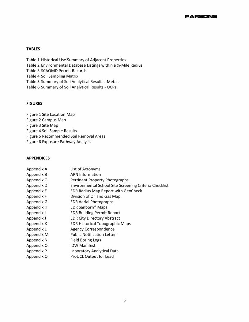
TABLES Table 1 Historical Use Summary of Adjacent Properties Table 2 Environmental Database Listings within a ½‐Mile Radius Table 3 SCAQMD Permit Records Table 4 Soil Sampling Matrix Table 5 Summary of Soil Analytical Results ‐ Metals Table 6 Summary of Soil Analytical Results ‐ OCPs FIGURES Figure 1 Site Location Map Figure 2 Campus Map Figure 3 Site Map Figure 4 Soil Sample Results Figure 5 Recommended Soil Removal Areas Figure 6 Exposure Pathway Analysis APPENDICES Appendix A List of Acronyms Appendix B APN Information Appendix C Pertinent Property Photographs Appendix D Environmental School Site Screening Criteria Checklist Appendix E EDR Radius Map Report with GeoCheck Appendix F Division of Oil and Gas Map Appendix G EDR Aerial Photographs Appendix H EDR Sanborn® Maps Appendix I EDR Building Permit Report Appendix J EDR City Directory Abstract Appendix K EDR Historical Topographic Maps Appendix L Agency Correspondence Appendix M Public Notification Letter Appendix N Field Boring Logs Appendix O IDW Manifest Appendix P Laboratory Analytical Data Appendix Q ProUCL Output for Lead
Parsons
7
EXECUTIVE SUMMARY
Los Angeles Unified School District’s (LAUSD) 93rd Street Elementary School campus (the Campus) is
located at 330 East 93rd Street, Los Angeles, CA 90003. The Campus is bounded by 93rd Street to the
north, Towne Avenue to the east, 95th Street to the south, and an alley to the west. Residential and
commercial properties facing South San Pedro Street are located west of the alley (Figure 1). The
School property is currently an active school site. The Campus consists of existing school buildings
and playground areas. The Campus is on one parcel that is approximately 6.44 acres (Figure 2). The
Preliminary Environmental Assessment Equivalent (PEAE) contained in this document focuses on a
portion of the Campus scheduled for redevelopment (Site). The Site is approximately 1.7 acres
within the Campus footprint, encompassing the existing auditorium, kitchen, lunch pergola, and
northwestern portion of the playground (Figure 3). Off‐Site locations may be within the Campus but
outside of the Site, and Off‐Campus locations are outside of the Site and Campus.
The School property has the following assessor parcel number (APN), as designated by the Los
Angeles County Office of the Assessor:
6052‐023‐903
HISTORICAL SITE SUMMARY
Aerial Photographs, Sanborn® maps, and other historical documentation indicate that the 93rd
Street Elementary School property at 330 East 93rd Street, in Los Angeles, California was
undeveloped until the 1920’s, at which time the Campus appears to be under agricultural use
(starting in the early 1920’s). The property was initially used agriculturally, and residential
structures were constructed at the Site by 1928. The residential structures were removed in the
early 1960s, and the Campus was constructed in 1962. The adjacent properties have been primarily
residential from the early 1920’s through the present day (January 2016).
CURRENT SITE DESCRIPTION
The LAUSD 93rd Street Elementary School consists of single and multi‐story school‐use buildings
throughout the property located at 330 East 93rd Street in Los Angeles, California. The school
property also has asphalt‐paved play areas (primarily on the southern portion of the Site), and
areas landscaped with grass, trees and bushes. The front of the school faces north toward 93rd
Street.
The Site is a portion of the school property surrounding the auditorium, kitchen, lunch shelter, a
portion of the school garden and play areas, and the southwestern parking area currently covered
with concrete, asphaltic concrete (AC) pavement, and grass.
There are residential dwellings across the streets to the north and south, and across an alley to the
west and in the neighborhood surrounding the Site. The school borders the Site to the east.
RECOGNIZED ENVIRONMENTAL CONDITIONS (RECs)
Available information for the Site and surroundings was collected and evaluated to identify
Recognized Environmental Conditions. According to the American Society for Testing and Materials
(ASTM) Standard Practice E 1527‐13, the term Recognized Environmental Conditions (RECs) means
Parsons
8
“the presence or likely presence of hazardous substances or petroleum products in, on or at a
property due to release to the environment under conditions indicative of a release to the
environment; or under conditions that pose a material threat of future release to the environment.
De minimis conditions are not recognized environmental conditions.”
Parsons completed research for the purpose of identifying potential RECs and Controlled RECs
(CRECs, those that may be present, but are managed in place) at the Site. The PEAE revealed
evidence of the following on‐Site and off‐Site, and off‐campus, RECs and CRECs:
On‐Site RECs Findings:
1. Potential presence of lead‐based paint residues and termiticides associated with
former residential structures and current school buildings.
2. Potential presence of pesticides associated with areas of the Site that were former
agricultural use.
3. Potential presence of arsenic underneath the pavement that may have been
applied as an herbicide (former LAUSD standard practice).
4. Potential presence of refrigerants in the walk‐in refrigerator located south of the
kitchen.
Off‐Site/Off‐Campus RECs Findings:
1. 9324 San Pedro Street was evaluated as a potential off‐site REC due to a structure
labeled “GAS & OIL” on the Sanborn® Maps. However, the physical distance from
the Site, a culvert located in the alley between the two properties, depth to
groundwater, and prevailing groundwater gradient make it unlikely that a release
from this structure would have impacted the Site.
On‐Site CRECs Findings:
2. The documented presence of asbestos‐containing materials (ACM) in various
buildings around the school. The ACM is currently managed in place per LAUSD’s
Asbestos Management Plan, which are included in Campus documents.
On‐Site REC Recommendations:
1. Surface and shallow soils at biased and unbiased locations on the Site be sampled
and analyzed for the potential presence of elevated lead due to historical lead‐
based paint use in buildings that previously existed in the area of the proposed
development.
2. Surface and shallow soils at biased and unbiased locations on the Site be sampled
and analyzed for the potential presence of organochlorine pesticides from
termiticides due to former buildings in the area of the proposed development.
3. Due to former LAUSD practice, surface and shallow soils at unbiased locations
underneath paved areas of the Site should be sampled and analyzed for the
potential presence of arsenic.
Parsons
9
Off‐Site/Off‐Campus CRECs Recommendations:
1. Continue to manage the in‐place ACM, with documentation.
WORKPLAN FOR SOIL SAMPLING
Based on the RECs described above Parsons prepared a Workplan for Soil Sampling (Parsons, 2015). The objective of the proposed sampling was to determine whether elevated concentrations of the following are present in shallow soil:
Pesticides
Lead
Arsenic
SITE_SPECIFIC CLEANUP GOALS
Site‐Specific Cleanup Goals (SSCGs) were developed with consideration for 1) naturally occurring
background levels (12 milligrams per kilogram [mg/kg] arsenic in soil), 2) levels established by
regulatory agencies for lead (a 95% Upper Confidence Limit (UCL) less than 80 mg/kg in soil), 3)
residential regional screening levels (RSLs) for pesticides), and 4) State and Federal definitions of
hazardous materials.
RESULTS OF SOIL SAMPLING
The results of the soil sampling determined the following:
Pesticides – The single pesticide detected (17 microgram per kilogram (μg/kg) of 4,4’ ‐DDE)
was well below the residential RSL of 400 μg/kg.
The 95% upper confidence limit (UCL) for lead was below the SSCG.
Lead concentrations detected at a single location exceed the soluble threshold limit
concentration (STLC) of 5 milligrams per liter (mg/L). Thus the soil at this location is defined
as hazardous in the state of California. However, the lead in the sample is not considered
hazardous by the federal Resource Conservation Recovery Act (RCRA) standard.
Non‐hazardous concentrations of arsenic above expected naturally occurring background
levels were detected in the upper 6‐inches of several borings located adjacent to each
other.
FINDINGS AND RECOMMENDATIONS
Based on the results of the soil sampling, the following findings and recommendations concerning the Site can be made:
Pesticides do not warrant further investigation or removal action.
Due to localized concentrations of non‐RCRA hazardous concentrations of lead near boring
C4, the excavation and lawful offsite disposal of approximately 6 cubic yards (9 tons) of
material to a depth of 2.5 feet is recommended.
Parsons
10
Due to concentrations of arsenic above SSCGs detected near boring B4 the excavation and
lawful offsite disposal of approximately 120 cubic yards (190 tons) of material to a depth of
12 inches is recommended.
Parsons
11
1.0 INTRODUCTION
1.1 Objective
Parsons conducted a Preliminary Environmental Assessment Equivalent (PEAE) for the purpose of
identifying potential Recognized Environmental Conditions (RECs) at the following location: 330
East 93rd Street in Los Angeles, CA 90003. The Campus is bounded by 93rd Street to the north,
Towne Avenue to the east, 95th Street to the south, and an alley to the west. Residential properties
facing South San Pedro Street are located west of the alley (Figure 1).
The term REC as defined in the American Society for Testing and Materials (ASTM) Standard
Practice E 1527‐13, means the presence or likely presence of any hazardous substances or
petroleum products in, on, or at a property; (1) due to any release to the environment; (2) under
conditions indicative of a release to the environment; or (3) under conditions that pose a material
threat of a future release to the environment. REC includes hazardous substances or petroleum
products even under conditions in compliance with applicable laws. REC is not intended to include
de minimis conditions that generally would not be the subject of an enforcement action if brought
to the attention of appropriate governmental agencies. A list of acronyms is presented as
Appendix A.
A second purpose of this investigation was to acquire information regarding safety issues that may
be of specific interest to the LAUSD, including geologic hazards and the proximity of the Site to
potentially hazardous activities (e.g., fuel pipelines, airports, railroads, high voltage power
transmission lines, major roadways, etc).
1.2 Scope of Services
Parsons performed the following tasks:
1.2.1 Records Review:
Review available current and historical documents, including agency records, pertinent to
environmental activities conducted at or near the Site. Topics of interest include chemical usage or
inventories, waste management records, Resource Conservation and Recovery Act (RCRA) or
Comprehensive Environmental Response Compensation and Liability Act (CERCLA) activities, and
health and safety operations.
1.2.2 Site Reconnaissance and Interviews:
Perform reconnaissance of the Site to visually and physically observe and document conditions on
the property. Interview knowledgeable site personnel regarding potential storage or use of
hazardous materials, both past and present.
1.2.3 File Search and Records Review:
Perform search of Federal, state and local regulatory agency electronic databases. This database
search identifies locations that are regulated under various environmental laws, notably CERCLA,
RCRA, and the Toxic Substances Control Act (TSCA). It also identifies locations where a release of
hazardous substances has occurred or is suspected.
Parsons
12
1.2.4 Permit and Agency File Review:
Review permits and documentation on file with regulatory agencies.
1.2.5 Historical Maps and Photographs Review:
Review available historical aerial photographs, topographic maps, fire insurance maps, and City
Directories to identify locations of activities that may pose an environmental concern to the School
campus.
1.2.6 School Suitability Evaluation:
Acquire information regarding safety issues that are of specific interest to the LAUSD, including
geologic hazards and the proximity of the School campus to potentially hazardous activities (e.g.,
fuel pipelines, airports, railroads, high voltage power transmission lines, major roadways, etc.).
1.2.7 Planning:
Prepare a Workplan for Soil Sampling (Parsons, 2015). The objective of the proposed sampling was to determine if any RECs present within the Site were present in concentrations that pose a threat to human health or the environment.
1.2.8 Soil Sampling and Analyses:
Complete the sampling and analyses as described in the Workplan for Soil Sampling.
1.2.9 Evaluate Data and Prepare Report:
Summarize significant findings from the above‐stated tasks and make recommendations for
additional activities, if needed.
Parsons
13
2.0 PROPERTY DESCRIPTION
2.1 Location and Legal Description
The Campus is located at 330 East 93rd Street in Los Angeles, California, 90003. Residential
properties are adjacent on all four sides of the Campus, and a commercial property is located at the
corner of 93rd Street and San Pedro Street to the northwest. Residential structures comprise the
primary land use in the local vicinity of the School campus. The subject PEAE Site is bounded by
school property immediately adjacent to the east, south and north sides, and an alley to the west.
The School property has the following assessor parcel number (APN), as designated by the Los
Angeles County Office of the Assessor: 6052‐023‐903. A copy of the APN map for the Site is
provided in Appendix B.
2.2 Description of Property Structure(s) and Other Features
LAUSD owns the single parcel that is bound by 93rd Street, Towne Avenue, 95th Street, and an alley
parallel to South San Pedro Street. The Campus consists of single and multi‐story school buildings,
and paved and unpaved areas for playground and parking uses. The portion of the Campus that
includes the Site currently has one building, two vehicle parking areas, and several portable storage
containers, and an outdoor walk‐in refrigerator (in October 2015).
2.3 Current Uses of the Property
2.3.1 Methodology
On October 20, 2015, Parsons’ personnel performed reconnaissance at the Campus. The
methodology involved a walkthrough of the Site and areas adjacent to the Site, noting observations
and taking photographs of notable features. Observations are presented in Section 5.0. The
methodology also included reviews of regulatory files and historical resource records. A Site Map is
provided as Figure 3. Pertinent Campus, Site and adjacent property photographs are provided in
Appendix C. The Environmental School Site Selection Screening Criteria Checklist is included as
Appendix D.
2.3.2 Current Uses of the Property
The Campus is currently a fully operational school administered by the LAUSD. The Site includes
one building, one lunch shelter, a portion of two vehicle parking areas, several portable storage
containers, an outdoor walk‐in refrigerator, and a portion of a paved play yard.
2.4 Current Uses of Adjacent Properties
Based on observations during the School campus assessment, and information found in the
Environmental Data Resources, Inc. (EDR) radius search (Appendix E), the School campus is
bordered by the following:
North: 93rd Street is present directly north of the School campus. North of 93rd Street are single
and multi‐family residential dwellings.
Parsons
14
East: The Campus is bounded to the east by Towne Avenue. East of Towne Avenue are single‐family
residential dwellings.
South: The Campus is bounded to the south by 95th Street. South of 95th Street are single and
multi‐family residential dwellings.
West: The Campus is bounded to the west by an alley, across the alley are single and multi‐family
residential dwellings and a few commercial properties.
2.5 Topographic Setting
According to the 2012 United States Geological Survey (USGS) Inglewood and 2012 South Gate
Quadrangles, the center of the Site has an approximate Latitude (North) of 33° 57’ 3.96” and
Longitude (West) of ‐118° 16’ 7.32“. The Campus elevation is on average approximately 125 feet
above mean sea level. The surface topography at the Campus (and Site) is essentially flat but slopes
gently south‐southeast.
2.5.1 Nearest Surface Water Body
The nearest surface water body to the Site is the concrete lined channel of Compton Creek located
approximately 0.8 miles south. Compton Creek drains to the southeast and is a tributary of the Los
Angeles River (USGS, 2012a, 2012b).
2.6 Regional Geology
The Site is located in the central block of the Los Angeles Basin between the Newport‐Inglewood
Fault to the southwest and the Whittier Fault Zone to the northeast. The Campus is underlain by
recent alluvial sediments consisting primarily of silt, sand, and gravel deposited by the Los Angeles
River (CDWR, 1961).
2.6.1 Special Studies Zones
The Campus is not within Earthquake Fault Zone Area or Fault Rupture Study Area. Additionally,
the City of Los Angeles Planning Department’s Zone Information and Map Access System (ZIMAS)
interactive mapping tool (http://zimas.lacity.org), indicates the nearest fault is the Newport
Inglewood Fault located approximately 2.0 miles from the Site (ZIMAS, 2015).
2.6.2 Potential for Liquefaction and Landslides
The Campus does not fall within an identified Alquist‐Priolo Zone, according to the State of
California Seismic Hazard Zone Inglewood Quadrangle map (DMG, 1999). The Campus is located
within an identified potential liquefaction zone. These zones are classified as “areas where historic
occurrence of liquefaction, or local geological, geotechnical and groundwater conditions indicate a
potential for permanent ground displacements such that mitigation as defined in Public Resources
Code Section 2693c would be required.” The closest recognized potential for landslide is more than
three miles east of the Campus.
Parsons
15
2.6.3 Radon
The California Geologic Survey’s Radon Potential Zone Map (prepared for the California
Department of Health Services, Environmental Health Division, for Southern Los Angeles County
dated January 2005) indicates the Campus is within an area estimated to have low potential for
indoor radon levels above 4.0 Picocuries per liter (P/L). Radon information for Los Angeles County
indicates that the United States Environmental Protection Agency (USEPA) has categorized Los
Angeles County as Zone 2 for radon. A Zone 2 classification is for areas with indoor average radon
levels of greater than or equal to 2 P/L), but less than or equal to 4 P/L. The USEPA radon
recommended action level is 4 P/L.
2.6.4 Methane
According to the City of Los Angeles Planning Department’s ZIMAS interactive mapping tool
(http://zimas.lacity.org), the Campus is not identified as a Methane Hazard Site (LACPD, 2015). Also,
the Campus is not located in a Methane Zone or Methane Buffer Zone (Appendix F).
2.6.5 Potential for Flooding
The Campus is not located within a designated 100‐year or 500‐year flood plain as designated by
information provided by EDR (Appendix E). The Federal Emergency Management Agency maintains
a flood insurance rate map, which indicates that the Site does not fall within a 100‐year or 500‐year
flood plain (FEMA, 2008).
2.6.6 Oil Fields and Wells
A review of the State of California Department of Conservation, Division of Oil, Gas and Geothermal
Resources (DOGGR) oil well tracking maps did not identify any oil wells or natural gas fields located
on or adjacent to the Campus. No known oil wells are located onsite or adjacent to the Campus per
State of California Department of Conservation Division of Oil, Gas, and Geothermal Resources
Online Mapping System. There were no wells identified by EDR (Appendix E) within one mile of the
Site. Additionally, according to the Oil Wells, Oil Fields and Landfill Sites Map produced by the City
of Los Angeles, Bureau of Engineering, the Campus is not within a productive boundary of an oil
field. The nearest oil field boundary is the Howard Townsite oil field approximately two miles south
of the Campus (Appendix F).
2.7 Regional Hydrogeology
The Los Angeles Coastal Plain is divided into four groundwater basins; the Santa Monica Basin, The
West Coast Basin, the Hollywood Basin, and the Central Basin. The Campus lies within the Central
Subbasin. The principal aquifers beneath the Campus are the Gage, Lynwood, Silverado and
Sunnyside Aquifers. The Gage Aquifer is located within the Lakewood formation, The Lynwood,
Silverado, and Sunnyside aquifers are within the San Pedro Formation (CDWR, 1961).
2.7.1 Groundwater Wells within a 1‐Mile Radius of the School Campus
According to the Los Angeles County Department of Public Works Hydrologic Records Division
website (http://dpw.lacounty.gov/general/wells) there are three active wells located within a 1‐
mile radius of the Campus (LADPW, 2015). One well is located approximately 0.5 miles to the north
Parsons
16
of the Campus, near the intersection of Manchester Avenue and San Pedro Street. This is State Well
ID 1434J, and depth to water was last measured at 171.40 feet below ground surface (ft bgs) on
January 6, 2010. Two other wells are located approximately 0.75 miles southeast of the Site. These
wells are State Well IDs 1145F and 1145Q. Depth to water in these wells is reported as 183.30 ft bgs
on March 4, 2008 and 197.70 ft bgs on January 6, 2010. Only limited information was available for
these wells. The nearest groundwater monitoring well to the Campus as found on the State Water
Resources Control Board’s Geotracker website is approximately one‐half mile southwest of the
Campus. The monitoring wells were installed as part of an open Leaking Underground Storage Tank
case (Global ID # T0603700411, RWQCB case # 900030034) at the Arco service station located at
105 Century Boulevard in Los Angeles. Depth to water, last measured in April 2015 in the wells on
that property, ranged from approximately 59 to 104 feet below grade. Additionally, in Geotracker
there is a School Clean Up Site (WDR File # 09‐134) at 8800 South San Pedro Street approximately
½‐mile north of the Campus. Depth to water in the site’s groundwater monitoring wells was
approximately 82 to 85 ft bgs.
2.7.2 Nearest Groundwater Production Well
According to the EDR Radius Report, there is one public water well within a one‐mile of the Site.
This well (02S/13W‐32R16 S) is owned by the City of Los Angeles Department of Water and Power,
and is located approximately 0.66 miles east‐southeast of the Site. EDR also identified four wells
maintained by the USGS California Water Science Center. These wells are located between 0.66 and
0.87 miles southeast to south of the Site. EDR searched the Federal USGS, Federal Reporting
Database System (FRDS) Public Water Supply and State databases (Appendix E).
Parsons
17
3.0 HISTORICAL REVIEW
3.1 Aerial Photograph Review
A review of historical aerial photographs obtained from EDR, dated 1923 through 2012 (Appendix
G), was performed.
The 1923 photograph depicts the Site as occupied with agricultural use and undeveloped land.
There are no structures on the Site. The land north, east, south, and west of the Site appears to be
developed for agricultural use. There are several small structures near the intersection of 93rd
Street and San Pedro Street. The adjacent and nearby properties appear to be agricultural use or
undeveloped vacant lots, with some residential‐type properties to the south and southwest. San
Pedro Street is established, and 93rd Street appears to be an unpaved road separating two fields.
The onsite features in the 1928 photograph show the Site and properties adjacent to the north,
east, and south have been developed as residential properties. Properties adjacent to the west
appear to be multi‐unit residential or commercial facing San Pedro Street. There are four residential
structures located on the south side of 93rd Street, and five residential structures on the north side
of 93rd Street. The streets surrounding the Site are now established, and 94th Street trends east /
west through the Site.
In the 1938 photograph the Site continues to be occupied by residences. Properties to the west
appear to be multi‐unit residential.
In the 1947 photograph the Site continues to be occupied by residences. An additional residential
structure is now present on the south side of 93rd Street. This is the first photograph that depicts
the neighborhood in the vicinity of the Campus as completely developed.
The 1952 photograph depicts the Site still occupied by residences. Additional development of
properties facing San Pedro has occurred.
The 1963 photograph is the first photograph showing the presence of a school on the subject
property. The school buildings and structures are primarily present on the northern half and along
the eastern side of the Campus. The remainder of the Campus appears to be a paved play area.
94th Street no longer trends through the Site; the school Campus extends from 93rd street to 95th
Street. Three large structures connected by covered walkways or adjoining roofs are located in the
northern portion of the Site. Four smaller structures are located along the eastern edge of the
school property. The properties in the immediate vicinity of the Campus appear to be residential
dwellings.
The 1970 photograph is the first to depict the addition to the Auditorium building in which the
kitchen is currently located. The four small structures located along the eastern edge of the school
property were removed, and replaced by one large structure. The remainder of the Campus is
similar to the 1963 school layout; the four buildings in the southeastern quadrant of the school
were replaced by one larger structure.
The 1972 photograph displays the Campus as similar to the 1970 school layout.
The 1981 photograph is similar to the 1972 photograph for the Campus.
Parsons
18
The 1989 photograph is essentially consistent with the 1981 photograph, with almost no change to
the Campus. The 1989 photograph resolution does not allow for observing much detail.
The 1994 photograph is essentially consistent with the 1989 photograph. Three small outbuildings
were added along the southern side of the Site along 95th Street, two in the southwestern portion
of the Campus, and one in the southeastern portion of the Campus. There appear to be cars or
other small structures lined up approximately where 94th Street used to pass through the Site. This
may be indicative of a parking area.
The 2002 photograph is generally similar to the 1994 photograph. There are three additional
structures in the southeastern corner of the Campus. A long rectangular structure, potentially a
shipping container is located near the western edge of the Site near where the historical southern
side of 94th Street used to be. The 2002 photograph resolution does not allow for observing much
detail.
The 2005 photograph is generally similar to the 2002 photograph, but there are three additional
rectangular structures, each approximately the size of a shipping container, in the southeastern
corner of the Campus.
The 2009 photograph is generally similar to the 2005 photograph. Two of the shipping container
sized structures in the southeastern corner of the site have been removed. The layout of the school
buildings is generally identical.
The 2010 photograph is essentially consistent with the 2009 photograph, with almost no change to
the Site.
The 2012 photograph is essentially consistent with the 2010 photograph, with almost no change to
the Campus.
3.2 Sanborn® Map Review
A review of Sanborn® maps obtained from EDR from between 1927 through 1969 (Appendix H) was
performed. The earliest Sanborn® map is dated 1927 and shows the Site as developed with
residential properties, with 94th Street bisecting the Site from east to west and alleys located
midway between E 93rd Street and E 94th Street and E 94th Street and E 95th Street (also east to
west). There are rectangular lots (several of the lots are residentially developed). There are seven
residential structures and eight out‐building structures included on the 1927 Sanborn® map. Many
properties in the Site vicinity are not developed.
The Sanborn® map dated 1950 indicates that the orientation of streets is the same as in the 1927
Sanborn® map. Most of the rectangular lots in the Site vicinity are developed. Nine residential
structures and nine out‐buildings, including two new dwellings and a new outbuilding are depicted
within the Site boundary.
The Sanborn® map dated 1969 indicates that the residential structures and 94th Street have been
redeveloped into a school campus. The auditorium building is located in the same footprint that the
auditorium building occupies in 2016. The “KITCHEN” is depicted within the same building as the
auditorium immediately behind the “STAGE”. There is no structure occupying the area where the
kitchen is located today. The “LUNCH SHELTER” is depicted south of the auditorium. The school
Parsons
19
property is named “Ninety Third St. School”. A number of the school structures are labeled and are
generally indicated on the map to have been constructed in 1962. There are classroom buildings
east of the Site occupying the northeastern quadrant of the Campus. Residential dwellings are
present across the streets from the Site to the north, east and south, and a mix of residential and
commercial properties to the west.
All of the Sanborn® maps illustrate a rectangle labeled “GAS & OIL” within 9324 S San Pedro. This
property currently operates as a tire repair shop.
3.3 Sewer Permit Review
No sewer permits were listed on the City of Los Angeles Department of Public Works Bureau of
Engineering Navigate LA website. The Campus property currently is connected to the local sewer,
according to Mr. Maciel, the Campus Plant Manager. Sewers are present along the streets adjacent
to the subject Campus. No sewer permits were documented for the Site in the EDR Building Permit
Report (Appendix I).
3.4 City Directory and Environmental Lien Review
The City Directory Abstract (Appendix J) was reviewed, and records indicate that the address
occupied by Mrs. Frances Powers in 1958 and that the occupancy changed to 93rd Street
Elementary School by 1967. Surrounding properties appear to be primarily residential. Several
commercial properties have operated west of the alley on the west side of the Campus. One
property (9324 South San Pedro Boulevard) was historically operated as a Service station, and
currently operates as a tire repair shop. Given the large number of parcels (48) that previously
made up the Campus, and in conjunction with discussions with the LAUSD project manager a
review of the Environmental Lien records was not conducted.
3.5 Historical Topographic Map Review
A review of historical topographic maps from 1896 to 1981 was conducted (Appendix K).
The 1896 topographic map shows the Site and surrounding vicinity of the Site as being
undeveloped land. Very few streets are present in the vicinity of the Site and many streets are not
identified. An unidentified rail line is depicted trending north/south approximately 0.7 miles west of
the subject Site, and an Atchison Topeka and Santa Fe Railroad line with tracks trending east/west
over one mile to the north. The 1901 topographic map depicts the entire Los Angeles Basin, and
does not include details about the immediate Site vicinity.
The 1924 topographic map shows the Campus subject property as vacant and undeveloped land;
similar to the surrounding properties. Some of the land in the vicinity of the Site appears to be
more developed with streets and blocks present.
The 1937 topographic map shows the subject property as partially developed with streets adjacent
to all sides of the block which has the Site. Century Boulevard is identified south of the Site, and
Avalon Boulevard and Broadway are identified east and west of the Site.
Parsons
20
The 1948 topographic map identifies “OIL TANKS” approximately 2.3 miles to the south‐southeast
of the Site. There are no details included regarding what structures exist at the Site and
surrounding vicinity.
The 1950 topographic map shows the Site and surrounding land highly developed and very similar
to the property and street layout today in 1948.
The 1964 topographic map depicts the Campus as a school for the first time. 94th Street has been
removed from the Campus property. The auditorium building without the kitchen addition, the
Administration building, and the classrooms in the northeastern quadrant are depicted on the
Campus along with small out‐buildings in the southeast quadrant of the Campus. The Harbor (110)
Freeway is depicted for the first time west of the Site.
The 1972 topographic map depicts the Site similarly to the 1964 map, except the buildings in the
southeast quadrant have been replaced by one larger classroom building along the eastern edge of
the Campus, and the lunch shade structure is included for the first time.
The 1981 topographic map is consistent with the 1972 (no observable change to the Site and
adjacent properties) and the historical photographs for those approximate time frames.
3.6 Historical Uses and Operations of the Property
Historical aerial photos, Sanborn® maps and topographic maps suggest that the Site and Campus
were undeveloped from an unknown period (starting in 1896 ‐ the earliest record reviewed for this
report, and shown as undeveloped on maps) until the first evidence of agricultural use (1923 aerial
photograph). The agricultural use was present for the entire Site property including the adjacent
school property to the south, east, and north. The adjacent (across the street from the Site) lots are
primarily residentially developed lots, with some commercial properties facing San Pedro Street.
Records indicate the school construction initially began by about 1962. The property has been
developed as a school since 1962 through the present time in early 2016. All of the adjacent
properties have maintained similar use for many decades. The properties adjacent and across the
streets from the Site have been residential dwellings or commercial properties since initial
development.
3.6.1 Agricultural Use of the Property
Review of historical documents (primarily historical aerial photographs) for this report indicates the
subject school property was used for agricultural purposes between at least approximately 1923
and prior to 1927. No information regarding the use, storage, disposal, etc. of chemicals related to
the above‐described previous agricultural uses was gathered or reviewed during the preparation of
this PEAE. There is currently a garden maintained in above‐ground planters by the Campus faculty
at the eastern edge of the Site. According to Mr. Maciel, the Campus Plant Manager, no pesticides
or herbicides are used in this garden.
3.6.2 Property Use by the Federal Government
No uses of the Campus by the Federal Government were identified.
Parsons
21
3.6.3 Historical Landmarks on the Property
No historical landmarks were identified to exist on the Campus.
3.6.4 Prior Assessment Reports
LAUSD has indicated they do not have any previous assessment reports on file.
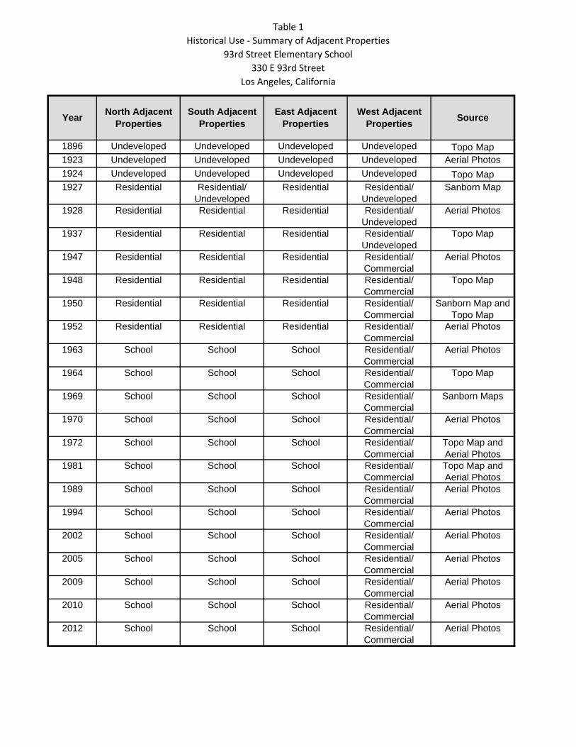
3.6.5 Historical Use Summary on Adjacent Properties
Based on the historical information reviewed by Parsons, Table 1 provides a summary of the
development of the properties adjacent to the Site.
Parsons
22
4.0 REGULATORY AGENCY INFORMATION
4.1 Property Permits
4.1.1 Current Property Permits
Based on the building permit records obtained from the City of Los Angeles Department of Building
and Safety and reviewed, the Site at 330 East 93rd Street was permitted for construction as a
school in 1961.
4.1.2 Noncompliance and Permit Violations
Based on the EDR database review and requests for information from relevant regulatory agencies,
no records were identified regarding environmental noncompliance or permit violations for the
Campus.
4.1.3 Property Listings with Regulatory Agencies
A request for information was sent to regulatory agencies to obtain information regarding current
or historical occupants and uses of the Campus. Section 4.2 below provides information for
properties that have been or that may be currently listed with Regulatory Agencies, as identified in
the EDR Radius Report (EDR, 2015). Section 4.3 provides information obtained directly from the
regulatory agencies.
4.2 Regulatory Database Search
Parsons retained the services of EDR, an environmental database research company, to search
applicable regulatory agency lists and standard environmental record sources to identify locations
of potential concern within the ASTM Standard Practice E 1527‐13 minimum search distances. The
following is a summary of the environmental database report, dated September 17, 2015. The
complete environmental data report is presented in Appendix E. The report includes maps with
concentric circles indicating the ASTM database search distances of 1/4, 1/2, and 1 mile. A search of
the respective environmental databases indicated 42 properties within the ASTM‐prescribed
minimum search distances.
Table 2 presents a summary of identified properties at and within ½ mile of the Site. The table
identifies facilities/properties; approximate distance, direction, and environmental concern/status
(if available).
There are five sites that were not mapped by EDR due to poor or inadequate address information.
They are the following:
Alley way at 9501 Hickory Street
Alley Between 606 and 616 107th Street
Alley behind 9217 Laurel Street
South Central Los Angeles Discovery Project
Chandler Lease Property
Parsons
23
None of the above five sites were observed adjacent or in the nearby vicinity of the Site during the
Site reconnaissance on October 20, 2015.
4.3 Additional Regulatory Agency Record Sources
4.3.1 South Coast Air Quality Management District
The South Coast Air Quality Management District (SCAQMD) was contacted for information
regarding the following record types:
Applications
Permits to Operate
Equipment List Report
Notices of Violation
Notices to Comply
Complaints
Site Inspection Reports
Emissions Summary
Source Test Reports
Air Monitoring Data
Asbestos Notifications / Records
Facility Potential to Emit
Facility Positive Balance
Toxic Health Risk Assessment
The records provided by the SCAQMD for the subject school property were reviewed and are
summarized in Table 3. Copies of the records provided are included in Appendix L.
4.3.2 Los Angeles Regional Water Quality Control Board
Records were requested from the Los Angeles Regional Water Quality Control Board (RWQCB)
Underground Storage Tank (UST) and Spills, Leaks, Investigations, and Cleanups Divisions for
hazardous waste cleanups and operations related to the subject Site. The RWQCB indicated in their
response dated October 26, 2015 that no records were found (Appendix L).
4.3.3 City of Los Angeles, Bureau of Sanitation – Industrial Waste Management Division
Records were requested from the City of Los Angeles, Bureau of Sanitation. Their response
(Appendix L) indicates no citations have been issued for the past five years. A permit for discharge
from the school kitchen was last amended in February 2006. The discharge is made from the Site
to the public sewer. An 8‐inch concrete sewer pipe was connected to the public sewer, with a total
discharge flow of 100 gallons per day allowance.
Parsons
24
4.3.4 Los Angeles County, Department of Sanitation – Industrial Waste Division
Records were requested from the Los Angeles County Department of Sanitation (LACDS) regarding
notices of violation (NOVs), discharges, hazardous materials, chemicals or waste spills and/or site
remediation. The LACDS indicated in their response the Site is not within their jurisdiction
(Appendix L).
4.3.5 Los Angeles County, Department of Public Health
Records were requested from the County of Los Angeles Department of Health Services (DHS)
Public Health for hazmat business plans, chemical inventories, hazardous waste spills, or
remediation. The Department of Public Health has indicated (see Appendix L) no Land Use
(Septics), Solid Waste (Landfills), or Hazardous Materials Emergency or emergency response
records were found that were related to the subject school property (Appendix L).
4.3.6 State of California Department of Toxic Substances Control
The Cypress and Chatsworth offices of the Department of Toxic Substances Control (DTSC) were
contacted concerning possible hazardous waste use, assessments, investigations, cleanups and
operations for the subject Site (Appendix K). No records were found in the DTSC online database
(EnviroStor, 2015).
4.3.7 State of California Department of Conservation, Division of Oil, Gas and Geothermal
Resources
A review of the State of California Department of Conservation Division of Oil, Gas, and Geothermal
Resources Online Mapping System (DOGGR, 2015) oil well tracking maps did not identify any oil
wells or natural gas fields located on or adjacent to the Site. No known oil wells are located onsite
or adjacent to the Site per DOGGR’s Online Mapping System (DOGGR, 2015). The nearest wells
identified by EDR (Appendix E) are over one mile to the South. Additionally, according to the Oil
Wells, Oil Fields and Landfill Sites Map produced by the City of Los Angeles, Bureau of Engineering,
indicate the Site is not within a productive boundary of an oil field. The nearest oil field boundary is
the Howard Townsite oil field approximately two miles south of the Campus (Appendix F).
4.3.8 City of Los Angeles Fire Department: Underground Tank Unit
The Underground Tank Unit of the City of Los Angeles Fire Department was contacted regarding
USTs for the Site. The City Fire Department indicated they do not maintain fire prevention records
for the subject Campus (Appendix L).
4.3.9 Office of the State Fire Marshal: Pipeline Safety Division
The Office of the State Fire Marshal (OSFM): Pipeline Safety Division was contacted concerning
possible hazardous materials pipelines located within 1,500 feet of the Site. The OSFM response
(Appendix L) indicated there are no pipelines jurisdictional to the State Fire Marshal within the
search radius.
Parsons
25
4.3.10 City of Los Angeles Department of Water and Power
The City of Los Angeles Department of Water and Power (LADWP) was contacted regarding the
presence and status of transformers located at or in the vicinity of the Site. During a file review
records provided by LACDWP indicate the only transformer on the subject property is IS‐0736‐01.
It has a 750 kilovolt line that feeds power to the school. The transformer was reportedly tested for
PCBs in 1999, and PCBs were not detected to a reporting limit of 2 parts per million (Appendix L).
Parsons
26
5.0 PROPERTY CONDITION
5.1 Site Reconnaissance and Interviews
On October 20, 2015, Parsons personnel performed a reconnaissance at the 93rd Street Elementary
School campus, including the Site. The reconnaissance involved a walk‐through of the Campus,
noting observations, taking photographs of notable features, and interviewing LAUSD personnel
who have knowledge of current and historical uses of the Campus. The purpose of the
reconnaissance was to obtain information which may indicate the likelihood of identifying RECs in
connection with the subject Site. LAUSD employee Mr. Norberto Maciel, the Campus Plant
Manager, was interviewed onsite during the reconnaissance. Mr. Maciel has been the Campus
Plant Manager at this school for approximately the past three years, and worked at the Campus for
the past six years. Photographs of the Site are located in Appendix C.
5.2 Hazardous Material Handling
5.2.1 Current and Past Hazardous Material Handling Practices
Chemicals and hazardous materials were observed to be present in de minimis quantities at several
locations around the school property. These primarily consisted of cleaning materials stored in
several locked rooms or small storage closets around the school. Small volumes (on the order of
gallons) of typical cleaning materials were noted, including gallon containers of liquid hand soap,
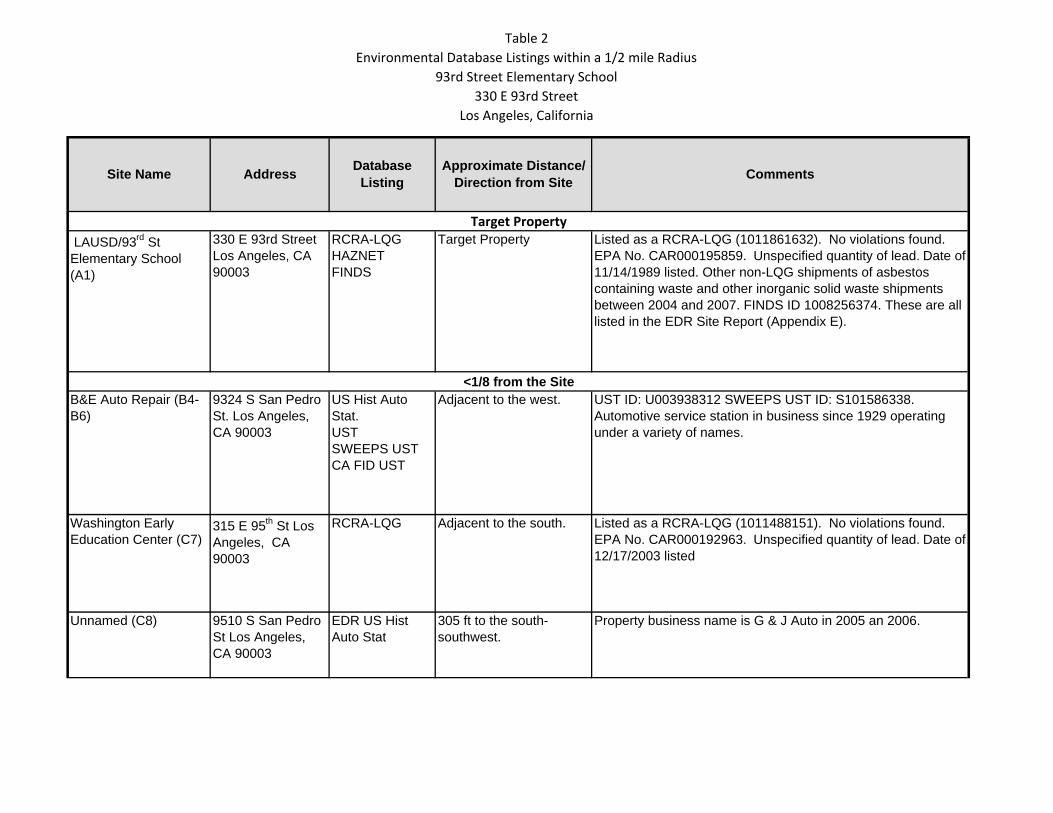
Environmental Database Listings within a 1/2 mile Radius
93rd Street Elementary School
330 E 93rd Street
Los Angeles, California
LAUSD/93rd St Elementary School (A1)
330 E 93rd StreetLos Angeles, CA 90003
RCRA-LQGHAZNETFINDS
Target Property Listed as a RCRA-LQG (1011861632). No violations found. EPA No. CAR000195859. Unspecified quantity of lead. Date of 11/14/1989 listed. Other non-LQG shipments of asbestos containing waste and other inorganic solid waste shipments between 2004 and 2007. FINDS ID 1008256374. These are all listed in the EDR Site Report (Appendix E).
B&E Auto Repair (B4-B6)
9324 S San Pedro St. Los Angeles, CA 90003
US Hist Auto Stat.USTSWEEPS USTCA FID UST
Adjacent to the west. UST ID: U003938312 SWEEPS UST ID: S101586338. Automotive service station in business since 1929 operating under a variety of names.
Washington Early Education Center (C7)
315 E 95th St Los Angeles, CA 90003
RCRA-LQG Adjacent to the south. Listed as a RCRA-LQG (1011488151). No violations found. EPA No. CAR000192963. Unspecified quantity of lead. Date of 12/17/2003 listed
Unnamed (C8) 9510 S San Pedro St Los Angeles, CA 90003
EDR US Hist Auto Stat
305 ft to the south-southwest.
Property business name is G & J Auto in 2005 an 2006.
Target Property
<1/8 from the Site
Site Name AddressDatabase
ListingApproximate Distance/
Direction from SiteComments
Table 2
Environmental Database Listings within a 1/2 mile Radius
93rd Street Elementary School
330 E 93rd Street
Los Angeles, California
Matheny E M MRS (9) 9210 S San Pedro St Los Angeles, CA 90003
EDR US Hist Cleaners
374 ft to the northwest. Property business name Matheny E M MRS in 1937.
Dream Master’s Automotive (D10-D12)
9602 S San Pedro St Los Angeles, CA 90003
EDR US Hist Auto Stat USTSWEEPS USTCA FID UST
609 ft to the south-southwest.
UST ID U004194954 SWEEPS UST S101586116Automotive service station 1942 through 2009 under various names.
Unnamed (D13) 9607 S San Pedro St Los Angeles, CA 90003
EDR US Hist Auto Stat
629 ft to the south-southwest.
Property business name Little Jim & Tim’s Auto Interior 1999, 2001, and 2002.
A and H Cleaners (D14)
9615 S San Pedro St Los Angeles, CA 90003
RCRA-SQGFINDSEMIHAZNET
653 ft to the south-southwest.
RCRA-SQG ID 1001481001EPA ID CAR000046854. Waste names PCE, halogenated solvents mixtures including PCE, methylene chloride, TCE, 1,1,1-TCA, chlorobenzene, 1,1,2-trichloro-1,2,2-trifluroethane, ortho-dichlorobenzene, trichlorofluromethane, and 1,1,2-TCA. No violations found.
Unnamed (D15) 9624 S San Pedro St Los Angeles, CA 90003
EDR US Hist Cleaners
681 ft to the south-southwest.
Property business name is Neighbor Coin Laundry, 2006 though 2010.
Unnamed (E16) 9111 S San Pedro St Los Angeles, CA 90003
EDR US Hist Auto Stat
752 ft to the north-northwest.
Property business name Munoz Transmission in 2010.
Roeder Auto Parts (E17)
9111 S San Pedro St Los Angeles, CA 90003
SWEEPS USTCA FID UST
752 ft to the north-northwest.
SWEEPS UST ID S101586202. No UST data available.
L&K Service (F18, F20)
9511 Avalon Blvd Los Angeles, CA 90003
USTSWEEPS USTCA FID UST
1,005 feet to the east-southeast.
UST ID U003940304 No UST data available.
1/8 to 1/4 Mile from Site
Table 2
Environmental Database Listings within a 1/2 mile Radius
93rd Street Elementary School
330 E 93rd Street
Los Angeles, California
Anthony Boosalis (F19) 9511 Avalon Blvd Los Angeles, CA 90003
LUST 1,005 feet to the east-southeast.
Fuel or gasoline leak reported in 2002. Assessment in progress. RWQCB Case 900030243, City of Los Angeles Case XS0000390.
Davis H D (F21) 9511 Avalon Blvd Los Angeles, CA 90003
EDR US Hist Auto Stat
1,005 feet to the east-southeast.
Year 1942: Type listed is “gasoline and oil service stations”. Years 1999 through 2003 Business name Los Angeles Body Shop.
Avalon Ice Cream & Candy Co (F22, F23)
9523 Avalon Blvd, Los Angeles CA 90003
LUSTSWEEPS USTCA FID UST
1,014 ft to the east-southeast.
Petroleum leak reported 1995, case in pre-closure 4Q 2015. RWQCB Case 900030261. City of Los Angeles Case 33997 SWEEPS ID S101587827 No UST data available.
Uknown (G24) 9200 Avalon Blvd. Los Angeles 90003
US Hist Auto Stat
1,082 ft to the east-northeast.
Years 1999 through 2012 business name Avalon Body Shop.
Bob’s Mobil Service KRN (H25 through H28)
9600 Avalon Blvd, Los Angeles 90003
UST, SWEEPS UST, CA FID UST, US Hist Auto Stat, HIST UST
1,138 ft to the east-southeast.
UST U003970957, SWEEPS UST S101617078, HIST UST U001560275. Active gasoline and service station with USTs. The property has operated as a “gasoline and oil service station” since 1929. No releases or violations found
Shockey Clyde/Superior Auto Detail (G29, G30)
9125 Avalon Blvd, Los Angeles, CA 90003
SWEEPS UST, CA FID UST, US Hist Auto Stat
1,198 ft to the northeast SWEEPS UST S101586818. Operated as a “gasoline and oil service station” since 1933 under a variety of names. No UST data available.
Unknown (G31) 9123 Avalon Blvd, Los Angeles CA 90003
US Hist Auto Stat
1,202 ft to the northeast 2004 operated as Import Body Repair. No other records available.
Unknown (32) 9109 Avalon Blvd, Los Angeles, CA 90003
US Hist Auto Stat
1,229 ft to the northeast Operated as Henry’s welding & Auto Parts from 2001 through 2005.
Angelicas Recycling (33)
608 E 89th Street, Los Angeles CA 90003
SWRCY 0.335 mi. to the northeast Recycling center operating beginning 2007. No violations found.
1/4 to 1/2 Mile from Site
Table 2
Environmental Database Listings within a 1/2 mile Radius
93rd Street Elementary School
330 E 93rd Street
Los Angeles, California
South Region ES #1 Site 5 (34)
West 90th
Street/South Main Street, Los Angeles CA 90003
ENVIROSTOR SCH
0.347 mi. to the northwest
ENVIROSTOR ID S107737378. Lead based paint and UST removal completed in 2007.
Mobil #18-EL4 (35) 105 Century Blvd W, Los Angeles, CA 90003
LUST, HIST CORTESE
0.459 mi. to the southwest
LUST: Gasoline leak discovered in 1987. case open and in corrective action phase. Global ID T0603700411.
South Region High School #12, Site 1 (36)
87th Street/S. Avalon Blvd, Los Angeles, CA 90003
ENVIROSTORSCHDEED
0.481 mi. to the north-northeast
ENVIROSTOR ID S108195973. COCs include Arsenic, PAHs, PCE, TCE, TPH, Lead, and Zinc.Site currently in corrective action phase.
W&C Metal Polishing & Plating (37)
735 E Manchester Ave, Los Angeles CA 90001
RCRA-SQGENVIROSTORFINDSHAZNET
0.72 mi. to the north-northeast
RCRA-SQG ID 1000105911ENVIROSTOR ID CAD980881403. Site was a RCRA-LQG in 1984 and had 1 violation for an unspecified infraction. Site was in compliance by 1/1/1986. The site stores liquids with pH less than 2 with metals, alkaline solution with pH greater than 12.5 without metals, aqueous solutions with pH between 2 and 12.5, liquids with nickel greater than 134 mg/L, metal sludge pH greater than 12.5, other inorganic solids, and off-specification aged or surplus organics.
Table 3
SCAQMD Permit Records
93rd Street Elementary School
330 E 93rd Street
Los Angeles, California
Facility and Address Permit Type/Description DateFacility Equip. List Report:
-Boilers operating in compliance at time of inspection, no permitrequired.-Registration for refrigeration unit required.
Notification of Demolition or Asbestos Removal for 210 sq ft of friable insulation and 40 sq ft of class I roof mastic on auditorium building.
3/28/2015
NC E19805 – AQMD requires replace/retrofit of two boilers or prove emission limits are met via source testing or boiler therm use.
5/3/2013
Facility Equip. List Report:
Boilers not operating at time of inspection.
Additional inspection on 10/17/13 indicates boilers were replaced.
NC E05968 – AQMD requires replace/retrofit of two boilers or prove emission limits are met via source testing or boiler therm use.
4/26/2013
Facility Equip. List Report:
- Boiler inspection. Boilers not operating in compliance.
Registration of Air Conditioning System 1/12/2012
Notification Report for R1403 Asbestos Removal, no description of material removed.
11/20/2009
Notification of Demolition or Asbestos Removal (#185770) for 3,500 sq ft of Class II mastic.
3/7/2008
Notification of Demolition or Asbestos Removal (#98989) for 31,674 sq ft of class I mastic/floor tiles on various buildings.
3/30/2005
Notification of Demolition or Asbestos Removal (#92031/91899) for 33,540 sq ft of friable fire proofing and 9,920 sq ft of class I mastic/floor tiles on various buildings.
12/10/2004
Notification Report for R1403 Asbestos Removal, no description of material removed.
8/6/2004
Notification Report for R1403 Asbestos Removal, no description of material removed.
3/10/2004
Air Quality Notification Report (during ACM removal) 4/2/2003
Registration of Refrigerant >50 lbs. 1/7/2002
Permit to Operate Boiler (gas) 6/19/1990
Inspection date (7/30/15)
Inspection date (5/3/13)
Inspection Date (4/26/11)
93rd Street Elementary,
93rd Street. Los Angeles 90003
Total Depth
of Boring*
(ft bgs) Initial Analysis
Step Down
Analysis Depth Initial Analysis
Step Down
Analysis Initial Analysis Composite^
A1 ‐‐
A2 1.5 0.5 ft 0.5 ft 0.5 ft Composite with B2
A3 3 0.5 and 2.0 ft 0.5 and 2.0 ft 0.5** and 2.0 ft Composite with A4, B3, and B4
A4 3 0.5 and 2.0 ft 0.5 and 2.0 ft 0.5** and 2.0 ft Composite with A3, B3, and B4
B1 ‐‐
B2 0.5 0.5** 0.5 ft** 0.5 ft Composite with A2
B3 3 0.5 and 2.0 ft 0.5 and 2.0 ft 0.5** and 2.0 ft Composite with A3, A4, and B4
B4 3 0.5 and 2.0 ft 0.5 and 2.0 ft 1.0 0.5** and 2.0 ft Composite with A3, A4, and B3
B4N 3 0.5 ft 1.0
B4N2 1 0.5 ft 1.0
B4E 3 0.5 ft 1.0
B4E2 1 0.5 ft 1.0
B4W 3 0.5 ft 1.0
B4W2 1 0.5 ft 1.0
B4S 1.1 0.5 ft 1.0
B4S2 3 0.5 ft 1.0
C1 ‐‐
C2 3 0.5 and 2.0 ft 0.5 ft 0.5 and 2.0 ft Composite with D2
C3 3 0.5** and 2.0 ft 0.5** and 2.0 ft 0.5 and 2.0 ft Composite with C4, D3, and D4
C4 3 0.5 and 2.0 ft 2.5 ft 0.5 ft 0.5 and 2.0 ft Composite with C3, D3, and D4
C4N 3 2.0 ft 2.5 ft
C4E 3 2.0 ft 2.5 ft
C4W 3 2.0 ft 2.5 ft
C4S 3 2.0 ft 2.5 ft
D1 ‐‐
D2 2.25 0.5 and 2.0 ft 0.5 ft 0.5 and 2.0 ft Composite with C2
D3 1.1 0.5 ft 1 ft 0.5 ft 0.5 and 2.0 ft Composite with C3, C4, and D4
D4 3 0.5 and 2.0 ft 0.5 ft 0.5 and 2.0 ft Composite with C3, C4, and D3
E4 0.75 0.5 ft 0.5 ft 0.5 and 2.0 ft
* = collect sample each 6‐inch interval to 36", analyze samples from 0‐6" and 18‐24" and place all other samples on hold.
^ = Composites are depth discrete (0‐6 inch separate from 18‐24 inch, etc)
** = duplicate analyzed
Not Drilled
Not Drilled
OCP
Sample
Location
Table 4
Soil Sampling Matrix
93rd Street Elementary School
330 East 93rd Street
Los Angeles, California
ArsenicLead
Not Drilled
Not Drilled
Table 5
Summary of Soil Analytical Results
93rd Street Elementary School
330 E 93rd Street
Los Angeles, California
Sample LocationDepth
(ft below grade)
Sample Collection
DateLead Lead STLC Lead TCLP Arsenic
Arsenic STLC
80 5 5 12 5
mg/kg mg/L mg/L mg/kg mg/L
A2-0.5 0.5 1/8/2016 24 -- -- 8.3 --
A3-0.5 0.5 1/8/2016 61 -- -- 7.3 --
A3-2.0 2.0 1/8/2016 39 -- -- 6.9 --
A4-0.5 0.5 1/8/2016 8.6 -- -- 11 --
A4-2.0 2.0 1/8/2016 4.7 -- -- 6.2 --
B2-0.5 0.5 1/8/2016 77 -- -- 6.1 --
B2-0.5D 0.5 1/8/2016 20 -- -- 5.0 --
B3-0.5 0.5 1/8/2016 35 -- -- 5.0 --
B3-2.0 2.0 1/8/2016 9.7 -- -- 5.8 --
B4-0.5 0.5 1/8/2016 14 -- -- 23 --
B4-1.0 1.0 1/8/2016 -- -- -- 5.9 --
B4-2.0 2.0 1/8/2016 18 -- -- 6.0 --
B4N-0.5 0.5 1/18/2016 -- -- -- 17 --
B4N-1.0 1.0 1/18/2016 -- -- -- 6.1 --
B4N2-0.5 0.5 2/6/2016 -- -- -- 21 --
B4N2-1.0 1.0 2/6/2016 -- -- -- 4.3 --
B4E-0.5 0.5 1/18/2016 -- -- -- 21 --
B4E-1.0 1.0 1/18/2016 -- -- -- 2.7 --
B4E2-0.5 0.5 2/6/2016 -- -- -- 2.6 --
B4S-0.5 0.5 1/18/2016 -- -- -- 10 --
B4S2-0.5 0.5 1/18/2016 -- -- -- 60 0.15
B4S2-1.0 1.0 1/18/2016 -- -- -- 5.3 --
B4W-0.5 0.5 1/18/2016 -- -- -- 19 --
B4W-1.0 1.0 1/18/2016 -- -- -- 3.5 --
B4W2-0.5 0.5 2/6/2016 -- -- -- 8.0 --
C2-0.5 0.5 1/8/2016 39 -- -- 4.8 --
C2-2.0 2.0 1/8/2016 30 -- -- 6.3 --
C3-0.5 0.5 1/8/2016 76 -- -- 6.1 --
C3-0.5D 0.5 1/8/2016 27 -- -- 5.6 --
C3-2.0 2.0 1/8/2016 28 -- -- 6.9 --
SSCG
Units
Page 1
Table 5
Summary of Soil Analytical Results
93rd Street Elementary School
330 E 93rd Street
Los Angeles, California
Sample LocationDepth
(ft below grade)
Sample Collection
DateLead Lead STLC Lead TCLP Arsenic
Arsenic STLC
80 5 5 12 5
mg/kg mg/L mg/L mg/kg mg/L
SSCG
Units
C4-0.5 0.5 1/8/2016 40 -- -- 7.2 --
C4-2.0 2.0 1/8/2016 83 8.3 ND<0.080 7.7 --
C4-2.5 2.5 1/8/2016 9.3 -- -- -- --
C4N-2.0 2.0 2/6/2016 91 0.79 -- -- --
C4N2.5 2.5 2/6/2016 4.3 -- --
C4W-2.0 2.0 2/6/2016 24 -- -- -- --
C4E-2.0 2.0 2/6/2016 27 -- -- -- --
C4S-2.0 2.0 2/6/2016 28 -- -- -- --
D2-0.5 0.5 1/8/2016 46 -- -- 4.6 --
D2-2.0 2.0 1/8/2016 28 -- -- 5.7 --
D3-0.5 0.5 1/8/2016 110 0.82 -- 5.3 --
D3-1.0 1.0 1/8/2016 24 -- -- -- --
D4-0.5 0.5 1/8/2016 40 -- -- 9.4 --
D4-2.0 2.0 1/8/2016 13 -- -- 4.7 --
E4-0.5 0.5 1/8/2016 38 -- -- 6.3 --
Notes:
mg/kg = milligrams per kilogram
mg/L - micrograms per liter
ND = not detected
= concentration exceeds SSCG
-- = not analyzed
SSCG = Site Specific Cleanup Goals
Page 2
Table 6
Summary of Soil Analytical Results ‐ OCPs
93rd Street Elementary School
330 E 93rd Street
Los Angeles, California
Sample LocationDepth
(ft below grade)
Sample Collection
Datep,p-DDE
All other OCPs
400
μg/kg
AB2-0.5 0.5 1/8/2016 ND<5 ND
AB34-0.5 0.5 1/8/2016 ND<5 ND
AB34-0.5D 0.5 1/8/2016 17 ND
AB34-2.0 2.0 1/8/2016 ND<5 ND
CD2-0.5 0.5 1/8/2016 ND<5 ND
CD2-2.0 2.0 1/8/2016 ND<5 ND
CD34-0.5 0.5 1/8/2016 ND<5 ND
CD34-2.0 2.0 1/8/2016 ND<5 ND
Notes:
μg/kg - micrograms per kilogram
ND = not detected
SSCG
Units
SSCG = Site Specific Cleanup Goal
Page 1
nts
ents
Figure 6 – Exposure Pathway Analysis
On‐Site Studen
and Staff
Off‐Site Reside
Construction
Ecological
I i *Ingestion
Dermal Contact
Inhalation
*
*
Inhalation
Ingestion
Ingestion
Dermal Contact
Ingestion
Dermal Contact
Potentially complete pathway
Confirmed complete pathway
Confirmed incomplete pathway
Ecotoxicity
Dermal Contact Exposure pathway may be complete for this receptor* Indicates limited exposure potential, as area is paved except for two tree wells.