239
12-Jun-2015 Prepared for – Department of Defence – ABN: 68 706 814 312 Department of Defence 12-Jun-2015 Talisman Sabre 2015 Final Public Environment Report

12-Jun-2015 Prepared for – Department of Defence – ABN: 68 706 814 312
Department of Defence
12-Jun-2015
Talisman Sabre 2015 Final Public Environment Report

AECOM Talisman Sabre 2015 – Final Public Environment Report
12-Jun-2015 Prepared for – Department of Defence – ABN: 68 706 814 312
Talisman Sabre 2015 Final Public Environment Report
Client: Department of Defence
ABN: 68 706 814 312
Prepared by
AECOM Australia Pty Ltd Level 9, 8 Exhibition Street, Melbourne VIC 3000, Australia T +61 3 9653 1234 F +61 3 9654 7117 www.aecom.com ABN 20 093 846 925 ABN 20 093 846 925
In association with
Ground Zero Environmental Pty Ltd
12-Jun-2015
Job No.: 60322418
AECOM in Australia and New Zealand is certified to the latest version of ISO9001, ISO14001, AS/NZS4801 and OHSAS18001.
© AECOM Australia Pty Ltd (AECOM). All rights reserved.
AECOM has prepared this document for the sole use of the Client and for a specific purpose, each as expressly stated in the document. No other party should rely on this document without the prior written consent of AECOM. AECOM undertakes no duty, nor accepts any responsibility, to any third party who may rely upon or use this document. This document has been prepared based on the Client’s description of its requirements and AECOM’s experience, having regard to assumptions that AECOM can reasonably be expected to make in accordance with sound professional principles. AECOM may also have relied upon information provided by the Client and other third parties to prepare this document, some of which may not have been verified. Subject to the above conditions, this document may be transmitted, reproduced or disseminated only in its entirety.

AECOM Talisman Sabre 2015 – Final Public Environment Report
12-Jun-2015 Prepared for – Department of Defence – ABN: 68 706 814 312
Quality Information
Document Talisman Sabre 2015
Ref 60322418
Date 12-Jun-2015
Prepared by Abe Francis, Venetia Stewart and Kieran Power
Reviewed by Matt MacFarlane
Revision History
Revision Revision Date Details Authorised
Name/Position Signature
0 18-Jul-2014 Preliminary draft for review Matthew MacFarlane Project Director
01 20-Aug-2014 Draft for Defence review Matthew MacFarlane Project Director
02 12-Sep-2014 Draft for Defence clearance Matthew MacFarlane Project Director
03 17-Oct-2014 Draft report for public consultation
Matthew MacFarlane Project Director
04 19-Dec-2014 Post consultation updated draft report for client review
Matthew MacFarlane Project Director
05 08-May-2015 Updated draft report for client review
Matthew MacFarlane Project Director
06 29-May-2015 Updated draft report for Defence clearance
Matthew MacFarlane Project Director
07 12-Jun-2015 Final report Matthew MacFarlane Project Director

AECOM Talisman Sabre 2015 – Final Public Environment Report
12-Jun-2015 Prepared for – Department of Defence – ABN: 68 706 814 312
Table of Contents Executive Summary i 1.0 Introduction 1
1.1 Background and objectives of Exercise TS15 1 1.2 Locations 1 1.3 Environmental assessment background 4 1.4 TS15 status and timeframe 4 1.5 PER objectives 4 1.6 PER structure 4 1.7 PER methodology 5 1.8 Community and stakeholder consultation 5
2.0 Legislative and policy context 6 2.1 Commonwealth legislation 6 2.2 International conventions and agreements 7 2.3 State and Territory 7
2.3.1 Northern Territory 7 2.3.2 Queensland 8
2.4 Other agreements 8 2.4.1 Bradshaw Partnering Indigenous Land Use Agreement 8 2.4.2 Delamere Indigenous Land Use Agreement 8 2.4.3 Great Barrier Reef Marine Park Authority 8 2.4.4 Permissive Occupancy Agreement for the Intertidal Zone – Fog Bay beach
landing sites 9 3.0 Environmental management across the Defence estate 10
3.1 Defence Environmental Policy 11 3.2 Defence Environmental Strategic Plan 11 3.3 Joint Statement of Environment and Heritage Principles 12 3.4 Defence Environmental Management System 12 3.5 Defence national policies and guidelines 12
3.5.1 Training Area Sustainability Monitoring and Reporting Policy 12 3.5.2 Defence Environmental Impact Assessment Process 13 3.5.3 Defence Pollution Prevention and Contamination Management Strategies 13 3.5.4 Defence Waste Minimisation Policy 14 3.5.5 Defence Climate Change Policy 14
3.6 Environmental control mechanisms 14 3.6.1 Defence Instructions 14 3.6.2 Standard Operating Procedures 14 3.6.3 Standing Orders and Standing Instructions for Training Areas, Bases or
Ranges 14 3.6.4 Service-specific Environmental Management Plans 14 3.6.5 Environmental Clearance Certificates 16 3.6.6 Training Area Safety and Management Information System 16
3.7 Restricted areas 16 4.0 Description of Exercise TS15 18
4.1 Exercise objectives 18 4.2 Participants 18 4.3 Proposed activities by location 18 4.4 Weapons and equipment 26 4.5 Timeframe for TS15 28 4.6 Consultation 28 4.7 How Exercise TS15 compares to TS13 and other previous exercises 30 4.8 Alternatives to TS15 30 4.9 Social and economic aspects 30 4.10 Health and safety 31
5.0 Existing values and potential impacts by TS15 location 32 5.1 Risk-based evaluation 32

AECOM Talisman Sabre 2015 – Final Public Environment Report
12-Jun-2015 Prepared for – Department of Defence – ABN: 68 706 814 312
5.1.1 Identification of potential impacts 32 5.1.2 Initial risk evaluation 33 5.1.3 Identification of TS15-specific mitigation/control measures 33 5.1.4 Residual risk evaluation 33 5.1.5 Key risk assessment findings 33
5.2 Bradshaw Field Training Area 36 5.2.1 Location and access 36 5.2.2 Existing values and potential impacts 37 5.2.3 Site-specific policies, plans and control measures 40
5.3 Mount Bundey Training Area 41 5.3.1 Location and access 41 5.3.2 Existing values and potential impacts 42 5.3.3 Site-specific policies, plans and control measures 44
5.4 Delamere Range Facility 45 5.4.1 Location and access 45 5.4.2 Existing values and potential impacts 46 5.4.3 Site-specific policies, plans and control measures 48
5.5 Northern Territory beach landing sites 49 5.5.1 Location and access 49 5.5.2 Existing values and potential impacts 50 5.5.3 Site-specific policies, plans and control measures 55
5.6 Lee Point, Northern Territory 56 5.6.1 Location and access 56 5.6.2 Existing values and potential impacts 57 5.6.3 Site-specific policies, plans and control measures 60
5.7 Shoalwater Bay Training Area 61 5.7.1 Location and access 61 5.7.2 Existing values and potential impacts 62 5.7.3 Site-specific policies, plans and control measures 66
5.8 Cowley Beach Training Area 67 5.8.1 Location and access 67 5.8.2 Existing values and potential impacts 68 5.8.3 Site-specific policies, plans and control measures 72
5.9 Townsville Field Training Area 73 5.9.1 Location and access 73 5.9.2 Existing values and potential impacts 74 5.9.3 Site-specific policies, plans and control measures 76
5.10 Timor and Arafura Seas 77 5.10.1 Location 77 5.10.2 Existing values and potential impacts 77 5.10.3 Site-specific policies, plans and control measures 80
5.11 Coral Sea (including Saumarez Reef Air Weapons Range) 81 5.11.1 Location 81 5.11.2 Existing values and potential impacts 82 5.11.3 Site-specific policies, plans and control measures 84
5.12 RAAF bases and civil airports 85 5.12.1 Potential impacts 86 5.12.2 Site-specific policies, plans and control measures 87
5.13 Depots and staging sites 87 5.13.1 Potential impacts 87 5.13.2 Site-specific policies, plans and control measures 87
5.14 Port facilities 88 5.14.1 Potential impacts 88 5.14.2 Site-specific policies, plans and control measures 89
6.0 Exercise TS15 environmental risk management 90 6.1 Risk elimination 90 6.2 Environmental roles and responsibilities 91 6.3 Environmental awareness 92

AECOM Talisman Sabre 2015 – Final Public Environment Report
12-Jun-2015 Prepared for – Department of Defence – ABN: 68 706 814 312
6.4 Exercise operational controls 93 6.4.1 TS15 Environmental Management Plan 93 6.4.2 TS15 Combined Exercise Instruction 93 6.4.3 Operation Orders 93 6.4.4 Procedure cards 93 6.4.5 Environmental Clearance Certificates 93
6.5 Environmental monitoring during Exercise implementation 93 6.6 Post-exercise environmental reporting 94 6.7 Information and controls for specific issues of concern 95
6.7.1 Quarantine 95 6.7.2 Waste management 96 6.7.3 Land and water contamination 96 6.7.4 Weed management 97 6.7.5 Whales and other cetaceans 97 6.7.6 Sensitive vegetation and habitats 98 6.7.7 Low flying aircraft noise 98 6.7.8 Jamming signals 98 6.7.9 Fire 98 6.7.10 Oil pollution at sea 98 6.7.11 Heritage 98 6.7.12 Nuclear activities and prohibited weapons 99 6.7.13 Nuclear powered vessels 99 6.7.14 High explosive residues 100 6.7.15 Aircraft crashes 100 6.7.16 Aircraft emergency fuel dumping 100 6.7.17 Fires aboard vessels 100
6.8 Community and stakeholder consultation 100 7.0 EPBC Act significant impact analysis 101
7.1 Matters of National Environmental Significance 101 7.1.1 World Heritage properties 101 7.1.2 National Heritage places 102 7.1.3 Wetlands of International Importance 103 7.1.4 Listed threatened species 105 7.1.5 Listed threatened ecological communities 126 7.1.6 Listed migratory species 128 7.1.7 Great Barrier Reef Marine Park 130 7.1.8 Nuclear actions 133 7.1.9 The Commonwealth marine environment 133 7.1.10 Protection of water resources from coal seam gas development and large coal
mining development 136 7.2 The whole of environment on Commonwealth land or by a Commonwealth agency action136 7.3 Principles of ecologically sustainable development 145
8.0 Conclusion 146 9.0 References 148
Appendix A Joint Statement of Environmental and Heritage Principles A
Appendix B Defence Environmental Risk Tool B
Appendix C List of Threatened Communities, Species and Migratory Species for Bradshaw Field Training Area C
Appendix D List of Threatened Communities, Species and Migratory Species for Mount Bundey Training Area D
Appendix E List of Threatened Communities, Species and Migratory Species for Delamere Range Facility E

AECOM Talisman Sabre 2015 – Final Public Environment Report
12-Jun-2015 Prepared for – Department of Defence – ABN: 68 706 814 312
Appendix F List of Threatened Communities, Species and Migratory Species for the Southern Activity Area, NT (Stingray Head, Fog Bay and Finniss River Station) F
Appendix G List of Threatened Communities, Species and Migratory Species for Northern Activity Area, NT (Native Point, Fog Bay and Dundee Beach Landing Strip) G
Appendix H List of Threatened Communities, Species and Migratory Species for Lee Point, Northern Territory H
Appendix I List of Threatened Communities, Species and Migratory Species for Shoalwater Bay Training Area I
Appendix J List of Threatened Communities, Species and Migratory Species for Townsville Field Training Area J
Appendix K List of Threatened Communities, Species and Migratory Species for Cowley Beach Training Area K
Appendix L List of Threatened Communities, Species and Migratory Species for Timor and Arafura Seas L
Appendix M List of Threatened Communities, Species and Migratory Species for Coral Sea (including Saumarez Training Area) M
Appendix N Community Issues and Responses Summary Table N
List of Tables
Table 1 Summary of key training areas 1 Table 2 Summary of proposed activities at Exercise locations 19 Table 3 Weapons and equipment that may be utilised in TS15 26 Table 4 Examples of potential impact identification 33 Table 5 Summary of key potential impacts (high and medium level risk) identified through the risk
assessment process 34 Table 6 Key values and potential impacts for Bradshaw Field Training Area 37 Table 7 Key values and potential impacts for Mount Bundey Training Area 42 Table 8 Key values and potential impacts for Delamere Range Facility 46 Table 9 Key values and potential impacts for Northern Territory beach landing sites 50 Table 10 Key values and potential impacts for Lee Point 57 Table 11 Key values and potential impacts for Shoalwater Bay Training Area 62 Table 12 Key values and potential impacts for Cowley Beach Training Area 68 Table 13 Key values and potential impacts for Townsville Field Training Area 74 Table 14 Key values and potential impacts for Timor and Arafura Seas 78 Table 15 Key values and potential impacts for the Coral Sea (including Saumarez Reef) 82 Table 16 RAAF bases and civil airports to be used for TS15 85 Table 17 Depots and staging sites to be used for TS15 87 Table 18 Port facilities to be used for TS15 88 Table 19 TS15 environmental management - key roles and responsibilities for Defence personnel 91 Table 20 TS15 environmental management - key roles and responsibilities for Defence Groups 92 Table 21 TS15 environmental management – post-exercise environmental reporting 94 Table 22 Self-assessment of potential for significant impact on World Heritage properties 102 Table 23 Self-assessment of potential for significant impact on National Heritage places 103 Table 24 Self-assessment of potential for significant impact on Wetlands of International
Importance 104 Table 25 Critically endangered or endangered species which are known or likely to occur, as well
as critically endangered species that may occur, in TS15 exercise areas 106 Table 26 Vulnerable species known or likely to occur in TS15 exercise areas 115

AECOM Talisman Sabre 2015 – Final Public Environment Report
12-Jun-2015 Prepared for – Department of Defence – ABN: 68 706 814 312
Table 27 Listed threatened ecological communities known or likely to occur in TS15 exercise areas 126
Table 28 Self-assessment of potential for significant impact on Great Barrier Reef Marine Park 132 Table 29 Self-assessment of potential for significant impact on the Commonwealth marine
environment 134 Table 30 Self-assessment of potential for significant impact on the environment as a result of
actions on, or impacting upon, Commonwealth land, and actions by Commonwealth agencies 137
Table 31 Compliance with principles of ecologically sustainable development 145
List of Figures
Figure 1 General locality of training and support activities planned for TS15 3 Figure 2 The Defence Environmental Management Framework 10 Figure 3 Bradshaw Field Training Area Locality Plan 36 Figure 4 Mount Bundey Training Area Locality Plan 41 Figure 5 Delamere Range Facility Locality Plan 45 Figure 6 NT beach landing sites locality plan 49 Figure 7 Lee Point, Casuarina Coastal Reserve NT locality plan 56 Figure 8 Shoalwater Bay Training Area Locality Plan 61 Figure 9 Cowley Beach Training Area Locality Plan 67 Figure 10 Townsville Field Training Area Locality Plan 73

AECOM Talisman Sabre 2015 – Final Public Environment Report
12-Jun-2015 Prepared for – Department of Defence – ABN: 68 706 814 312
Glossary of Terms
Term Meaning
Army The Australian Army
Australian Defence Force
The military forces of Australia, comprising the Australian Army, The Royal Australian Air Force and the Royal Australian Navy.
Awareness Cards A pocket reference issued to all personnel before training in certain Training Areas (e.g. Shoalwater Bay Training Area). The cards summarise information on management of environmental issues such as waste, heritage areas, plants and animals, soil, erosion and fire.
Aqueous Film Forming Foam
Foam used for fire suppression.
A Vehicles Tracked or wheeled armoured vehicles.
B Vehicles Wheeled non-armoured, or lightly armoured vehicles generally used for logistic supply tasks.
Capability Defence’s ability to meet its operational aims and objectives.
Combined Training Training consisting of military personnel of two or more countries, operating together under one commander.
Commonwealth Commonwealth of Australia.
Damage Control Damage Control (DAMCON) is responsible for repairing any damage to infrastructure (e.g. road drainage) and the environment during and following the Exercise.
Defence The Department of Defence.
Defence Instructions
The mechanism and authority through which the Chief of the Defence Force, the Secretary for Defence or the Service Chiefs administer the Defence Force as a whole or the Services as single entities.
Direct Fire Means of aiming and firing a gun that relies on a direct line of sight between the gun and the target (flat trajectory).
Dismounted Operating on foot, without use of a vehicle.
Drop zone Flat, cleared area to allow safe parachute deployment.
Electronic Warfare Warfare involving the use of the electromagnetic spectrum to attack an enemy or protect from enemy attack using the spectrum.
Environmental Clearance Certificate
A mechanism for Defence to identify and manage potential environmental impacts of specific activities and apply appropriate avoidance or mitigation measures as conditions to any approvals given.
Environmental Monitoring Group
A specialist group within the Combined Exercise Control Group, tasked with the physical monitoring and reporting of environmental performance.
Exercise Control Real-time administration of military aspects of the exercise. The Combined Exercise Control Group will set military objectives, scenarios and changing conditions during the exercise and assess the responses of the participants.
Field Training Exercise
Coordinated exercise conducted by military units for training purposes.
Firing range Constructed range, consisting of targets and static (fixed) firing points, or tracks along which to engage targets whilst moving.

AECOM Talisman Sabre 2015 – Final Public Environment Report
12-Jun-2015 Prepared for – Department of Defence – ABN: 68 706 814 312
Term Meaning
Forward Arming and Refuelling Point
Remote location for refuelling and arming vehicles and/or helicopters.
Forward Operating Base
A temporary, secured military base used to support tactical operations located close to the area of operation.
Hard stand Concreted, bituminised or hard packed area allowing high levels of vehicle use without excessive damage to the environment.
High Explosive Target Areas
The only areas where targets can be engaged with high explosive. These areas incorporate a buffer area, outside of which a projectile is unlikely to fall.
HMMWV High Mobility Multipurpose Wheeled Vehicle (Humvee)
Hull biofouling Accumulation of microorganisms, plants, algae or animals on vessel hulls.
Joint Training Training consisting of force elements from two or more Services (Army, Navy, Air Force) operating together under one commander.
Indirect Fire Means of aiming and firing a gun without relying on a direct line of sight between the gun and the target (curved trajectory).
LAV Light Armoured Vehicle
Live Fire Exercise Any exercise in which live ammunition is fired at a target.
Mechanised Forces based on tracked vehicles such as the M1A1 Abrams Tank and the M113 AS4 APC.
Motorised Forces based on wheeled vehicles such as the Australian Light Armoured Vehicle and the Bushmaster Protected Mobility Vehicle.
Non-Defence Training Area
A Non-Defence Training Area (NDTA) is an area of private land which is temporarily gazetted as a Defence Training Area in agreement with the landholder.
Nuclear, biological and chemical warfare defensive training
Training carried out within a scenario of nuclear, biological or chemical weapons attack, using only harmless reagents to activate sensors.
Procedure Cards A ready-reference for specific procedures, including the environmental management of different areas. There are several Procedure Cards for activities such as the operation of sensor systems, sonar etc.
Ramsar An international treaty for the conservation and sustainable utilisation of wetlands.
Range Control Administration of the day to day use and management of the training area.
Range Produce Spent ammunition (e.g. cartridge cases) and projectiles.
Range Standing Orders
The specific day-to-day operational guidance document for units exercising on the training area, including designated temporary or permanent ‘off limits’ areas for safety, environment or heritage management considerations.
Replenishment at sea
A method of transferring fuel, munitions and stores from one ship to another while underway.
Rotary wing aircraft Helicopters.
Sectors Divisions within the training area to ensure the safe separation of training for multiple users of the training area and to facilitate management of the training area.

AECOM Talisman Sabre 2015 – Final Public Environment Report
12-Jun-2015 Prepared for – Department of Defence – ABN: 68 706 814 312
Term Meaning
Senior Environment Manager
Environmental professional responsible for bases and training areas in their region (e.g. Central-West [SA]).
Standard Operating Procedures
Provide guidance to personnel undertaking routine activities that have an element of environmental or safety risk.
Standing Instructions
Specify the conduct of personnel and include specific environmental requirements and restrictions applicable to specific Defence sites including bases, ranges and training areas.
Training Area Safety and Management Information System
A Defence-wide training area booking and management system located on the Defence intranet.
Unmanned Aircraft System
Remotely piloted aircraft, or ‘drone’ and associated launch, retrieval and control systems. The aircraft component of the system is sometimes called an Unmanned Aerial Vehicle.
Urban Operations Training Facility
‘Mock’ streets and buildings, often reconfigurable, for training in urban environments.
Weapons danger area safety template
An area forward of a firing point where projectiles may land. It incorporates a safety buffer, the maximum range of the projectile, any relevant blast distances and ricochet distances and angles.
OPORDERS The executive instructions to participating forces which prescribe all matters relevant to the conduct of the operational aspects of the military exercise.

AECOM Talisman Sabre 2015 – Final Public Environment Report
12-Jun-2015 Prepared for – Department of Defence – ABN: 68 706 814 312
Acronyms AAPA Aboriginal Areas Protection Authority
ADF Australian Defence Force
AFFF Aqueous Film Forming Foam
BFTA Bradshaw Field Training Area
CBTA Cowley Beach Training Area
CECG Combined Exercise Control Group
CHL Commonwealth Heritage List
DAMCON Damage Control
DEPA Directorate of Environmental Protection and Assessments
DoE Department of the Environment (Commonwealth)
DOTAM Directorate of Operations and Training Area Management
DRF Delamere Range Facility
ECC Environmental Clearance Certificate
EMG Environmental Monitoring Group
EMP Environmental Management Plan
EMS Environmental Management System
EPBC Act Environment Protection and Biodiversity Conservation Act 1999
GBRMPA Great Barrier Reef Marine Park Authority
GBRWHA Great Barrier Reef World Heritage Area
ILUA Indigenous Land Use Agreement
LCAC Landing Craft Air Cushion
MBTA Mount Bundey Training Area
MNES Matters of National Environmental Significance
NDTA Non-Defence Training Area
NSW New South Wales
NT Northern Territory
NZ New Zealand
PER Public Environment Report
PMST Protected Matters Search Tool
Qld Queensland
RAAF Royal Australian Air Force
RAN Royal Australian Navy
REO Regional Environment Officer
RSO Range Standing Order
SEM Senior Environment Manager
SI Standing Instruction
SOP Standard Operating Procedure
SO Standing Order
SWBTA Shoalwater Bay Training Area
TFTA Townsville Field Training Area
TS11 Talisman Sabre 2011
TS13 Talisman Sabre 2013
TS15 Talisman Sabre 2015
US United States
US Forces United States Armed Forces
USMC United States Marine Corps
USN United States Navy
WHA World Heritage Area

AECOM Talisman Sabre 2015 – Final Public Environment Report
12-Jun-2015 Prepared for – Department of Defence – ABN: 68 706 814 312
i
Executive Summary
Introduction
During July and August 2015, the Australian Defence Force (ADF) plans to undertake the major military training Exercise Talisman Sabre 2015 (TS15 or ‘the Exercise’). Talisman Sabre is an ADF and United States (US) Armed Forces combined military training series focused on the planning and conduct of mid-intensity ‘high end’ warfighting. The exercises incorporate land-based, air and maritime activities conducted at various locations within the Northern Territory, Queensland and the Coral, Timor and Arafura Seas.
Conducted every second year, Talisman Sabre typically involves up to 30,000 Australian and US participants, with the majority of participants afloat or offshore. The Exercise is designed primarily to maximise collective training benefits within a Combined Task Force setting and to expose participants to a wide spectrum of military capabilities and training experiences, including a variety of live fire opportunities.
Like previous Talisman Sabre exercises, TS15 will be a major exercise involving the Royal Australian Navy, the Royal Australian Air Force and the Australian Army in conjunction with US Marine Corps, US Navy and US Air Force. In 2015, the Australian forces participating in the Exercise will also include elements of the New Zealand Defence Forces. The Exercise forms an essential part of the ADF’s training program as it certifies troops for deployment, provides invaluable experience to ADF personnel and enhances ADF’s capability to provide and contribute to regional security. It also ensures that Australian and US Forces can work together in an effective and safe manner. TS15 will be the sixth time the Exercise has been conducted since its inception in 2005.
AECOM Australia Pty Ltd (AECOM) has been commissioned by Defence to undertake the environmental assessment for TS15, culminating in the development of this draft Public Environment Report (PER). The aim of the PER is to communicate to the Australian public and relevant stakeholders the activities planned for TS15, the potential for environmental impacts and proposed environmental risk mitigation measures.
This PER has been specifically developed to:
- Identify and assess TS15 activities and potential environmental impacts – this includes the potential for significant impact on Matters of National Environmental Significance under the Environment Protection and Biodiversity Conservation Act 1999 (EPBC Act), as well as ‘the environment’ as defined in Section 528 of the EPBC Act.
- Identify the environmental controls and mitigation measures to be implemented to avoid or minimise the risk of environmental impacts arising.
- Communicate to the Australian public and stakeholders about the activities, potential impacts and environmental management measures that will be in place.
The development of the PER comprised the following:
- A desktop review of existing environmental studies and reports to identify environmental values at the relevant training areas and support sites.
- Environmental risk assessment undertaken in association with Defence activity planners and environmental management personnel. This identified the activities to be undertaken, the locations planned for those activities, the potential environmental impacts of these activities and the operational controls and mitigation actions available to avoid or minimise the potential environmental impacts.
- Preparation of a draft PER for public review and comment.
- Undertaking community and stakeholder consultation activities to seek public input into the environmental impact assessment process. Feedback generated through the public consultation process has been incorporated into the final PER and informed development of the TS15 Environmental Management Plan as well as other environmental controls that will be implemented for the Exercise.

AECOM Talisman Sabre 2015 – Final Public Environment Report
12-Jun-2015 Prepared for – Department of Defence – ABN: 68 706 814 312
ii
Description of the Exercise
The Exercise is designed to expose participants to a wide spectrum of military capabilities and training experiences within a Combined Task Force setting. TS15 will likely incorporate force preparation activities, Special Forces activities, amphibious landing, parachuting, land force manoeuvre, urban operations, air operations and the coordinated firing of live ammunition and explosive ordnance from small arms, artillery, naval vessels and aircraft. Maritime activities may include clearance diving, replenishment at sea, anti-submarine warfare and firing guns and missiles.
The main activities, such as Field Training Exercises and Live Firing Exercises, will be conducted at designated ADF training facilities. The focus for TS15 training activities will be in the North Australian Range Complex, and maritime activities in particular are planned to be undertaken in Northern Territory waters. The key training locations to be utilised for TS15 include:
- Northern Territory:
Bradshaw Field Training Area
Mount Bundey Training Area
Delamere Range Facility
Non-Defence land, specifically the beaches and hinterlands in the area of Native Point and Stingray Head in Fog Bay, and the Finniss River Station (pastoral land) inland of Stingray Head
Timor and Arafura Seas.
- Queensland:
Shoalwater Bay Training Area
Townsville Field Training Area
Cowley Beach Training Area.
Support sites which will be used for staging, minor exercises and administration, include:
- Port facilities in the Northern Territory (Darwin Port) and Queensland (Port of Townsville, Port Alma, Port of Gladstone and Port of Brisbane)
- Royal Australian Air Force Bases at Darwin, Tindal, Townsville and Amberley
- Rockhampton, Darwin and Cairns Airports
- Defence sites at Townsville, Darwin and Rockhampton
- Lee Point, Casuarina Coastal Reserve, Northern Territory.
Apart from Native Point, Stingray Head, the Finniss River Station and Lee Point , all areas proposed for activities in TS15 have previously been utilised by Defence for similar activities and exercises, and subsequently the environmental values at these locations are well understood and documented, forming the basis for the TS15 environmental impact assessment. Assessment of the Stingray Head and Native Point training locations has been undertaken. The information obtained, outcomes, and necessary management actions will be integrated into the final PER.
Findings of the Environmental Impact Assessment
A risk assessment was carried out to assess the planned Defence activities and the effectiveness of existing operational controls in reducing these risks. While it is acknowledged that TS15 has the potential to generate environmental impacts such as the dispersal of weeds and damage to native vegetation, the impacts are expected to be short-term and recoverable under the proposed management framework.
Most of the training activities proposed as part of TS15 are routinely undertaken at Defence sites throughout Australia. These activities have existing controls and mitigation measures in place to reduce the risk of potential environmental impacts. In addition, continued avoidance of significant impacts during previous iterations of Talisman Sabre exercises demonstrates that Defence’s evolved environmental planning and management systems are effective to manage the potential environmental impacts of TS15.

AECOM Talisman Sabre 2015 – Final Public Environment Report
12-Jun-2015 Prepared for – Department of Defence – ABN: 68 706 814 312
iii
To assist in managing potential impacts, a range of environmental management measures will be in place specifically for TS15 in addition to routine environmental management and controls implemented for all Defence training activities. This includes designated Defence personnel for overseeing environmental management, participant awareness training and additional operational controls as specified in the TS15 Environmental Management Plan.
The Exercise is considered unlikely to have a significant impact on Matters of National Environmental Significance or the environment on Commonwealth land following implementation of the management controls.

AECOM Talisman Sabre 2015 – Final Public Environment Report
12-Jun-2015 Prepared for – Department of Defence – ABN: 68 706 814 312
1
1.0 Introduction
1.1 Background and objectives of Exercise TS15
The Talisman Sabre series of exercises is a major Australian Defence Force (ADF) and United States (US) Armed Forces combined military training series focused on developing interoperability. The exercises incorporate land-based, air and maritime activities conducted at various locations within the Northern Territory, Queensland, and the Coral, Timor and Arafura Seas.
Conducted every second year, Talisman Sabre typically involves up to 30,000 Australian and US participants, with the majority of participants afloat or offshore. The exercise is designed primarily to maximise collective training benefits within a Combined Task Force setting, and to expose participants to a wide spectrum of military capabilities and training experiences, including a variety of live fire opportunities.
Exercise Talisman Sabre 2015 (TS15 or ‘the Exercise’) will likely incorporate force preparation activities, Special Forces activities, amphibious landings, parachuting, land force manoeuvre, urban operations, air operations and the coordinated firing of live ammunition and explosive ordnance from small arms, artillery, naval vessels and aircraft. Maritime activities may include clearance diving, replenishment at sea, anti-submarine warfare and firing guns and missiles.
AECOM Australia Pty Ltd (AECOM) has been commissioned by Defence to undertake the environmental assessment for Talisman Sabre 2015 (TS15), culminating in the development of a Public Environment Report (PER). The aim of the PER is to communicate to the Australian public and relevant stakeholders the activities planned for TS15, the potential for environmental impacts and proposed mitigation measures.
Talisman Sabre exercises are planned, managed, and commanded in great detail so that the ability to adapt the design of the activity to overcome changes in requirements is also available. For example, changes in costs, access to land, availability of equipment, and method of deployment could lead to changes in training locations. The assessment of risks and corresponding measures in this PER have been designed to accommodate such changes in training locations.
1.2 Locations
The main activities such as Field Training Exercises and Live Firing Exercises will be conducted at the key military training areas summarised in Table 1. Support sites, which will be used for staging, minor exercises and administrative tasks, include:
- Port facilities in Queensland (Port of Townsville, Port Alma, Port of Gladstone and Port of Brisbane) and Northern Territory (Darwin Port)
- Royal Australian Air Force (RAAF) Bases at Darwin, Tindal, Townsville and Amberley for aircraft basing
- Rockhampton, Darwin and Cairns Airports
- Defence sites at Townsville, Darwin and Rockhampton
- Lee Point, Casuarina Coastal Reserve, Northern Territory.
Figure 1 shows the general locality for training and support activities.
Table 1 Summary of key training areas
Training area Description
Northern Territory
Bradshaw Field Training Area (BFTA)
BFTA covers approximately 870,000 ha and is located near Timber Creek, 600 km by road south-west of Darwin in the Northern Territory. The training area is bound to the north by the Fitzmaurice River and Wombungi Station, to the west by the Joseph Bonaparte Gulf, by the Victoria River to the south, and to the east by pastoral properties. This site is registered on the Commonwealth Heritage List (CHL).

AECOM Talisman Sabre 2015 – Final Public Environment Report
12-Jun-2015 Prepared for – Department of Defence – ABN: 68 706 814 312
2
Training area Description
Mount Bundey Training Area (MBTA)
MBTA covers approximately 117,300 ha and is located approximately 115 km south east of Darwin in the Northern Territory. The site is bounded by the Arnhem Highway to the north, Mary River and the proposed Mary River National Park to the west, and Kakadu National Park to the east and south. The training area is registered on the CHL.
Delamere Range Facility (DRF)
Delamere Range Facility is primarily an air weapons range and covers 211,200 ha, located 125 km southwest of Katherine in the Northern Territory. The site is bounded by the Buntine Highway to the west and pastoral leases to the north, east and south.
Non-Defence Training Areas (NDTA) at Fog Bay, NT
Amphibious beach landing activities are proposed for two sites in Fog Bay, Northern Territory: Stingray Head and Native Point.
Stingray Head beach is located immediately south of the settlement of Dundee and stretches south to Stingray Head. The beach is an approximately 2.7 km long, relatively straight, west-facing sand beach, bordered by 5-10 m high dark laterite bluffs, with a 1 km wide shallow lagoon backing its centre. The beach at this location has low-tide rock flats. The land behind the beach consists of grassland and medium density forest. Activities will be carried out at Stingray Head as well as the nearby Finniss River Station.
Native Point is located just north of Dundee and consists of four stretches of beach ranging from 1.2 to 1.4 km in length. Defence will utilise a designated 700 m stretch of the Native Point beach. In general the beaches consist of high tide sand beach fronted by low tide rock flats. The land behind the beach consists of a narrow peninsula covered by areas of open grassland, dense scrub and some medium density timber.
Timor and Arafura Seas
Aerial and maritime training activities will be conducted in the Timor and Arafura Seas to the west of the Indian Ocean, between the north coast of Australia, Timor Leste and Papua New Guinea.
Queensland
Shoalwater Bay Training Area (SWBTA)
SWBTA covers approximately 454,500 ha with its southern boundary located 50 km north of Rockhampton. The site is registered on the CHL. A significant component of the marine environment is encompassed within the Great Barrier Reef World Heritage Area (GBRWHA) and Marine Park (GBRMP).
Townsville Field Training Area (TFTA)
No activities are planned for TFTA; however, the location is included in this PER to account for potential changes to planned activities.
TFTA covers approximately 208,000 ha and is located 50 km southwest of Townsville. It is bounded to the north and east by escarpments of the Paluma and Herveys Ranges, while the south-eastern part of TFTA is within the Townsville City Council local authority area. The western boundary lies west of Star River.
The TFTA has been nominated to the CHL and is currently being assessed for heritage values.
Cowley Beach Training Area (CBTA)
No activities are planned for CBTA; however, the location is included in this PER to account for potential changes to planned activities.
CBTA is located in the wet tropics region on the north Queensland coast, immediately north of the township of Inarlinga and approximately 40 km south of Innisfail. It includes both terrestrial and marine environments and comprises 5,081 ha of land, 8 km of beaches and includes Lindquist Island (located approximately 1 km offshore).
Coral Sea (incorporating Saumarez Reef Training Range)
Maritime activities (including amphibious landings) are not planned at SWBTA for TS15. However, they have been included in the assessment to account for potential changes to the location of planned activities.
Saumarez Reef is a Defence training area located approximately 330 km north east of Gladstone, within the Coral Sea.

AECOM Talisman Sabre 2015 – Final Public Environment Report
12-Jun-2015 Prepared for – Department of Defence – ABN: 68 706 814 312
3
Figure 1 General locality of training and support activities planned for TS15

AECOM Talisman Sabre 2015 – Final Public Environment Report
12-Jun-2015 Prepared for – Department of Defence – ABN: 68 706 814 312
4
1.3 Environmental assessment background
Defence has adopted the PER process as part of the overall Exercise community engagement program. Defence’s environmental professional staff collaborated with Exercise planning personnel and environmental consultants to prepare internal impact assessments and to develop conditions for planned activities. This process has been undertaken in consultation with other key agencies including the Commonwealth Department of the Environment (DoE) and Great Barrier Reef Marine Park Authority (GBRMPA).
Conditions developed through the PER process are to be adopted as part of the overall Exercise plan and will be implemented through activity-specific Environmental Clearance Certificates (ECCs), Range Standing Orders (RSOs) and other Defence plans and doctrine. Oversight will be provided by an Environmental Monitoring Group (EMG) specifically established for the duration of the Exercise. This model has proven effective in managing environmental issues, as well as for engaging with key stakeholders and the general public regarding planned activities. This approach has been continuously improved and refined from the lessons identified from earlier Talisman Sabre exercises conducted in Australia since 2009.
1.4 TS15 status and timeframe
The project is currently within the planning phase. Planning for the Exercise is conducted over three planning conferences:
- Initial Planning Conference 10 – 18 June 2014
- Mid Planning Conference 14 – 23 October 2014
- Final Planning Conference 20 – 24 April 2015.
The planning conferences allow the different participants to coordinate and refine their activities so that the Exercise objectives can be fulfilled efficiently and safety. The planning conferences also allow environmental and social issues to be raised and considered when developing and refining operational controls.
The duration of TS15 is expected to be similar to previous exercises: approximately two weeks during July 2015, with one week to two weeks mobilising beforehand and another week demobilising after the Exercise is complete.
1.5 PER objectives
The PER provides the public, stakeholders and Defence environmental managers with information to understand the nature of activities proposed for TS15, their locations, the potential environmental impacts and the mitigation measures that will be implemented to avoid or minimise impacts.
The specific objectives of the PER are to:
- Identify and assess TS15 activities and potential environmental impacts – this includes the potential for significant impact on Matters of National Environmental Significance (MNES) listed under the Environmental Protection and Biodiversity Conservation Act 1999 (EPBC Act), as well as ‘the environment’ more broadly as defined in Section 528 of the EPBC Act.
- Identify the environmental controls and mitigation measures to be implemented to avoid or minimise the risk of environmental impacts arising.
- Communicate this to the Australian public and stakeholders.
1.6 PER structure
The remaining sections of the PER are structured as follows:
- Section 2 presents the legislative context governing Defence exercises and activities.
- Section 3 sets out the overarching Defence environmental policies, strategies and controls that are in place to ensure sustainable environmental management at Defence training areas and for Defence exercises.
- Section 4 presents a description of Exercise TS15, including planned timing, activities to be undertaken at each location, and weapons and equipment to be used.

AECOM Talisman Sabre 2015 – Final Public Environment Report
12-Jun-2015 Prepared for – Department of Defence – ABN: 68 706 814 312
5
- Section 5 describes the TS15 risk-based evaluation of potential impacts and presents detailed environmental information about the Exercise locations, including existing environmental values, potential impacts and control measures that will be implemented.
- Section 6 sets out the environmental risk management framework specific to Exercise TS15.
- Section 7 presents the significant impact analysis for impacts on MNES, as well as impacts on the whole of the environment on Commonwealth land or actions taken by a Commonwealth agency.
- Section 8 presents provides a summary of the outcomes of the PER.
1.7 PER methodology
Defence engaged AECOM to develop the PER for TS15. This involved an environmental impact process comprising the following:
1) A desktop review of existing environmental studies and reports in order to identify environmental values at the relevant training areas and support sites. The review focused on new environmental studies/documentation produced since the completion of the TS13 PER.
2) A risk assessment workshop in association with Defence activity planners and environmental management personnel. The aims of this session were to understand the activities, identify the potential environmental impacts, and assess the operational controls and mitigation actions. Where it was determined that existing controls were insufficient, additional controls and their implementation were identified. Invitations to attend the workshop were extended to DoE and GBRMPA as the key Commonwealth Government stakeholders, and representatives from GBRMPA attended.
3) Preparation of a draft PER for public comment and carrying out community and stakeholder consultation activities (refer to Section 1.8). Following consultation, submissions were reviewed, addressed and incorporated into the final PER. The final PER will be assessed by the Directorate of Environmental Protection and Assessments (DEPA) within the Defence Support and Reform Group to ensure that Defence continues to meet its legislative obligations and internal policy framework in conducting the Exercise.
Following finalisation of the PER and related environmental management documentation, the impact assessment process will be completed through:
- preparation of an Environmental Assessment Report by Defence (EPBC Act self-assessment report)
- issuing of ECCs
- environmental awareness briefings and provision of training materials to exercise participants
- environmental monitoring against the PER and Environmental Management Plans (EMP) during the Exercise
- review of the process to identify improvement opportunities
- preparation of an environmental post-exercise report.
1.8 Community and stakeholder consultation
An integral component of TS15 is consultation on potential environmental impacts associated with the Exercise and the proposed environmental management measures to address these. Consultation will continue with the community and relevant stakeholders including government and non-government organisations.
Information on TS15 was provided through a range of community and stakeholder engagement activities. Consultation methods included community and stakeholder information sessions, advertisements in local and state/territory newspapers, provision of relevant environmental information via a dedicated website, a free-call number for queries and library displays throughout the entire consultation period.
The public consultation period on the draft TS15 PER was undertaken for 20 business days from Monday 27 October to Friday 21 November 2014.
Following the public consultation period this final PER has been produced and made available to the public.
Further information on the consultation program is provided in Section 4.6 of the PER.

AECOM Talisman Sabre 2015 – Final Public Environment Report
12-Jun-2015 Prepared for – Department of Defence – ABN: 68 706 814 312
6
2.0 Legislative and policy context This section outlines Commonwealth and State legislation and policies of relevance to TS15. It also identifies applicable international conventions and other agreements which have implications for the planning and implementation of the Exercise.
2.1 Commonwealth legislation
The EPBC Act is the primary piece of Australian Government legislation that regulates environmental assessment and approvals processes, protects Australian biodiversity and integrates management of important natural and cultural places. The EPBC Act requires assessment and approval of any activity that has, will have, or is likely to have a significant impact on any of the following MNES:
- World Heritage properties
- National Heritage places
- Wetlands of International Importance
- Listed Threatened Species and Ecological Communities
- Listed Migratory Species
- The Great Barrier Reef Marine Park
- Nuclear actions
- The Commonwealth marine environment
- Protection of water resources from coal seam gas development and large coal mining development.
In addition to the MNES, the EPBC Act has specific provisions for actions taken by Australian Government agencies and actions on Commonwealth land, which require approval for any activity that has, will have, or is likely to have an impact on the environment more broadly. ‘Environment’ is defined in the EPBC Act as:
- ecosystems and their constituent parts, including people and communities
- natural and physical resources
- the qualities and characteristics of locations, places and areas
- heritage values of places
- the social, economic and cultural aspects of a thing mentioned in the items above.
In the time since TS13 there have been several changes to the matters protected under the EPBC Act. The Protected Matters Search Tool maintained by the Commonwealth DoE has been used to identify any matters that have been listed or delisted since the assessment of TS13, as well as those matters which have had their listing revised (e.g. changed name or conservation status). Protected matters which may occur at each key training area are listed in Appendices C to J.
Other Commonwealth environment and heritage legislation relevant to the environmental assessment of TS15 includes:
- Aboriginal and Torres Strait Islander Heritage Protection Act 1984
- Australian Heritage Council Act 2003
- Australian Maritime Transport Safety Authority Act 1990
- Defence Act 1903 and Defence Regulations 1952
- Environment Protection (Sea Dumping) Act 1981
- Great Barrier Reef Marine Park Act 1975
- Hazardous (Regulation of Exports and Imports) Waste Act 1989
- Native Title Act 1993

AECOM Talisman Sabre 2015 – Final Public Environment Report
12-Jun-2015 Prepared for – Department of Defence – ABN: 68 706 814 312
7
- Protection of the Sea (Civil Liability) Act 1981
- Protection of the Sea (Powers of Intervention) Act 1981
- Protection of the Sea (Prevention of Pollution from Ships) Act 1983
- Quarantine Act 1908
- Wet Tropics of Queensland World Heritage Area Conservation Act 1994.
Further information regarding Australian Government environmental and heritage legislation can be found on the Comlaw website http://www.comlaw.gov.au, which is administered by the Australian Attorney-General’s Department.
2.2 International conventions and agreements
In addition to Commonwealth legislation, Defence is obliged to comply with several international conventions and treaties as listed below:
- International Convention for the Prevention of Pollution from Ships, 1973 as modified by the Protocol of 1978 (Marpol 73/78)
- The migratory bird species listed under section 209 of the EPBC Act are determined by those species listed under the following conventions:
Japan Australian Migratory Birds Agreement (JAMBA)
China Australian Migratory Birds Agreement (CAMBA)
Republic of Korea Australian Migratory Birds Agreement (ROKAMBA)
Species native to Australia and included under the Convention on the Conservation of Migratory Species of Wild Animals (Bonn Convention).
2.3 State and Territory
Defence aims to comply with state, territory and local government legislation and policies, to the extent that these do not conflict with Commonwealth legislative obligations or unacceptably compromise operational objectives or capability. TS15 will be conducted at a number of locations throughout the Northern Territory and Queensland. Relevant state and territory environment and heritage legislation is listed below.
2.3.1 Northern Territory
- Bushfires Act 2004
- Dangerous Goods Act
- Environmental Assessment Act 1994
- Environmental Offences and Penalties Act 1996
- Environmental Protection Authority Act 2007
- Environmental Protection (National Pollutant Inventory) Objective
- Fisheries Act 1988
- Heritage Act 2011
- Marine Pollution Act 2004
- Northern Territory Aboriginal Sacred Sites Act 2006
- Soil Conservation and Land Utilisation Act 2001
- Territory Parks and Wildlife Conservation Act 2009
- Waste Management and Pollution Control Act 2009
- Water Act 2008
- Weeds Management Act 2001.

AECOM Talisman Sabre 2015 – Final Public Environment Report
12-Jun-2015 Prepared for – Department of Defence – ABN: 68 706 814 312
8
Further information regarding Northern Territory legislation can be found on the Northern Territory Government Department of the Chief Minister website: http://www.nt.gov.au/dcm/legislation/current.html.
2.3.2 Queensland
- Aboriginal Cultural Heritage Act 2003
- Coastal Protection and Management Act 1995 and the Queensland Coastal Plan 2012
- Environmental Protection Act 1994 and Environmental Protection Policies (Water, Noise, Air and Waste Management)
- Fisheries Act 1994
- Land Protection (Stock and Pest Route Management) Act 2002
- Marine Parks Act 2004
- Nature Conservation Act 1992 and associated regulations
- Queensland Heritage Act 1992
- Vegetation Management Act 1999
- Water Act 2000
- Wet Tropics Heritage Protection and Management Act 1993 and Wet Tropics Management Plan 1998.
Further information regarding Queensland legislation can be found on the Office of the Queensland Parliamentary Counsel: http://www.legislation.qld.gov.au/OQPChome.htm.
2.4 Other agreements
2.4.1 Bradshaw Partnering Indigenous Land Use Agreement
There is an Indigenous Land Use Agreement (ILUA) in place for BFTA, comprising an agreement between the Commonwealth of Australia, the Traditional Owners of BFTA and the Northern Land Council. The ILUA outlines the obligations of each party with respect to use of BFTA as a military training area and maintenance of indigenous cultural values.
The agreement ensures continued access to this site by traditional owners, the protection of sacred sites, employment opportunities and ongoing consultation between traditional owners and the Commonwealth. It also sets in place requirements for site personnel to undertake cultural awareness training.
The ILUA provides for specific actions to ensure that Aboriginal cultural heritage is protected during the life of BFTA as a Defence training area.
2.4.2 Delamere Indigenous Land Use Agreement
There is an ILUA in place for the DRF comprising an agreement between the Commonwealth of Australia, the Wardaman Peoples as the Traditional Owners and the Northern Land Council. The purpose of this ILUA is to provide consent to a range of future acts relating to Delamere in the Northern Territory, which is partly owned by the Department of Defence and partly under a pastoral lease.
The ILUA outlines management requirements for any proposed activities or development at Delamere Air Weapons Range (DELAWR), and further provides consideration of opportunities for the Wardaman People in the contracting/construction phase of any project on the Range.
2.4.3 Great Barrier Reef Marine Park Authority
GBRMPA is the Commonwealth agency responsible for overall management of the land and sea areas that fall within the Great Barrier Reef Marine Park and most of the associated World Heritage Area (WHA). Several Defence training areas either fall within or about the WHA boundary, including Shoalwater Bay, Halifax Bay and Cowley Beach, as well as a number of declared Naval gunnery practice areas in the Coral Sea. Some parts of Defence training areas are also part of the Great Barrier Reef Marine Park (GBRMP) (e.g. Defence-owned islands within Shoalwater Bay).
A joint management agreement between Defence and GBRMPA in 2008 established a framework for joint planning, management and information sharing. Under this management agreement, which was most recently updated in 2012, Defence and GBRMPA meet at about 12–18 month intervals to discuss issues arising from
AECOM Talisman Sabre 2015 – Final Public Environment Report
12-Jun-2015 Prepared for – Department of Defence – ABN: 68 706 814 312
9
Defence use of the Great Barrier Reef. Through this process, areas for cooperation were also identified, including environmental monitoring, joint research activities and access to training areas.
The risks to the Great Barrier Reef from Defence activities are considered through joint participation in risk assessments and risk workshops, including those conducted for the Talisman Sabre series. Underpinning these ongoing management arrangements have been two strategic environmental assessments of Defence activities in the GBRWHA. The first of these was completed in 2006, with this work renewed in an updated strategic assessment completed in 2014. A range of other cooperative management agreements exist for specific parts of the GBRMP, including Dugong Protection Areas at Shoalwater Bay and Halifax Bay, and additional monitoring activities at the Triangular Island explosives training site.
The Great Barrier Reef Outlook Report 2014 also links to and evaluates Defence’s environmental performance under the joint management agreement. The Outlook Report process continues to recognise Defence’s strong environmental performance record in the Great Barrier Reef and documents any areas where improvements can be made.
2.4.4 Permissive Occupancy Agreement for the Intertidal Zone – Fog Bay beach landing sites
The Northern Territory Department of Land, Planning and Environment has granted Defence permission to utilise the intertidal zone near Native Point and Stingray Head for the purpose of undertaking the amphibious beach landings for the period of the Exercise.

AECOM Talisman Sabre 2015 – Final Public Environment Report
12-Jun-2015 Prepared for – Department of Defence – ABN: 68 706 814 312
10
3.0 Environmental management across the Defence estate Among Australian Government agencies, Defence is the largest single landholder.The Defence estate is a significant national asset comprising, land, air and sea with exceptional environmental and cultural heritage values, including indigenous heritage. Although the estate is primarily managed for military purposes, Defence acknowledges the need to meet environmental obligations, including obligations under the EPBC Act.
This section describes Defence’s framework for environmental management that applies to activities across its estate, including exercises such as TS15. An overview of the elements that comprise the Defence Environmental Management Framework is presented in Figure 2.
In addition to this overarching framework, additional measures specific to TS15 may be required to manage risks identified during the pre-exercise planning process. Key environmental risks associated with TS15 are documented in Section 5.0, while any TS15-specific control mechanisms are described in Section 6.0 of this document.
Figure 2 The Defence Environmental Management Framework
Environmental Management Sub-Plans
Operational Controls
Defence Instructions
Standing Orders
Standard Operating Procedures
Environmental Clearance Certificates
Training Area Safety and Management
Information System
Defence Environmental Policy
Defence Environmental Strategic Plan
National Environmental Management System
Monitoring and Reporting
Site Environmental Management
Risk Register
Environmental Monitoring
Program
National Policies and Guidelines
Joint Statement of Environment and Heritage Principles

AECOM Talisman Sabre 2015 – Final Public Environment Report
12-Jun-2015 Prepared for – Department of Defence – ABN: 68 706 814 312
11
3.1 Defence Environmental Policy
The Defence Environmental Policy (DEP) sets the vision for environmental and heritage management in Defence, forming the basis for all supporting mechanisms, including environmental plans, guidelines and procedures.
Endorsed by the Secretary for Defence and the Chief of the Defence Force in October 2010, it states that ‘Defence will be a leader in sustainable environmental management to support the ADF’s capability to defend Australia and its national interests.’ It aims to achieve this vision through six strategic policy objectives:
1) To implement innovative best practice approaches to environmental management that achieve Defence and stakeholder requirements.
2) To integrate sustainable environmental management - including resource efficiency and pollution prevention - into Defence activities, business processes and decisions.
3) To establish clear lines of accountability for environmental outcomes.
4) To raise the environmental awareness of Defence personnel through education, training and ready access to necessary information.
5) To measure and report environmental performance as part of a process of continual improvement.
6) To maintain transparency in decision making and establish strategic partnerships with key environmental stakeholders.
3.2 Defence Environmental Strategic Plan
The strategic policy objectives of the Defence Environmental Policy are expanded upon in the Defence Environmental Strategic Plan (2010-2014) (DESP). The Plan also provides specific goals for different facets of Defence operations — most relevant to TS15 is the goal to ‘conduct environmentally sustainable ADF training and relevant operations and mitigate associated environmental risks’. To achieve this goal, the DESP makes a range of commitments for Defence, including to:
- Comply with the requirements of the EPBC Act by conducting assessments of potential impacts on the environment from military activities as part of the planning process for ADF training and operations.
- Ensure that the environmental impacts associated with major training activities and operations in which the ADF is involved, both domestically and overseas, are appropriately considered and managed in accordance with Government and Defence Policies.
- Comply with all relevant environmental policies and approvals when operating and moving ADF equipment, weapons, platforms, vehicles and troops in Australia and overseas.
- Improve post activity reporting to include environmental considerations, including through use of the Training Area Safety Management Information System.
- Develop and maintain relevant single and joint service environmental management procedures.
The activity planning process for TS15, which includes development of a PER, establishment of an EMG and development of a TS15 EMP (refer to Section 6.0 for further detail), demonstrates Defence’s willingness to meet the commitments made in the DESP for training operations. While exercises in the Talisman Sabre series are complicated and do carry environmental risks, implementation of these measures in previous exercises conducted under the current DESP (TS11 and TS13) have ensured that potential impacts were effectively identified and avoided where possible, or otherwise effectively managed to reduce the level of risk.
Note that the DESP and DEP are currently under review. The 2015–2019 DESP and DEP are expected to be in place at the time of TS15; however, this is not expected to change the effectiveness of environmental management during TS15.

AECOM Talisman Sabre 2015 – Final Public Environment Report
12-Jun-2015 Prepared for – Department of Defence – ABN: 68 706 814 312
12
3.3 Joint Statement of Environment and Heritage Principles
In November 2005, the Chief of the Defence Force Air Chief Marshal Angus Houston, and Commander United States Pacific Command Admiral William J Fallon signed the historic Statement of Environment and Heritage Principles. The statement acknowledges the importance of managing and using training areas sustainably and makes a commitment to promoting a strong culture of sustainable environmental management in all combined military activities. The principles incorporate:
- environmental protection for current and future generations
- ecologically sustainable development principles
- understanding of environmental and heritage obligations and responsibilities
- a commitment to a ‘continual improvement’ approach
- impact mitigation for activities that may affect neighbouring landowners and communities
- a cooperative approach with relevant stakeholders
- environmental impact management at the earliest stage of planning.
As the Field Training Exercise will be conducted in Australia, the ADF maintains the lead role in terms of environmental management.
A copy of the Joint Statement is provided in Appendix A.
3.4 Defence Environmental Management System
The Defence Environmental Management System (EMS) is a comprehensive system for the implementation of environmental management across all its areas and activities. The EMS provides the integrating framework for policies, procedures, plans and operational controls. The system has been endorsed at the highest level and is communicated to personnel through Defence Instruction (General) ADMIN 40-2: Environment and Heritage Management in Defence.
The Defence EMS encompasses national policies and programs documented in Section 3.5. These inform Defence’s environmental priorities at a national level and provide guidance and support to Defence staff to address key areas of environmental risk. The system underwent a thorough review and refresh process between 2011 and 2012.
Some sites also have their own EMS, which are used to manage site-specific environmental risks. Broadly consistent with the principles of ISO 14001, environmental risks associated with Defence activities are identified, leading to the development of prioritised environmental management actions within an Environmental Management Program. This is supported by incident reporting and environmental monitoring tools, which are used to identify non-conformances and opportunities for continual improvement.
3.5 Defence national policies and guidelines
This section describes the Defence national policies and guidelines of relevance to TS15. Defence policies may also be supported by standards, fact sheets and other documentation to provide practical guidance for policy implementation.
3.5.1 Training Area Sustainability Monitoring and Reporting Policy
The Training Area Sustainability Monitoring and Reporting Policy aims to balance environmentally sustainable use and management of Defence training areas with the need to support the delivery of ADF capability. While some changes in the condition of training areas are to be expected as a result of changes in climate and military use requirements, the monitoring of key sustainability indicators allows Defence to measure the extent of change over time, identify change agents and modify usage as required to meet stated objectives. Targeted management works and environmental controls under the Defence EMS assist in maintaining training area condition, including environmental values, and ensuring long term availability of appropriate training facilities.

AECOM Talisman Sabre 2015 – Final Public Environment Report
12-Jun-2015 Prepared for – Department of Defence – ABN: 68 706 814 312
13
Under the Training Area Sustainability Monitoring and Reporting Policy, the approach to measuring sustainability is based broadly on a ‘limits of acceptable change’ framework. Under this approach, military capability and related landscape requirements, together with environmental values, are identified to inform the development of training area management objectives. From these values and objectives, site-specific key sustainability indicators and related thresholds are developed. This information is captured in Sustainability Monitoring and Reporting Plans (SMRPs) developed for each major training area, including all those proposed to be used in TS15.
Indicators covering military landscape requirements and environmental values are routinely monitored against thresholds. If a particular indicator moves beyond a threshold, a management response will be required. Management responses may include permanent changes to use patterns, seeking alternative training locations, short term modification of use, or active remediation.
By monitoring the condition of training areas Defence will build a stronger understanding of how the scale and intensity of activities or threatening processes (e.g. overgrazing, feral animals, weeds) affect the environment on the training area. Ongoing training area sustainability monitoring will be coupled with exercise-specific environmental monitoring as described in Section 6.0 of this PER.
3.5.2 Defence Environmental Impact Assessment Process
Defence has a comprehensive program of environmental impact assessment to ensure the effects of its activities on the environment are considered and managed. All significant changes to Defence activity and capability, including all new weapons, equipment and changes in land use must be approved by the DEPA within the Environment and Engineering Branch. This involves the development of an internal Environment Assessment Report (EAR) that considers the likely environmental impacts of the proposed activity. An EAR was prepared for TS13, and the same process will occur for TS15.
Where it is identified that a new activity, works or new equipment may pose a risk of significant environmental impacts, Defence requires that assessments are undertaken in accordance with the requirements of the EPBC Act. In these circumstances, Defence commissions an environmental assessment by specialised consultants, which identifies the full range of likely impacts, recommends mitigation actions and determines the potential for a significant impact on EPBC Act listed matters and the environment as a whole. DEPA then considers the outcome of the environmental assessment in production of its EAR, and a determination is made regarding whether the activity required referral to the Minister for the Environment. The EAR also documents the essential environmental management and mitigation strategies to be implemented; these strategies then inform the development of the EMP for the activity.
For Talisman Sabre, public consultation was also undertaken through the development of a PER. Public comments are taken into account during development of the EAR and the EMP for the Exercise.
3.5.3 Defence Pollution Prevention and Contamination Management Strategies
Defence pollution management is informed by two key strategies, the Defence Pollution Prevention Strategy (DPPS) and the Defence Contamination Management Strategy (DCMS). The DPPS focuses on proactively minimising and eliminating sources of pollution, thereby reducing the need for future contamination management. The DCMS describes how Defence will address areas of soil and water contamination, including establishing a national approach to contamination identification. It is supported by the Defence Contamination Management Manual, which provides detailed guidance on best practice principles and approaches to assessment, remediation and management of contaminated sites.
These strategies are supported by several guidelines covering more specific activities guidelines of relevance to TS15 include:
- Pollution Prevention Environmental Management Guideline – Fuel Handling, Fuel Installations and Dispensing Equipment/Infrastructure
- Pollution Prevention Environmental Management Guideline – Liquid Waste Storage and Handling Equipment/Infrastructure
- Pollution Prevention Environmental Management Guideline – Maintenance and Repair: Parts Washing and Cleaning Activities.

AECOM Talisman Sabre 2015 – Final Public Environment Report
12-Jun-2015 Prepared for – Department of Defence – ABN: 68 706 814 312
14
3.5.4 Defence Waste Minimisation Policy
The Defence Waste Minimisation Policy promotes the principles of the waste management hierarchy in order to drive a reduction in waste to landfill. Defence has significant purchasing power and hence aims to drive waste minimisation in part through its procurement decisions; for example, through choosing recycled consumables for office activities. In addition, Defence aims to meet the requirements of the National Packaging Covenant to ensure compliance with the environmental code of practice for packaging principles through the Defence Packaging Committee and Green Buildings Initiative.
In TS15, Defence will implement the Waste Minimisation Policy through material and resource reuse and recycling, and waste segregation, to the extent practicable in a major exercise context.
3.5.5 Defence Climate Change Policy
Defence aims to reduce greenhouse gas emissions across its broad range of activities. Under its Combat Climate Change initiative, Defence has committed to reducing energy and water use, minimising waste, enhancing recycling programs and implementing an ongoing behaviour change program across its offices and bases. The key elements of this program are communicated to personnel as part of the environmental awareness induction briefings for appropriate application in field situations.
The modern military equipment used in a major exercise like TS15 relies heavily on the use of non-renewable sources of energy. Major training exercises use considerable resources, and hence they are conducted only as frequently as is necessary to meet training and security requirements. The use of alternative fuels is being actively explored, but opportunities for application are currently limited in a major exercise context.
Advances in computer simulation technology have dramatically reduced the need for large numbers of live participants in military exercise training scenarios. As well as increasing safety and reducing the cost associated with training, the simulation of exercise scenarios reduces fuel and energy consumption. To a large extent, TS15 training will be undertaken through simulation activities, allowing only a small proportion of the participants to undertake field or live firing exercises.
3.6 Environmental control mechanisms
The following describes the Defence mechanisms for communicating and enforcing environmental mitigation measures. These are applied across all Defence training areas in use for TS15.
3.6.1 Defence Instructions
Pursuant to Section 9A of the Defence Act 1903 Defence Instructions (General) provide the mechanism and authority through which the Chief of the Defence Force and Secretary jointly administer the Defence Force. They include overarching requirements and are applicable across the whole of the Department of Defence.
3.6.2 Standard Operating Procedures
Standard Operating Procedures (SOPs) are written and owned by individual units and provide guidance to personnel undertaking routine activities, particularly those with an element of environmental or safety risk. SOPs may include environmental considerations as part of broader procedures, for example transport or refuelling. Where relevant, SOPs include prevention requirements as well as first response actions (e.g. fuel spills).
3.6.3 Standing Orders and Standing Instructions for Training Areas, Bases or Ranges
Defence is able to strictly regulate site users through its command structure and the provision of orders. Standing Orders (SOs) and Standing Instructions (SIs) specify the conduct of personnel and include specific environmental requirements and restrictions applicable to a specific Defence sites including bases, ranges and training areas. These orders must be read and understood by all personnel before entering the area, and are equivalent to a direct order from a Commanding Officer.
3.6.4 Service-specific Environmental Management Plans
Environmental Management Plans (EMPs) currently exist for key military activities including the Maritime Activities EMP and Aircraft Operations EMP. These EMPs provide guidance on how to consider the environment when planning an activity, and provide simple and practical procedure cards for use in the field.

AECOM Talisman Sabre 2015 – Final Public Environment Report
12-Jun-2015 Prepared for – Department of Defence – ABN: 68 706 814 312
15
The Maritime Activities EMP and Aircraft Operations EMP are designed to assist ADF units and support organisations in conducting essential maritime and aviation activities in a manner which balances training and operational requirements with regulatory obligations, community expectations and environmental best practice measures. The EMPs are designed to assist the ADF to demonstrate appropriate due diligence, discharge its duty of care towards the environment and safeguard corporate reputation.
Note that where aviation activities are intended to occur over the sea, the Aircraft Operations EMP links with the Maritime Activities EMP.
Maritime Activities EMP
The guidelines detailed in the Maritime Activities EMP are intended to be applied to all maritime activities conducted by ADF units and Defence support organisations wherever they may be operating and whatever activity they may be engaged in, unless over-ridden by other specific instructions or operational necessities. In doing so, these environmental risk reduction and mitigation measures are intended to be flexible in application while still providing an effective framework for the recognition and management of environmental risks.
The three elements to the implementation component of the Maritime Activities EMP are the Planning Guides, Planning Handbooks and Procedure cards. These components collectively provide information so that planners and operators will be aware of where and when potential incompatibilities may arise and how to effectively respond to and manage these. The three elements are outlined below:
- Planning Guides are intended to provide guidance for exercise planners and programmers so that potential environmental impacts can be avoided in the first instance (i.e. through separation of activities from potentially sensitive environmental elements), and through engendering awareness of possible environmental impacts where complete avoidance is not practicable.
- Planning Handbooks provide a reference to pertinent background information designed to assist in the planning of ADF activities in or near the most frequently used Military Exercise Areas (i.e. Western Australia Exercise Area, South Australia Exercise Area and the Northern Australia Exercise Area).
- Procedure cards provide guidance on unit-level risk reduction and response measures. Procedure cards are available for a range of activities including but not limited to: sea disposal of wastes; beach landings; submarine bottoming; ballast water uptake and discharge; replenishment at sea; detonation of explosive ordnance; use of active sonars; among others.
Aircraft Operations EMP
Similar to the Maritime Activities EMP, the guidelines detailed in the Air Operations EMP are intended to be applied to all aviation activities conducted by RAAF units and aviation contractors wherever they may be operating and whatever activity they may be engaged in, unless over-ridden by other specific instructions, airspace control regulations, tactical or safety requirements, or operational exigencies. Like the Maritime Activities EMP, the Air Operations EMP risk reduction and mitigation measures are intended to be flexible while still providing an effective framework for managing environmental risks.
The six key elements to the Aircraft Activities EMP are the Environmental Planning Checksheet, Planning Guides, Quick Reference Cards, Planning Handbook, Master List and Procedure cards. These components collectively provide information so that planners and operators will be able to recognise and respond effectively to potential incompatibilities between intended aircraft activity and the receiving environment and/or regulatory requirements. The key elements are outlined below:
- The Environmental Planning Checksheet provides an initial alert to aviation planners and aircrew that an intended activity may entail some component of manageable environmental risk and/or the requirement for specific prior environmental assessment and/or approval. Where an environmental alert is indicated, the Environmental Planning Checklist directs the user to the relevant Planning Guide/s for more detailed guidance.
- Planning Guides are intended to provide guidance for aviation planners and aircrew so that potential environmental impacts can be identified, and if practicable, avoided in the first instance (i.e. through separation of activities from potentially sensitive areas or features), and through awareness of possible environmental impacts where complete avoidance is not practicable. Observation of guidance provided in the Planning Guides limits the risk of environmental mitigation measures detracting from the attainment of exercise and training objectives. The Planning Guides also indicate where ancillary measures such as public notification and/or an ECC or other approval may be required.

AECOM Talisman Sabre 2015 – Final Public Environment Report
12-Jun-2015 Prepared for – Department of Defence – ABN: 68 706 814 312
16
- Quick Reference Cards provide supplementary information and guidance to assist with the use of the Planning Checksheet and Planning guides. The information presented in the Quick Reference Cards is a synopsis of the key aspects of more detailed supporting information presented in the Planning Handbook and the Technical Companion to the handbook.
- Planning Handbooks provide a reference to pertinent background information designed to supplement and assist in the use of the Planning Checksheet and Planning Guides. Further, more detailed and referenced technical information is presented in the Technical Companion.
- The Master List provides details of sites and areas potentially sensitive to aircraft-induced disturbance. The Master List links with the Planning Guides.
- Procedure cards provide guidance on specific environmental risk reduction and response measures which are not of a nature which can be appropriately addressed at the flight or exercise planning stage. Procedure cards are available for environmental incident reporting, quarantine management (cargo, aircraft, crew and passengers), and aircraft accident response.
3.6.5 Environmental Clearance Certificates
Defence manages non-routine activities through ECCs. The ECC is compiled and submitted when the activity to be conducted is not sufficiently covered by:
- SOPs
- RSOs
- An Exercise Instruction
- The site-specific/activity-specific EMS.
An ECC is an operational control used to manage risks and is informed by environmental assessment documents and the application of Defence policy and standards. It is signed off by the Regional Environment Officer (REO) or Senior Environment Manager (SEM) responsible for the area in which the activity will take place. Where it is unlikely that significant environmental impacts will arise, Defence still considers and manages the effects of these activities on the environment through an ECC. This process ensures there is a robust process for environmental management to minimise the potential for adverse environmental outcomes.
3.6.6 Training Area Safety and Management Information System
Training Area Safety and Management Information System (TASMIS) is a Defence-wide training area booking system located on the Defence intranet, and managed by the Directorate of Operations and Training Area Management (DOTAM). All activities on the training area, apart from simple routine maintenance activities, are booked using the TASMIS.
The REO is required to assess each booking in terms of its potential for environmental impacts. If it is concluded that there are insufficient existing controls on the activity (e.g. Range SOs) an ECC may also be issued.
The TASMIS includes database, communications, Geographic Information System (GIS) and processing functions. It supports environmental management by providing information on the type and frequency of activities and can inform the environmental monitoring activities conducted under SMRPs in Section 3.5.1.
3.7 Restricted areas
Where appropriate, areas of environmental and/or heritage sensitivity are protected through the establishment of permanent or temporary Restricted Areas. Permanent Restricted Areas may be established to protect sites of Aboriginal significance or important flora and fauna habitat areas, whereas Temporary Area Closures may be established to allow an area to regenerate following a high intensity exercise, quarantine an area of weed infestation, or due to seasonal weather conditions increasing sensitivity to impact. Some Restricted Areas are fenced and/or signposted, and all areas are clearly delineated on range safety maps use for training exercise planning and range entry briefings delivered to Unit Commanders.
Restrictions depend on the sensitivity of the area and may include:
- no vehicle and/or personnel access
- restriction on vehicle type (e.g. no tracked vehicles or vehicles exceeding a certain weight)
- no targeting or restrictions on targeting with certain types of munitions

AECOM Talisman Sabre 2015 – Final Public Environment Report
12-Jun-2015 Prepared for – Department of Defence – ABN: 68 706 814 312
17
- seasonal restrictions on use
- limits on the scale and intensity of use on an annual basis.
Environmental surveys and monitoring conducted may identify additional areas of environmental or heritage sensitivity that require protection through the establishment of Restricted Areas. The extent of land classified as a Restricted Area may therefore change over time in response to further survey work, improvements in land condition and Defence training impacts.

AECOM Talisman Sabre 2015 – Final Public Environment Report
12-Jun-2015 Prepared for – Department of Defence – ABN: 68 706 814 312
18
4.0 Description of Exercise TS15
4.1 Exercise objectives
The primary aim of Exercise TS15 is to improve training and interoperability between the Australian and US Armed Forces at the operational and tactical level.
The Exercise is designed primarily to maximise combined training benefits within a Combined Task Force setting, and to expose participants to a wide spectrum of military capabilities and training experiences, including a variety of live fire opportunities.
4.2 Participants
TS15 is expected to involve approximately 30,000 participants from the Australian and US military forces, with some elements from the NZ Defence Force, spread throughout a range of training environments in Australia and overseas. US Forces will comprise elements from the US Navy, Air Force, Army and Marine Corps (USMC). Australian forces will be drawn from the Navy, Air Force, Army and include elements from the Special Operations Command. Government, civil agencies and selected Non-Government Organisations from both Australia and US are expected to participate in aspects of TS15 as part of exercising law-enforcement and humanitarian assistance capabilities.
In common with previous exercises of this nature, an EMG will be established to provide environmental advice and support to Exercise management and planning staff. The EMG will be an integrated Australian-US group comprising military and civilian staff, including engineering, environmental and training area management staff.
To a large extent, TS15 training will be undertaken through simulation activities, allowing only a small proportion of the participants to undertake field or live firing exercises.
4.3 Proposed activities by location
TS15 is expected to include force preparation activities, Special Forces activities, amphibious landings, parachuting, land force manoeuvre, urban operations, air operations and the coordinated firing of live ammunition and explosive ordnance from small arms, artillery, naval vessels and aircraft. Maritime activities may include clearance diving, replenishment (i.e. loading and refuelling) at sea, anti-submarine warfare and firing guns and missiles. A science and technology program may also involve trialling emerging technologies.
The main activities will be conducted in the following military training areas:
- the North Australian Range Complex, comprising Bradshaw Field Training Area (BFTA), Mount Bundey Training Area (MBTA) and Delamere Range Facility (DRF)
- the East Australian Range complex, comprising Shoalwater Bay Training Area (SWBTA), Cowley Beach Training Area (CBTA) and Townsville Field Training Area (TFTA)
- a substantial component of TS15 will occur at sea, with forces distributed over the Timor and Arafura Seas within the Australian Maritime Zones of the Territorial Sea and Exclusive Economic Zone
- a significant proportion of the Exercise activities are carried in a simulated environment using advanced computer technologies that have minimal environmental consequences.
- non-Defence land, specifically the beaches and hinterlands in the area of Native Point and Stingray Head, Fog Bay.
Support sites for staging and minor elements of the Exercise include ports in Queensland and the Northern Territory, RAAF Bases, and airports in Darwin, Rockhampton and Cairns. The proposed activities at each Exercise location are listed in Table 2 below; further detail on existing values at each location are provided in Section 5.0.

AECOM Talisman Sabre 2015 – Final Public Environment Report
12-Jun-2015 Prepared for – Department of Defence – ABN: 68 706 814 312
19
Table 2 Summary of proposed activities at Exercise locations
Location Proposed activities
Air Land Maritime
Northern Territory
Bradshaw Field Training Area (BFTA)
- Flying aircraft including low-level (<1,000ft)
- Rotary wing including low-level (<1,000ft), take off/landing and troop insertions (including Osprey tilt-rotor aircraft)
- Use of laser rangefinding equipment
- Live firing of weapons (gunnery, missile and rocket firing, towed targets)
- Aircraft/Airfield exercise logistics operations and air transport; forward arming and refuelling points (FARPs)
- Establishment and operation of temporary fuel farms, field workshops, field power generation and distribution, fuel distribution including FARPs
- Off-road vehicle movements including armoured, wheeled and tracked
- Training area internal road and track movements by armoured, wheeled and/or tracked vehicles
- Establishment and maintenance of target areas and gun positions including vegetation clearance/management, access and temporary/permanent infrastructure
- Field engineering civil works and construction and removal of obstacles
- Live firing – including from infantry, armoured fighting vehicles and artillery
- Use of flares and pyrotechnics and battle noise simulation
- Camp establishment and support (provisioning, waste management, refuelling and rearming)
- Land transit between training areas, bases (within state/territory and interstate)
Not applicable

AECOM Talisman Sabre 2015 – Final Public Environment Report
12-Jun-2015 Prepared for – Department of Defence – ABN: 68 706 814 312
20
Location Proposed activities
Air Land Maritime
Mount Bundey Training Area (MBTA)
- Flying aircraft including low-level (<1,000ft)
- Rotary wing including low-level (<1,000ft), take off/landing and troop insertions (including Osprey tilt-rotor aircraft)
- Use of laser rangefinding equipment
- Live firing of weapons (gunnery, missile and rocket firing, towed targets)
- Establishment and operation of temporary fuel farms, field workshops, field power generation and distribution, fuel distribution including FARPs
- Off-road vehicle movements including armoured, wheeled and tracked
- Training area internal road and track movements by armoured, wheeled and/or tracked vehicles
- Establishment and maintenance of target areas and gun positions including vegetation clearance/management, access and temporary/permanent infrastructure
- Field engineering civil works and construction and removal of obstacles
- Live firing – including from infantry, armoured fighting vehicles and artillery
- Use of flares and pyrotechnics and battle noise simulation
- Camp establishment and support (provisioning, waste management, refuelling and rearming)
- Land transit between training areas, bases (within state/territory and interstate)
Not applicable
Delamere Range Facility (DRF)
- Flying aircraft including low-level (<1,000ft)
- Use of laser rangefinding equipment
- Live firing of weapons (gunnery, missile and rocket firing, bombing, towed targets)
- Internal road and track movements by armoured, wheeled and/or tracked vehicles
Not applicable

AECOM Talisman Sabre 2015 – Final Public Environment Report
12-Jun-2015 Prepared for – Department of Defence – ABN: 68 706 814 312
21
Location Proposed activities
Air Land Maritime
Beach landing sites:
- Native Point
- Dundee Beach Air Strip
- Stingray Head
- Finniss River Station
- Rotary and fixed wing including low-level (<1,000ft), take off/landing and troop insertions (including Osprey tilt-rotor aircraft)
- Vehicle manoeuvre in the coastal zone, on the beach and dedicated routes/assembly areas
- Off-road vehicle movements including armoured, wheeled and tracked
- Use of flares and pyrotechnics and battle noise simulation
- Firing of blank ammunition
- Land transit between training areas by public road
- Amphibious landings, including Joint Logistics Over The Shore activities (movement of stores and equipment from ship across the shore)
- Routine passage and manoeuvres of ships and small watercraft
- Use of flares and pyrotechnics and battle noise simulation
RAAF Bases
- Tindal
- Darwin
- Flying aircraft including low-level (<1,000ft)
- Rotary wing including low-level (<1,000ft), take off/landing and troop insertions (including Osprey tilt-rotor aircraft)
- Refuelling
- Loading of ordnance
- Land transit between training areas, bases (within state/territory and interstate)
Not applicable
Darwin Airport and adjacent Showgrounds
- Rotary wing including low-level (<1,000ft), take off/landing and troop insertions (including Osprey tilt-rotor aircraft)
- Parachute drops
- Aircraft/Airfield exercise logistics operations and air transport
- Land transit between training areas, bases (within state/territory and interstate)
- Logistics – troop accommodation, sustainment, movement and equipment storage
Not applicable
Lee Point, Casuarina Coastal Reserve
Not applicable - Vehicles will drive from the beach and leave Lee Point via the Lee Point Road to depart the area
- Administrative off-loading and on-loading of vehicles and equipment by Landing Craft Air Cushion (LCAC) at the beach at Lee Point
Darwin Port Not applicable Not applicable - Alongside activities, including waste management and replenishment

AECOM Talisman Sabre 2015 – Final Public Environment Report
12-Jun-2015 Prepared for – Department of Defence – ABN: 68 706 814 312
22
Location Proposed activities
Air Land Maritime
Queensland
Shoalwater Bay Training Area (SWBTA)
- Flying aircraft including low-level (<1,000ft) - Rotary wing including low-level (<1,000ft),
take off/landing and troop insertions (including Osprey tilt-rotor aircraft)
- Operation of fuel farms, field workshops, field power generation and distribution, fuel distribution, FARPs
- Off-road vehicle movements including armoured, wheeled and tracked
- Internal training area road and track movements by armoured, wheeled and/or tracked vehicles
- Establishment and maintenance of target areas and gun positions including vegetation clearance/management, access and temporary/permanent infrastructure
- Field engineering civil works and construction and removal of obstacles
- Live firing – including from infantry, armoured fighting vehicles (including tanks) and artillery
- Use of flares and pyrotechnics and battle noise simulation
- Camp establishment and support (provisioning, waste management, refuelling and rearming)
- Land transit between training areas, bases (within state/territory and interstate)
Maritime activities (including amphibious landings) are not planned at SWBTA for TS15. However, they have been included in the assessment to account for potential changes to the location of planned activities: - Routine passage and manoeuvring of ships
and small watercraft - Amphibious landings, including Joint
Logistics Over The Shore activities (movement of stores and equipment from ship across the shore)
- Use of flares and pyrotechnics and battle noise simulation
- Mine warfare activities (including use of mine hunting sonars, helicopter dipping sonar, ship-borne towed sonar array, UUVs)
- Bombing and Naval Gunfire Support practice (Townshend Island)
- Use of explosive demolition charges, including mine disposal charges (Triangular Island)
Cowley Beach Training Area (CBTA)
Air activities are not planned at CBTA for TS15. However, they have been included in the assessment to account for potential changes to planned activities: - Rotary wing including low-level (<1,000ft),
take off/landing and troop insertions (including Osprey tilt-rotor aircraft)
Land activities are not planned at CBTA for TS15. However, they have been included in the assessment to account for potential changes to planned activities: - Internal road and track movements by armoured,
wheeled and/or tracked vehicles - Off-road vehicle movements including armoured,
wheeled and tracked - Land transit between training areas, bases (within
state/territory and interstate)
Maritime activities are not planned at CBTA for TS15. However, they have been included in the assessment to account for potential changes to planned activities: - Routine passage and manoeuvres of ships
and small watercraft - Amphibious landings, including Joint
Logistics Over The Shore activities (movement of stores and equipment from ship across the shore).
- Use of flares and pyrotechnics and battle noise simulation

AECOM Talisman Sabre 2015 – Final Public Environment Report
12-Jun-2015 Prepared for – Department of Defence – ABN: 68 706 814 312
23
Location Proposed activities
Air Land Maritime
Townsville Field Training Area (TFTA)
Air activities are not planned at TFTA for TS15. However, they have been included in the assessment to account for potential changes to planned activities:
- Flying aircraft including low-level (<1,000ft) and supersonic flights above 20,000ft
- Rotary wing including low-level (<1,000ft), take off/landing and troop insertions (including Osprey tilt-rotor aircraft)
- Live firing of weapons (gunnery, missile and rocket firing, bombing, towed targets)
- Aircraft/Airfield exercise logistics operations and air transport; forward arming and refuelling points (FARPs)
Land activities are not planned at TFTA for TS15. However, they have been included in the assessment to account for potential changes to planned activities:
- Establishment and operation of fuel farms, field workshops, field power generation and distribution, fuel distribution, FARPs
- Off-road vehicle movements including armoured, wheeled and tracked
- Internal road and track movements by armoured, wheeled and/or tracked vehicles
- Establishment and maintenance of target areas and gun positions including vegetation clearance/management, access and temporary/permanent infrastructure
- Field engineering civil works and construction and removal of obstacles
- Live firing – including from infantry, armoured fighting vehicles (including tanks) and artillery
- Use of flares and pyrotechnics and battle noise simulation
- Camp establishment and support (provisioning, waste management, refuelling and rearming)
- Land transit between training areas, bases (within state/territory and interstate)
Not applicable
RAAF Bases –
Amberley,
Townsville
- Flying aircraft including low-level (<1,000ft)
- Rotary wing including low-level (<1,000ft), take off/landing and troop insertions (including Osprey tilt-rotor aircraft)
- Refuelling
- Loading of ordnance
Land transit between training areas, bases (within state/territory and interstate)
Not applicable

AECOM Talisman Sabre 2015 – Final Public Environment Report
12-Jun-2015 Prepared for – Department of Defence – ABN: 68 706 814 312
24
Location Proposed activities
Air Land Maritime
Rockhampton Multi-user Depot
- Rotary wing including low-level (<1,000ft), take off/landing and troop insertions (including Osprey tilt-rotor aircraft)
Exercise support site for:
- Temporary sleeping and living accommodations - in existing buildings or tented on hardstand
- Equipment storage
- Equipment maintenance/checking
- Vehicle parking/unloading
- Space for vehicles to be loaded/unloaded and moved out/in of the property in safety
- Training or preparation activities
Not applicable
Brisbane, Rockhampton and Cairns airports
Landing, parking, refuelling and take-off of military aircraft
Not applicable Not applicable
Ports of Townsville Gladstone and Brisbane, and Port Alma
Not applicable Not applicable Alongside activities, including waste management and replenishment
Seas
Timor and Arafura Seas
- Flying aircraft including low-level (<1,000ft) and supersonic flights
- Rotary wing including low-level (<1,000ft), take off/landing and troop insertions (including Osprey tilt-rotor aircraft)
- Live firing of weapons (gunnery, missile and rocket firing, bombing, towed targets)
- Air to air refuelling
Not applicable - Maritime transits and training will be conducted in the Timor and Arafura Seas to the west of the Indian Ocean, between the north coast of Australia, Timor Leste and Papua New Guinea.
- Routine passage and manoeuvres of ships and small watercraft
- Replenishment at sea (including VERTREP)
- Weapons practice
- Use of flares and pyrotechnics
- Mine warfare activities (including use of mine hunting sonars, dipping sonar, towed sonar array by helicopter, UUVs)
- Submarine operations

AECOM Talisman Sabre 2015 – Final Public Environment Report
12-Jun-2015 Prepared for – Department of Defence – ABN: 68 706 814 312
25
Location Proposed activities
Air Land Maritime
Coral sea (incorporating the Saumarez Reef Training Area)
- Flying aircraft including low-level (<1,000ft) and supersonic flights
- Rotary wing including low-level (<1,000ft), take off/landing and troop insertions (including Osprey tilt-rotor aircraft)
- Live firing of weapons (gunnery, missile and rocket firing, bombing, towed targets)
- Air to air refuelling
Not applicable Maritime activities (including amphibious landings) are not planned at SWBTA for TS15. However, they have been included in the assessment to account for potential changes to the location of planned activities:
- Routine passage and manoeuvres of ships and small watercraft
- Replenishment at sea (including vertical replenishment (VERTREP))
- Weapons practice
- Use of flares and pyrotechnics
- Mine warfare activities (including use of mine hunting sonars, dipping sonar, towed sonar array by helicopter, UUVs)
- Submarine operations

AECOM Talisman Sabre 2015 – Final Public Environment Report
12-Jun-2015 Prepared for – Department of Defence – ABN: 68 706 814 312
26
4.4 Weapons and equipment
The weapons and equipment (including aircraft, vessels and vehicles) that may be utilised during TS15 are summarised in the table below.
Table 3 Weapons and equipment that may be utilised in TS15
Weapons and equipment list
Australian Army Royal Australian Air Force Royal Australian Navy
Armoured vehicles (A-Vehicles)
- M1A1 Abrams Main Battle Tank
- M88A1 Heavy Equipment Recovery Combat Utility Lift and Evacuation System (HERCULES)
- M113 Armoured Personnel Carrier
- ASLAV (Australian Light Armoured Vehicle)
- NZ LAV-251
Support vehicles (B-Vehicles)
- Heavy Tank Transporter (HTT)
- Mack Medium Truck
- Truck Tanker Fueler (TTF)
- Mercedes Unimog
- Land Rover 110 FFR
- Mercedes utility vehicle (Land Rover 110 replacement)
- Bushmaster Protected Mobility Vehicle (PMV)
- Various earthmoving equipment
- Mercedes G Wagon
- 4x4 and 6x6 All-Terrain Vehicles (ATV)
- Toyota Landcruiser
Rotary wing aircraft
- Sikorsky S-70A Blackhawk Helicopter
- Boeing CH-47 Chinook Helicopter
- Eurocopter ‘Tiger ARH (Armed Reconnaissance Helicopter)
Fixed wing aircraft
- Boeing C-17 Globemaster III
- Lockheed C-130J Hercules
- McDonnell Douglas F/A 18A/F/A 18B Hornet
- Hawk 127 aircraft
- Boeing F/A 18F Super Hornet
- Lockheed P3 Orion
- Boeing E-&A Wedgetail AEW&C (Airborne Early Warning and Control) aircraft
- Pilatus PC-9 Forward Air Control
- Beechcraft King Air
- KC-30 tanker aircraft
- RNZAF P32
Support vehicles (B-vehicles)
- Bushmaster Protected Mobility Vehicle (PMV)
- Mercedes Unimog
- Land Rover 110 FFR
- Mercedes-Benz heavy rigid trucks (Tactical Air Defence Radar System)
- Truck Tanker Fueler (TTF)
- Land Rover 110 FFR
Man-portable weapons
- Various small arms (including Austeyr F88)
Guided missiles
- Joint Direct Attack Munition (JDAM)
Surface Vessels
- ANZAC Class Frigate, including one RNZN vessel3
- Adelaide Class Guided Missile Frigate
- Heavy Landing Ship (HMAS Tobruk)
- Bay Class Landing Ship Dock (HMAS Choules) (L100)
- Huon Class Minehunter
- Armidale Class Patrol Boat
- Fleet Oiler (HMAS Sirius)
- Dual Stores Replenishment Vessel (HMAS Success)
- Landing Craft (LCM)
Rotary wing aircraft
- MRH-90 (Multi-Role Helicopter)
- Sikorsky S-70B Seahawk
- Eurocopter Squirrel
1 NZ equipment. 2 As above. 3 As above.

AECOM Talisman Sabre 2015 – Final Public Environment Report
12-Jun-2015 Prepared for – Department of Defence – ABN: 68 706 814 312
27
Weapons and equipment list
- MRH-90 (Multi-Role Helicopter)
- Kiowa Light Observation Helicopter (LOH)
Unmanned Aerial Systems (UAS)
- RQ-7B Shadow 200
Artillery
- M777 155mm
- L118 105 mm Field Gun
- M198 155 mm Howitzer
Man-portable weapons
- RBS-70 (Robotsystem) laser-guided missile system
- FGM-148 Javelin
- Carl-Gustav 84 mm multi-role recoilless rifle
- L16A2 Mortar
- Various small arms (including Austeyr F88)
Small boats
- F470 Zodiac inflatable boat
US Air Force US Navy US Marine Corps
Fixed-wing aircraft
- Lockheed Martin/Boeing F22 Raptor
- Boeing KC-135 Stratotanker
- Boeing B52 Stratofortress
- Boeing C17 Globemaster III
- Lockheed C5 Galaxy
- Gulfstream
- Lockheed MC-130 Hercules
Rotary-wing aircraft
- Boeing V-22 Osprey
Surface Vessels
- Nimitz Class Aircraft Carrier
- Ticonderoga Class Guided Missile Cruiser
- Arleigh-Burke Class Destroyer
- Wasp Class Amphibious Assault Ship
- Austin Class Amphibious Transport Dock
- Harpers Ferry Class Dock Landing Ship
- Safeguard Class Salvage Ship
- Oliver Hazard Perry Class Frigate
Submarines
- Los Angeles Class Submarine
- Ohio Class Submarine
Fixed-wing aircraft
- Boeing F/A 18 E/F Super Hornet
- Northrop Grumman EA-6B Prowler
- Grumman C-2 Greyhound
Armoured vehicles (A-vehicles)
- M1A1 Abrams Main Battle Tank (MBT)
- LAV-25 Light Armoured Vehicle
Support vehicles (B-Vehicles)
- High Mobility Multipurpose Wheeled Vehicle (HMMWV)
- AAV-7A1 Amphibious Assault Vehicle
Surface vessels
- Landing Craft Air Cushion (LCAC) (hovercraft)
Rotary-wing aircraft
- Sikorsky CH-53 Sea Stallion Helicopter
- Boeing Vertol CH-46 Sea Knight
- Bell AH-1Z Super Cobra Helicopter
- Bell UH-1Y Huey/Venom Helicopter
- Boeing V-22 Osprey

AECOM Talisman Sabre 2015 – Final Public Environment Report
12-Jun-2015 Prepared for – Department of Defence – ABN: 68 706 814 312
28
Weapons and equipment list
- Northrop Grumman E-2 Hawkeye AWACS (Airborne Warning and Control System)
- Lockheed PC3 Orion
Rotary-wing aircraft
- Sikorsky SH-60/HH-60 Seahawk Helicopter
Fixed-wing aircraft
- McDonnell Douglas F/A 18 Hornet
- McDonnell Douglas AV-8B Harrier II
- Lockheed KC-130J Super-Hercules
Artillery
- M198 155 mm Howitzer
- M203 40 mm Grenade Launcher
Man-portable weapons
- MK 19 40 mm Automatic Grenade Launcher
- M224 60 mm Mortar
- M252 81 mm Mortar
- Shoulder Launched Multipurpose Assault Weapon (SMAW)
- AT4 84 mm unguided, anti-tank weapon
- Various small arms including M16 Assault Rifle
Unmanned Aerial Systems
- RQ-7 Shadow
- Scan Eagle
4.5 Timeframe for TS15
The duration of TS15 is similar to previous exercises in the Talisman Sabre series. The field activity associated with the Live Firing Exercise is scheduled to take place over approximately two weeks in July 2015. During this period the exercise participants will conduct preparatory training prior to commencing a more intensive period of tactical training. Military personnel and units will be deploying to Exercise start positions on the one to two weeks prior to the Exercise commencement. Military personnel will also take some time, typically one week, to redeploy post completion of the Exercise.
4.6 Consultation
This PER has been prepared to provide information from which interested individuals and groups may gain an understanding of Exercise TS15, its potential impacts, and the measures that are proposed to be taken to minimise and manage these impacts. Consultation on the PER and seeking community input is an important component of the development of the PER. To facilitate this, the TS15 consultation program was delivered through a series of engagement activities and communication mechanisms, as outlined below:
- The consultation activities that were established for, and carried out immediately following release of the draft PER, comprised the following:
Key stakeholder engagement: Letters were sent on 23 and 24 October 2014 to key stakeholders advising them of the release of the draft PER, exhibition period and community consultation activities. Stakeholders were encouraged to visit the TS15 PER website to access fact sheets and an electronic copy of the PER. Key stakeholders included relevant:
landowners and leaseholders

AECOM Talisman Sabre 2015 – Final Public Environment Report
12-Jun-2015 Prepared for – Department of Defence – ABN: 68 706 814 312
29
community groups
local councils
State and territory government departments.
Public notices: Public notices were placed in the local and regional media relevant for each Exercise location. The public notices detailed the release of the draft PER, the timeframes for the submission period and where further information could be accessed, for example, via the website, staffed information and static displays.
Fact sheets: Fact sheets were produced to provide general background information including key potential impacts and environmental management and to educate stakeholders and the community about the Exercise. The fact sheets were available at static displays, staffed public displays, TS15 PER website, local Council Customer Service Centres, local libraries and relevant community centres.
Website: A dedicated TS15 PER website was established to promote awareness and progress of the PER process, allow access to information such as fact sheets and publicise community consultation opportunities throughout the PER consultation period. The website was launched on 27 October 2014.
Communication mechanisms: A ‘freecall’ (1800) information hotline, email address and reply paid postal facility were established for the draft PER consultation period. The communication mechanisms provided the community and stakeholders with additional avenues to obtain information and provide feedback.
Community Enquiry/Issues Register: A register of community and stakeholder interaction was maintained through a spreadsheet-based recording system that was updated as enquiries and issues were received.
Information displays at venues readily accessible by the public and public transport and at venues with high pedestrian traffic such as shopping centres. This comprised:
Static displays located at the libraries of townships near key Exercise locations for the duration of the consultation period. Static displays provided an opportunity for the community and stakeholders to review the draft PER and receive information outside public display sessions accommodating community members who work shift work or encounter other challenges with availability. Static displays contained fact sheets, submission forms and CD ROMs of the PER and hard copies of the PER.
Staffed public displays were held in Darwin (on 30 October and 1 November 2014), Yeppoon (on 5 November 2014) and Rockhampton (on 6 November 2014) to provide the local community with Exercise information and an opportunity to discuss environmental considerations. These displays were attended by AECOM staff and Defence representatives.
Individual briefings with the following stakeholders were held:
Northern Land Council (30 October 2014)
NT Environment Protection Authority (31 October 2014)
Darwin City Council (31 October 2014)
Amateur Fishermen Association NT Inc. (03 November 2014)
Larrakia Development Corporation (03 November 2014)
Rockhampton Regional Council (05 November 2014)
Livingston Shire Council (05 November 2014)
Capricorn Coast Conservation Council (05 November 2014)
Queensland Ambulance Service and Queensland Fire & Emergency Services (05 November 2014)
Fitzroy Basin Association (06 November 2014).

AECOM Talisman Sabre 2015 – Final Public Environment Report
12-Jun-2015 Prepared for – Department of Defence – ABN: 68 706 814 312
30
- The consultation activities that have been established for, and carried out immediately following release of the final PER comprised the following:
Letter to key stakeholders: Letters were sent to key stakeholders advising them of the exhibition of the final PER.
Letter to stakeholders/community members who provided a submission on the draft PER: The letter acknowledged receipt of the submission and directed stakeholders and community members to where and how their issues were addressed, where applicable, in the final PER.
Final PER exhibition: the project website was updated to include an electronic version of the final PER for access by stakeholders and the community. The project website is the sole location for the exhibition of the final PER.
Attendance at TS15 Exercise Open Day and Darwin Show 2015: Defence and AECOM will attend the TS15 Open Day in Rockhampton and Darwin Show scheduled for July 2015 (to be confirmed). This will provide an opportunity for the public to find out more about the planned activities in their local area.
The consultation program will also include attendance at the planned TS15 Exercise Open Day in Rockhampton in July 2015 by TS15 EMG Representatives.
4.7 How Exercise TS15 compares to TS13 and other previous exercises
Exercise TS15 will host a similar number of personnel and equipment compared to past Talisman Sabre exercises. It will also involve similar activities, although changes in exercise scenarios mean that some activities may change locations compared to previous years. For example, maritime exercises will primarily be held in the Timor and Arafura Seas rather than the Coral Sea to support a specific exercise scenario. The unique feature of TS15 is the planned use of two public beaches and adjacent private land at Fog Bay, NT.
4.8 Alternatives to TS15
Exercise TS15 provides a critical biennial opportunity to improve combat training, readiness and interoperability. The Exercise is an essential activity for ADF as it certifies troops for deployment and as such, the alternative of not proceeding with TS15 is considered unfeasible. The Exercise provides invaluable experience to ADF personnel and enhances ADF capability to provide and contribute to regional security.
The combination of TS15 locations and activities has been chosen to meet the ADF’s training requirements, while also ensuring that facilities are sustainably managed to meet legislative requirements and future capability needs. It is considered that, when coupled with the Defence-wide and TS15-specific environmental management measures described in Section 3.0 and 6.0 respectively, the Exercise will enable Defence to meet its strategic objectives while minimising adverse impacts on the environment.
4.9 Social and economic aspects
Australian Defence Force, US and NZ personnel will be stationed at various locations across the Northern Territory and Queensland. As such, there will be considerable economic benefits to the local and surrounding regions through spending by the ADF on goods and services.
During TS11, it is calculated the ADF spent the following amounts on local goods and services:
- over AUD 4 million in the Rockhampton area
- over AUD 200,000 in the Townsville area
- over AUD 235,000 in the Darwin area.
There will also be local area spending by individual Australian and US personnel during recreational leave. Such spending can result in positive economic benefits to communities from support to retail and entertainment entities.
The potential for anti-social behaviour by off-duty personnel is recognised. Australian and US personnel are subject to Australian civil law and Australian Military law in regards to behaviour including while not on duty. US forces are also subject to US military rules and regulations. Unacceptable behaviour by ADF or by US personnel is not tolerated; personnel who break civil or military regulations are disciplined.

AECOM Talisman Sabre 2015 – Final Public Environment Report
12-Jun-2015 Prepared for – Department of Defence – ABN: 68 706 814 312
31
The use of non-Defence Training Areas for the amphibious landing activities will result in a temporary loss of some recreational and social amenity values at these sites in the lead-up to, and during TS15. Impacts to social values may include noise from aircraft and vehicles, minor disruption to traffic flows and temporary restrictions to access at some parts of public beaches. Impact mitigation measures will include pre-Exercise notification and communications to potentially affected persons (such as flyers, notice to mariners and public notices), restricting fly overs of residential areas, the implementation of a Traffic Management Plan and restricting beach access for the relevant period for the purpose of maintaining public safety.
4.10 Health and safety
While health and safety management is outside the scope of this PER, it is important to note that the wellbeing and safety of all exercise participants and community members is central to the successful conduct of any combined exercise. The Work Health and Safety Act 2011 (Cth) applies to all members of the ADF and Australian Public Service and replaces the previous Occupational Health and Safety (Commonwealth Employment) Act 1991 (Cth). All personnel involved in planning and conducting TS15 have duties and responsibilities under the Work Health and Safety Act 2011.
The relevant codes of practice developed under the Act will be referred to during the Exercise, as it is acknowledged that there are inherent risks in the type of activities that Defence undertakes. In addition a Risk Management Plan will be developed and control measures implemented to identify and manage the inherent risks of the Exercise.
The safety of the community is paramount and Defence has numerous procedures in place to ensure that the safety of the general public is maintained during the conduct of all military training including TS15. All weapons have safety templates that must be contained within designated training areas and Defence Practice Areas. Considerable security arrangements will be in place to discourage unauthorised entry to training areas during live firing exercises. Potential for fire damage to the civil community and public infrastructure will addressed through management plans to reduce the risk of fires resulting from TS15 activities, as well as reducing the impacts in the event of fire. Additionally, procedures are in place for Notice to Airmen and Notice to Mariners, which are issued to close air and maritime space while training areas and ranges are active.
Transport safety and management is also of key concern and a range of measures will be implemented to ensure that vehicles and personnel are transported safely and with the least amount of disruption possible when public roads are being used. To this end, a Traffic Management Plan will be developed and implemented for TS15.

AECOM Talisman Sabre 2015 – Final Public Environment Report
12-Jun-2015 Prepared for – Department of Defence – ABN: 68 706 814 312
32
5.0 Existing values and potential impacts by TS15 location This section describes the existing environmental values and potential impacts at each site that may be utilised during Exercise TS15.
5.1 Risk-based evaluation
The Joint Statement of Principles (provided in Appendix A), commits Australian and the US Armed Forces to consider environmental impacts at the earliest stage of planning activities as an integrated element of risk assessment, and to strive to develop and implement measures to mitigate such impacts.
For all exercises in the Talisman Sabre series, as part of the PER process, an environmental risk assessment has been undertaken. Although these risk assessments are not specifically required under Commonwealth environmental legislation, by undertaking this process the Australian and US exercise planners are able to:
- identify potential impacts to assets, values and other users associated with TS15 activities
- ensure subsequent analysis and mitigation of potential impacts is proportionate to the level of risk
- develop appropriate management and mitigation measures to manage potential impacts.
The environmental risk assessment was undertaken in a workshop environment held during the Initial Planning Conference (16 – 18 June, 2014). The workshop was attended by representatives from the following organisations:
- Headquarters Joint Operations Command
- Royal Australian Navy (RAN)
- Defence Support and Reform Group (comprising representatives from DEPA and the Directorate of Environment and Heritage Policy Development)
- United States Pacific Command
- GBRMPA.
The following sections describe the approach taken in the risk workshop, which was consistent with the principles of the AS/NZ ISO 31000:2009 (ISO 31000) Risk Management – Principles and Guidelines (Standards Australia/New Zealand, 2009).
5.1.1 Identification of potential impacts
The risk assessment process first sought to identify potential environmental and heritage impacts associated with TS15. The assessment categorised an impact as follows:
Activity + value/asset/use = potential impact
Planned activities identified in the Initial Planning Conference (described in Section 4.0) were considered alongside the known assets, values and uses in locations where activities are proposed. Known values were based on information sources including:
- previous PERs for the Talisman Sabre exercise series
- previous environmental monitoring, EPBC Act Protected Matters Searches, and field survey data for training areas
- Strategic Environmental Assessment of Defence Activities in the Great Barrier Reef World Heritage Area (PGM Environment & Ecological, 2014)
- the knowledge of personnel present in the environmental risk assessment workshop (e.g. GBRMPA representatives were able to provide additional information regarding key reef features)
- outcomes of similar activities carried out during previous Talisman Sabre exercises.
The outcome from this risk assessment process was a list of potential impacts associated with TS15 activities on land, water and air. Table 4 below provides examples of the linkages drawn between activities and values through this process.

AECOM Talisman Sabre 2015 – Final Public Environment Report
12-Jun-2015 Prepared for – Department of Defence – ABN: 68 706 814 312
33
Table 4 Examples of potential impact identification
Example activity Example value Example potential impact
Air – Flying aircraft including low-level (<1,000 ft)
Listed Marine and Migratory species Noise leading to disturbance of migratory birds
Land – Internal road and track movements by armoured, wheeled and/or tracked vehicles
Water catchments and water quality Degradation of tracks leading to increased sedimentation/runoff
Amphibious landings, including Joint Logistics Over The Shore activities
Listed Threatened Species Marine fauna strike causing injury or death
5.1.2 Initial risk evaluation
As stated in ISO 31000, risk is a combination of:
- the likelihood of an event occurring
- the potential consequences of the event.
All potential impacts were assigned a likelihood of occurrence and a level of consequence in accordance with guiding descriptors, and a common risk matrix was then applied to determine a risk rating for each potential impact. The descriptors and matrix are provided in Appendix B to this PER.
In assigning an initial risk level, the application of standard Defence environmental management controls to the activities, such as those controls described in Section 3.0 of this document, were considered.
5.1.3 Identification of TS15-specific mitigation/control measures
Following evaluation the initial risk level, the need for additional control measures for the TS15 activity was considered. Depending on the risk, additional controls may be activity or site-specific, or could apply across all areas and personnel involved in TS15.
The following overarching control measures and guidance will apply to TS15 specifically:
- TS15 EMP
- TS15 Combined Exercise Instruction
- TS15 Operation Orders (OPORDERS)
- Range SOs
- Air and Maritime EMPs
- TS15 Environmental Awareness DVD and briefings
- equipment SOPs
- spill containment equipment and response procedures.
5.1.4 Residual risk evaluation
In order to confirm that potential impacts would be appropriately controlled, all risk ratings were re-evaluated taking into account additional TS15-specific controls (management and mitigation measures). The remaining risk following application of controls is termed ‘residual risk’.
5.1.5 Key risk assessment findings
Most of the training activities proposed as part of TS15 are routinely undertaken on a daily basis at Defence sites throughout Australia. These activities have existing controls and mitigation measures in place to reduce the risk of potential environmental impacts.

AECOM Talisman Sabre 2015 – Final Public Environment Report
12-Jun-2015 Prepared for – Department of Defence – ABN: 68 706 814 312
34
Following implementation of all mitigation measures, one potential impact was attributed a residual risk rating of ‘high’ (dispersal of weeds/pathogens due to land transit between bases training areas and bases). The next highest residual risk level attributed to a potential impact was medium; these risk items are summarised in Table 5.
Table 5 Summary of key potential impacts (high and medium level risk) identified through the risk assessment process
Activity Potential impact
Land – high
Land transit between training areas and/or bases (within state/territory and interstate)
Dispersal of weeds/pathogens
Land – medium
Establishment and operation of temporary fuel farms, field workshops, field power generation and distribution, fuel distribution, forward arming and refuelling parks/points (FARPs)
Dispersal of weeds/pathogens
Fire resulting in damage to native vegetation and habitat values
Off-road vehicle movements including armoured, wheeled and tracked
Damage to native vegetation (including soil compaction) and fauna habitat
Introduction/Dispersal of weeds/pathogens
Erosion and sedimentation impacting on surface water values
Exposure of Acid Sulfate Soil
Damage to Indigenous/Non-Indigenous heritage values
Solid waste management Introduction/Dispersal of weeds/pathogens
Internal road and track movements by armoured, wheeled and/or tracked vehicles
Vehicle accident - fuel spill leading to soil/water contamination
Vehicle accident - fire resulting in damage to native vegetation communities/habitat
Establishment and maintenance of target areas and gun positions including vegetation clearance/management access and temporary/permanent infrastructure
Introduction/dispersal of weeds/pathogens
Damage to Indigenous/Non-Indigenous heritage values
Field engineering and obstacles (including tank trenches)
Introduction/dispersal of weeds and pathogens
Increased erosion, sedimentation and/or runoff
Exposure of Acid Sulfate Soil
Damage to Indigenous/Non-Indigenous heritage values
Parachute drops Dispersal of weeds/pathogens
Live firing from indirect fire weapons, armoured vehicles and infantry - firing of ammunition, tank main armaments, small arms, fire support weapons
Fire resulting in damage to native vegetation communities/habitat
Contamination arising from unexploded ordnance
Land transit between training areas, bases (within state/territory and interstate)
Dispersal of weeds/pathogens
Vehicle accident leading to hydrocarbon spill
Maritime – medium
Alongside activities (ports) Introduction of previously unrecorded pest species into Australian waters due to hull biofouling
Dispersal of known pest species into new area

AECOM Talisman Sabre 2015 – Final Public Environment Report
12-Jun-2015 Prepared for – Department of Defence – ABN: 68 706 814 312
35
Activity Potential impact
Routine passage and manoeuvres of ships and small watercraft
Grounding resulting in reef and/or benthic flora damage
Marine mammal strike causing injury or death
Amphibious landings, including Joint Logistics Over The Shore activities (movement of stores and equipment from ship to shore)
Damage to beach substrate/ benthic flora/fauna
Coastal dune erosion
Generation of litter resulting in adverse impact on native fauna health (e.g. entanglement, ingestion)
Hydrocarbon spill from vessel or vehicle resulting in water contamination
Vehicle manoeuvre in the coastal zone on the beach and dedicated routes/assembly areas
Coastal dune erosion
Disturbance to migratory species nesting sites
Disturbance to native fauna habitat
Dispersal of weeds/pathogens, including Weeds of National Significance
Replenishment at sea (including vertical replenishment)
Marine mammal strike causing injury or death
Grounding resulting in reef and/or benthic flora damage
Collision at sea causes uncontrolled hydrocarbon discharge impacting on aquatic fauna and/or flora
Weapons practice Death/injury to listed terrestrial and/or aquatic fauna
Contamination arising from unexploded ordnance
Use of explosive demolition charges, including mine disposal charges
Death/injury to aquatic fauna due to blast compression
Disturbance/disorientation of aquatic fauna
Damage to underwater habitat values
Ship water uptake and discharge Introduction of previously unrecorded pest species into Australian waters
Dispersal of known pest species into new area
Air – medium
Rotary wing including low-level (<1,000ft), take off/landing and troop insertions
Weed/seed/pathogen dispersal between exercise areas
Live firing of weapons (gunnery, missile and rocket firing, bombing, towed targets)
Death, damage or injury to EPBC Act, state or territory listed species or ecological community
Death or injury to other native fauna
Contamination arising from unexploded ordnance
Aircraft/Airfield exercise logistics operations and air transport; FARPs
Dispersal of weeds/pathogens
Hydrocarbon spill resulting in soil and/or water contamination
Use of Aqueous Film Forming Foam (AFFF) results in soil and/or water contamination
Unintentional discharge of hazardous material resulting in soil and/or water contamination
As impacts would not apply equally across all activity areas, the following sections of the PER provide a location-by-location description of potential impacts with a medium or greater risk rating before the application of TS15-specific controls. Additional potential impacts that may be of specific community concern (e.g. temporary loss of recreational values) are also described.

AECOM Talisman Sabre 2015 – Final Public Environment Report
12-Jun-2015 Prepared for – Department of Defence – ABN: 68 706 814 312
36
5.2 Bradshaw Field Training Area
5.2.1 Location and access
The Bradshaw Field Training Area (BFTA) comprises an area of 870,000 ha, and is located near Timber Creek within the Victoria River region of the Northern Territory. A regional map showing BFTA Area is provided in Figure 3.
This training area was established to support training in formation manoeuvre, field live firing and aerial live firing and bombing. It includes field firing areas, high explosive impact areas, manoeuvre areas, training sectors and infrastructure to support management and operational use. Infrastructure at BFTA includes a limited road network, maintenance areas, a Range Control facility, a 500 person Scale A campsite and support facilities.
Access into BFTA is provided via a bridge across the Victoria River, approximately 8 km west of Timber Creek and an access road from the Victoria Highway to the bridge. The bridge and roads are able to accommodate all types of ADF wheeled and tracked vehicles. The site has an internal road network of unsealed gravel two-lane formations, appropriate for all-weather use (although movement is generally restricted during the wet season to prevent damage to roads and tracks). The main internal road corridor is North Angalarri Road.
Figure 3 Bradshaw Field Training Area Locality Plan
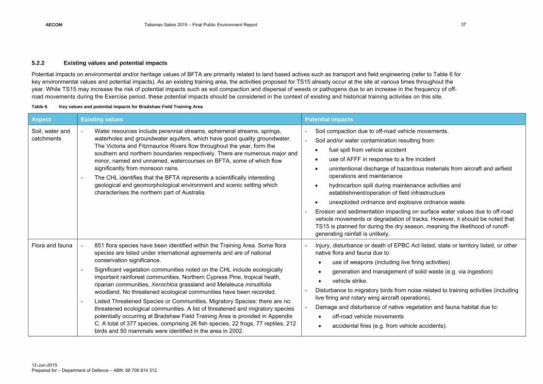
AECOM Talisman Sabre 2015 – Final Public Environment Report
12-Jun-2015 Prepared for – Department of Defence – ABN: 68 706 814 312
37
5.2.2 Existing values and potential impacts
Potential impacts on environmental and/or heritage values of BFTA are primarily related to land based actives such as transport and field engineering (refer to Table 6 for key environmental values and potential impacts). As an existing training area, the activities proposed for TS15 already occur at the site at various times throughout the year. While TS15 may increase the risk of potential impacts such as soil compaction and dispersal of weeds or pathogens due to an increase in the frequency of off-road movements during the Exercise period, these potential impacts should be considered in the context of existing and historical training activities on this site.
Table 6 Key values and potential impacts for Bradshaw Field Training Area
Aspect Existing values Potential impacts
Soil, water and catchments
- Water resources include perennial streams, ephemeral streams, springs, waterholes and groundwater aquifers, which have good quality groundwater. The Victoria and Fitzmaurice Rivers flow throughout the year, form the southern and northern boundaries respectively. There are numerous major and minor, named and unnamed, watercourses on BFTA, some of which flow significantly from monsoon rains.
- The CHL identifies that the BFTA represents a scientifically interesting geological and geomorphological environment and scenic setting which characterises the northern part of Australia.
- Soil compaction due to off-road vehicle movements.
- Soil and/or water contamination resulting from:
fuel spill from vehicle accident
use of AFFF in response to a fire incident
unintentional discharge of hazardous materials from aircraft and airfield operations and maintenance
hydrocarbon spill during maintenance activities and establishment/operation of field infrastructure
unexploded ordnance and explosive ordnance waste.
- Erosion and sedimentation impacting on surface water values due to off-road vehicle movements or degradation of tracks. However, it should be noted that TS15 is planned for during the dry season, meaning the likelihood of runoff-generating rainfall is unlikely.
Flora and fauna - 851 flora species have been identified within the Training Area. Some flora species are listed under international agreements and are of national conservation significance.
- Significant vegetation communities noted on the CHL include ecologically important rainforest communities, Northern Cypress Pine, tropical heath, riparian communities, Xerochloa grassland and Melaleuca minutifolia woodland. No threatened ecological communities have been recorded.
- Listed Threatened Species or Communities, Migratory Species: there are no threatened ecological communities. A list of threatened and migratory species potentially occurring at Bradshaw Field Training Area is provided in Appendix C. A total of 377 species, comprising 26 fish species, 22 frogs, 77 reptiles, 212 birds and 50 mammals were identified in the area in 2002.
- Injury, disturbance or death of EPBC Act listed, state or territory listed, or other native flora and fauna due to:
use of weapons (including live firing activities)
generation and management of solid waste (e.g. via ingestion)
vehicle strike.
- Disturbance to migratory birds from noise related to training activities (including live firing and rotary wing aircraft operations).
- Damage and disturbance of native vegetation and fauna habitat due to:
off-road vehicle movements
accidental fires (e.g. from vehicle accidents).

AECOM Talisman Sabre 2015 – Final Public Environment Report
12-Jun-2015 Prepared for – Department of Defence – ABN: 68 706 814 312
38
Aspect Existing values Potential impacts
- Five EPBC Act listed threatened fauna species and 17 migratory species have been recorded at BFTA. EPBC Act listed species recorded at BFTA include the Gouldian Finch, Purple-crowned Fairy-wren and Northern Quoll.
- The place contains a significant breeding population of the Commonwealth-listed endangered Gouldian finch (Erythrura gouldiae) in the vicinity of Mt Thymanan, estimated to contain 5% of the total population of the species. A population of the nationally vulnerable northern sub-species of crested shrike-tit (Falcunculus frontatus whitei) also occurs within the place (AECOM, 2014).
- Primary habitat for the Purple-crowed Fairy-wren at BFTA is Canegrass (Chionachne cyathopoda), particularly when interspersed with Pandanus.
- There are 32 migratory species that have been recorded which include 16 bird species, turtles, whales, the Dugong and the Saltwater Crocodile.
- Three habitats within BFTA are considered core fauna habitats: rocky slopes and gullies with monsoon forest, streams and riparian habitats associated with rocky hills, and grasslands and swamps.
- BFTA is considered part of a regional environmental corridor linking with Gregory National Park and is part of a broader link to the Kimberley region.
Heritage - BFTA is entered on the CHL, classed as a Natural Heritage Place.
- Defence has an Indigenous Land Use Agreement with the traditional owners of the site.
- The Aboriginal Areas Protection Authority (AAPA) has records of 160 Registered Aboriginal Sacred Sites on BFTA. Additional Sacred Sites are recorded as within 1 km outside of the BFTA boundary, with many likely to overlap the BFTA boundary due to their extents (AECOM, 2014).
- The BFTA Heritage and Environmental Management Plan (AECOM, 2014) details procedures for the protection of culturally significant sites.
- There are also a number of places and objects relating to early Non-Indigenous activities and occupation in the area.
- Damage on Indigenous and/or Non-Indigenous Heritage values due to:
use of weaponry (including live firing activities and/or emergency jettisoning of ordnance)
unexploded ordnance and explosive ordnance waste
off-road vehicle movements
field engineering
establishment of ancillary infrastructure required for the exercise (e.g. wash-points).

AECOM Talisman Sabre 2015 – Final Public Environment Report
12-Jun-2015 Prepared for – Department of Defence – ABN: 68 706 814 312
39
Aspect Existing values Potential impacts
Social, amenity and economic values
Key social values for the Timber Creek community include:
- the Traditional Owner access to sacred sites and protection of sacred sites within the site boundary.
- The settlement of Timber Creek, which borders BFTA and has a population of 231 (2011 census). Key contributors to the town’s economy are its status as a stop on the Darwin-Broome coach route, and the presence of an airstrip which may be used by workers employed in mining exploration.
- Several large pastoral leases are proximate to the site.
Ongoing management of BFTA includes landholder and community consultation, as well as an Environmental Advisory Committee with local representation.
- Damage to public roads from military convoy.
- Noise impacts on sensitive receivers from exercise activities (e.g. firing, take-off/landing of rotary wing aircraft)
- Increased road congestion on nearby roads, resulting in amenity (e.g. noise, increased travel times) impacts and loss of income for businesses.
- Adverse economic, amenity and safety impact on adjacent landholders in the event of bushfire.
Note also that impacts to indigenous heritage values may have social consequences for the local community.
Biosecurity A total of 14 weed species have been recorded, six of which are declared noxious as defined by the Northern Territory Weed Management Act, of which three pose a serious threat to conservation – Parkinsonia (also a Weed of National Significance), Noogoora Burr (Xanthium pungens) and Rubber Bush (Calotropis procera).
- Weed, seed or pathogen dispersal due to activities such as:
rotary wing aircraft operations
the establishment and operation of field infrastructure and target areas
off-road vehicle movements
land transit between training areas
management of solid waste generated on-site.
- Increase in pest fauna species due to generation and management of solid waste.

AECOM Talisman Sabre 2015 – Final Public Environment Report
12-Jun-2015 Prepared for – Department of Defence – ABN: 68 706 814 312
40
5.2.3 Site-specific policies, plans and control measures
In addition to the Defence-wide environmental management processes (e.g. Defence EMS, SOs) described in Section 3.0 and the overarching TS15-specific controls (e.g. TS15 EMP, EMG), the following site-specific environmental controls apply to activities at BFTA:
- Bradshaw Field Training Area Heritage and Environmental Management Plan (AECOM, 2014): provides an integrated framework and strategies for management of the significant natural and cultural heritage values at BFTA, including management requirements during major exercises.
- Bradshaw Field Training Area Sustainability Monitoring and Reporting Plan: reviews values and activities and specifies monitoring activities and thresholds that trigger specific management actions.
- Indigenous Land Use Agreement: requires all Defence activities to be undertaken in accordance with Defence Activity Plans, which are subject to consultation and approval with traditional owners represented by the Northern Land Council.
Refer to Section 6.7 of this PER for details of issue-specific (e.g. weed management) environmental controls to be included as part of the TS15 EMP.

AECOM Talisman Sabre 2015 – Final Public Environment Report
12-Jun-2015 Prepared for – Department of Defence – ABN: 68 706 814 312
41
5.3 Mount Bundey Training Area
5.3.1 Location and access
The Mount Bundey Training Area (MBTA) covers approximately 117,300 ha and is located approximately 115 km south east of Darwin Central Business District in the Northern Territory. The site is bounded by the Arnhem Highway to the north, Mary River and the proposed Mary River National Park to the west, and Kakadu National Park to the east through to the south.
MBTA was established to support training in field manoeuvres and live firing. It has field firing areas, high explosive impact areas, training sectors and infrastructure to support management and operational use. Infrastructure at the site is limited, and includes a road network, maintenance areas, a Range Control facility, a 200 person Scale A campsite and a number of support facilities, including built ranges.
Access to MBTA is provided via the Arnhem Highway, which has direct connection to Stuart Highway, providing direct transport link to Darwin. The site has an internal road network of unsealed gravel roads appropriate for all weather use, although movement is generally restricted during the wet season to prevent damage to roads and tracks, as well as damage to vehicles. A regional map showing MBTA is provided in Figure 4.
Figure 4 Mount Bundey Training Area Locality Plan

AECOM Talisman Sabre 2015 – Final Public Environment Report
12-Jun-2015 Prepared for – Department of Defence – ABN: 68 706 814 312
42
5.3.2 Existing values and potential impacts
Potential impacts on environmental and/or heritage values of MBTA are primarily related to land based activities such as transport, live firing exercises and field engineering (refer to Table 7 for key environmental values and potential impacts). The site itself is on the CHL for its natural values, including its variety of fauna habitats of waterways, floodplains and rainforest pockets supporting a range of species, meaning impacts on native flora and fauna values are possible.
As an existing training area, most of the activities proposed for TS15 already occur at the site at various times throughout the year, therefore the potential for adverse impacts on the natural environment should be considered in the context of year-round training activities at the site.
Table 7 Key values and potential impacts for Mount Bundey Training Area
Aspect Existing values Potential impacts
Soil, water and catchments
The MBTA is drained to the north-west and north-east by the Mary and Wildman Rivers respectively, both of which form part of Wetlands of National Importance. The Mary River forms a floodplain in the western portion of the site. There are also numerous unnamed watercourses across the site, many of which only flow during the wet (monsoon) season.
- Erosion and sedimentation impacting on surface water values, including Wetlands of National Importance. Note however that as a floodplain monsoon area, it has adapted to high levels of sedimentation. Additionally, as the Exercise will take place in the dry season, the risk of sedimentation is low.
- Soil compaction due to off-road vehicle movements.
- Soil and/or water contamination resulting from:
fuel spill from a vehicle accident
use of AFFF in response to a fire incident
unintentional discharge of hazardous materials from aircraft and airfield operations and maintenance
unexploded ordnance and explosive ordnance waste
hydrocarbon spill during maintenance activities and establishment/operation of field infrastructure.
Flora and fauna
- The area is predominantly vegetated by Melaleuca savannah woodlands and open forests, along with grassed floodplains. Significant vegetation communities include vine (monsoon rainforest) thickets, which provide important seasonal and short-term refuge for fauna.
- MBTA has a high diversity of significant fauna habitats, including seasonal Melaleuca and grassland floodplains, as well as permanent waterholes and waterways of the Mary and Wildman Rivers and Craig Creek rockholes, which are valuable dry season fauna refuges.
- Baseline surveys have recorded a total of 270 fauna species at the MBTA, including 140 birds, 60 reptiles, 17 frogs, 28 mammals and 25 fish.
- Injury, disturbance or death of EPBC Act listed, state or territory listed, or other native flora and fauna due to:
use of weaponry (including live firing activities)
generation and management of solid waste (e.g. via ingestion)
vehicle strike.
- Disturbance to migratory birds from noise related to training activities (including live firing and rotary wing aircraft operations)
- Damage and disturbance of native vegetation and fauna habitat due to:
off-road vehicle movements

AECOM Talisman Sabre 2015 – Final Public Environment Report
12-Jun-2015 Prepared for – Department of Defence – ABN: 68 706 814 312
43
Aspect Existing values Potential impacts
- Nine EPBC listed threatened species have been recorded on MBTA, including the Gouldian Finch, Red Goshawk, Masked Owl, Northern Quoll, and Bare-rumped Sheathtail Bat.
- MBTA borders Kakadu National Park. Kakadu National Park is entered on the World Heritage List and a Ramsar site.
- Nine threatened and eight migratory species have been recorded at MBTA. A list of threatened and migratory species potentially occurring at MBTA is provided in Appendix D.
accidental fires (e.g. from vehicle exhaust and live firing)
establishment of ancillary infrastructure required for the Exercise (e.g. wash-points).
Heritage - One registered and one recorded Indigenous sacred site exists at MBTA, with 117 archaeological sites recorded.
- Listed on the CHL for its natural heritage values.
- MBTA contains no known non-Indigenous heritage sites.
- Damage on Indigenous Heritage values due to:
use of weaponry (including live firing and/or emergency jettisoning of ordnance)
off-road vehicle movements
field engineering
establishment of ancillary infrastructure required for the Exercise (e.g. wash-points).
- Damage to natural values contributing to the site’s listing on the CHL.
Social, amenity and economic values
- The MBTA is approximately 115 km to the south-east of Darwin and approximately 100 km to the west of the town of Jabiru. There are no townships or small villages in the vicinity. The area is large pastoral grazing land uses with extremely low population levels.
- There is significant use of Arnhem Highway for tourist vehicles to and from the adjacent Kakadu National Park. Jim Jim Road, which bisects MBTA, is a public road that is occasionally used.
- Damage to public roads from military convoy.
- Adverse economic, amenity and safety impact on adjacent landholders/road users in the event of bushfire.
Note also that impacts to indigenous heritage values may have social consequences for the local community.
Biosecurity At least six weed species have been recorded at the MBTA, including three Weeds of National Significance species: Gamba Grass (Andropogon gayanus), Lantana (Lantana camara) and Prickly Acacia (Vachellia nilotica).
- Weed, seed or pathogen dispersal due to activities such as:
aircraft operations and maintenance
the establishment and operation of field infrastructure and target areas
off-road vehicle movements
land transit between training areas
management of solid waste (including excess topsoil) generated on-site.
- Increase in pest fauna species due to generation and management of solid waste.

AECOM Talisman Sabre 2015 – Final Public Environment Report
12-Jun-2015 Prepared for – Department of Defence – ABN: 68 706 814 312
44
5.3.3 Site-specific policies, plans and control measures
In addition to the Defence-wide environmental management processes (e.g. Defence EMS) described in Section 3.0, and the overarching TS15-specific controls (e.g. TS15 EMP, the following site-specific environmental controls apply to activities at the MBTA:
- Mount Bundey Heritage and Environmental Management Plan (AECOM, 2010): provides an integrated framework and strategies for management of the significant natural and cultural heritage values at MBTA, including management requirements during major exercises.
- Mount Bundey Training Area Sustainability Monitoring and Reporting Plan which reviews values and activities and specifies monitoring activities and thresholds that trigger specific management actions.
Refer to Section 6.7 of this PER for details of issue-specific (e.g. weed management) environmental controls to be included as part of the TS15 EMP.

AECOM Talisman Sabre 2015 – Final Public Environment Report
12-Jun-2015 Prepared for – Department of Defence – ABN: 68 706 814 312
45
5.4 Delamere Range Facility
5.4.1 Location and access
The Delamere Range Facility (DRF) is located approximately 125 km south-west of Katherine, Northern Territory, on the eastern edge of the Sturt Plateau. Accessed by the Buntine Highway via the Victoria Highway, the DRF is a gazetted Defence Practice Area important for air-to-ground and on-ground weapons firing and bombing training. These activities support operational readiness training in offensive air and ground support and strategic interdiction. A regional map showing the DRF area is provided in Figure 5.
Figure 5 Delamere Range Facility Locality Plan

AECOM Talisman Sabre 2015 – Final Public Environment Report
12-Jun-2015 Prepared for – Department of Defence – ABN: 68 706 814 312
46
5.4.2 Existing values and potential impacts
DRF lies at the southern reach of the seasonal monsoon high rainfall zone and the northern reach of the arid inland zone. As a consequence, it contains vegetation characteristic of both these climatic zones. Vegetation primarily consists of woodland and forest communities with broad, shallow drainage lines supporting sparse to dense grassland and open woodland. DRF is broadly contained within a poorly-watered, flat to gently undulating plateau, which consists of a virtually featureless plain with entrenched broad shallow valleys up to 1 km wide. These form the headwater catchment of several creeks to the north east. The landscape comprises all the elements of the erosion sequence including source, transit and sink areas.
As a land-bound Range Facility with few permanent water features, potential impacts of medium or higher significance to the environmental values of the DRF are primarily related to air-to-ground live firing activities (refer to Table 8 for key environmental values and potential impacts).
While TS15 may increase the risk of potential impacts such as soil compaction and dispersal of weeds and/or pathogens (the site is relatively free of weeds), the site is an existing Gazetted Defence Practice Area, and as such these potential impacts should be considered in the context of ongoing training activities on the site.
Table 8 Key values and potential impacts for Delamere Range Facility
Aspect Existing values Potential impacts
Soil, water and catchments
Ephemeral streams are located throughout the site and carry significant flows during the monsoon period from December to February. There are no significant permanent natural water sources on the site. Two dams have been constructed within the site boundary to provide for local water requirements.
- Soil and/or water contamination resulting from:
use of AFFF in response to a fire incidents
emergency discharge of hazardous materials from aircraft
unexploded ordnance and explosive ordnance waste.
While soil erosion is possible, resultant sedimentation impacts on waterways are unlikely due to the timing of TS15 during the dry season and the relative lack of permanent water features on-site.
Flora and fauna
- The vegetation is mainly low open Eucalypt woodland with some Acacia scrubland and tussock grasslands that have been heavily modified by grazing. The laterite areas are generally woodland and forest communities with grassland, varying from sparse to dense and open woodland in the broad shallow drainage lines. The site overlaps a seasonally high rainfall zone and an arid inland zone and consequently contains natural features characteristic of both.
- Most on-site fauna is either common or abundant. A list of threatened and migratory species potentially occurring in DRF is provided in Appendix E.
- Past surveys indicate that the site supports approximately 59 bird species.
- Injury, disturbance or death of terrestrial EPBC Act listed, state or territory listed, or other native flora and fauna due to:
use of weaponry (including live firing activities)
generation and management of solid waste (e.g. via ingestion).
- Damage and disturbance of native vegetation and fauna habitat due to accidental fires (e.g. from live firing).

AECOM Talisman Sabre 2015 – Final Public Environment Report
12-Jun-2015 Prepared for – Department of Defence – ABN: 68 706 814 312
47
Aspect Existing values Potential impacts
Heritage - Archaeological surveys of the range identified archaeological sites restricted to waterways and significant landform features (the western escarpment).
- Aboriginal sacred site clearances identified a number of sacred sites associated with major landforms (escarpments, waterholes etc.) and natural features (lancewood and bullwaddy stands)
- An ILUA is in place for DRF.
- Damage on previously unrecorded Indigenous Heritage values due to:
use of weaponry (including live firing activities and/or emergency jettisoning of ordnance)
contamination due to unexploded ordnance or explosive ordnance waste.
Social, amenity and economic values
The DRF is extremely remote, with low population densities in adjacent areas. The Victoria Highway, which runs between Katherine and Kununurra, bisects the site.
None identified.
Biosecurity - The range facility is largely free of weed infestation. Weeds have been identified including a small number of introduced Rubber Bush (Calotropis procera) located at Browns Dam in the north-west of the property and the native pastoral weed Mint Weed (Hyptis suaveolens) adjacent to the Dry River.
- Feral pigs are relatively common. Cats and dingoes have been seen, but are not considered to be present in high numbers. As many as 150 cattle remain on the DRF.
None identified.

AECOM Talisman Sabre 2015 – Final Public Environment Report
12-Jun-2015 Prepared for – Department of Defence – ABN: 68 706 814 312
48
5.4.3 Site-specific policies, plans and control measures
The Defence-wide environmental management processes described in Section 3.0 and the overarching TS15-specific controls (e.g. TS15 EMP, EMG) will apply to activities at the DRF. Refer to Section 6.7 of this PER for details of issue-specific (e.g. weed management) environmental controls to be included as part of the TS15 EMP.

AECOM Talisman Sabre 2015 – Final Public Environment Report
12-Jun-2015 Prepared for – Department of Defence – ABN: 68 706 814 312
49
5.5 Northern Territory beach landing sites
5.5.1 Location and access
Amphibious beach landing training activities (an amphibious rehearsal followed by an actual landing) are proposed to take place at the beach landing sites (BLSs) of Native Point and Stingray Head in Fog Bay, Northern Territory, approximately 65 km south-west of Darwin. Subsequent training activities will be undertaken at the Dundee Beach Air Strip and the Finniss River Station. The activity locations in this report are defined as the Northern Activity Area, which encompasses Native Point and the nearby Dundee Beach Air Strip, and the Southern Activity Area, which encompasses Stingray Head and parts of the Finniss River Station.
The activities are planned over approximately five consecutive days. Activities will involve landing of infantry and vehicles from landing craft, LCAC (hovercraft), and troop lift helicopters. These will be supported by other aircraft flying at low level simulating air cover for the landings. Conventional and lightly armoured vehicles will conduct limited manoeuvre in the hinterland areas of Native Point and Finniss River Station. Firing of blank ammunition will take place during the activity. Travel between the beach landing sites and the Finniss River Station will be by public roads and tracks. At the conclusion of the activity the participants will gather in administrative locations to clean vehicles and prepare for a road move to their next training location.
The activities proposed at these sites have been subject to a separate environmental impact assessment, TS15 Northern Territory Beach Landing Exercise Report (AECOM, 2015). The report provides additional detail on the proposed activities, and incorporates specialist reports that assessed potential marine fauna (Guinea, 2015) and bird impacts (Bamford, 2015). The report concluded that, based on the description of the action and outcomes of the impact assessment, that the beach landing and inland manoeuvre activities will not have a real chance or possibility of resulting in an impact on a MNES or ‘the environment’ as defined in Section 525 of the EPBC Act. The short-term nature of the action in combination with implementation of recommended mitigation measures supported this conclusion.
As mentioned in Section 2.4, the Northern Territory Department of Land, Planning and Environment has granted Defence permission to utilise the intertidal zone near Native Point and Stingray Head for the purpose of undertaking the amphibious beach landings for the period of the Exercise.
A locality map showing the proposed NT beach landing sites is provided as Figure 6.
Figure 6 NT beach landing sites locality plan

AECOM Talisman Sabre 2015 – Final Public Environment Report
12-Jun-2015 Prepared for – Department of Defence – ABN: 68 706 814 312
50
5.5.2 Existing values and potential impacts
Fog Bay, which encompasses the beach landing sites of the Northern Activity Area and Southern Activity Area, has been classified as a site of conservation significance by the NT Government (NT Department of Natural Resources, Environment, The Arts and Sport). This includes the coastline of Fog Bay, which is largely dominated by sandy beaches and grassy dunes to the north and tidal flats to the south. The mouth of Finniss River is immediately to the south of the Southern Activity Area; and the Finniss River coastal floodplain extends into the Southern Activity Area. This floodplain has been designated by BirdLife International as an Important Bird Area.
The sandy beaches of Fog Bay are recognised as an important nesting, breeding and feeding site for the Flatback Turtle, and the surrounding waters are important feeding areas for four other species of marine turtle. The area is also considered important habitat for migratory shorebirds, seabirds and waterbirds; however, when present in the region, the majority of these are found in the mangroves near the mouth of the Finniss River and on the tidal flats to the south of the river mouth which are outside the Activity Areas (AECOM, 2015).
The beach landing sites are generally in good condition, although the areas in the vicinity of Dundee Beach township (located between the beach landing sites on the Timor Sea) have a relatively high level of weed infestation, most likely attributable to heavy recreational use. The primary land uses of the Northern Activity Area and Southern Activity Area are traditional indigenous land uses, recreational activities, tourism, pastoral/agricultural activities (Finniss River Station) and commercial fishing. Finniss River Station supports large areas of grassland that are seasonally inundated (Bamford, 2015). The Station environment is presumed to be modified given it is used for cattle grazing and associated agriculture.
In order to ensure the protection of Indigenous Heritage and of any sacred site, Defence has applied to the NT Aboriginal Areas Protection Authority (AAPA) to obtain an Authority Certificate to undertake the amphibious landing component of the Exercise at Fog Bay. Defence will comply with all of the conditions placed on the Exercise as stated on the Authority Certificate and will plan and undertake Exercise activities accordingly. The TS15 PER website will be updated when the Authority Certificate has been issued by AAPA (see: http://www.aecom.com/Where+We+Are/Australia+-+New+Zealand/Publications/Talisman+Sabre/Talisman+Sabre+2015).
Refer to Table 9 for key environmental values and potential impacts at the Activity Areas.
Table 9 Key values and potential impacts for Northern Territory beach landing sites
Aspect Existing values Potential impacts
Soil, water and catchments
- Native Point and Stingray Head are located within the Darwin Coastal Bioregion.
- The Activity Areas are characterised by sandy beaches, grassy dunes and intertidal mudflats backed by mangroves and coastal floodplains which are important fauna habitat elements.
- Both Native Point and Stingray Heads have tidal creeks which come from small low lying swamp behind the sand dunes.
- The floodplain is inundated seasonally, with near-permanent water in deeper channels and billabongs. Tidal areas are inundated twice daily. There is a small, mangrove-lined tidal creek at the southern end of the Stingray Head landing area, and much larger mangrove systems to the north-east and to the south associated with the Finniss River (Bamford, 2015). The activities will take place outside of the northern monsoon season.
- Soil and/or water contamination resulting from fuel spill from refuelling activities and/or vehicle accident.
- Fuel spill from vessel, vehicle or other equipment resulting in soil and/or water contamination.
- Fuel spill from refuelling activities resulting in soil and/or water contamination - Exposure of acid sulfate soil potentially generating acidic leachate leading to
impacts on soils, water quality, and vegetation. - Water contamination due to ineffective wastewater containment and/or runoff - Potential impacts of amphibious landings:
Damage to beach substrate Coast dune erosion from vehicles Alteration of natural drainage systems Deep rutting if vehicles drive on inundated land areas.

AECOM Talisman Sabre 2015 – Final Public Environment Report
12-Jun-2015 Prepared for – Department of Defence – ABN: 68 706 814 312
51
Aspect Existing values Potential impacts
- The beaches of the Northern Activity and Southern Activity Areas are both fringed by unstable sand dunes. The beaches in the area of the proposed activities have a thin covering of sand often less than 40 cm over the bedrock (Guinea, 2015). Informal tracks are present at both these beaches (Bamford, 2015).
- Acid sulfate soils are known to occur within coastal areas of the NT. The Acid Sulfate Soils of the Darwin Region (NRETAS Technical Report No.09/2008D) identifies the areas around the Northern Activity Area as land susceptible to acid sulfate soil risk, which varies within the study areas from ‘High’ to ‘Low’.
- The Finniss Floodplain and Fog Bay System, which includes the beach landing sites, are listed on the Nationally Important Wetlands (reference number: NT025) and meet criteria 1, 2, 3, 4 and 6.
Flora and fauna
- Two flora species listed as vulnerable under the NT TPWC Act have potential to occur within the Northern Activity Area and Southern Activity Area:
Armstrong’s Cycad Cycas armstrongii
Arrowleaf Monochoria Monochoria hastata.
- The Arrowleaf Monochoria is likely to occur within the wet back-swamps and drainage channels located behind the sand dunes at both beach landing sites. Cycad species were noted throughout the forest areas of the Northern Activity Area during the site inspection, although the unlisted Cycas maconochiei is known to be common in this area.
- No species of flora listed under the EPBC Act are considered likely to occur within either Activity Areas or surrounding areas. Fog Bay is known to support fourteen species of plants that are endemic to the NT (NRETAS, 2014).
- Fog Bay is recognised as important habitat for marine mammals, turtles and migratory birds. It is known to support Dugong Dugong dugong, Indo-Pacific hump-backed Dolphin Sousa chinensis, Irrawaddy Dolphin Orcaella brevirostris, Australian Snubfin Dolphin Orcaella heinsohni, and Bottle-nosed Dolphin Tursiops truncatus (Whiting, 1997), all of which are listed under the EPBC Act as migratory species. There are also records for Australian Snubfin Dolphin and the Indo-Pacific hump-backed Dolphin in proximity to both Activity Areas. Additionally, there has been a recent confirmed sighting of a northern population of Orca Orcinus Orca in the waters off Fog Bay.
- ‘Fog Bay and adjacent islands’ is also recognised as an ‘internationally important site’ for five migratory shorebird species (Bamford et al., 2008):
- Injury, disturbance, disorientation or death of EPBC Act listed fauna, including turtle egg development and waterbird colonies, due to:
vessel/vehicle strike
beach and substrate compaction
excessive noise from landing craft, air craft, firing and personnel manoeuvres.
- Light-spill on the beach leading to disruption of turtles moving ashore to lay eggs, and hatchlings moving towards the sea.
- Light-spill affecting terrestrial bird and mammal species movements in the hinterland regions.
- Damage and disturbance of native vegetation and fauna habitat due to:
off-road vehicle movements (including large vehicle manoeuvre on beaches)
accidental fires (e.g. from vehicle accidents)
establishment of ancillary infrastructure required for the Exercise (e.g. wash-points and temporary accommodation).
- Reef and/or benthic flora damage due to grounding of ships and/or other watercraft.
The action is likely to coincide with the peak nesting period for Flatback Turtle, and the tail-end of nesting for Olive Ridley, however it is understood that there is likely to be a low level of nesting along both the Native Point and Stingray Head beach landing sites during the action. (Guinea pers. comm. 23 September 2014 as reported

AECOM Talisman Sabre 2015 – Final Public Environment Report
12-Jun-2015 Prepared for – Department of Defence – ABN: 68 706 814 312
52
Aspect Existing values Potential impacts
Black-tailed Godwit Limosa limosa
Great Knot Calidris tenuirostris
Greater Sand Plover Charadrius leschenaultii
Grey-tailed Tattler Tringa brevipes
Terek Sandpiper Xenus cinereus.
- Internationally important sites support at least 1% of the total population of a species or subspecies of migratory shorebird (Bamford et al., 2008). BirdLife Australia also considers ‘Fog Bay and Finniss River Floodplains’ as an Important Bird Area (IBA) and of global significance, with the IBA extending into the Southern Activity Area footprint.
- Migratory shorebirds have been found within and in close proximity to the Activity Areas, but tend to congregate in the south of Fog Bay where the mud flats and tidal flats are more expansive
- The sandy beaches and some nearby islands of Fog Bay are known nesting sites for the EPBC vulnerable listed Flatback Turtle Natador depressus, and the surrounding waters are important feeding areas for other EPBC listed turtle species such as the Olive Ridley Lepidochelys olivacea, Green Turtle (Chelonia mydas, Loggerhead Turtle Caretta caretta and Hawksbill Turtle Eretmochelys imbricata. Nesting season for the Flatback Turtle is between April to October, peaking between May and July.
- The DoE PMST identified the following EPBC Act listed values as having a moderate or greater likelihood of occurring within the Activity Areas and/or adjoining areas:
Ten species listed as threatened under the EPBC Act, consisting of two mammal species, five reptile species, three shark and ray species
Fifty-six migratory species consisting of 41 bird species, eight mammal species, six reptile species and two shark or ray species
Of the 41 migratory bird species identified, Fog Bay is recognised as an internationally important site for the following five species:
Black-tailed Godwit
Great Knot
Greater Sand Plover
Grey-tailed Tattler
Terek Sandpiper
in AECOM, 2015).
Due to the timing of TS15, the majority of migratory shorebirds are expected to be in their northern breeding grounds during the TS15 activities in July. However, some species may nonetheless be present, particularly Greater Sand Plover which arrives in northern Australia in late July.

AECOM Talisman Sabre 2015 – Final Public Environment Report
12-Jun-2015 Prepared for – Department of Defence – ABN: 68 706 814 312
53
Aspect Existing values Potential impacts
78 listed marine species, including 22 birds, 28 fish (including pipefish and sea horses), one mammal and 27 reptiles
Twelve whale and cetacean species.
- One Commonwealth Marine Area – the North Marine Region – lies within a 10 km radius of the Activity Areas. TS15 activities that occur within the Timor and Arafura Seas will fall within the North Marine Region (covered in Section 5.10). The North Marine Region provides habitat for a diverse range of marine fauna including threatened turtles and sawfish.
A list of threatened and migratory species potentially occurring at and in the vicinity of the Activity Areas is provided in Appendix E and Appendix G.
Heritage
- AAPA has identified a number of sacred sites within and in the vicinity of the Northern and Southern Activity Areas, area are likely associated with geological features (rocky outcrops, headlands etc.).
- The Fog bay region contains or is utilised for other heritage values. These include the cultural values of bush food and medicine, and resource gathering locations (turtle rookeries, fisheries etc.)
- Potential and undiscovered archaeology may also occur in the form of shell midden deposits, stone artefact scatters and raised beach sand dunes (>1m in height) where burials may have occurred
- Beauty Leaf trees Calophyllum inophyllum are present along the tops of the dunes. These trees are known to be used by traditional landowners for wood and nuts, and children play marbles with the nuts of the beauty-leaf tree. The trees are an aboriginal resource and are one of the preferred sources for ocean going craft.
- There are no registered items of Commonwealth Heritage or other places recognised as having heritage values under the Commonwealth Heritage List (CHL) identified within 10 km of both Activity Areas.
- There are no known built heritage values within the Activity Areas.
- Potential for archaeological material to be disturbed during preparation and implementation of field exercises.
- Damage or disturbance to a significant Aboriginal sites/places/areas due to:
off-road vehicle movements
establishment of ancillary infrastructure required for the Exercise (e.g. wash-points)
excavations within restricted works area, particularly along Native Point beach.

AECOM Talisman Sabre 2015 – Final Public Environment Report
12-Jun-2015 Prepared for – Department of Defence – ABN: 68 706 814 312
54
Aspect Existing values Potential impacts
Social, amenity and economic values
The beach landing sites are located on Crown leasehold land and many small portions of freehold land around the community of Dundee Beach. The main land uses of Stingray Head and Native Point are for traditional indigenous activities such as hunting, fishing and camping and other cultural activities, as well as rural residential living, recreational activities, tourism, and commercial fishing in the adjacent waters. Between the beach landing sites is the town of Dundee and tourist park and the Lodge of Dundee. Dundee and its surrounds are a popular tourist destination that attracts high numbers of tourists relative to its size and location.
- Temporary exclusions and loss of recreational values at the beach landing sites for the period of the training activity
- The exercise will also result in movement of personnel and equipment on public roads through Dundee. This may result in some minor and transitory impacts on amenity for local residents, but is also likely to result in some economic benefits for local businesses due to increased patronage by military and civilian personnel involved in TS15.
- Noise from aircraft (rotary and fixed wing) leading to amenity impacts to residences and beach users, and agricultural activity/stock management
- Note also that impacts to indigenous heritage values may have social consequences for the local community.
Biosecurity - Fog Bay is generally considered in good condition; however, the beach landing sites have been degraded over time by heavy recreational use. Weed species were noted alongside the numerous access tracks and on top of the grassy dunes where the public establish camping sites and use 4WD and quad bikes. Weed species, as classified by the NT Weeds Management Act, that are known to occur within the BLS include: four Weeds of National Significance: Olive Hymenachne Hymenachne
amplexicaulis, Mimosa Mimosa pigra, Salvinia Salvinia molesta, Gamba grass Andropogon gayanus
ten species listed as declared weeds under the NT Weeds Management Act 2001, including the four WONS above, and: Caltrop Tribulus cistoides Hyptis Hyptis suaveolens Mission Grass Pennisetum polystachyon Mossman River Grass Cenchrus echinatus Spinyhead sida Sida acuta Water Lettuce Pistia stratiotes
A number of declared feral species under the NT TPWC Act have also been recorded in the Fog Bay area, and may be found in the Activity Areas: Feral Cattle Bos taurus Feral Horse Equus caballus Feral Pig Sus scrofa.
- Introduction/dispersal of weeds/pathogens, including Weeds of National Significance, and feral fauna due to activities such as: off-road vehicle movements land transit between training areas, particularly transit from the beach
landing sites to MBTA management of solid waste generated on-site.
- Increase in pest fauna species due to generation and management of solid waste.

AECOM Talisman Sabre 2015 – Final Public Environment Report
12-Jun-2015 Prepared for – Department of Defence – ABN: 68 706 814 312
55
5.5.3 Site-specific policies, plans and control measures
In addition to the Defence-wide environmental management processes described in Section 3.0 and the overarching TS15-specific controls (e.g. TS15 EMP, EMG), the following site-specific environmental controls apply to activities at NT beach landing sites.
- Environmental Awareness DVD: Specific information on the values present at NT beach landing sites will be included in the TS15 Combined Exercise DVD. Introductory information will be provided about the location and boundaries of NT beach landing sites and significant environmental attributes such as the Marine Park and training area history will be identified. In addition to the information regarding general environmental management in the ADF, it will outline site-specific controls including the NT Beach Landing Sites Awareness Card.
- Additional environmental and heritage management measures to lower the risk of adverse impact resulting from the activities will include:
Overarching procedural measures, such as:
the presence of an EMG team member throughout the beach landing activity to monitor the preparation for and conduct of the activities, positioning and to assess and manage any residual impacts following the training activities
positioning of sentries at all entry points to the activity area (including the beach) to ensure public safety is maintained
clear demarcation of sensitive (restricted access) areas for avoidance prior to undertaking the training activities
provision and communication of important environmental/heritage values and constraints information (including maps indicating access restricted areas) to activity managers and participants in a format that allows for easy and effective implementation, such as through pre-activity briefings
integration of the measures prescribed in this report into the ECC framework and related operational controls.
Specific beach landing activity risk mitigation measures to address the following potential issues and concerns:
noise, vibration and light impacts to residences and fauna
the risk of fuel leaks and spills
weed introduction and dispersal
the risk of coastal dune erosion
the risk of acid sulfate soil exposure
the protection of foraging and nesting fauna
biosecurity issues such as the introduction and dispersal of weeds and pathogens
the protection of known and unknown indigenous heritage values.
Refer to Section 6.7 of this PER for details of issue-specific (e.g. weed management) environmental controls to be included as part of the TS15 EMP.
Further information is also available through the TS15 Northern Territory Beach Landing Exercise Report (AECOM, 2015).

AECOM Talisman Sabre 2015 – Final Public Environment Report
12-Jun-2015 Prepared for – Department of Defence – ABN: 68 706 814 312
56
5.6 Lee Point, Northern Territory
5.6.1 Location and access
Lee Point in the Casuarina Coastal Reserve is located in Darwin's northern suburbs (19 km from the city centre) and can be accessed via the Rapid Creek, Trower Road (Brinkin), Lee Point or Buffalo Creek Roads. The Casuarina Coastal Reserve is bound to the east by the Buffalo Creek Management Area.
The activities proposed for Lee Point constitute the purely administrative movements of offloading and backloading that cannot be undertaken at Darwin Port for logistical reasons. In brief, the USN and USMC will conduct a vehicle offload over the beach at Lee Point over one to two days in July ahead of the scheduled Exercise dates. The offload will be conducted from USS Bonhomme Richard, which will be operating offshore in the Beagle Gulf (outside Darwin Port Limits and in water depth >15-20m). Vehicles will be transported to the beach by a number of LCAC (hovercraft) during daylight hours and utilise the existing track to drive from the beach onto the sealed Lee Point Road and depart the area. The vehicles proposed for offload at Lee Point will consist of tractors, quadcons, 7-ton trucks, HMMWVs, LAVs, a dump truck and trailers. Accompanying the vehicles and equipment will be combined party of around 400 persons consisting of drivers, vehicle crews, beach teams and engineers.
Backloading of the above vehicles and crew is scheduled to occur over one day upon completion of the Exercise.
A locality map showing ingress and egress routes is provided in Figure 7.
Figure 7 Lee Point, Casuarina Coastal Reserve NT locality plan

AECOM Talisman Sabre 2015 – Final Public Environment Report
12-Jun-2015 Prepared for – Department of Defence – ABN: 68 706 814 312
57
5.6.2 Existing values and potential impacts
The Casuarina Coastal Reserve comprises 1,361 hectares, which includes a strip of coastline some 8 km in length and adjoining offshore areas. Lee Point lies at the northern most point of the coastal reserve. The coastal reserve is in close proximity to the Darwin suburbs of Brinkin, Tiwi and Rapid Creek. Neighbours to the Reserve include the Royal Australian Air Force, the Royal Darwin Hospital and the Northern Territory University.
The Casuarina Coastal Reserve was gazetted under the Crown Lands Act for the 'recreation and amusement of the public' on 17 September 1982, and management of the area was vested in the Conservation Commission under section the same Act on 18 October 1982. Presently the coastal reserve is managed by the Parks and Wildlife Commission NT on behalf of the NT Government.
Despite being set aside primarily for recreation, the Coastal Reserve protects important natural and cultural values. It is recognised that these natural and cultural values underpin the importance of the area for recreation.
In order to ensure the protection of Indigenous Heritage and of any sacred site, Defence has applied to the NT Aboriginal Areas Protection Authority (AAPA) to obtain an Authority Certificate to undertake the offloading and backloading activities Lee Point. Defence will comply with all of the conditions placed on the Exercise as stated on the Authority Certificate and will plan and undertake Exercise activities accordingly. The TS15 PER website will be updated when the Authority Certificate has been issued by AAPA (see: http://www.aecom.com/Where+We+Are/Australia+-+New+Zealand/Publications/Talisman+Sabre/Talisman+Sabre+2015).
Refer to Table 10 for key environmental values and potential impacts at the Lee Point.
Table 10 Key values and potential impacts for Lee Point
Aspect Existing values Potential impacts
Soil, water and catchments
The most dominant landform in the Coastal Reserve is the intertidal sandflats and offshore reefs. These landforms provide important habitat for marine invertebrates (mainly molluscs), wading birds and marine turtles.
Reefs occur off Lee Point and north of Rapid Creek (Old Man Rock). At extreme low tides the sandflats and the off-shore reef, Old Man Rock, are exposed. Old Man Rock is a registered sacred site.
Above high water mark two major landforms, dunes and beach ridges, and estuarine fringes dominate the Coastal Reserve and Buffalo Creek Management Area.
The dunes and beach ridges include extensive areas of foredune and relict dune systems. The dunes and beach ridges are characterized by dune sands often with calcareous hardpan and the presence of coastal monsoon rainforest and vine thicket.
- Damage to beach substrate
- Coast dune erosion from vehicles
- Alteration of natural drainage systems
- Deep rutting if vehicles drive on inundated land areas.
- Exposure of acid sulfate soils.
However, it is noted that the offloading and backloading will utilise the existing track and any disturbed areas will be remediated immediately following the Exercise.
Flora and fauna
The conservation values of the Casuarina Coastal Reserve arise from the contribution they make to the network of protected areas in the NT and the conservation of biodiversity in the Darwin region. Additionally Casuarina Coastal Reserve is listed on the register of National Estate (Darwin Foreshores) in recognition of its natural and scenic values.
- Injury, disturbance or death of EPBC Act listed fauna due to vehicle strike (including boats), sand compaction and excessive noise.
- Reef and/or benthic flora damage due to grounding of ships and/or other watercraft.

AECOM Talisman Sabre 2015 – Final Public Environment Report
12-Jun-2015 Prepared for – Department of Defence – ABN: 68 706 814 312
58
Aspect Existing values Potential impacts
An EPBC Act PMST search identified 24 threatened and 51 migratory species with the potential to occur within 10 km of Lee Point. A search of the NRM Infonet (NT Gov) indicates that five species of turtle have been recorded within 10 km of the site, specifically Green Turtle, Hawksbill Turtle, Olive Ridley Turtle, Loggerhead Turtle and Flatback Turtle. The NT Parks and Wildlife Commission actively removes turtle eggs from the area. Previous biodiversity monitoring at the Casuarina Coastal Reserve by the NT Government has also observed 26 migratory shorebirds within the area (DNREA 2007).
A list of threatened and migratory species potentially occurring at Lee Point is provided in Appendix G.
However, because LCACs (rather than conventional vessels) will be used, the risk of fauna strike and damage to shallow reefs near Lee Point are significantly reduced.
Heritage Casuarina Coastal Reserve is culturally important to the Larrakia People who are the custodians of sacred sites and sites of significance in this region. Larrakia Aboriginal people also have an interest, and are stakeholders, in the management of other Reserve values.
There is one registered and five recorded sacred sites under the Northern Territory Sacred Sites Act in the Reserve:
- ‘Old Man Rock’ – located offshore from Dripstone Park (registered sacred site).
- ‘Madjamarraba’ – consists of the vegetated zone between Lee Point and a point directly opposite Darraba Nungalinya. No Defence activities are proposed in this area.
- Burial grounds believed to be associated with the Tiwi Islanders.
- Aboriginal battlefield site marked by a large fig tree in the dunes adjacent to the Rapid Creek Open Area.
- The northern tip of Lee Point is a historical lookout point.
- A recorded site at Buffalo Creek.
The Northern Territory Sacred Sites Act protects sites of significance to Aboriginal people whether or not they are recorded.
The whole of the Coastal Reserve is subject to a claim under the Native Title Act. Marine and intertidal areas are subject to a land claim under the Commonwealth Aboriginal Land Rights (Northern Territory) Act.
The Reserve also contains the physical remains of WWII structures, including concrete observation bunkers (Lee Point Strong Point listed on the non-statutory Register of the National Estate). Archaeology associated with WW2 exercises at Lee Point may also be present. These sites are considered to be of historical importance.
- Damage to Indigenous and/or Non-Indigenous Heritage values will be avoided by restricting all vehicle movements on the beach to the existing track and exit from the reserve via the sealed Lee Point Road.
- Defence activities will not be undertaken in the vicinity of any Indigenous sacred sites or the tip of Lee Point which is a historical lookout point. Measures will be in place to manage the unexpected discovery of any sites or artefacts of heritage value.

AECOM Talisman Sabre 2015 – Final Public Environment Report
12-Jun-2015 Prepared for – Department of Defence – ABN: 68 706 814 312
59
Aspect Existing values Potential impacts
Social, amenity and economic values
The Casuarina Coastal Reserve supports a range of recreation and tourism values. This includes:
- Beach/water activities including swimming, canoeing, sailing, and dog walking. Fishing is also popular at Lee Point Beach
- Barbeques and picnicking – public facilities are provided at Lee Point
- Walking and jogging along the beach and unsurfaced inshore tracks
- Recreational cycling along the road and inshore unsurfaced tracks
- A popular nudist beach between Dripstone Cliffs and Lee Point – this lies south of the area proposed for use in TS15.
- Temporary exclusions from the area during the activities.
- Increased road congestion on Lee Point Road and nearby roads. A traffic management plan will implemented to reduce and manage traffic impacts.
Biosecurity Of the 281 species of plants have been recorded in the Coastal Reserve, 56 are introduced species; 12 of these are declared weeds under the Weeds Management Act 2001 (Parks and Wildlife Commission of the Northern Territory, Casuarina Coastal Reserve Management Plan, 2002).
The Parks and Wildlife Commission implement weed management measures as part of the Casuarina Coastal Reserve Management Plan (2002).
Detrimental biosecurity impacts are not expected because of the limited scope of the activities and national quarantine processes that vehicles, equipment and personnel will have already been subjected to. Potential biosecurity impacts include:
- weed, seed or pathogen dispersal
- introduction of marine pests due to hull biofouling.

AECOM Talisman Sabre 2015 – Final Public Environment Report
12-Jun-2015 Prepared for – Department of Defence – ABN: 68 706 814 312
60
5.6.3 Site-specific policies, plans and control measures
In addition to the Defence-wide environmental management processes described in Section 3.0 and the overarching TS15-specific controls (e.g. TS15 EMP, EMG), the following site-specific environmental controls apply to activities at NT beach landing sites.
- Additional environmental and heritage management measures to lower the risk of adverse impact resulting from the activities will include:
Overarching procedural measures, such as:
the presence of an EMG team member throughout the beach landing activity to monitor the preparation for and conduct of the activities, positioning and to assess and manage any residual impacts following the training activities
positioning of sentries at all entry points to the activity area (including the beach) to ensure public safety is maintained
clear demarcation of sensitive (restricted access) areas for avoidance prior to undertaking the training activities
provision and communication of important environmental/heritage values and constraints information (including maps indicating access restricted areas) to activity managers and participants in a format that allows for easy and effective implementation, such as through pre-activity briefings
integration of the measures prescribed in this report into the ECC framework and related operational controls.
Specific beach landing activity risk mitigation measures to address the following potential issues and concerns:
the risk of fuel leaks and spills
weed introduction and dispersal
the risk of coastal dune erosion
the risk of acid sulfate soil exposure
the protection of foraging and nesting fauna
biosecurity issues such as the introduction and dispersal of weeds and pathogens
the protection of known and unknown indigenous heritage values.
Additionally, as part of Exercise planning, Defence continues to consult with the NT Parks and Wildlife Commission on the proposed use of Lee Point. The environmental management measures requested by the Commission will be implemented by Defence. Such measures will be in addition to the relevant general park management measures, principles and directions contained in the Casuarina Coastal Reserve Management Plan (2002).
Refer to Section 6.7 of this PER for details of issue-specific (e.g. weed management) environmental controls to be included as part of the TS15 EMP.

AECOM Talisman Sabre 2015 – Final Public Environment Report
12-Jun-2015 Prepared for – Department of Defence – ABN: 68 706 814 312
61
5.7 Shoalwater Bay Training Area
5.7.1 Location and access
Shoalwater Bay Training Area (SWBTA) is located northeast of Rockhampton and north of Yeppoon on the Central Queensland coast. The closest community to the training area is the township of Byfield, located near the south-eastern border of the training area. A locality map showing SWBTA is provided in Figure 8.
The site is recognised as the ADF’s most important area for the conduct of amphibious and combined arms exercises. Exercise activities are undertaken on a regular basis at the training area by both Australian and International contingencies, including the Singapore Defence Forces.
Facilities at SWBTA include several airfields, helicopter landing points, parachute drop- zones, camps and associated infrastructure (food preparation building, administration building, gravel car parks, tent sites, helipads). Support facilities include sewage treatment plants, generators, fuelling and waste transfer stations.
The main point of entry and exit into the training area is via the Green Route, which commences at the intersection of the Bruce Highway and Raspberry Creek Road, adjacent to the Glen Geddes railway siding (60 km north of Rockhampton). The Green Route follows the Raspberry Creek Road for a distance of approximately 30 km to the training area boundary gate. There are three other entry and exit points into SWBTA. However, use of other routes may only occur as approved by Range Control.
Figure 8 Shoalwater Bay Training Area Locality Plan

AECOM Talisman Sabre 2015 – Final Public Environment Report
12-Jun-2015 Prepared for – Department of Defence – ABN: 68 706 814 312
62
5.7.2 Existing values and potential impacts
SWBTA has high biological diversity and a well-preserved environment. The site comprises coastal and sub-coastal aquatic landscapes and ecosystems, many of which are relatively undisturbed habitat areas for significant flora and fauna. The State of Environment Report (Defence, 2008) indicates that the SWBTA is in a relatively natural state, with almost 100% vegetation cover. Prior to Defence acquisition in 1965, the SWBTA was used for grazing, logging and gold mining; however, there is evidence of vegetation regeneration from these land uses since this time. Much of the surrounding area has since been cleared and SWBTA is now one of the largest remaining natural areas in the Central Coast region of Queensland.
A significant component of SWBTA includes marine areas, which include areas identified as part of the GBRWHA, as well as numerous islands within the Marine Park. It also forms part of the Shoalwater and Corio Bay Ramsar site, which is also listed in the Directory of Important Wetlands. While maritime activities are not planned at the SWBTA for TS15, they have been included in the assessment as a contingency to account for potential changes to planned activities.
While TS15 may temporarily increase the risk of potential impacts such as minor coastal erosion and disturbance to terrestrial and marine flora and fauna from increased vehicle movements and amphibious landings, training activities such as these are conducted at this site on a routine basis. Potential impacts (refer to Table 11) should be considered in the context of its existing regular use by the ADF for training.
Table 11 Key values and potential impacts for Shoalwater Bay Training Area
Aspect Existing values Potential impacts
Soil, water and catchments
- SWBTA has a rich variety of landscapes and seascapes. The main landscape types comprise hilly to mountainous terrain, Aeolian sand dunes, undulating and rolling terrain and flat alluvial areas.
- Several freshwater creeks and wetlands occur. These are characterised by annual flooding resulting in variable water levels, low diversity of aquatic plants and increased turbidity in the deeper pools. Ephemeral freshwater wetlands include Dismal Swamp, Freshwater Swamp and Clinton Low Lands. The extreme tidal range (> 7m) and extensive intertidal zone supports large intertidal wetlands from saltpans and mangroves to intertidal mud and sand flats.
- SWBTA freshwater and intertidal wetlands are part of an internationally significant site under the Ramsar Convention.
- Erosion and sedimentation impacting on surface water values, including Wetlands of National Importance and the Great Barrier Reef Marine Park.
- Soil compaction due to off-road vehicle movements
- Soil and/or water contamination resulting from:
fuel spill from vehicle accident
use of AFFF in response to a fire incident
unintentional discharge of hazardous materials from aircraft and airfield operations and maintenance
unexploded ordnance and explosive ordnance waste
hydrocarbon spill during maintenance activities and establishment/operation of field infrastructure.
- Exposure to Acid Sulfate Soils due to:
off-road vehicle movements
establishment and operation of field infrastructure.
- Potential impacts of amphibious landings (not currently planned):
damage to beach substrate
coast dune erosion from vehicles.

AECOM Talisman Sabre 2015 – Final Public Environment Report
12-Jun-2015 Prepared for – Department of Defence – ABN: 68 706 814 312
63
Aspect Existing values Potential impacts
Flora and fauna
- SWBTA contains moderate terrestrial flora diversity represented in grasslands, forests and woodlands, heathlands, coastal and dune vegetation and swamplands.
- There are 99 types of Regional Ecosystems (REs) present within SWBTA. Fifteen of the Regional Ecosystems are classed as ‘Endangered’ under the Vegetation Management Act 1999 (Qld), with ‘Melaleuca viridiflora woodland on seasonally inundated alluvial plains with impeded drainage’ (RE ID 8.3.2) being the most abundant type of RE contributing to this count. Thirty-eight REs are classified as ‘Of Concern’ and 46 REs are classified as ‘Not of Concern’ under the Vegetation Management Act 1999.
- Intertidal wetlands provide habitat for migratory birds, fish species, crustacea, marine turtles and dugongs. SWBTA is an important wader migration stopover and has relatively large coastal raptor populations. It has also had the largest dugong population in the southern Great Barrier Reef since 1987.
- Sixteen species of migratory shorebirds were recorded at SWBTA in 2007 (GHD, 2007) across 69 roosts. The most abundant species were Bar-tailed Godwit, Grey-tailed Tattler and Whimbrel. The most important roosts at SWBTA in 2007 were Port Clinton, southern Shoalwater Bay and Island Head Creek (Jaensch, 2008). The migratory shorebirds that occur at SWBTA breed in the northern hemisphere during the northern spring-summer (May-July) and spend the non-breeding period in Australia and nearby regions during the southern summer (Jan-Feb). Southward migration occurs in the period August-November and northward migration in March-April.
- Shoalwater Bay provides important feeding habitat for Green turtles; however, is not recognised as a key nesting area. In the southern Great Barrier Reef, mating begins in October and nesting occurs between October and March, peaking in January.
- SWBTA contains three threatened ecological communities listed under the EPBC Act: the ‘Semi-evergreen vine thickets of the Brigalow Belt’, ‘Broad leaf tea-tree (Melaleuca viridiflora) woodlands in high rainfall coastal north Queensland’, and ‘Littoral rainforest and coastal vine thickets of Eastern Australia’. It is also habitat for a number of nationally threatened species (terrestrial, aquatic and marine) including 101 listed marine species, and supports high populations of whales and other cetaceans, migratory waders and shorebirds. Species lists are provided in Appendix F.
- Injury, disturbance or death of EPBC Act listed, state or territory listed, or other native flora and fauna due to:
live firing activities
use of underwater explosive demolition charges (not planned at this stage)
generation and management of solid waste (e.g. via ingestion)
vehicle strike.
Due to the timing of TS15, there is a low likelihood of the Exercise impacting on nesting turtles. Similarly, as migratory shorebirds are expected to be in their northern breeding grounds during TS15 activities in July, there is a low likelihood of direct impact on the species by the Exercise. However, the potential for damage to migratory bird habitat areas remains.
- Damage and disturbance of native vegetation and fauna habitat due to:
off-road vehicle movements
accidental fires (e.g. from vehicle accidents)
establishment of ancillary infrastructure required for the Exercise (e.g. wash-points).
- Reef and/or benthic flora damage due to grounding of ships and/or other watercraft.
It is acknowledged that an unplanned emergency jettisoning of ordnance into the Great Barrier Reef Marine Park occurred during TS13. While this was a high profile incident, the actual impact of this incident on reefs, flora and fauna was minimal. Nonetheless, preparation for TS15 has included additional planning of approved jettison area locations taking into account environmental and ordnance recovery considerations.

AECOM Talisman Sabre 2015 – Final Public Environment Report
12-Jun-2015 Prepared for – Department of Defence – ABN: 68 706 814 312
64
Aspect Existing values Potential impacts
Heritage - SWBTA was occupied by the Darumbal people prior to European settlement in 1855 and the training area contains various known sites of cultural heritage significance, particularly within the dune systems, mangroves and mudflat areas.
- Non-Indigenous heritage sites include the Sturzaker Monument, and a number of historic sites, burial sites and Jubilee mine.
- SWBTA is listed on the National Heritage List and the CHL.
- The marine component of SWBTA is located within the GBRWHA.
- Damage to Indigenous and/or Non-Indigenous Heritage values due to:
use of weaponry (including live firing activities and/or emergency jettisoning of ordnance)
off-road vehicle movements
field engineering
establishment of ancillary infrastructure required for the Exercise (e.g. wash-points).
- Damage to values contributing to the site’s Commonwealth and/or National Heritage listings.
- Damage to values of the GBRWHA.
Social, amenity and economic values
- SWBTA is surrounded by neighbouring pastoral properties and pine plantations.
- The conduct of large-scale military exercises generates significant economic activity for Rockhampton.
- Access roads, access to marine areas, noise and dust, feral animal control, noxious weeds and fire management are all issues of concern to neighbours.
- Damage to public roads and dust generation from military convoy.
- Noise impacts on sensitive receivers from Exercise activities (e.g. firing, take-off/landing of aircraft).
- Increased road congestion on nearby roads, resulting in amenity (e.g. noise, increased travel times) impacts and loss of income for businesses.
- Adverse economic, amenity and safety impact on adjacent landholders in the event of bushfire.
- Perception of lost economic activity for Rockhampton due to increased focus of maritime activities in the Northern Territory relative to previous years. However, it must be noted that SWBTA will continue to host the majority of land-based training activities, which are the largest generator of economic activity for nearby communities.
Note also that impacts to indigenous heritage values may have social consequences for the local community.

AECOM Talisman Sabre 2015 – Final Public Environment Report
12-Jun-2015 Prepared for – Department of Defence – ABN: 68 706 814 312
65
Aspect Existing values Potential impacts
Biosecurity - Several nationally significant weed species are present including Rubber Vine (Crytostegia grandifloria), Lantana (Lantana camara), Parthenium (Parthenium hysterophorus) and Hymenachne (Hymenachne amplexicaulus).
- Chinese Violet (Asystasia gangetica subsp. Micrantha (Nees) Ensermu) and Indigofera vohemarensis Baill were also identified in the area for the first time in 2011. The Chinese Violet in particular is noted as being on the Weed alert list as it is considered to be a Sleeper weed.
- Feral fauna including horses, cattle, pigs, cats, foxes, deer and rabbits are known to occur.
- Weed, seed or pathogen dispersal due to activities such as:
aircraft operations and maintenance
the establishment and operation of field infrastructure and target areas
off-road vehicle movements
land transit between training areas
management of solid waste generated on-site.
- Increase in pest fauna species due to generation and management of solid waste.
- Introduction of previously unrecorded pest species into Australian waters due to:
hull biofouling
ship water uptake and discharge (could occur, but unlikely due to requirements to uptake and discharge out to sea).

AECOM Talisman Sabre 2015 – Final Public Environment Report
12-Jun-2015 Prepared for – Department of Defence – ABN: 68 706 814 312
66
5.7.3 Site-specific policies, plans and control measures
In addition to the Defence-wide environmental management processes described in Section 3.0 and the overarching TS15-specific controls (e.g. TS15 EMP, the following site-specific environmental controls apply to activities at Shoalwater Bay.
- Annual Landscape Monitoring Program: includes monitoring of climate, water quality, aquatic habitat condition, vegetation condition, native terrestrial fauna, feral fauna, weeds, water quality and fire. A water quality monitoring program is undertaken annually by the Queensland Department of Science, Information Technology, Innovation and the Arts.
- Awareness Cards: The SWBTA Awareness Card is a pocket reference issued to all personnel before training at SWBTA. Summarised information includes management of waste, heritage areas, plants and animals, soil and erosion issues, fires, and appropriate use and management of marine areas. Awareness cards will be provided to participants prior to them embarking at staging areas. The awareness cards will provide information in ‘plain English’ on environmental risks and controls relevant to the training area. Environmental awareness briefings will be provided for all participants at staging areas, prior to them undertaking Exercise activities, which will include the materials covered in the awareness cards. Each military unit involved in TS15 will have a Unit Environmental Liaison Officer who will be tasked with promoting environmental awareness and ensuring that environmental controls are implemented and risks minimised.
- Environmental Awareness DVD: Specific information on the values present at SWBTA will be included in the TS15 Combined Exercise DVD. The introductory information will provide information on the location and boundaries of SWBTA and identify significant environmental attributes such as the Marine Park and training area history. In addition to the information regarding general environmental management in the ADF, it will outline site-specific controls including the SWBTA Awareness Card.
Refer to Section 6.7 of this PER for details of issue-specific (e.g. weed management) environmental controls to be included as part of the TS15 EMP.

AECOM Talisman Sabre 2015 – Final Public Environment Report
12-Jun-2015 Prepared for – Department of Defence – ABN: 68 706 814 312
67
5.8 Cowley Beach Training Area
5.8.1 Location and access
Cowley Beach Training Area (CBTA) is located within the wet tropics region of far North Queensland, approximately 40 km south of Innisfail. The site is bounded by Browns Range and Inarlinga to the south, Cowley Beach to the east, Mourilyan Harbour to the north and the Moresby River system to the west. The regional locality of CBTA is shown in Figure 9.
The site includes Lindquist Island (located 1 km offshore) and a Defence Closure Area that extends seaward to the eastern edge of the Great Barrier Reef. Main access to the area is from the Bruce Highway on the Cowley Beach Road.
Exercises conducted at CBTA are concentrated in the cantonment area, on the rocket range, on Browns and Cowley Beaches, and on Browns and Esmeralda Ranges. Other than the road network, the majority of CBTA is not used for training activities.
Figure 9 Cowley Beach Training Area Locality Plan

AECOM Talisman Sabre 2015 – Final Public Environment Report
12-Jun-2015 Prepared for – Department of Defence – ABN: 68 706 814 312
68
5.8.2 Existing values and potential impacts
No activities are planned for CBTA as part of Exercise TS15; however, potential impacts associated with maritime activities have nonetheless been considered in order to account for potential changes to planned activities.
CBTA comprises 5,081 ha of coastal lowland plains consisting of rainforest, woodland, swamps and 8 km of beaches. The site is part of the Cassowary Coast, which was significantly affected by Cyclone Yasi in early February 2011, with extensive damage occurring to vegetation and wildlife habitats. While this damage has largely regenerated, the Cassowary (listed as endangered under the EPBC Act) population around CBTA was affected by the habitat damage and has not yet fully recovered. With QPWS, Defence personnel established feeding stations to support local Cassowary populations. As CBTA extends seaward to the eastern edge of the Great Barrier Reef, coastal and marine environments are a significant part of this site.
While TS15 may temporarily increase the risk of potential impacts such as coastal erosion and disturbance to terrestrial and marine flora and fauna from increased vehicle movements and field engineering, training activities such as these are conducted at this site on a regular basis. Potential impacts (refer to Table 12) should be considered in the context of its ongoing use as a training area.
Table 12 Key values and potential impacts for Cowley Beach Training Area
Aspect Existing values Potential impacts
Soil, water and catchments
- The majority of CBTA occurs on Quaternary marine deposits. The eastern half of CBTA consists of beach ridges and estuarine deposits of sands, while muds and clays dominate the western half of CBTA.
- Streams and wetlands within CBTA are generally ephemeral ranging from short coastal drainages to inter-dune swale wetlands. Swale wetlands and peat wetlands of CBTA are valuable habitat listed in the Directory of Important Wetlands (HLA, 2004b).
- Quaternary flood plain deposits occur on slightly higher land along the south west boundary and peats have developed in freshwater swamps along the margins of the estuarine and beach ridge deposits.
- Three isolated uplands at Brown Range, Double Point and Esmeralda Hill to Georgie Hill consist of Barnard Metamorphics.
- Two beach ridge plains consisting of a series of parallel beach ridges with slopes mainly below 1% cover more than 40% of CBTA. Tidal flats cover approximately 37% of the site, comprising mainly regularly inundated areas with mangroves and tidal creeks.
- Most of CBTA is level or near level, and therefore has low erosion hazard. There is potential for erosion on steep hills and metamorphic rocks (HLA, 2004a).
- Soil and/or water contamination resulting from:
fuel spill from vehicle accident
use of AFFF in response to a fire incident
unintentional discharge of hazardous materials from aircraft and airfield operations and maintenance
hydrocarbon spill during maintenance activities and establishment/operation of field infrastructure.
- Exposure to Acid Sulfate Soils due to:
off-road vehicle movements
establishment and operation of field infrastructure.
- Erosion and sedimentation impacting on surface water values, including valuable habitat listed in the Directory of Important Wetlands and the Great Barrier Reef Marine Park.
- Soil compaction due to off-road vehicle movements.
- Potential impacts of amphibious landings (not currently planned):
Damage to beach substrate
Coast dune erosion from vehicles.

AECOM Talisman Sabre 2015 – Final Public Environment Report
12-Jun-2015 Prepared for – Department of Defence – ABN: 68 706 814 312
69
Aspect Existing values Potential impacts
Flora and fauna - Five marine habitats occur in the vicinity of CBTA, including beaches and foredunes (Cowley, Browns and Robinson Beaches), mangroves, rocky intertidal areas, seagrass and coral reef. The marine area is likely to contain a high diversity of protected marine fauna, including the Green Turtle, Saltwater Crocodile, Indo-Pacific Humpback Dolphin, Australian Snub-Fin Dolphin and Dugong. A list of EPBC Act listed fauna potentially occurring in CBTA is provided in Appendix G.
- CBTA consists of a mosaic of lowland coastal communities and habitats including rainforest, mangroves, open forests, wetlands and beach dune communities. The extant habitats of CBTA are regionally and locally rare. The site’s dune system provides one of the few large and intact areas of sclerophyll vegetation on sand in the Wet Tropics.
- Twenty three Regional Ecosystems have been identified in CBTA including state significant Regional Ecosystems. Most of the vegetation consists of mangroves and dune/swale complex with smaller areas of paperbark swamps in poorly drained areas and rainforest in the north classed as ‘not of concern’ Regional Ecosystems.
- Nationally significant Myrmecodia beccarii (Melaleuca forest) and the state significant Rourea brachyandra and Macaranga polyadenia (rainforest) have been identified within the site.
- Three hundred and ninety-six terrestrial and marine fauna species have been recorded or have the potential to occur at CBTA including 54 terrestrial mammals, 241 birds, 28 frogs and 73 reptiles (including marine turtles and the saltwater crocodile). This includes 120 fauna species of state and national conservation significance.
- Fauna species of highest conservation significance known to occur at CBTA include the Southern Cassowary, Northern Quoll and Greater Large-eared Horseshoe Bat, which are all listed as endangered under the EPBC Act. CBTA is also notable for its nationally significant populations of migratory birds.
- The Listed Threatened Ecological Community ‘Littoral Rainforest and Coastal Vine Thickets of Eastern Australia’ occurs within the site.
- Injury, disturbance or death of EPBC Act listed, state or territory listed, or other native flora and fauna due to:
live firing activities
generation and management of solid waste (e.g. via ingestion)
vehicle strike.
- As most migratory shorebirds are expected to be in their northern breeding grounds during the TS15 activities in July, there is a low likelihood of direct impact on the species by the Exercise. However, the potential for damage to migratory bird habitat areas remains.
- Damage and disturbance of native vegetation and fauna habitat due to:
off-road vehicle movements
accidental fires (e.g. from vehicle accidents)
establishment of ancillary infrastructure required for the Exercise (e.g. wash-points).
- Reef and/or benthic flora damage due to grounding of ships and/or other watercraft.

AECOM Talisman Sabre 2015 – Final Public Environment Report
12-Jun-2015 Prepared for – Department of Defence – ABN: 68 706 814 312
70
Aspect Existing values Potential impacts
- The section of the Marine Park adjacent to CBTA, from the shore to the inner reefs (Ellison Reef), has been designated as a Defence Practice Area. Three island groups lie within this area Defence Practice Area: North Barnard Islands, South Barnard Islands and Lindquist Island. Only Lindquist Island is part of CBTA, while the others are National Parks. The estuarine areas located in the tidal mangrove swamp surrounding Mourilyan Creek are also zoned National Park, while the tidal mangrove swamps around the Moresby River are nominated as an Estuarine Conservation zone (HLA,2004b).
Heritage - The Mamu and Djiru groups have traditional ties to the CBTA and are part of a broader ‘tribe’ of people referred to as the rainforest cultural group.
- A cultural heritage survey identified several use sites within CBTA including rock shelters/overhangs, fish trap/fishing zone, fishing platforms, settlement/school site, middens and settlement/camp site, which are of local or regional Aboriginal and/or Non-Indigenous cultural heritage significance (HLA, 2004a).
- The marine section of CBTA is in the GBRWHA, and CBTA is also located within the Wet Tropics World Heritage Area.
- The Great Barrier Reef and Wet Tropics of Queensland are also both National Heritage places.
- Damage to Indigenous Heritage values due to:
use of weaponry (including live firing activities and/or emergency jettisoning of ordnance)
off-road vehicle movements
field engineering
establishment of ancillary infrastructure required for the Exercise.
- Damage to values of the GBRWHA and/or Wet Tropics World Heritage Area.
Social, amenity and economic values
- Local residents may use Cowley Beach immediately adjoining CBTA. CBTA is signposted and during amphibious or live firing exercises the beach is closed to civilian access.
- Mourilyan Harbour lies to the north of CBTA. This is a major sugar loading port and also provides facilities for small water craft. Defence uses the anchorage during poor weather.
- Areas immediately adjoining the western boundary of CBTA have been cleared for sugar cane farming. Defence interacts with the local community through liaison with landholders with respect to weed and feral animal control and fire management and through its active participation in the Johnstone River Catchment Management Group.
- Damage to public roads from military convoy.
- Noise impacts on sensitive receivers from Exercise activities (e.g. firing, take-off/landing of aircraft).
- Increased road congestion on nearby roads, resulting in amenity (e.g. noise, increased travel times) impacts and loss of income for businesses.
- Potential for increased congestion in Mourilyan Harbour if anchorage of ADF vessels is required.
- Adverse economic, amenity and safety impact on adjacent landholders in the event of bushfire.
- Potential temporary loss of recreational values at Cowley Beach during TS15.
- Note also that impacts to indigenous heritage values may have social consequences for the local community.

AECOM Talisman Sabre 2015 – Final Public Environment Report
12-Jun-2015 Prepared for – Department of Defence – ABN: 68 706 814 312
71
Aspect Existing values Potential impacts
Biosecurity - Thirty five weed species have been identified along roads, in the camp area and on the rocket range within CBTA.
- Twelve feral animal species have been recorded or have the potential to occur at CBTA including three declared animals under the Queensland Land Protection (Pest and Stock Route Management) Act 2002 (feral pig, dog and feral cat).
- Weed, seed or pathogen dispersal due to activities such as:
the establishment and operation of field infrastructure and target areas
off-road vehicle movements
land transit between training areas
management of solid waste generated on-site.
- Increase in pest fauna species due to generation and management of solid waste.
- Introduction of previously unrecorded pest species into Australian waters due to:
hull biofouling
ship water uptake and discharge (could occur, but unlikely due to requirements to uptake and discharge out to sea).

AECOM Talisman Sabre 2015 – Final Public Environment Report
12-Jun-2015 Prepared for – Department of Defence – ABN: 68 706 814 312
72
5.8.3 Site-specific policies, plans and control measures
In addition to the Defence-wide environmental management processes described in Section 3.0 and the overarching TS15-specific controls (e.g. TS15 EMP, the following site-specific environmental controls apply to activities at the CBTA.
- Cowley Beach Training Area Land Management Plan: this is a site-specific document to facilitate the sustainable use of CBTA based on the Environmental Impact Assessment of Defence Training Activities at CBTA. The need for the Land Management Plan arose from the provisions of the Wet Tropics Management Plan (1998) policy document Protection through Partnerships (1997). Together, the Environmental Impact Assessment and EMP fulfil the Wet Tropics Management Plan policy of ‘an agreed Defence Use Management Code of Practice… and an approved Environmental Management Plan’ for the CBTA. The Land Management Plan provides a strategy for managing training activities and maintenance activities.
Refer to Section 6.7 of this PER for details of issue-specific (e.g. weed management) environmental controls to be included as part of the TS15 EMP.

AECOM Talisman Sabre 2015 – Final Public Environment Report
12-Jun-2015 Prepared for – Department of Defence – ABN: 68 706 814 312
73
5.9 Townsville Field Training Area
5.9.1 Location and access
Townsville Field Training Area (TFTA) is a military training area of approximately 208,000 ha, located mainly within the Charters Towers Regional Council local authority area, some 50 km southwest of Townsville. This site comprises a High Range Training Area, acquired by the Commonwealth in 1967, and Dotswood Station, purchased in 1988. The north-east edge of TFTA is within the Wet Tropics World Heritage Area.
TFTA offers a wide variety of terrain types suitable for training. The Training Area has a 350 person scale A camp in Kempvale Sector adjacent to Keelbottom Creek and 250 person camp in Pretty Sector some 10 km south east of Hervey’s Range Road. There are airfields located at Kempvale Sector A, Horne Dam, Woolshed, Star and Dotswood homesteads and at Picanniny.
A map showing the location of the Townsville Field Training Area is provided in Figure 10.
Figure 10 Townsville Field Training Area Locality Plan

AECOM Talisman Sabre 2015 – Final Public Environment Report
12-Jun-2015 Prepared for – Department of Defence – ABN: 68 706 814 312
74
5.9.2 Existing values and potential impacts
Potential impacts on environmental and/or heritage values of the TFTA are primarily related to land based actives such as transport and field engineering (refer to Table 13 for key environmental values and potential impacts) and the use of the area for high explosive weapons. The site supports some important native vegetation and Indigenous heritage values, and while TS15 may somewhat increase the risk of potential impacts during the Exercise, these potential impacts should be considered in the context of the historical and ongoing use of the site as a Defence training area.
Table 13 Key values and potential impacts for Townsville Field Training Area
Aspect Existing values Potential impacts
Soil, water and catchments
- TFTA comprises four broad landforms: alluvial plains and levees of the rivers/creeks, gently undulating plains mostly adjoining the alluvial landforms, undulating rises to low hills that are predominantly in the western and central areas, and steep hill and mountainous terrain associated mostly with the Paluma and Hervey Ranges along the eastern side of the TFTA.
- The site has a seasonal tropical climate, with most of the TFTA semi-arid except for the north-eastern area in the vicinity of the Paluma Range, which receives higher rainfall.
- The majority of the military exercise area is within the upper catchments of the Star, Little Star and Fanning Rivers and Keelbottom Creek. The western boundary is to the west of the Star River and the southern boundary generally follows a line from south of Dotswood Homestead site to Fanning River Station.
- Soil and/or water contamination resulting from:
fuel spill from vehicle accident
use of AFFF in response to a fire incident
unintentional discharge of hazardous materials from aircraft and airfield operations and maintenance
unexploded ordnance and explosive ordnance waste
hydrocarbon spill during maintenance activities and establishment/operation of field infrastructure.
- Erosion and sedimentation impacting on surface water values due to off-road vehicle movements or degradation of tracks. However, it should be noted that TS15 is planned for during the dry season, meaning the likelihood of significant runoff-generating rainfall is relatively low.
- Soil compaction due to off-road vehicle movements.
Flora and fauna - TFTA supports a wide variety of vegetation communities due to the diversity in rainfall, landforms and soils. Small areas of rainforest occur in the high rainfall areas in the north-east, with tall open forest and vine thicket occurring in scattered patches throughout the wetter eastern section. Eucalypt dominated woodlands and open woodlands cover most of the drier areas, with narrow fringes of riparian vegetation along most streams.
- The site adjoins an area of World Heritage-listed tropical rainforest in the north and undulating plains in the south-west forming part of the Einasleigh Uplands bioregion of Queensland.
- 34 regional ecosystems have been identified in the TFTA, including 13 that are listed as ‘of concern’ under Queensland legislation. The site is known to support four species of flora listed as ‘rare’ under Queensland legislation, with another 22 listed species potentially present.
- Injury, disturbance or death of EPBC Act listed, state or territory listed, or other native flora and fauna due to:
live firing activities
generation and management of solid waste (e.g. via ingestion)
vehicle strike.
- Damage and disturbance of native vegetation and fauna habitat due to:
off-road vehicle movements
accidental fires (e.g. from vehicle accidents)
establishment of ancillary infrastructure required for the Exercise.

AECOM Talisman Sabre 2015 – Final Public Environment Report
12-Jun-2015 Prepared for – Department of Defence – ABN: 68 706 814 312
75
Aspect Existing values Potential impacts
- A list of EPBC Act listed Threatened Species or Communities, Migratory Species and Known Habitats for TFTA are provided in Appendix H. Three fauna species listed as vulnerable and one as endangered under the EPBC Act have been recorded.
- Semi-evergreen vine thickets of the Brigalow Belt (North and South) and Nandewar Bioregions are listed as endangered ecological communities under the EPBC Act. These communities occur in small patches in the eastern fringes of the site.
Heritage - A number of sites and areas of indigenous cultural heritage occur within the TFTA, varying in significance from small surface scatters of Aboriginal artefacts of minor importance to highly important sites such as the ‘Gallery.’
- TFTA has been nominated for inclusion on the CHL. The assessment of that nomination, being the natural and/or cultural heritage values of that place against the Listing Criteria, is in progress by the Commonwealth DoE with an assessment deadline of 30 June 2015.
- The north-east edge of TFTA is within the Wet Tropics World Heritage Area.
- A number of Non-Indigenous heritage sites are present, e.g. Argentine mine.
- Damage to Indigenous/Non-Indigenous Heritage values due to:
use of weaponry (including live firing activities and/or emergency jettisoning of ordnance)
off-road vehicle movements
field engineering
establishment of ancillary infrastructure required for the Exercise.
- Damage to heritage values cited in the nomination of inclusion of TFTA on the CHL.
Social, amenity and economic values
Thuringowa and Townsville are the closest population and service centres, approximately 20 km and 30 km from TFTA respectively. Smaller rural residential subdivisions and community townships lie closer to TFTA, including Table Top (approx. 2 km away) and Rupertswood (approx. 8 km away). Community uses of the site and surrounds include: - occasional access by university geology groups - a mining company undertaking exploration activities - Aboriginal community members who may access cultural sites.
- Damage to public roads from military convoy. - Noise impacts on sensitive receivers from Exercise activities (e.g. firing, take-
off/landing of aircraft). - Increased road congestion on nearby roads, resulting in amenity (e.g. noise,
increased travel times) impacts and loss of income for businesses. - Temporary limitations on site access for educational, economic or cultural
purposes.
Biosecurity - Numerous weeds have been recorded at TFTA, including two weeds listed as of national significance (Rubber Vine, Lantana) and four declared under the Queensland Land Protection (Pest and Stock Route Management) Act 2002 (Rubber Vine, Lantana, Prickly Pear (Opuntia spp.), and Chinee Apple (Ziziphus mauritiana)).
- A number of feral animal species are known to inhabit TFTA, including horses, pigs, cattle and cats.
- Active management programs for the control of weeds and pest animals are in place at the site.
- Weed, seed or pathogen dispersal due to activities such as: the establishment and operation of field infrastructure and target areas off-road vehicle movements land transit between training areas management of solid waste generated on-site.
- Increase in pest fauna species due to generation and management of solid waste.

AECOM Talisman Sabre 2015 – Final Public Environment Report
12-Jun-2015 Prepared for – Department of Defence – ABN: 68 706 814 312
76
5.9.3 Site-specific policies, plans and control measures
In addition to the Defence-wide environmental management processes described in Section 3.0 and the overarching TS15-specific controls (e.g. TS15 EMP, the following site-specific environmental controls apply to activities at the TFTA.
- Awareness Cards: The TFTA Awareness Card is a pocket reference issued to all personnel before training at TFTA. Summarised information includes management of waste, heritage areas, plants and animals and soil and erosion issues. Awareness cards will be provided to participants prior to them embarking at staging areas. The awareness cards will provide information in ‘Plain English’ on environmental risks and controls relevant to the training area. The materials covered in the awareness cards will be included in environmental awareness briefings provided for all TS15 participants at staging areas, prior to them undertaking Exercise activities.
Refer to Section 6.7 of this PER for details of issue-specific (e.g. weed management) environmental controls to be included as part of the TS15 EMP.

AECOM Talisman Sabre 2015 – Final Public Environment Report
12-Jun-2015 Prepared for – Department of Defence – ABN: 68 706 814 312
77
5.10 Timor and Arafura Seas
5.10.1 Location
TS15 activities that take place within the Timor and Arafura Seas will fall within the North Marine Region comprising Commonwealth waters from west Cape York Peninsula to the Northern Territory–Western Australia border. The region covers approximately 625, 689 square kilometres of tropical waters in the Gulf of Carpentaria and Arafura and Timor seas, and abuts the coastal waters of Queensland and the Northern Territory.
The North Marine Region is governed by a Bioregional Plan, prepared pursuant to the EPBC Act (DSEWPaC, 2012a). The plan does not cover state or territory waters but, where relevant, does include information about inshore environments and the way they interact with species and habitats of the Commonwealth marine area.
The Plan identifies a range of conservation values in the North Marine Region, comprising eight key ecological features, species listed under Part 13 of the EPBC Act that live in the North Marine Region and biologically important areas and protected places including marine reserves, heritage places and historic shipwrecks. Values are summarised in Table 14.
Figure 1 shows the location of the Timor and Arafura Seas.
5.10.2 Existing values and potential impacts
Potential impacts to the environmental values of the Timor and Arafura Seas relate to both maritime and air activities. A summary of key environmental attributes and potential impacts is provided in Table 14.
The use of weaponry and underwater frequencies may result in possible injury, disturbance or disorientation of fauna, and damage to flora, but the impacts are expected to be short-term and temporary if caused. The highest environmental risk posed by the planned maritime activities is identified as the introduction and dispersal of marine pest species in Australian waters. This risk is addressed through the Maritime Operations EMP and other biosecurity measures Defence has in place, noting the number of ship movements associated with TS15 are inconsequential compared to those associated with commercial merchant ship operations.
It is noted that a pressure analysis for the North Marine Region identified that the highest potential for environmental pressure in the North Marine Region includes climate change and associated large-scale effects, harvesting of living resources, increasing industrial development in areas adjacent to the region, and growth in marine industries and infrastructure (DSEWPaC, 2012a). Marine debris is of concern for the Gulf of Carpentaria basin, the plateaux and saddle north-west of the Wellesley Islands and the Gulf of Carpentaria coastal zone, and is of potential concern for the submerged coral reefs of the Gulf of Carpentaria. Oil pollution is also of potential concern for the shelf break slope of the Arafura Depression and the tributary canyons of the Arafura Depression. Key ecological features associated with aggregations of pelagic feeding marine life at or in proximity to the sea surface (such as seabirds along the migratory flyway) are particularly vulnerable to oil pollution. Turtles, sea snakes, whales and dolphins all breathe at the sea surface and are therefore also susceptible to oil slicks (DSEWPaC, 2012a). Measures will be in place in Exercise TS15 to ensure that Defence’s activities will not cause significant additional pressures of this kind to the region.

AECOM Talisman Sabre 2015 – Final Public Environment Report
12-Jun-2015 Prepared for – Department of Defence – ABN: 68 706 814 312
78
Table 14 Key values and potential impacts for Timor and Arafura Seas
Aspect Existing values Potential impacts
Soil, water and catchments
Several marine habitats occur in the Timor and Arafura Seas, including seagrass beds, mangroves, coral reefs and freshwater lagoons.
Eight key ecological features have been identified in the North Marine Region because of certain values and attributes, as listed:
- The Pinnacles of the Bonaparte Basin, Carbonate bank and terrace system of the Van Diemen Rise, Shelf break and slope of the Arafura Shelf, and Tributary canyons of the Arafura Depression - unique sea floor with ecological properties of regional significance
- The Gulf of Carpentaria basin - regional importance for biodiversity and aggregations of marine life
- Plateaux and saddle north�west of the Wellesley Island, Submerged coral reefs of the Gulf of Carpentaria - high aggregations of marine life, biodiversity and endemism
- Gulf of Carpentaria coastal zone - high productivity, aggregations of marine life, biodiversity and endemism (DSEWPaC, 2012a).
- Water contamination resulting from:
fuel spill due to collision at sea
unintentional discharge of hazardous materials or other debris from a vessel or aircraft.
Flora and fauna - Seagrass beds occur in shallow waters (<15m deep). Mangroves occur in the intertidal areas of the Northern Territory coast. True coral reefs are not abundant in the region, but diverse assemblages of corals on rocky substrate are widely distributed in shallow water.
- The Timor and Arafura Seas provide habitat for several threatened and migratory marine species listed under the EPBC Act (refer Appendix I). Species of special concern include:
Whales and other cetaceans – Blue Whale, Indo-Pacific Humpback Dolphin, Australian Snub-Fin Dolphin
Reptiles – Loggerhead Turtle, Green Turtle, Leatherback Turtle, Hawksbill Turtle, Olive Ridley Turtle, Flatback Turtle, Saltwater Crocodile
Sharks – Great White Shark, Whale Shark
Seabirds – Crested Tern, Caspian Tern, Lesser Crested Tern, Roseate Tern, Black-Naped Tern, Little Tern, Bridled Tern, Common Noddy.
- Injury, disturbance or death of EPBC Act listed, state or territory listed, or other native fauna due to:
live firing activities
aircraft operations
vessel strike of a marine mammal.
- Reef and/or benthic flora damage due to grounding of ships and/or other watercraft
- Disorientation and/or disturbance of marine mammals due to ship noise and use of underwater frequencies such as sonar.
- Sea disposal of wastewater and/or macerated food waste resulting in:
adverse health effects marine fauna (e.g. bioaccumulation, nutrification)
damage to/death of coral and seagrass.

AECOM Talisman Sabre 2015 – Final Public Environment Report
12-Jun-2015 Prepared for – Department of Defence – ABN: 68 706 814 312
79
Aspect Existing values Potential impacts
Marine turtles are likely to nest on any sandy beaches; however, regionally and nationally important nesting locations include Greenhill Island and Morse Island. Nesting season is typically between November and February. Important seabird populations are found at Melville Island, Cobourg Peninsula and Croker Island.
- Ashmore Reef National Nature Reserve and Cobourg Peninsula Wildlife Sanctuary are Ramsar listed wetlands.
Heritage The Ashmore Reef National Nature Reserve is listed on the CHL.
There is one historic shipwreck in the North Marine Region: Florence D: a merchant ship destroyed on 19 February 1942 by Japanese air raids on Darwin. The shipwreck currently lies at depths of 12–20 metres. A no-entry protection zone has been established around the Florence D under the Historic Shipwrecks Act 1976 (Cth).
Impacts on natural heritage values and heritage places in the Timor and Arafura Seas are unlikely as a result of TS15.
Social, amenity and economic values
Commercial shipping, recreational boating and commercial fisheries occur in the Timor and Arafura Seas. Recreational boating occurs mainly close to Darwin; however, fisheries and shipping occur throughout the Timor and Arafura Seas.
- Noise impacts on land-based sensitive receivers due to Exercise activities off-shore (e.g. supersonic flight of aircraft)
- Temporary limitations on recreational and commercial (e.g. fishing) uses due to access restrictions during the Exercise.
Biosecurity The three marine pest species considered to pose the greatest threat to the NT marine environment are:
- Asian bag mussel (Musculista senhousia).
- Black-striped mussel (Mytilopsis sallei)
- Asian green mussel (Perna viridis).
- Introduction of previously unrecorded pest species into Australian waters due to ship water uptake and discharge
- Dispersal of existing marine pest into areas where it had previously not been recorded.

AECOM Talisman Sabre 2015 – Final Public Environment Report
12-Jun-2015 Prepared for – Department of Defence – ABN: 68 706 814 312
80
5.10.3 Site-specific policies, plans and control measures
The Defence-wide environmental management processes described in Section 3.0, the Maritime Activities EMP, and the overarching TS15-specific controls (e.g. TS15 EMP, EMG) will apply to activities at the Timor and Arafura Seas. Refer to Section 6.7 of this PER for details of issue-specific environmental controls to be included as part of the TS15 EMP.

AECOM Talisman Sabre 2015 – Final Public Environment Report
12-Jun-2015 Prepared for – Department of Defence – ABN: 68 706 814 312
81
5.11 Coral Sea (including Saumarez Reef Air Weapons Range)
5.11.1 Location
The Coral Sea is located along the north east coast of Australia, between Queensland (east of and excluding the Great Barrier Reef), New Guinea and Vanuatu, and part of the gazetted East Australia Exercise Area (EAXA). It should be noted that TS15 has no planned activities within the Coringa-Herald or Lihou Reef National Nature Reserves or any other Marine Protected Areas. Vessels will transit through the Great Barrier Reef Marine Park and the Coral Sea Commonwealth Marine Reserve – potential impacts on values within these Marine Protected Areas are captured under their respective and specific locations e.g. SWBTA, CBTA. Activities in the Coral Sea are governed by the ADF Maritime Activities EMP.
Saumarez Reef is located approximately 330 km north east of Gladstone, within the Coral Sea. It is one of the southernmost reefs to be located on the Coral Sea Shelf. The site contains three main reefs and two sand cays (North East Cay and South West Cay). The Saumarez Reef Danger Area is a declared Defence Practice Area promulgated in Commonwealth Gazette No. GN 46 dated 23 Nov 94.
Saumarez Reef is located within the Coral Sea (within the Coral Sea Commonwealth Marine Reserve); however it is located outside of the Great Barrier Reef Marine Park. The site is to be included in the Conservation Park Zone, reflecting the sensitive environmental values of the site. The reef is known for a high density of shark species and is considered a nursery site for sharks and mid-sized predatory fish.

AECOM Talisman Sabre 2015 – Final Public Environment Report
12-Jun-2015 Prepared for – Department of Defence – ABN: 68 706 814 312
82
5.11.2 Existing values and potential impacts
No maritime activities are planned for the Coral Sea and Saumarez Reef. However, potential impacts associated with maritime activities have nonetheless been considered in order to account for potential changes to planned activities.
Potential impacts to the environmental values of the Coral Sea relate to both maritime and air activities. A summary of key environmental attributes and potential impacts is provided in Table 15. In terms of potential for long-lasting effects, the most significant possible environmental impact of maritime activities in the area relates to introduction and dispersal of marine pest species in Australian waters. It is noted that the number of ship movements associated with TS15 are minor compared to those associated with commercial freighter operations, and that Defence has a range of biosecurity controls in place to manage such risks.
Table 15 Key values and potential impacts for the Coral Sea (including Saumarez Reef)
Aspect Existing values Potential impacts
Soil, water and catchments
Saumarez Reef is located on the Marion Plateau sub-region, which is located off the coast of Mackay-Rockhampton. Saumarez Reef is one of two small drowned reefs located on the Plateau. The plateau feature covers an area of 36,808 km2 and lies in the warm tropical waters of the Coral Sea at depths of 100-600 m. The northern boundary is formed by a rift trough, the Townsville Trough, which separates it from the Queensland Plateau sub-region. The eastern margin is created by the relatively steep slope leading to the Cato Trough, which is part of sub-region. The western margin is demarcated by the border with the Great Barrier Reef Marine Park.
- Water contamination resulting from:
fuel spill due to collision at sea
unintentional discharge of hazardous materials from a vessel or aircraft
contamination arising from unexploded ordnance and explosive ordnance waste.
Flora and fauna - Coral reefs within the Coral Sea support a distinct community of marine benthic flora and fauna, a relatively rich diversity of decapods, crustacean and predatory fauna.
- There are several islets within the Coral Sea comprising sandy habitats with forest and shrubland, seagrasses and mangroves which often form in the near shore fringe where the Coral Sea intersects with land.
- EPBC Act listed whale and dolphin species including the Humpback Whale, Australian Snub Fin Dolphin, Indo-Pacific Humpback Dolphin and Bottlenose Dolphin. TS15 is planned to occur during the migration period for Humpback Whales.
- The Coral Sea islets support Green Turtle nests within sandy habitat, as well as a number of important breeding populations of terns and other seabirds within forests and shrublands. At least eight species of migratory birds, including Pacific Golden Plover and Ruddy Turnstone, use reefs and cays during migration. A list of EPBC Act-listed species potentially occurring in the Coral Sea (incorporating Saumarez Reef) is provided in Appendix J.
- Injury, disturbance or death of EPBC Act listed, state or territory listed, or other native fauna due to:
live firing activities
aircraft operations
vessel striking a marine mammal.
- Reef and/or benthic flora damage due to grounding of ships and/or other watercraft.
- Disorientation and/or disturbance of marine mammals due to ship noise and use of underwater frequencies such as sonar.
- Sea disposal of wastewater and/or macerated food waste resulting in:
adverse health effects marine fauna (e.g. bioaccumulation, nutrification)
damage to/death of coral and seagrass.

AECOM Talisman Sabre 2015 – Final Public Environment Report
12-Jun-2015 Prepared for – Department of Defence – ABN: 68 706 814 312
83
Aspect Existing values Potential impacts
- Saumarez Reef is known for a high density of shark species and the lagoons are important nursery sites for sharks and mid-sized predatory fish. Surrounding island areas also support critical nesting sites for the Green Turtle and a range of seabird species, including the red-footed booby and frigatebirds.
- Saumarez Reef lies within the Coral Sea Commonwealth Marine Reserve. The site has been listed in the Conservation Protection Zone (IUCN IV). The waters surrounding the reef are Multiple Use Zone (IUCN VI). This zone will allow a range of existing activities to continue but will exclude activities that carry a high risk to the conservation values of the area.
It is acknowledged that an unplanned ditching of ordnance into the Coral Sea (Great Barrier Reef Marine Park) occurred during TS13. While this was a high profile incident there was no measurable impact of this incident on reefs, flora and fauna. Nonetheless, preparation for TS15 has included additional planning of approved jettison areas taking into account safety, environmental and ordnance recovery considerations.
Heritage - The Great Barrier Reef Marine Park is listed under the EPBC Act as a Matter of National Environmental Significance. It is also listed as a National Heritage Place. Although the Reef is outside the designated Coral Sea area, the proximity and interactions of these two environments and their elements are taken into account as the transit of naval vessels will cross Commonwealth marine areas.
- Historic shipwrecks associated from World War II occur within the Coral Sea.
- Saumarez Reef itself contains a number of heritage sites, shipwrecks, grave sites and artefacts.
Impacts on historic heritage sites are unlikely as a result of TS15. While there is the potential for some impacts on the natural environment due to TS15, these are unlikely to adversely impact on the National or World Heritage statuses of the Great Barrier Reef.
Social, amenity and economic values
- Commercial and private vessels travel through the Coral Sea for activities including recreation (boating, snorkelling, diving) and fishing (recreational and commercial). Saumarez Reef is an important recreational and charter fishing area. Recreational and charter fishing targets large pelagic predators such as Black Marlin in the area. The area is also important for tourism, particularly diving, as well as boating and shipping.
- The Queensland Pot and Spanner Crab Fisheries may also operate at times around Saumarez Reef.
- Noise impacts on land-based sensitive receivers due to Exercise activities off-shore (e.g. supersonic flight of aircraft).
- Temporary limitations on recreational and commercial (e.g. fishing) uses due to access restrictions during the Exercise.
Biosecurity Not applicable. - Introduction of previously unrecorded pest species into Australian waters due to ship water uptake and discharge.
- Dispersal of existing marine pest into areas where it had previously not been recorded.

AECOMTalisman Sabre 2015 – Final Public Environment Report
12-Jun-2015 Prepared for – Department of Defence – ABN: 68 706 814 312
84
5.11.3 Site-specific policies, plans and control measures
The Defence-wide environmental management processes described in Section 3.0, the Maritime Activities EMP, and the overarching TS15-specific controls (e.g. TS15 EMP, EMG) will apply to activities at the Coral Sea. Refer to Section 6.7 of this PER for details of issue-specific environmental controls (e.g. sewage discharge at sea) to be included as part of the TS15 EMP.

AECOMTalisman Sabre 2015 – Final Public Environment Report
12-Jun-2015 Prepared for – Department of Defence – ABN: 68 706 814 312
85
5.12 RAAF bases and civil airports
A number of RAAF bases and civil airports will be utilised for military and civil aircraft movements and to facilitate movement of personnel and equipment between Defence locations. A list and description of these sites is provided below in Table 16.
Table 16 RAAF bases and civil airports to be used for TS15
Base or civil airport name
Site description
RAAF Base Darwin, Northern Territory
RAAF Base Darwin covers an area of approximately 1,300 ha and is located 7 km from the Darwin Central Business District. The Base shares the runway with Darwin International Airport, which is located just northwest of the RAAF Base.
The combined RAAF Base/Airport site is identified as a Joint User Airport under the Commonwealth Airports Act 1996. Military aircraft operations and civil aircraft operations – regular passenger and general aviation – are co-ordinated and directed by the Darwin Air Traffic Control tower.
Surrounding land uses include recreation, residential areas, open space, semi broad acre commercial and agricultural development, rural small holdings and light industrial uses. The RAAF Base is located at the headwaters of the Rapid Creek catchment which includes Marrara Swamp.
A number of places on the CHL exist within the base. These include the Commanding Officers Residence, Water Tower, and two types of Tropical House. In addition, the Base Precinct (including on-Base living accommodations, messing, cinema, chapel, and its overall layout and streetscape) is on the CHL.
Note also that TS15 proposes to use the adjacent Darwin Showgrounds site as a staging area.
RAAF Base Tindal, Northern Territory
RAAF Base Tindal is the main tactical fighter Base in the NT and is located approximately 320 km south-east of Darwin and approximately 13 km south-east of the township of Katherine. The base lies adjacent to the Stuart Highway, which provides direct access to Katherine and Darwin. RAAF Base Tindal covers approximately 12,200 ha of land.
As the main fighter aircraft base in the NT, the site regularly hosts both Australian and foreign fighter squadrons, including US and other nations. The fighter role of the base is supported thorough weapons exercises conducted at the nearby DRF.
Tindal Creek flows through the site, a tributary of the Katherine River, and is an ephemeral stream that is subject to flooding. The base is underlain by Tindal limestone and there are numerous sinkholes at the site that may support rainforest habitats as well as the potential for caves that support troglodytic fauna. The Base is surrounded by pastoral and agricultural land, quarries and the Cutta Cutta Caves National Park.
RAAF Base Townsville, North Queensland
RAAF Base Townsville is located on approximately 700 ha of land, 5 km west of the Townsville Central Business District. The base’s air movement areas and some airside services are shared with the Townsville International Airport. The combined RAAF Base/Airport site is identified as a Joint User Airport under the Commonwealth Airports Act 1996. Military aircraft operations and civil aircraft operations – regular passenger and general aviation – are co-ordinated and directed by the Townsville Air Traffic Control tower.
The surrounding land uses include light industrial uses to the south, residential to the east, open public spaces to the north (Rowes Bay) and the Townsville Town Common Conservation Park, which is an ephemeral wetland managed by Queensland Parks and Wildlife Service. The RAAF Base is built on low lying wetlands and coastal sediments and forms part of the local wetlands system that includes the Town Commons.

AECOMTalisman Sabre 2015 – Final Public Environment Report
12-Jun-2015 Prepared for – Department of Defence – ABN: 68 706 814 312
86
Base or civil airport name
Site description
RAAF Base Amberley, South Queensland
RAAF Base Amberley is the largest operational base for the ADF and is located 8 km from Ipswich and 50 km southwest of Brisbane. RAAF Base Amberley covers an area of 330 ha. The Cunningham Highway runs close to the Base and provides the major road link.
The Base is bordered to the north, west and east by the Bremer River, and Warrill Creek to the south and east. The proximity and nature of these waterways poses a flood risk to proximate portions of the Base. The area surrounding the Base is primarily agricultural, with some residential areas which lead into Ipswich city to the north-west.
Rockhampton Airport, Central Queensland
Rockhampton Airport is located 5 km from the Rockhampton Central Business District, with immediate surrounds comprising predominately residential, light industrial and agricultural land uses.
This airport is often utilised for the transport of military personnel (including by direct international charter and military airlift) to Rockhampton Airport for transit to SWBTA, which is located approximately 70 km to the north. To facilitate this, Defence leases facilities at Rockhampton Airport. Rockhampton has traditionally been the main logistic and administrative support location for major Exercises.
RAAF Base Williamtown
RAAF Base Williamtown is located approximately 20 km north of Newcastle (NSW)
It is located adjacent to pastoral land, to Stockton Beach (Worimi Conservation Land) and the Tomago Sandbeds (Hunter Water Catchment Area).
RAAF Base Richmond NSW
RAAF Base Richmond is located between the communities of Windsor and Richmond of the Sydney Metropolitan Area, and approximately 50 km to the north west of Sydney Central Business District. It is bound to the northern side by agricultural land uses leading down to the Hawkesbury River. On the southern side are residential and other urban land uses.
RAAF Base Richmond is contained on the CHL for its historic heritage values.
The base is known for its transport aircraft including Hercules aircraft supplying military equipment and various supplies – particularly in support of disaster relief.
There will be a comparatively minor requirement for aircraft movement of personnel and equipment, refuelling of aircraft and force build-up requiring landing and take-off of military aircraft at Brisbane and Cairns airports. This is routine in nature for both military aircraft and the airports.
5.12.1 Potential impacts
The types of activities proposed at RAAF bases during TS15 (refer Section 4.3) are consistent with those typically undertaken at these facilities. The key difference during TS15 will be the scale of operations, with both bases and civil airports expected to receive a higher volume of military aircraft and associated personnel.
Key potential environmental impacts for RAAF bases and civil airports include:
- Soil and/or water contamination resulting from:
fuel spill from vehicle or aircraft accident
use of AFFF in response to a fire incident
unintentional discharge of hazardous materials from aircraft and airfield operations and maintenance
hydrocarbon spill during maintenance activities.
- Disturbance of EPBC Act listed, state or territory listed, or other native and/or migratory flora and fauna due to noise from aircraft
- Aircraft take-off and landing results in residential amenity impacts due to increased noise
- Weed, seed or pathogen dispersal due to from aircraft and airfield operations and maintenance.

AECOMTalisman Sabre 2015 – Final Public Environment Report
12-Jun-2015 Prepared for – Department of Defence – ABN: 68 706 814 312
87
5.12.2 Site-specific policies, plans and control measures
The Defence-wide environmental management processes described in Section 3.0 and the overarching TS15-specific controls (e.g. TS15 EMP, EMG) will apply to activities at RAAF bases as well as the Base-specific EMP/EMS. Refer to Section 6.7 of this PER for details of issue-specific environmental controls to be included as part of the TS15 EMP.
5.13 Depots and staging sites
Depots and staging sites will be utilised for a range of support activities, including temporary sleeping and living arrangements, and equipment and vehicle storage and maintenance. A description of these sites is provided below in Table 17.
In addition to the list below, staging may be undertaken at other Defence sites, such as internally within Training areas; however, those staging activities will be captured as part of the overall planned activities in the training area.
Table 17 Depots and staging sites to be used for TS15
Depot site Site description
Western Street Rockhampton Multi-User Depot, Central Queensland
This site is at 68 Western Street, Rockhampton, Queensland. The site is located approximately 37.6 ha and is located adjacent to Rockhampton Airport. The site is used primarily as a multi-user depot for reserve personnel, and is also used to support exercises conducted in SWBTA. Facilities at this site include purpose built facilities for operations support, vehicle washing and cleaning for traffic into and out of SWBTA, and a 1,800 person camp.
Darwin Showgrounds
The site is at 1 Tate Place, Winnellie, Northern Territory. The site is used for a range of shows and events such as the Royal Darwin Show and the Orchid Spectacular Show.
The site will be used as a staging area for Exercise TS15.
5.13.1 Potential impacts
The types of activities proposed at depots and staging sites during TS15 are consistent with those typically undertaken at these facilities. The key difference during TS15 will be the scale of operations, with the sites expected to occupied by up to 2,000 personnel and vehicle movements to and from site to be significantly increased.
Key potential environmental impacts for depots and staging sites include:
- Soil and/or water contamination resulting from:
fuel spill from vehicle accident
use of AFFF in response to a fire incident
unintentional discharge of hazardous materials from operations and maintenance
hydrocarbon spill during maintenance activities
run-off and overflow out of vehicle wash points and aprons.
- Noise impacts on sensitive receivers from depot/staging site activities
- Increased road congestion on nearby roads, resulting in amenity (e.g. noise, increased travel times) impacts and loss of income for businesses
- Weed, seed or pathogen dispersal due to land transit between training areas and depots/staging sites.
5.13.2 Site-specific policies, plans and control measures
The Defence-wide environmental management processes described in Section 3.0 and the overarching TS15-specific controls (e.g. TS15 EMP, EMG) will apply to activities at RAAF bases. Refer to Section 6.7 of this PER for details of issue-specific environmental controls to be included as part of the TS15 EMP.

AECOMTalisman Sabre 2015 – Final Public Environment Report
12-Jun-2015 Prepared for – Department of Defence – ABN: 68 706 814 312
88
5.14 Port facilities
A number of port facilities will be utilised for entry and exit of personnel, discharge of cargo (such as to support Training Areas and minimise highway road traffic) and to support naval vessel departures to, and return from, off-shore exercise activities. A list and description of these Ports is provided below in Table 18. All ports are operational 24 hours per day, seven days a week.
Table 18 Port facilities to be used for TS15
Port Facilities
Port Facility Site Descriptions
Darwin Port A naturally occurring deep water port, the Darwin Port is one of the only ports near an urban centre on the northern coast of Australia. It provides access to coastal areas east and west, and to shipping routes into Asia. This Port consists of three civil use wharfs and port facilities at HMAS Coonawarra (mainly patrol boats). The three civil wharfs are:
- East Arm Wharf – mainly for cargo of containers and resource based goods
- Stokes Wharf – primarily a tourist location of non-maritime function. Also provides the embarkation point for harbour cruises.
- Fort Hill Wharf – predominantly used for cruise ship docking and non-cargo ship docking.
Port of Gladstone This Port is located 525 km north of Brisbane and near Gladstone city. It is primarily used for the import of raw material and export of finished product associated with the area’s industries, being coal, mineral mining and agricultural resources.
The Port consists of 15 operational berths, with an additional berth under construction. This includes a dedicated tanker berth. Some berths are owned independently (such as by mining companies) for their use; others are owned by Gladstone Port Corporation and are available for multiple (non-dedicated) use. Users and occupiers of the Port are required to comply with any direction from the Port Authority.
Port Alma Port Alma is the ocean port for the city of Rockhampton. It is a deep water harbour that is primarily used for import and export of products to and from this area. The Port consists of three operational berths and can accommodate vessels up to 180 m in length. It is also the primary designated port on the East coast of Australia for handling explosive materials and chemicals.
Port of Townsville This port, located near an urban centre, is regionally significant as it provides access to cargo imports and export for northern Queensland, including both Townsville and surrounds and inland areas. It is primarily used for the import of refined fuel products, nickel ore and vehicles and the export of refined metals, cattle and beef, sugar and molasses.
The Port consists of nine operational berths, including a dedicated tanker berth. There are a number of breakwaters in the Port area that create a safe harbour. Port operating procedures take into consideration the environmental aspects of its location, in particular the nearby marine environment of the Great Barrier Reef Marine Park and WHAs. Cleveland Bay is a Dugong Protection Area.
5.14.1 Potential impacts
All ports to be used by TS15 are active facilities with regular commercial shipping operations. While TS15 will see an increase in vessel numbers in these ports (particularly Darwin Port, which is expected to be at capacity during the Exercise), any potential impacts are generally consistent with year-round port operations. Such impacts include:
- Water contamination resulting from:
fuel spill
unintentional discharge of hazardous materials or untreated waste from a vessel or wharf area.

AECOMTalisman Sabre 2015 – Final Public Environment Report
12-Jun-2015 Prepared for – Department of Defence – ABN: 68 706 814 312
89
- Introduction of previously unrecorded pest species into Australian waters, or dispersal of an existing species into a new port, due to:
hull biofouling
ship water uptake and discharge (could occur, but unlikely due to requirements to uptake and discharge out to sea)
movement of restricted items that could carry fire ants: Gladstone Port is within a declared restricted area for fire ants. Defence observes its obligations under the Plant Protection Act 1989 and the Plant Protection Regulation 2002 (Qld) to reduce the risk of spreading fire ants, including controls on the movement of restricted items.
- Increased congestion in port areas, resulting in adverse economic impacts for other port users.
5.14.2 Site-specific policies, plans and control measures
The Defence-wide environmental management processes described in Section 3.0 (including the Maritime Activities EMP) and the overarching TS15-specific controls (e.g. TS15 EMP, EMG) will apply to activities at the Coral Sea. Refer to Section 6.7 of this PER for details of issue-specific environmental controls (e.g. biosecurity) to be included as part of the TS15 EMP. In addition, Ports have their own EMPs and procedures that Defence will comply with.

AECOMTalisman Sabre 2015 – Final Public Environment Report
12-Jun-2015 Prepared for – Department of Defence – ABN: 68 706 814 312
90
6.0 Exercise TS15 environmental risk management In addition to the standard Defence environmental management processes and controls as described in Section 3.0 of this document, this section outlines the environmental risk management activities and controls that are applied during the planning, implementation and review stages of Exercise TS15.
This includes specific operational controls and real-time environmental management during and following the Exercise, specifically:
- Environmental roles and responsibilities
- Environmental awareness
TS15 Environmental Awareness DVD
Participant briefings
- Exercise operational controls
TS15 EMP
TS15 Combined Exercise Instruction
Procedure cards
ECCs
- In-exercise environmental management:
environmental monitoring and inspections, notably the establishment of an EMG responsible for environmental monitoring during the Exercise
remediation and repairs during the Exercise
- Post-exercise reporting.
Section 6.7 also provides a summary of the control measures that will be in place in response to specific environmental risk issues, including quarantine, whales and other cetaceans, and fire.
6.1 Risk elimination
The elimination of potential risks through avoidance is the most effective mitigation measure where practicable. Potential risks that were eliminated through the TS15 planning stage, or reduced through alteration to the proposed activity, include the following:
- There are no plans for nuclear powered warships to approach within 10 km of the coast, except when approaching ports that have been approved by the Visiting Ships Panel (Nuclear).
- Use of depleted uranium munitions is not authorised for TS15 or any other exercise in Australia.
- Certain areas of high sensitivity in Defence training areas have been designated as restricted areas with limitations on the types of activities that can take place, for example, vehicle refuelling, servicing, latrines, and field kitchens) are prohibited within the Capricorn Coast water catchment area within the SWBTA.
Risk avoidance is effective and appropriate in certain high-risk situations; however, for most TS15 activities, risk management is required. This is particularly the case for activities of a limited duration, as well as those that require flexibility for different approaches to be taken in response to a tactical problem.

AECOMTalisman Sabre 2015 – Final Public Environment Report
12-Jun-2015 Prepared for – Department of Defence – ABN: 68 706 814 312
91
6.2 Environmental roles and responsibilities
Designated Defence personnel fulfil key roles and responsibilities for overseeing environmental management during Exercise TS15, as presented in Table 19.
Table 19 TS15 environmental management - key roles and responsibilities for Defence personnel
Defence Personnel Role/Responsibility
Officer Conducting the Exercise The Commander Joint Operations Command retains overall responsibility for ensuring environmental compliance.
Exercise Director Responsible for ensuring that environmental management measures are implemented in all aspects of the Exercise.
Chief Environmental Officer ADF Officer responsible for coordinating and communicating environmental considerations to the Officer Conducting the Exercise and Exercise Director throughout planning, implementation and close-out phases. The Chief Environmental Officer leads the Environmental Monitoring Group and oversees post Exercise damage control.
Deputy Chief Environmental Officer
ADF Officer supporting the Chief Environmental Officer.
Lead Environmental Planner ADF Officer responsible for coordinating and communicating environmental considerations to the other Exercise planners.
Military Commanders Responsible for ensuring that their respective units implement the applicable environmental controls and that all personnel have the means to meet their environmental responsibilities, including undertaking the awareness training and the provision of appropriate equipment and resources to respond immediately to any environmental incidents.
Unit Environmental Liaison Officers
Military personnel designated by the Unit Commanders, responsible for coordinating, monitoring and reporting on environmental matters for each operational unit throughout TS15.
The Unit Environmental Liaison Officers will maintain regular liaison with Range Control (see below) throughout TS15.
Exercise Participants All participants have a responsibility to comply with the operational controls for the Exercise.
Additionally, key roles and responsibilities for groups with direct involvement in the environmental planning and management of Exercise TS15 have been established as presented in Table 20.

AECOMTalisman Sabre 2015 – Final Public Environment Report
12-Jun-2015 Prepared for – Department of Defence – ABN: 68 706 814 312
92
Table 20 TS15 environmental management - key roles and responsibilities for Defence Groups
Defence Groups Role/Responsibility
Combined Exercise Control Group
Responsible for the integration of environmental planning outcomes and environmental risk management strategies into their plans. Environmental input into Exercise planning is being coordinated by Headquarters Joint Operations Command.
Environmental Monitoring Group (EMG)
A combined team of military personnel (from both ADF and US Forces), civilians, and an environmental policy adviser from DEPA with environmental expertise and knowledge of the training areas, who are responsible for environmental monitoring during the Exercise. Primary responsibilities will include conducting unit level liaison and education, compliance monitoring using mobile mapping technology and post-exercise reporting. Other duties may include vehicle inspections, assisting with unit march-in/march-out inspections, escort duties and all other environmental requirements in support of the Exercise.
Defence Support Environmental Team
An environmental team comprising technical environmental personnel (REOs and SEMs). The Defence Support Environmental Team will review and approve ECCs and provide specific environmental advice to the EMG, conduct pre- and post-exercise inspections, liaise with external stakeholders and prepare a list of damages/outstanding issues/remediation actions.
Regulating Authority DEPA ensures TS15 compliance with the EPBC Act through management of Defence’s environmental impact assessment and reporting process.
Range Control An existing management arrangement responsible for the coordinated and sustainable use of large field training areas. For the Exercise, Range Control will run its normal operations such as unit march-in/march-out inspections at SWBTA, TFTA, CBTA, Bradshaw Field Training Area, DRF and MBTA. Range control will provide further support to the Exercise, beyond its standard responsibilities, if and when requested.
Damage Control (DAMCON) DAMCON are responsible for repairing any damage to infrastructure (e.g. road drainage) and the environment during and following the Exercise.
6.3 Environmental awareness
Increasing environmental awareness is an important component of the environmental management framework for TS15. The training aims to provide exercise participants with an understanding of the potential environmental impacts and associated management requirements for the Exercise. In particular, awareness of the relevant environmental controls to be implemented during TS15, including the role and responsibility of individual participants is critical to the successful prevention, minimisation and reporting of environmental impacts.
This is achieved through environmental awareness training of all exercise participants (ADF and US Forces) through:
- environmental inductions
- environmental awareness DVD
- environmental awareness cards
- exercise instructions and orders
- unit and group briefings.

AECOMTalisman Sabre 2015 – Final Public Environment Report
12-Jun-2015 Prepared for – Department of Defence – ABN: 68 706 814 312
93
6.4 Exercise operational controls
6.4.1 TS15 Environmental Management Plan
An EMP that sets out the framework for management, mitigation and monitoring programs for the potential impacts of Exercise TS15 will be developed. The document provides detailed guidance for the management of all environmental issues during the Exercise. It explains the responsibilities of exercise participants and the special environmental management teams that will be set up for the Exercise. The EMP details the processes and controls used to address identified risks and directs exercise participants towards the relevant SOs, SIs and site environmental documents and management plans.
6.4.2 TS15 Combined Exercise Instruction
To ensure that exercise objectives are delivered in a planned and safe manner specific instructions are developed for each activity. For major military exercises like TS15 the Combined Exercise Instruction is the overarching management instruction establishing the framework for operational control of all exercise activities and for the coordination and deconfliction of subordinate plans and orders. The Combined Exercise Instruction contains the information that is common and relevant to all participants, with individual topics such as logistics, communications and environmental management referenced in a series of annexes.
6.4.3 Operation Orders
OPORDERS are the executive instructions to participating forces and prescribe all matters relevant to the conduct of the military operational aspects of the Exercise and separate orders are issued to different types of forces: 'friendly' (Blue), 'adversary' (Red) and 'neutral' (White - administrative and exercise control). They describe the exercise conceptual scenario, the forces available and under command, the mission to be accomplished, what activities will be conducted to achieve the mission, what constraints might be imposed on achievement of that mission, and the plans, schedules or doctrine applied specific components of the Exercise. The OPORDER is focussed on the activities and actions of exercise participants and also cross references requirements in the Combined Exercise Instruction. For Talisman Sabre, the OPORDER will link with the environment protection requirements derived from the Combined Exercise Instruction.
6.4.4 Procedure cards
Various procedure cards have been developed that provide a ready-reference for specific procedures. Several have been developed for the Maritime Activities EMP and the Air Activities EMP and are used by relevant participants (e.g. ships’ commanders) during the Exercise. There are several Procedure Cards for operation of sensor systems, including operation of Anti-Submarine Warfare active sonars, towed array sonars, minehunting sonars, mine and obstacle avoidance sonars, hydrographic survey sonars, diver operated sonars, active sonobuoys and miscellaneous active sonars.
6.4.5 Environmental Clearance Certificates
As described in Section 3.6.5, Defence uses ECCs to regulate any activities that are not sufficiently covered by other operational controls such as SOs and SOPs. ECCs are used for a wide range of activities during the Exercise and compliance with ECCs is monitored by the EMG throughout the Exercise.
6.5 Environmental monitoring during Exercise implementation
As in previous major exercises, the management of TS15 will be supported by an EMG established in the planning phase. It is a combined military and civilian team comprising engineers and environmental specialists from both ADF and US Forces, as well as an environmental policy adviser from DEPA. During the Exercise the EMG is responsible for monitoring the effective implementation of environment protection measures to identify where safety or security incidents have environmental impact implications which need to be evaluated, and rapid response in the event of an environmental incident. The EMG has the key responsibility for monitoring during TS15 and reporting at the conclusion of the Exercise.
The EMG will verify that ECCs and SOPs are adhered to, provide advice to military commanders on environmental mitigation and avoidance measures, and report environmental incidents if required. The EMG will have direct access to the Exercise Director to ensure that Exercise activities are conducted with minimal environmental impact.

AECOMTalisman Sabre 2015 – Final Public Environment Report
12-Jun-2015 Prepared for – Department of Defence – ABN: 68 706 814 312
94
The EMG is supported by the Mobile Data Capture Tool, a data tablet application (app) that has been developed specifically for the Exercise. This app allows inspection details, including photographs and grid references, to be recorded by different EMG teams simultaneously and uploaded in real-time to the exercise controllers. While the majority of inspections confirm compliance, if an incident occurs, resources can be deployed to address it as soon as possible and the area quarantined from the Exercise.
The EMG is supported by Unit Environmental Liaison Officers and the Defence Support (Environment) Team. The Unit Environmental Liaison Officers will undertake a number of reporting actions at the conclusion of TS15 to support the EMG reporting actions, and to support the ongoing local management of the training areas. Actions include:
- documenting any remediation works
- ensuring compliance with operational controls
- attendance at EMG inspections, completing post activity reports and closing out ECCs.
RAN and RAAF personnel will also form part of the EMG to undertake the following monitoring activities:
- Maritime monitoring:
discharge of black water (sewage) in accordance with maritime procedure cards
any incidents
presence of marine mammals.
- Air monitoring:
bird strike or other fauna incidents
fuel jettisoning
any dropped ordnance outside target areas
any refuelling incidents.
The Defence Support (Environment) Team will undertake a number of reporting actions at the conclusion of TS15 in support of EMG reporting. Actions include:
- Confirming compliance with any issued ECC remediation or management requirements including to review the close-out of the ECC by the Unit Environment Liaison Officer.
- Conducting post-exercise inspections and basic condition assessment of high priority sites in coordination with the EMG.
- Briefing the EMG on specific environmental issues and mitigations undertaken during and post-exercise.
- Liaison and communications with external stakeholders on environmental issues as held during the exercise.
6.6 Post-exercise environmental reporting
Post-exercise reporting activities are described in Table 21.
Table 21 TS15 environmental management – post-exercise environmental reporting
Training Element Description
Post Activity Checks Post activity checks are carried out by the EMG to verify the implementation of environmental controls and their effectiveness, as well as any additional rehabilitation/remediation works that are required.
The post activity checks are documented with photographic records via the Mobile Data Capture Tool. Any rehabilitation or remedial works identified through the checks will be undertaken either immediately, or according to an agreed schedule.

AECOMTalisman Sabre 2015 – Final Public Environment Report
12-Jun-2015 Prepared for – Department of Defence – ABN: 68 706 814 312
95
Training Element Description
Environmental Post Exercise Report
(PXR)
An Environmental PXR is prepared at the conclusion of the Exercise and provides an assessment of the compliance of the Exercise activities with the TS15 EMP and TS15 Environmental Assessment Report. The Environmental PXR outlines the planning, execution and outcomes of the Exercise as it relates to the environment.
The report is prepared by the Combined Exercise Control Group with support from the DEPA. Other resources that input into the report include the Unit Environment Liaison Officers, Lead Environmental Planner, Unit Commanders, Incident Reports, March Outs and the results of physical site inspectors.
Once completed, it will be submitted to Senior Defence management, the DoE and key stakeholders at the end of the Exercise.
Post Exercise Briefing A Post Exercise Briefing will be held with key Australian and US Defence personnel to discuss:
- any significant environmental incidents that occurred, impacts and response actions
- the effectiveness of environmental controls and implementation
- any issues in implementation of environmental management controls
- any complaints received and their follow-up
- any incidents similar to those which occurred during TS13
- lessons identified and improvements for subsequent exercises.
Headquarters Joint Operations Command will keep records of this briefing and maintain these for input into the environmental planning and management of subsequent Exercises.
A second Post Exercise Briefing will be held with key stakeholders such as the DoE, Northern Land Council, GBRMPA, Queensland Department of Environment and Heritage Protection. The session will be used to discuss compliance with the TS15 EMP, any environmental incidents, and opportunities for continual improvement.
6.7 Information and controls for specific issues of concern
This section details information and management actions to mitigate potential impacts of concern that have been raised during community consultation for previous exercises. It summarises the responses to issues that are commonly raised with respect to the Exercise. The specific controls described below are implemented through the systems and procedures described above and in Chapter 3.
6.7.1 Quarantine
The Department of Agriculture – Biosecurity (formerly the Australian Quarantine and Inspection Service) is responsible for maintaining biosecurity within Australia. All foreign visitors, including US and NZ Military personnel must comply with Biosecurity requirements and specific quarantine controls and inspections apply to all vessels, aircraft and equipment being introduced into Australia including those proposed for use during TS15. The Department of Agriculture has established guidelines and resources for administering quarantine for ADF and foreign military activities, which are managed by the National Coordination Centre – Military.
As for previous exercises, Department of Agriculture biosecurity officers will travel to offshore locations to pre-inspect US military equipment prior to arriving in Australia for the Exercise. This will assist in meeting the short timeframe requirements of the US military for clearance and will prevent Australian-based inspection facilities from being overloaded. US military units and personnel are also provided with information to help them comply with Australian quarantine requirements, including requirements for ships and aircraft, vessel refuse, cleaning, food and mail.

AECOMTalisman Sabre 2015 – Final Public Environment Report
12-Jun-2015 Prepared for – Department of Defence – ABN: 68 706 814 312
96
6.7.2 Waste management
The management of waste is logistically complex in large training exercises such as TS15 due to the large number of personnel and diverse activities. Training Area SOs include directives in accordance with Defence Instructions and Australian guidelines, such as those described as follows:
- On land:
All solid and liquid wastes are to be taken to, and segregated at designated waste collection locations/waste transfer stations.
All hazardous and dangerous wastes are to be managed in accordance with range facility instructions. These wastes are not to be moved on civilian roads except in vehicles licensed for that purpose and in accordance with jurisdiction regulations.
Solid waste is not to be buried, burnt or left on training areas.
Reticulated sewage systems are used to manage wastewater at main camping areas.
- At sea:
Exercise instructions will specify management of various forms of waste by vessels. Locations for any authorised discharges are broadly consistent with arrangements for commercial shipping.
Discharge ‘boxes’ are specified within the GBRMP given the higher level of environmental values in this area.
Areas where discharges are not permitted in waters off NT are charted.
Hazardous and dangerous wastes (all types) will be retained onboard for unloading at next port of calling, as allowed for.
Hazardous wastes are primarily related to vehicle or equipment maintenance activities (e.g. oil and battery changes) which would mostly occur at ports or bases prior to deployment for the Exercise, thus the generation of hazardous wastes during TS15 will be relatively limited. Any hazardous wastes generated by warships will be contained within these ships and will not be discharged at sea, which is in accordance with Basel Convention obligations. Nuclear powered warships do not generate any radioactive waste.
6.7.3 Land and water contamination
All users of Defence training areas are required to adhere to SOs, SOPs and activity-specific ECCs to ensure compliance with Defence policy and Commonwealth legislation including the EPBC Act. Controls include:
- no field camps, administrative/maintenance, refuelling areas, portable toilets or latrines, disposal of grey water or burying of human waste is permitted within 200 m of a watercourse (flowing or dry)
- spillage of petrol, oil or other potentially hazardous material to be reported to Range Control immediately
- spill control and clean up measures are to be positioned ready for use at the amphibious landing sites
- storage and handling requirements for POL and chemicals are specified in SOPs
- refuelling facilities are on hardstands with provision of POL spill clean-up kits
- no refuelling, vehicle servicing and maintenance, field latrines, shower points, field kitchens and sullage disposal, engineering works or high explosives within the Capricorn Coast Water Catchment Area (within the SWBTA).
Annual water quality monitoring is conducted at SWBTA, TFTA, MBTA and CBTA to assess water quality conditions.

AECOMTalisman Sabre 2015 – Final Public Environment Report
12-Jun-2015 Prepared for – Department of Defence – ABN: 68 706 814 312
97
6.7.4 Weed management
Weed management, both preventing the introduction and dispersal, and control of weed infestations is carried out throughout the Defence estate. Information on preventing introduction and dispersal is also provided to personnel through environmental awareness cards and weed prevention activities are specified in SOs. Additionally, vehicle hygiene facilities including dedicated wash bays are located at training areas, barracks and other Defence facilities. Controls in place for TS15 include:
- cleaning and inspection of all vehicles, plant and equipment prior to entry to, and prior to departure from training areas
- demarcation of restricted areas in known significant areas of weed infestation
- conducting regular weed surveys in key areas in accordance with relevant management plans.
6.7.5 Whales and other cetaceans
Australia, NZ and the US take the need to protect marine mammals from the effects of underwater sound sources seriously. RAN and US Navy ships are fitted with different types of mid-frequency active sonar systems used in anti-submarine warfare and strict procedures, detailed in the Maritime Activities EMP, govern their use in Australian waters. In international waters, the US Navy has strict procedures that apply to the systems that are fitted to US Navy ships. These procedures are consistent with the Joint Statement of Environment and Heritage Principles.
As specified in the Maritime Activities EMP, during the planning phase preference is given to avoiding known active whale migration times and aggregation areas. Training requirements are balanced with regulatory obligations and environmental best practice measures to ensure potential impacts to cetaceans are avoided.
A series of specific Procedure Cards to avoid impacts on marine cetaceans have been developed as part the Maritime Activities EMP and are used during training exercises. There are several Procedure Cards for operation of sensor systems, including operation of Anti-Submarine Warfare active sonars, towed array sonars, minehunting sonars, mine and obstacle avoidance sonars, hydrographic survey sonars, diver operated sonars, active sonobuoys and miscellaneous active sonars.
These procedures are among the most stringent in the world. Specific mitigation measures include:
- Anti-Submarine Warfare active sonars:
to the greatest extent possible avoid sonar transmissions with source levels above 210 dB: within 30 nm of the coastline in East Australia Exercise Area over the period May to September; and the Capricorn Channel, SWBTA and the North Australian Exercise Area over the period July to September
maintain effective lookout for whales from the ship out to a range of 3,600 metres beginning 30 minutes before commencing transmission. Monitor any whales sighted in this period
ensure at least a 3,600 metres separation between the ship and nearest whale (if sighted) at commencement and during sonar transmission
suspend sonar transmissions if a whale is sighted less than 3,600 metres from the ship.
- Minehunting, mine and obstacle avoidance and hydrographic survey sonars:
maintain effective lookout for whales in area of ship out to a range of 900 metres beginning 30 minutes before commencing transmission. Monitor any whales sighted in this period
ensure at least a 900 metres separation between ship and nearest whale (if sighted) at commencement and during sonar transmission
suspend sonar transmissions if whale is sighted less than 900 metres from ship.
Both Australian and US procedures require sonar equipment to be powered down or shut down if whales are sighted and observed within minimum separation distances to ships. All TS15 Anti-Submarine Warfare activities will be conducted far out to sea away from likely areas of whale congregation, migratory routes or inshore habitat features.

AECOMTalisman Sabre 2015 – Final Public Environment Report
12-Jun-2015 Prepared for – Department of Defence – ABN: 68 706 814 312
98
6.7.6 Sensitive vegetation and habitats
Training activities, including land manoeuvres, live fire activities and amphibious landings have the potential to impact on significant vegetation communities and flora and fauna species. Ecological surveys and monitoring has been undertaken for key training areas, including SWBTA, TFTA, CBTA, BFTA and MBTA. The Training Area SOs specify procedures for the protection of flora and fauna, including:
- vegetation clearing is prohibited unless specifically approved by REO via an ECC
- interfering with any fauna is prohibited
- designated fauna protection areas where certain activities are restricted or regulated.
ECCs are required for all activities including those that require clearing of vegetation. These documents specify the environmental mitigation and management requirements for each training activity and must be approved by a Defence Support and Reform Group environmental officer before the training can commence.
6.7.7 Low flying aircraft noise
The RAAF Aircraft Operations EMP Environmental Planning Handbook is the primary reference for noise sensitive areas and low altitude flight. A consolidated list will be promulgated in the Airspace Management Plan to avoid known noise sensitive areas. SIs require the provisions on low flying to be observed for all training exercises including TS15.
Controls include prohibitions for over flights in ‘Restricted Areas’, for example:
- MBTA Standing Orders specify that there are noise buffer zones over Arnhem and Barramundi, Kakadu and Annaburroo sectors
- SWBTA Standing Orders specify that flying directly over the Byfield, Stockyard Point and Marlborough communities be avoided and restrictions from flying over sensitive fauna areas noted as Pelicans Rock, Akens Island and Bay Island
- TFTA Standing Orders specify that flying directly over the Herveys Range community at Thorntons Gap and neighbouring cattle property homesteads must be avoided. A 2 km noise buffer is to be established around the Paynes Lagoon, Fanning River and Dotswood homesteads and all adjacent residences.
6.7.8 Jamming signals
Jamming of specific military radio frequencies may be exercised during TS15 in which case Specific Spectrum Management Agency controls (on approval from the Chief Safety Officer) will be applied to avoid disturbance to domestic and emergency services communication networks.
6.7.9 Fire
The firing of live ammunition, use of explosives, off road vehicle manoeuvres and general vehicle and troop activity increases the potential for bushfires to occur in training areas during TS15. Fire is acknowledged as a medium-level risk for the management of training areas and Defence has established formal fire management strategies for the training areas involved in TS15. Management includes periodic hazard reduction burning to reduce the level of fuel loads, as well as the construction and maintenance of fire breaks. In addition, live firing is restricted to designated target areas to ensure risk of fire is reduced. Some ammunition types will also be restricted during periods of high fire danger.
6.7.10 Oil pollution at sea
The risk of oil pollution from maritime activities is reduced as much as possible through adherence to SOPs and the use of Maritime Activities EMP Procedure Cards that provide guidance on risk reduction for marine pollution for specific activities. These include sea disposal of garbage, sewage and oily wastes, replenishment at sea and refuelling at anchor. These procedures are among the most stringent in the world. In addition, any spill greater than 80 L (5 L within the GBR Marine Park) must be reported and information on procedures provided.
6.7.11 Heritage
Due to the restricted public access and the relatively low intensity of land use within the majority of land within training areas, most contain intact indigenous heritage sites. Non-Indigenous Heritage sites can also occur, although the latter are not as common, particularly for training areas that have been managed by Defence for a

AECOMTalisman Sabre 2015 – Final Public Environment Report
12-Jun-2015 Prepared for – Department of Defence – ABN: 68 706 814 312
99
long period of time and have remained undeveloped. These training areas often possess considerable natural heritage values, usually because areas surrounding them have been progressively cleared for agriculture or urban development, modified for other purposes or under-resourced for land management.
While training activities, including land manoeuvres, live firing activities and amphibious landings have the potential to impact on sites or artefacts of cultural heritage significance, the likelihood is low because these sites are recognised by Defence and management controls implemented to protect them. Archaeological surveys and heritage assessments have been previously undertaken for the key training areas of TS15, including BFTA, MBTA, SWBTA, TFTA, CBTA.
Both known and unknown Indigenous cultural heritage sites and artefacts are provided for in the SOs, which specify the protection mechanism. This ranges from avoidance and notification in the event that a possible indigenous artefact is found, to establishment of buffer areas around known sites. Additionally, Range Control maintains a database of all recorded archaeological sites, which must be consulted prior to any clearing or excavation activities.
6.7.12 Nuclear activities and prohibited weapons
Exercise TS15 does not include any activities that involve the use of depleted uranium or nuclear munitions or weapons, including:
- No depleted uranium munitions will be used during TS15. Depleted uranium munitions are not in the ADF inventory and their use is prohibited in all military exercises in Australia.
- No nuclear, chemical, biological or radiological munitions will be used during TS15. Nuclear powered submarines and an aircraft carrier will be participating and these may or may not have nuclear weapons on board. For security reasons, it has been the long-standing policy of the United States Government to never confirm or deny the presence of nuclear weapons on board their ships.
6.7.13 Nuclear powered vessels
Nuclear powered submarines and a nuclear powered aircraft carrier will be participating in Exercise TS15. These may be operating in the Timor Arafura and/or Coral Seas within specific designated areas of operation. Members of the US Navy operating nuclear powered vessels have a high record of safety and professionalism.
There are a number of provisions for emergency response in the event of a release of radioactive materials from a nuclear warship. Emergency response provisions for a release in a port or anchorage is addressed through the Defence Operations Manual (OPSMAN 1): visits to Australia by nuclear-powered warships. OPSMAN 1 provides clear guidance on the actions required by Commonwealth and State agencies during nuclear warship visits to Australian ports.
Visits of nuclear powered warships to Australian ports are permitted only to berths and anchorages that have been assessed as suitable by the Visiting Ships Panel (Nuclear) (VSP(N)). The VSP(N) consists of representatives from a range of Commonwealth Government Departments, Defence, Australian Nuclear Science and Technology Organisation, Australian Radiation Protection and Nuclear Safety Agency, DoE, the Attorney General's Department, and Emergency Management Australia. Within Queensland and the NT, only Gladstone, Brisbane and Darwin are approved for visits (Darwin for submarines only). Each of these ports has a safety plan that covers emergency response to nuclear accidents, as well as radiation monitoring during visits. Each port’s suitability and management plan are re-assessed by the VSP(N) every two years.
Each state and territory has its own disaster response arrangements that apply to visits to ports. Within Queensland, Emergency Management Queensland is responsible for coordinating emergency response, as well as coordinating radiation monitoring during nuclear warship visits. Prevention and response is planned through Emergency Management Queensland’s Nuclear Powered Warship Visits Committee.
The ‘2000 Reference Accident Used to Assess the Suitability of Australian Ports for Visits by Nuclear Powered Warships’ indicates that the distance within which emergency protection for the public is required is limited to a few kilometres in the vicinity of the warship.
The report of the 2000 Reference Accident was prepared for the VSP(N) by ARPANSA, and assesses the impacts posed by a full core meltdown in a Nimitz class aircraft carrier (http://www.arpansa.gov.au/RadiationProtection/Emergencies/npw.cfm).

AECOMTalisman Sabre 2015 – Final Public Environment Report
12-Jun-2015 Prepared for – Department of Defence – ABN: 68 706 814 312
100
Although the 2000 Reference Accident indicates that no emergency plan is required for nuclear warships out to sea, Defence recognises the concern amongst the community and commits to two management measures for TS15:
- The TS15 EMP will specify that any release of radioactive materials (either actual or imminent) from a nuclear powered warship is to be reported immediately to the ADF, which will communicate this immediately to the Australian Government. The US Navy and the ADF will provide support to the relevant Government agencies as required to minimise any impacts to human health or the environment.
- Radiation monitoring will be undertaken during all visits of nuclear powered warships to Australian ports, the results of which will be included in the 2015 – 2016 edition of the VSP(N) Annual Report.
6.7.14 High explosive residues
Wind and water-borne dispersal of contaminants from high explosive residues is highly unlikely. Studies of the residues from high explosives has been found that less than 1 % of the explosives used remains, with the majority of explosive compounds consumed in the explosion (Hewitt, et al., 2003).
6.7.15 Aircraft crashes
The likelihood of aircraft crashes occurring during TS15 is low. For example, the RAAF has recorded four F/A-18 crashes since the aircraft entered RAAF service in 1984. In the unlikely event of an aircraft crash over land the impact is expected to be localised, with most of the remaining fuel burning off due to the crash. The hazardous components of the aircraft (e.g. from avionics and batteries) are present in relatively minor quantities and would be scattered over the crash site, and subject to natural transformation, dispersal and dissipation processes. Any crashes would be responded to immediately by Defence with the aircraft wreckage removed and the site remediated to the extent practicable.
6.7.16 Aircraft emergency fuel dumping
The likelihood of high altitude aerial fuel dumping resulting in measurable ground deposition would be low, due to the dispersion and turbulence from the aircraft flight, and the volatilisation that would occur prior to the fuel reaching the ground. Standard practice is to conduct any emergency fuel dumping at a high altitude (e.g. above 6,000 ft). Dumping at a lower altitude would occur only in an exceptional emergency and would be unlikely. The deposition would be diffuse due to the large distance over which the fuel is spread (e.g. several kilometres) and the volatilisation that occurs prior to the fuel reaching the ground. Much of the deposited fuel would volatilise (vaporise) within a short period.
6.7.17 Fires aboard vessels
The likelihood of a fire occurring aboard a Navy vessel resulting in a release of hazardous materials to the atmosphere that causes impacts to the Capricorn Coast Water Catchment supply is low. The potential for accidents, potential impacts and management controls for US nuclear warships are outlined in a Fact Sheet on US Nuclear Powered Warship Safety, available at: http://www.mofa.go.jp/region/n-america/us/security/others.html.
6.8 Community and stakeholder consultation
TS15 consultation activities are described in Section 4.6. The draft PER consultation program took place from 27 October to 21 November 2014. A total of 11 submissions were received during the consultation period. The issues raised in the submissions relevant to the PER are summarised, with a corresponding response, in Appendix N.

AECOMTalisman Sabre 2015 – Final Public Environment Report
12-Jun-2015 Prepared for – Department of Defence – ABN: 68 706 814 312
101
7.0 EPBC Act significant impact analysis This section of the PER assesses the potential for Exercise TS15, as described in the preceding sections, to have a significant impact on MNES under the EPBC Act (Section 7.1), or ‘the environment’ more broadly as defined in Section 528 of the EPBC Act.
It has been prepared in accordance with the Significant Impact Guidelines 1.1 Matters of National Environmental Significance and Significant Impact Guidelines 1.2 Actions on, or impacting upon, Commonwealth land, and actions by Commonwealth agencies issued by the former Department of Sustainability, Environment, Water, Population and Communities (now DoE) (2013). According to these guidelines, a ‘significant impact’ is defined as:
"an impact which is important, notable, or of consequence, having regard to its context and intensity. Whether or not an action is likely to have a significant impact depends upon the sensitivity, value and quality of the environment which is impacted, and upon the intensity, duration, magnitude and geographic extent of the impacts."
When considering the potential for a significant impact, this assessment takes into account the suite of Defence-wide and TS15-specific impact avoidance and mitigation measures described in Sections 3.0 and 6.0 of this PER.
7.1 Matters of National Environmental Significance
The following sections provide an assessment of whether or not Exercise TS15 is likely to have a significant impact on the following MNES under the EPBC Act:
- World Heritage properties
- National Heritage places
- Wetlands of International Importance
- Listed Threatened Species and Ecological Communities
- Listed Migratory Species
- The Great Barrier Reef Marine Park
- Nuclear actions
- The Commonwealth marine environment
- Protection of water resources from coal seam gas development and large coal mining development.
7.1.1 World Heritage properties
TS15 activities may occur within, or adjacent to, three WHAs:
- Wet Tropics WHA – applies to CBTA and the northern edge of TFTA including the Special Lease Area
- Kakadu National Park WHA – borders MBTA
- Great Barrier Reef WHA – marine areas of SWBTA, CBTA and other Defence Practice Areas.
At this stage, Defence is not planning to utilise CBTA and TFTA for TS15 activities; however, they are included in the PER to account for potential changes during the planning process. Defence manages the world heritage values on CBTA and TFTA collaboratively with the Wet Tropics World Heritage Management Authority. Defence maintains most of CBTA in its natural condition for low-impact training purposes such as field navigation on foot.
In accordance with Wet Tropics World Heritage Management Authority requirements, risks to World Heritage values within CBTA are managed through an EMP, RSOs, an Environmental Impact Assessment of the Defence Training Area and a Land Management Plan that guides management of training and maintenance. A limited range of activities are currently planned for TS15 at CBTA – any activities that do take place would be subject to the agreed Defence uses and laid down in the RSOs.
At MBTA, Defence consults with Kakadu National Park authorities on management of the shared border, particularly bushfire management and weed control.

AECOMTalisman Sabre 2015 – Final Public Environment Report
12-Jun-2015 Prepared for – Department of Defence – ABN: 68 706 814 312
102
High impact training such as heavy vehicle operations is confined to the western sectors of the Training Area, away from the border with Kakadu. In general, management of MBTA seeks to maintain the natural values of the Defence property and provides a buffer zone along the border of Kakadu. TS15 activities will be subject to RSOs and are therefore not expected to adversely affect the World Heritage values of Kakadu National Park.
The management of Defence training in the GBRWHA is discussed in the section on the Great Barrier Reef Marine Park (Section 7.1.7). As noted below, the Strategic Environmental Assessment of Defence Activities in the Great Barrier Reef World Heritage Area (PGM Environment & Ecological, 2014) concluded that, on balance, Defence presence in the GBRWHA has an effectively neutral to positive effect upon World Heritage values.
Table 22 provides a self-assessment against the general assessment criteria for World Heritage properties, as provided in Significant Impact Guidelines 1.1 Matters of National Environmental Significance. Overall, TS15 is not predicted to have a significant impact on World Heritage properties.
Table 22 Self-assessment of potential for significant impact on World Heritage properties
Criterion – ‘Is there a real chance or possibility that Exercise TS15 will cause…’
Assessment of nature and extent of impacts
One or more World Heritage values to be lost?
No.
The overall scale and intensity of TS15 is expected to be similar to previous years; demonstrating that any impacts are likely to be localised, temporary and recoverable.
One or more World Heritage values to be degraded or damaged?
Unlikely.
Impacts from TS15 are expected to be localised, temporary and recoverable. When considered in the context of Defence’s track record of collaborative management with relevant authorities, standard Defence controls such as RSOs and buffer zones, and exercise-specific controls such as the TS15 EMP, it is considered unlikely that TS15 will result in degradation or damage of any World Heritage values.
One or more World Heritage values to be notably altered, modified, obscured or diminished?
Unlikely.
For the reasons provided against the criteria above, it is considered unlikely that TS15 will result in any World Heritage values being altered, modified, obscured or diminished.
7.1.2 National Heritage places
Section 5.0 of the PER shows that all the main training areas proposed to be used in TS15 have National Heritage listed sites. For the most part, these sites remain in good condition because they have been in Defence ownership for many years and Defence has been a conscientious steward of heritage values.
Defence training areas have been thoroughly surveyed for heritage and other values, with heritage management forming a key part of EMPs. In general, National Heritage sites are managed by creating exclusion zones where few or no training activities can be conducted and any high intensity training such as heavy vehicle use, live firing or explosive demolitions training is situated a safe distance away. These mechanisms are communicated effectively to service personnel through inclusion into standard and regularly used military doctrine such as RSOs, as well as through the Awareness Cards for SWBTA and TFTA as described in Sections 5.7.3 and 5.9.3.
Chapter 3 of the State of Environment Report for SWBTA demonstrates that the heritage values of the property have been well cared for under the site’s EMS (Defence 2008). Similar provisions (e.g. HEMPs for MBTA and BFTA RSOs for the other major training areas) provide robust protection for National Heritage Places during TS15.
Table 23 provides a self-assessment against the general assessment criteria for National Heritage places, as provided in Significant Impact Guidelines 1.1 Matters of National Environmental Significance. Overall, TS15 is not predicted to have a significant impact on National Heritage places.

AECOMTalisman Sabre 2015 – Final Public Environment Report
12-Jun-2015 Prepared for – Department of Defence – ABN: 68 706 814 312
103
Table 23 Self-assessment of potential for significant impact on National Heritage places
Criterion – ‘Is there a real chance or possibility that Exercise TS15 will cause…’
Assessment of nature and extent of impacts
One or more National Heritage values to be lost?
No.
The overall scale and intensity of TS15 is expected to be similar to previous years; any impacts would be localised temporary and recoverable.
One or more National Heritage values to be degraded or damaged?
Unlikely.
Impacts from TS15 are expected to be localised, temporary and recoverable. When considered in the context of abovementioned controls such as exclusion zones, RSOs and HEMPs, it is considered unlikely that TS15 will result in degradation or damage of any National Heritage values.
One or more National Heritage values to be notably altered, modified, obscured or diminished?
Unlikely.
For the reasons provided against the criteria above, it is considered unlikely that TS15 will result in any National Heritage values being altered, modified, obscured or diminished.
7.1.3 Wetlands of International Importance
Under the EPBC Act, approval is required for an action that may or will have a significant impact on the ecological character of a site listed as a Wetland of International Importance (Ramsar sites). The TS15 exercise will take place in the vicinity of five Ramsar sites, as noted in the site-by-site descriptions of values in Section 5.0.
Shoalwater and Corio Bays Ramsar Site
The Shoalwater and Corio Bays Ramsar site is mostly within SWBTA, where a number of TS15 activities will take place. SWBTA is a primary habitat for migratory shorebirds and it has large areas of seagrass which supports significant populations of green turtles and Dugong. Other qualities of the Ramsar site are the diversity of marine, estuarine and freshwater fish, and large, undamaged areas of saltmarsh and mangroves. The intact coastal vegetation and lack of landward development provides protection to the wetland from terrestrial pollution and sedimentation.
Defence activities in the Ramsar site are managed in close consultation and cooperation with GBRMPA and Queensland maritime and nature conservation authorities. Arrangements include oil spill preparedness, prohibition on discharge of sewage and other ship wastes in the area, biosecurity measures to prevent the introduction and spread of possible marine pests, and regulation of inshore activities involving watercraft, amphibious vehicles and beach landings to minimise disturbance to wildlife and prevent damage to seagrass, saltmarsh and mangroves. No vehicles are permitted off-road in Dismal Sector of SWBTA, including its freshwater wetlands.
Coral Sea Reserves (Coringa-Herald and Lihou Reefs and Cays) Ramsar Site
The Coral Sea Ramsar site is a complex of coral reefs, sand cays and islands in near pristine condition that provide important habitat for sea birds, sea turtles and other marine species. It is a strictly protected nature reserve and the RAN provides a vital role in managing the reserve through surveillance, transport, deterrence, law enforcement and hydrographic survey.
Ships will transit through the Coral Sea in open ocean well removed from the Ramsar site, with no other training activities to be undertaken in the area. The RAN Ship Environmental Planning Handbook in the Maritime Activities EMP has detailed guidance for exercise planners on minimising environmental impacts of naval activities including restrictions on discharge of sewage and wastes.
Kakadu Ramsar Site
MBTA adjoins Kakadu National Park Ramsar site. TS15 activities at MBTA will be consistent with the usual Defence uses of the Training Area. As outlined in the PER, management of MBTA is guided by a comprehensive Heritage and Environmental Management Plan, which takes into account possible off-site impacts of military training on the neighbouring Kakadu property. Common training activities are managed through RSOs and any other activities, including components of TS15, will be subject to the ECC process managed by DEPA.

AECOMTalisman Sabre 2015 – Final Public Environment Report
12-Jun-2015 Prepared for – Department of Defence – ABN: 68 706 814 312
104
Cobourg Peninsula and Ashmore Reef National Nature Reserve Ramsar sites
Naval and Air exercises will take place in the open ocean of the Timor and Arafura Seas, while amphibious landings are also proposed at Stingray Head and Native Point. These activity locations are well removed (more than 300 km) from Cobourg Peninsula and Ashmore Reef, and therefore it is considered that there will be no conceivable impacts on these Ramsar sites.
Table 24 provides a self-assessment against the general assessment criteria for Wetlands of International Importance, as provided in Significant Impact Guidelines 1.1 Matters of National Environmental Significance. Overall, TS15 is not predicted to have a significant impact on Wetlands of International Importance.
Table 24 Self-assessment of potential for significant impact on Wetlands of International Importance
Criterion – ‘Is there a real chance or possibility that Exercise TS15 will cause…’
Assessment of nature and extent of impacts
Areas of the wetland(s) being destroyed or substantially modified?
No.
Most TS15 activities will take place well away from four of the five Ramsar sites described above and are not likely to have any notable impacts. At SWBTA, environmental management arrangements for military activities are well established and regularly reviewed in conjunction with conservation authorities. The ecological character of Shoalwater Bay Wetlands has been well conserved in conjunction with major military exercises for nearly half a century.
When considered in the context of the mitigation measures and the short duration of the Exercise, TS15 would not result in areas of Wetlands of National Importance being destroyed or substantially modified.
A substantial and measurable change in the hydrological regime of the wetland(s)?
No.
For the reasons described for the criterion above, TS15 would not result in a substantial and measurable change in the hydrological regime of Wetlands of National Importance.
The habitat or lifecycle of native species, including invertebrate fauna and fish species, dependent upon the wetland(s) being seriously affected?
Unlikely.
Most TS15 activities will take place well away from four of the five Ramsar sites described above, and are not likely to have any notable impacts.
Planned activities at SWBTA for TS15 are consistent with existing uses of the site as a military training area, and when considered in the context of proposed mitigation measures, it is unlikely that the Exercise will result in the habitat or lifecycle of native species being seriously affected. The potential for significant impacts on individual species of NES is addressed in Section 7.1.4.
A substantial and measurable change in the water quality of the wetland(s)?
Unlikely.
For the reasons described for the criteria above, it is considered unlikely that TS15 would result in a substantial and measurable change in the water quality of a Wetland or Wetlands of National Importance.
An invasive species that is harmful to the ecological character of the wetland(s) being established (or an existing invasive species being spread) in the wetland(s)?
Unlikely.
Most TS15 activities will take place well away from four of the five Ramsar sites described above. Activities at SWBTA will be managed in accordance with ongoing biosecurity measures to prevent the introduction and spread of possible marine pests.
All foreign visitors, including US Military personnel, must comply with biosecurity requirements and specific quarantine controls and inspections apply to all vessels, aircraft and equipment being introduced into Australia, including those proposed for use during TS15. As for previous exercises, Department of Agriculture biosecurity officers will travel to offshore locations to pre-inspect US military equipment prior to arriving in Australia for the Exercise.

AECOMTalisman Sabre 2015 – Final Public Environment Report
12-Jun-2015 Prepared for – Department of Defence – ABN: 68 706 814 312
105
7.1.4 Listed threatened species
Species listed under the EPBC Act with the potential to occur at each proposed TS15 training areas have been identified through the EPBC Act Protected Matters Search Tool (PMST) and available survey data. Appendices C to M provide lists of all identified species, along with an assessment of the likelihood of presence at each training area for species listed as Critically Endangered (CE), Endangered (E) or Vulnerable (V). The assessment has used existing species records, known distributions and availability of suitable habitat to categorise likelihood of species presence as follows:
- Known: Recorded occurrences of the species.
- Likely: Habitat occurs that is likely to support the species.
- May: Site within the range of a species.
- Improbable: Site does not provide habitat for the particular species and there are no known records for the species in the immediate region.
Critically Endangered (CE) and Endangered (E) Species
Table 25 lists all critically endangered or endangered species under the EPBC Act which are known or likely to occur, as well as critically endangered species that may occur, in areas proposed for use during TS15. The table includes information on known habitat and threats for each species, as well as an assessment of the nature and extent of potential impacts when planned mitigation measures are taken into account. It is followed by an overall statement against the significant impact criteria for critically endangered and endangered species.

AECOMTalisman Sabre 2015 – Final Public Environment Report
12-Jun-2015 Prepared for – Department of Defence – ABN: 68 706 814 312
106
Table 25 Critically endangered or endangered species which are known or likely to occur, as well as critically endangered species that may occur, in TS15 exercise areas
Common name
Latin name EPBC Act status
Applicable location(s)
Habitat, threats and applicable TS15 locations Nature and extent of likely impact
Birds
Yellow Chat Epthianura crocea
CE SWBTA
MBTA
The Yellow Chat has not been recorded at SWBTA or MBTA; however, suitable habitat may be present. The preferred habitat of the species is wetlands and grasslands of seasonally inundated marine plains. Changes to the hydrological regimes of these areas pose the only realistic threat. This might only come about through construction of extensive levee banks or drainage channels, or from high-density cattle grazing, or feral pig damage.
The activities proposed in TS15 are the same short-term uses of these training areas that occur during routine training year-round. Major earthworks or other actions that might change hydrological regimes or otherwise impact habitat are not proposed. Potential habitat of the Yellow Chat is protected by Chapters 6 and 13 of the SWBTA RSOs, which prohibits vegetation clearance or major earthworks without environmental assessment and specific approval from Range Control. MBTA RSOs have similar requirements.
Since cattle grazing is excluded, levee banks would not be built without thorough environmental impact assessment, and routine management includes feral animal control, it is unlikely that any impacts on this species from TS15 could reasonably be expected. In the unlikely event that there were impacts they would likely be minor, localised and temporary.
Bare-rumped Sheathtail Bat
Saccolaimus saccolaimus nudicluniatus
CE TFTA
DRF
MBTA
BFTA
There is limited knowledge on the population status, distribution and threats to this species. Habitat for these bats is not known, but may occur on TFTA, DRF, MBTA and BFTA.
There is little information available about conservation and management of the species. Possible threats might be loss of hollow bearing trees, competition for roosting hollows, changed fire regimes and weeds affecting native vegetation, and disease.
Defence training area management practices would be expected to retain these habitat values because RSOs do not permit vegetation clearance without approval. Management of weeds and bushfire are also high priority elements of Defence property management. TS15 activities are similar to year-round routine training and would be subject to RSOs prohibiting tree clearing or other damage to habitat that might be suitable for these bats. On that basis, impacts from TS15 are expected to be minor and recoverable.

AECOMTalisman Sabre 2015 – Final Public Environment Report
12-Jun-2015 Prepared for – Department of Defence – ABN: 68 706 814 312
107
Common name
Latin name EPBC Act status
Applicable location(s)
Habitat, threats and applicable TS15 locations Nature and extent of likely impact
Gouldian Finch
Erythrura gouldiae
E BFTA
DRF
MBTA
Gouldian Finches are known to occur on BFTA and to a limited extent on DRF. They have been recorded in the Craig Creek sector of MBTA. These finches feed on grass seeds and breed in tree hollows.
The removal of cattle grazing from BFTA and MBTA as well as the carefully managed fire regime on those properties appear to benefit the Gouldian Finch by encouraging a diversity of native grasses and retaining hollow bearing trees.
Important habitat areas on BFTA and MBTA have been mapped and RSOs impose limits on the kinds of military activities that can be undertaken on those sites. For example, the restricted areas map (Annex C, Chapter 6 BFTA RSOs) shows a large area around Mount Thymanan, in the west of the property, where only vehicle transit is permitted. Manoeuvres or live firing are not permitted. Further, BFTA RSOs (Chapter 46, Flying Operations) specify that no overflying or live fire targeting is to occur in that sensitive area. Annex C of MBTA RSOs restricts activities the Craig Creek Sector where only dismounted training (i.e. on foot), with no live firing, large camps, excavations, earthworks or vegetation removal is permitted.
TS15 activities would only be undertaken in accordance with RSOs and therefore would be expected to have only minor, temporary impacts on populations or habitat of the Gouldian Finch.
Southern Black-throated Finch
Poephila cincta cincta
E TFTA The Southern Black Throated Finch is likely to occur on grassy open woodlands of TFTA. The threats to this species are thought to be grazing, altered fire regimes and clearing woodland. The management of TFTA in which cattle grazing is excluded, bushfire is managed, and there is no extensive land clearing, would be expected to maintain suitable habitat.
TS15 activities would be conducted in line with the usual management of TFTA where RSOs do not permit vegetation clearance without assessment and approval (similar to SWBTA), and measures are in place for bushfire prevention and response (similar to SWBTA). The management of TFTA in which cattle grazing is excluded, bushfire is managed, and there is no extensive land clearing, would be expected to maintain suitable habitat. Overall, impacts from TS15 on the habitat of these finches are expected to be minimal, transient and recoverable.

AECOMTalisman Sabre 2015 – Final Public Environment Report
12-Jun-2015 Prepared for – Department of Defence – ABN: 68 706 814 312
108
Common name
Latin name EPBC Act status
Applicable location(s)
Habitat, threats and applicable TS15 locations Nature and extent of likely impact
Australasian Bittern
Botaurus poiciloptilus
E SWBTA Some potential habitat for the Australasian Bittern exists at SWBTA in densely vegetated freshwater and estuarine wetlands; however, there are no known records of the species occurring at any TS15 locations. The main threats to the species are clearing, draining or diverting water away from wetlands.
Wetlands of SWBTA are managed and protected from threatening processes through controls such as the restricted areas map in Chapter 6 of SWBTA RSOs, which delineates all coastal and marine wetlands and the Dismal Sector with its freshwater wetlands. Activities such as driving off road, field latrines and camps, or live firing are excluded or require assessment and specific approval. In addition Chapter 6 restricts potentially polluting activities such as refuelling, latrines or camps near any watercourses on the Training Area (see s5.2.1.5 above). TS15 activities would be subject to these RSOs and are therefore likely to pose only a temporary and recoverable risk to habitats which may be suitable for Australasian Bitterns.
Southern Cassowary
Casuarius casuarius
E CBTA The Southern Cassowary is relatively common at CBTA. Following cyclones in 2011, which severely damaged rainforest and wetland vegetation at CBTA, the local Cassowary population was sustained with feeding stations by Defence managers in consultation with National Parks authorities. Apart from cyclones, threats to Cassowaries include dog attack, vehicle strike and habitat fragmentation.
The management of CBTA aims to retain the natural vegetation cover to suit the low impact military uses such as minor infantry tactics, dismounted training, command post exercises, survival training, navigation and field craft. The EMP for CBTA has been developed in consultation with the Wet Tropics Management Authority to ensure that Defence activities are compatible with the conservation values of the property including the habitat of Cassowaries. Impacts on the Cassowary are expected to be short term, minor and recoverable.
Mammals
Northern Quoll
Dasyurus hallucatus
E BFTA MBTA CBTA TFTA Lee Point
Northern Quolls are known to occur at BFTA, MBTA and CBTA and are likely to occur at TFTA, DRF and Lee Point. The main threats to this species are considered to be ingesting cane toads, habitat change due to clearing, grazing, weed infestations and extensive hot wildfires. Infrastructure such as roads can fragment habitat and increase the risk of vehicle strike, while also aiding the spread of feral predators like cats and foxes.
Defence management of training areas in general aims to remove grazing livestock, control weeds and manage fire regimes to avoid widespread, hot fires. TS15 activities on these training areas would be conducted in accordance with RSOs and would not entail any appreciable changes to normal Defence use of the properties. Any impacts on Northern Quoll are expected to be short term, minor and recoverable.

AECOMTalisman Sabre 2015 – Final Public Environment Report
12-Jun-2015 Prepared for – Department of Defence – ABN: 68 706 814 312
109
Common name
Latin name EPBC Act status
Applicable location(s)
Habitat, threats and applicable TS15 locations Nature and extent of likely impact
Northern Bettong
Bettongia tropica
E TFTA The northern edge of TFTA is considered to be suitable habitat for the Northern Bettong, although it has not been recorded there. Preferred habitat is open grassy eucalypt woodland that occurs as a narrow strip on the western edge of the rainforest. Threats are thought to be habitat change and rainforest invasion resulting from unsuitable fire regimes, competition with feral pigs for hypogenous fungi, and predation by foxes.
Management of fire and feral animals at TFTA is likely to minimise changes to existing habitat for the species. In addition, activities such as armoured vehicle manoeuvres are sited well away from environmentally sensitive areas such as rainforest. TS15 activities will be conducted according to RSOs and are expected to have only minor, temporary and recoverable effects on any Northern Bettong that may be present on TFTA.
Greater Large-eared Horseshoe Bat
Rhinolophus philippinensis (large form)
E CBTA
TFTA
Greater Large-eared Horseshoe Bat has been recorded in mixed open forest at CBTA and Eucalypt woodland at TFTA. Its preferred habitats include lowland rainforest, along gallery forest-lined creeks within open eucalypt forest, Melaleuca forest with rainforest understorey, open savannah woodland and tall riparian woodland.
Key threats to the species include destruction of cave and outcrop habitat, exotic pests (e.g. cane toads and pigs), and loss of foraging habitat due to land clearing and uncontrolled wildfires.
The activities proposed in TS15 are the same uses of these training areas that occur during routine training year-round. TS15 will not require clearance of foraging habitat or damage to caves which may be used by Greater Large-eared Horseshoe Bats.
Impacts on this species, if any, are expected to be minor, temporary and recoverable.
Blue Whale Balaenoptera musculus
E SWBTA
CBTA
Coral Sea
Timor Sea
Arafura Sea
Endangered whale species including the Blue and Southern Right whales may be found in the waters of SWBTA, CBTA and the Coral, Timor and Arafura seas. Threats to these whales (apart from human predation through whaling) include acoustic pollution from vessel noise and sonar, entanglement in fishing gear, and being struck by boats and ships.
Measures in the Maritime Activities EMP provide comprehensive, practical guidance to ships crews on avoiding marine wildlife such as whales, and minimising any potentially harmful impacts due to use of underwater frequencies. The procedures have been tested in real world environments over several exercise cycles since 2003 and are known to be effective in avoiding disturbance to sensitive marine species.
TS15 will take place over a short period, with a range of mitigation measures in place to minimise harm to marine species and habitats. Therefore, impacts on cetacean species generally are therefore expected to be minor and transient.
Southern Right Whale
Eubalaena australis
E

AECOMTalisman Sabre 2015 – Final Public Environment Report
12-Jun-2015 Prepared for – Department of Defence – ABN: 68 706 814 312
110
Common name
Latin name EPBC Act status
Applicable location(s)
Habitat, threats and applicable TS15 locations Nature and extent of likely impact
Amphibians
Lace-eyed Treefrog
Litoria dayi CE TFTA Suitable habitat for the Lace-eyed Treefrog may occur in rainforest at the north of TFTA. The reasons for the decline of the species are poorly understood. Since there is limited understanding of the potential threats to the species the only practical advice for land managers is to retain potential habitat.
This small area of rainforest on TFTA is excluded from most Defence activities and no TS15 activities are planned occur on or near the habitat.
Common Mistfrog
Litoria rheocola
CE TFTA Habitat and potential threats are similar to the Lace-eyed Treefrog. Suitable habitat may occur in rainforest at the north of TFTA.
This small area of rainforest on TFTA is excluded from most Defence activities and no TS15 activities would occur on or near the habitat.
Yellow Snouted Gecko
Lucasium occultum
E MBTA This gecko species is known to occur in Kakadu National Park near the MBTA. Suitable habitat may be present on the Training Area. Almost nothing is known about the potential threats to this species.
Existing management of the MBTA, including protecting vegetation, controlling weeds and pests, and appropriate fire management are likely to be sound practices for the conservation of this species habitat (in the absence of any specific knowledge about potential threats).
TS15 activities proposed for MBTA are within the usual range of training uses of the property and are subject to the RSOs that prevent habitat damage, such as land clearing or earthworks. Any impacts to the species or its habitat that might arise from Exercise TS15 would likely be short term, minor and recoverable.
Reptiles
Gulf Snapping Turtle
Elseya lavarackorum
E DRF The Gulf Snapping Turtle may potentially occur in watercourses on DRF. There are few, if any, permanent waterholes on the property. The major threat to this species is considered to be stock watering causing degradation of riverbanks.
While some cattle grazing is permitted on DRF as part of the Indigenous Land Use Agreement with local Aboriginal people, this is not related to TS15 activities.
TS15 activities proposed for DRF are within the usual range of training uses of the property and will be managed in accordance with RSOs. Impacts to the species or its habitat as a result of Exercise TS15 are considered unlikely.

AECOMTalisman Sabre 2015 – Final Public Environment Report
12-Jun-2015 Prepared for – Department of Defence – ABN: 68 706 814 312
111
Common name
Latin name EPBC Act status
Applicable location(s)
Habitat, threats and applicable TS15 locations Nature and extent of likely impact
Olive Ridley Turtle
Lepidochelys olivacea
E SWBTA CBTA BFTA NT BLSs Lee Point
Endangered Loggerhead, Leatherback and Olive Ridley turtles are known or likely to occur in the coastal and marine areas of SWBTA, CBTA and BFTA. The breeding season for Loggerhead and Leatherback sea turtles in eastern Australia is from October to March. Olive Ridley turtles are known to breed at Fog Bay and Lee Point. Olive Ridley turtles are not known to breed on the east coast of Australia, and their season in NT waters is between March and October, where they usually nest on islands. It is unlikely that the coastal areas of BFTA provide suitable nesting habitat. The main threats to marine turtles include entanglement in fishing nets and lines, ingestion of marine debris such as plastic, environmental contamination from coastal runoff, boat strike and loss of nesting habitat.
The main potential risks from military activities are: - vessels striking, frightening or otherwise interfering with
turtles particularly in shallow water - damage to feeding and nesting habitats by landing craft,
propeller wash, anchoring or similar mechanical impact - noise or concussion from echo sounders, underwater
demolitions (routine activity at SWBTA) and live firing waste and debris that could entangle turtles.
Measures in the MA EMP provide comprehensive, practical guidance to ships’ crews on avoiding marine wildlife such as turtles, and minimising any potentially harmful impacts due to sonar operations or underwater demolition. In addition, the RSOs for SWBTA include measures to minimise impacts on habitats and fauna in the marine sections of the Training Area. These include specified landing sites that have been selected in the least sensitive areas, undertaking landing and inshore manoeuvres at near to high tide, restrictions on anchoring, traversing shallow water, and a designated site at Triangular Island (with specific environmental controls) for underwater demolitions. Defence is currently conducting additional fauna monitoring, including turtle tracking, in the Great Barrier Reef Marine Park in order to better understand the risk to marine species as a result of explosive demolitions activities. TS15 will take place in July and therefore impacts on the listed endangered nesting turtles from the beach landings and other near-shore activities at SWBTA (not currently planned) and the NT beach landing sites will be avoided. Considering that TS15 will take place over a short period, and noting the range of mitigation measures in place to minimise harm to marine species and habitats (including additional environmental assessment prior to approval of NT beach landing sites), impacts on endangered turtles are expected to be minor and transient.
Loggerhead Turtle
Caretta caretta E
Leatherback Turtle
Dermochelys coriacea
E

AECOMTalisman Sabre 2015 – Final Public Environment Report
12-Jun-2015 Prepared for – Department of Defence – ABN: 68 706 814 312
112
Common name
Latin name EPBC Act status
Applicable location(s)
Habitat, threats and applicable TS15 locations Nature and extent of likely impact
Plants
Cycad Cycas ophiolitica
E SWBTA Cycas ophiolitica is known on SWBTA. Threats to cycads are land clearing, high intensity wildfires, selective removal to minimise poisoning of livestock, and commercial or illegal collecting. The known population of C. ophiolitica are on low ridges in open forest and woodland in the south-west of the Training Area.
Selective removal or collecting of cycads is not permitted on the Training Area, livestock is excluded, and land clearing is not undertaken unless a thorough environmental assessment has been conducted. Fire management to prevent large scale hot wildfires on the Training Area would be appropriate for cycads.
All activities proposed for TS15 would be subject to Chapter 6 of the RSOs, which restricts vegetation clearing and earthworks. No impacts on endangered cycads are expected; in the unlikely event of an impact, it is expected to be localised, minor and recoverable.
Cycad Cycas megacarpa
E SWBTA C. megacarpa (E) is likely to occur there at SWBTA. Refer to C.ophiolitica for details of potential threats.
Due to the application of controls described for C. ophiolitica, no impacts on C. megacarpa are expected. In the unlikely event of an impact, it is expected to be localised, minor and recoverable.
Siah's Backbone
Streblus pendulinus
E SWBTA
TFTA
CBTA
This small rainforest tree is distributed down the eastern seaboard from Cape York Peninsula to Milton, NSW. Suitable habitat is likely to occur in SWBTA, TFTA and CBTA. Competition from weeds and cattle grazing are the main threats.
Small patches of rainforest on SWBTA and TFTA are mapped and placed in restricted areas where only limited, low impact activities such as small groups of troops on foot are permitted. CBTA is mostly rainforest and no high impact uses such as heavy vehicles or live firing are permitted without approval. Routine management of the Training Areas, in which weeds are controlled and cattle grazing is excluded, is likely to be favourable for any plants that occur on Defence land.
TS15 activities would be excluded from, or limited to low impact exercises in any areas of habitat that might be suitable for this species. Accordingly, impacts on the species, if any, are expected to be minor and recoverable.

AECOMTalisman Sabre 2015 – Final Public Environment Report
12-Jun-2015 Prepared for – Department of Defence – ABN: 68 706 814 312
113
Common name
Latin name EPBC Act status
Applicable location(s)
Habitat, threats and applicable TS15 locations Nature and extent of likely impact
N/A Cajanus mareebensis
E TFTA A prostrate, short lived herb that occurs in grassy woodlands in northern Queensland, this species may occur on TFTA. Threats are poorly understood, but may include earthworks and construction.
The limited available conservation advice is that road and other infrastructure works should ensure that known populations are not adversely impacted. TS15 does not propose any significant earthworks at TFTA and therefore no impacts are likely.
N/A Chingia australis
E CBTA Chingia australis is a rare rainforest fern which may occur in CBTA. The main threats are logging, clearing of rainforest along creeklines, dams that flood riparian rainforest, and weeds. Other threats may be damage by feral pigs and roadside clearing.
Logging and land clearing are not undertaken at CBTA and routine management of weeds and feral animals would favour the species. CBTA RSOs do not permit armoured or tracked vehicles without specific approval and require all vehicles to use formed roads and tracks where possible. Where cross country driving is necessary, due regard to preservation of the environment is to apply and any damage must be reported to Range Control. All vehicles must be cleaned at the washpoint deseeder upon entry and exit of the Training Area.
The proposed activities for TS15 at CBTA would be subject to these RSOs and any impacts on this species are expected to be minor, localised and recoverable.
Dark-stemmed Antler Orchid
Durabaculum mirbelianum
E CBTA Durabaculum mirbelianum is an orchid which may occur at CBTA. Threats are land clearing, habitat fragmentation, illegal collection, and weeds.
CBTA RSOs do not permit land clearing, removal of flora or any high impact activities such as armoured vehicles, live firing or large groups of military personnel. Weed prevention and control is a priority management task and all vehicles entering or leaving the Training Area are required to be cleaned of any dirt, seeds or plant material at the washpoint deseeder.
The proposed activities for TS15 at CBTA would be subject to the RSOs and are expected to have no discernible impact on this plant or its habitat. Any impacts would be localised and recoverable.

AECOMTalisman Sabre 2015 – Final Public Environment Report
12-Jun-2015 Prepared for – Department of Defence – ABN: 68 706 814 312
114
Common name
Latin name EPBC Act status
Applicable location(s)
Habitat, threats and applicable TS15 locations Nature and extent of likely impact
Lesser Swamp-orchid
Phaius australis
E SWBTA Species has been recorded at SWBTA. The species is found in with coastal wet heath/sedgeland wetlands and swampy rainforest, both of which are present at the site.
The main threats to this species are illegal collection and habitat loss due to timber harvesting, road development and mining.
Access restrictions places on SWBTA significantly reduce the potential for impact on Lesser Swamp-orchid due to illegal collection. In addition, no road development or timber harvesting is proposed as part of TS15.
All activities proposed for TS15 would be subject to Chapter 6 of the RSOs, which restricts vegetation clearing and earthworks. As such, no impacts on Lesser Swamp-orchid is expected.
Noting that Exercise TS15 is occurring over a short timeframe, does not propose any permanent changes to landscapes or habitats, and that Defence has established a comprehensive framework for managing the environment on training areas and in marine areas, it is considered there is little real chance or possibility that TS15 will:
- lead to a long term decrease in the size of a population of a critically endangered or endangered species
- reduce the area of occupancy of any critically endangered or endangered species
- fragment an existing population
- adversely affect habitat critical to the survival of a critically endangered or endangered species
- disrupt the breeding cycle of a population
- modify, destroy, remove, isolate or decrease the availability of quality habitat to the extent that any critically endangered or endangered species is likely to decline
- result in invasive species that are harmful to a critically endangered or endangered species becoming established in their habitat
- introduce a disease that may cause the species to decline
- interfere with the recovery of any critically endangered or endangered species.
Vulnerable species
Appendices C to M provide lists of all species listed under the EPBC Act which Act which may occur in areas where TS15 will be conducted. Species in these appendices were identified through EPBC Act Protected Matters searches and/or available records of field surveys.
Table 26 lists all vulnerable species under the EPBC Act which are either known or are likely to occur in areas proposed for use during Exercise TS15. The table includes information on known habitat and threats for each species, as well as an assessment of the nature and extent of potential impacts when planned mitigation measures are taken into account. It is followed by an overall statement against the significant impact criteria for critically endangered and endangered species.
For most of these species included in Appendices C to M there are no known important populations on Defence Training Areas, Gazetted Defence Practice Areas, or marine exercise areas that could be affected by TS15 activities, and hence these species are excluded from the table below.

AECOMTalisman Sabre 2015 – Final Public Environment Report
12-Jun-2015 Prepared for – Department of Defence – ABN: 68 706 814 312
115
Table 26 Vulnerable species known or likely to occur in TS15 exercise areas
Common name
Latin name EPBC Act status
Applicable location(s) Habitat, threats and applicable TS15 locations Nature and extent of likely impact
Birds
Red Goshawk Erythrotriorchis radiatus
V SWBTA
TFTA
NT BLSs
This species is known to occur at SWBTA, TFTA and may also occur at proposed exercise areas in the NT. It is sparsely distributed across northern Australia where it forages in open woodland and forest. It prefers to nest in tall trees within 1 km of water. The main threat is land clearing for agriculture.
The management of Defence Training Areas, where natural vegetation is retained and agriculture is excluded, is expected to be generally beneficial for the species. TS15 activities will be similar to continuing uses of these Training Areas and any impacts will be minor, localised, temporary, and recoverable.
At non-Defence Training Areas (Native Point, Stingray Head and Lee Point) the nature of the activities and short duration of the activity and the controls that will be in place are such that adverse impacts to the species are not expected.
Purple-crowned Fairy Wren
Malurus coronatus coronatus
V BFTA This Wren inhabits dense vegetation along watercourses in the Kimberley region of WA and the Victoria River region of the NT. It has been recorded on BFTA. It is threatened by loss of riparian habitat due mostly to overgrazing by cattle and wildfire.
There is no cattle grazing on BFTA and bushfire risk is managed. TS15 activities are similar to usual training activities, and are subject to Chapter 6 of BFTA RSOs that protect riparian habitat from significant damage, for example from heavy vehicle manoeuvre, earthworks or land clearing. Any impacts from TS15 would be localised, transient and recoverable.
Masked Owl (northern)
Tyto novaeholland-iae kimerli
V TFTA
MBTA
NT BLSs
Despite its distribution being very poorly known, Masked Owl (northern subspecies) has been recorded at both TFTA and MBTA. It is known to use intact eucalypt woodlands, often in riparian corridors, as well as partially cleared areas, Melaleuca swamps, and along the edges of mangroves.
Reasons for the low population density Masked Owl numbers are poorly understood; however, key factors are likely to include altered fire regimes, livestock grazing, invasion of native woodlands by exotic species, and urban development in Darwin and surrounds.
Defence training area management practices would be expected to retain existing habitat values for Masked Owl (northern). RSOs do not permit vegetation clearance without approval, and fire regimes are carefully managed to avoid the potential for widespread, hot fires.
TS15 activities at both TFTA and MBTA would be conducted in accordance with RSOs and will be similar to ongoing uses of the sites. Impacts on Masked Owl, if any, would be minor, localised, temporary, and recoverable.
At non-Defence Training Areas (Native Point, Stingray Head and Lee Point) the nature of the activities and short duration of the activity and the controls that will be in place are such that adverse impacts to the species are not expected.

AECOMTalisman Sabre 2015 – Final Public Environment Report
12-Jun-2015 Prepared for – Department of Defence – ABN: 68 706 814 312
116
Common name
Latin name EPBC Act status
Applicable location(s) Habitat, threats and applicable TS15 locations Nature and extent of likely impact
Crested Shrike-tit (northern), Northern Shrike-tit
Falcunculus frontatus whitei
V BFTA Falcunculus frontatus whitei is endemic to north-west Australia, occurring in the Kimberley Division of Western Australia and in the north of the Northern Territory. It inhabits eucalypt open woodlands and has been previously recorded in paperbark woodland at BTFA.
Limited information is available on threats to this species; however, it is probably adversely affected by hot fires in the late dry season, which impact on numbers of invertebrates available for feeding.
The management of Defence Training Areas, where natural vegetation is retained and agriculture is excluded, is expected to be generally beneficial for the species.
TS15 activities will be similar to continuing uses of these Training Areas. While the Exercise has some potential to generate bushfires, likelihood of occurrence is minimised through ongoing control of fuel loads and SOs controlling vehicle movements and use of weapons. Any impacts on this species would be minor, localised, temporary, and recoverable.
Partridge Pigeon (eastern)
Geophaps smithii smithii
V BFTA
NT BLSs
This species of squat, brown bird typically occurs in open forests and woodlands with grass understorey. It has been previously recorded near the southern border of BFTA in 1977, although it is considered that the species may no longer persist in the area. Partridge Pigeon is considered locally abundant in the Kakadu National Park.
The Partridge Pigeon prefers to feed in recently burnt areas, but shelter, roost and nest in vegetated areas. The increase in large, higher-intensity fire regimes has threatened the species’ preference for a diversity of vegetation structures on a small scale. Other key threats include grazing and land use activities reducing the number of permanent water sources.
Should this species persist within BFTA and the NT BLSs, the current management regime where natural vegetation is retained and agriculture is excluded, is expected to be generally beneficial for its survival. In addition, fire regimes are carefully managed to avoid the potential for widespread, hot fires.
Impacts on Partridge Pigeon, if any, would be minor, localised, temporary, and recoverable.

AECOMTalisman Sabre 2015 – Final Public Environment Report
12-Jun-2015 Prepared for – Department of Defence – ABN: 68 706 814 312
117
Common name
Latin name EPBC Act status
Applicable location(s) Habitat, threats and applicable TS15 locations Nature and extent of likely impact
Squatter Pigeon (southern)
Geophaps scripta scripta
V SWBTA Squatter Pigeons are medium-sized, ground-dwelling pigeons which typically occur in open forests, as well as sparse, open woodlands, scrub and cleared land. The species is rarely found more than 3 km from permanent waterbodies or watercourses, and has a distribution extending from northern NSW to the southern region of Cape York Peninsula. It has been recorded previously at SWBTA.
Key threats to this species include loss, damage and fragmentation of habitat due to agricultural activities, invasive weeds, and predation by species such as dingoes, foxes, cats and birds of prey.
The exclusion of agricultural activities from SWBTA, as well as ongoing weed management protocols, is beneficial for the Squatter Pigeon. TS15 activities will be similar to continuing uses of these Training Areas, and as such, no adverse impacts as a specific result of the Exercise are expected. Should any impacts occur, these would be minor, localised, temporary, and recoverable.
Mammals
Brush-tailed Rabbit-rat, Brush-tailed Tree-rat
Conilurus penicillatus
V MBTA This native arboreal rodent is most active at dusk and shelters during the day predominately in hollows. Diet generally consists of grains and seeds but the species is omnivorous. Tall open woodland habitat at MBTA is considered likely to support the species.
Major threats to the Brush-tailed Rabbit-rat include habitat loss and degradation through grazing and alterations in fire regime. The species has demonstrated a preference for unburnt areas that provide suitable hollows for refuge. Introduced predators such as cats also pose a threat to the species.
TS15 activities proposed for MBTA are within the usual range of training uses of the property and are subject to the RSOs that prevent habitat damage, such as land clearing or earthworks. While the Exercise has some potential to generate bushfires, ongoing management of MBTA occurs to ensure fuel loads are appropriate. In the event of a fire, adequate response equipment will be available to control the spread.
Any impacts to the species or its habitat that may arise from TS15 would be short term, minor and recoverable.

AECOMTalisman Sabre 2015 – Final Public Environment Report
12-Jun-2015 Prepared for – Department of Defence – ABN: 68 706 814 312
118
Common name
Latin name EPBC Act status
Applicable location(s) Habitat, threats and applicable TS15 locations Nature and extent of likely impact
Koala Phascolarctos cinereus
V (Qld and NSW only)
SWBTA
TFTA
Eucalypt forests and woodlands at SWBTA and TFTA are potential Koala habitat; however, the species has not been recorded at SWBTA to date. The main threats to Koalas are habitat fragmentation and degradation, disease, vehicle strike, and predation by domestic dogs. The latter two threats are associated more with urban fringes where cities and towns are expanding into Koala habitat.
Defence management of these two training areas is likely to retain the habitat qualities, and domestic dogs are usually not permitted. Vehicle strike is a potential risk, and there could be more than usual vehicle traffic on these Training Areas during TS15. However, as speed limits are mostly 60 km/h or lower on Training Areas, and the duration of TS15 activities is only a few weeks, the overall risk to Koala populations is very small.
Large-eared Pied Bat, Large Pied Bat
Chalinolobus dwyeri
V SWBTA Large-eared Pied Bat is medium sized insectivorous bat with short, broad wings. The species generally roosts in sandstone cliffs in the vicinity of fertile valley woodland, with a preference for moist eucalypt forests when foraging. They are also known to roost in disused mine shafts and occasionally in tree hollows. Large-eared Pied Bats are also known to occur in mangroves, coastal vine forest, riparian woodland, and freshwater wetlands of SWBTA.
Damage to nursery sites is considered a major threat to the species. Many suitable sites are used by macropods and feral species, and hence are abandoned or avoided by Large-eared Pied Bats. Habitat loss through timber harvesting and coal mining are also recognised threats.
Existing management of SWBTA, including protecting vegetation, controlling weeds and pests, and appropriate fire management are likely to be beneficial to this species. Training activities will not impact suitable roost sites.
TS15 activities proposed for SWBTA are within the usual range of training uses of the property and are subject to the RSOs that prevent habitat damage, such as land clearing or earthworks. Any impacts to the species or its habitat that may arise from TS15 would be short term, minor and recoverable.
Spectacled Flying Fox
Pteropus conspicillatus
V CBTA This species is restricted to tropical rainforest areas of north Queensland and occurs at CBTA. The main threats to the species are habitat clearance and deliberate disturbance or population control associated with agriculture and horticulture.
No habitat clearance will occur as a result of TS15, and as such, no impacts on the species are expected.

AECOMTalisman Sabre 2015 – Final Public Environment Report
12-Jun-2015 Prepared for – Department of Defence – ABN: 68 706 814 312
119
Common name
Latin name EPBC Act status
Applicable location(s) Habitat, threats and applicable TS15 locations Nature and extent of likely impact
Water Mouse, False Water Rat
Xeromys myoides
V CBTA
SWBTA
This species is a native nocturnal rodent has a diet comprising terrestrial and aquatic vertebrates and invertebrates, including crabs, pulmonates and molluscs (Woinarski 2006, as cited in TS11). The species occupies coastal mangrove and saltmarsh habitats and is considered likely to occur at CBTA and Key threats to the species are loss, fragmentation and degradation of suitable mangrove habitat. Artificial light is also known to discourage foraging.
TS15 activities proposed for CBTA are within the usual range of training uses of the property and are subject to the RSOs that prevent habitat damage, such as land clearing or earthworks. The prolonged use of artificial light in species habitat is not proposed for TS15.
Any impacts to the species or its habitat that may arise from TS15 would be short term, minor and recoverable.
Humpback Whale
Megaptera novaeangliae
V SWBTA
CBTA
NT BLSs
Timor and Arafura Seas
This vulnerable species migrates north to breed along the Queensland coast from May until August, with the southward migration (including cow/calf pairs) occurs from August to November. On their migrations they may pass through or rest in marine areas of SWBTA and CBTA. Threats to these whales (apart from human predation through whaling) include acoustic pollution from vessel noise and sonar, entanglement in fishing gear, and being struck by boats and ships.
Threats to Humpback Whales from military activities will be managed under the Maritime Activities EMP. The measures include keeping an effective lookout and maintaining a separation distance from any whales sighted, especially when conducting exercises involving sonar or underwater demolitions. The migration pathway of Humpback Whales is usually within 25 nm of the coast where only passive sonar (which cannot harm whales) or minehunting sonar (which attenuates rapidly) is used. Powerful, low frequency sonar for detecting submarines is only used in the open ocean, well away from areas where Humpbacks normally migrate.
The significant impact criteria for vulnerable species refer to impacts on ‘the breeding cycle of an important population’. While the east coast population of Humpback Whales constitute an important population, and there is some potential for TS15 activities to interact with and/or disturb a small number of Humpback Whales for a short period, it is considered highly unlikely that these activities would disrupt the breeding process or result in any other irrecoverable impacts.
The species is unlikely to be in the vicinity of the NT BLSs at the time of the action.

AECOMTalisman Sabre 2015 – Final Public Environment Report
12-Jun-2015 Prepared for – Department of Defence – ABN: 68 706 814 312
120
Common name
Latin name EPBC Act status
Applicable location(s) Habitat, threats and applicable TS15 locations Nature and extent of likely impact
Northern Brush-tailed Phascogale
Phascogale pirata
V NT BLSs This species is found in dry sclerophyll open forest with sparse groundcover of herbs, grasses, shrubs or leaf litter. Also heath, swamps, rainforest and wet sclerophyll forest. Hollow availability is an important habitat feature.
There are no records for the species however suitable habitat exists.
The action is unlikely to lead to adverse impacts to the species such as the direct or indirect loss of any Brush-tailed Phascogale and its habitat.
Reptiles
Yakka Skink Egernia rugosa V SWBTA The Yakka Skink is a large, robust, ground-dwelling skink with keeled scales and a thick tail. They are found in a wide variety of habitats, but are reliant on logs and ground debris for shelter. The species is considered likely to occur at SWBTA but has not been recorded.
Threats to the species include habitat loss and degradation through urban and agricultural development, as well as predation by exotic predators such as foxes and cats. The species is long-lived and exhibits low fertility, making it prone to local extinction events.
TS15 activities proposed for SWBTA are within the usual range of training uses of the property and are subject to the RSOs that prevent habitat damage, such as land clearing or earthworks. Any impacts to the species or its habitat that may arise from TS15 would be short term, minor and recoverable.
Ornamental Snake
Denisonia maculata
V SWBTA A brown, grey to black nocturnal elapid snake growing up to 50cm in length. With a diet consisting predominately of frogs, habitat for the species consists of open forests and woodland, particularly riparian areas near water. The species is considered likely to occur at SWBTA.
Threats to the species include habitat loss, degradation and fragmentation, alteration of landscape hydrology, adverse impacts to water quality, predation by exotic predators, and contact with Cane Toads.
RSOs will prevent significant risks from TS15 activities. While the increased numbers of personnel at SWBTA may result in a temporary adverse impact on water quality in some locations, any impacts to the Ornamental Snake or its habitat as a result of TS15 are expected to be short term, minor and recoverable.

AECOMTalisman Sabre 2015 – Final Public Environment Report
12-Jun-2015 Prepared for – Department of Defence – ABN: 68 706 814 312
121
Common name
Latin name EPBC Act status
Applicable location(s) Habitat, threats and applicable TS15 locations Nature and extent of likely impact
Green Turtle Chelonia mydas V SWBTA
CBTA
BFTA
NT BLSs
Lee Point
Endangered Green, Flatback and Hawksbill turtles are all known to occur in the marine areas of SWBTA, CBTA, BFTA, Fog Bay and Lee Point.
The main threats to marine turtles include entanglement in fishing nets and lines, ingestion of marine debris such as plastic, environmental contamination from coastal runoff, boat strike and loss of nesting habitat.
The planned NT beach landing sites at Fog Bay are known to be important for Flatback Turtle nesting. As noted above for endangered turtles, the breeding season for most sea turtles in Australia is from about October to March – the timing of TS15 will avoid this sensitive period. However, May to July is a key period for Flatback Turtle nesting at Fog Bay.
Although the action is likely to coincide with the peak nesting period for the Flatback Turtle there is likely to be a low level of nesting along the Native Point beach landing sites during the action except for the northern sector of the Native Point beach landing sites where a greater concentration of Flatback Turtle nesting is expected. Nesting success has been low near the township of Dundee beach, which is near the centre of the Native Point beach landing site. There is considerable disturbance from recreational users including 4WDs, quad bikes and camping. The southern section of the Native Point beach landing site is expected to have very low nesting rates related to the sand layer being too thin to be suitable for turtle nests. There is unlikely to be suitable nesting habitat at the Stingray Head beach landing site because of the rocky cliffs offshore and on the beach.
The main potential risks from military activities are:
- vessels striking, frightening or otherwise interfering with turtles, particularly in shallow water
- damage to feeding habitats by landing craft, propeller wash, anchoring or similar mechanical impact
- damage to nests due to heavy vehicle movements at Fog Bay
- waste and debris that could entangle turtles
- noise or concussion from echo sounders, underwater demolitions (not proposed for TS15) and live firing impacting egg development and causing disturbance to hatchlings/adults
- light-spill on the beach leading to disruption of turtles moving ashore to lay eggs, and hatchlings moving towards the sea.
Other potential impacts from TS15 activities on sea turtles in the marine environment will be managed through RSOs and under the Maritime Activities EMP. Despite the low likelihood of encountering turtle nests during the action, control measures would be in place which should mitigate residual risks, including control of light-spill, restricting vessel speed and the relocation of turtle eggs to a safe region of Fog Bay prior to the activity taking place.
Given the short-term nature of TS15, any lasting impacts on the viability of populations are unlikely.
Flatback Turtle
Natator depressus
V
Hawksbill Turtle
Eretmochelys imbricata
V

AECOMTalisman Sabre 2015 – Final Public Environment Report
12-Jun-2015 Prepared for – Department of Defence – ABN: 68 706 814 312
122
Common name
Latin name EPBC Act status
Applicable location(s) Habitat, threats and applicable TS15 locations Nature and extent of likely impact
Sharks
Green Sawfish
Pristis zijsron V NT BLSs The Green Sawfish has been recorded from northern Western Australia to NSW. It is found in inshore marine, estuarine and river mouth habitats typically with a muddy bottom. Diet consists predominantly of shoaling fish.
The action is unlikely to lead to any adverse impacts to the Green Sawfish. The species is known to occur in Fog Bay and around Finniss River (Guinea, 2015). However, there is unlikely to be any interactions with the species habitat during the beach landing activities.
Largetooth Sawfish
Pristis pristis V NT BLSs The Largetooth Sawfish spends its juvenile phase in freshwater environs before moving to estuarine and marine habitats as an adult. The species is understudied and lifecycle is unclear. The species can be found in coastal northern Western Australia, the Northern Territory and Northern Queensland and is found in rivers are far as 400 km inland.
The action is unlikely to lead to any adverse impacts to the Large Sawfish. The species is known to occur around the mouth of Finniss River and forage in shallow waters off the beach landings sites (M. Guinea pers. comm., 23 September 2014). However, there is a low likelihood for vessel strike as the species is mostly a bottom feeder, and no interactions with the species’ foraging habitat are likely to occur during the action.
Whale Shark Rhincodon typus
V NT BLSs In Australia the Whale Shark is commonly known in waters off the coast of NSW, Queensland the Northern Territory and Western Australia. The species is also known to be present in the colder waters of Victoria and South Australia on occasion. A pelagic species it is a suction filter feeder feeding on planktonic and nektonic organisms. Typically inhabits waters far offshore but is known to enter lagoons and atolls. Generally observed close to the surface.
The action is unlikely to lead to any adverse impacts to the Whale Shark. During the planned timing of the action (July) Whale Sharks usually congregate around Ningaloo Reef in Western Australia and are unlikely to be found in Fog Bay, however it is recognised that there is little knowledge on the distribution of the species within waters of the Northern Territory. Nonetheless, the action is also unlikely to interact with the species’ habitat.
Plants
Byfield Matchstick
Comesperma oblongatum
V SWBTA Small shrub that has a restricted distribution in central Qld between Rockhampton and Gladstone. It is found on SWBTA, generally on rocky slopes and exposed sites. Threats are broad scale vegetation clearing, habitat fragmentation and
RSOs do not permit vegetation clearance, earthworks or other actions potentially harmful to this species without assessment and approval. TS15 will be conducted under normal RSOs and there is unlikely to be any disturbance of known occurrences of this species. Should any impacts

AECOMTalisman Sabre 2015 – Final Public Environment Report
12-Jun-2015 Prepared for – Department of Defence – ABN: 68 706 814 312
123
Common name
Latin name EPBC Act status
Applicable location(s) Habitat, threats and applicable TS15 locations Nature and extent of likely impact
inappropriate fire regimes. Vehicle movements, chemical spills and fires from live fire exercises are regarded as low risk according to the Department of the Environment’s online Species Profile and Threats Database.
occur, they would be minor and recoverable.
N/A Grevillea venusta
V SWBTA Shrub restricted to central eastern Qld. It is found on SWBTA where it is locally common. Threats are broadscale vegetation clearance, grazing pressure and altered fire regimes.
Defence management of SWBTA is expected to be favourable for maintaining the populations and TS15 activities would pose no more than a temporary and recoverable risk to this species.
N/A Sowerbaea subtilis
V SWBTA Perennial herb restricted to coastal central Qld. Half the known population occurs at three sites in SWBTA. The main threats to the species are plant collection, inappropriate timber harvesting and changes to hydrology and salinity.
RSOs will prevent significant risks from TS15 activities. For example, Chapter 6 prohibits any vegetation clearing, cutting down or souveniring, and under Chapter 13, any earthworks or construction that might alter hydrology or salinity in the habitat of this species would require detailed assessment and approval.
TS15 does not propose any activities in known populations of Sowerbaea subtilis, and hence it is unlikely to result in any impact to this species.
Black Ironbox Eucalyptus raveretiana
V TFTA Large tree found over a broad distribution along watercourses and river flats in coastal and sub-coastal areas of central Queensland, including TFTA. The decline of the species is attributed to previous harvesting for sleepers and construction timber, and also from diversion and damming of watercourses. Current threats are smothering by rubber vine and frequent hot fires that kill seedlings and mature trees. Fires are exacerbated by fuel loads from exotic grasses and rubber vine.
The species appears to be secure on TFTA as timber harvesting is not permitted and Defence manages bushfire risk and supresses weeds such as rubber vine and exotic grasses to maintain the Training Area in a suitable condition for military training. The components of TS15 to be conducted on TFTA do not involve timber harvesting or earthworks that might alter watercourses. Such activities are prohibited by RSOs without assessment and approval. Accordingly, impacts, if any, from TS15 on Black Ironbox would be minor and temporary.

AECOMTalisman Sabre 2015 – Final Public Environment Report
12-Jun-2015 Prepared for – Department of Defence – ABN: 68 706 814 312
124
Common name
Latin name EPBC Act status
Applicable location(s) Habitat, threats and applicable TS15 locations Nature and extent of likely impact
Bearded Heath
Leucopogon cuspidatus
V SWBTA
TFTA
This small shrub occurs in eastern Queensland, including SWBTA and TFTA. Recent surveys show that the species is more widespread than originally thought and it is now listed as ‘least concern’ under Qld legislation.
Populations on Defence land are secure from the main threats of grazing, mining, habitat clearing and weed infestation. Any impacts from TS15 would be minor, temporary and recoverable.
Minute Orchid Taeniophyllum muelleri
V SWBTA
TFTA
Orchid found in coastal rainforest from northern NSW to Cape York; is known to occur at SWBTA
and likely to occur at TFTA. The species is listed as ‘least concern’ in Qld.
Populations on Defence land are likely to be secure from the threats of habitat degradation and collecting, and TS15 would not pose more than a temporary, recoverable risk.
N/A Tephrosia leveillei
V TFTA Perennial herb typically found in tall eucalypt woodlands in north-east Queensland. The species has been previously recorded at TFTA.
Little is known about the species, including population sizes. Clearance of suitable habitat, including Cullen's Ironbark (Eucalyptus cullenii) woodland, Eucalyptus spp. and Corymvia spp. tall open forest is the main threat to T. leveillei.
RSOs do not permit vegetation clearance, earthworks or other actions potentially harmful to this species without assessment and approval. TS15 will be conducted under normal RSOs and there is unlikely to be any disturbance of known occurrences of this species. Should any impacts occur, they would be minor and recoverable.
N/A Tylophora williamsii
V TFTA
SWBTA
While not previously recorded, suitable habitat is present for this vine species at TFTA and SWBTA. At TFTA, this species may occur in riparian rainforest on rocky slopes, and its distribution also overlaps with the ‘Semi-evergreen vine thickets of the Brigalow Belt (North and South) and Nandewar Bioregions’ ecological community, which is known to occur at SWBTA.
The main potential threats to this species are vegetation clearing, changed fire regimes, habitat degradation by feral pigs, and competition from invasive weeds such as Lantana.
RSOs will prevent significant risks from TS15 activities. Vegetation clearance and earthworks are not permitted without assessment and approval, and Defence manages bushfire risk, feral animals and weed invasions as part of its ongoing monitoring and management of Training Areas.
Activities associated with TS15 will be consistent with ongoing uses of TFTA and SWBTA. Adverse impacts on this species are highly unlikely, but should any occur they would be minor and recoverable.

AECOMTalisman Sabre 2015 – Final Public Environment Report
12-Jun-2015 Prepared for – Department of Defence – ABN: 68 706 814 312
125
Common name
Latin name EPBC Act status
Applicable location(s) Habitat, threats and applicable TS15 locations Nature and extent of likely impact
N/A Marsdenia brevifolia
V TFTA This small shrub, which grows up to 1 m in height, occurs in north and central Queensland from north of Rockhampton to near Townsville. It is typically found in montane open woodlands dominated by Ironbark species; suitable habitat is present at TFTA.
Key threats to this species are grazing and cropping, loss of habitat due to groundwater drawdown, mining, inappropriate fire regimes, and habitat disturbance by feral pigs.
RSOs do not permit vegetation clearance and without assessment and approval, and no grazing is permitted at TFTA. Defence manages bushfire risk and feral animals as part of its ongoing monitoring and management of Training Areas.
Activities associated with TS15 will be consistent with ongoing uses of TFTA. Adverse impacts on this species are highly unlikely, but should any occur they would be minor and recoverable.
Mt Larcom Silk Pod
Parsonia larcomensis
V SWBTA The Mt Larcom Silk pod is a semi-woody creeping plant that grows on a substrate of rock or soil. The species has been previously recorded at SWBTA.
Threats to the species include altered fire regimes, vegetation clearance and weed invasion.
RSOs do not permit vegetation clearance, earthworks or other actions that may be harmful to this species without prior assessment and approval. TS15 will be conducted under normal RSOs and there is unlikely to be any disturbance of known occurrences of this species. Should any impacts occur, they would be minor and recoverable.
Australian Arenga Palm
Arenga australasica
V CBTA This large clump-forming grows in littoral and near coastal rainforests on sandy soils and clays which are well drained. The species is considered likely to occur at CBTA
No specific threats have been listed for the species, but key threats are likely to include habitat loss and fragmentation, invasive weeds and changes in hydrological regimes.
RSOs do not permit vegetation clearance, earthworks or other actions which may harm this species. In addition, only low-impact training activities (e.g. navigation on foot) are typically permitted in areas of CBTA likely to support this species.
Impacts to this species are unlikely. Should any impacts occur, they would be minor and recoverable.
Noting that TS15 is occurring over a short timeframe, does not propose any permanent changes to landscapes or habitats, and that Defence has established a comprehensive framework for managing the environment on training areas and in marine areas, there is considered to be little real chance or possibility that TS15 will:
- lead to a long term decrease in the size of an important population of a vulnerable species
- reduce the area of occupancy of a species
- fragment an existing important population
- adversely affect habitat critical to the survival of a species

AECOMTalisman Sabre 2015 – Final Public Environment Report
12-Jun-2015 Prepared for – Department of Defence – ABN: 68 706 814 312
126
- disrupt the breeding cycle of an important population
- modify, destroy, remove, isolate or decrease the availability of quality habitat to the extent that a species is likely decline
- result in invasive species that are harmful to a vulnerable species becoming established in their habitat
- introduce a disease that may cause the species to decline, or
- interfere with the recovery of a species.
7.1.5 Listed threatened ecological communities
Table 27 lists all threatened ecological communities listed under the EPBC Act which are known or likely to occur in areas proposed for use during TS15. The table includes information on known threats to each community, as well as an assessment of the nature and extent of potential impacts when planned mitigation measures are taken into account. It is followed by an overall statement against the significant impact criteria for critically endangered and endangered species.
Table 27 Listed threatened ecological communities known or likely to occur in TS15 exercise areas
Common name EPBC Act status
Applicable location(s)
Description, threats and applicable TS15 locations
Nature and extent of likely impact
Littoral rainforest and coastal vine thickets of Eastern Australia
CE SWBTA CBTA
Small areas of this critically endangered ecological community are found on SWBTA and CBTA. Threats include land clearing, grazing, weed invasion and bushfire.
On both Training Areas, Defence management aims to retain remnant vegetation in good condition, and to prevent or minimise threats such as land clearing, grazing, weed invasion and bushfire. CBTA is managed in consultation with the Wet Tropics World Heritage Authority to ensure it retains its natural values, including endangered ecological communities. TS15 will be subject to the RSOs for these Training Areas, which require activities that might threaten these ecological communities, such as land clearing, flora removal, earthworks, or alterations to ground water or surface water drainage, to undergo environmental assessment. RSOs do not permit hydrocarbons, chemicals, herbicides, fertilisers or other pollutants being released especially in or near watercourses that would kill or inhibit the growth of members of the ecological community. RSOs also require that units immediately advise Range Control of any damage or accidents, such as a fuel or chemical spill, and there are incident response procedures to minimise damage and to initiate repair. TS15 activities are similar to usual training activities conducted throughout the year at these Training Areas. When the aforementioned controls are taken into account, impacts on rainforest remnants are likely to be entirely avoided, with no reduction in the extent, health or quality of the community expected.

AECOMTalisman Sabre 2015 – Final Public Environment Report
12-Jun-2015 Prepared for – Department of Defence – ABN: 68 706 814 312
127
Common name EPBC Act status
Applicable location(s)
Description, threats and applicable TS15 locations
Nature and extent of likely impact
Semi-evergreen vine thickets of the Brigalow Belt (North and South) and Nandewar Bioregions
E SWBTA Small areas of this endangered ecological community are found on SWBTA in gullies and gorges close to the coast. Threats to this ecological community are land clearing, coastal development, grazing, weeds, and to a lesser extent, bushfire.
Land clearing, coastal infrastructure and grazing are not permitted on SWBTA without thorough environmental assessment and approval under RSOs. Control of weeds and bushfire are prominent elements of routine management on the Training Area. Rainforest areas are designated ‘never burn’ in the bushfire management plan for the site.
The SWBTA State of Environment report (Defence 2008) states that the extent of this ecological community on the Training Area has not declined since pre-European times; activities proposed as part of TS15 are expected to have no impact on the extent, health or quality of this community.
Broad leaf tea-tree (Melaleuca viridiflora) woodlands in high rainfall coastal north Queensland
E SWBTA
TFTA
CBTA
Listing advice for ‘Broad leaf tea-tree (Melaleuca viridiflora) woodlands in high rainfall coastal north Queensland’ states that QLD Regional Ecosystem 8.3.2 ‘Melaleuca viridiflora woodland on seasonally inundated alluvial plains with impeded drainage’ is one of nine regional ecosystem types that corresponds to the nationally listed community (DSEWPaC, 2012c).
The SWBTA State of the Environment Report (produced before EPBC Act listing in 2012) indicates that in 2008 approximately 806 ha of QLD Regional Ecosystem 8.3.2 occurs in the central sector of SWBTA near Mt Hummock, which equates to 806 ha of the nationally listed community. The community may also occur at TFTA and CBTA (within range).
Key threats to this community are clearing, weed invasion, inappropriate grazing regimes, inappropriate fire regimes, and illegal wildlife harvesting.
Land clearing and grazing are not permitted on SWBTA, TFTA and CBTA without thorough environmental assessment and approval under RSOs. Control of weeds and bushfire are prominent elements of routine management on these TAs.
The SWBTA State of the Environment Report (Defence 2008) states that 99.0% of the pre-European extent of this community has been maintained at the site despite its ongoing use for military exercises. As such, the activities proposed as part of TS15 are expected to have little to no impact on the extent, health or quality of this community.

AECOM Talisman Sabre 2015 – Final Public Environment Report
12-Jun-2015 Prepared for – Department of Defence – ABN: 68 706 814 312
128
Defence has effective management measures in place to prevent adverse impacts on the remnant rainforest habitats on SWBTA and CBTA. Accordingly, it is considered that there is little real chance or possibility that TS15 will:
- reduce the extent of an ecological community
- fragment or increase fragmentation of an ecological community
- adversely affect habitat critical to the survival of an ecological community
- modify or disrupt abiotic factors necessary for the survival of an ecological community
- cause a substantial change in the species composition of an occurrence of an ecological community
- cause a substantial reduction in the quality or integrity of an occurrence of an ecological community, or
- interfere with the recovery of an ecological community.
7.1.6 Listed migratory species
Appendices C to M provide lists of all migratory species that do, or may, occur in training and offshore exercise areas. While some of these species may be present for a short time, or pass through a Training Area or exercise area, the transient nature of both TS15 and the species themselves means that minimal impacts on their lifecycles, populations or habitats are expected as a result of the Exercise. Examples are the Fork-tailed Swift (Apus pacificus), Barn Swallow (Hirundo rustica), Rainbow Bee-eater (Merops ornatus), Killer Whale (Orcinus orca) and White-bellied Sea-eagle (Haliaeetus leucogaster).
However, this section provides specific analysis for two groups of migratory species (Dugong and migratory shorebirds) due to the presence of important populations at sites proposed to be used in TS15.
Dugong
The large, shallow seagrass beds of Shoalwater Bay are regarded as the most important area south of Cooktown for conservation of Dugong in the GBRMP. In 2008, this area was considered to support a quarter of the population of Dugong in the region, making the Dugong in Shoalwater Bay an ecologically significant proportion of the species’ population.
The main threats to Dugong are degradation of seagrass habitat, drowning in commercial fishing nets, and injury from propellers or keels of small boats. A large part of Shoalwater Bay is designated a Dugong Protection Area under the Great Barrier Reef Marine Park Act and Queensland fisheries legislation, which enables strict controls on commercial net fishing.
Defence activities, such as underwater demolitions, beach landings and operating watercraft are strictly controlled to minimise potential impacts on Dugong such as boat strike and damage to seagrass habitats. The population of Dugong in Shoalwater Bay, and the seagrass habitat on which they depend, have been maintained over many years and the evidence is strong that Defence mitigation measures are effective in allowing military uses while conserving the Dugong population (Defence 2008).
Recent research on Dugong and turtles in the GBRMP has raised concerns about the effects on these species of drought, floods and cyclones in Queensland over recent years (Sobtzick et al, 2012, and Limpus et al, 2012). Sobtzick et al (2012) found that Dugong populations were down from 2005 numbers in all main survey areas including Shoalwater Bay. Limpus et al (2012) reported that strandings of Dugong and turtles rose sharply in 2011. The likely cause of these impacts is the reduction in quality and extent of seagrass habitats due to drought, followed by cyclone damage and flood sediments. Limpus et al (2012) note that the seagrass habitat in Shoalwater Bay is in good condition; it was not impacted by the cyclone and there are no major rivers emptying into the bay.
Sobtzick et al (2012) made management recommendations on marine park zoning, port development, commercial net fishing and indigenous hunting. Neither Sobtzick et al nor Limpus et al made any critical comments or recommendations regarding Defence management of Shoalwater Bay. These recent studies reaffirm the value of Shoalwater Bay under current management as a conservation refuge and scientific reference area for Dugong and turtles.
Maritime activities (including amphibious landings) are not planned at SWBTA for Exercise TS15. However, they have been included in the assessment to account for potential changes to planned activities, and should such activities take place, they will be subject to the usual strict controls at SWBTA, as well as additional exercise-specific controls such as the TS15 EMP. When these controls are taken into account, it is considered that adverse impacts on Dugong and its habitat will be minimal and transient.
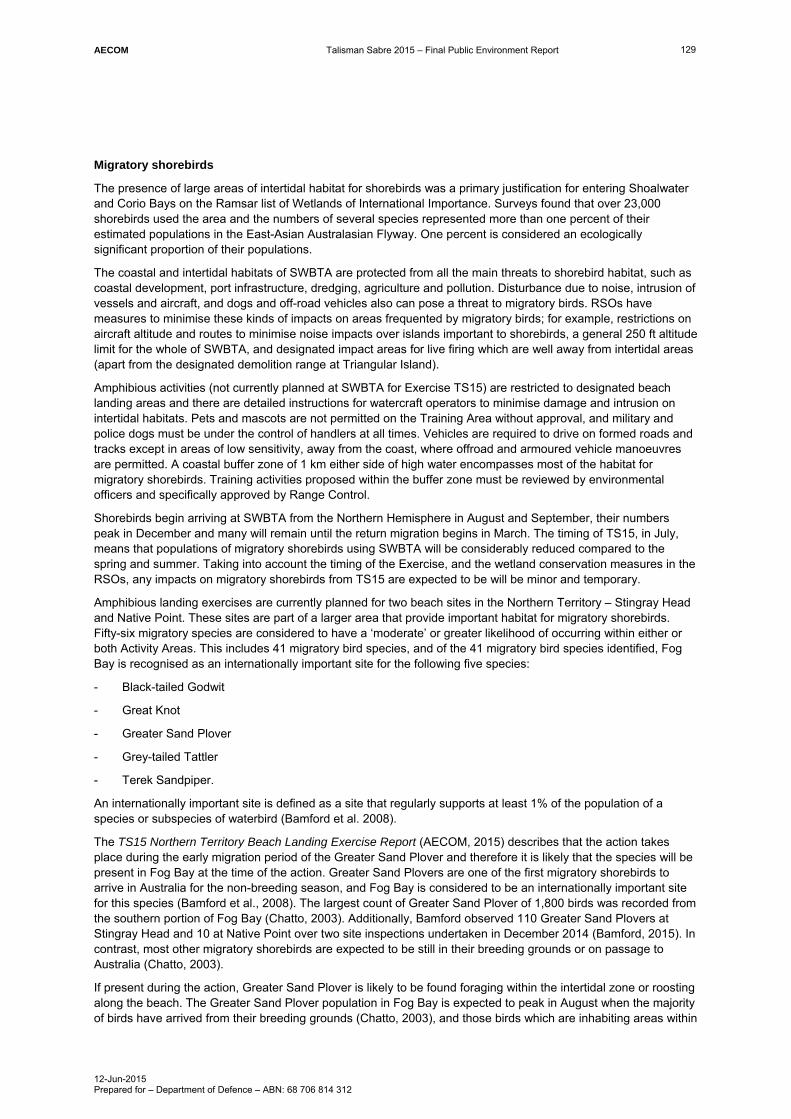
AECOM Talisman Sabre 2015 – Final Public Environment Report
12-Jun-2015 Prepared for – Department of Defence – ABN: 68 706 814 312
129
Migratory shorebirds
The presence of large areas of intertidal habitat for shorebirds was a primary justification for entering Shoalwater and Corio Bays on the Ramsar list of Wetlands of International Importance. Surveys found that over 23,000 shorebirds used the area and the numbers of several species represented more than one percent of their estimated populations in the East-Asian Australasian Flyway. One percent is considered an ecologically significant proportion of their populations.
The coastal and intertidal habitats of SWBTA are protected from all the main threats to shorebird habitat, such as coastal development, port infrastructure, dredging, agriculture and pollution. Disturbance due to noise, intrusion of vessels and aircraft, and dogs and off-road vehicles also can pose a threat to migratory birds. RSOs have measures to minimise these kinds of impacts on areas frequented by migratory birds; for example, restrictions on aircraft altitude and routes to minimise noise impacts over islands important to shorebirds, a general 250 ft altitude limit for the whole of SWBTA, and designated impact areas for live firing which are well away from intertidal areas (apart from the designated demolition range at Triangular Island).
Amphibious activities (not currently planned at SWBTA for Exercise TS15) are restricted to designated beach landing areas and there are detailed instructions for watercraft operators to minimise damage and intrusion on intertidal habitats. Pets and mascots are not permitted on the Training Area without approval, and military and police dogs must be under the control of handlers at all times. Vehicles are required to drive on formed roads and tracks except in areas of low sensitivity, away from the coast, where offroad and armoured vehicle manoeuvres are permitted. A coastal buffer zone of 1 km either side of high water encompasses most of the habitat for migratory shorebirds. Training activities proposed within the buffer zone must be reviewed by environmental officers and specifically approved by Range Control.
Shorebirds begin arriving at SWBTA from the Northern Hemisphere in August and September, their numbers peak in December and many will remain until the return migration begins in March. The timing of TS15, in July, means that populations of migratory shorebirds using SWBTA will be considerably reduced compared to the spring and summer. Taking into account the timing of the Exercise, and the wetland conservation measures in the RSOs, any impacts on migratory shorebirds from TS15 are expected to be will be minor and temporary.
Amphibious landing exercises are currently planned for two beach sites in the Northern Territory – Stingray Head and Native Point. These sites are part of a larger area that provide important habitat for migratory shorebirds. Fifty-six migratory species are considered to have a ‘moderate’ or greater likelihood of occurring within either or both Activity Areas. This includes 41 migratory bird species, and of the 41 migratory bird species identified, Fog Bay is recognised as an internationally important site for the following five species:
- Black-tailed Godwit
- Great Knot
- Greater Sand Plover
- Grey-tailed Tattler
- Terek Sandpiper.
An internationally important site is defined as a site that regularly supports at least 1% of the population of a species or subspecies of waterbird (Bamford et al. 2008).
The TS15 Northern Territory Beach Landing Exercise Report (AECOM, 2015) describes that the action takes place during the early migration period of the Greater Sand Plover and therefore it is likely that the species will be present in Fog Bay at the time of the action. Greater Sand Plovers are one of the first migratory shorebirds to arrive in Australia for the non-breeding season, and Fog Bay is considered to be an internationally important site for this species (Bamford et al., 2008). The largest count of Greater Sand Plover of 1,800 birds was recorded from the southern portion of Fog Bay (Chatto, 2003). Additionally, Bamford observed 110 Greater Sand Plovers at Stingray Head and 10 at Native Point over two site inspections undertaken in December 2014 (Bamford, 2015). In contrast, most other migratory shorebirds are expected to be still in their breeding grounds or on passage to Australia (Chatto, 2003).
If present during the action, Greater Sand Plover is likely to be found foraging within the intertidal zone or roosting along the beach. The Greater Sand Plover population in Fog Bay is expected to peak in August when the majority of birds have arrived from their breeding grounds (Chatto, 2003), and those birds which are inhabiting areas within

AECOM Talisman Sabre 2015 – Final Public Environment Report
12-Jun-2015 Prepared for – Department of Defence – ABN: 68 706 814 312
130
or close to the Activity Areas are expected to relocate to other parts of Fog Bay once the action has commenced, and return at the completion of the training activity.
Migratory waterbirds are likely to be found all year round in the Finniss River and its floodplains, including tidal creeks running along the back of the coastal dune system at both Activity Areas (Chatto, 2006). Any migratory waterbirds present within the Activity Areas are likely to relocate at the commencement of the action due to disturbances from noise and movement, and may not immediately return once the action is completed. However, any impacts are expected to be restricted to a relatively small percentage of the species habitat or population, and would not be considered a significant impact under the EPBC Act guidelines. Likewise, a significant impact to migratory seabirds that may be foraging within Fog Bay during the action is also unlikely for similar reasons.
In addition to the shorebirds, a large number of the migratory species such as whales, sharks, dolphins and some turtle and bird species are unlikely to be found within the NT amphibious beach landing Activity Areas (i.e. the intertidal zone, beach, coastal dunes, tidal creeks and hinterland) but may occur in offshore areas, and accordingly were assessed in the significant impact analysis.
The TS15 Northern Territory Beach Landing Exercise Report (AECOM, 2015) concluded that the action is unlikely to have a significant impact on migratory species within the Activity Areas, for one or more of the following reasons:
- the species is unlikely to be found within the Activity Areas during the action (e.g. still migrating from breeding grounds or returning to breeding grounds)
- the action is unlikely to have any impacts on the species’ habitat (e.g. Fog Bay or Finniss River and its floodplains)
- mitigation measures will be in place to reduce the risk of impacts to migratory species.
Turtles
Fog Bay is considered to be an important nesting site for Flatback Turtle (Chatto and Baker, 2008), and Olive Ridley is also likely to be nesting at Fog Bay (M. Guinea pers. comm., 23 September 2014). A number of other migratory turtle species use the shallow waters of Fog Bay as foraging grounds (NRETAS, 2014), and may be found feeding within the Activity Areas during the action. However, significant impacts to these species can be avoided because of limitations to the area of possible landing, the short duration of the action, and the risk mitigation measures that will be in place including controls on vessel speed, the pre-Exercise nest identification and relocation program, and controls on light-spill.
Nature and extent of likely impact
Considering the nature of TS15, the operational controls that will be in place and the ongoing stakeholder engagement to develop and refine specific management measures, there is little real chance or possibility that the military exercise will:
- substantially modify (including by fragmenting, altering fire regimes, altering nutrient cycles or altering hydrological cycles), destroy or isolate an area of important habitat for a migratory species
- result in an invasive species that is harmful to the migratory species becoming established in an area of important habitat for the migratory species, or
- seriously disrupt the lifecycle (breeding, feeding, migration or resting behaviour) of an ecologically significant proportion of the population of a migratory species.
7.1.7 Great Barrier Reef Marine Park
In recognition of the critical linkages between the conservation and other values of the Great Barrier Reef and the long-term sustainment of essential military activities in the region, Defence commissioned the Strategic Environmental Assessment of Defence Activities in the GBRWHA (URS Australia, 2006). The original 2006 assessment was updated in 2014 (Strategic Environmental Assessment of Defence Activities in the Great Barrier Reef World Heritage Area – PGM Environment & Ecological, 2014). Both of these strategic assessments were developed in close collaboration with GBRMPA and in consultation with other responsible agencies. The specific objectives for the Strategic Environmental Assessments (SEAs) were to:
- Provide comprehensive synopses of Defence interests, activities and capabilities in the GBRWHA

AECOM Talisman Sabre 2015 – Final Public Environment Report
12-Jun-2015 Prepared for – Department of Defence – ABN: 68 706 814 312
131
- Outline how those interests, activities and capabilities might impact upon the Great Barrier Reef’s values as a:
World Heritage property
National Heritage place
Matter of National Environmental Significance (MNES).
To achieve these objectives, both assessments:
- reviewed and evaluated Defence capabilities and activities applicable to the GBRWHA and contiguous areas (particularly the Coral Sea), and their potential environmental effects
- considered Defence activities in relation to applicable international conventions, and Australian legislation and policies
- evaluated management priorities and expectations for the GBRWHA
- identified key risk issues.
In terms of current activities (both training and operational), the Strategic Environmental Assessment of Defence Activities in the Great Barrier Reef World Heritage Area (PGM Environment & Ecological, 2014) found that Defence activities in the Great Barrier Reef do pose some risks of adverse environmental outcomes, the most significant of which were the possibility of introducing potential marine pests through hull biofouling, and the possibility of explosive demolitions training impacting on marine species such as turtle, Dugong or inshore dolphin. However, it was concluded that Defence posed no substantive risk to the ecological integrity and/or function of the Great Barrier Reef, or to the values of the GBRWHA. A number of species, communities and locations were noted to specifically benefit from the protection afforded as a result of the Defence presence in the Great Barrier Reef, most notably at Shoalwater Bay.
With respect to explosive demolitions training, this is not planned for TS15. Nonetheless, Defence is currently conducting fauna monitoring, including turtle tracking, in the Great Barrier Reef Marine Park in order to better understand the risk to marine species as a result of explosive demolitions activities sometimes conducted at Triangular Island.
Of specific relevance to TS15 were the Strategic Environmental Assessment findings that:
- The impacts of major exercises such as TS15 are predictable and expected to be localised, minor and recoverable, given the tested and effective risk avoidance and impact mitigation measures which are routinely employed for exercises.
- While the scale, tempo and frequency of Defence activities in the Great Barrier Reef is expected to increase, the frequency and size of major Defence training activities is not predicted to change to any great extent. This is based upon the field training capacity of the land elements of Shoalwater Bay which has a ceiling on the number of troops and supporting elements able to conduct training exercises effectively at any one time (as well as the frequency of such large scale exercises).
- While sewage discharges in the Great Barrier Reef from RAN and visiting warships were unlikely to have any long-term, significant effect on ecological values, further research and monitoring would be prudent, possibly leading to the development and adoption of further controls particularly around the SWBTA and CBTA. For example, these controls may include designated anchorage zones within which treated effluent discharges would be less likely to result in localised adverse effects.
The Great Barrier Reef Outlook Report 2014 included an independent assessment of management effectiveness. The independent assessment found that Defence activities were limited in area and duration and the social, biophysical and jurisdictional management issues were minor. The authors considered that management challenges were evident for issues that are complex and broad in scale and therefore effectiveness is strongest for issues that are limited in scale and complexity, such as Defence and scientific research. The report concluded that ‘the limited area of operations and the high level of performance in minimising the environmental impacts results in Defence activities posing minimal threat to Great Barrier Reef values.’
As with previous large Defence exercises in the Great Barrier Reef Marine Park, GBRMPA has been involved in planning and will be involved in management of TS15 in line with the 2008 Management Agreement between Defence and GBRMPA.
Table 28 provides a self-assessment against the general assessment criteria for Great Barrier Reef Marine Park, as provided in Significant Impact Guidelines 1.1 Matters of National Environmental Significance. Overall, TS15 is not predicted to have a significant impact on the Great Barrier Reef Marine Park.

AECOM Talisman Sabre 2015 – Final Public Environment Report
12-Jun-2015 Prepared for – Department of Defence – ABN: 68 706 814 312
132
Table 28 Self-assessment of potential for significant impact on Great Barrier Reef Marine Park
Criterion – ‘Is there a real chance or possibility that Exercise TS15 will…’
Assessment of nature and extent of impacts
Modify, destroy, fragment, isolate or disturb an important, substantial, sensitive or vulnerable area of habitat or ecosystem component such that an adverse impact on marine ecosystem health, functioning or integrity in the Great Barrier Reef Marine Park results?
Unlikely.
TS15 proposes a range of training activities that are well understood, have been conducted before, and for which there are established environmental management controls and procedures.
The 2014 Strategic Environmental Assessment found that Defence posed no substantive risk to the ecological integrity and/or function of the Great Barrier Reef, and as such it is considered unlikely that TS15 have any impacts to such values.
Have a substantial adverse effect on a population of a species or cetacean including its life cycle (for example, breeding, feeding, migration behaviour, life expectancy) and spatial distribution?
No.
TS15 is scheduled during the migration period for Humpback Whales, and while there is some potential for TS15 activities to interact with and/or disturb a small number of whales for a short period, it is considered highly unlikely that these activities would disrupt the breeding process or result in any other substantial impacts.
Stringent measures to avoid impacts on marine cetaceans have been developed as part the Maritime Activities EMP and are used during training exercises. There are several Procedure Cards for operation of sensor systems, including operation of Anti-Submarine Warfare active sonars, towed array sonars, minehunting sonars, mine and obstacle avoidance sonars, hydrographic survey sonars, diver operated sonars, active sonobuoys and miscellaneous active sonars. In international waters, the US Navy has strict procedures that apply to the systems that are fitted to US Navy ships.
Result in a substantial change in air quality or water quality (including temperature) which may adversely impact on biodiversity, ecological health or integrity or social amenity or human health?
No.
TS15 proposes a range of training activities that are well understood, have mostly been conducted before, and for which there are established environmental management controls and procedures.
Exercise instructions will specify management of various forms of waste by vessels. Locations for any authorised discharges will be broadly consistent with arrangements for commercial shipping. Discharge ‘boxes’ are specified within the GBRMP given the higher level of environmental values in this area. Areas where discharges are not permitted in waters off NT are charted.
Any hazardous wastes generated by warships will be contained within these ships and will not be discharged at sea, which is in accordance with Basel Convention obligations.
When considered in the context of existing agricultural and industrial activities adjacent to the Great Barrier Reef Marine Park, any impacts on water quality would be negligible and recoverable. Any changes to air quality would also be short in duration and are not expected to have any impact on biodiversity, ecological health, social amenity or human health.

AECOM Talisman Sabre 2015 – Final Public Environment Report
12-Jun-2015 Prepared for – Department of Defence – ABN: 68 706 814 312
133
Criterion – ‘Is there a real chance or possibility that Exercise TS15 will…’
Assessment of nature and extent of impacts
Result in a known or potential pest species being introduced or becoming established in the Great Barrier Reef Marine Park?
Unlikely.
The Maritime Activities EMP has specific guidance and instructions to minimise the risk of marine pests, such as ballast water uptake and discharge, transfer of cargo, cleaning of small boats and trailers and movement of equipment between marine areas.
All foreign visitors, including US Military personnel, must comply with Biosecurity requirements and specific quarantine controls and inspections apply to all vessels, aircraft and equipment being introduced into Australia including those proposed for use during TS15. As for previous exercises, Department of Agriculture biosecurity officers will travel to offshore locations to pre-inspect US military equipment prior to arriving in Australia for the Exercise.
Result in persistent organic chemicals, heavy metals, or other potentially harmful chemicals accumulating in the marine environment such that biodiversity, ecological integrity, or social amenity or human health may be adversely affected?
No.
Refer to the assessment under the above criterion relating to changes in air quality or water quality.
Have a substantial adverse impact on heritage values of the Great Barrier Reef Marine Park, including damage or destruction of an historic shipwreck?
Unlikely.
Impacts from TS15 are expected to be localised, temporary and recoverable. When considered in the context of Defence’s sound track record of collaborative management with GBRMPA, standard Defence controls such as RSOs, Maritime Activities EMP and buffer zones, and exercise-specific controls such as the TS15 EMP, it is considered unlikely that TS15 will result in degradation or damage of the heritage values of the Great Barrier Reef Marine Park.
7.1.8 Nuclear actions
Neither TS15 in aggregate, nor any of the sub elements of the Exercise, could be considered a nuclear action as defined in Section 22 of the EPBC Act.
Nuclear powered submarines and nuclear powered aircraft carriers of the US military will participate in TS15. Routine radiation testing will be undertaken at ports visited by nuclear powered vessels before, during and after TS15. Members of the US Navy operating nuclear powered vessels have a high record of safety and professionalism.
Nuclear weapons and depleted uranium munitions will not be used during TS15. Depleted uranium munitions are not part of the ADF inventory of equipment or supplies and are not permitted to be used by foreign forces in Australia.
7.1.9 The Commonwealth marine environment
The Commonwealth marine environment refers to the environment in a Commonwealth marine area. The Commonwealth marine area is any part of the sea, including the waters, seabed, and airspace, within Australia's exclusive economic zone and/or over the continental shelf of Australia, that is not State or Northern Territory waters. The Commonwealth marine area stretches from 3 to 200 nautical miles from the coast.
The Commonwealth marine environment is a matter of national environmental significance under the EPBC Act. An action will require approval if the: action is taken in a Commonwealth marine area and the action has, will have, or is likely to have a significant impact on the environment; or the action is taken outside a Commonwealth marine area and the action has, will have, or is likely to have a significant impact on the environment in a Commonwealth marine area. While this MNES does not apply to the Commonwealth, it contains the same requirement contained under section 28 of the EPBC Act to seek approval for activities that have, will have or are

AECOM Talisman Sabre 2015 – Final Public Environment Report
12-Jun-2015 Prepared for – Department of Defence – ABN: 68 706 814 312
134
likely to have a significant impact on the environment. For the sake of completeness however, this PER has considered this MNES.
North Marine Region
TS15 activities that occur within the Timor and Arafura Seas will fall within the North Marine Region. The North Marine Region comprises Commonwealth waters from west Cape York Peninsula to the Northern Territory–Western Australia border. The region covers approximately 625, 689 square kilometres of tropical waters in the Gulf of Carpentaria and Arafura and Timor seas, and abuts the coastal waters of Queensland and the Northern Territory. The North Marine Region is governed by a Bioregional Plan, prepared pursuant to the EPBC Act (DSEWPaC, 2012a). The plan does not cover state or territory waters but, where relevant, does include information about inshore environments and the way they interact with species and habitats of the Commonwealth marine area.
The Plan identifies a range of conservation values in the North Marine Region, comprising eight key ecological features, species listed under Part 13 of the EPBC Act that live in the North Marine Region and biologically important areas and protected places including marine reserves, heritage places and historic shipwrecks.
A pressure analysis for the North Region identified that the highest potential for environmental pressure in the North Marine Region relates to climate change and associated large-scale effects, harvesting of living resources, increasing industrial development in areas adjacent to the region, and growth in marine industries and infrastructure (DSEWPaC, 2012a). Further information was presented in Section 5.10 of this report.
Coral Sea Commonwealth Marine Reserve
The Coral Sea Commonwealth Marine Reserve encompasses the former Coral Sea Conservation Zone, former Coringa-Herald National Nature Reserve and former Lihou Reef National Nature Reserve. Covering an area of 989,842 km2 adjacent to the Great Barrier Reef Marine Park, the new reserve will provide a greater level of protection to the conservation and heritage values of the area. The Marine Reserve will have six zones with varying levels of protection from general use including tourism, aquaculture and some commercial fishing, to strictly protected ‘no-take’ nature reserves. However, at present there is no management plan in place for this reserve, meaning that until a management plan comes into effect transitional management arrangements for the Coral Sea Conservation Zone, Coringa-Herald National Nature Reserve and Lihou Reef National Nature Reserve apply.
In framing the reserve proposal, the Commonwealth Government considered the central role played by Defence in managing Australia’s offshore marine areas and island territories through surveillance, hydrographic survey, transport, search and rescue, and where required, deterrence and enforcement. The Commonwealth Government also recognised that training exercises may require naval and aircraft manoeuvres and transit through marine protected areas. Accordingly, all six zones in the Coral Sea Commonwealth Marine Reserve will permit Defence activities.
The Maritime Area EMP and Air Operations EMP provide extensive information and guidance to the ADF to avoid and mitigate environmental impacts from training and operations in marine areas. In addition, exercise areas have been designated for military training in the Commonwealth Marine Area, in open ocean sites that are remote from sensitive places and marine protected areas.
Table 29 provides a self-assessment against the general assessment criteria for The Commonwealth marine environment, as provided in Significant Impact Guidelines 1.1 Matters of National Environmental Significance. Overall, TS15 is not predicted to have a significant impact on the Commonwealth marine environment.
Table 29 Self-assessment of potential for significant impact on the Commonwealth marine environment
Criterion – ‘Is there a real chance or possibility that Exercise TS15 will…’
Assessment of nature and extent of impacts
Result in a known or potential pest species becoming established in the Commonwealth marine area?
Unlikely.
The Maritime Activities EMP has specific guidance and instructions to minimise the risk of marine pests, such as ballast water uptake and discharge, transfer of cargo, cleaning of small boats and trailers and movement of equipment between marine areas.

AECOM Talisman Sabre 2015 – Final Public Environment Report
12-Jun-2015 Prepared for – Department of Defence – ABN: 68 706 814 312
135
Criterion – ‘Is there a real chance or possibility that Exercise TS15 will…’
Assessment of nature and extent of impacts
All foreign visitors, including US Military personnel, must comply with Biosecurity requirements and specific quarantine controls and inspections apply to all vessels, aircraft and equipment being introduced into Australia including those proposed for use during TS15. As for previous exercises, Department of Agriculture biosecurity officers will travel to offshore locations to pre-inspect US military equipment prior to arriving in Australia for the Exercise.
Modify, destroy, fragment, isolate or disturb an important or substantial area of habitat such that an adverse impact on marine ecosystem functioning or integrity in a Commonwealth marine area results?
No.
Noting that TS15 will take place over a short period in the Commonwealth marine area(s), that comprehensive environmental assessment and mitigation has been implemented through the Maritime Area EMP and Air Operations EMP, and that actions in the GBRWHA are managed in consultation with the GBRMPA, it is considered that any impact on habitat values will be negligible and transient as military aircraft and vessels pass through.
Have a substantial adverse effect on a population of a marine species or cetacean including its life cycle and spatial distribution?
Unlikely.
TS15 is scheduled during the migration period for Humpback Whales, and while there is some potential for TS15 activities to interact with and/or disturb a small number of whales for a short period, stringent measures to avoid impacts (refer to Section 6.7.5) are used during training exercises. As such, it is considered highly unlikely that these activities would disrupt the breeding process or result in any other substantial impacts.
Given the short-term nature of TS15, any lasting impacts on the viability of other marine species populations are also unlikely. However, as the planned NT beach landing sites at Fog Bay are known to be important for Flatback Turtle nesting (June to August is a key nesting period), additional environmental assessment will be undertaken prior to approval of these locations for use in TS15. This assessment, which forms part of the Defence environmental impact assessment process, must be followed before any location can be gazetted as a Defence Practice Area.
Result in a substantial change in air quality or water quality (including temperature) which may adversely impact on biodiversity, ecological integrity; social amenity or human health?
No.
Exercise instructions will specify management of various forms of waste by vessels. Locations for any authorised discharges will be broadly consistent with arrangements for commercial shipping. Discharge ‘boxes’ are specified within the GBRMP given the higher level of environmental values in this area. Areas where discharges are not permitted in waters off NT are charted.
Any hazardous wastes generated by warships will be contained within these ships and will not be discharged at sea, which is in accordance with Basel Convention obligations.
Overall, air and water quality impacts associated with TS15 will be minor, temporary, and recoverable, and are not expected to have any impact on biodiversity, ecological health, social amenity or human health.
Result in persistent organic chemicals, heavy metals, or other potentially harmful chemicals accumulating in the marine environment such that biodiversity, ecological integrity, social amenity or human health may be adversely affected
No.
Refer to the reasoning provided for the criterion relating to changes in air quality or water quality.

AECOM Talisman Sabre 2015 – Final Public Environment Report
12-Jun-2015 Prepared for – Department of Defence – ABN: 68 706 814 312
136
Criterion – ‘Is there a real chance or possibility that Exercise TS15 will…’
Assessment of nature and extent of impacts
Have a substantial adverse impact on heritage values of the Commonwealth marine area, including damage or destruction of an historic shipwreck?
Unlikely.
Impacts from TS15 are expected to be localised, temporary and recoverable. When considered in the context of Defence’s sound track record of collaborative management with relevant agencies, standard Defence controls such as the Maritime Activities EMP and buffer zones, and exercise-specific controls such as the TS15 EMP, it is considered unlikely that TS15 will result in degradation or damage of the heritage values of the Commonwealth marine area.
7.1.10 Protection of water resources from coal seam gas development and large coal mining development
Not applicable to Exercise TS15.
7.2 The whole of environment on Commonwealth land or by a Commonwealth agency action
As TS15 is proposed to be undertaken by a Commonwealth agency and to utilise Commonwealth land, it is also necessary to consider the potential for significant impact on ‘the environment’, as defined in Section 528 of the EPBC Act, specifically:
a) ecosystems and their constituent parts including people and communities (‘ecosystem’ is defined in the EPBC Act as ‘a dynamic complex of plant, animal and micro-organism communities and their non-living environment interacting as a functioning unit’)
b) natural and physical resources
c) qualities and characteristics of locations, places and areas
d) heritage values of places (‘heritage value’ is defined in the EPBC Act as including ‘the place’s natural and cultural environment having aesthetic, historic, scientific or social significance, or other significance, for current and future generations of Australians.’ ‘Indigenous heritage value’ is defined as meaning ‘a heritage value of the place that is of significance to Indigenous persons in accordance with their practices, observances, customs, traditions, beliefs or history’), and
e) the social, economic and cultural aspects of a thing mentioned in paragraphs a, b or c.
Potential impacts of TS15 have been described in Section 5.0 of this PER. Outside the Defence training areas, most of the Exercise activities vary little from civilian uses such as road, ship and aircraft transit along established transport routes, entry to ports and airports, and disembarking and embarking personnel and cargo. Components of the activity that may have higher impacts, such as live firing and armoured vehicle manoeuvre, are restricted to Defence Training Areas and Gazetted Defence Practice Areas.
In order to determine the potential for TS15 activities to result in a significant impact to the environment, a self-assessment against the general assessment criteria provided in Significant Impact Guidelines 1.2 Actions on, or impacting upon, Commonwealth land, and actions by Commonwealth agencies has been carried out and the results presented in Table 30. Overall, TS15 is not predicted to have a significant impact on the environment as defined in Section 528 of the EPBC Act.

AECOM Talisman Sabre 2015 – Final Public Environment Report
12-Jun-2015 Prepared for – Department of Defence – ABN: 68 706 814 312
137
Table 30 Self-assessment of potential for significant impact on the environment as a result of actions on, or impacting upon, Commonwealth land, and actions by Commonwealth agencies
Criterion – ‘Is there a real chance or possibility that Exercise TS15 will…’
Assessment of nature and extent of impacts
Landscapes and soils
Substantially alter natural landscape features?
No.
Exercise TS15 will involve some localised excavation for activities such as establishment of temporary infrastructure (where possible existing infrastructure will be used), field engineering and road cratering; however, these activities routinely occur on training areas and will not substantially alter natural landscape features.
Some air-to-ground live firing exercises would be conducted as part of TS15 over existing Gazetted Defence Practice Areas such as DRF, which have been specifically set aside for such activities and the impacts assessed as part of their establishment. Mitigation measures such as reinstatement by DAMCON personnel will also be in place for the Exercise.
Cause subsidence, instability or substantial erosion?
Unlikely.
While the PER has identified the potential for some erosion to occur as a result of off-road vehicle movements, the extent is unlikely to be substantial and would be confined to established Training Areas which are managed in accordance with Training Area SMRPs.
Off-road movements will be controlled by exercise instructions and SOs, and areas of erosion or soil compaction would be identified during post- exercise monitoring and rehabilitated if necessary. Specific resources, such as DAMCON are available for this during the Exercise.
Involve medium or large-scale excavation of soil or minerals?
No.
While TS15 will involve some localised excavation for activities such as establishment of temporary infrastructure (where possible existing infrastructure will be used), field engineering and road cratering at SWBTA, medium or large scale excavation is not proposed.
Coastal landscapes and processes
Alter coastal processes, including wave action, sediment movement or accretion, or water circulation patterns?
Unlikely.
While the PER has identified the potential for amphibious landing exercises planned for two NT beaches (and potentially SWBTA) to cause some short-term damage to beach substrate, it is highly unlikely that any activities associated with TS15 would alter coastal processes.
Permanently alter tidal patterns, water flows or water quality in estuaries?
No.
TS15 is a series of military exercises conducted over a limited time period. No activities with the potential to permanently alter tidal patterns or water flows in estuaries are proposed.
This PER has identified the potential for short-term adverse impacts on water quality due to accidental spills from small vessels; however, any such spills are likely to be small and resultant impacts short in duration. Spill materials will be carried by vessels. Additionally, SOs prohibit activities with a potential to result in contamination (e.g. latrines or refuelling) within 100 m of a creek.
Navy vessels are required to discharge waste materials in open ocean, and as such, impacts on water quality of estuaries are highly unlikely.

AECOM Talisman Sabre 2015 – Final Public Environment Report
12-Jun-2015 Prepared for – Department of Defence – ABN: 68 706 814 312
138
Criterion – ‘Is there a real chance or possibility that Exercise TS15 will…’
Assessment of nature and extent of impacts
Reduce biological diversity or change species composition in estuaries?
No.
Biological diversity at estuarine locations (SWBTA, CBTA) would not be reduced as a result of TS15. Proposed activities are short in duration, consistent with existing use as Defence training areas, and would occur in the context of ongoing sustainable training area management practices in place. Additionally, the applicable controls described above further protect biological diversity and species composition.
Extract large volumes of sand or substantially destabilise sand dunes?
No.
TS15 would require vehicle manoeuvre in the coastal zone on the beaches and adjacent dunes used for amphibious landings (NT – Stingray Head, Native Point; QLD – SWBTA). While these exercises do have some potential to result in minor destabilisation of sand dunes if conducted inappropriately, control measures are in place to avoid and/or mitigate impacts a significant impact is unlikely. Controls include:
- A specific environmental assessment is being conducted at proposed beach landing sites
- Vehicle operation in accordance SOs for Vehicle Operators
- ECC process to identify and stipulate no-go areas where dunes are deemed to be vulnerable
- Post-exercise environmental monitoring and rehabilitation by DAMCON personnel where required.
TS15 would not require extraction of large volumes of sand.
Ocean forms, ocean processes and ocean life
Reduce biological diversity or change species composition on reefs, seamounts or in other sensitive marine environments?
Unlikely.
TS15 includes maritime activities and aircraft operations over water. While there is some potential for incidental impacts on marine flora and fauna through an accident such as a ship grounding, state of the art navigation systems, very high competency levels and strict procedures reduce the likelihood of occurrence to a very low level. There is little to no potential to alter species composition on reefs, seamounts or in other sensitive marine environments.
The potential for the suite of Defence activities in the GBRWHA as opposed to one exercises) to result in significant impacts has been considered in the Strategic Environmental Assessment of Defence Activities in the Great Barrier Reef World Heritage Area (PGM Environment & Ecological, 2014). The assessment concluded that, on balance, Defence presence in the GBRWHA has an effectively neutral to positive effect upon the environmental values that contribute to its World Heritage listing.
Alter water circulation patterns by modification of existing landforms or the addition of artificial reefs or other large structures?
No.
No activities that would result in this impact will take place as part of TS15.

AECOM Talisman Sabre 2015 – Final Public Environment Report
12-Jun-2015 Prepared for – Department of Defence – ABN: 68 706 814 312
139
Criterion – ‘Is there a real chance or possibility that Exercise TS15 will…’
Assessment of nature and extent of impacts
Substantially damage or modify large areas of the seafloor or ocean habitat, such as seagrass
Unlikely.
TS15 includes maritime activities and aircraft operations over water. While there is some potential for incidental impacts on benthic habitat due to a ship grounding accident, this is considered highly unlikely to occur.
Consideration has been given to the potential for ship wastewater discharge to impact upon existing seagrass beds. Specific discharge areas (for use when no alternative is available) have been defined for the GBRMPA away from potentially sensitive receptors. Locations have been developed and refined in conjunction with the GBRMPA. When the number of vessel movements associated with TS15 is considered in the context of routine merchant shipping movements in the Coral, Timor, and Arafura Seas, as well as existing discharge levels from land-based enterprises, the potential for significant impact on the health of the seafloor or ocean habitat as a result of TS15 is considered unlikely.
Exercise instructions will specify management of various forms of waste by vessels. Locations for any authorised discharges will be broadly consistent with arrangements for commercial shipping. Discharge ‘boxes’ are specified within the GBRMP given the higher level of environmental values in this area. Areas where discharges are not permitted in waters off NT are charted.
Release oil, fuel or other toxic substances into the marine environment in sufficient quantity to kill larger marine animals or alter ecosystem processes
Unlikely.
The risk of pollution from maritime activities is reduced through adherence to SOPs and the application of Maritime Activities EMP Procedure Cards. These provide guidance on risk reduction for marine pollution for specific activities. Guidance includes sea disposal of garbage, sewage and oily wastes and replenishment at sea. These procedures are among the most stringent in the world. In addition, any spill greater than 20 L (5 L within the GBRMP) must be reported and information on procedures provided. This includes information on response resources, both military and civilian that can respond to a spill and how quickly.
While emergency aerial fuel dumping may occur during TS15, this is unlikely to result in measurable ground deposition, due to the dispersion and turbulence from the aircraft flight, and the volatilisation that would occur prior to the fuel reaching the ground. Standard practice is to conduct any emergency fuel dumping at a high altitude (e.g. above 6,000 ft).
Any hazardous wastes generated by warships will be contained within these ships and will not be discharged at sea, which is in accordance with Basel Convention obligations. Nuclear powered warships do not generate any radioactive waste.
Release large quantities of sewage or other waste into the marine environment?
Unlikely.
Exercise instructions will specify management of various forms of waste by vessels. Locations for any authorised discharges will be broadly consistent with arrangements for commercial shipping. Discharge ‘boxes’ are specified within the GBRMP given the higher level of environmental values in this area. Areas where discharges are not permitted in waters off NT are charted.
Any hazardous wastes generated by warships will be contained within these ships and will not be discharged at sea as specified in accordance with Basel Convention obligations.
Discharge of garbage within the Great Barrier Reef Marine Park is prohibited and dumping of ‘blackwater’ (sewage) is only allowed in exceptional circumstances in areas designated by the GBRMPA specifically for the Exercise.

AECOM Talisman Sabre 2015 – Final Public Environment Report
12-Jun-2015 Prepared for – Department of Defence – ABN: 68 706 814 312
140
Criterion – ‘Is there a real chance or possibility that Exercise TS15 will…’
Assessment of nature and extent of impacts
Water resources
Measurably reduce the quantity, quality or availability of surface or ground water?
Unlikely.
There is some potential for field activities and encampments to have some adverse effects on water quality during the Exercise period. However, these potential impacts are controlled through RSOs, including site-specific restrictions on the location of field camps, administrative/maintenance, refuelling areas, portable toilets or latrines, disposal of grey water or burying of human waste, in proximity to watercourses (e.g. a 200m buffer is in place at MBTA).
Annual water quality monitoring is conducted at MBTA, Bradshaw Field Training Area, SWBTA, TFTA and CBTA. During the Exercise TS15, additional monitoring will be undertaken by the TS15 EMG.
Limited groundwater extraction from bores may occur in some locations; however, given the short duration of the Exercise, this is unlikely to result in a measurable reduction in the availability of groundwater. Surface water abstraction is not carried out at any of the training areas.
Channelise, divert or impound rivers or creeks or substantially alter drainage patterns?
No.
This is not planned for Exercise TS15.
Measurably alter water table levels?
Unlikely.
Limited groundwater extraction from bores may occur in some locations; however, given the short duration of the Exercise, this is unlikely to result in a measurable reduction in the availability of groundwater. Surface water abstraction is not carried out at any of the training areas.
Plants
Medium or large-scale native vegetation clearance?
Unlikely.
While some vegetation clearance may be required for establishment and maintenance of target areas and gun positions, this is expected to be minor in scale. There is also some potential for damage to native vegetation as a result of off-road vehicle movements and maintenance of existing tracks (e.g. lopping of overhanging branches), but this is also not considered to be medium or large in scale.
RSOs prescribe that disturbance to vegetation, and the environment in general, should be minimised to reduce the likelihood of detection by a potential enemy. In addition, RSOs also provide measures to minimise direct disturbance to vegetation and wildlife across the training area, including:
- restricting the felling of trees and saplings
- restricting the clearance of flora
- prohibiting indiscriminate damage to, or wilful destruction of, flora
- restricting vehicle movement
- prohibiting attachment of targets to trees (or use of trees as targets)
- measures to ensure trees are protected from any ropes or signs that may need to be attached
- prohibiting the removal of native plants from the training area
- minimising the use and disturbance of mangrove and foreshore vegetation.

AECOM Talisman Sabre 2015 – Final Public Environment Report
12-Jun-2015 Prepared for – Department of Defence – ABN: 68 706 814 312
141
Criterion – ‘Is there a real chance or possibility that Exercise TS15 will…’
Assessment of nature and extent of impacts
Clearance of any vegetation containing a listed threatened species which is likely to result in a long-term decline in a population or which threatens the viability of the species?
Unlikely.
For Defence Training Areas, RSOs specify ‘restricted areas’ in order to conserve identified threatened species and habitat. Any vegetation clearance is likely to be minor and will not be permitted in known areas of listed threatened species habitat through the ECC process.
Introduce potentially invasive species?
Unlikely.
Preventing the introduction and dispersal of weeds through control of weed infestations is carried out across the Defence Estate. Information on preventing introduction and dispersal is provided to personnel by environmental awareness cards and weed prevention activities are specified in RSOs. Additionally vehicle hygiene facilities including dedicated wash bays are located at training areas, Barracks and other Defence facilities.
The PER has identified the potential for dispersal of weeds and pathogens between activity locations as a key risk during TS15; however, the risk has been managed in the past through measures including:
- Inspection of ADF, NZ and US Armed Forces vehicles prior to entry and departure to training areas. This includes the cleaning of all vehicles (including contractor vehicles), equipment and vehicle loads prior to entry into the training area at wash-down facilities.
- Vehicles, boots, plant and equipment must also be clean and free from contaminants.
- Demarcation of ‘restricted areas’ where access is restricted due to safety, heritage or environmental values or threats. For example areas of weed infestation are clearly marked on maps and signposted as ‘restricted areas’ to prevent dispersal.
- Washdown of rotary wing aircraft prior to transit between training areas.
- Weed surveys are regularly conducted and weed management plans developed that include recommendations for management and priority areas for control.
The implementation of these safeguards during TS15 will minimise the likelihood of introducing additional weed risks.
Substantially stunt growth of native species through the use of chemicals or undertake any controlled burning in sensitive areas?
No.
While controlled burning and use of herbicides may occur as part of general Defence training area weed and fire risk management, these activities are not proposed specifically for TS15.
Animals
Cause a long-term decrease in, or threaten the viability of, a native animal population/s, through death, injury or other harm to individuals?
Unlikely.
While there is some potential for direct injury or death of individual animals due to vehicle, vessel or aircraft collision, the levels of activity and controls in place are such that this is unlikely to result in a long-term decrease in, or threaten the viability of, a species population.
Displace or substantially limit the movement or dispersal of native animal populations?
No.
While TS15 activities (e.g. presence of increased numbers of troops, amphibious landing exercises) may temporarily disrupt some native fauna and affect movement patterns, this would be very short-term, localised and impacts recoverable.

AECOM Talisman Sabre 2015 – Final Public Environment Report
12-Jun-2015 Prepared for – Department of Defence – ABN: 68 706 814 312
142
Criterion – ‘Is there a real chance or possibility that Exercise TS15 will…’
Assessment of nature and extent of impacts
Substantially reduce or fragment available habitat for native species?
No.
Areas proposed for use in TS15, including SWBTA, CBTA and MBTA are known to support a range of native species, including listed threatened species. However, the activities proposed for TS15 are likely to result in only minor clearance of native vegetation; therefore, substantial reduction or fragmentation of native species habitat will not occur.
Reduce or fragment available habitat for listed threatened species which is likely to displace a population, result in a long-term decline in a population, or threaten the viability of the species?
Unlikely.
Areas proposed for use in TS15, including SWBTA, CBTA and BFTA are known to support a range of native species, including listed threatened species discussed in Section 7.1.
In terms of terrestrial fauna species, activities proposed for TS15 require only minor clearance of native vegetation; therefore, substantial reduction or fragmentation of native species habitats, and resultant impacts on species viability, is considered unlikely.
SWBTA, CBTA and the proposed NT beach landing sites also provide important habitat for listed threatened turtle species, including Loggerhead, Leatherback, Olive Ridley and Flatback turtles. While the PER has identified the potential for amphibious landing exercises to cause some impacts to beach substrate and benthic flora on approaches to the landing sites, these impacts are expected to be minor and reversible, and not result in any discernible decline in population numbers of species viability.
Introduce exotic species which will substantially reduce habitat or resources for native species?
Unlikely.
Preventing the introduction and dispersal of weeds through control of weed infestations is carried out across the Defence estate. Information on preventing introduction and dispersal is provided to personnel by environmental awareness cards and weed prevention activities are specified in RSOs. Additionally vehicle hygiene facilities including dedicated wash bays are located at training areas, barracks and other Defence facilities.
Pest insect species such as Red Imported Fire Ant do occur at certain training areas, bases and ports (e.g. Gladstone), and there is some risk of such species being transported between sites. Safeguards will be implemented to minimise the spread of introduced terrestrial fauna species, including vehicle cleaning, targeted pest control and ‘no-go zones).
It is considered unlikely that TS15 will result in the introduction of new exotic terrestrial fauna species into Australian training areas. All foreign visitors, including US Military personnel, must comply with biosecurity requirements and specific quarantine controls and inspections apply to all vessels, aircraft and equipment being introduced into Australia including those proposed for use during TS15. The Commonwealth Department of Agriculture has established guidelines and resources for administering quarantine for ADF and foreign military activities, which is managed by the National Coordination Centre – Military. As occurred during the previous TS13 exercise, Biosecurity officers will travel to offshore locations to pre-inspect US military equipment prior to arriving in Australia for the Exercise.
People and communities
Substantially increase demand for, or reduce the availability of, community services or infrastructure which have direct or indirect impacts on the environment,
Unlikely.
With respect to activities proposed in Queensland, the overall scale is expected to be smaller than TS13. While previous exercises resulted in temporarily increased demand for some infrastructure proximate to the Exercise areas (e.g. Rockhampton), post-exercise reports do not indicate that this resulted in a reduced availability of these services to the community.

AECOM Talisman Sabre 2015 – Final Public Environment Report
12-Jun-2015 Prepared for – Department of Defence – ABN: 68 706 814 312
143
Criterion – ‘Is there a real chance or possibility that Exercise TS15 will…’
Assessment of nature and extent of impacts
including water supply, power supply, roads, waste disposal, and housing?
The scale of activities in NT Training Areas, Darwin Port, RAAF Base Darwin and Gazetted Defence Practice Areas is proposed to be greater than TS13. To support the increased numbers of ADF and USMC personnel present during the activity, exercise planning will consider the need for additional resources (e.g. temporary generators, camp sites) to ensure the self-sufficiency of Training Areas and Bases. TS15 will generate some increased demand for civilian accommodation (e.g. hotel rooms) during, and in the weeks preceding and following the Exercise; however, the impact of this increased demand will be temporary, reversible, and will also result in some economic benefits for local businesses.
Affect the health, safety, welfare or quality of life of the members of a community, through factors such as noise, odours, fumes, smoke, or other pollutants?
Unlikely.
While localised increases in noise, dust and odours may be experienced as a result of TS15 activities, arising for example through military convoy vehicle movements on public roads, such effects would be short-lived and generally remote from densely populated areas. Safeguards exist in SOPs to avoid and minimise the extent of dust generation, with dust suppression measures implemented where required.
While there is some potential for bushfires to occur as a result of activities such as firing of live ammunition, use of explosives and off road vehicle manoeuvres, Defence has current SOPs for the training areas involved in TS15. Management includes periodic hazard reduction burning to reduce the level of fuel loads, as well as the construction and maintenance of fire breaks. The activities are planned for the early dry season when risk of fires is much lower than later in the year.
Noise impacts on sensitive receivers may also be generated by low altitude flight, particularly around RAAF Base Darwin and RAAF Base Tindal. These are operational air bases which result in ongoing noise. Noise levels and durations are unlikely to exceed other regular exercises carried out at other times of the year such as Exercise Pitch Black and is considered to be unlikely to result in reduction of the health, safety, welfare or quality of life in the community.
Cause physical dislocation of individuals or communities?
No.
While TS15 may require temporary closure of recreational areas sometimes used by the general public (e.g. Stingray Head, Native Point, Cowley Beach, Darwin Showgrounds, DRF), this will not result in physical dislocation of individuals or communities.
Substantially change or diminish cultural identity, social organisation or community resources?
No.
TS15 exercises will have no impact on cultural identity, social organisation or community resources.
Heritage
Permanently destroy, remove or substantially alter the fabric (physical material including structural elements and other components, fixtures, contents, and objects) of a heritage place?
No.
Existing heritage values in TS15 activity areas are described in Section 5.0 of this document. It is not proposed to permanently destroy, remove or substantially alter the fabric of any known heritage places. Heritage values on Defence land have been assessed and are managed in accordance with current Heritage and Environmental Management Plan or equivalent documents. SOs demarcate ‘restricted areas’ due to safety, heritage or environmental values or threats. For example, areas of Indigenous heritage are clearly marked on maps and signposted as restricted areas to prevent damage
Involve extension, renovation, or substantial alteration of a heritage place in a manner which is inconsistent with the heritage values of the place?
No.
Extension, renovation, or substantial alteration of a heritage place is not proposed as part of Exercise TS15.

AECOM Talisman Sabre 2015 – Final Public Environment Report
12-Jun-2015 Prepared for – Department of Defence – ABN: 68 706 814 312
144
Criterion – ‘Is there a real chance or possibility that Exercise TS15 will…’
Assessment of nature and extent of impacts
Involve the erection of buildings or other structures adjacent to, or within important sight lines of, a heritage place which are inconsistent with the heritage values of the place?
No.
Additional temporary infrastructure, such as field workshops, field hospitals and FARPs will be required for TS15. However, these will be established in remote locations and will be temporary. Erection of new permanent structures is not proposed.
Substantially diminish the heritage value of a heritage place for a community or group for which it is significant?
Unlikely.
While training activities, including land manoeuvres, live firing activities and amphibious landings have the potential to impact on sites or artefacts of cultural heritage significance, the likelihood is low because these sites are recognised by Defence during exercise planning and management controls implemented to protect them. Archaeological surveys and heritage assessments have been previously undertaken for the key training areas of TS15, including SWBTA, TFTA, CBTA, Bradshaw Field Training Area and MBTA.
Both known and unknown Indigenous cultural heritage sites and artefacts are provided for in the RSOs; known sites of Indigenous heritage significance be established as ‘restricted areas' in accordance with SOs.
HEMPs in place for MBTA and BFTA also provide site-specific frameworks and strategies for management of the significant natural and cultural heritage values at these locations. This is supported by an Indigenous Land Use Agreement between Defence and approximately 800 traditional owners, which ensures the protection of sacred sites, cultural awareness training and ongoing consultation between traditional owners and the Commonwealth.
Substantially alter the setting of a heritage place in a manner which is inconsistent with the heritage values of the place?
Unlikely.
The mitigation measures in place for protection of Non-Indigenous, Indigenous and natural heritage features mean that the likelihood of substantially altering the setting of a heritage place during TS15 is unlikely.
Substantially restrict or inhibit the existing use of a heritage place as a cultural or ceremonial site?
No.
Safety and operational constraints may necessitate restrictions on public access to some heritage places potentially used as cultural or ceremonial sites. However, the duration of the closure to community members will be limited to the greatest extent practicable, and community members will be consulted in advance of the TS15.

AECOM Talisman Sabre 2015 – Final Public Environment Report
12-Jun-2015 Prepared for – Department of Defence – ABN: 68 706 814 312
145
7.3 Principles of ecologically sustainable development
As stated in the Defence Environmental Strategic Plan 2010-2014, ‘Defence aims to ensure that ecologically sustainable development principles and objectives, such as understanding the whole of life cost of our decisions, are taken into account in all relevant policies and activities’ (Defence, 2010). In considering TS15 against the requirements of the EPBC Act, it is necessary to assess its compliance with the relevant principles of ecologically sustainable development as defined in Section 3A of the Act.
Table 31 outlines the five principles of ecologically sustainable development, along with statements outlining how TS15 will be conducted in accordance with these principles.
Table 31 Compliance with principles of ecologically sustainable development
Principle How TS15 complies with the principle
Decision-making processes should effectively integrate both long-term and short-term economic, environmental, social and equitable considerations
Planning for TS15 has included detailed consideration of environmental matters through the PER process, with the potential for social and economic issues also addressed through the associated public consultation activities. Long-term environmental considerations at training areas are effectively managed through mechanisms such as SMRPs.
Decision-making regarding planned activities as part of TS15 balances these considerations with the need to carry out Defence’s mission to defend Australia and its national interests.
If there are threats of serious or irreversible environmental damage, lack of full scientific certainty should not be used as a reason for postponing measures to prevent environmental degradation
The impact assessment undertaken for TS15 and previous TS Exercises indicates that serious or irreversible environmental damage is considered unlikely. Nonetheless, a suite of measures will be implemented to manage the potential for adverse impacts (refer to Sections 3.0 and 7.0 for further detail).
Where uncertainty exists regarding the potential for environmental impacts, as is currently the case for proposed NT beach landing sites, additional assessment will be undertaken to determine the nature and extent of any potential impact, and to ensure that any such impacts can be effectively managed during the Exercise.
The principle of inter-generational equity—that the present generation should ensure that the health, diversity and productivity of the environment is maintained or enhanced for the benefit of future generations
The reservation of training areas for Defence purposes has resulted in the maintenance of ecological and biodiversity values that may otherwise have been subject to significant pressures from development. In the case of SWBTA, it is now one of the largest remaining natural areas in the Central Coast region of Queensland, providing important habitat for a range of species.
These areas are managed in accordance with SMRPs, which aim to ensure that desired environmental conditions are maintained into the future. For TS15, damage to environmental values will be monitored by a dedicated EMG and reinstatement undertaken by DAMCON personnel.
The conservation of biological diversity and ecological integrity should be a fundamental consideration in decision-making
As noted above, reservation of Defence training areas has assisted to preserve biological diversity and ecological integrity by placing limits on development and demonstrating strong environmental stewardship. Planning for TS15 has considered the potential for impacts on ecological values as a result of proposed activities, and implementation of the Exercise will include a range of controls such as establishment of restricted areas in locations known to be important for biological diversity and ecological integrity.
Improved valuation, pricing and incentive mechanisms should be promoted.
In accordance with its Waste Minimisation Policy, Defence aims to reduce the environmental impact of its activities through its procurement processes. Defence will investigate opportunities to procure and use more sustainable consumables as part of TS15.

AECOM Talisman Sabre 2015 – Final Public Environment Report
12-Jun-2015 Prepared for – Department of Defence – ABN: 68 706 814 312
146
8.0 Conclusion Talisman Sabre exercises involve large and complex activities. These exercises are designed to improve combat training, readiness and interoperability, providing invaluable experience to ADF personnel and enhancing the ADF’s capability to provide and contribute to regional security. TS15 will be the latest in a series of large scale military exercises that has taken place in Australia over several decades. The nature of the Exercise and its activities are well understood from previous experience, the environmental impacts have been comprehensively assessed in consultation with authorities such as GBRMPA, DoE, Department of Environment and Heritage Protection (Qld), and Defence has instituted robust measures and procedures to avoid and minimise impacts, to record incidents and respond to and repair any damage.
This PER has been specifically developed to:
- identify and assess TS15 activities and potential environmental impacts – this includes the potential for significant impact on MNES listed under the EPBC Act, as well as ‘the environment’ more broadly as defined in Section 528 of the EPBC Act.
- identify the environmental controls and mitigation measures to be implemented to avoid or minimise the risk of environmental impacts arising.
- communicate this to the Australian public and stakeholders.
Defence engaged AECOM to develop the PER for TS15. This involved an environmental impact process comprising the following:
1) A desktop review of existing environmental studies and reports in order to identify environmental values at the relevant training areas and support sites. The review focused on new environmental studies/documentation produced since the completion of the TS13 PER.
2) A risk assessment workshop in association with Defence activity planners and environmental management personnel. The aims of this session were to understand the activities, identify the potential environmental impacts, and assess the operational controls and mitigation actions. Following evaluation of the initial risk level, the need for additional control measures for the TS15 activities was considered and identified, and a residual risk level generated.
3) Preparing a draft PER for public comment and carrying out community and stakeholder consultation activities (including information sessions, establishment of a TS15 website, and operation of a free-call telephone enquiry service). Following consultation, submissions were reviewed, addressed and incorporated into the final PER. The final PER was assessed by DEPA to ensure that Defence continues to meet its legislative obligations and internal policy framework in conducting the Exercise.
From experience gained in previous exercises and similar activities to TS15, the ADF and US Armed Forces understand and are well prepared to provide the necessary resources, controls and tools required to avoid and/or mitigate environmental impacts. This experience is also gained from the routine and regular use of Defence’s training facilities, providing a pathway of continual improvement in environmental management for Defence training activities and the environmental management of the facilities more broadly.
The demonstrated avoidance of any significant impacts during previous iterations of Talisman Sabre exercises provides confidence that Defence’s evolved environmental planning and management systems are effective and can be relied upon to manage the environmental impacts of TS15.
It has been determined that, when the suite of environmental controls to be implemented for TS15 is taken into account, there is little real chance or possibility that the proposed TS15 activities will have unacceptable impacts on protected MNES, or the environment on Commonwealth land, provided existing protocols and plans are implemented. It is also considered that there is little real chance or possibility that the action by the Commonwealth will have unacceptable impacts on the environment.
While it is acknowledged that TS15 has the potential to generate environmental impacts such as weed dispersal and damage to native vegetation, impacts are expected to be short-term, recoverable and consistent with the ongoing use of Defence training areas and Gazetted Defence Practice Areas for similar activities.

AECOM Talisman Sabre 2015 – Final Public Environment Report
12-Jun-2015 Prepared for – Department of Defence – ABN: 68 706 814 312
147
The identified potential environmental impacts of TS15 will be managed through:
- Application and enforcement of the Defence Environmental Management Framework as described in Section 3.0 of this PER. This framework of existing policies and control measures includes SOs and EMPs for specific bases, and enforcement of SOPs for specific activities (including environment specific procedures), such as the Maritime Activities EMP and Procedure Cards.
- Implementation of a range of environmental management measures (refer to Section 6.0 of this PER) developed specifically to manage risks associated with TS15. These include the following:
Preparation and implementation of an exercise-specific TS15 EMP that will provide clear guidance on responsibilities, environmental management processes and planned controls, including exercise monitoring and incident management.
Pre-exercise environmental briefings to all participants that will be involved in the TS15 exercise. This will be carried out through presentations to participants, display of video awareness information and provisioning of training area environmental awareness cards, issued to each participant in a training area.
Establishment of an exercise-specific EMG that will provide support and advice to exercise participants, reinforce environmental controls and procedures, undertake comprehensive pre- and post-exercise monitoring and review environmental performance as part of post-exercise management.
Enforcement of Exercise Instructions outlining responsibilities for environmental management and responsive actions to be taken to deal with incidents and emergencies that can arise.
Preparation of a post-exercise environmental report.
Beach landing activities are proposed for certain non-Defence training areas in the Northern Territory that have not been previously utilised by Defence – Native Point and the Dundee Beach Air Strip, Stingray Head and the Finniss River Station. The activities proposed at these sites have been subject to a separate environmental impact assessment which is sufficiently advanced and complete to support the conclusion that the Exercise is not likely to have a significant impact on MNES or ‘the environment’ as defined in Section 528 of the EPBC Act.
Community groups, government representatives and individuals are encouraged to take the time to understand the commitments Defence is making to ensure that potential environmental impacts associated with TS15 have been adequately identified and considered, and are being managed responsibly. Defence will consider any feedback received during the exhibition period of the final PER as part of final planning for the Exercise.

AECOM Talisman Sabre 2015 – Final Public Environment Report
12-Jun-2015 Prepared for – Department of Defence – ABN: 68 706 814 312
148
9.0 References ADF (2001) Standing Orders for Cowley Beach Training Area, Chapter 13 Environmental and Heritage Management, Australian Defence Force, December 2001.
AECOM (2015) Talisman Sabre 2015 Northern Territory Beach Landing Exercise, 30 April 2015 (draft).
AECOM (2014) BFTA Heritage and Environmental Management Plan: Bradshaw Field Training Area, 03 June 2014.
AECOM (2011) Talisman Sabre 2011 – Public Environmental Report, April 2011.
AECOM (2010) Heritage and Environmental Management Plan: Mount Bundey Training Area. Unpublished Report Prepared by Department of Defence.
Aurecon (2012a) Talisman Sabre Environmental Management Plan, November 2012.
Aurecon (2012b) Talisman Sabre 2013 Final Public Environment Report, December 2012.
Bamford, M (2015) Talisman Sabre 2015 Northern Territory Beach Land Exercise Report on Fauna Observations December, Report for AECOM, 9 March 2015.
Department of Defence (2008) State of the Environment Report for Shoalwater Bay Training Area 2008.
Department of Defence (2013) Exercise Talisman Sabre 13 Environmental Post Exercise Report, 20 December 2013.
Department of the Environment (2013) Significant Impact Guidelines 1.1 – Matters of National Environmental Significance, Environment Protection and Biodiversity Conservation Act 1999, 2013.
Department of the Environment (2014) EPBC Protected Matters Search Tool, Accessed June 2014, Commonwealth Department of Sustainability, Environment, Water, Population and Communities.
Department of Environment and Heritage Threatened Species Unit (Qld), Griffith University, James Cook University, Queensland Turtle Conservation Project (2012) Turtle and Dugong Research and Monitoring, Western Shoalwater Bay, 25 June - 5 July 2012, A. Marine turtles, unpublished report.
Department of Natural Resources, Environment and the Arts (2007) Darwin Parks Biodiversity Monitoring 2007 Baseline Report: Casuarina Coastal Reserve, Charles Darwin National Park, Holmes Jungle, Howard Springs Nature Reserve and Hunting Reserve, Department of Natural Resources, Environment and the Arts, Northern Territory Government, Darwin.
Department of Sustainability, Environment, Water, Population and Communities (2012a) Marine bioregional plan for the North Marine Region, Canberra.
Department of Sustainability, Environment, Water, Population and Communities (2012b) Commonwealth marine environment report card: Supporting the marine bioregional plan for the North Marine Region, Canberra.
Department of Sustainability, Environment, Water, Populations and Communities (2012c) Advice to the Minister for Sustainability, Environment, Water, Population and Communities from the Threatened Species Scientific Committee (the Committee) on an Amendment to the List of Threatened Ecological Communities under the Environment Protection and Biodiversity Conservation Act 1999 (EPBC Act), DSEWPaC, May 2012.
Department of Sustainability, Environment, Water, Populations and Communities (2013) Significant impact guidelines: 1.2 – Actions on, or impacting upon, Commonwealth land and Actions by Commonwealth Agencies, June 2013.
GHD (2007) Shoalwater Bay Landscape Monitoring Program Report 2007 Implementation, Unpublished Report Prepared for the Department of Defence, September 2007.
Great Barrier Reef Marine Park Authority (2014) Great Barrier Reef Region Strategic Assessment: Strategic Assessment Report.
Great Barrier Reef Marine Park Authority (2014) Great Barrier Reef Outlook Report 2014.
Guinea, M (2015) Report on the EPBC Act listed Marine Species in Fog Bay, NT, with Mitigation Measures, Report for AECOM, 20 March 2015.

AECOM Talisman Sabre 2015 – Final Public Environment Report
12-Jun-2015 Prepared for – Department of Defence – ABN: 68 706 814 312
149
Hewitt AD, Jenkins TF, Ranney TA, Stark JA, Walsh ME, Taylor S, Walsh MR, Lambert DJ, Perron NM, Collins NH and Karn R (2003) Estimates for Explosive Residue for the Detonation of Army Munitions US Army Corps Engineers, Engineer Research and Development Centre.
HLA (2004a) Cowley Beach Training Area Land Management Strategy Prepared for Corporate Services Infrastructure – NQ. Unpublished Report Prepared for Department of Defence, April 2004.
HLA (2004b) Environmental Impact Assessment of Defence Training Activities at Cowley Beach Training Area Unpublished Report Prepared for the Department of Defence.
Jaensch R (2008) A condition assessment of wetlands and waterbirds in the Shoalwater Bay Training Area Wetlands International, February 2008.
James Cook University, Department of Environment and Heritage, Threatened Species Unit (2012) ‘Turtle and Dugong Research and Monitoring, Western Shoalwater Bay, 25 June - 5 July 2012, B. Marine turtle satellite telemetry', unpublished report.
James Cook University, Department of Environment and Heritage Threatened Species Unit (2012) ‘Turtle and Dugong Research and Monitoring, Western Shoalwater Bay, 25 June - 5 July 2012, C. Dugong satellite telemetry’, unpublished report.
Northern Territory Government, Department of Natural Resources, Environment the Arts and Sport, Land and Water Division (2008) Acid Sulfate Soils of the Darwin Region Technical Report No.09/2008D), November 2008.
PGM Environment and Eco Logical Australia 2014. Strategic Environmental Assessment of Defence Activities in the Great Barrier Reef World Heritage Area, 2014. Prepared for Department of Defence.
URS (2002) Bradshaw Field Training Area Gouldian Finch Management Plan, unpublished report prepared for the Department of Defence.
Whiting, S. D., 1997, Opportunistic Observations of Marine Mammals from the Coastal Waters of Fog Bay, Northern Territory, published in Northern Territory Naturalist 15 (1997), p16-26.

AECOM Talisman Sabre 2015 – Final Public Environment Report
12-Jun-2015 Prepared for – Department of Defence – ABN: 68 706 814 312
Appendix A
Joint Statement of Environmental and Heritage Principles


AECOM Talisman Sabre 2015 – Final Public Environment Report
12-Jun-2015 Prepared for – Department of Defence – ABN: 68 706 814 312
Appendix B
Defence Environmental Risk Tool

AECOM Talisman Sabre 2015 – Final Public Environment Report
12-Jun-2015 Prepared for – Department of Defence – ABN: 68 706 814 312
B-1
Appendix B Defence Environmental Risk Tool
Risk Assessment Matrix
Likelihood Rating
Consequence Rating
Severe Major Moderate Minor Negligible
Almost Certain Very High Very High High Medium Low
Likely Very High High Medium Medium Low
Possible High High Medium Medium Low
Unlikely High Medium Medium Low Low
Rare High Medium Low Low Low
Description of Risk Dimensions
Risk Dimension Description
Environment and Heritage
Impact on the environment, including contamination, damage to flora and fauna, fire, noise, soil damage and erosion, greenhouse gas emission, bio-diversity, feral animals and water quality.
Environmental management in the strategic context of Defence business. Impact on Heritage listed assets.
Likelihood of the consequences occurring in the exercise period
Likelihood Description
Almost certain (1) Has occurred several times in the past year and in each of the previous 5 years OR has a > 90% chance of occurring before the risk assessment is reviewed (12 months) if the risk is not mitigated.
Likely (3) Has occurred at least once in the past year and in each of the previous 5 years OR has a 60-90% chance of occurring before the risk assessment is reviewed (12 months) if the risk is not mitigated.
Possible (5) Even probability of consequences occurring before the risk assessment is reviewed (12 months). Has occurred two or three times during the past 5 years OR has a 40-60% chance of occurring before the risk assessment is reviewed (12 months) if the risk is not mitigated.
Unlikely (7) Has occurred once in the last 5 years OR has a 10-30% chance of occurring in the future if the risk is not mitigated.
Rare (9) Has not occurred in the past 5 years OR may occur in exceptional circumstances, i.e. less than 10% chance of occurring in the next funding period if the risk is not mitigated.

AECOM Talisman Sabre 2015 – Final Public Environment Report
12-Jun-2015 Prepared for – Department of Defence – ABN: 68 706 814 312
B-2
Consequences: if the impact occurs
Severe (1) Major (6) Moderate (11) Minor (16) Negligible (21)
Environment and Heritage Irreversible and extensive:
- impact on a listed species; or
- damage to the values of a listed or indigenous heritage site.
Irreversible and extensive damage to heritage, the environment or native fauna.
OR
Extensive and reversible or irreversible and localized:
- impact on a listed species; or
- damage to the values of a listed or indigenous heritage site.
OR
Extensive unnecessary production of waste or consumption of resources.
Extensive and reversible or irreversible and localized damage to heritage, the environment or native fauna.
OR
- Localised and reversible impact on a listed species; or
- damage to the values of a listed or indigenous heritage site.
OR
Production of waste or consumption of resources substantially higher than necessary.
Localized and reversible damage to heritage, the environment or native fauna.
OR
Production of waste or consumption of resources that is slightly higher than necessary.
Environmental or heritage impact, production of waste or consumption of resources that would not be of concern to a reasonable person.

AECOM Talisman Sabre 2015 – Final Public Environment Report
12-Jun-2015 Prepared for – Department of Defence – ABN: 68 706 814 312
Appendix C
List of Threatened Communities, Species and Migratory Species for Bradshaw Field Training Area

AECOM Talisman Sabre 2015 – Final Public Environment Report
12-Jun-2015 Prepared for – Department of Defence – ABN: 68 706 814 312
C-1
Appendix C List of Threatened Communities, Species and Migratory Species for Bradshaw Field Training Area
List of Matters of National Environmental Significance likely to occur in the BFTA
Scientific name Common name EPBC Status Likelihood of Occurrence
Birds
Erythrura gouldiae Gouldian Finch E, M Known; recorded at BFTA in hilly woodland and grasslands (SKM 2006, as cited in TS11); nests almost exclusively tree hollows in Salmon Gums (Eucalyptus tintinnans) in the NT in stony hills in the dry season, floodplain and lowland habitat in the wet season (as cited in TS11)
Erythrotriorchis radiatus Red Goshawk V Likely; habitat occurs that is likely to support the species.
Malurus coronatus coronatus Purple-crowned Fairy-wren (western)
V Known; Two records of M. c. coronatus at BFTA (SKM 2006, as cited in TS11)
Falcunculus frontatus whitei Crested Shrike-tit (northern) Northern Shrike-tit
V Known; recorded at BFTA in Eucalypt, paperbark Woodland (SKM 2006)
Geophaps smithii smithii Partridge Pigeon (eastern) V Known; G. s. smithii recorded once at BFTA, in 1977 near the southern border, may no longer persist in the area (SKM 2006); occurs in open forests and woodlands with grass understorey
Rostratula australis Australian Painted Snipe V May; species has not been recorded but training area is within species range
Rostratula benghalensis (sensu lato)
Painted Snipe V, M May; species has not been recorded but training area is within species range
Tyto novaehollandiae kimberli Masked Owl (northern) V Known; recorded at BFTA in woodlands and riparian areas (SKM 2006, as cited in TS11)
Apus pacificus Fork-tailed Swift M Species or species habitat may occur within area
Ardea alba Great Egret, White Egret M Species or species habitat may occur within area
Ardea ibis Cattle Egret M Species or species habitat may occur within area
Sterna albifrons Little Tern M Species or species habitat may occur within area
Coracina tenuirostris melvillensis
Melville Cicadabird M Species or species habitat may occur within area

AECOM Talisman Sabre 2015 – Final Public Environment Report
12-Jun-2015 Prepared for – Department of Defence – ABN: 68 706 814 312
C-2
List of Matters of National Environmental Significance likely to occur in the BFTA
Scientific name Common name EPBC Status Likelihood of Occurrence
Haliaeetus leucogaster White-bellied Sea-Eagle M Species or species habitat likely to occur within area
Hirundo rustica Barn Swallow M Species or species habitat may occur within area
Merops ornatus Rainbow Bee-eater M Species or species habitat may occur within area
Poecilodryas superciliosa cerviniventris
Derby White-browed Robin M Species or species habitat likely to occur within area
Rhipidura rufifrons Rufous Fantail M Species or species habitat may occur within area
Charadrius veredus Oriental Plover, Oriental Dotterel
M Species or species habitat may occur within area
Glareola maldivarum Oriental Pratincole M Species or species habitat may occur within area
Mammals
Saccolaimus saccolaimus nudicluniatus
Bare-rumped Sheathtail Bat CE May; species has not been recorded but training area is within species range
Dasyurus hallucatus Northern Quoll E Known; recorded at BFTA sites 01, 02, 03, 06, 07, 08 and NT1 in 2002 (Australian Heritage Commission 2002, as cited in TS11)
Phascogale pirata Northern Brush-tailed Phascogale
V May; species has not been recorded but training area is within species range
Xeromys myoides Water Mouse, False Water Rat
V Likely; inhabits mangrove forests, freshwater swamps and floodplain saline grasslands and feeds on marine and freshwater invertebrates, including crabs, pulmonates and molluscs (Woinarski 2006, as cited in TS11)
Dugong dugon Dugong M Species or species habitat may occur within area
Whales and other cetaceans
Balaenoptera musculus Blue Whale E Species or species habitat may occur within area
Megaptera novaeangliae Humpback Whale V Species or species habitat likely to occur within area
Balaenoptera edeni Bryde’s Whale M Species or species habitat may occur within area
Orcaella brevirostris Irrawaddy Dolphin M Species or species habitat may occur within area
Orcinus orca Kiler Whale, Orca M Species or species habitat may occur within area

AECOM Talisman Sabre 2015 – Final Public Environment Report
12-Jun-2015 Prepared for – Department of Defence – ABN: 68 706 814 312
C-3
List of Matters of National Environmental Significance likely to occur in the BFTA
Scientific name Common name EPBC Status Likelihood of Occurrence
Sousa chinensis Indo-Pacific Humpback Dolphin
M Species or species habitat likely to occur within area
Tursiops aduncus (Arafura/Timor Sea populations)
Spotted Bottlenose Dolphin (Arafura/Timor Sea
populations)
M Species or species habitat likely to occur within area
Reptiles
Caretta caretta Loggerhead Turtle E, M May; species has not been recorded but training area is within species range
Chelonia mydas Green Turtle V, M May; species has not been recorded but training area is within species range
Dermochelys coriacea Leatherback Turtle, Leathery Turtle, Luth
E, M May; species has not been recorded but training area is within species range
Eretmochelys imbricate Hawksbill Turtle V, M May; species has not been recorded but training area is within species range
Lepidochelys olivacea Olive Ridley Turtle, Pacific Ridley Turtle
E, M May; species has not been recorded but training area is within species range
Natator depressus Flatback Turtle V, M May; species has not been recorded but training area is within species range
Acanthophis hawkei Plains Death Adder V May; species has not been recorded but training area is within species range
Crocodylus porosus Salt-water Crocodile, Estuarine Crocodile
M Species or species habitat likely to occur within area
Sharks
Glyphis garricki Northern River Shark, New Guinea River Shark
E Species or species habitat likely to occur within area
Pristis microdon Freshwater Sawfish V Species or species habitat likely to occur within area
Carcharodon carcharias Great White Shark V Species or species habitat may occur within area
Pristis clavata Dwarf Sawfish, Queensland Sawfish
V Species or species habitat likely to occur within area
Pristis pristis Largetooth Sawfish, Freshwater Sawfish, River Safish, Leichhardt’s Sawfish, Northern Sawfish
V Species or species habitat likely to occur within area
Pristis zijsron Green Sawfish, Dindagubba, Narrowsnout Sawfish
V Species or species habitat may occur within area
Rhincodon typus Whale Shark V Species or species habitat may occur within area

AECOM Talisman Sabre 2015 – Final Public Environment Report
12-Jun-2015 Prepared for – Department of Defence – ABN: 68 706 814 312
C-4
List of Matters of National Environmental Significance likely to occur in the BFTA
Scientific name Common name EPBC Status Likelihood of Occurrence
Fish
Manta birostris Giant Manta Ray, Chevron Manta Ray, Pacific Manta Ray
M Species or species habitat may occur within area
Other
Mesodontrachia fitzroyana Fitzroy Land Snail E Improbable; training area is north of known species distribution.
Key CE – Critically Endangered E – Endangered V – Vulnerable M – Marine and/or Migratory

AECOM Talisman Sabre 2015 – Final Public Environment Report
12-Jun-2015 Prepared for – Department of Defence – ABN: 68 706 814 312
Appendix D
List of Threatened Communities, Species and Migratory Species for Mount Bundey Training Area

AECOM Talisman Sabre 2015 – Final Public Environment Report
12-Jun-2015 Prepared for – Department of Defence – ABN: 68 706 814 312
D-1
Appendix D List of Threatened Communities, Species and Migratory Species for Mount Bundey Training Area
List of Matters of National Environmental Significance likely to occur in the MBTA
Scientific name Common name EPBC Status Likelihood of Occurrence
Threatened Ecological Communities
Arnhem Plateau Sandstone Shrubland Complex E Not known to occur at MBTA
Birds
Epthianura crocea tunneyi Yellow Chat (Alligator Rivers)
E Improbable, training area outside of species range.
Erythrotriorchis radiatus Red Goshawk V Likely; habitat occurs at the training area that is likely to support the species.
Erythrura gouldiae Gouldian Finch E, M Known; Craig Creek Sector (1989); near Western Road (2006-07); stony hills in the dry season, floodplain and lowland habitat in the wet season (as cited in TS11)
Falcunculus frontatus whitei Crested Shrike-tit (northern), Northern Shrike-tit
V May; species has not been recorded but training area is within species range
Geophaps smithii smitii Partridge Pigeon (eastern) V Known; recorded in woodland (type 2) habitat (HLA 2002, as cited in TS11)
Tyto novaehollandiae kimberli Masked Owl (northern) V Likely; within range; occurs mainly in tall eucalypt open forests (especially those dominated by Darwin Woollybutt and Darwin Stringybark), but also roosts in monsoon rainforests, and forages in more open vegetation types, including grasslands (as cited in TS11)
Rostratula australis Australian Painted Snipe E May; species has not been recorded but training area is within species range
Apus pacificus Fork-tailed Swift M Species or species habitat may occur within area
Ardea alba Great Egret, White Egret M Species or species habitat may occur within area
Ardea ibis Cattle Egret M Species or species habitat may occur within area
Coracina tenuirostris melvillensis
Melville Cicadabird M Species or species habitat may occur within area
Haliaeetus leucogaster White-bellied Sea- Eagle M Species or species habitat likely to occur within area
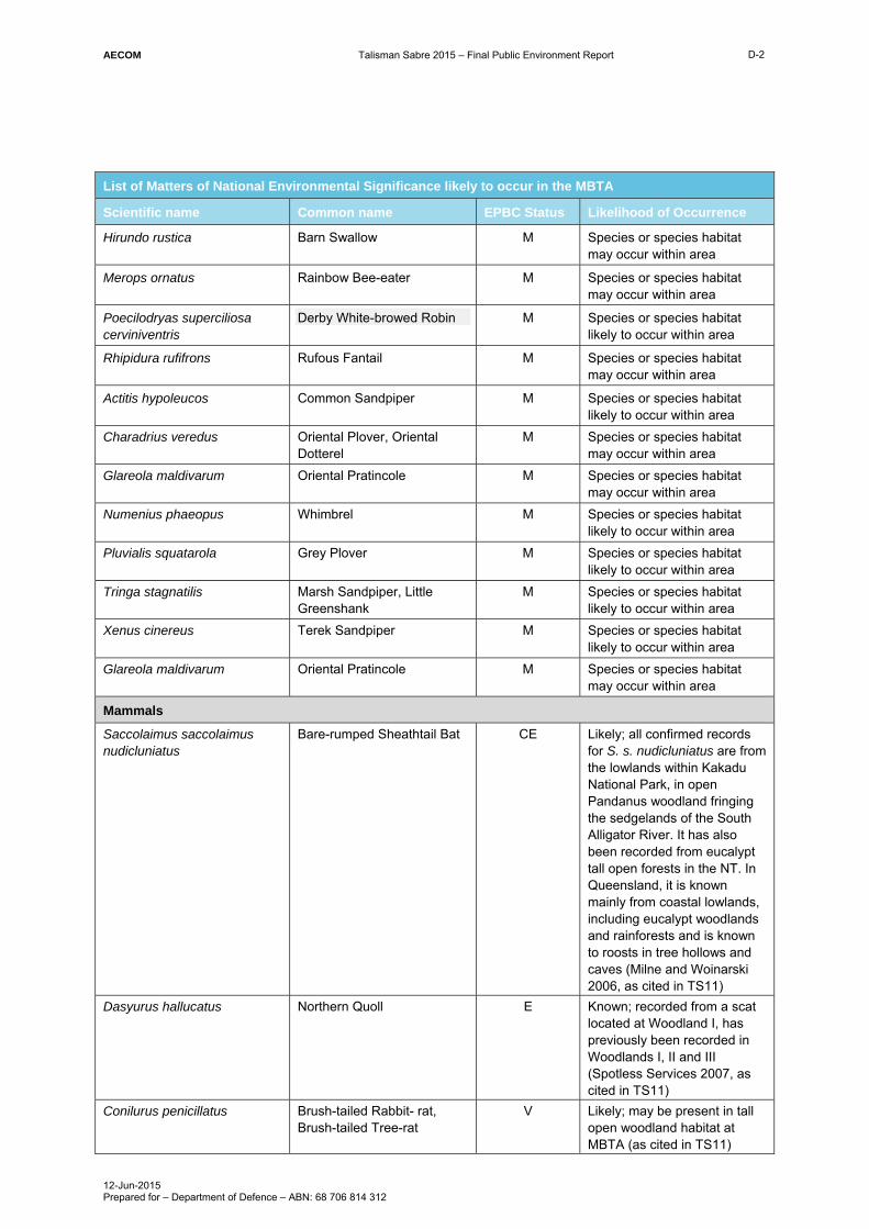
AECOM Talisman Sabre 2015 – Final Public Environment Report
12-Jun-2015 Prepared for – Department of Defence – ABN: 68 706 814 312
D-2
List of Matters of National Environmental Significance likely to occur in the MBTA
Scientific name Common name EPBC Status Likelihood of Occurrence
Hirundo rustica Barn Swallow M Species or species habitat may occur within area
Merops ornatus Rainbow Bee-eater M Species or species habitat may occur within area
Poecilodryas superciliosa cerviniventris
Derby White-browed Robin M Species or species habitat likely to occur within area
Rhipidura rufifrons Rufous Fantail M Species or species habitat may occur within area
Actitis hypoleucos Common Sandpiper M Species or species habitat likely to occur within area
Charadrius veredus Oriental Plover, Oriental Dotterel
M Species or species habitat may occur within area
Glareola maldivarum Oriental Pratincole M Species or species habitat may occur within area
Numenius phaeopus Whimbrel M Species or species habitat likely to occur within area
Pluvialis squatarola Grey Plover M Species or species habitat likely to occur within area
Tringa stagnatilis Marsh Sandpiper, Little Greenshank
M Species or species habitat likely to occur within area
Xenus cinereus Terek Sandpiper M Species or species habitat likely to occur within area
Glareola maldivarum Oriental Pratincole M Species or species habitat may occur within area
Mammals
Saccolaimus saccolaimus nudicluniatus
Bare-rumped Sheathtail Bat CE Likely; all confirmed records for S. s. nudicluniatus are from the lowlands within Kakadu National Park, in open Pandanus woodland fringing the sedgelands of the South Alligator River. It has also been recorded from eucalypt tall open forests in the NT. In Queensland, it is known mainly from coastal lowlands, including eucalypt woodlands and rainforests and is known to roosts in tree hollows and caves (Milne and Woinarski 2006, as cited in TS11)
Dasyurus hallucatus Northern Quoll E Known; recorded from a scat located at Woodland I, has previously been recorded in Woodlands I, II and III (Spotless Services 2007, as cited in TS11)
Conilurus penicillatus Brush-tailed Rabbit- rat, Brush-tailed Tree-rat
V Likely; may be present in tall open woodland habitat at MBTA (as cited in TS11)

AECOM Talisman Sabre 2015 – Final Public Environment Report
12-Jun-2015 Prepared for – Department of Defence – ABN: 68 706 814 312
D-3
List of Matters of National Environmental Significance likely to occur in the MBTA
Scientific name Common name EPBC Status Likelihood of Occurrence
Mesembriomys macrurus Golden-backed Tree- rat V May; last known NT record 1969 at Deaf Adder Gorge, all NT records from riverine habitat - known from a broad range of habitat types in the Kimberley (Woinarski and Palmer 2006, as cited in TS11)
Phascogale pirata Northern Brush-tailed Phascogale
V May; species has not been recorded but training area is within species range
Zyzomys maini Arnhem Rock-rat, Arnhem Land Rock-rat
V May; species has not been recorded but training area is within species range
Reptiles
Lucasium occultum Yellow-snouted Gecko E Known; woodland (type 3) habitat near JimJim Road 2004 (one record); potentially present northeastern MBTA, particularly Arnhem and Barramundi sectors; a single individual was caught in a pitfall trap during the 2004 survey in Woodland III habitat beside Jim Jim Road (HLA 2007, as cited in TS11)
Crocodylus porosus Salt-water Crocodile, Estuarine Crocodile
M Species or species habitat likely to occur within area
Sharks
Pristis microdon Freshwater Sawfish V May; within range (Larson, Stirrat and Woinarski 2006, as cited in TS11)
Pristis pristis Largetooth Sawfish, Freshwater Sawfish, River Sawfish, Leichardt’s Sawfish, Northern Sawfish
V May; species has not been recorded but training area is within species range
Plants
Arenga australasica Australian Arenga Palm V May; within range. However, NT populations considered secure and not threatened (Holmes et al. 2005).
Key CE – Critically Endangered E – Endangered V – Vulnerable M – Marine and/or Migratory

AECOM Talisman Sabre 2015 – Final Public Environment Report
12-Jun-2015 Prepared for – Department of Defence – ABN: 68 706 814 312
Appendix E
List of Threatened Communities, Species and Migratory Species for Delamere Range Facility

AECOM Talisman Sabre 2015 – Final Public Environment Report
12-Jun-2015 Prepared for – Department of Defence – ABN: 68 706 814 312
E-1
Appendix E List of Threatened Communities, Species and Migratory Species for Delamere Range Facility
List of Matters of National Environmental Significance likely to occur in the DRF
Scientific name Common name EPBC Status Likelihood of Occurrence
Birds
Erythrotriorchis radiatus Red Goshawk V May; lack of available information on DRF vegetation, fauna and habitat (as cited in TS11)
Erythrura gouldiae Gouldian Finch E, M Known; E. gouldiae documented in the Delamere region by Low, Dobbie and Roeger (1988) (Low Ecological Services 2000, as cited in TS11)
Falcunculus frontatus whitei Crested Shrike-tit (northern), Northern Shrike-tit
V, M Likely; species may be present in eucalypt woodland and forest habitat at DRF (Woinarski and Ward 2006, as cited in TS11)
Malurus coronatus coronatus Purple-crowned Fairy-wren
(western)
V May; lack of available information on DRF vegetation, fauna and habitat (as cited in TS11)
Tyto novaehollandiae kimberli Masked Owl (northern) V Likely; habitat occurs which is likely to support the species.
Rostratula australis Australian Painted Snipe V May; it is considered possible that R. australis could occur in northern NT (Taylor, Chatto and Woinarski 2006, as cited in TS11)
Rostratula benghalensis (sensu lato)
Painted Snipe V, M May; Species or species habitat may occur within area
Apus pacificus Fork-tailed Swift M Species or species habitat may occur within area
Ardea alba Great Egret, White Egret M Species or species habitat may occur within area
Ardea ibis Cattle Egret M Species or species habitat may occur within area
Haliaeetus leucogaster White-bellied Sea-Eagle M Species or species habitat likely to occur within area
Merops ornatus Rainbow Bee-eater M Species or species habitat may occur within area
Charadrius veredus Oriental Plover, Oriental Dotterel
M Species or species habitat may occur within area

AECOM Talisman Sabre 2015 – Final Public Environment Report
12-Jun-2015 Prepared for – Department of Defence – ABN: 68 706 814 312
E-2
List of Matters of National Environmental Significance likely to occur in the DRF
Scientific name Common name EPBC Status Likelihood of Occurrence
Glareola maldivarum Oriental Pratincole M Species or species habitat may occur within area
Mammals
Dasyurus hallucatus Northern Quoll E Likely; potentially present in rocky outcrops and near creek lines (Spotless Services 2007, as cited in TS11)
Phascogale pirata Northern Brush-tailed Phascogale
V May; species has not been recorded but training area is within the southernmost extent of species range
Saccolaimus saccolaimus nudicluniatus
Bare-rumped Sheathtail Bat CE May; species has not been recorded but training area is within species range
Macrotis lagotis Greater Bilby V May; species has not been recorded but training area is within species range
Reptiles
Elseya lavarackorum Gulf Snapping Turtle E May; species has not been recorded but training area is within species range
Sharks
Pristis microdon Freshwater Sawfish V Improbable; within range of species (Larson, Stirrat and Woinarski 2006, as cited in TS11); DRF topography is escarpment country with small ephemeral water bodies; probability of this species occurring at DRF likely to be low during the wet season, and impossible in the dry season (as cited in TS11)
Pristis pristis Large Sawfish, Freshwater Sawfish, River Sawfish, Leichhardt’s Sawfish, Northern Sawfish
V May; species has not been recorded but training area is within species range
Key CE – Critically Endangered E – Endangered V – Vulnerable M – Marine and/or Migratory

AECOM Talisman Sabre 2015 – Final Public Environment Report
12-Jun-2015 Prepared for – Department of Defence – ABN: 68 706 814 312
Appendix F
List of Threatened Communities, Species and Migratory Species for the Southern Activity Area, NT (Stingray Head, Fog Bay and Finniss River Station)

AECOM Talisman Sabre 2015 – Final Public Environment Report
12-Jun-2015 Prepared for – Department of Defence – ABN: 68 706 814 312
F-1
Appendix F List of Threatened Communities, Species and Migratory Species for the Southern Activity Area, NT (Stingray Head, Fog Bay and Finniss River Station)
List of Matters of National Environmental Significance likely to occur for the Southern Activity Area, NT (Stingray Head, Fog Bay and Finniss River Station)
Scientific name Common name EPBC Status Likelihood of Occurrence
Birds
Erythrura gouldiae Gouldian Finch E Improbable; no records or suitable habitat within Fog Bay.
Erythrotriorchis radiatus Red Goshawk V May; species recorded in close proximity to Southern Operations Area. Suitable habitat available.
Geophaps smithii smithii Partridge Pigeon (eastern) V May; observed within 10 km of the operation area and suitable habitat exists.
Rostratula australis Australian Painted Snipe E Improbable; no records within 10 km radius of operation area although some suitable habitat exists.
Rostratula benghalensis (sensu lato)
Painted Snipe V, M Improbable; no records or suitable habitat within Fog Bay
Tyto novaehollandiae kimberli Masked Owl (northern) V May; records for the species within a 10 km radius of the Stringray Head beach landing site and suitable habitat exists.
Apus pacificus Fork-tailed Swift M Low; no records or suitable habitat within Fog Bay. Species likely to be observed as a flyover on arrival between October and November.
Ardea alba Great Egret, White Egret M Likely; records for the species within Fog Bay and suitable habitat exists.
Ardea ibis Cattle Egret M May; records for the species within Fog Bay.
Sterna albifrons Little Tern M Known; database records for the species and suitable habitat in close proximity to the operation area. Species recorded in large numbers by Dr Bamford during December 2014 site visit (~1000 birds).
Haliaeetus leucogaster White-bellied Sea-Eagle M Likely; records for the species within a 10 km radius of the operations area.

AECOM Talisman Sabre 2015 – Final Public Environment Report
12-Jun-2015 Prepared for – Department of Defence – ABN: 68 706 814 312
F-2
List of Matters of National Environmental Significance likely to occur for the Southern Activity Area, NT (Stingray Head, Fog Bay and Finniss River Station)
Scientific name Common name EPBC Status Likelihood of Occurrence
Hirundo rustica Barn Swallow M May; expected to be a regular migrant albeit at low numbers.
Merops ornatus Rainbow Bee-eater M Known; previously recorded within the Southern Operations Area. Also recorded by Dr Bamford during December 2014 site visit.
Rhipidura rufifrons Rufous Fantail M Improbable; no records or suitable habitat within Fog Bay.
Actitis hypoleucos Common Sandpiper M High: database records for the species and suitable habitat in close proximity to the operation area. Recorded by Dr Bamford during December 2014 site visit.
Arenaria interpres Ruddy Turnstone M High; database records for the species and suitable habitat in close proximity to the operation area. Recorded by Dr Bamford during December 2014 site visit.
Sula leucogaster Brown Booby M Low; records for the species within Fog Bay, although species unlikely to be found close to shore.
Sterna sumatrana Black-naped Tern M May; records of the species exist in Fog Bay.
Sterna caspia Caspian Tern M Likely; records for the species within a 10 km radius of the operation area, and suitable habitat exists. Recorded by Dr Bamford during December 2014 site visit within area.
Tringa nebularia Common Greenshank M High; database records for the species within a 10 km radius of the operation area and suitable habitat exists. Recorded by Dr Bamford during December 2014 site visit.
Calidris acuminata Sharp-tailed Sandpiper M Known; database records for the species within a 10 km radius of the operation area and suitable habitat exists. Also recorded by Mike Bamford during December 2014 site visit.

AECOM Talisman Sabre 2015 – Final Public Environment Report
12-Jun-2015 Prepared for – Department of Defence – ABN: 68 706 814 312
F-3
List of Matters of National Environmental Significance likely to occur for the Southern Activity Area, NT (Stingray Head, Fog Bay and Finniss River Station)
Scientific name Common name EPBC Status Likelihood of Occurrence
Calidris alba Sanderling M Likely; records for the species within a 10 km radius of the operation area and suitable habitat exists.
Calidris canutus Red Knot, Knot M Likely; records for the species and suitable habitat in close proximity to the operation area.
Thalasseus bengalensis Lesser Crested Tern M High; recorded by Dr Bamford during December 2014 site visit
Fregata minor
Great Frigatebird M May; species recorded within 10 km of operation area and suitable feeding habitat exists (although unlikely to be breeding habitat).
Fregata ariel
Lesser Frigatebird M May; records for the species within a 10 km radius of the operation area.
Calidris ferruginea Curlew Sandpiper M Likely; records for the species within Fog Bay and suitable habitat exists.
Plegadis flacinellus Glossy Ibis May; records for the species within Fog Bay.
Calidris ruficollis Red-necked Stint M Known; database records for the species and suitable habitat in close proximity to the operation area. Recorded by Dr Bamford during December 2014 site visit ~150 birds.
Calidris tenuirostris Great Knot M Likely; Fog Bay and adjacent islands are an internationally important site for the species, with a maximum count of 10,000 birds recorded at this location (Bamford et al. 2008).
Charadrius leschenaultii Greater Sand Plover, Large Sand Plover
M Known; Fog Bay and adjacent islands are an internationally important site for the species, with a maximum count of 1,800 birds recorded at this location (Bamford et al. 2008). Recorded by Dr Bamford during December 2014 site visit.
Charadrius mongolus Lesser Sand Plover, Mongolian Plover
M Known; recorded by Dr Bamford during December 2014 site visit.

AECOM Talisman Sabre 2015 – Final Public Environment Report
12-Jun-2015 Prepared for – Department of Defence – ABN: 68 706 814 312
F-4
List of Matters of National Environmental Significance likely to occur for the Southern Activity Area, NT (Stingray Head, Fog Bay and Finniss River Station)
Scientific name Common name EPBC Status Likelihood of Occurrence
Charadrius veredus Oriental Plover, Oriental Dotterel
M May; records for the species within a 10 km radius of the operation area.
Chlidonias leucopterus White-winged Tern M May; species recorded in Fog Bay.
Glareola maldivarum Oriental Pratincole M May; suitable habitat for the species.
Heteroscelus brevipes Grey-tailed Tattler M High; Fog Bay and adjacent islands are an internationally important site for the species, with a maximum count of 560 birds at this location (Bamford et al. 2008). Recorded by Dr Bamford during December 2014 site visit.
Limicola falcinellus Broad-billed Sandpiper M May; records for the species within Fog Bay (Chatto, 2003)
Limosa lapponica Bar-tailed Godwit M Known; species was recorded during field visit by Mike Bamford.
Sterna hirundo Common Tern M May; records for the species within Fog Bay.
Limosa limosa Black-tailed Godwit M Likely; Fog Bay and adjacent islands are considered an internationally important site for the species, with maximum counts of up to 1700 birds at this location (Bamford et al. 2008).
Numenius madagascariensis Eastern Curlew M Known; database records for the species and suitable habitat in close proximity to the operation area. Also recorded by Dr Mike Bamford during December 2014 site visit.
Egretta sacra
Eastern Reef Egret M Likely; records for the species and suitable habitat in close proximity to the operation area.
Numenius minutus Little Curlew, Little Whimbrel M May; record for the species within 10 km of Southern Operations Area, although suitable habitat does not exist.
Pandion cristatus Osprey M May; records of the species within Fog Bay (Chatto, 2006).

AECOM Talisman Sabre 2015 – Final Public Environment Report
12-Jun-2015 Prepared for – Department of Defence – ABN: 68 706 814 312
F-5
List of Matters of National Environmental Significance likely to occur for the Southern Activity Area, NT (Stingray Head, Fog Bay and Finniss River Station)
Scientific name Common name EPBC Status Likelihood of Occurrence
Numenius phaeopus Whimbrel M Known; Previously recorded within the operation area. Recorded by Dr Bamford during December 2014 site visit.
Pluvialis fulva Pacific Golden Plover M May; species recorded in Fog Bay.
Pluvialis squatarola Grey Plover M Known; records for the species and suitable habitat in close proximity to the operation area. Recorded by Dr Bamford during December 2014 site visit.
Tringa stagnatilis Marsh Sandpiper, Little Greenshank
M May; records for the species within Fog Bay.
Xenus cinereus Terek Sandpiper M High; Fog Bay and adjacent islands are an internationally important site for the species, with a maximum count of 800 birds at this location (Bamford et al. 2008). Recorded by Dr Bamford during December 2014 site visit.
Limnodromus semipalmatus Asian Dowitcher M May; there are records of the species within Fog Bay (Chatto, 2003).
Mammals
Saccolaimus saccolaimus nudicluniatus
Bare-rumped Sheathtail Bat CE Improbable; no records or suitable habitat within Fog Bay.
Conilurus penicillatus Brush-tailed Rabbit-rat, Brush-tailed Tree-rat, Pakooma
V Improbable; no records although suitable habitat exists in inland areas.
Dasyurus hallucatus Northern Quoll E Low; no records or suitable habitat within Fog Bay.
Phascogale pirata Northern Brush-tailed Phascogale
V May; no records although suitable habitat exists.
Xeromys myoides Water Mouse, False Water Rat, Yirrkoo
V May; no records although suitable habitat exists.
Dugong dugon Dugong M May; records for the species within a 10 km radius of the operations area.
Whales and other cetaceans
Balaenoptera musculus Blue Whale E, M Improbable; no records or suitable habitat within Fog Bay

AECOM Talisman Sabre 2015 – Final Public Environment Report
12-Jun-2015 Prepared for – Department of Defence – ABN: 68 706 814 312
F-6
List of Matters of National Environmental Significance likely to occur for the Southern Activity Area, NT (Stingray Head, Fog Bay and Finniss River Station)
Scientific name Common name EPBC Status Likelihood of Occurrence
Megaptera novaeangliae Humpback Whale V, M Moderate; no records for the species although survey effort likely to be minimal. Suitable habitat exists within Fog Bay.
Balaenoptera edeni Bryde’s Whale M May; no records although suitable habitat exists in inland areas.
Orcaella brevirostris Irrawaddy Dolphin M May; records for the species within a 10 km radius of the operations area.
Orcinus orca Killer Whale, Orca M May; records for the species within a 10 km radius of the operations area.
Sousa chinensis Indo-Pacific Humpback Dolphin
M May; records for the species within a 10 km radius of the operations area.
Tursiops aduncus (Arafura/Timor Sea populations)
Spotted Bottlenose Dolphin (Arafura/Timor Sea populations)
M May; records for the species within a 10 km radius of the operations area.
Orcaella heinsohni
Australian Snubfin Dolphin May; records for the species within a 10 km radius of the operations area.
Reptiles
Caretta caretta Loggerhead Turtle E, M Likely; Fog Bay is a common feeding ground for Loggerhead Turtle, although the species is not known to nest in Northern Territory (Taylor et al. 2006).
Chelonia mydas Green Turtle V, M Likely; records for the species within a 10 km radius of the operations area.
Dermochelys coriacea Leatherback Turtle, Leathery Turtle, Luth
E, M Improbable; only nesting site known in Northern Territory is along the Cobourg Peninsula (Chatto and Baker, 2008).
Eretmochelys imbricate Hawksbill Turtle V, M May; records for the species within a 10 km radius of the operations area.
Lepidochelys olivacea Olive Ridley Turtle, Pacific Ridley Turtle
E, M Likely; records for the species within a 10 km radius of the operations area.
Natator depressus Flatback Turtle V, M Likely; records for the species within a 10 km radius of the operation area.
Acanthophis hawkei Plains Death Adder V Improbable; no records or suitable habitat within Fog Bay.

AECOM Talisman Sabre 2015 – Final Public Environment Report
12-Jun-2015 Prepared for – Department of Defence – ABN: 68 706 814 312
F-7
List of Matters of National Environmental Significance likely to occur for the Southern Activity Area, NT (Stingray Head, Fog Bay and Finniss River Station)
Scientific name Common name EPBC Status Likelihood of Occurrence
Crocodylus porosu Salt-water Crocodile, Estuarine Crocodile
M Likely; records for the species within a 10 km radius of the operations area and suitable habitat exists. Species is known to nest in Finniss River.
Sharks
Glyphis garricki Northern River Shark, New Guinea River Shark
E Improbable; the species is not known to occur outside of river systems (i.e. coastal and marine environs), and therefore is unlikely to be found in the area where the training exercise is to be conducted or immediate surrounds.
Carcharodon carcharias Great White Shark V, M Improbable; no records or suitable habitat within Fog Bay
Pristis clavata Dwarf Sawfish, Queensland Sawfish
V Improbable; species has not been recorded within the Finniss River System or any adjoining river systems.
Pristis pristis Largetooth Sawfish, Freshwater Sawfish, River Sawfish, Leichhardt’s Sawfish, Northern Sawfish
V May; There is potential for the species to occur in the Finniss River given that it has been recorded in the adjoining (but not connected) Adelaide River. May also occur in marine areas of Fog Bay.
Pristis zijsron Green Sawfish, Dindagubba, Narrowsnout Sawfish
V May; species found in Fog Bay (Guinea, 2015).
Rhincodon typus Whale Shark V, M May; there is little knowledge on the distribution of the species within waters off Northern Territory (Woinarski and Larson, 2006); however, it is assumed the species has potential to be present within the waters where the training exercise will take place.
Fish
Manta birostris Giant Manta Ray, Chevron Manta Ray, Pacific Manta Ray
M May; records for the species within a 10 km radius of the operations area.
Key CE – Critically Endangered E – Endangered V – Vulnerable M – Marine and/or Migratory

AECOM Talisman Sabre 2015 – Final Public Environment Report
12-Jun-2015 Prepared for – Department of Defence – ABN: 68 706 814 312
Appendix G
List of Threatened Communities, Species and Migratory Species for Northern Activity Area, NT (Native Point, Fog Bay and Dundee Beach Landing Strip)
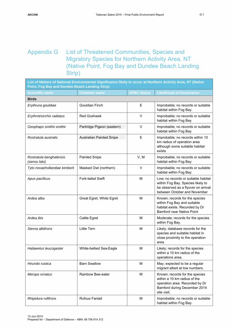
AECOM Talisman Sabre 2015 – Final Public Environment Report
12-Jun-2015 Prepared for – Department of Defence – ABN: 68 706 814 312
G-1
Appendix G List of Threatened Communities, Species and Migratory Species for Northern Activity Area, NT (Native Point, Fog Bay and Dundee Beach Landing Strip)
List of Matters of National Environmental Significance likely to occur at Northern Activity Area, NT (Native Point, Fog Bay and Dundee Beach Landing Strip)
Scientific name Common name EPBC Status Likelihood of Occurrence
Birds
Erythrura gouldiae Gouldian Finch E Improbable; no records or suitable habitat within Fog Bay.
Erythrotriorchis radiatus Red Goshawk V Improbable; no records or suitable habitat within Fog Bay
Geophaps smithii smithii Partridge Pigeon (eastern) V Improbable; no records or suitable habitat within Fog Bay
Rostratula australis Australian Painted Snipe E Improbable; no records within 10 km radius of operation area although some suitable habitat exists
Rostratula benghalensis (sensu lato)
Painted Snipe V, M Improbable; no records or suitable habitat within Fog Bay
Tyto novaehollandiae kimberli Masked Owl (northern) V Improbable; no records or suitable habitat within Fog Bay
Apus pacificus Fork-tailed Swift M Low; no records or suitable habitat within Fog Bay. Species likely to be observed as a flyover on arrival between October and November
Ardea alba Great Egret, White Egret M Known; records for the species within Fog Bay and suitable habitat exists. Recorded by Dr Bamford near Native Point
Ardea ibis Cattle Egret M Moderate; records for the species within Fog Bay.
Sterna albifrons Little Tern M Likely; database records for the species and suitable habitat in close proximity to the operation area.
Haliaeetus leucogaster White-bellied Sea-Eagle M Likely; records for the species within a 10 km radius of the operations area.
Hirundo rustica Barn Swallow M May; expected to be a regular migrant albeit at low numbers.
Merops ornatus Rainbow Bee-eater M Known; records for the species within a 10 km radius of the operation area. Recorded by Dr Bamford during December 2014 site visit.
Rhipidura rufifrons Rufous Fantail M Improbable; no records or suitable habitat within Fog Bay.

AECOM Talisman Sabre 2015 – Final Public Environment Report
12-Jun-2015 Prepared for – Department of Defence – ABN: 68 706 814 312
G-2
List of Matters of National Environmental Significance likely to occur at Northern Activity Area, NT (Native Point, Fog Bay and Dundee Beach Landing Strip)
Scientific name Common name EPBC Status Likelihood of Occurrence
Actitis hypoleucos Common Sandpiper M High; database records for the species and suitable habitat in close proximity to the operation area. Recorded by Dr Bamford during December 2014 site visit.
Arenaria interpres Ruddy Turnstone M High; database records for the species and suitable habitat in close proximity to the operation area. Recorded by Dr Bamford during December 2014 site visit.
Sula leucogaster Brown Booby M Low; records for the species within Fog Bay, although species unlikely to be found close to shore.
Sterna sumatrana Black-naped Tern M May; records of the species exist in Fog Bay.
Sterna caspia Caspian Tern M Likely; records for the species within a 10 km radius of the operation area, and suitable habitat exists. Recorded by Dr Bamford during December 2014 site visit within area.
Tringa nebularia Common Greenshank M High; database records for the species within a 10 km radius of the operation area and suitable habitat exists. Recorded by Dr Bamford during December 2014 site visit.
Calidris acuminata Sharp-tailed Sandpiper M Likely; database records for the species within a 10 km radius of the operation area and suitable habitat exists.
Calidris alba Sanderling M Likely; records for the species within a 10 km radius of the operation area and suitable habitat exists.
Calidris canutus Red Knot, Knot M Likely; records for the species and suitable habitat in close proximity to the operation area.
Thalasseus bengalensis Lesser Crested Tern M High; recorded by Dr Bamford during December 2014 site visit
Fregata minor
Great Frigatebird M May; species recorded within 10 km of operation area and suitable feeding habitat exists (although unlikely to be breeding habitat).
Fregata ariel
Lesser Frigatebird M May; records for the species within a 10 km radius of the operation area.

AECOM Talisman Sabre 2015 – Final Public Environment Report
12-Jun-2015 Prepared for – Department of Defence – ABN: 68 706 814 312
G-3
List of Matters of National Environmental Significance likely to occur at Northern Activity Area, NT (Native Point, Fog Bay and Dundee Beach Landing Strip)
Scientific name Common name EPBC Status Likelihood of Occurrence
Calidris ferruginea Curlew Sandpiper
M Likely; records for the species within Fog Bay and suitable habitat exists.
Plegadis flacinellus
Glossy Ibis May; records for the species within Fog Bay.
Calidris ruficollis Red-necked Stint M Known; database records for the species and suitable habitat in close proximity to the operation area. Recorded by Dr Bamford during December 2014 site visit ~150 birds.
Calidris tenuirostris Great Knot M Known; Fog Bay and adjacent islands are an internationally important site for the species, with a maximum count of 10,000 birds recorded at this location (Bamford et al. 2008). Recorded by Dr Bamford during December 2014 site visit.
Charadrius leschenaultii Greater Sand Plover, Large Sand Plover
M Know; Fog Bay and adjacent islands are an internationally important site for the species, with a maximum count of 1,800 birds recorded at this location (Bamford et al. 2008). Recorded by Dr Bamford during December 2014 site visit.
Charadrius mongolus Lesser Sand Plover, Mongolian Plover
M Likely; records for the species within a 10 km radius of the operation area and suitable habitat exists.
Charadrius veredus Oriental Plover, Oriental Dotterel
M May; records for the species within a 10 km radius of the operation area.
Chlidonias leucopterus
White-winged Tern M Likely; records for the species and suitable habitat in close proximity to the operations area.
Glareola maldivarum Oriental Pratincole M May; suitable habitat for the species.
Heteroscelus brevipes Grey-tailed Tattler M High; Fog Bay and adjacent islands are an internationally important site for the species, with a maximum count of 560 birds at this location (Bamford et al. 2008). Recorded by Dr Bamford during December 2014 site visit.
Limicola falcinellus Broad-billed Sandpiper M May; records for the species within Fog Bay (Chatto, 2003)

AECOM Talisman Sabre 2015 – Final Public Environment Report
12-Jun-2015 Prepared for – Department of Defence – ABN: 68 706 814 312
G-4
List of Matters of National Environmental Significance likely to occur at Northern Activity Area, NT (Native Point, Fog Bay and Dundee Beach Landing Strip)
Scientific name Common name EPBC Status Likelihood of Occurrence
Limosa lapponica Bar-tailed Godwit M Likely; records for the species within a 10 km radius of the operation area and suitable habitat exists. Species was also recorded during field visit by Mike Bamford at Southern Operations Area.
Sterna hirundo Common Tern M May; records for the species within Fog Bay.
Limosa limosa Black-tailed Godwit M Likely; Fog Bay and adjacent islands are considered an internationally important site for the species, with maximum counts of up to 1700 birds at this location (Bamford et al. 2008).
Numenius madagascariensis Eastern Curlew M Known; database records for the species and suitable habitat in close proximity to the operation area. Also recorded by Dr Mike Bamford during December 2014 site visit.
Egretta sacra Eastern Reef Egret M Likely; records for the species and suitable habitat in close proximity to the operation area.
Numenius minutus Little Curlew, Little Whimbrel M Improbable; record for the species within 10 km of Southern Operations Area although suitable habitat does not exist.
Pandion cristatus Osprey M May; records of the species within Fog Bay (Chatto, 2006).
Numenius phaeopus Whimbrel M Known; Previously recorded within the operation area. Recorded by Dr Bamford during December 2014 site visit.
Pluvialis fulva Pacific Golden Plover M Likely; records for the species and suitable habitat in close proximity to the operation area (Chatto, 2003).
Pluvialis squatarola Grey Plover M Known; records for the species and suitable habitat in close proximity to the operation area. Recorded by Dr Bamford during December 2014 site visit.
Tringa stagnatilis Marsh Sandpiper, Little Greenshank
M May; records for the species within Fog Bay.

AECOM Talisman Sabre 2015 – Final Public Environment Report
12-Jun-2015 Prepared for – Department of Defence – ABN: 68 706 814 312
G-5
List of Matters of National Environmental Significance likely to occur at Northern Activity Area, NT (Native Point, Fog Bay and Dundee Beach Landing Strip)
Scientific name Common name EPBC Status Likelihood of Occurrence
Xenus cinereus Terek Sandpiper M High; Fog Bay and adjacent islands are an internationally important site for the species, with a maximum count of 800 birds at this location (Bamford et al. 2008). Recorded by Dr Bamford during December 2014 site visit.
Limnodromus semipalmatus Asian Dowitcher M May; there are records of the species within Fog Bay (Chatto, 2003).
Mammals
Saccolaimus saccolaimus nudicluniatus
Bare-rumped Sheathtail Bat CE Improbable; no records or suitable habitat within Fog Bay.
Conilurus penicillatus Brush-tailed Rabbit-rat, Brush-tailed Tree-rat, Pakooma
V Improbable; no records although suitable habitat exists in inland areas.
Dasyurus hallucatus Northern Quoll E Low; no records or suitable habitat within Fog Bay.
Phascogale pirata Northern Brush-tailed Phascogale
V May; no records although suitable habitat exists.
Xeromys myoides Water Mouse, False Water Rat, Yirrkoo
V Improbable – no records or suitable habitat exists.
Dugong dugon Dugong M May; records for the species within a 10 km radius of the operations area.
Whales and other cetaceans
Balaenoptera musculus Blue Whale E, M Improbable; no records or suitable habitat within Fog Bay
Megaptera novaeangliae Humpback Whale V, M Moderate; no records for the species although survey effort likely to be minimal. Suitable habitat exists within Fog Bay.
Balaenoptera edeni Bryde’s Whale M May; no records although suitable habitat exists in inland areas.
Orcaella brevirostris Irrawaddy Dolphin M May; records for the species within a 10 km radius of the operations area.
Orcinus orca Killer Whale, Orca M May; records for the species within a 10 km radius of the operations area.
Sousa chinensis Indo-Pacific Humpback Dolphin
M Likely; records for the species and suitable habitat in close proximity to the operations areas.
Tursiops aduncus (Arafura/Timor Sea populations)
Spotted Bottlenose Dolphin (Arafura/Timor Sea populations)
M May; records for the species within a 10 km radius of the operations area.

AECOM Talisman Sabre 2015 – Final Public Environment Report
12-Jun-2015 Prepared for – Department of Defence – ABN: 68 706 814 312
G-6
List of Matters of National Environmental Significance likely to occur at Northern Activity Area, NT (Native Point, Fog Bay and Dundee Beach Landing Strip)
Scientific name Common name EPBC Status Likelihood of Occurrence
Orcaella heinsohni
Australian Snubfin Dolphin Likely; records for the species and suitable habitat in close proximity to the operations area.
Reptiles
Caretta caretta Loggerhead Turtle E, M Likely; Fog Bay is a common feeding ground for Loggerhead Turtle, although the species is not known to nest in Northern Territory (Taylor et al. 2006). Infonet has a single record for the species 1 km offshore from the Native Point beach landing site, and the species may also occur closer to shore.
Chelonia mydas Green Turtle V, M Likely; records for the species within a 10 km radius of the operations area.
Dermochelys coriacea Leatherback Turtle, Leathery Turtle, Luth
E, M Improbable; only nesting site known in Northern Territory is along the Cobourg Peninsula (Chatto and Baker, 2008).
Eretmochelys imbricate Hawksbill Turtle V, M May; records for the species within a 10 km radius of the operations area.
Lepidochelys olivacea Olive Ridley Turtle, Pacific Ridley Turtle
E, M Likely; records for the species within a 10 km radius of the operations area.
Natator depressus Flatback Turtle V, M Likely; records for the species within a 10 km radius of the operation area.
Acanthophis hawkei Plains Death Adder V Improbable; no records or suitable habitat within Fog Bay.
Crocodylus porosu Salt-water Crocodile, Estuarine Crocodile
M Likely; records for the species within a 10 km radius of the operations area and suitable habitat exists. According to Mike Bamford, species has been recorded along Dundee beach.
Sharks
Glyphis garricki Northern River Shark, New Guinea River Shark
E Improbable; the species is not known to occur outside of river systems (i.e. coastal and marine environs), and therefore is unlikely to be found in the area where the training exercise is to be conducted or immediate surrounds.
Carcharodon carcharias Great White Shark V, M Improbable – no records or suitable habitat within Fog Bay.

AECOM Talisman Sabre 2015 – Final Public Environment Report
12-Jun-2015 Prepared for – Department of Defence – ABN: 68 706 814 312
G-7
List of Matters of National Environmental Significance likely to occur at Northern Activity Area, NT (Native Point, Fog Bay and Dundee Beach Landing Strip)
Scientific name Common name EPBC Status Likelihood of Occurrence
Pristis clavata Dwarf Sawfish, Queensland Sawfish
V Improbable; species has not been recorded within the Finniss River System or any adjoining river systems.
Pristis pristis Largetooth Sawfish, Freshwater Sawfish, River Sawfish, Leichhardt’s Sawfish, Northern Sawfish
V May; There is potential for the species to occur in the Finniss River given that it has been recorded in the adjoining (but not connected) Adelaide River. May also occur in marine areas of Fog Bay.
Pristis zijsron Green Sawfish, Dindagubba, Narrowsnout Sawfish
V May; species found in Fog Bay (Guinea, 2015).
Rhincodon typus Whale Shark V, M May; there is little knowledge on the distribution of the species within waters off Northern Territory (Woinarski and Larson, 2006); however, it is assumed the species has potential to be present within the waters where the training exercise will take place.
Fish
Manta birostris Giant Manta Ray, Chevron Manta Ray, Pacific Manta Ray
M May; records for the species within a 10 km radius of the operations area.
Key CE – Critically Endangered E – Endangered V – Vulnerable M – Marine and/or Migratory

AECOM Talisman Sabre 2015 – Final Public Environment Report
12-Jun-2015 Prepared for – Department of Defence – ABN: 68 706 814 312
Appendix H
List of Threatened Communities, Species and Migratory Species for Lee Point, Northern Territory

AECOM Talisman Sabre 2015 – Final Public Environment Report
12-Jun-2015 Prepared for – Department of Defence – ABN: 68 706 814 312
H-1
Appendix H List of Threatened Communities, Species and Migratory Species for Lee Point, Northern Territory
List of Matters of National Environmental Significance likely to occur at Lee Point, Northern Territory
Scientific name Common name EPBC Status Likelihood of Occurrence
Birds
Erythrura gouldiae Gouldian Finch E May; suitable habitat for species available and previously recorded in search area
Erythrotriorchis radiatus Red Goshawk V May; suitable habitat for species available within area
Geophaps smithii smithii Partridge Pigeon (eastern) V May; suitable habitat for species available within area
Rostratula australis Australian Painted Snipe E Improbable; limited availability of suitable habitat within area.
Rostratula benghalensis (sensu lato)
Painted Snipe V, M Improbable; limited availability of suitable habitat within area
Tyto novaehollandiae kimberli Masked Owl (northern) V May; suitable habitat for species available within area
Apus pacificus Fork-tailed Swift M Species or species habitat likely to within area
Ardea alba Great Egret, White Egret M Species or species habitat known to occur within area
Ardea ibis Cattle Egret M Species or species habitat may occur within area
Sterna albifrons Little Tern M Species or species habitat may occur within area
Haliaeetus leucogaster White-bellied Sea-Eagle M Species or species habitat known to occur within area
Hirundo rustica Barn Swallow M Species or species habitat may occur within area
Merops ornatus Rainbow Bee-eater M Species or species habitat may occur within area
Rhipidura rufifrons Rufous Fantail M Species or species habitat known to occur within area
Actitis hypoleucos Common Sandpiper M Roosting known to occur within area
Arenaria interpres Ruddy Turnstone M Roosting known to occur within area
Calidris acuminata Sharp-tailed Sandpiper M Roosting known to occur within area
Calidris alba Sanderling M Roosting known to occur within area
Calidris canutus Red Knot, Knot M Roosting known to occur within area
Calidris ferruginea Curlew Sandpiper M Roosting known to occur within area

AECOM Talisman Sabre 2015 – Final Public Environment Report
12-Jun-2015 Prepared for – Department of Defence – ABN: 68 706 814 312
H-2
List of Matters of National Environmental Significance likely to occur at Lee Point, Northern Territory
Scientific name Common name EPBC Status Likelihood of Occurrence
Calidris ruficollis Red-necked Stint M Roosting known to occur within area
Calidris tenuirostris Great Knot M Roosting known to occur within area
Charadrius leschenaultii Greater Sand Plover, Large Sand Plover
M Roosting known to occur within area
Charadrius mongolus Lesser Sand Plover, Mongolian Plover
M Roosting known to occur within area
Charadrius veredus Oriental Plover, Oriental Dotterel
M Roosting known to occur within area
Glareola maldivarum Oriental Pratincole M Roosting known to occur within area
Heteroscelus brevipes Grey-tailed Tattler M Roosting known to occur within area
Limicola falcinellus Broad-billed Sandpiper M Roosting known to occur within area
Limosa lapponica Bar-tailed Godwit M Roosting known to occur within area
Limosa limosa Black-tailed Godwit M Roosting known to occur within area
Numenius madagascariensis Eastern Curlew M Roosting known to occur within area
Numenius minutus Little Curlew, Little Whimbrel M Roosting known to occur within area
Numenius phaeopus Whimbrel M Roosting known to occur within area
Pluvialis fulva Pacific Golden Plover M Roosting known to occur within area
Pluvialis squatarola Grey Plover M Roosting known to occur within area
Tringa glareola Wood Sandpiper M Roosting known to occur within area
Tringa stagnatilis Marsh Sandpiper, Little Greenshank
M Roosting known to occur within area
Xenus cinereus Terek Sandpiper M Roosting known to occur within area
Limnodromus semipalmatus Asian Dowitcher M Roosting known to occur within area
Mammals
Saccolaimus saccolaimus nudicluniatus
Bare-rumped Sheathtail Bat CE May; suitable habitat for species available within area.
Conilurus penicillatus Brush-tailed Rabbit-rat, Brush-tailed Tree-rat, Pakooma
V May; suitable habitat for species available
Dasyurus hallucatus Northern Quoll E May; suitable habitat for species available

AECOM Talisman Sabre 2015 – Final Public Environment Report
12-Jun-2015 Prepared for – Department of Defence – ABN: 68 706 814 312
H-3
List of Matters of National Environmental Significance likely to occur at Lee Point, Northern Territory
Scientific name Common name EPBC Status Likelihood of Occurrence
Phascogale pirata Northern Brush-tailed Phascogale
V Likely; suitable habitat for species available within area.
Xeromys myoides Water Mouse, False Water Rat, Yirrkoo
V Improbable; limited availability of suitable habitat within area
Dugong dugon Dugong M Species or species habitat known to occur within area
Whales and other cetaceans
Balaenoptera musculus Blue Whale E, M Improbable; limited availability of suitable habitat within area.
Megaptera novaeangliae Humpback Whale V, M Improbable; limited availability of suitable habitat within area.
Balaenoptera edeni Bryde’s Whale M Species or species habitat may occur within area
Orcaella brevirostris Irrawaddy Dolphin M Species or species habitat known to occur within area
Orcinus orca Killer Whale, Orca M Species or species habitat may occur within area
Sousa chinensis Indo-Pacific Humpback Dolphin
M Breeding known to occur within area
Tursiops aduncus (Arafura/Timor Sea populations)
Spotted Bottlenose Dolphin (Arafura/Timor Sea populations)
M Species or species habitat likely to within area
Reptiles
Caretta caretta Loggerhead Turtle E, M Likely; suitable habitat for species available and species recorded within area
Chelonia mydas Green Turtle V, M Likely; suitable habitat for species available and species recorded within area
Dermochelys coriacea Leatherback Turtle, Leathery Turtle, Luth
E, M Improbable; limited availability of suitable habitat within area.
Eretmochelys imbricate Hawksbill Turtle V, M Likely; suitable habitat for species available and species recorded within area
Lepidochelys olivacea Olive Ridley Turtle, Pacific Ridley Turtle
E, M Likely; suitable habitat for species available and species recorded within area
Natator depressus Flatback Turtle V, M Likely; suitable habitat for species available and species recorded within area
Acanthophis hawkei Plains Death Adder V Improbable; limited availability of suitable habitat within area.
Crocodylus porosu Salt-water Crocodile, Estuarine Crocodile
M Species or species habitat likely to within area
Sharks
Glyphis garricki Northern River Shark, New Guinea River Shark
E Improbable – limited availability of suitable habitat within area.

AECOM Talisman Sabre 2015 – Final Public Environment Report
12-Jun-2015 Prepared for – Department of Defence – ABN: 68 706 814 312
H-4
List of Matters of National Environmental Significance likely to occur at Lee Point, Northern Territory
Scientific name Common name EPBC Status Likelihood of Occurrence
Carcharodon carcharias Great White Shark V, M Improbable; limited availability of suitable habitat within area.
Pristis clavata Dwarf Sawfish, Queensland Sawfish
V May; suitable habitat for species available within area.
Pristis pristis Largetooth Sawfish, Freshwater Sawfish, River Sawfish, Leichhardt’s Sawfish, Northern Sawfish
V May; suitable habitat for species available within area.
Rhincodon typus Whale Shark V, M May; suitable habitat for species available within area.
Fish
Manta birostris Giant Manta Ray, Chevron Manta Ray, Pacific Manta Ray
M Species or species habitat may occur within area
Key CE – Critically Endangered E – Endangered V – Vulnerable M – Migratory

AECOM Talisman Sabre 2015 – Final Public Environment Report
12-Jun-2015 Prepared for – Department of Defence – ABN: 68 706 814 312
Appendix I
List of Threatened Communities, Species and Migratory Species for Shoalwater Bay Training Area

AECOM Talisman Sabre 2015 – Final Public Environment Report
12-Jun-2015 Prepared for – Department of Defence – ABN: 68 706 814 312
I-1
Appendix I List of Threatened Communities, Species and Migratory Species for Shoalwater Bay Training Area
List of Matters of National Environmental Significance likely to occur in the SWBTA
Scientific name Common name EPBC Status Likelihood of Occurrence
Threatened Ecological Communities
Littoral Rainforest and Coastal Vine Thickets of Eastern Australia
CE Known (O’Neill P. 2008. Forests, Woodlands and Freshwater Wetlands. In: SWBTA State of the Environment Report. Chapter 6. Department of Defence. Canberra, as cited in TS11)
Semi-evergreen vine thickets of the Brigalow Belt (North and South) and Nandewar Bioregions
E Known to occur at SWBTA.
Broad leaf tea tree (Melaleuca viridiflora) woodlands in high rainfall coastal north Queensland
E Known to occur at SWBTA.SWBTA.
Birds
Botaurus poiciloptilus Australasian Bittern E May; species has not been recorded but training area is within species range
Epthianura crocea macgregori Yellow Chat (Dawson) CE May; Suitable marine plain wetlands are present in SWBTA and Yellow Chat population present at Torilla Plains just west of SWBTA; however, never recorded in fauna surveys of SWBTA (as cited in TS11)
Macronectes giganteus Southern Giant-Petrel E, M May; Occasionally forages in waters off central Queensland coast during winter (as cited in TS11)
Neochmia ruficauda ruficauda Star Finch (eastern), Star Finch (southern)
E Improbable; Suitable grassy woodland habitat present close to water, but no records from recent fauna surveys in SWBTA or central Queensland (as cited in TS11)
Poephila cincta cincta Black-Throated Finch E Improbable; Suitable habitat is present, but not recorded in fauna surveys of SWBTA and no records from Rockhampton area since 1970s (as cited in TS11)
Thalassarche melanophris impavida
Campbell Albatross E May; species has not been recorded but training area is within species range
Geophaps scripta scripta Squatter Pigeon (southern) V Known; Recorded at site. Plain eucalypt woodland/open forest, hill eucalypt woodland/open forest, riparian forest/woodland, swamp forest/woodland, cleared land (HLA 2006, as cited in TS11)
Erythrotriorchis radiatus Red Goshawk V Likely; habitat occurs that is likely to support the species.

AECOM Talisman Sabre 2015 – Final Public Environment Report
12-Jun-2015 Prepared for – Department of Defence – ABN: 68 706 814 312
I-2
List of Matters of National Environmental Significance likely to occur in the SWBTA
Scientific name Common name EPBC Status Likelihood of Occurrence
Pterodroma neglecta neglecta Kermadec Petrel (western) V May; Occasionally forages in waters off central Queensland coast during winter (as cited in TS11)
Rostratula australis Australian Painted Snipe V May; Suitable shallow terrestrial freshwater wetlands are present (as cited in TS11)
Turnix melanogaster Black-breasted Button-quail V May; Suitable drier low closed forests are present, not recorded in fauna surveys in SWBTA but species is highly cryptic and difficult to detect (AECOM, 2010a, as cited in TS11)
Fregetta grallaria grallaria White-bellied Storm-Petrel (Tasman Sea), White-bellied Storm Petrel (Australasian)
V May; species has not been recorded but training area is within species range
Rostratula benghalensis (sensu lato).
Painted Snipe V, M May; species has not been recorded but training area is within species range
Calyptorhynchus lathami erebus
Glossy Black-Cockatoo (erebus); Casuarina Black-Cockatoo
Not listed – included for information
only
Known; Forests and woodlands with sheoaks are present at site (HLA 2006). While C.lathami is listed in South Australia, the SWBTA population is regionally endemic subspecies not listed under EPBC Act (PPK 1999)
Apus pacificus Fork-tailed Swift M Species or species habitat may occur within area
Puffinus carneipes Flesh-footed Shearwater, Fleshy-footed Shearwater
M Species or species habitat likely to occur within area
Ardea alba Great Egret, White Egret M Species or species habitat may occur within area
Ardea ibis Cattle Egret M Species or species habitat may occur within area
Sterna albifrons Little Tern M Species or species habitat may occur within area
Sterna caspia Caspian Tern M Breeding known to occur within area
Haliaeetus leucogaster White-bellied Sea-Eagle M Species or species habitat likely to occur within area
Hirundapus caudacutus White-throated Needletail M Species or species habitat may occur within area
Hirundo rustica Barn Swallow M Species or species habitat may occur within area
Merops ornatus Rainbow Bee-eater M Species or species habitat may occur within area
Monarcha melanopsis Black-faced Monarch M Breeding may occur within area
Monarcha trivirgatus Spectacled Monarch M Breeding likely to occur within area
Myiagra cyanoleuca Satin Flycatcher M Species or species habitat likely to occur within area

AECOM Talisman Sabre 2015 – Final Public Environment Report
12-Jun-2015 Prepared for – Department of Defence – ABN: 68 706 814 312
I-3
List of Matters of National Environmental Significance likely to occur in the SWBTA
Scientific name Common name EPBC Status Likelihood of Occurrence
Rhipidura rufifrons Rufous Fantail M Breeding may occur within area
Actitis hypoleucos Common Sandpiper M Roosting known to occur within area
Arenaria interpres Ruddy Turnstone M Roosting known to occur within area
Calidris acuminata Sharp-tailed Sandpiper M Roosting known to occur within area
Calidris canutus Red Knot, Knot M Foraging, feeding or related behaviour known to occur within area
Calidris ferruginea Curlew Sandpiper M Roosting known to occur within area
Calidris ruficollis Red-necked Stint M Roosting known to occur within area
Calidris tenuirostris Great Knot M Roosting known to occur within area
Charadrius leschenaultii Greater Sand Plover, Large
Sand Plover
M Roosting known to occur within area
Charadrius mongolus Lesser Sand Plover, Mongolian Plover
M Roosting known to occur within area
Gallinago hardwickii Latham's Snipe, Japanese
Snipe
M Roosting may occur within area
Heteroscelus brevipes Grey-tailed Tattler M Roosting known to occur within area
Limosa lapponica Bar-tailed Godwit M Roosting known to occur within area
Numenius madagascariensis Eastern Curlew M Known; in beaches and sea, Estuarine mudflats (as cited in TS11)
Numenius minutus Little Curlew, Little Whimbrel M Roosting likely to occur within area
Numenius phaeopus Whimbrel M Roosting known to occur within area
Pluvialis fulva Pacific Golden Plover M Roosting known to occur within area
Pluvialis squatarola Grey Plover M Roosting known to occur within area
Tringa stagnatilis Marsh Sandpiper, Little
Greenshank
M Foraging, feeding or related behaviour known to occur within area
Xenus cinereus Terek Sandpiper M Roosting known to occur within area
Mammals
Chalinolobus dwyeri Large-eared Pied Bat, Large
Pied Bat
V Known; Recorded at site. Mangroves, coastal vine forest, riparian forest/woodland, freshwater wetlands are present at site (HLA 2006, as cited in TS11)
Dasyurus hallucatus Northern Quoll E May; suitable rocky country in open eucalypt forest is present but species not recorded in fauna surveys at SWBTA (AECOM, 2010a, as cited in TS11)
Pteropus poliocephalus Grey-headed Flying-fox V Improbable; Current northern limit is Maryborough (Churchill, 2008, as cited in TS11)

AECOM Talisman Sabre 2015 – Final Public Environment Report
12-Jun-2015 Prepared for – Department of Defence – ABN: 68 706 814 312
I-4
List of Matters of National Environmental Significance likely to occur in the SWBTA
Scientific name Common name EPBC Status Likelihood of Occurrence
Xeromys myoides Water Mouse, False Water
Rat
V May; Mangroves and sedgelands are present on site (HLA 2006, as cited in TS11)
Phascolarctos cinereus (combined populations of Qld, NSW and the ACT)
Koala (combined populations of Queensland, New South Wales and the Australian Capital Territory)
V May; species has not been recorded but training area is within species range
Nyctophilus corbeni South-eastern Long-eared Bat
V May; species has not been recorded but training area is within species range
Whales and other cetaceans
Balaenoptera musculus Blue Whale E, M Improbable; Waters off Queensland are unlikely to provide significant feeding habitat for this species (as cited in TS11)
Megaptera novaeangliae Humpback Whale V, M Breeding known to occur within area
Balaenoptera edeni Bryde's Whale M Species or species habitat may occur within area
Dugong dugon Dugong M Species or species habitat likely to occur within area
Orcinus orca Killer Whale, Orca M Species or species habitat may occur within area
Sousa chinensis Indo-Pacific Humpback
Dolphin
M Species or species habitat may occur within area
Orcaella brevirostris Irrawaddy Dolphin M Species or species habitat may occur within area
Sharks
Carcharias taurus (east coast population)
Grey Nurse Shark (east coast population)
CE Species or species habitat may occur within area
Pristis zijsron Green Sawfish, Dindagubba, Narrowsnout Sawfish
V May; juveniles found inshore in foreshores and embayments (QLD DPI, 2009, as cited in TS11)
Rhincodon typus Whale Shark V Species or species habitat may occur within area
Lamna nasus Porbeagle, Mackerel Shark M Species or species habitat may occur within area
Carcharodon carcharias Great White Shark V Species or species habitat may occur within area
Fish
Pseudomugil mellis Honey Blue-eye V May; species has not been recorded but training area is within species range
Manta birostris Giant Manta Ray, Chevron Manta Ray, Pacific Manta Ray, pelagic Manta Ray, Oceanic Manta Ray
M Species or species habitat likely to occur within area

AECOM Talisman Sabre 2015 – Final Public Environment Report
12-Jun-2015 Prepared for – Department of Defence – ABN: 68 706 814 312
I-5
List of Matters of National Environmental Significance likely to occur in the SWBTA
Scientific name Common name EPBC Status Likelihood of Occurrence
Reptiles
Caretta caretta Loggerhead Turtle E, M May; species has not been recorded but training area is within species range
Chelonia mydas Green Turtle V, M Known (Breeding); Species has been recorded at site (L. Sommers and GBRMPA, pers. comm., as cited in TS11)
Denisonia maculata Ornamental Snake V Likely; habitat occurs that is likely to support the species
Egernia rugosa Yakka Skink V Likely; habitat occurs that is likely to support the species
Delma torquate Collared Delma V May; species has not been recorded but training area is within species range
Eretmochelys imbricata Hawksbill Turtle V, M May; species has not been recorded but training area is within species range
Furina dunmalli Dunmall's Snake V Improbable; Suitable brigalow habitat not present in SWBTA (as cited in TS11)
Dermochelys coriacea Leatherback Turtle, Leathery Turtle, Luth
E, M Known (Breeding); Species has been recorded at site (M. Drewe and GBRMPA, pers. comm., as cited in TS11)
Lepidochelys olivacea Olive Ridley Turtle, Pacific Ridley Turtle
E, M May; species has not been recorded but training area is within species range
Natator depressus Flatback Turtle E Known; Recorded on site (PPK 1999).
Dermochelys coriacea Leatherback Turtle, Leathery Turtle, Luth
E, M Known (Breeding); Species has been recorded at site (M. Drewe and GBRMPA, pers. comm., as cited in TS11)
Rheodytes leukops Fitzroy River Turtle, Fitzroy Tortoise, Fitzroy Turtle, White-eyed River Driver
V May; species has not been recorded but training area is within species range
Crocodylus porosus Salt-water Crocodile, Estuarine Crocodile
M Species or species habitat likely to occur within area
Plants
Cycas megacarpa Cycad E May; Ridge forest, hill Eucalypt woodland and open forest are present at site (HLA 2006, as cited in TS11)

AECOM Talisman Sabre 2015 – Final Public Environment Report
12-Jun-2015 Prepared for – Department of Defence – ABN: 68 706 814 312
I-6
List of Matters of National Environmental Significance likely to occur in the SWBTA
Scientific name Common name EPBC Status Likelihood of Occurrence
Cycas ophiolitica Cycad E Known; Recorded in ridge forest, hill eucalypt woodland/open forest, hill rainforest and vine thicket in association with Regional Ecosystem 11.11.15 at site (HLA 2006, as cited in TS11)
Streblus pendulinus Siah’s Backbone, Sia’s Backbone, Isaac Wood
E Likely; not recorded but suitable habitat occurs within SWBTA
Phaius australis Lesser Swamp-orchid E Known; Recorded at site (description not provided), (PPK 1999). Rainforests, wet eucalypt forest, swamp and wetlands are present at site (HLA 2007)
Pulenaea setulose E May; SWBTA within species range
Comesperma oblongatum Byfield Matchstick V Known; Recorded in headland grassfield and shrubfield at site (REs 8.2.3b, 8.2.7e, 8.2.8) (HLA 2006, as cited in TS11)
Grevillea venusta Byfield Spider Flower V Known; Recorded in riparian forest and woodland at site (REs 8.1.1, 8.3.3b, 8.11.3b,8.12.3c, 8.12.10a) (HLA 2006, as cited in TS11)
Leucopogon cuspidatus Beard Heath V Known; Recorded in eucalypt woodland in Pyri Pyri Sector (Queensland Herbarium, 2010, as cited in TS11)
Sowerbaea subtilis V Known; Recorded in swamp forest and woodland and freshwater wetlands (Res 8.2.2, 8.2.3, 8.2.4b) (HLA 2006, as cited in TS11)
Taeniophyllum muelleri Minute Orchid, Ribbon-root Orchid
V Known; in riparian closed Forest (as cited in TS11)
Omphala celata V May; SWBTA within species range
Samadera bidwillii V May; SWBTA within species range
Capparis thozetiana V May; SWBTA within species range
Corymbia xanthope Glen Geddes Bloodwood V May; SWBTA within species range
Hakea trineura Three-veined Hakea V May; no records on-site, although some potentially suitable hill eucalypt woodland/open forest is present at site (HLA 2006)
Marsdenia brevifolia V May; not recorded at SWBTA but within species range
Neoroepera buxifolia V May; SWBTA within species range

AECOM Talisman Sabre 2015 – Final Public Environment Report
12-Jun-2015 Prepared for – Department of Defence – ABN: 68 706 814 312
I-7
List of Matters of National Environmental Significance likely to occur in the SWBTA
Scientific name Common name EPBC Status Likelihood of Occurrence
Parsonia larcomensis Mt Larcom Silk Pod V Known; SPRAT states that the species grows at ‘Shoalwater Bay military reserve and surrounding regions’
Pimelea leptospermoides V May; SWBTA within species range
Key CE – Critically Endangered E – Endangered V – Vulnerable M – Marine and/or Migratory

AECOM Talisman Sabre 2015 – Final Public Environment Report
12-Jun-2015 Prepared for – Department of Defence – ABN: 68 706 814 312
Appendix J
List of Threatened Communities, Species and Migratory Species for Townsville Field Training Area

AECOM Talisman Sabre 2015 – Final Public Environment Report
12-Jun-2015 Prepared for – Department of Defence – ABN: 68 706 814 312
J-1
Appendix J List of Threatened Communities, Species and Migratory Species for Townsville Field Training Area
List of Matters of National Environmental Significance likely to occur in the TFTA
Scientific name Common name EPBC Status Likelihood of Occurrence
Threatened Ecological Communities
Broad leaf tea-tree (Melaleuca viridiflora) woodlands in high rainfall coastal north Queensland
E Community likely to occur within area
Birds
Casuarius casuarius johnsonii Southern Cassowary (Australian), Southern Cassowary
E Improbable; Suitable rainforest habitat not present in TFTA (as cited in TS11)
Erythrotriorchis radiatus Red Goshawk V Known; Confirmed occurrence on site (EES 2004). Species is known to occur along or near watercourses, in swamp forests and woodlands (NPWS 2002, as cited in TS11)
Geophaps scripta scripta Squatter Pigeon (southern) V Known; Recorded in grassy woodland on site (EES 2004, as cited in TS11)
Neochmia ruficauda ruficauda Star Finch (eastern), Star Finch (southern)
E Improbable; Grasslands and grassy woodlands close to freshwater bodies are not present on site (EES 2004, as cited in TS11)
Poephila cincta cincta Black-throated Finch (southern)
E Likely; Suitable grassy, open woodlands and forests are present in site (as cited in TS11)
Rostratula australis Australian Painted Snipe V May; Suitable shallow terrestrial freshwater wetlands are present (as cited in TS11)
Tyto novaehollandiae kimerli Masked Owl (northern) V Known; Species has been recorded on site. Species is found in partial cleared areas and eucalypt woodlands (HLA 2007)
Apus pacificus Fork-tailed Swift M Species or species habitat may occur within area
Ardea alba Great Egret, White Egret M Species or species habitat may occur within area
Ardea ibis Cattle Egret M Species or species habitat may occur within area
Haliaeetus leucogaster White-bellied Sea-Eagle M Species or species habitat likely to occur within area
Hirundapus caudacutus White-throated Needletail M Species or species habitat known to occur within area
Hirundo rustica Barn Swallow M Species or species habitat may occur within area
Merops ornatus Rainbow Bee-eater M Species or species habitat may occur within area

AECOM Talisman Sabre 2015 – Final Public Environment Report
12-Jun-2015 Prepared for – Department of Defence – ABN: 68 706 814 312
J-2
List of Matters of National Environmental Significance likely to occur in the TFTA
Scientific name Common name EPBC Status Likelihood of Occurrence
Monarcha melanopsis Black-faced Monarch M Species or species habitat known to occur within area
Monarcha trivirgatus Spectacled Monarch M Breeding likely to occur within area
Myiagra cyanoleuca Satin Flycatcher M Species or species habitat likely to occur within area
Rhipidura rufifrons Rufous Fantail M Breeding may occur within area
Gallinago hardwickii Latham's Snipe, Japanese Snipe
M Species or species habitat may occur within area
Grus antigone Sarus Crane M Species or species habitat likely to occur within area
Rostratula benghalensis (sensu lato)
Painted Snipe M Species or species habitat may occur within area
Mammals
Saccolaimus saccolaimus nudicluniatus
Bare-rumped Sheathtail Bat CE May; Suitable poplar gum woodland is present in site (as cited in TS11)
Bettongia tropica Northern Bettong E Likely; Grassy woodland is present on site in association with Regional Ecosystem 9.3.3 (SMEC 2004, as cited in TS11)
Dasyurus hallucatus Northern Quoll E Likely; Suitable rocky country in open eucalypt forest is present (Peter Buosi, pers. comm., as cited in TS11)
Dasyurus maculatus gracilis Spotted-tailed Quoll or Yarri (North Queensland subspecies)
E Improbable; Suitable upland rainforest habitat not present in TFTA (as cited in TS11)
Petaurus gracillis Mahogany Glider E May; species has not been recorded but training area is within species range
Hipposideros semoni Semon's Leaf-nosed Bat, Greater Wart-nosed Horseshoe-bat
E Improbable; Species prefers caves or abandoned mines (roosting habitats) and rainforests/vine thickets (foraging habitats) (SMEC 2004, as cited in TS11). This is not present on site (SMEC 2004, as cited in TS11)
Phinolophus philippinensis (large form)
Greater Large-eared Horseshoe Bat
E Known; Recorded in Eucalypt woodland on site (EES 2004)
Pteropus conspicillatus Spectacled Flying-fox V Improbable; Suitable rainforest habitat not present at site (HLA 2007, as cited in TS11). Species is not found more than 7 km from rainforest (Hall 1983, cited in TS11)
Pteropus poliocephalus Grey-headed Flying-fox V Improbable; Current northern limit is Maryborough (Churchill, 2008, as cited in TS11)

AECOM Talisman Sabre 2015 – Final Public Environment Report
12-Jun-2015 Prepared for – Department of Defence – ABN: 68 706 814 312
J-3
List of Matters of National Environmental Significance likely to occur in the TFTA
Scientific name Common name EPBC Status Likelihood of Occurrence
Xeromys myoides Water Mouse, False Water Rat
V May; species has not been recorded but training area is within species range
Phascolarctos cinereus (combined populations of Qld, NSW and the ACT)
Koala (combined populations of Queensland, New South Wales and the Australian Capital Territory)
V May; species has not been recorded but training area is within species range
Frogs
Litoria nannotis Waterfall Frog, Torrent Tree Frog
E Improbable; Species requires water for feeding (commonly located adjacent to river/creek systems) and suitable habitat is not present on site (SMEC 2004, as cited in TS11)
Nyctimystes dayi Lace-eyed Tree Frog, Australian Lacelid
E May; suitable rocky streams in closed forest present in site (as cited in TS11)
Litoria rheocola Common Mistfrog E May; species has not been recorded but TFTA is within species range
Reptiles
Delma labialis Striped-tailed Delma, Single-striped Delma
V May; Suitable forest with grassy understorey is present in site (as cited in TS11)
Egernia rugosa Yakka Skink V May; Eucalypt woodlands are present on site (EES 2004, as cited in TS11)
Denisonia maculata Ornamental Snake V May; species has not been recorded but training area is within species range
Lerista vittata Mount Cooper Striped Lerista
V May; species has not been recorded but training area is within species range
Crocodylus porosus Salt-water Crocodile, Estuarine Crocodile
M Species or species habitat likely to occur within area
Plants
Cajanus mareebensis E May; TFTA located at the southernmost extent of the species range
Streblus pendulinus Siah’s Backbone, Sia’s Backbone, Isaac Wood
E Likely; not recorded but suitable habitat occurs within TFTA
Phaius australis Lesser Swamp-orchid E Improbable; suitable habitat unlikely to be present at TFTA.
Phalaenopsis rosenstromii Native Moth Orchid E May; Found on trees and rarely rocks in areas of moderate light intensity at altitudes to 500m (Dockrill 1992). Suitable habitat may exist at TFTA.

AECOM Talisman Sabre 2015 – Final Public Environment Report
12-Jun-2015 Prepared for – Department of Defence – ABN: 68 706 814 312
J-4
List of Matters of National Environmental Significance likely to occur in the TFTA
Scientific name Common name EPBC Status Likelihood of Occurrence
Cycas platyphylla Cycad V May; potentially within known range
Acacia ramiflora V Improbable; suitable sandstone habitat not present in site (as cited in TS11)
Croton magneticus V May; Vine thickets are present on site in association (EES 2004, as cited in TS11)
Hydrocharis dubia Frogbit V May; Slow moving waterways are present on site (SMEC 2004, as cited in TS11)
Leucopogon cuspidatus Beard Heath V Likely; Montane heathy woodlands on skeletal soils are present at site (as cited in TS11)
Bulbophyllum globuliforme Miniature Moss-orchid, Hoop Pine Orchid
V May; TFTA within species range
Marsdenia brevifolia V Likely; Montane open woodlands on skeletal soils are present at site (as cited in TS11)
Tephrosia leveillei V Likely; Suitable eucalypt woodland/forest present in site (as cited in TS11)
Tylophora williamsii V Likely; Suitable vine thicket and gallery forest habitats present in site (as cited in TS11)
Taeniophyllum muelleri Minute Orchid, Ribbon-root Orchid
V Likely; within range and suitable habitat present at site
Eucalyptus paedoglauca V May; within range and Eucalypt woodland is present on site
Omphalea celata V May; TFTA within species range
Key CE – Critically Endangered E – Endangered V – Vulnerable M – Marine and/or Migratory

AECOM Talisman Sabre 2015 – Final Public Environment Report
12-Jun-2015 Prepared for – Department of Defence – ABN: 68 706 814 312
Appendix K
List of Threatened Communities, Species and Migratory Species for Cowley Beach Training Area

AECOM Talisman Sabre 2015 – Final Public Environment Report
12-Jun-2015 Prepared for – Department of Defence – ABN: 68 706 814 312
K-1
Appendix K List of Threatened Communities, Species and Migratory Species for Cowley Beach Training Area
List of Matters of National Environmental Significance likely to occur in the CBTA
Scientific name Common name EPBC Status Likelihood of Occurrence
Threatened Ecological Communities
Littoral Rainforest and Coastal Vine Thickets of Eastern Australia
CE Community likely to occur within area
Broad leaf tea-tree (Melaleuca viridiflora) woodlands in high rainfall coastal north Queensland
E Community likely to occur within area
Birds
Casuarius casuarius johnsonii Southern Cassowary (Australian), Southern Cassowary
E Known; recorded in coastal rainforests and mixed open forests in site (as cited in TS11)
Erythrotriorchis radiatus Red Goshawk V Likely; habitat occurs within the training area that is likely to support the species.
Fregetta grallaria grallaria White-bellied Storm-Petrel (Tasman Sea), White-bellied Storm-Petrel (Australasian)
V May; species has not been recorded but training area is within species range
Rostratula australis Australian Painted Snipe V May; Suitable shallow terrestrial freshwater wetlands are present (as cited in TS11)
Rostratula benghalensis (sensu lato)
Painted Snipe V, M May; species has not been recorded but training area is within species range
Tyto novaehollandiae kimerli Masked Owl (northern) V May; species has not been recorded but training area is within species range
Apus pacificus Fork-tailed Swift M Species or species habitat may occur within area
Ardea alba Great Egret, White Egret M Species or species habitat may occur within area
Ardea ibis Cattle Egret M Species or species habitat may occur within area
Sterna albifrons Little Tern M Species or species habitat may occur within area
Haliaeetus leucogaster White-bellied Sea-Eagle M Species or species habitat likely to occur within area
Hirundapus caudacutus White-throated Needletail M Species or species habitat likely to occur within area
Hirundo rustica Barn Swallow M Species or species habitat may occur within area
Merops ornatus Rainbow Bee-eater M Species or species habitat may occur within area
Monarcha melanopsis Black-faced Monarch M Species or species habitat known to occur within area

AECOM Talisman Sabre 2015 – Final Public Environment Report
12-Jun-2015 Prepared for – Department of Defence – ABN: 68 706 814 312
K-2
List of Matters of National Environmental Significance likely to occur in the CBTA
Scientific name Common name EPBC Status Likelihood of Occurrence
Monarcha trivirgatus Spectacled Monarch M Breeding likely to occur within area
Myiagra cyanoleuca Satin Flycatcher M Species or species habitat likely to occur within area
Rhipidura rufifrons Rufous Fantail M Breeding may occur within area
Actitis hypoleucos Common Sandpiper M Roosting known to occur within area
Arenaria interpres Ruddy Turnstone M Roosting known to occur within area
Calidris ruficollis Red-necked Stint M Roosting known to occur within area
Charadrius leschenaultii Greater Sand Plover, Large Sand Plover
M Roosting known to occur within area
Charadrius mongolus Lesser Sand Plover, Mongolian Plover
M Roosting known to occur within area
Gallinago hardwickii Latham's Snipe, Japanese Snipe
M Roosting may occur within area
Heteroscelus brevipes Grey-tailed Tattler M Roosting known to occur within area
Numenius madagascariensis Eastern Curlew M Roosting known to occur within area
Numenius minutus Little Curlew, Little Whimbrel M Roosting likely to occur within area
Numenius phaeopus Whimbrel M Roosting known to occur within area
Pluvialis squatarola Grey Plover M Roosting known to occur within area
Xenus cinereus Terek Sandpiper M Roosting known to occur within area
Mammals
Dasyurus hallucatus Northern Quoll E Known; recorded at BFTA sites 01, 02, 03, 06, 07, 08 and NT1 in 2002 (Australian Heritage Commission 2002, as cited in TS11)
Rhinolophus philippinensis (large form)
Greater Large-eared Horseshoe Bat
E Known; Recorded in mixed open forest on site (Regional Ecosystem 7.2.4) (HLA 2004)
Hipposideros semoni Semon's Leaf-nosed Bat, Greater Wart-nosed Horseshoe-bat
E Improbable; Suitable roosting habitat (caves and abandoned mines) not present in site (as cited in TS11)
Saccolaimus saccolaimus nudicluniatus
Bare-rumped Sheathtail Bat CE May; species has not been recorded but training area is within species range

AECOM Talisman Sabre 2015 – Final Public Environment Report
12-Jun-2015 Prepared for – Department of Defence – ABN: 68 706 814 312
K-3
List of Matters of National Environmental Significance likely to occur in the CBTA
Scientific name Common name EPBC Status Likelihood of Occurrence
Pteropus conspicillatus Spectacled Flying-fox V Known; recorded in rainforest and open forest habitat in site (as cited in TS11)
Xeromys myoides Water Mouse, False Water Rat
V Likely; inhabits mangrove forests, freshwater swamps and floodplain saline grasslands and feeds on marine and freshwater invertebrates, including crabs, pulmonates and molluscs (Woinarski 2006, as cited in TS11)
Dugong dugon Dugong M Species or species habitat likely to occur within area
Whales and other cetaceans
Balaenoptera edeni Bryde’s Whale M Species or species habitat may occur within area
Balaenoptera musculus Blue Whale E, M Species or species habitat may occur within area
Megaptera novaeangliae Humpback Whale V, M Breeding known to occur within area
Orcaella brevirostris Irrawaddy Dolphin M Species or species habitat may occur within area
Orcinus orca Killer Whale, Orca M Species or species habitat may occur within area
Rhincodon typus Whale Shark V, M Species or species habitat may occur within area
Sousa chinensis Indo-Pacific Humpback Dolphin
M Species or species habitat may occur within area
Frogs
Litoria nannotis Waterfall Frog, Torrent Tree Frog
E Improbable; open waterbodies required for feeding are not present in site (as cited in TS11)
Litoria rheocola Common Mistfrog E Improbable; fast flowing rocky stream habitats are not present in site (as cited in TS11)
Nyctimystes dayi Lace-eyed Tree Frog, Australian Lacelid
E Improbable; rocky streams in rainforest are not present in site (as cited in TS11)
Reptiles
Caretta caretta Loggerhead Turtle E, M Likely; Beaches, littoral strands and marine aquatic areas are present on site (HLA 2004, as cited in TS11)
Chelonia mydas Green Turtle V, M Known (Breeding); Beaches and littoral strands are present at site. Recorded in marine/aquatic habitat at site (HLA 2004, as cited in TS11)

AECOM Talisman Sabre 2015 – Final Public Environment Report
12-Jun-2015 Prepared for – Department of Defence – ABN: 68 706 814 312
K-4
List of Matters of National Environmental Significance likely to occur in the CBTA
Scientific name Common name EPBC Status Likelihood of Occurrence
Dermochelys coriacea Leatherback Turtle, Leathery Turtle, Luth
E, M May; species has not been recorded but training area is within species range
Eretmochelys imbricata Hawksbill Turtle V, M Likely; Beaches, littoral strands and marine aquatic areas are present on site (HLA 2004, as cited in TS11)
Lepidochelys olivacea Olive Ridley Turtle, Pacific Ridley Turtle
E, M Likely; Beaches, littoral strands and marine aquatic areas are present on site (HLA 2004, as cited in TS11)
Natator depressus Flatback Turtle V, M Likely (Breeding); Beaches, littoral strands and marine aquatic habitats are present on site (HLA 2004, as cited in TS11)
Crocodylus porosus Salt-water Crocodile, Estuarine Crocodile
M Known; recorded in estuarine habitats in site (as cited in TS11)
Sharks
Rhincodon typus Whale Shark V, M Species or species habitat may occur within area
Pristis clavata Dwarf Sawfish, Queensland Sawfish
V Species or species habitat likely to occur within area
Pristis zijsron Green Sawfish, Dindagubba, Narrowsnout Sawfish
V Species or species habitat may occur within area
Lamna nasus Porbeagle, Mackerel Shark M Species or species habitat may occur within area
Plants
Aponogeton bullosus E May; Restricted to Freshwater, flowing rivers on or running off the Atherton Tablelands (Hellquist and Jacobs 1998)
Aponogeton proliferus E May; slow moving waterbodies are present on site (HLA 2004)
Carronia pedicellata E May; known to occur north of Townsville (DEW 2007e)
Chingia australis E May; rainforest habitats on steep creek banks and slopes are present in site (as cited in TS11)
Durabaculum mirbelianum (formerly Dendrobium mirbelianum)
Dark-stemmed Antler Orchid E Likely; Within range and suitable coastal swamps are present on site
Dendrobium mirbelianum E May; Coastal swamps are present on site (HLA 2004a)
Phaius australis Lesser Swamp-orchid E May; Swamps and paperbark woodlands are present on site (HLA 2004a)
Streblus pendulinus Siah’s Backbone, Sia’s Backbone, Isaac Wood
E Likely; not recorded but suitable habitat occurs within CBTA

AECOM Talisman Sabre 2015 – Final Public Environment Report
12-Jun-2015 Prepared for – Department of Defence – ABN: 68 706 814 312
K-5
List of Matters of National Environmental Significance likely to occur in the CBTA
Scientific name Common name EPBC Status Likelihood of Occurrence
Arenga australasica Australian Arenga Palm V Likely; suitable near-coastal rainforest habitats are present in site (as cited in TS11)
Canarium acutifolium var. acutifolium
V May; Complex mesophyll vine forest on lowlands is present on site (HLA 2004)
Dendrobium bigibbum Cooktown Orchid V May; located within the southernmost extent of the distribution
Dendrobium superbiens V May; Found on rocks in the McAlister Range (Dockrill 1992); rangeland habitat is present at site (HLA 2004)
Dioclea hexandra V May; known to occur in Cairns region (DEW 2007d)
Diplazium cordifolium V May; known to occur in the Cairns region (DEW, 2007g)
Hodgkinsonia frutescens Atherton Turkey-bush V May; known from several locations along the eastern coast of tropical north Queensland (DEW 2007f)
Huperzia prolifera Square Tassel-fern V May; known to occur within the Cairns region (DEW 2007b)
Polyscias bellendenkerensis V May; known to occur within the Cairns region (DEW 2007b)
Key CE – Critically Endangered E – Endangered V – Vulnerable M – Marine and/or Migratory

AECOM Talisman Sabre 2015 – Final Public Environment Report
12-Jun-2015 Prepared for – Department of Defence – ABN: 68 706 814 312
Appendix L
List of Threatened Communities, Species and Migratory Species for Timor and Arafura Seas

AECOM Talisman Sabre 2015 – Final Public Environment Report
12-Jun-2015 Prepared for – Department of Defence – ABN: 68 706 814 312
L-1
Appendix L List of Threatened Communities, Species and Migratory Species for Timor and Arafura Seas
List of Matters of National Environmental Significance likely to occur in the Timor and Arafura Seas
Scientific name Common name EPBC Status Likelihood of Occurrence
Birds
Apus pacificus Fork-tailed Swift M Species or species habitat may occur within area
Ardea alba Great Egret, White Egret M Species or species habitat may occur within area
Ardea ibis Cattle Egret M Species or species habitat may occur within area
Calonectris leucomelas Streaked Shearwater M Species or species habitat may occur within area
Puffinus leucomelas Streaked Shearwater M Species or species habitat may occur within area
Sterna albifrons Little Tern M Breeding known to occur within area
Sterna anaethetus Bridled Tern M Breeding known to occur within area
Anous stolidus Common Noddy M Breeding known to occur within area
Fregata ariel Lesser Frigatebird, Least Frigatebird
M Breeding known to occur within area
Fregata minor Great Frigatebird, Greater Frigatebird
M Breeding known to occur within area
Phaethon lepturus White-tailed Tropicbird M Foraging, feeding or related behaviour likely to occur within area
Sterna bengalensis Lesser Crested Tern M Breeding known to occur within area
Sterna sumatrana Black-naped Tern M Breeding known to occur within area
Sula leucogaster Brown Booby M Breeding known to occur within area
Sula sula Red-footed Booby M Breeding known to occur within area
Whales and other cetaceans
Balaenoptera musculus Blue Whale E, M Species or species habitat may occur within area
Megaptera novaeangliae Humpback Whale V, M Breeding known to occur within area
Balaenoptera bonaerensis Antarctic Minke Whale, Dark-shoulder Minke Whale
M Species or species habitat may occur within area
Balaenoptera edeni Bryde's Whale M Species or species habitat may occur within area
Orcinus orca Killer Whale M Species or species habitat may occur within area

AECOM Talisman Sabre 2015 – Final Public Environment Report
12-Jun-2015 Prepared for – Department of Defence – ABN: 68 706 814 312
L-2
List of Matters of National Environmental Significance likely to occur in the Timor and Arafura Seas
Scientific name Common name EPBC Status Likelihood of Occurrence
Physeter macrocephalus Sperm Whale M Species or species habitat may occur within area
Sousa chinensis Indo-Pacific Humpback Dolphin
M Breeding known to occur within area
Tursiops aduncus (Arafura/Timor Sea populations)
Spotted Bottlenose Dolphin
(Arafura/Timor Sea populations)
M Species or species habitat likely to occur within area
Orcaella brevirostris Irrawaddy Dolphin M Species or species habitat may occur within area
Mammals
Dugong dugon Dugong M Species or species habitat known to occur within area
Reptiles
Caretta caretta Loggerhead Turtle E, M Foraging, feeding or related behaviour known to occur within area
Chelonia mydas Green Turtle V, M Breeding known to occur within area
Crocodylus porosus Salt-water Crocodile, Estuarine Crocodile
M Species or species habitat likely to occur within area
Dermochelys coriacea Leatherback Turtle, Leathery Turtle, Luth
V, M Breeding known to occur within area
Eretmochelys imbricata Hawksbill Turtle V, M Breeding known to occur within area
Lepidochelys olivacea Pacific Ridley Turtle, Olive Ridley Turtle
E, M Breeding known to occur within area
Natator depressus Flatback Turtle V, M Breeding known to occur within area
Aipysurus apraefrontalis Short-nosed Seasnake CE Species or species habitat likely to occur within area
Aipysurus foliosquama Leaf-scaled Seasnake CE Species or species habitat likely to occur within area
Sharks
Rhincodon typus Whale Shark V, M Foraging, feeding or related behaviour known to occur within area
Pristis clavata Dwarf Sawfish, Queensland Sawfish
V Species or species habitat likely to occur within area
Carcharodon carcharias Great White Shark V Species or species habitat may occur within area
Glyphis garricki Northern River Shark, New Guinea River Shark
E Species or species habitat may occur within area
Pristis microdon Freshwater Sawfish V Species or species habitat likely to occur within area
Pristis zijsron Green Sawfish, Dindagubba, Narrowsnout Sawfish
V Species or species habitat may occur within area

AECOM Talisman Sabre 2015 – Final Public Environment Report
12-Jun-2015 Prepared for – Department of Defence – ABN: 68 706 814 312
L-3
List of Matters of National Environmental Significance likely to occur in the Timor and Arafura Seas
Scientific name Common name EPBC Status Likelihood of Occurrence
Isurus oxyrinchus Shortfin Mako, Mako Shark M Species or species habitat likely to occur within area
Isurus paucus Longfin Mako M Species or species habitat likely to occur within area
Fish
Manta birostris Giant Manta Ray, Chevron Manta Ray, Pacific Manta Ray, Pelagic Manta Ray, Oceanic Manta Ray
M Species or species habitat likely to occur within area
Key CE – Critically Endangered E – Endangered V – Vulnerable M – Marine and/or Migratory

AECOM Talisman Sabre 2015 – Final Public Environment Report
12-Jun-2015 Prepared for – Department of Defence – ABN: 68 706 814 312
Appendix M
List of Threatened Communities, Species and Migratory Species for Coral Sea (including Saumarez Training Area)

AECOM Talisman Sabre 2015 – Final Public Environment Report
12-Jun-2015 Prepared for – Department of Defence – ABN: 68 706 814 312
M-1
Appendix M List of Threatened Communities, Species and Migratory Species for Coral Sea (including Saumarez Training Area)
List of Matters of National Environmental Significance likely to occur in the Coral Sea
Scientific name Common name EPBC Status Likelihood of Occurrence
Birds
Fregetta grallaria grallaria White-bellied Storm-Petrel V Species or species habitat likely to occur within area
Macronectes giganteus Southern Giant Petrel E,M Species or species habitat may occur within area
Pterodroma heraldic Herald Petrel CE Breeding known to occur within area
Pterodroma neglecta neglecta Kermadec Petrel V Species or species habitat may occur within area
Thalassarche impavida Campbell Albatoss V, M Species or species habitat may occur within area
Anous stolidus Common Noddy M Breeding known to occur within area
Apus pacificus Fork-tailed Swift M Species or species habitat may occur within area
Ardea alba Great Egret M Breeding likely to occur within area
Ardea ibis Cattle Egret M Breeding likely to occur within area
Calonectris leucomelas Streaked Shearwater M Species or species habitat may occur within area
Fregata ariel Lesser Frigatebird, Least Frigatebird
M Breeding known to occur within area
Fregata minor Great Frigatebird, Greater Frigatebird
M Breeding known to occur within area
Puffinus leucomelas Streaked Shearwater M Species or species habitat may occur within area
Puffinus pacificus Wedge-tailed Shearwater M Breeding known to occur within area
Sterna albifrons Little Tern M Breeding may occur within area
Sterna anaethetus Bridled Tern M Breeding known to occur within area
Sterna bengalensis Lesser Crested Tern M Breeding known to occur within area
Sterna caspia Caspian Tern M Breeding known to occur within area
Sterna sumatrana Black-naped Tern M Breeding known to occur within area
Sula dactylatra Masked Booby M Breeding known to occur within area

AECOM Talisman Sabre 2015 – Final Public Environment Report
12-Jun-2015 Prepared for – Department of Defence – ABN: 68 706 814 312
M-2
List of Matters of National Environmental Significance likely to occur in the Coral Sea
Scientific name Common name EPBC Status Likelihood of Occurrence
Sula leucogaster Brown Booby M Breeding known to occur within area
Sula sula Red-footed Booby M Breeding known to occur within area
Mammals
Dugong dugong Dugong M Species or species habitat known to occur within area
Whales and other cetaceans
Balaenophtera borealis Sei Whale V, M Species or species habitat may occur within area
Balaenoptera musculus Blue Whale E, M Species or species habitat may occur within area
Balaenoptera physalus Fin Whale V, M Species or species habitat may occur within area
Eubalaena australis Southern Right Whale E, M Species or species habitat likely to occur within area
Megaptera novaeangliae Humpback Whale V, M Breeding known to occur within area
Balaenoptera bonaerensis Antarctic Minke Whale, Dark-shoulder Minke Whale
M Species or species habitat may occur within area
Balaenoptera edeni Bryde's Whale M Species or species habitat may occur within area
Lagenorhynchus obscurus Dusky Dolphin M Species or species habitat may occur within area
Orcinus orca Killer Whale, Orca M Species or species habitat may occur within area
Physeter macrocephalus Sperm Whale M Species or species habitat may occur within area
Sousa chinensis Indo-Pacific Humpback Dolphin
M Species or species habitat may occur within area
Orcaella brevirostris Irrawaddy Dolphin M Species or species habitat may occur within area
Reptiles
Caretta caretta Loggerhead Turtle E, M Breeding known to occur within area
Chelonia mydas Green Turtle V, M Breeding known to occur within area
Dermochelys coriacea Leatherback Turtle, Leathery Turtle, Luth
V, M Species or species habitat known to occur within area
Eretmochelys imbricate Hawksbill Turtle V, M Breeding known to occur within area
Lepidochelys olivacea Olive Ridley Turtle, Pacific Ridley Turtle
E, M Breeding known to occur within area
Natator depressus Flatback Turtle V, M Breeding known to occur within area

AECOM Talisman Sabre 2015 – Final Public Environment Report
12-Jun-2015 Prepared for – Department of Defence – ABN: 68 706 814 312
M-3
List of Matters of National Environmental Significance likely to occur in the Coral Sea
Scientific name Common name EPBC Status Likelihood of Occurrence
Crocodylus porosus Salt-water Crocodile, Estuarine Crocodile
M Species or species habitat likely to occur within area
Sharks
Carcharias taurus (east coast population)
Grey Nurse Shark (east coast population)
CE Congregation or aggregation known to occur within area
Carcharodon carcharias Great White Shark V, M Species or species habitat may occur within area
Rhincodon typus Whale Shark V, M Species or species habitat may occur within area
Pristis clavata Dwarf Sawfish, Queensland Sawfish
V Species or species habitat likely to occur within area
Pristis zijsron Green Sawfish, Dindagubba, Narrowsnout Sawfish
V Species or species habitat may occur within area
Isurus oxyrinchus Shortfin Mako, Mako Shark M Species or species habitat likely to occur within area
Isurus paucus Longfin Mako M Species or species habitat likely to occur within area
Lamna nasus Porbeagle, Mackerel Shark M Species or species habitat may occur within area
Fish
Epinephelus daemelii Black Rockcod, Black Cod, Saddled Rockcod
V Species or species habitat may occur within area
Manta Birostris Giant Manta Ray, Chevron Manta Ray, Pacific Manta Ray, Palagic Manta Ray, Oceanic Manta Ray
M Species or species habitat likely to occur within area
Key CE – Critically Endangered E – Endangered V – Vulnerable M – Marine and/or Migratory

AECOM Talisman Sabre 2015 – Final Public Environment Report
12-Jun-2015 Prepared for – Department of Defence – ABN: 68 706 814 312
Appendix N
Community Issues and Responses Summary Table

AECOM Talisman Sabre 2015 – Final Public Environment Report
12-Jun-2015 Prepared for – Department of Defence – ABN: 68 706 814 312
Appendix N Community Issues and Responses Summary Table
Issue Submitted via Response
Noise
Concern that aircraft may have an unreasonable impact on residents who live near the airport or near regularly used flight paths.
Rockhampton Regional Council
In TS15, a reduced level of air activity, and hence aircraft-related noise, is expected near Rockhampton compared to previous Talisman Sabre exercises.
Nonetheless, it is recognised TS15 may result in some increase to existing noise levels at and around Rockhampton Airport for a short period of time.
To manage noise emissions from aircraft activity, Defence will implement the RAAF Aircraft Operations EMP and associated Environmental Planning Handbook. These documents are the primary reference for noise sensitive areas and low altitude flights. A consolidated list of sensitive areas is circulated through the TS15 Airspace Management Plan, which helps Defence avoid known noise sensitive areas. The Planning Handbook places restrictions on flight paths and the hours of aircraft operation. Further, implementation of Standing Instructions ensures that the provisions on low flying are followed for all training exercises including TS15.
Waste
Concern expressed that waste generated by the Exercise should not have an unreasonable impact on Rockhampton Regional Council’s waste management facilities.
City of Darwin Council requested Defence to advise whether it intends to use the Shoal Bay Waste Management Facility to ensure advance operations and reporting systems are responsive to needs.
Rockhampton Regional Council
City of Darwin
Defence will implement a range of management strategies to reduce waste in line with its Waste Minimisation Policy throughout the Exercise. This includes requirements to reuse, recycle and segregate waste to the extent practicable and thereby reduce the overall volume of waste that may require landfill disposal. It should be noted that there are logistical constraints on the materials able to be used for provisioning large numbers of personnel, which will result in increased waste to landfill compared to existing levels.
Accordingly, Defence will liaise with the relevant waste management facilities and local authorities ahead of the Exercise to plan for the anticipated waste disposal levels and understand the requirements and constraints of the receiving facilities.

AECOM Talisman Sabre 2015 – Final Public Environment Report
12-Jun-2015 Prepared for – Department of Defence – ABN: 68 706 814 312
Issue Submitted via Response
Maritime safety
Amateur Fishermen’s Association of the NT Inc. (AFANT) submitted that the use of the Dundee beach and its waters could force small recreational vessels wide offshore into areas of high waves and wind, with an increased risk of capsize or other unacceptable safety risks. AFANT submitted that because of these safety risks Dundee is not considered suitable for the proposed amphibious beach landings.
Amateur Fishermen’s Association of the NT Inc.
The safety of the community is paramount and Defence has numerous procedures in place to ensure the safety of the general public during the activities in Fog Bay. Prior to the activity, a Risk Management Plan will identify and manage any risks to the public and participants. During the landing activities, safety measures will include:
- advance notification of the planned activity, including location, extent and duration of exclusion zones
- consultation with local tourist operators, emergency services and the community with regard to location, size and duration of restricted areas
- restricted areas clearly demarcated and patrolled during the Exercise
- Notices to Mariners (NOTMARs) in place during the Exercise
- adherence to the conditions of the permissive occupancy granted by the Northern Territory Department of Land, Planning and Environment to Defence to utilise the intertidal zone near Native Point and Stingray Head for beach landings
- exclusion of the public and vessels from the training areas in the vicinity of Dundee.
Utilisation of the maritime area for the Exercise is expected to occur between 8 and 12 July 2015. It is acknowledged that the Exercise will result in some inconvenience to members of the public who would ordinarily use the area. Accordingly, Defence will only occupy the area for the minimum amount of time necessary to achieve the training objectives, and reopen it as soon as it is safe and practicable to do so.
Reporting transparency
It was submitted that Defence should make the TS15 EMP and Post Exercise Report available to the public.
Fitzroy Basin Association
The TS15 EMP and Post Exercise Report are practical tools used by Defence personnel and have not been prepared as public documents. Defence appreciates that the public are interested in its environmental management performance and will publically report its performance through the Defence annual reporting mechanisms.

AECOM Talisman Sabre 2015 – Final Public Environment Report
12-Jun-2015 Prepared for – Department of Defence – ABN: 68 706 814 312
Issue Submitted via Response
Community engagement activities planned around the Exercise
The City of Darwin is interested in knowing more about the community engagement activities that will be planned around the time of the Exercise.
Palmerston City Council requested that regular general information, along with any specific or known key potential impacts be made available to Council and Palmerston residents before, during, and at the conclusion of TS15.
Darwin City Council
Palmerston City Council
Defence has established a military public affairs team to proactively communicate with the Australian public, stakeholders and organisations about TS15. The team has a presence at TS15 Headquarters in Darwin and Rockhampton.
Key community and stakeholder engagement activities to be undertaken by the public affairs team include:
- pre-exercise Fog Bay and Rockhampton community outreach program
- pre-exercise media announcements and engagement programs to disseminate information to a broader audience interested in TS15
- media announcements and information updates via the TS15 Facebook page and website during the Exercise
- post-exercise follow-up with stakeholders of interest and to address issues identified through the Exercise.
Defence will continue to engage with the relevant local councils on the nature, purpose and timing of these engagements.
Air and water quality
Palmerston City Council requested that Defence advise on whether pollution incidents could occur or do occur during the period of the Exercise.
Palmerston City Council
Exercise TS15 is being carefully planned so that risks to water quality are eliminated or reduced to the extent practicable through mitigation measures.
Examples of such measures include:
- prohibition of certain activities within 200 m of water courses (such as no refuelling, no field camps, no portable toilets or disposal of grey water)
- measures to respond to potential pollution incidents, such as a loss of containment of petrol, oil or similar material
- immediate reporting to Range Control of environmental incidents
- positioning of spill control and clean up equipment at training sites
- implementing appropriate storage and handling requirements for petrol and chemicals.
Environmental monitoring will be undertaken by the Unit Environmental Liaison Officers and the Environmental Monitoring Group during the Exercise.
Defence will report to the public on its environmental management performance and any corrective actions taken during TS15 via its annual report.

AECOM Talisman Sabre 2015 – Final Public Environment Report
12-Jun-2015 Prepared for – Department of Defence – ABN: 68 706 814 312
Issue Submitted via Response
Land transit between training areas
Palmerston City Council submitted that due care be taken to ensure vehicles are clear of mud and vegetation so as to minimise any potential spread of weeds from one area to another.
Council also requested that advice be given in advance of any land transit vehicle coming through the City. Council requested that all due care be taken to the maintenance of the public roads within the municipality and any damage that occurs to the built and natural environment be notified to Council as a matter of urgency.
Palmerston City Council
The TS15 EMP provides measures to avoid and minimise the potential for weed and pest species dispersal. Specifically, Defence will implement cleaning and inspection procedures for all vehicles, plant and equipment. Such requirements are already embedded through standard operational controls such as Standing Orders and Standard Operating Procedures.
Additionally, all foreign vehicles and equipment are inspected by the Australian Department of Agriculture prior to entry into the country.
Safety is of paramount importance for all Exercise activities including travel on public roads. Standard Operating Procedures for vehicle convoys will be used and all effort taken to maintain Defence’s road safety record. Inconvenience to public road users will be kept to a minimum through ensuring convoys are ‘packeted’ or split, allowing breaks for traffic flow. Care will be taken with road infrastructure and height and weight limits observed for bridges and culverts.
Potential impacts to marine mammals
Concern was expressed about the potential impacts to certain marine mammals that may be present within or in proximity to the Shoalwater Bay Training Area (SWBTA), Coral Sea, Timor and Arafura Seas where maritime activities are being considered for the Exercise. The International Fund for Animal Welfare (IFAW) submitted that the PER has not:
- considered that Humpback Whales breed and migrate in the vicinity of the Great Barrier Reef from June to September
- considered the potential presence of Dwarf Minke Whales in the vicinity of SWBTA
- put forward mitigation measures to avoid threats to dugongs
- given adequate consideration to negative impacts of noise pollution and disturbance to Blue Whales in the Timor and Arafura Seas
- given adequate consideration to beaked whales in the Coral Sea
International Fund for Animal Welfare
Defence acknowledges and appreciates the information provided by IFAW in its submission; this has been used to check that the PER has appropriately captured the relevant marine mammals and addressed potential issues that may arise from its TS15 training activities.
Australia, New Zealand and the United States (US) take the need to protect marine mammals from the effects of their maritime activities very seriously. During the planning and implementation of the Exercise, Defence will employ an array of management measures to reduce the risk to marine mammals, such as the measures outlined in Section 6.7.5. Stringent measures to avoid impacts on marine cetaceans have been specifically developed as part the Maritime Activities EMP and are used and tested during all maritime training exercises. Testimony to the effectiveness of the measures is the fact that there has been no reported instance of harm caused to marine mammals as a result of the Talisman Sabre maritime activities.
The IFAW submission raises a concern about the potential for the Exercise to adversely impact a number of marine mammals, such as the Humpback Whale, Blue Whale, Indo-Pacific Humpback Dolphin, Australian Snub-Fin Dolphin, other cetaceans and dugongs. Similarly this was acknowledged in the draft PER. It is noted that maritime activities (including amphibious landings) are not planned at the Shoalwater Bay Training Area (SWBTA) for TS15, however, if the Exercise takes place at SWBTA it will be subject to the stringent controls that exist for SWBTA. No matter the location, all maritime activities will be subject to the additional exercise-specific controls of the TS15 EMP. When these controls are taken into account, it is considered that adverse impacts to marine mammals will be minimal and transient.

AECOM Talisman Sabre 2015 – Final Public Environment Report
12-Jun-2015 Prepared for – Department of Defence – ABN: 68 706 814 312
Issue Submitted via Response
- addressed cumulative impacts on marine mammals from noise generated by other anthropogenic activities, fisheries, shipping and vessel collision, drought, floods and cyclones in Queensland, among other considerations.
It was submitted that:
- acoustic methods to assist with whale detection are added to the mitigation measures.
- the TS15 maritime activities may impact ‘biologically important areas’ for the Indo-Pacific / spotted bottlenose dolphin, snubfin dolphin and Australian humpback dolphin habitats within the Great Barrier Reef and off northern Australia.
- Defence should consider funding independent scientific research into the presence and movement of the Dwarf Minke along the Queensland coast and the Blue Whale along the Northern Territory coast, and species’ susceptibility to the impacts of sonar.
Defence acknowledges IFAW’s concerns regarding the Minke Whale (which includes the subspecies Dwarf Minke Whale) and beaked whales, noting that these species were reported by the Protected Matters Search Tool as potentially present in the vicinity of the Australian east coast maritime training locations. Because neither is listed as a Matter of National Environmental Significance under the Environment Protection and Biodiversity Conservation Act 1999 (Cth) they are not specifically mentioned in the appendices to the PER, however they are captured in the general assessment criteria provided in Significant Impact Guidelines 1.2 Actions on, or impacting upon, Commonwealth land, and actions by Commonwealth agencies – the assessment of which is documented in Section 7.2 of this report. In general there is no need to differentiate between whale species for the purposes of the impact assessment because the mitigation measures that will be in place are necessarily conservative and protective of all whales that are likely to be in the vicinity of the training activities. Having said this, Defence would be pleased to receive any of the data and reports (including unpublished) as cited in the IFAW letter for further consideration.
Defence reiterates that all TS15 Anti-Submarine Warfare activities will be conducted far out to sea away from likely areas of whale congregation, migratory routes or inshore habitat features. It is noted that no active sonar use or ship activity is proposed in the Great Barrier Reef Marine Park as part of TS15 activities. Following IFAW’s submission, noise from ships has been included explicitly as a potential impact to marine mammals that needs to be addressed and its risk reduced.
The PER acknowledges the important habitat that Shoalwater Bay provides for the ecologically significant proportion of Australia’s Dugong population (see Section 7.1.6). The Defence training activities such as beach landings that have the potential to interfere with Dugongs and their habitats are strictly controlled within an overarching Exercise EMP and in liaison with the Great Barrier Reef Marine Park Authority. The sustained population of Dugongs in Shoalwater Bay, an area of ongoing military training activity, is evidence of the effectiveness of Defence’s efforts to apply effective risk controls and measures in the area.
Finally it is important to note that the Talisman Sabre exercises are temporary and transient activities, undertaken within a short timeframe of less than two weeks at any one location. The Exercise is governed by a strict environmental management regime that is actively monitored on the ground. It is therefore considered unlikely that TS15 will contribute to any pre-existing cumulative risks to the extent that they may be considered significant in accordance with the Environment Protection and Biodiversity Conservation Act 1999 (Cth).

AECOM Talisman Sabre 2015 – Final Public Environment Report
12-Jun-2015 Prepared for – Department of Defence – ABN: 68 706 814 312
Issue Submitted via Response
Great Barrier Reef World Heritage Area Previous incidents highlighted the importance of considering all possible actions/scenarios which have the potential to negatively impact on the Great Barrier Reef World Heritage Area. The Department of National Parks, Recreations, Sport and Racing expressed confidence that Defence will address these in the TS15 EMP. GBRMPA notes the following with respect to TS15 and use of the Great Barrier Reef Marine Park: - Maritime activities (including amphibious landings) are not
planned at the Shoalwater Bay Training Area and Cowley Beach Training Are for TS15. However, they have been included in the assessment of the PER to account for potential changes to the location of planned activities.
- The majority of planned maritime activities are located outside the Great Barrier Reef World Heritage Area, and are instead located in the Coral Sea and locations within the Northern Territory.
Department of National Parks, Recreation, Sport and Racing Great Barrier Reef Marine Park Authority
Acknowledged with thanks.
Assessment of potential impacts to the Fog Bay region and more generally to NT lands and waters
The following comments, concerns and suggestions were raised:
- The PER does not sufficiently assess issues in relation to the marine and coastal habitat values in the Fog Bay area, and to a lesser extent the Arafura and Timor Seas.
- It was recommended that the assessment being undertaken for the beach landing exercise areas include species and habitats recognised under NT legislation.
- Areas containing significant habitats should be excluded from the beach landing exercise area.
- Beach landing activities should avoid disturbance to Flatback Turtles and their nesting areas.
NT Department of Land Resource Management
The comments and suggestions of the NT Department of Land Resource Management were considered through the supplementary assessment that was undertaken for the beach landing and inland manoeuvre activities planned for the Fog Bay region. Defence commissioned independent reports by AECOM, Dr Michael Bamford and Dr Michael Guinea to assess the proposed activities against the existing environmental and heritage values of the Activity Areas. The Final PER has been updated to reflect the findings of these reports. The assessments recommended a range of mitigation measures to reduce the potential impacts of the beach landing activities on the environment, including measures to protect ecology and habitat; nesting turtles and turtle eggs; migratory fauna; weed infestation and spread; adverse impact on land and water environments through spills and waste. The mitigation measures specific to the beach landing activities will be implemented in addition to relevant measures identified in the TS15 PER and TS15 EMP, as well as standard Defence measures and controls. Further, the NT Department of Land, Planning and Environment has prescribed a number of controls for the activity including implementation of waste and weed management measures. Defence has committed to complying with these measures as well as the specific measures in the assessment of the activity and the overall measures specified in this PER.

AECOM Talisman Sabre 2015 – Final Public Environment Report
12-Jun-2015 Prepared for – Department of Defence – ABN: 68 706 814 312
Issue Submitted via Response
- Beach landing craft should deploy marine mammal observers to reduce collision risk with marine mammals and turtles.
- The risk to threatened and migratory fauna from live firing in the Arafura and Timor Seas should be clarified, and mitigation measures determined.
- The False Killer Whale occurs in the Fog Bay area and should be included in the assessment.
- Declared weeds are expected to be present on Defence lands and it is of upmost importance that weeds are not spread further by TS15.
- Recommended that information collected on weed locations on Defence lands be forwarded to the Weed Management Branch so management of adjacent lands can occur more efficiently.
- The potential for adverse impact on land and water environs – such as erosion, sedimentation, compaction, weed dispersal and damage to native vegetation - as a result of off-road vehicle movement was noted. It was also noted that environmental management procedures and specific resources will be utilised in the Exercise to minimise disturbance and rehabilitate impacts where necessary.
General feedback
The Great Barrier Reef Marine Park Authority (GBRMPA) submitted that the draft PER commits to the development of a series of environmental management measures to minimise any potential impacts. GBRMPA commended Defence for keeping the Australian public and stakeholders aware of the activities, potential environmental impacts and mitigation strategies to be employed throughout TS15.
Great Barrier Reef Marine Park Authority
Acknowledged with thanks.

AECOM Talisman Sabre 2015 – Final Public Environment Report
12-Jun-2015 Prepared for – Department of Defence – ABN: 68 706 814 312
Issue Submitted via Response
General feedback
Livingstone Shire Council submitted that it supports the aims and content of the draft PER and commended Defence for producing a high quality document which adequately covers all potential environmental concerns associated with TS15.
It also supports the Australian Defence Force’s Environmental Advisory Committee as a regional forum for environmental issues associated with the Shoalwater Training Area.
Livingstone Shire Council
Acknowledged with thanks.
General feedback
The Department of National Parks, Recreation, Sport and Racing submitted that:
- the draft PER addresses potential impacts on the State Marine Park associated with proposed Defence activities and outlines proposed mitigation strategies broadly
- environmental management measures and processes are well documented
- the exercise-specific TS15 EMP will outline and address potential impacts in detail.
Department of National Parks, Recreation, Sport and Racing
Acknowledged with thanks.


![RENAULT TALISMAN [2016+] 31110 RENAULT TALISMAN … · 31110 1.0 28/09/2018 2 31110 renault talisman renault talisman grandtour [2016+] [2016+] type rfd kg s = 100 e3 55r-01 7907](https://static.documents.pub/doc/80x56/5ed0802b8862292f7d0cdc2a/renault-talisman-2016-31110-renault-talisman-31110-10-28092018-2-31110-renault.jpg)


