FINAL Ramona Grasslands Preserve Vegetation Management Plan Prepared for: County of San Diego Department of Parks and Recreation 5500 Overland Avenue, Suite 410 San Diego, California 92123 Contact: Ms. Jennifer Price Prepared by: San Diego Office 9775 Businesspark Avenue Suite 200 San Diego, CA 92131 Contact: Erin Schorr 858.578.8964 June 2012
Transcript
FINAL Ramona Grasslands Preserve
Vegetation Management Plan
Prepared for:
County of San Diego Department of Parks and Recreation 5500 Overland Avenue, Suite 410 San Diego, California 92123 Contact: Ms. Jennifer Price
Prepared by:
San Diego Office
9775 Businesspark Avenue Suite 200
San Diego, CA 92131 Contact: Erin Schorr
858.578.8964 June 2012
This page intentionally left blank.
Ramona Grasslands Preserve Final Vegetation Management Program i June 2012
ICF 168.09
Contents
Tables ................................................................................................................................................ iv
Figures ................................................................................................................................................ v
Acronyms and Abbreviations .............................................................................................................. vi
Chapter 1 Introduction ...................................................................................................................... 1-1 1.1 Purpose and Need ..................................................................................................................... 1-1 1.2 Site Location and Description .................................................................................................... 1-1 1.3 Goals and Objectives ................................................................................................................. 1-1
Chapter 2 Environmental Resources .................................................................................................. 2-1 2.1 Biological Resources .................................................................................................................. 2-1 2.2 Sensitive Plant Species ............................................................................................................... 2-2 2.3 Sensitive Animal Species ............................................................................................................ 2-3 2.4 Cultural Resources ..................................................................................................................... 2-5
Chapter 3 Grazing Management ........................................................................................................ 3-1 3.1 Grazing History .......................................................................................................................... 3-1 3.2 Geology and Soils ....................................................................................................................... 3-2 3.3 Grazing Management Units ....................................................................................................... 3-4
3.3.1 Loamy Grasslands ............................................................................................................ 3-4 3.3.2 Clayey Grasslands ............................................................................................................ 3-6 3.3.3 Santa Maria Creek Corridor ............................................................................................. 3-6 3.3.4 Vernal Pools and Swales .................................................................................................. 3-7
3.4 Conservation Targets within Grazing Management Units ......................................................... 3-8 3.4.1 Target Wildlife Species ..................................................................................................... 3-8 3.4.2 Target Hydrological Functions ......................................................................................... 3-9 3.4.3 Target Vegetation Communities ...................................................................................... 3-9
Chapter 4 Invasive Species Management........................................................................................... 4-1 4.1 Target Invasive Species .............................................................................................................. 4-2
5.2.1 Short Term Restoration ................................................................................................ 5-2 5.2.2 Potential Long-term Restoration Opportunities .......................................................... 5-2
Chapter 6 Fire Management .............................................................................................................. 6-1 6.1 Current Fire Management Practices .......................................................................................... 6-1 6.2 The Fire Environment ................................................................................................................ 6-1
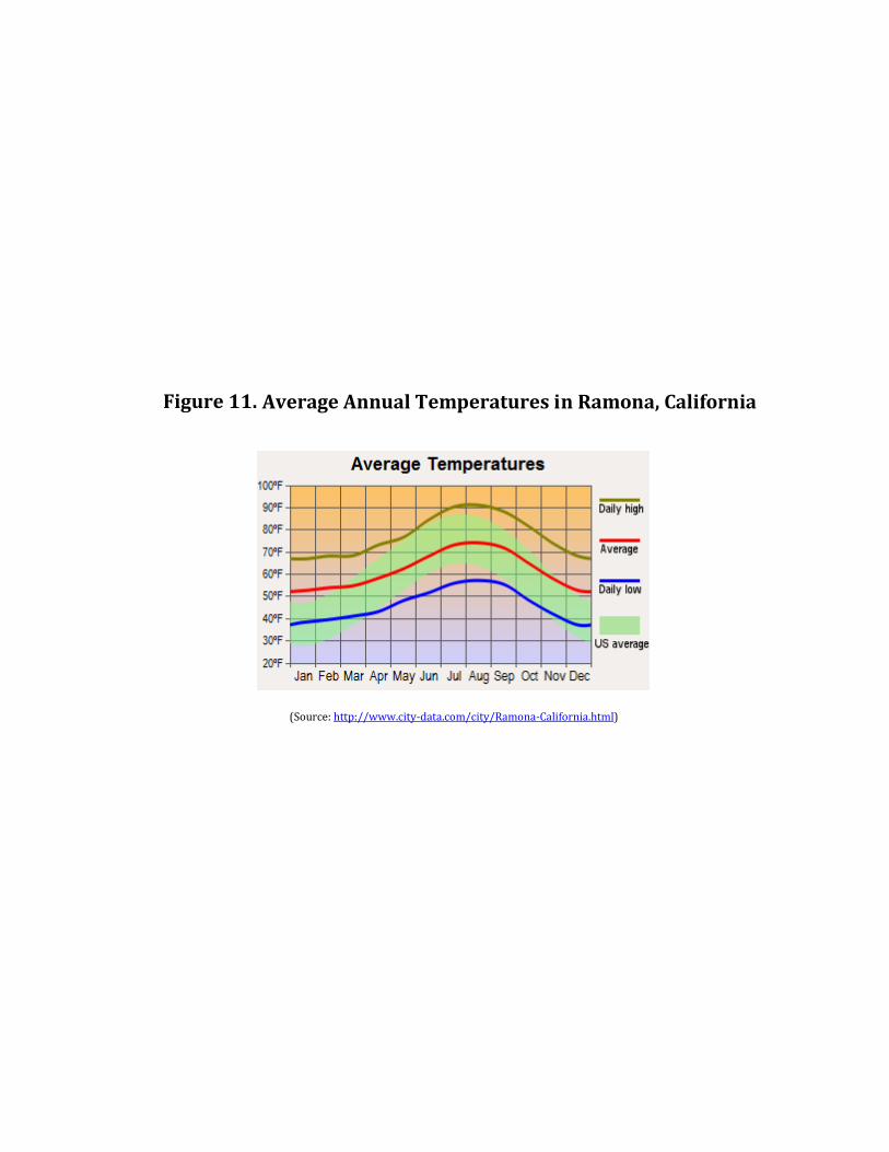
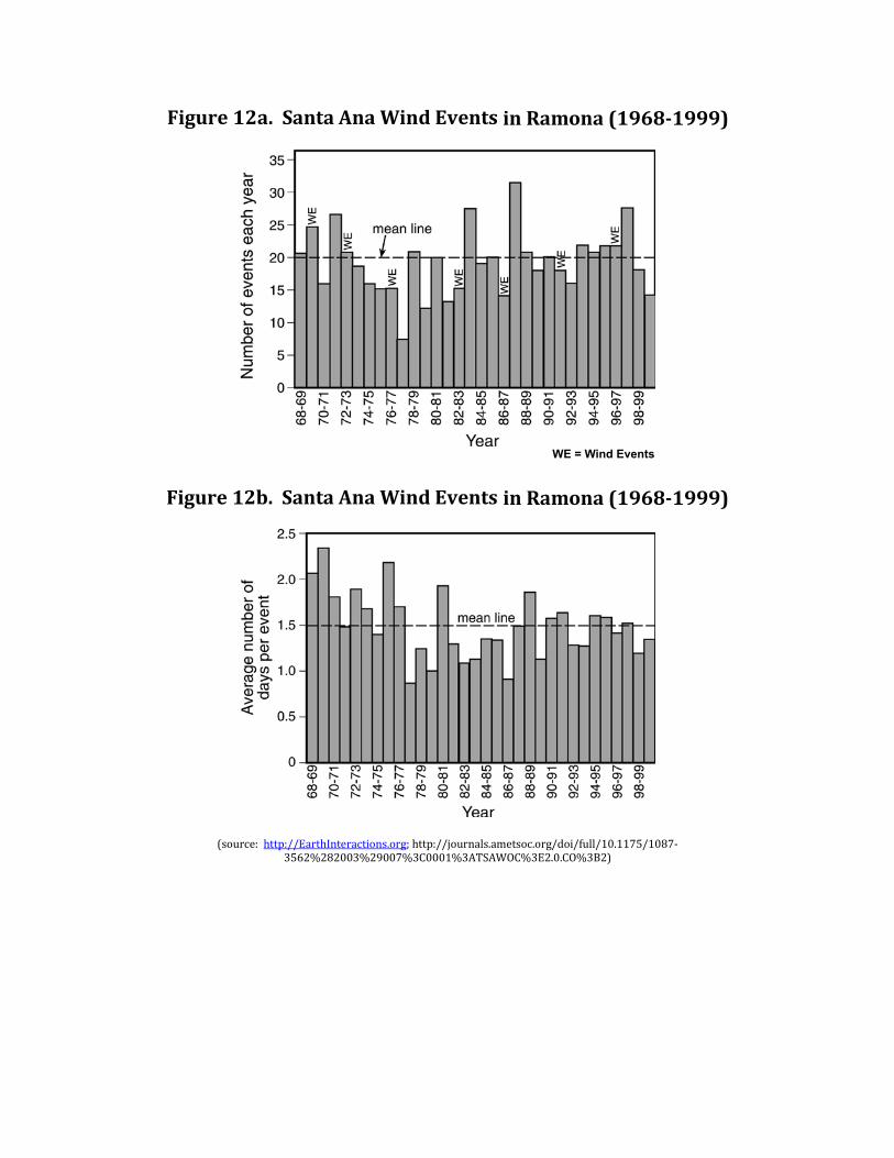
6.2.1 Climate .......................................................................................................................... 6-1 6.2.2 Topography ................................................................................................................... 6-2 6.2.3 Watershed Description ................................................................................................. 6-2 6.2.4 Fire History ................................................................................................................... 6-2 6.2.5 Vegetation Dynamics and Fuel Loads ........................................................................... 6-3
6.4 Fire Response Plan ..................................................................................................................... 6-5 6.4.1 Fire Hazard Evaluation .................................................................................................. 6-6 6.4.2 Emergency Actions and Contacts ................................................................................. 6-7 6.4.3 Roads and Access .......................................................................................................... 6-7
San Diego County Parks and Recreation Contents
Ramona Grasslands Preserve Final Vegetation Management Program iii June 2012
ICF 168.09
6.4.4 Fuel Breaks ....................................................................................................................... 6-8 6.4.5 Emergency Staging Areas ................................................................................................. 6-8 6.4.6 Location of Existing Hydrants .......................................................................................... 6-8 6.4.7 Other Nearby Water Sources ........................................................................................... 6-8
7.2.1 Target Species and Habitats........................................................................................... 7-10 7.2.2 Eradication and Control ................................................................................................. 7-11
Ramona Grasslands Preserve Final Vegetation Management Program iv June 2012
ICF 168.09
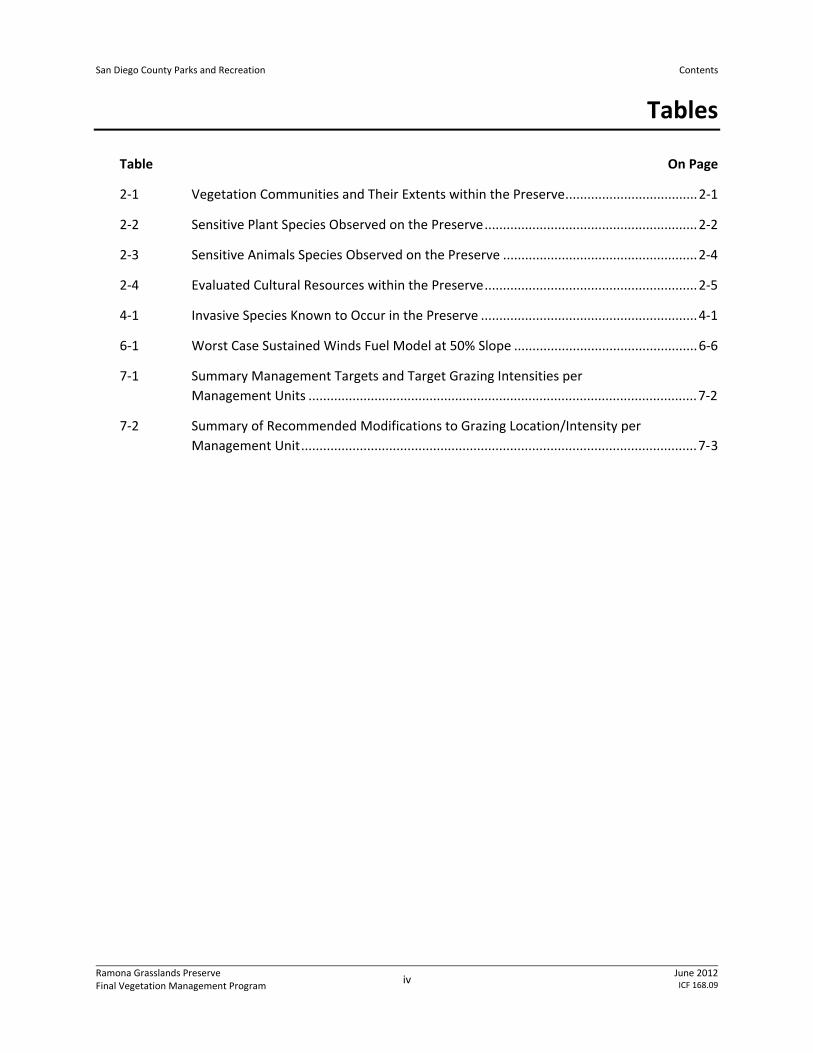
Tables
Table On Page
2-1 Vegetation Communities and Their Extents within the Preserve .................................... 2-1
2-2 Sensitive Plant Species Observed on the Preserve .......................................................... 2-2
2-3 Sensitive Animals Species Observed on the Preserve ..................................................... 2-4
2-4 Evaluated Cultural Resources within the Preserve .......................................................... 2-5
4-1 Invasive Species Known to Occur in the Preserve ........................................................... 4-1
6-1 Worst Case Sustained Winds Fuel Model at 50% Slope .................................................. 6-6
7-1 Summary Management Targets and Target Grazing Intensities per Management Units .......................................................................................................... 7-2
7-2 Summary of Recommended Modifications to Grazing Location/Intensity per Management Unit ............................................................................................................ 7-3
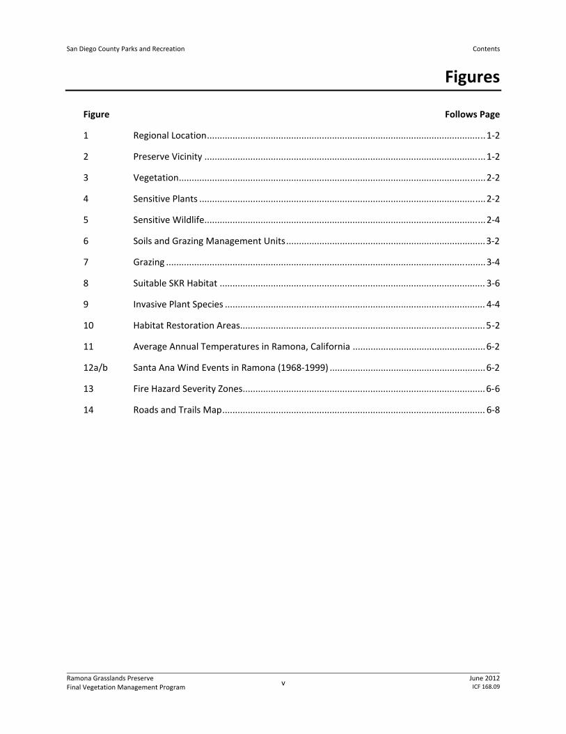
San Diego County Parks and Recreation Contents
Ramona Grasslands Preserve Final Vegetation Management Program v June 2012
9 Invasive Plant Species ...................................................................................................... 4-4
10 Habitat Restoration Areas ................................................................................................ 5-2
11 Average Annual Temperatures in Ramona, California .................................................... 6-2
12a/b Santa Ana Wind Events in Ramona (1968-1999) ............................................................. 6-2
13 Fire Hazard Severity Zones............................................................................................... 6-6
14 Roads and Trails Map ....................................................................................................... 6-8
San Diego County Parks and Recreation Contents
Ramona Grasslands Preserve Final Vegetation Management Program vi June 2012
ICF 168.09
Acronyms and Abbreviations
AMSL above mean sea level AUMs Animal Unit Months BLM Bureau of Land Management CAL FIRE California Department of Forestry and Fire Protection Cal-IPC California Invasive Plant Council CDFA California Department of Food and Agriculture CNPS California Native Plant Society County County of San Diego’s DPR County Department of Parks and Recreation FRMP Framework Resource Management Plan I- Interstate lbs pounds MU Management unit NE northeast NW northwest Preserve Ramona Grasslands Preserve RDM residual dry matter RMWD Ramona Municipal Water District SE southeast SKR Stephens’ kangaroo rat SR- State Route SW southwest USDA U.S. Department of Agriculture VMP vegetation management plan
Ramona Grasslands Preserve Final Vegetation Management Program 1-1
June 2012ICF 168.09
Chapter 1 Introduction
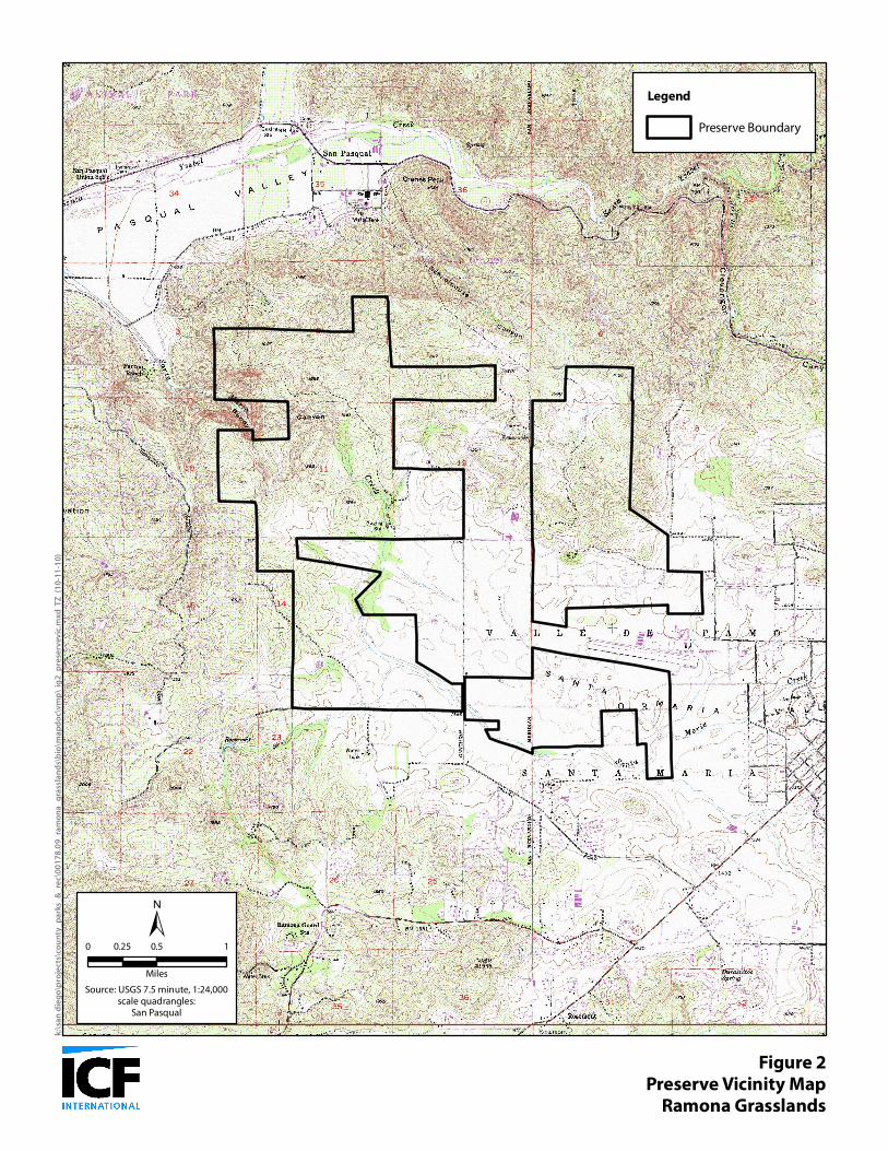
1.1 Purpose and Need The purpose of this vegetation management plan (VMP) is to provide guidance for the management of the vegetative resources of the Ramona Grasslands Preserve (Preserve) through specific and adaptive management practices. The four main components of vegetation management include: invasive species management, habitat restoration, grazing, and fire management. This information is needed to ensure vegetation communities that provide wildlife habitat for shelter and breeding, movement corridors, and foraging opportunities are managed for preservation and function. 1.2 Site Location and Description The Preserve is located in northern San Diego County approximately 6 miles east of Interstate (I-) 15, approximately 1.5 miles south of State Route (SR-) 78, approximately 1.4 miles north of SR-67, and approximately 2.0 miles west of downtown Ramona, California (Figure 1). The Preserve is primarily just west of the Ramona Airport and east and north of Highland Valley Road. Rangeland Road bisects the southern portion of the Preserve and continues north providing vehicular access to a residential development that is adjacent to the northwest (NW) and northeast (NE) portions of the Preserve. The Preserve is within the Santa Maria Valley, which consists of a broad basin surrounded by gentle hills and rocky rises ranging in elevation from approximately 410 meters (1,350 feet) above mean sea level (AMSL) along the valley floor, to over 518 meters (1,700 feet) AMSL in the rocky hills of the northern sections of the Preserve (Figure 2). The NW portion of the Preserve is west of Rangeland Road and is generally north of the Ramona Municipal Water District (RMWD) property. It is characterized by rocky hills bisected by Bandy Canyon, through which the Santa Maria Creek flows. The southwest (SW) portion of the Preserve is generally south and west of the RMWD property and consists of rolling hills with rocky outcrops and areas of oak woodlands that transition into the lower topography grasslands to the south. The southern boundary is Highland Valley Road. Santa Maria Creek also flows through this area. The NE portion of the Preserve is located east of Rangeland Road and north of the Ramona Airport. It is characterized by rocky chaparral-covered hillsides in the north and lower topography grasslands in the south. The southeast (SE) portion of the Preserve is east of Rangeland Road and south of the Ramona Airport. This area consists of low, rolling hills supporting grasslands and rocky outcrops. The Santa Maria Creek channel follows the southern boundary in this area. 1.3 Goals and Objectives Specifically, the goals and objectives of this VMP are to provide management guidelines for the following:
San Diego County Parks and Recreation Chapter 1. Introduction
Ramona Grasslands Preserve Final Vegetation Management Program 1-2 June 2012
ICF 168.09
1. Maximize the extent of appropriate habitat for native target species by the removal or control of nonnative species: Identify invasive species and their locations Investigate and report on control techniques Develop management objectives 2. Provide a framework for the restoration of closed trail areas within the Preserve: Identify closed trails and other areas of potential restoration Identify appropriate restoration goals for each site (i.e., appropriate habitat) Investigate and report on restoration techniques Develop management objectives for the restoration areas 3. Provide a fire management strategy that will include planning for wildland fires: Investigate and report on current fire management practices Provide a description of the fire environment Provide a discussion on fire management methods Develop management objectives through a fire response plan 4. Provide a grazing management plan based on historic, current, and proposed regimes o Provide background and potential benefits of adaptive management through grazing o Determine the current level of grazing, and proposed changes to the existing grazing regime o Describe the grazing benefits to conservation targets including wildlife, hydrological functions, and vegetation communities o Provide grazing-specific directives
San Diego
Escondido
Santee
El Cajon
Poway
Alpine
Ramona
LakesideWinter Gardens
San Marcos
Valley CenterValley Center
San Diego Country EstatesSan Diego Country Estates
Harbison CanyonHarbison Canyon
Hidden MeadowsHidden Meadows
15
815
15
15
15
78
67
52
76
56
78
67
Figure 1Regional Location
Ramona Grasslands
k:\s
an
die
go
\pro
ject
s\co
un
ty_
pa
rks_
&_r
ec\
00
17
8.0
9_r
am
on
a_
gra
ssla
nd
s\b
io\m
ap
do
c\v
mp
\fig
1_
reg
loc.
mxd
TZ
(1
0-1
1-1
0)
Source: ESRI StreetMap North America (2008)
0 2 41
Miles
San Bernardino
Riverside
San Diego
Orange
Los Angeles
Kern
Ramona GrasslandsPreserve
Figure 2Preserve Vicinity Map
Ramona Grasslands
±Source: USGS 7.5 minute, 1:24,000
scale quadrangles:San Pasqual
0 0.5 10.25
Miles
Legend
Preserve Boundary
Ramona Grasslands Preserve Final Vegetation Management Program 2-1 June 2012
ICF 168.09
Chapter 2 Environmental Resources
2.1 Biological Resources The Preserve includes approximately 3,490 acres of native and naturalized habitats including eucalyptus woodland, nonnative woodland, disturbed habitat, developed lands, open water, agriculture, Diegan coastal sage scrub, coastal sage-chaparral scrub, southern mixed chaparral, chamise chaparral, scrub oak chaparral, valley needle grassland, saltgrass grassland, nonnative grassland, alkali marsh, coastal and valley freshwater marsh, emergent wetland, southern coast live oak riparian forest, mule fat scrub, southern willow scrub, open coast live oak woodland, and dense coast live oak woodland (Figure 3). In addition to the vegetation communities listed above, vernal pools and vernal swales occur within the grasslands. The types and acreage of these communities can be seen in Table 2-1. In total, 217 wildlife species have been detected during general surveys, pitfall trapping, avian point counts, camera sampling, and Anabat sampling. Of these species, 40 are considered special-status species by either the federal, state, or local governments. Table 2-1. Vegetation Communities and Their Extents within the Preserve Vegetation Community Acres
San Diego County Parks and Recreation Chapter 2. Environmental Resources
Ramona Grasslands Preserve Final Vegetation Management Program 2-2 June 2012
ICF 168.09
Vegetation Community Acres Mule Fat Scrub 23.26 Southern Willow Scrub 14.26 Subtotal 58.54 Woodlands Nonnative Woodland 1.02 Eucalyptus Woodland 16.10 Open Coast Live Oak Woodland 20.58 Dense Coast Live Oak Woodland 82.13 Subtotal 119.83 Other Land Cover Types Disturbed Habitat 23.88 Agriculture 17.88 Developed Lands 1.50 Subtotal 43.26 Total 3,489.00
2.2 Sensitive Plant Species The following section lists special-status plant species observed within the Preserve (Table 2-2). A special-status plant species is one listed by federal or state agencies as threatened or endangered, is considered to be of special status by one or more special interest groups, such as the California Native Plant Society (CNPS; e.g., List 1, 2, 3, or 4 plants), or is included on the County of San Diego’s Sensitive Plant list (Group A, B, C, or D plants). The locations of these plants are depicted on Figure 4. A complete discussion of sensitive plant species observed within the Preserve may be found in the Baseline Biological Survey Report for the Ramona Grasslands Preserve (ICF 2010). Table 2-2. Sensitive Plant Species Observed on the Preserve Common Name Scientific Name Status1 Ashy spike moss Selaginella cinerascens CNPS 4, SDC-D California adder’s tongue Ophioglossum californicum CNPS 4, SDC-D California large-leafed filaree California macrophylla SDC-B, CNPS 1B Coulter’s saltbush Atriplex coulteri SDC-A, CNPS 1B, MSCP Engelmann oak Quercus engelmannii CNPS 4.2, MSCP Graceful tarplant Holocarpha virgata var. elongata SDC-D, CNPS 4.2, CA endemic Palmer’s sagewort Artemisia palmeri CNPS 4.2 Parish’s brittlescale Atriplex parishii var. parishii SDC-A, CNPS 1B.1, MSCP Peninsular spineflower Chorizanthe leptotheca CNPS 4.2 Rush-like bristleweed Xanthisma junceum CNPS 4.3 San Diego Milkvetch Astragalus oocarpus CNPS 1B.2 San Diego thornmint Acanthomintha ilicifolia FT, CE, SDC-A, CNPS 1B, SDC-A, MSCP Small-flowered microseris Microseris douglasii var. platycarpha SDC-D Southern tarplant Centromadia parryi var. australis SDC-A, CNPS 1B.1, MSCP
61310 Southern Coast Live Oak Riparian Forest (SCLORF)63310 Mule Fat Scrub (MFS)63320 Southern Willow Scrub (SWS)63320 Southern Willow Scrub - Disturbed (SWS-D)64100 Open Water (OW)71161 Open Coast Live Oak Woodland (OCLOW)71162 Dense Coast Live Oak Woodland (DCLOW)79100 Eucalyptus Woodland (EUC)79100 Non-Native Woodland (NNW)
61310 Southern Coast Live Oak Riparian Forest (SCLORF)63310 Mule Fat Scrub (MFS)63320 Southern Willow Scrub (SWS)63320 Southern Willow Scrub - Disturbed (SWS-D)64100 Open Water (OW)71161 Open Coast Live Oak Woodland (OCLOW)71162 Dense Coast Live Oak Woodland (DCLOW)79100 Eucalyptus Woodland (EUC)79100 Non-Native Woodland (NNW)
61310 Southern Coast Live Oak Riparian Forest (SCLORF)63310 Mule Fat Scrub (MFS)63320 Southern Willow Scrub (SWS)63320 Southern Willow Scrub - Disturbed (SWS-D)64100 Open Water (OW)71161 Open Coast Live Oak Woodland (OCLOW)71162 Dense Coast Live Oak Woodland (DCLOW)79100 Eucalyptus Woodland (EUC)79100 Non-Native Woodland (NNW)
61310 Southern Coast Live Oak Riparian Forest (SCLORF)63310 Mule Fat Scrub (MFS)63320 Southern Willow Scrub (SWS)63320 Southern Willow Scrub - Disturbed (SWS-D)64100 Open Water (OW)71161 Open Coast Live Oak Woodland (OCLOW)71162 Dense Coast Live Oak Woodland (DCLOW)79100 Eucalyptus Woodland (EUC)79100 Non-Native Woodland (NNW)
61310 Southern Coast Live Oak Riparian Forest (SCLORF)63310 Mule Fat Scrub (MFS)63320 Southern Willow Scrub (SWS)63320 Southern Willow Scrub - Disturbed (SWS-D)64100 Open Water (OW)71161 Open Coast Live Oak Woodland (OCLOW)71162 Dense Coast Live Oak Woodland (DCLOW)79100 Eucalyptus Woodland (EUC)79100 Non-Native Woodland (NNW)
52300 Alkali Marsh (AM)52440 Emergent Wetland (EMWE)61310 Southern Coast Live Oak Riparian Forest (SCLORF)63310 Mule Fat Scrub (MFS)63320 Southern Willow Scrub (SWS)63320 Southern Willow Scrub - Disturbed (SWS-D)64100 Open Water (OW)71161 Open Coast Live Oak Woodland (OCLOW)71162 Dense Coast Live Oak Woodland (DCLOW)79100 Eucalyptus Woodland (EUC)79100 Non-Native Woodland (NNW)
$Source: ESRI Imagery, 2010. 1 "=2,000 '
k:\sa
n dieg
o\proj
ects\
coun
ty_pa
rks_&
_rec\0
0178
_09_
ramon
a_gra
sslan
ds\bi
o\map
doc\v
mp\fig
4_se
nsitiv
eplan
ts.mx
d TZ
(11-1
5-11)
0 1,000 2,000500Feet
San Diego County Parks and Recreation Chapter 2. Environmental Resources
Ramona Grasslands Preserve Final Vegetation Management Program 2-3 June 2012
ICF 168.09
Common Name Scientific Name Status1 Southwestern spiny rush Juncus acutus var. leopoldii CNPS 4.2 Dwarf peppergrass Lepidium latipes var. latipes Rejected by CNPS Little barley Hordium intercedens SDC-C, CNPS 3.2 Small-leaved morning glory Convolvulus simulans SDC-D, CNPS 4.2 Corresponding San Diego County 1CNPS Codes: (SDC) Code: 1A = Presumed extinct in CA 1B = Rare, threatened or endangered in CA or elsewhere SDC-A 2 = Rare, threatened or endangered in CA, more common elsewhere SDC-B 3 = Need more information about this plant SDC-C 4 = Limited distribution / watch list SDC-D - - - - - - - - - - - - - - - - - - - - - - - - - - 0.1 = Seriously endangered in CA Other Codes: 0.2 = Fairly endangered in CA FT = Federally listed threatened 0.3 = Not very endangered in CA CE = California listed endangered MSCP= Multiple Species Conservation Program
2.3 Sensitive Animal Species There are 41 species of animals, considered sensitive by state or federal resource agencies, or local agencies that are known to occur on the Preserve (Figure 5). There were 52 species of invertebrates including butterflies, skippers, moths, spiders, bees, beetles, worms, scorpions, and centipedes identified during the 2009 baseline surveys of the Preserve (ICF 2010). Species were observed during focused butterfly diversity surveys, herpetological pitfall trapping, and other active surveys. In addition, federally endangered San Diego fairy shrimp (Branchinecta sandiegonensis) was identified by ICF during the 2010 wet season fairy shrimp surveys. San Diego fairy shrimp were confirmed in some of the vernal pools located in the SE portion of the Preserve. No sensitive butterfly species were observed on the site during the 2010 surveys, but there is a moderate potential for the Quino checkerspot butterfly (Euphydras editha quino) to occur on site. A complete discussion of sensitive animal species may be found in the Baseline Biological Survey Report (ICF 2010). Sensitive animals known to occur on the Preserve are listed in Table 2-3 and depicted on Figure 5. In total, 6 amphibian species and 21 reptile species were observed or captured during the 2009 ICF surveys. Of the 27 herpetile species observed, 9 are considered special-status species by federal, state, or local agencies (Figure 5, Table 2-3). In total, 100 bird species were detected during the 2009 ICF surveys. These included year-round residents, winter-only species, breeding species that migrate to the neotropics, and species that are strictly migratory through the Preserve, neither breeding nor wintering there. Of these 16 species are considered sensitive by state or federal resources agencies, or by local agencies (Figure 5, Table 2-3).
San Diego County Parks and Recreation Chapter 2. Environmental Resources
Ramona Grasslands Preserve Final Vegetation Management Program 2-4 June 2012
ICF 168.09
In total, 37 mammal species were detected during the 2009 ICF surveys by general surveys, mammal trapping, camera station sampling, or Anabat sampling. Of these, 14 species have special-status with federal, state, and/or local governments (Figure 5, Table 2-3). Table 2-3. Sensitive Animals Species Observed on the Preserve Taxa / Common Name Scientific Name Status1
San Diego County Parks and Recreation Chapter 2. Environmental Resources
Ramona Grasslands Preserve Final Vegetation Management Program 2-5 June 2012
ICF 168.09
Taxa / Common Name Scientific Name Status1 Pallid bat Antrozous pallidus CSC, SDC2, MSCP Big free-tailed bat Nyctinomops macrotis CSC SDC2 Townsend's big-eared bat Corynorhinus townsendii CSC, SDC2, MSCP Western mastiff bat Eumops perotis CSC, SDC2 Western red bat Lasiurus blossevillii CSC, SDC2 Western yellow bat Lasiurus xanthinus CSC Yuma myotis Myotis yumanensis SDC2 Southern mule deer Odocoileus hemionus fuliginata SDC2, MSCP (S) 1FE = Federally Endangered ST = State of California Threatened CSC = State Species of Special Concern SFP = State of California Fully-Protected SDC1 through SDC2 = San Diego County Species of Concern Lists 1 and 2, respectively MSCP = San Diego County Multiple Species Conservation Plan Target Species VP = Species Subject to San Diego County Vernal Pool Policy 2.4 Cultural Resources The Preserve contains 229 recorded cultural resources, including 211 sites and 18 isolated finds. Due to the large number of resources, they are not presented individually here. Details can be found in the cultural resources inventory report for the Preserve (ICF 2010). Types of cultural resources found in the Preserve include 171 prehistoric archaeological sites, including lithic scatter, ceramic scatters, bedrock milling features, rock features, quarries, and habitation sites; 29 historic archaeological resources including building foundations, trash scatters, wells, roads and trails, dams and water control features, mines, and walls/fences; and 6 multi-component resources with both prehistoric and historic period remains. Previous studies have tested and evaluated only 40 of these archaeological sites (Table 2-4). Of these, 13 have been found significant, including 10 that have been found significant under the County of San Diego’s (County’s) Resource Protection Ordinance. There were 27 sites evaluated as not significant, and the 18 isolates are also not considered significant. However, 5 of the resources evaluated as not significant would be part of a proposed archaeological district related to the ethnographic village of Pa’mu. As such, they too would be considered significant, as contributing elements to the district. The remaining 171 cultural resources have not been formally evaluated and are therefore considered significant. Table 2-4. Evaluated Cultural Resources within the Preserve
Site No. Site Description Study Type Evaluation Results Management Recommendation CA-SDI 7318 Minor bedrock milling site & 1 mano XPI NS No mitigation measures required7319 Minor bedrock milling site XPI NS No mitigation measures required7320 Major bedrock milling site with sparse surface artifacts & limited subsurface deposit PII NS No mitigation measures required
San Diego County Parks and Recreation Chapter 2. Environmental Resources
Ramona Grasslands Preserve Final Vegetation Management Program 2-6 June 2012
ICF 168.09
Site No. Site Description Study Type Evaluation Results Management Recommendation 7321 Major bedrock milling site with limited subsurface deposit PII NS Avoid & preserve. Though not found significant as an individual site, this resource is part of the village of Pa’mu. If the village of Pa’mu is nominated as an archaeological district, it likely would be RPO significant, and this resource would be an element of that district 7322 Major habitation site with sparse surface artifacts & subsurface deposit PII S RPO significant; Avoid & preserve 7324 Major bedrock milling site, possible fertility feature & subsurface deposit PII S Avoid & preserve, or Phase III DR. Note this resource may be RPO significant, but it has not been evaluated for such significance. If it is RPO significant, then the recommendation would be avoid & preserve. Further, it is part of the village of Pa’mu. 7325 Minor habitation site with milling tools & subsurface deposit PII S RPO significant; Avoid & preserve 7326 Minor bedrock milling site with sparse surface artifacts & limited subsurface deposit PII NS Avoid & preserve. Though not found significant as an individual site, this resource is part of the village of Pa’mu. If the village of Pa’mu is nominated as an archaeological district, it likely would be RPO significant, and this resource would be an element of that district 7751 Minor habitation site with subsurface deposit PII S RPO significant; Avoid & preserve 7752 Minor habitation site with subsurface deposit PII NS Avoid & preserve. Though not found significant as an individual site, this resource is part of the village of Pa’mu. If the village of Pa’mu is nominated as an archaeological district, it likely would be RPO significant, and this resource would be an element of that district 7753 Minor habitation site with subsurface deposit PII S RPO significant; Avoid & preserve 7754 Major habitation site with surface artifacts & subsurface deposit PII S Avoid & preserve, or Phase III DR
San Diego County Parks and Recreation Chapter 2. Environmental Resources
Ramona Grasslands Preserve Final Vegetation Management Program 2-7 June 2012
ICF 168.09
Site No. Site Description Study Type Evaluation Results Management Recommendation 7755 Major habitation site with surface artifacts & subsurface deposit PII S RPO significant; Avoid & preserve 7756 Major habitation site with surface artifacts & subsurface deposit PII S RPO significant; Avoid & preserve 7757 Major habitation site with surface artifacts & subsurface deposit PII S RPO significant; Avoid & preserve 7758 Minor habitation site with sparse surface artifacts & subsurface deposit PII S RPO significant; Avoid & preserve 7759 Major habitation site with surface artifacts & subsurface deposit PII S RPO significant; Avoid & preserve 7760 Major bedrock milling site, granary base & sparse surface artifacts XPI NS No mitigation measures required7764 Minor bedrock milling site XPI NS Avoid & preserve. Though not found significant as an individual site, this resource is part of the village of Pa’mu. If the village of Pa’mu is nominated as an archaeological district, it likely would be RPO significant, and this resource would be an element of that district 7767 Major bedrock milling site with sparse surface artifacts & limited subsurface deposit PII NS Avoid & preserve. Though not found significant as an individual site, this resource is part of the village of Pa’mu. If the village of Pa’mu is nominated as an archaeological district, it likely would be RPO significant, and this resource would be an element of that district 7768 Major bedrock milling site with sparse surface artifacts & limited subsurface deposit PII S RPO significant; Avoid & preserve 10258 Major bedrock milling site, sparse debitage scatter, historic rock walls & barbed wire fence XPI NS No mitigation measures required10259 Minor habitation site with sparse surface artifacts & limited subsurface deposit XPI NS No mitigation measures required10261 Minor bedrock milling site XPI NS No mitigation measures required10262 Minor bedrock milling site & serrated biface XPI NS No mitigation measures required11086 Major bedrock milling site with sparse surface artifacts & limited subsurface deposit PII NS No mitigation measures required
San Diego County Parks and Recreation Chapter 2. Environmental Resources
Ramona Grasslands Preserve Final Vegetation Management Program 2-8 June 2012
ICF 168.09
Site No. Site Description Study Type Evaluation Results Management Recommendation 11472 Major bedrock milling site PII NS No mitigation measures required14095 Minor bedrock milling site PII NS No mitigation measures required14096 Minor bedrock milling site PII NS No mitigation measures required15979 Minor bedrock milling site XPI NS No mitigation measures required15980 Minor bedrock milling site XPI NS No mitigation measures required15981 Major bedrock milling site, 1 mano, & sparse historic trash scatter XPI NS Avoid & preserve. Though not found significant as an individual site, this resource is part of the village of Pa’mu. If the village of Pa’mu is nominated as an archaeological district, it likely would be RPO significant, and this resource would be an element of that district 16076 Minor bedrock milling site XPI NS Avoid & preserve. Though not found significant as an individual site, this resource is part of the village of Pa’mu. If the village of Pa’mu is nominated as an archaeological district, it likely would be RPO significant, and this resource would be an element of that district 16077 Minor bedrock milling site XPI NS No mitigation measures required16078 Minor bedrock milling site XPI NS No mitigation measures required16079 Minor bedrock milling site XPI NS No mitigation measures required16080 Minor bedrock milling site XPI NS No mitigation measures required16081 Minor bedrock milling site XPI NS No mitigation measures required17171 Major habitation site with surface artifacts & subsurface deposit XPI S Avoid & preserve, or Phase II TE 18918 Minor bedrock milling site XPI NS No mitigation measures requiredStudy type: PI = Phase I survey; XPI = extended Phase I testing; PII = Phase II testing Evaluation results: NS = not significant; S = significant Management Recommendation: TE = test & evaluation; DR = data recovery
Ramona Grasslands Preserve Final Vegetation Management Program 3-1 June 2012
ICF 168.09
Chapter 3 Grazing Management
A managed grazing program, supplemented with other management actions as necessary to achieve management goals, is considered the most cost effective approach to maintaining existing high value biological resources. The current grazing regime of the private cattle operations in the Preserve is beneficial to several high priority species utilizing the loamy grasslands, e.g., Stephens’ kangaroo rat (SKR) and raptors. Modifications to the current grazing regime, via managed grazing within specifically delineated grazing management units, was recommended by CBI (2004) to also enhance resource values in the clayey grasslands. The use of managed grazing to benefit vernal pools as discussed by CBI (2004), Marty (2005), and Pyke and Marty (2005) provide recent experimental evidence demonstrating the benefits of grazing to vernal pool systems. Managed grazing applies an adaptive management approach. Components of experimental design typically include controls and replication, randomization, and interspersion of treatments (Hurlbert 1984). However, in the Preserve it will be difficult to design formal experiments for many target resources. For example, due to their distribution, it is not practical to construct enclosures around all vernal pools, vernal pool complexes, or clay soil units to replicate even a single grazing treatment/control experiment, let alone evaluate a variety of grazing intensity and timing treatments. However, comparing the responses of target resources to alternative management actions that can be distributed across different management units, even if conducted outside the framework of a controlled experiment, can increase land managers’ understanding of ecosystem variability and response. In addition, because of the scale of management units are much larger than distributions of some resource types (e.g., alkali playas and some vernal pools are contained within a loamy grassland management unit), it may be necessary for the habitat manager to regulate grazing at a smaller scale within the management unit (e.g., use of temporary or electric fencing) or employ alternative approaches to achieve management objectives. Therefore, the objective of the grazing management program is to establish biological goals for a workable and cost-effective management program for maintaining and restoring the Preserve’s ecosystem, and to provide management prescriptions based on existing conditions and our current understanding of this ecosystem. It is important to recognize that an experienced habitat manager must refine grazing prescriptions, consistent with these goals, as management actions are implemented, variations in weather are accounted for, responses to management observed, and understanding of the ecosystem is improved. Natural variations in environmental conditions are constantly in flux, and the desired biological responses to management actions may require many years to achieve. Thus, the long-term monitoring program is a fundamental component of the adaptive management of the Preserve, and will document the ranges of natural variation within the different grasslands communities and the ecosystem as a whole, as well as the differential responses to human-controlled management prescriptions. 3.1 Grazing History The majority of the core grasslands area has been used for cattle grazing for many years, with limited improvements such as perimeter fencing and wells installed over the years. The entire
San Diego County Parks and Recreation Chapter 3. Grazing Management
Ramona Grasslands Preserve Final Vegetation Management Program 3-2 June 2012
ICF 168.09
Preserve is currently under lease to Tellam and Tellam Cattle for cattle ranching. The Tellam and Tellam Cattle operation consists of year-round cattle grazing, with rotation and rest periods. Stocking rates have been established on an annual basis, primarily based on weather and forage conditions. Bulls are added to the range around the first week of December to begin siring calves, with calving starting in mid-September of the following year. Calves are removed the following summer when the forage begins losing nutritional value. Supplemental feed is provided during summer (molasses supplement for increased protein and improved digestion of the dry forage), when the pregnant cows are on the range, which is otherwise low in nutrition once the vegetation dries out. The quantitative measurements of food production by measuring residual dry matter (RDM) was historically performed in the grassland areas of the Preserve and more recently measured annually in order to modify grazing regime based on results. RDM levels correlate to desired conditions for SKR, raptor foraging habitat, and vernal pool systems. 3.2 Geology and Soils The Santa Maria Valley is located within the western zone of the Peninsular Ranges Batholith. Granodiorite outcrops from this uplifted structure occur across the grasslands of the Santa Maria Valley and dominate the hilltops, where relatively deep, well-drained soils of decomposed granodiorites slope away from them. Lower-lying areas tend to support heavier clay soils, with shallow or surface expression of clay hardpans, and these soils sometimes develop characteristic vernal pool/mima mound topography. Gabbro outcrops can also be found scattered throughout the grasslands and influence plant associations. Several general soil associations are represented within the Preserve: acid igneous, Bonsall, Bonsall-Fallbrook, Bonsanko, Cieneba, Cieneba-Fallbrook, Fallbrook, Las Posas, Placentia, Ramona, Tujunga, Visalia, and Vista (Figure 6) (USDA 1973). The characteristic features of these associations are described below.
Acid igneous rock land is rough broken terrain. The topography ranges from low hills to very steep mountains. Large boulders and rock outcrops cover 50 to 90% of the total area. The soil material is loam to loamy coarse sand in texture and is very shallow over decomposed granite or basic igneous rock. This soil type is mapped primarily on a large hill near the central section of the NW portion. The Bonsall soil series (BmC) is characterized by moderately well-drained, shallow to moderately deep sandy loams that have a heavy clay loam subsoil with slopes from 2 to 15%. These soils are mapped in the lower elevation areas of the southern areas. The Bonsall-Fallbrook soil series (BnB) is characterized as a complex of sandy loams with slopes from 2 to 50%. This series is a mixture of soils with about 50% Bonsall sandy loam and 45% Fallbrook sandy loam. These soils appear in undulating uplands, where the Bonsall soils occupy the swales and Fallbrook soils occupy the low mounds and ridges. This soil series is mapped in the southeastern corner of the SW portion, the southern section of the NE portion, and in the northern section of SE portion. The Bosanko soil series (BsC) is characterized as well-drained, moderately deep clays from materials derived from acid igneous rock with slopes from 2 to 30%. These soils are found on
RANG
ELAN
D RD
MONTECITO WAY
MONTECITO RD
HIGHLAND VALLEY RD
ARCHIE MOORE RD
HIGHLAND VALLEY RD
FaD2
VsCCnE2
VsC
VaB
FaE2
FaD2
VaA
VvD
FeE
VaBPeC
BsC
FaD2
FaD2
CmE2
LrE2
BmC BsC LpC2RaC2 PeC
LrE2BsCFaD2
LrE2
BnB
BlC2
PeC
CmrG
FeE
FaE2
AcG
VaB
RaC FaD2 CmrGRaD2
CmE2
FaD2CmE2
FeE
FaE2RaC2
FaD2 FeC
ClE2ClE2
AcG
VsD FaB
FaD2
VsC
FeE2
CmE2LrE
FaD2
LpD2FaE2FeE
FaC2
VsD2
BnB
VsD
CnG2
VsD2
CnE2
FaD2
VsD
VaA
VsD2
RaC VvE RaC2
CmE2
FaD2FaD2 PeC
VsDCmE2
VvDVsCRaD2
VvD
PeC2VaB
VsC
BmCBsC
LpC
FeEPeC2
BmC VvD
LpC2
FeE
VaA
PeCVaAFaD2
CnG2
CmE2
FaD2
VaB
FaE2
TuB
AcG
LrG
2B
3D
1C
3E
3C
2A
1B
3B
3A
4A
4B
4B 1A
2B
5
4C
1A
Figure 6Soils & Grazing Management Units
Ramona Grasslands Preserve
$1 " = 2,000 '
0 2,0001,000Feet
San Diego County Parks and Recreation Chapter 3. Grazing Management
Ramona Grasslands Preserve Final Vegetation Management Program 3-3 June 2012
ICF 168.09
uplands that are undulating to hilly. This series is mapped on the SE portion as well as in the southeastern section of the SW portion. The Cieneba soil series (ClD2, ClE2, CmE2, CmrG) is characterized as coarse sandy and rocky sandy loams with slopes from 5 to 75%. They are typically described as excessively drained shallow soils that are weathered in place from granite outcrops found in the adjacent uplands. These soils are mapped primarily in the northern sections of the northern portions. The Cieneba-Fallbrook soil series (CnE2, CnG2) is characterized as a soil complex with about 55% Cieneba coarse sandy loam and 40% Fallbrook sandy loam, with slopes of 9 to 65%. This soil is mapped on the northern areas. The Fallbrook soil series (FaB, FaC2, FaD2, FaE2, FeC, FeE, FeE2) is characterized as sandy to rocky sandy loams with slopes from 2 to 30%. These soils are typically moderately deep and well drained, and are weathered in place from granodiorite. This soil is mapped in scattered patches throughout the Preserve. The Las Posas soil series (LpC, LpC2, LpD2) is characterized as fine sandy loams and stony fine sandy loams with clay subsoil with 2 to 65% slopes. These soils are well-drained, moderately deep, and are formed from materials weathered from basic igneous rocks. This soil is mapped in scattered patches throughout the Preserve. Las Posas soils are considered mafic and are known to support sensitive plants population within the County of San Diego. However, within the Preserve no special-status plant populations were observed on these soils. The Placentia soil series (PeC, PeC2) is characterized as moderately well-drained sandy loams that have sandy clay subsoil, with 0 to 9% slopes. They are moderately well-drained soils made from granitic alluvium and are found on old alluvial fans. This soil is mapped in scattered patches throughout the Preserve. The Ramona soil series (RaB, RaC, RaD2) is characterized as well-drained, very deep sandy loams that have a sandy clay loam subsoil with slopes of 0 to 30%. They are formed from granitic alluvium and are found on terraces and alluvial fans. This soil is mapped in patches on the northern portions of the Preserve. The Tujunga soil series (TuB) is characterized as deep, excessively drained sands derived from granitic alluvium with slopes of 0 to 5%. This soil is mapped along the Santa Maria Creek on the southern and NW portions of the Preserve. The Visalia soil series (VaA, VaB) is characterized as sandy or coarse sandy loams with slopes from 0 to 15%. These are moderately well-drained soils derived from granitic alluvium and are typically found in alluvial flood plains and fans. This soil is mapped in areas of lower topography throughout the Preserve. The Vista soil series (VsC, VsD, VsD2, VvD, VvE) is characterized as rocky coarse sandy loams with slopes of 5 to 65%. These are well-drained, moderately deep to deep soils derived from granodiorite or quartz diorites. Patches of this soil are mapped throughout the Preserve.
San Diego County Parks and Recreation Chapter 3. Grazing Management
Ramona Grasslands Preserve Final Vegetation Management Program 3-4 June 2012
ICF 168.09
3.3 Grazing Management Units Within the Preserve, there are four major biological elements around which the managed grazing program has been developed: loamy grasslands, clayey grasslands, Santa Maria Creek corridor (riparian corridor), and vernal pools/swales. The delineation of grazing management units presented in the Framework Management and Monitoring Plan (CBI 2004) was based on the distribution and differential response to grazing of the various conservation targets and existing fencing in the Preserve. Additional fencing to create these units was installed by the County Department of Parks and Recreation (DPR) in the summer of 2006. Expansion of existing management units, the addition of new management units, and fencing is proposed (Figure 7). The locations of the previously established management units and the proposed management units in the Preserve are shown in Figure 7. Management Units 1A, 1B, and 1C are units located within the Santa Maria Creek corridor. The previously delineated portion of Unit 1A, as well as Units 1B and 1C have been fenced to exclude cattle for passive revegetation of riparian habitat within the creek and to ensure that impacts do not occur on breeding arroyo toad. The portion of Unit 1A within the NW portion is not fenced due to topographical constraints. Management Unit 2A consists of loamy and clayey grasslands south of the airport in the SE portion of the Preserve, Unit 2B consists of loamy grasslands north and south of the airport in the SE and NE portions of the Preserve; and Units 3A, 3B, 3C, 3D, and 3E consist of both loamy and clayey grassland occurring in the southern portions of the Preserve west of Rangeland Road and in the southeastern corner of the Preserve. Management Unit 3B consists primarily of the SW portion of the Preserve and includes loamy grasslands where SKR were detected in 2009 and 2011 and small amounts of clay soils along the southern boundary of the management unit (ICF 2010). Three new management units have been proposed in the northwest and northeast portions of the Preserve: 4A, 4B, and 4C. Management Unit 4A consists of loamy grasslands in the southeast corner of the NW portion of the Preserve. Management Unit 4B consists mainly of southern mixed chaparral with patches of loamy grasslands. Management Unit 4C consists of southern mixed chaparral, disturbed southern mixed chaparral, and coastal sage scrub and is not proposed for managed grazing. Management Unit 5 is not currently grazed and is not proposed for grazing. The management unit consists of upland habitats that are recovering from the 2007 Witch Fire, or consist of isolated patches of nonnative grassland that cannot be accessed by cattle grazers. As described below, major biological elements and individual management targets are distributed among these grazing management units and grazing intensity (a combination of number of cattle and length of time in a unit) will be managed within various grazing management units for specific resource targets. 3.3.1 Loamy Grasslands The Preserve supports large areas of loamy soil types (Units 2A–2B, 3A, 3B, 3D, 4A, and 4B; Figure 6) and are dominated by nonnative annual grasses and forbs, including saltgrass (Distchlis spicata), filaree (Erodium sp.), rip gut brome (Bromus diandrus), slender wild oat (Avena barbata), and foxtail chess (Bromus madritensis ssp. rubens). Unit 4B has smaller areas of nonnative annual grasses and forbs compared to the other units. While not an accepted vegetation community class, these are
&-
&-
&-
!? !?
!?!?
!?!?
!?
!?
!?
!?
!?
!?!?
!?
!? !?
!?
!?
Rang
eland
Roa
d
Highland Valley Road
Archie Moore Rd
Montecito Way
1A
2B
3D
1C3E
3C
2A
1B
3B3A
4A
4B
4B1A
2B
4C*
5**
Figure 7Grazing
Ramona Grasslands
Legend
Preserve Boundary
Grazing Management Units
!? Gate
Fence
Hydrologic Features
&- Drinker
&- Well
Pond
$Source: ESRI Imagery, 2009. 1 "=2,200 '
k:\sa
n dieg
o\proj
ects\
coun
ty_pa
rks_&
_rec\0
0178
_09_
ramon
a_gra
sslan
ds\bi
o\map
doc\v
mp\fig
7_gra
zing.m
xd T
Z (11
-15-11
)
0 1,000 2,000500Feet
* MU 4C is not proposed for managed grazing.** MU 5 is not proposed for grazing.
San Diego County Parks and Recreation Chapter 3. Grazing Management
Ramona Grasslands Preserve Final Vegetation Management Program 3-5 June 2012
ICF 168.09
referred to herein as loamy grasslands, a useful description of these habitats for management purposes. Although dependent on grazing intensity and annual rainfall, loamy grasslands generally have a higher proportion of forbs and more bare ground than clayey grasslands (CBI 2007) and provide suitable habitat for SKR. Suitable habitat for SKR is located in the Preserve on well drained soils with relatively high cover of annual forbs and bare ground (Figure 8). The distribution of SKR within this area of suitable habitat is patchy, and density is variable from year to year depending on rainfall and resulting vegetation growth, grazing intensity, and underlying soil characteristics (CBI 2007). Following drier winters, SKR expand into areas of lower quality habitat within the loamy grasslands as the structure of these areas remains more open relative to wetter years. Following wetter winters when lower habitat quality areas are overwhelmed by dense growth of annual grasses, the SKR population contracts to the highest quality areas, i.e., those areas where the amount of bare ground and annual forb cover consistently remain the highest. The SKR population in the Preserve during the 2005–2006 survey period was considered to be fairly low in abundance due to the high biomass of annual grasses following the wet winter of 2005 (CBI 2007). Within the high quality core SKR habitat a 300 to 700 pounds per acre target RDM value shall be maintained to ensure the loamy grasslands continue to support SKR. Higher RDM values are acceptable within the loamy grasslands that do not support SKR. The loamy grassland habitats in the Preserve also support a diverse raptor community, including wintering raptors such as ferruginous hawk that require similar open grassland habitat conditions that benefit from moderate grazing regimes (CBI 2007). As many as 22 ferruginous hawk winter every year in the Preserve, the largest wintering concentration of these rare hawks in San Diego County (CBI 2007). Wintering bird habitat value is related to food availability rather than nesting sites (Plumpton 1998). A variety of other raptors utilize the Preserve for wintering and nesting (CBI 2007), including Cooper’s hawk, red-tailed hawk, red-shouldered hawk, American kestrel, white-tailed kite, barn owl, great-horned owl, and turkey vulture. A pair of golden eagles nests off site in Bandy Canyon, and they are known to forage in the Preserve (WRI 2006 and ICF 2010). The majority of the loamy grasslands area continues to be used for cattle grazing, and cattle tend to congregate more heavily in some portions of the Preserve than others. In particular, cattle grazing appears to be most intense near rocky swales, where more mesic conditions make for better forage, and in the grasslands located in the NE portion of the Preserve, close to the effluent spray fields of the RMWD. The spray fields are supported by a subsurface pipe network and sprinkler irrigation system. The much richer forage associated with this irrigation and associated nutrient enrichment is highly attractive to cattle. According to the local grazing leaseholder (Tellam pers. comm.), economically viable cattle ranching in the grasslands is largely dependent on the increased productivity provided by these spray fields. As described above, loamy grasslands support potential habitat for SKR (confirmed present in Units 2B and 3B by ICF in 2009) and raptors such as ferruginous hawks (WRI 2006 and observed in Unit 2A by ICF in 2009). These management units are generally characterized by a relatively open vegetation cover, with a high proportion of bare ground and low amounts of thatch. The southern portion of Management Unit 2A, the eastern portion of 2B, and the northeastern portion of 3A have denser and taller vegetation, including patches of southern tarweed. The primary management emphasis for loamy grassland habitats in the Preserve is long-term maintenance of conditions suitable for SKR and raptors, and maintaining viable populations of rare alkali playa plant species.
San Diego County Parks and Recreation Chapter 3. Grazing Management
Ramona Grasslands Preserve Final Vegetation Management Program 3-6 June 2012
ICF 168.09
Based on the annual RDM analysis conducted within the Preserve in 2008 through 2011, it is clear that the structure of grasslands in the Preserve (e.g., density, height, and biomass of grasses and forbs and amount of bare ground) can vary substantially from year to year depending on weather patterns, and that species such as SKR exhibit population fluctuations in response to these conditions. SKR appear adapted to this inter-annual variation in habitat quality, so that management actions should focus on maintaining appropriate conditions over the long-term, rather than attempting to maintain a consistent grassland structure each year. As long as grazing is maintained in the Preserve, the distribution and abundance of SKR and other loamy grassland species is expected to naturally expand and contract in response to annual rainfall and changing habitat conditions (CBI 2007). 3.3.2 Clayey Grasslands The grasslands occurring on areas of the Preserve supporting clay soils (portions of Units 2A and 3A–3D, Figure 6), referred to herein as clayey grasslands, tend to have the same general species composition as do loamy grasslands. However, they support a greater abundance of native grasses and forbs, including small flowered bindweed (Convolvulus simulans), California large-leaf filaree (California macrophylla), dwarf plantain (Plantago erecta), foxtail chess, slender wild oat, rip gut brome, common tarweed (Deinandra fasciculatum), and graceful tarplant (Holocarpha virgata ssp. elongata). The only known location in the Preserve of the federally threatened and state endangered San Diego thornmint (Acanthomintha ilicifolia) is in Bosanko clay soils within Unit 3D in the southeastern corner of the Preserve. Clayey grasslands have a higher proportion of grass species cover than do loamy grasslands. Grazing also appears to be less intense in the low-lying clay soils in the Preserve (AECOM 2010). Tellam and Tellam Cattle operation has been stocking Unit 2A with 100 Animal Unit Months (AUMs) 5 to 7 months out of the year in 2009 and 2010; however, the cows seem to congregate in the RMWD property spray fields adjacent to these Units. Clayey grasslands support the majority of vernal pools in the Preserve, including the major complex south of the airport that supports sensitive species such as San Diego fairy shrimp and western spadefoot toad (ICF 2010). Purple needlegrass and several rare native plant species, including San Diego thornmint, round-leaved filaree, small-flowered morning glory, and graceful tarplant also occur in clayey grasslands in the Preserve (CBI 2007, ICF 2010). The primary management emphasis for this biological element is to reduce the cover of nonnative annual grasses and forbs and thatch, which should enhance native plant species cover and hydrologic function of vernal pools. The RDM target for the clayey grasslands is a value of 800 to 1,500 pounds per acre. 3.3.3 Santa Maria Creek Corridor Santa Maria Creek Corridor (Units 1A–1C) supports riparian scrub and oak woodland, oak riparian forest, alkali marsh, and freshwater marsh habitats. Portions of Santa Maria Creek west of Rangeland Road support perennial surface water, whereas the remainder supports intermittent or ephemeral stream flow depending on topography. Flat areas supporting higher ground water due to a restrictive layer of clay or rock support surface water longer than areas with well-drained soils or steep topography. The topography generally trends from flatter areas of more sand to the east, to steeper areas with rock to the northwest. The variation in soils and topography throughout the creek corridor allows for areas of braided channels, small pools and waterfalls, and patchy vegetation communities.
!? !?
!?!?
!?!?
!?
!?
!?
!?
!?
!?!?
!?
!? !?
!?
!?
Rang
eland
Roa
d
Highland Valley Road
Archie Moore Rd
Montecito Way
1A
2B
3D
1C3E
3C2A
1B
3B 3A
4A
4B
4B1A
2B
4C*
5**
Figure 8Suitable SKR Habitat
Ramona Grasslands
Legend
Preserve Boundary
Grazing Management Units
SKR Density Classes 2005-2006
Low
Moderate
Trace/Unoccupied
!? Gate
Fence
Hydrologic Features
&- Drinker
&- Well
Pond
$Source: ESRI Imagery, 2009. 1 "=2,200 '
k:\sa
n dieg
o\proj
ects\
coun
ty_pa
rks_&
_rec\0
0178
_09_
ramon
a_gra
sslan
ds\bi
o\map
doc\v
mp\fig
8_sk
r&mu
.mxd
TZ
(11-16
-11)
0 1,000 2,000500Feet
* MU 4C is not proposed for managed grazing.** MU 5 is not proposed for grazing.
San Diego County Parks and Recreation Chapter 3. Grazing Management
Ramona Grasslands Preserve Final Vegetation Management Program 3-7 June 2012
ICF 168.09
The riparian scrub and forest, and oak woodland communities, along the entire creek provides habitat for riparian birds and raptors. Additionally, the sandy soils and creek morphology west of Rangeland Road provide habitat for arroyo toad and western spadefoot. The entire creek south of the RMWD Property has been fenced to exclude cattle grazing for passive revegetation of riparian habitat. Santa Maria Creek north of the RMWD property has not been fenced. Much of the topography (including rocky outcrops) does not make fencing in this area feasible. Grazing in the eastern area of the NW portion of the Preserve is currently limited to 10 bulls June through November each year and a drinker is available. Cattle grazing can prevent the overgrowth of riparian vegetation within Unit 1A. Cattle will keep riparian vegetation at a mid-successional range and is beneficial to promote breeding habitat for arroyo toad (Hancock 2009). 3.3.4 Vernal Pools and Swales Vernal pools are scattered throughout the Preserve, but are concentrated in the southern portions of the Preserve, east and west of Rangeland Road. The pools located south of the Ramona Airport in the SE portion of the Preserve display a distinct, although shallow, mima mound topography. The length of ponded conditions in the vernal pools monitored in 2005 varied substantially, but pools in this area tended to be the least persistent (RECON 2005 in CBI 2007). Many of the vernal pools in other areas of the Preserve appear to be associated with swale features that have been physically modified by historic land use changes (e.g., dry farming, airport runway construction, and impoundment of the swales) that have altered swale hydrology and morphology. The Ramona vernal pools are part of the Inland Valley Management Area of the Southern California recovery plan (USFWS 1998). The vernal pools south of the airport are associated with Placentia soils, while many of the other pools in the Preserve are associated with Bonsall, Fallbrook, or Bosanko soils. Vernal pools in the Preserve are variable in their species composition (CBI 2007), but cover in the center portions of the pools is typically dominated by Italian ryegrass, Mediterranean barley (Hordeum marinum), pale spike-sedge (Eleocharis macrostachya), iris-leaved rush (Juncus xiphioides), dwarf woolly-heads (Psilocarphus brevussimus), owl’s clover (Castilleja densiflora), and grass poly (Lythrum
hyssopifolium). Outside of the deepest parts of the pools, nonnative annual grass and forbs, including long-beak filaree, soft chess (Bromus hordeuceus), slender wild oat, and hairy rat-tail fescue (Vulpia myuros), are increasingly important contributors to vegetative cover. Several rare and sensitive native species were detected in the vernal pools during 2005, 2006, and 2009–2010 field surveys, including southern tarplant, small-flower microseris (Microseris douglasii ssp. platycarpha), coast popcornflower (Plagiobothrys undulatus), and dwarf peppergrass (Lepidium latipes). Little mousetail (Myosurus minimus ssp. apus) and the federally threatened spreading navarretia (Navarretia fossalis) have been detected in the vernal pools in the Ramona area but were not detected in the Preserve during field surveys in 2005, 2006, 2009, and 2010. The federally endangered San Diego fairy shrimp is well distributed in the vernal pools and swales in the Preserve (FAA 2003, RECON 2005 in CBI 2007), and has also has been detected in portions of Santa Maria Creek (EDAW 2003). The 2010 wet season fairy shrimp surveys confirmed the presence of San Diego fairy shrimp in some of the vernal pools located in the SE portion of the Preserve; however, fairy shrimp were not observed in 2010 in the pools located in the southwest portion of the Preserve (ICF 2010). No other fairy shrimp species were detected in the Preserve. The distribution of fairy shrimp among vernal pools may be related to vernal pool hydrology, and some
San Diego County Parks and Recreation Chapter 3. Grazing Management
Ramona Grasslands Preserve Final Vegetation Management Program 3-8 June 2012
ICF 168.09
vernal pools apparently do not hold water long enough for fairy shrimp to reach maturity in some years (EDAW 2002, EDAW 2003, Ecological Ventures California 2003). However, given natural variation in the morphology of vernal pools, variation in habitat suitability of fairy shrimp is to be expected. Western spadefoot toad and western toad were observed in several of the vernal pools located in the SW portion of the Preserve during focused surveys conducted in 2010 by ICF. The primary management emphasis for vernal pools in the Preserve is to reduce the cover of nonnative annual grasses and forbs and thatch, which should enhance native plant species cover and hydrologic function of the vernal pools. Vernal pool watershed function in other vernal pool systems has been maintained by decreasing thatch buildup through cattle grazing (Marty 2005, Pyke and Marty 2005). 3.4 Conservation Targets within Grazing Management
Units 3.4.1 Target Wildlife Species
Stephens’ Kangaroo Rat Moderate to heavy timed grazing has been shown to be beneficial to SKR by increasing the abundance of preferred food source (annual forbs), creating bare ground patches for foraging and dust baths, and by creating very sparse thatch during summer–fall to facilitate foraging, movement, and forb regeneration. Within high quality core SKR habitat (northern portion of Management Unit 2B) grazing will be managed to a target RDM of 300 to 700 pounds per acre and management units with low quality SKR habitat (2A, 2B [south of Ramona Airport], and 3A) will be managed to a target RDM level of 800 to 2,100 pounds per acre (Figure 8). Arroyo Toad The upland habitat and riparian corridor in Management Unit 1A will be managed for arroyo toad. The encroachment of nonnative weedy plants has played a role in the decline of arroyo toad (USFWS 2011). Arroyo toads prefer shallow pools and open, sandy stream terraces. They use adjacent upland habitat for feeding and shelter in the nonbreeding seasons (USFWS 2011). Natural succession of riparian species can create a loss of breeding habitat for arroyo toad. In addition, dense riparian vegetation will decrease breeding activity (Hancock 2009). Cattle grazing can prevent the overgrowth of riparian vegetation. Cattle will keep riparian vegetation at a mid-successional range (Hancock 2009). Grazing is proposed within all portions of Management Unit 1A for 2 to 4 months out of the year (January to February and August to September) to reduce the weedy grasses in the upland area and keep the riparian vegetation at a mid-successional range. San Diego Fairy Shrimp Moderate timed grazing may benefit this species by improving vernal pool/swale systems through exotic plant reduction, and by maintaining hydpoperiod by reducing vegetation density and thatch. Additionally, cattle and other wildlife can disseminate fairy shrimp cysts between pools.
San Diego County Parks and Recreation Chapter 3. Grazing Management
Ramona Grasslands Preserve Final Vegetation Management Program 3-9 June 2012
ICF 168.09
Management Units 2A and 3A [southeastern area] support loamy grasslands with scattered vernal pools, and grazing will be managed to a target RDM of 800 to 2,100 pounds per acre. The southeast areas of Management Units 3B and 3D support loamy grasslands with areas of clay soils that can support vernal pools, and grazing will managed to a target RDM of 400 to 2,100 pounds per acre. Management Unit 3C supports the highest density of vernal pools compared to the other management units in the Preserve, and grazing will be managed to a target RDM of 800 to 1,500 pounds per acre. Grazing will be timed to occur in the fall and early winter when nonnative annual grasses have germinated but prior to the inundation within the vernal pools. Grazing shall not occur after vernal pool inundation to avoid trampling of fairy shrimp. Raptors Moderate grazing helps maintain open, forb-dominated foraging areas with abundant gophers and other prey. Management Units 3B [western area], 4A, and 4B consist of loamy soils and mixed chaparral communities that will be managed for raptor foraging. Grazing will be managed within these units at a target RDM of 400 to 2,100 pounds per acre.
3.4.2 Target Hydrological Functions
Surface Water Quality Cattle will be restricted from the Santa Maria Creek riparian corridor in Management Unit 1A for eight (8) months out of the year to allow for passive restoration of riparian/wetland vegetation, to maintain stabilized steam banks, and to reduce pollutants (cattle urine and feces) from entering the creek. Management Units 1B and 1C will be closed to cattle for the entire year until it is determined through RDM monitoring that grazing is required. The portion of Santa Maria Creek in the NW portion of the Preserve will not be fenced. Much of the topography (including rocky outcrops) does not make fencing in this area feasible. Grazing in the eastern area of the NW portion (MU’s 4A, 4B and 5) of the Preserve is currently limited to 10 bulls June through November each year and a drinker is available. Vernal Pool/Swale Systems Grazing may help maintain the hydroperiod and water inputs by reducing uptake from a higher plant density. Grazing in Management Unit 3C should be timed to occur after the germination of annual nonnative grasses, which typically occurs in the fall and early winter prior to vernal pool/swale system inundation. Once inundation has occurred grazing will be restricted within these areas in order to avoid direct impacts on San Diego fairy shrimp and special-status plant species.
3.4.3 Target Vegetation Communities
Riparian and Woodland Scrubs Cattle should be restricted from the riparian corridor for a majority of the year to allow for passive restoration of riparian/wetland vegetation. The management objective for the riparian corridor is a vertically stratified riparian canopy and shrubby understory layer with over 100% absolute vegetative cover, which will provide conditions suitable for riparian bird species and some raptors. This objective may take 20 years or longer to achieve depending on weather patterns and surface
San Diego County Parks and Recreation Chapter 3. Grazing Management
Ramona Grasslands Preserve Final Vegetation Management Program 3-10 June 2012
ICF 168.09
flows that can affect recruitment and growth of riparian plant species. Cattle may be used as a management tool to alter structure of vegetation to reduce flood risk within the riparian corridor (Management Units 1A–1C) and manage arroyo toad breeding habitat (Management Unit 1A). Native Grassland Light grazing within Management Units 3B, 3C, and 3D may benefit the development of native grassland communities on clay soils by reducing weedy exotic plant species (see Section 7.1). Light grazing would consist of grazing within the native grassland after the germination of the nonnative annuals had occurred but prior to early spring, which is typically the active blooming period for purple-needlegrass. Native grassland restoration is unlikely to succeed on loamy soils due to competitive advantages of nonnative annuals on well-drained soils.
Ramona Grasslands Preserve Final Vegetation Management Program 4-1 June 2012
ICF 168.09
Chapter 4 Invasive Species Management
The introduction of foreign invasive species into native habitats is becoming more common, and further expansion of human activities into areas away from urban and suburban centers will amplify this effect. Today, it is almost impossible to find any lowland areas in California that do not support a collection of plant species brought from elsewhere. The general effect of invasive species is that they outcompete native habitats. This can occur directly through the taking up of space that was formerly occupied by native plants, but can also occur from a variety of indirect, competitive effects of the presence of invasives. Competition can be keen between invasives and native species for scarce water resources, soil nutrients, or even sunlight. Other species may use chemical warfare (i.e., allelopathy) to prevent germination of native plants. With a decrease in native plant diversity, there is an associated decrease in native animal diversity. Thus it becomes important to control or eliminate nonnative invasive plant species from natural areas to maintain natural biodiversity and the support systems for native fauna. Initial studies (RECON 2005), indicated the presence of 6 species of invasive plants on the Preserve. Some control efforts were attempted at that time. Kelly and Associates (2007) showed the presence of 15 invasive species, and further control efforts were initiated. These efforts are ongoing. Recent surveys completed by ICF (2010) indicated the presence of 37 California Invasive Plant Council (Cal-IPC) listed invasive plants within the Preserve. Most of these species appear as isolated individuals or small patches of individuals, and past and ongoing control efforts have eliminated or, at a minimum, have controlled their spread. Table 4-1 lists all invasive species found in current or past surveys of the Preserve. Table 4-1. Invasive Species Known to Occur in the Preserve Common Name Scientific Name African brass-buttons Cotula coronopifolia Annual beard Grass Polypogon monspeliensis Artichoke thistle Cynara cardunculus Bermuda brass Cynodon dactylon Bermuda-buttercup Oxalis pes-caprae Black mustard Brassica nigra Perennial pepperweed Lepidium latifolium Castor bean Ricinus communis Curly dock Rumex crispus Cut-leaved geranium Geranium dissectum European olive Olea europaea Field charlock Sinapis arvensis Field mustard Brassica rapa Fountain grass Pennisetum setaceum Foxtail chess Bromus madritensis Giant reed Arundo donax
San Diego County Parks and Recreation Chapter 4. Invasive Species Management
Ramona Grasslands Preserve Final Vegetation Management Program 4-2 June 2012
4.1 Target Invasive Species The discussion below describes the most prominent nonnative invasive plants that have been documented for the Preserve. Of these, the following should be considered principle target species for control or elimination because of their widespread nature, their ability to compete with native species, and/or their effects on the general health of the environment: Tamarisk Giant reed Perennial pepperweed
San Diego County Parks and Recreation Chapter 4. Invasive Species Management
Ramona Grasslands Preserve Final Vegetation Management Program 4-3 June 2012
ICF 168.09
Artichoke thistle Milk thistle Castor bean Figure 9 shows the location of these target species within the Preserve. The other species discussed below should be monitored to determine if they re-emerge or otherwise reinvade. If found they should be immediately removed or killed.
4.1.1 Giant Reed (Arundo donax) – Target Species Giant reed is a highly invasive member of the grass family that has spread throughout the wetlands of the western United States. Although not reproducing by seeds, Giant reed rapidly spreads through riparian areas by vegetative means. For instance, pieces of stalks that break off and then become embedded into soil will grow a new plant. If allowed to obtain sufficient height, the tall stems will arch-over and when touching the ground will grow. Often it is introduced into areas as illegally dumped green waste. Giant reed provides little, if any, habitat for native species, uses roughly three times the amount of water as native species, usurps habitat of native species, can choke waterways during flood events causing infrastructure damage, and can rapidly spread wildfires. Giant reed stores its energy underground, and so merely cutting it down will not eradicate it. It grows best during the spring and early summer months when temperatures begin to rise and soils are still relatively moist. During the winters, although still active, this species grows much slower. It will grow exceedingly rapidly following a wildfire. Currently, Giant reed has been eliminated from the Preserve, but should be monitored within the Preserve. Because of its highly invasive nature, yearly surveys of Santa Maria Creek and other waterways should be performed. Further recommendations including removal methods for this species can be found in Chapter 7, “Management Directives.” 4.1.2 Italian Thistle (Carduus pycnocephalus) Italian thistle is a winter annual that varies in height from 1 to 6 feet. A native of the Mediterranean area and the Middle East, it is now widespread worldwide. It reproduces strictly from two types of seeds: brown seeds that stay with the plant inflorescences and silver seeds that are spread primarily by wind. Seeds can remain viable in the soil for up to 10 years. Italian thistle forms dense stands and outcompetes native plants for nutrients, space, and sunlight. It grows best on disturbed soils and is generally not eaten by livestock. It grows particularly well in oak savannas and, as a result, can quickly carry wildfire into the oaks. Initially reported by RECON (2005), Kelly and Associates (2007) also reported a small patch of Italian thistle just outside the southern boundary of the Preserve. RECON removed individuals by hand, but the patch was not subject to control efforts in 2007. Italian thistle should be monitored within the Preserve. Early winter surveys of the previously known location to determine if Italian thistle is still present are recommended. Because it is on private property, permission to enter the site must be sought ahead of time. Spraying should be
San Diego County Parks and Recreation Chapter 4. Invasive Species Management
Ramona Grasslands Preserve Final Vegetation Management Program 4-4 June 2012
ICF 168.09
done as the plants begin to grow and before they flower. Because of the long latency of the seeds in the soil, the site should be revisited each year to determine if further treatments are required. Herbicides known to be effective against Italian thistle include glyphosate, clopyralid, and picloram. 4.1.3 Tocalote (Centaurea melitensis) Tocolote, or Maltese starthistle, is a winter annual that varies from about 1 to 3 feet in height. Resembling yellow starthistle (C. solsitalis), it is sometimes mistaken for it, but blooms about a month ahead of it. It reproduces from seeds that germinate following fall rains, and forms basal rosettes until sending up inflorescences in the early spring. Flowering occurs during the late spring and early summer. As with many thistle-like invasive plants, tocalote takes valuable resources that would otherwise be available to native species. It has been shown to significantly reduce seed production of an endangered target species present on the Preserve, the San Diego thornmint (Acanthomintha
ilicifolia) (Kingsbury 1964). During biological surveys in 2009 and 2010, ICF found five patches of tocalote within the Preserve boundary (Figure 9). All were located south of Santa Maria Creek near the southeastern corner of the Preserve. It is recommended to continue to monitor the area where tocalote has been observed during the late winter or early spring. If more individuals are observed, they should be sprayed before they have a chance to flower. There have been no systematic studies on how to control tocalote, but it is likely that techniques used for yellow starthistle will also work on tocalote (UC Press 2000). Carefully timed prescribed fire, or chemical treatments using 2,4-D, triclopyr, dicamba, or glyphosate are likely to control tocalote. To be most effective, each of these herbicides has its own “window” of best effectiveness [for yellow starthistle] (UN 2002). For instance, 2,4-D is most effective when treating the rosette stage, while triclopyr is most effective at the seedling or large plant stage. Care must be taken when using glyphosate since it is a non-selective treatment and could impact native species as well. 4.1.4 Artichoke Thistle (Cynara cardunculus) – Target Species Artichoke thistle is a perennial herbaceous weed supporting very large basal rosettes of leaves, sometimes up to 4 feet across, and bright purple flowers on flowering stalks that can reach up to 5 feet in height. It is commonly associated with disturbed sites, particularly grazed sites within coastal influences. It does well in clay soils, and as a result is a threat to the endangered San Diego thornmint. Artichoke thistle will germinate in mid-winter, but can still grow from seeds well into June or July depending upon rainfall. It usually flowers in mid to late spring. Its most rapid growth is during cool wet months, and summer heat tends to slow growing. It can obtain densities of over 20,000 plants per acre (Thomsen et al. 1986). Seeds can last up to 5 years in the soil. Artichoke thistle has been identified as the invasive plant with the greatest extent on the Preserve (see Figure 9). Efforts to control artichoke thistle are continuing with yearly application of herbicides. Although about 95% of the thistle has been eliminated (Mike Kelly, pers. comm.), the long lasting nature of the seed dictate that efforts will most likely need to be continued for several more years. Its negative effects are both direct and indirect. With its dense stands of robust and
!
!
!!!!
!!!
!
!(!(
!(!(!(
(
(
((((
(((
(
! !( (!(
!
!
!!
!!!!!!!!!!!!!!!!!!!!!!
!!!!!!!!!!!!!!
!!!! !!!
!
!
!
! !
!!
!
!!!!
(
(
((
((((((((((((((((((((((
((((((((((((((
(((( (((
(
(
(
( (
((
(
((((
Figure 9Invasive Plant Species
Ramona Grasslands
Legend
Preserve Boundary
Invasive Plant Species (ICF)
!( Artichoke Thistle
!( Castor Bean
!( Giant Reed
!( Tamarisk
!( Tocalote
Invasive Plants Species (Kelly
& Associates, 2007)
Artichoke Thistle
Horehound
Natal Grass
Russian Thistle
$Source: ESRI Imagery, 2003
1 "=2,000 '
k:\sa
n dieg
o\proj
ects\
coun
ty_pa
rks_&
_rec\0
0178
_09_
ramon
a_gra
sslan
ds\bi
o\map
doc\v
mp\fig
9_inv
asive
s.mxd
TZ
(11-15
-11)
0 1,000 2,000500Feet
San Diego County Parks and Recreation Chapter 4. Invasive Species Management
Ramona Grasslands Preserve Final Vegetation Management Program 4-5 June 2012
ICF 168.09
sharp spines, it limits wildlife movement. Likewise, its dense stands completely shade out native plants and usurp food and water from natives. Because of its deep tap roots and its ability to resprout from its underground parts, grazing, mowing, or prescribed fire are generally ineffective in the long run. Further recommendations for this species can be found in Chapter 7, “Management Directives.” 4.1.5 Intermediate Wheatgrass (Elytrigea intermedia) Intermediate wheatgrass is a 2- to 4-foot-high perennial grass introduced from the Black Sea area of Russia (Pawnee Buttes Seed 2004). It is widely used for livestock feed in the northern Great Basin, northern Rocky Mountains, and the northern plains. As such, it is often associated with higher elevations than those within the Preserve (i.e., greater than 3,500 feet). It prefers areas of dry loamy soils that get 12 to 13 inches of rain per year. It has been reported that it can become weedy and invasive and usurps habitat from native species (USDA 2008). RECON (2005) and Kelly and Associates (2007) reported finding a small patch of intermediate wheatgrass on the northern side of Santa Maria Creek, just south of the airport. This patch was apparently intermixed with individuals of southern tarplant (Centromadia parryi var. australis) so control efforts were initially made by hand. Kelly and Associates (2007) report using herbicide (unspecified) to eradicate this species. According to Kelly and Associates (2007), intermediate wheatgrass has been eradicated from the Preserve. There is only a slight probability that it will return, but nevertheless, it is recommended that the areas of previous infestation be examined during other routine inspections. Should new individuals of this species be found, it is recommended that they be killed immediately with fusillade (a grass-specific herbicide). 4.1.6 Eucalyptus (Eucalyptus sp.) Eucalyptus is a large tree native to Australia that sometimes reaches over 80 feet in height. Several species were introduced into California in the mid-1800s, most likely 1853, to provide oil, firewood, and lumber for the gold rush (Santos 1997). Later they were planted as windbreaks in many of the citrus growing areas of southern California. They grow quickly and are pre-adapted for California’s Mediterranean climate. Eucalyptus are allelopathic plants. That is, their leaves and bark produce oils that inhibit the growth of other species. As a result, they can inhibit the growth of native species. Additionally, they produce high volumes of leaf litter, shading out potential seedlings of natives. Finally, eucalyptus burns readily and can produce elevated embers to carry wildfires, especially in strong winds. However, eucalyptus are large trees, which are few and far between in most lowland areas of southern California. As such, they can provide important nesting sites for some bird species, and refugia and perches for migrating bird species, especially raptors (birds of prey). Kelly and Associates (2007) reported two significant groves of eucalyptus within the Preserve. Both are located south of the airport; one north and one south of Santa Maria Creek. Kelly and Associates treated the entire patch north of Santa Maria Creek and a portion (approximately 100 trees) of the patch south of Santa Maria Creek with herbicide.
San Diego County Parks and Recreation Chapter 4. Invasive Species Management
Ramona Grasslands Preserve Final Vegetation Management Program 4-6 June 2012
ICF 168.09
Eucalyptus is not a native species and a strict interpretation of what constitutes a nature preserve would indicate the removal of these groves. However, there is high value of any large trees in southern California that could provide nesting and roosting habitat for birds, especially birds of prey. The Preserve supports several species of raptor known to utilize the eucalyptus trees within the Preserve. Therefore, it is recommended that management of the Preserve include the continued monitoring of eucalyptus patches to prevent spread of this species. However, removal and eradication of eucalyptus from the Preserve is not recommended. 4.1.7 Perennial Pepperweed (Lepidium latifolium) – Target
Species Perennial pepperweed is a perennial herb that ranges from 3 to 8 feet in height. Also referred to as broad-leafed peppergrass, it often forms dense colonies, especially in disturbed riparian areas. Originally from western Asia, it is now found across Europe and as far east as the Himalayas. In the western hemisphere, it is found throughout the United States and Mexico, and was introduced into California in 1936 (UC Press 2000). It is usually found in wetter places, such as seeps and riparian areas. Extremely invasive, perennial pepperweed reproduces quickly from either seeds or pieces of underground stems (rhizomes) to form thick stands, thereby usurping habitat for native species. It has been reported that it has appropriated habitat for several sensitive plant species (Skinner and Pavlik 1994), as well as habitat for some bird and rodent species as well. RECON (2005) reported two patches of perennial pepperweed at the Ramona Airport. These patches were sprayed to prevent them from infesting Santa Maria Creek. Kelly and Associates reported finding 0.008 acre of pepperweed in 2007 and also detected pepperweed in the SW portion of the Preserve (associated with Santa Maria Creek) in 2009 and 2010. These patches were also sprayed. Recommendations for this species can be found in Chapter 7, “Management Directives.” 4.1.8 Horehound (Marrubium vulgare) Horehound, or white horehound, is a perennial herb found throughout most of the United States, but primarily the southwest and intermountain west. It is a native of the Mediterranean region, and found its way to California by the 1870s. It is generally about 2 feet high, with many stems, and is most often associated with disturbed or grazed sites. It prefers alkaline soils and will only be grazed when no other food is available due to its bitter taste. Like many invasive species, horehound takes over large areas and prevents native species from germinating through direct and indirect competition. In the 1980s in Australia, over 6 million hectares were infested by horehound. In California, it is a significant problem on the coastal islands, especially Catalina where over 18 million square feet of horehound has invaded (Cal-IPC 2006). Infestations on mainland California are of much less density, and its spread is slow overall. Kelly and Associates (2007) found several small patches of horehound on the small rocky hills to the north of the airport. Another larger patch was found just north of the boundary of the Preserve at that time; this area is currently part of the Preserve (Figure 9). Apparently these patches were not subject to spraying at that time, presumably because the largest patch was outside the limits of the
San Diego County Parks and Recreation Chapter 4. Invasive Species Management
Ramona Grasslands Preserve Final Vegetation Management Program 4-7 June 2012
ICF 168.09
study area. The 2009 ICF surveys did not identify any horehound within the current Preserve boundary. Should the large patch of horehound persist, it should be eradicated. Although not a particular threat to mainland areas, such a large patch as shown on the 2007 map can serve as a significant seed source for further infestations. Herbicides known to be effective on horehound include 2,4-D, 2,4,5-TP, triclopyr, and dicamba (CRC 2000, USGS 2003). 4.1.9 Natal Grass (Rhynchelytrum repens) Natal grass, also known as natal redtop grass because of its reddish-colored inflorescences, is a native of South Africa and the Mediterranean regions (DEC 2008). It is a perennial grass, obtaining a height of about 40 inches. Although it can re-sprout each year, it mostly grows from seed (UF 2008). It is often associated with disturbed areas, and although rare in southern California, has become a major pest in Australia and Florida. Natal grass, like other invasive plants, utilizes resources that could be used by native species. Kelly and Associates (2007) reported finding a few individuals of natal grass in the SW portion of the Preserve (Figure 9). It is unclear if these plants were sprayed or removed by hand at that time. It is recommended that during routine surveys, the area at the western boundary of the Preserve should be inspected to determine if natal grass has persisted. If it has, it should be sprayed before flowering occurs, and removed from the Preserve. Fusillade, a grass-specific herbicide, and glyphosate have been reported as being effective in controlling natal grass (DEC 2008). 4.1.10 Castor Bean (Ricinus communis) – Target Species Castor bean is a commonly encountered invasive shrub that can vary from 3 to 15 feet in height. It is easily recognized by its large, palmately-lobed leaves. A native of Asia and Africa, it is most often found growing in wet areas, especially along drainage ditches and near highway culverts. Its seeds are exceedingly poisonous, and as few as two seeds ingested can be fatal to humans (Cooper and Johnson 1984). It is spread by seeds, and will re-sprout if cut. In 2009, ICF surveys located castor bean growing just outside the extreme northwest boundary of the Preserve along Santa Maria Creek. Further recommendations for this species can be found in Chapter 7, “Management Directives.” 4.1.11 Russian Thistle, Tumbleweed (Salsola tragus) Russian thistle, or tumbleweed, is a common invasive plant throughout the world. It was first introduced into the United States by Russian immigrants in 1873 (UCIPM 2008, Starr et al. 2003). A summer annual shrub, it reproduces from seeds each year. The seeds germinate with a minimum amount of moisture, and rapidly send a tap root down to more moist soils below. As a result, it can quickly establish and anchor itself. Because of this rapid growth, it requires loose soils, and generally will not germinate in compacted soils. Thus, tumbleweed is usually associated with disturbance such as the edges of roads or heavily grazed sites. Seeds are spread by the dying plants breaking free from their tap root, and “tumbling” across the landscape.
San Diego County Parks and Recreation Chapter 4. Invasive Species Management
Ramona Grasslands Preserve Final Vegetation Management Program 4-8 June 2012
ICF 168.09
Tumbleweed can form dense clusters of individuals thereby affecting native species through competition for water resources and space. The dispersing dead adults will often pile-up against structures, especially fence lines, which can result in the spread of wildfires. A single location of tumbleweed was reported by Kelly and Associates (2007) immediately north of the Ramona Airport. It is unclear if this site was treated at that time (Figure 9). During routine inspections, the site where tumbleweed was reported should be checked for any re-growth. If it is determined to be present, it is best to remove by hand, or spray the young plants before they set seed. The herbicides, 2,4-D, gulfosinate, or glyphosate have been shown to be effective post-emergent herbicides to treat tumbleweed infestations. 4.1.12 Milk Thistle (Silybum marianum) – Target Species Milk thistle is a common invasive species in disturbed areas, especially pastures (Cal-IPC 2006). It is a perennial shrub, which is native to the Mediterranean area. Typical of other thistles, milk thistle produces a basal rosette of large leaves, sometimes 3 feet across which show white marbling. The red-flowered stalks can obtain a height of up to 10 feet (Cal-PIC 2006). It produces copious numbers of seeds. It has been estimated that it can produce up to 1.4 million seeds per acre, and a single plant can produce over 6,000 seeds (Cal-IPC 2006). Milk thistle has been widely used for various medicinal purposes for thousands of years, including liver disease and cancer (UMMC 2010). However, milk thistle concentrates nitrates, and can be poisonous to livestock (Washington State Noxious Weed Control Board 2009). Similar to artichoke thistle, milk thistle spreads across the disturbed landscape, usurping habitat and resources of native species. Although not considered an extremely aggressive invader in California (Cal-IPC 2006), it does have the potential to significantly alter the landscape. RECON (2005) indicated many places along Santa Maria Creek that were infested by milk thistle. At that time, all aboveground biomass was removed. However, this removal occurred after the plants had already set seed. Kelly and Associates (2007) also found significant stands of milk thistle in the same locations along Santa Maria Creek. This indicates the necessity of removing the plants before they seed. Kelly and Associates (2007) reports that control efforts were performed on about 2,200 plants, but that there were some areas that were not treated. In 2010, Kelly and Associates identified milk thistle in the SW portion of the Preserve (associated with the Santa Maria Creek crossing). Further recommendations for this species can be found in Chapter 7, “Management Directives.” 4.1.13 Tamarisk or Saltcedar (Tamarisk ramosissima) – Target
Species Tamarisk is one of the most well-known and extremely invasive species found throughout the world. T. ramosissima is one of five invasive tamarisk species known in California (Baum 1978 as reported in UC Press 2000). Native to central Asia, it is thought to have been introduced by the Spaniards. It is generally a small tree, which produces feathery pink inflorescences with copious numbers of seeds. It is reported that one plant can produce up to 500,000 seeds (DiTomaso 1996). The thin leaves have salt glands, and it is often possible to observe salt crystals on them. It can reproduce from either seeds or vegetatively from broken-off pieces of leaves and stems.
San Diego County Parks and Recreation Chapter 4. Invasive Species Management
Ramona Grasslands Preserve Final Vegetation Management Program 4-9 June 2012
ICF 168.09
The effects of tamarisk are many, and include the changing of soil chemistry by the release of salt as the leaves degrade. This in turn can inhibit germination and growth of many plants (Anderson 1996). It re-sprouts quickly following fires, and as a result, can quickly dominate riparian habitats (UC Press 2000). Tamarisk is a phreatophyte. These plants quickly send down a deep tap root to the water table, at which point secondary roots spread laterally (UC Press 2000). As a result, tamarisk has significant effects on local water resources. It has been reported that in the Colorado Desert, within a few weeks of removal of tamarisk from a desert wash, open water ponds had become established (Cameron Barrows, pers. comm.). RECON (2005) found several places on Santa Maria Creek where tamarisk had become established. Most of these sites were treated with 2% glyphosate, but apparently some were not because of property owner concerns. Similarly, Kelly and Associates (2007) reported encountering and treating 419 tamarisk individuals along Santa Maria Creek. The same area not treated by RECON was not treated by Kelly and Associates. ICF found tamarisk persisting in Santa Maria Creek during their 2009 field surveys, including some areas in the extreme northwestern corner of the Preserve. Further recommendations for this species can be found in Chapter 7, “Management Directives.” 4.2 Removal Methods Some of the more common methods used to eliminate or control nonnative invasive plants are discussed below. Because the Preserve has already been subject to significant control efforts, some techniques suited for large scale removal efforts may not be applicable. For instance, tractors fitted with large mechanical cutting/shredding heads can effectively remove several acres of Arundo
donax per day. However, for smaller or remaining patches and small areas of new growth, such large equipment would not be warranted. 4.2.1 Manual Removal Manual or hand removal of invasive species is generally practical for smaller patches, or for the search and initial removal of newly growing seedlings. Large-scale hand removal is far too time-consuming and costly to be carried out. Nevertheless, there is an important role for hand removal. Removal of larger trees or shrubs may require an initial cutting with chainsaws. Also, during yearly inspections for invasive species, should a new individual or small patch of an invasive be found, it could immediately be easily removed quickly and effectively by reserve managers by hand pulling or the use of hand tools. The big advantages to hand removal are that no permits or licenses are required, and, with proper training, there is no chance of affecting non-target species. Hand removal could also be used effectively by groups of community volunteers or school groups. Using shovels, hoes, loppers, or just their hands, newly spotted seedlings (e.g., tamarisk, artichoke thistle) could be removed before they have the chance to establish themselves and/or set seed. Such a volunteer program would also provide the general public with a vested interest in the Preserve and its protection, as well as serving as an educational experience whose effects could range beyond the boundaries of the Preserve.
San Diego County Parks and Recreation Chapter 4. Invasive Species Management
Ramona Grasslands Preserve Final Vegetation Management Program 4-10 June 2012
ICF 168.09
4.2.2 Herbicide Use A huge literature has been generated on the effects, or lack thereof, of various chemicals on a variety of plant species and on non-target animal species. Often herbicide treatments are used in conjunction with other methods such as mechanical removal. The advantage of using chemical treatments is that they typically result in high kill rates and can prevent the invasives from setting seed. Thus in the long run, the invasives are eliminated as the “seed bank” is eventually eliminated. Some disadvantages include the necessity of applicators to be trained and then licensed by the State of California, the cost of application and safety equipment, the cost of the herbicide itself, the potential to affect non-target species, and the social stigma associated with the use of chemical controls. In spite of these drawbacks, herbicides, or herbicides with hand/mechanical removal, are the most widely used and effective techniques for controlling invasive plants, and have been used repeatedly at the Preserve in the past and currently. Herbicides are broadly classified into two basic types: pre-emergent and post-emergent. Pre-emergent herbicides are sprayed directly onto the ground and prevent plants from germinating and/or growing. As such, they have a larger potential to impact any native seeds remaining in the soil, and often have longer persistence times. Post-emergent herbicides are applied directly onto the plants, often during the early phases of their growth, killing them before they have the chance to mature and set seed. Thus with proper equipment and training, they can be applied relatively selectively, and will have no impact on native seeds residing in the soil. However, should the target species be intermixed with growing native species, the chance of affecting these natives would be greatly increased. Different plants vary in their response to any particular herbicide, and can also vary in their response depending upon which stage in their life cycle the herbicide is applied. Herbicides applied during the “bolting” phase (when flowing stalks are being produced) may have greater kill rates than the same chemical applied during the rosette stage or the flowering stage. Some herbicides are specific to specific groups of plants (e.g., fusillade affects only grasses), while others can kill virtually all kinds of plants. Some herbicides are acceptable and permitted to be used in waterways, while [most] others are not. Still others are permitted for use in California, while others are not. The use of herbicides, when properly applied with a clear understanding of their limitations and assumptions, remains the most effective way to eliminate or control nonnative invasive species. 4.2.3 Mechanical Removal The use of mechanized equipment for the removal of invasive species is common, but as mentioned, is usually used in conjunction with herbicide treatment. The advantage of using mechanized equipment is that it can cover large areas relatively quickly. The disadvantages include the costs of operator training, initial equipment purchase, and equipment maintenance and transportation. Because of past and present treatment of invasive nonnative plants within the Preserve, it is unlikely that large-scale use of mechanical control will be used for control of invasive species. A possible exception is the use of a mower deck to help maintain any firebreaks and fuel reduction areas, or reduce biomass within management units.
San Diego County Parks and Recreation Chapter 4. Invasive Species Management
Ramona Grasslands Preserve Final Vegetation Management Program 4-11 June 2012
ICF 168.09
4.2.4 Cut and Daub The cut and daub method of invasive species control is used primarily on larger trees and shrubs. Using this method, the main stem or trunk of the tree is first cut close to the ground using a chainsaw. This is followed immediately with the application of a concentrated solution of herbicide onto the exposed trunk cross-section. The application timing is critical; if air is allowed to enter the vascular tissue of the plant, it will prevent the translocation of the herbicide to the roots where it does its killing. This technique is commonly used for trees such as eucalyptus, olive, and tamarisk. As with general herbicide use, the applicator must be correctly trained, and licensed by the State of California as an Applicator. 4.2.5 Prescribed Fire The use of prescribed fire for vegetation management, especially for controlling fuel loads, has been used for many decades (Biswell 1989). More recently, prescribed fire has been used as a habitat restoration tool, particularly in grassland habitats (Wills et al. 2000). It has been shown that applied fire at just the right time of grass development can, when applied over the period of a couple of years, eliminate most brome grasses and some wild oats, thereby freeing native species of grasses and forbs from competition, and enhancing the probability of their re-establishment. Most natural communities in southern California are adapted to fire, but some nevertheless can be severely damaged by it (Keeley & Keeley 1984). Overprotection and quick fire suppression have resulted in understory vegetation becoming overabundant and shrub density reaching unnatural levels, allowing fires to burn quicker and hotter than what was probably the historical norm. As a result, catastrophic wildfires can sweep rapidly through these areas, destroying everything in their path. Additionally, shrub areas often fall to “type conversion” wherein too-frequent fires will prevent shrub recovery, and the shrubs are replaced by nonnative annual grasses (Minnich and Dezaani 1998). As a result, it is generally not recommended to conduct prescribed fires in shrub communities that have frequent fire events. Because of the proximity of the Preserve to residences, the Ramona Airport, and areas of significant shrub communities (e.g., sage scrub and chaparral), as well as the continued grazing of the grasslands, it is unlikely that prescribed fire will be a useful tool for the control of exotic grasses. However, it may be possible to use prescribed fire as a tool if land managers desire to restore native perennial grasslands and flower fields in those areas currently grazed. 4.2.6 Biological Controls The use of natural predators or parasites of invasive species has had a long and checkered past. The basic concept is to re-introduce a native predator or parasite of the invasive target plant into the areas where it has become established. Many of these predators and parasites are host-specific, which is the most desirous type. Unfortunately, sometimes once the target species is reduced, the predator or parasite may switch hosts and wind up impacting non-target species. In a sense then, the use of biological control is a roll of the dice, since unseen or unanticipated consequences may result. The large advantage in using a correct control agent is that it will affect only the target species, and if the agent becomes self-sustaining, will essentially control the invasive in perpetuity. However, often
San Diego County Parks and Recreation Chapter 4. Invasive Species Management
Ramona Grasslands Preserve Final Vegetation Management Program 4-12 June 2012
ICF 168.09
the control agent(s) must be repeatedly introduced, increasing the costs of the program. Further, the use of biological controls is carefully controlled by the U.S. Department of Agriculture (USDA) and the California Department of Food and Agriculture (CDFA), and extensive studies and approvals must be completed prior to their release, further making costs high. For instance, there were only nine biological control projects being studied in California in 1999 (CDFA 1999). However, in 2008 that number had risen to 15 (CDFA 2009). Biological control studies have begun for tamarisk, and over 15 different control agents are being evaluated (UC Press 2000). In Utah, the Mediterranean tamarisk beetle (Diorhabda elongata) has already been released to control tamarisk along the Colorado River (Bureau of Land Management [BLM] 2006). Similarly, control agents are currently being evaluated for giant reed, primarily in Texas and Mexico (USDA 2009), and one, a galling moth (Tetramesa romana), has been proposed for release. Gerber (2010) has been attempting to find control agents for perennial pepperweed. However, her studies indicate that a flea beetle (Phyllotreta reitteri) and others being studied also attacked other plants, or failed to reproduce successfully. Because of the large number of native members of the genus Lepidium, and the economic importance of closely related canola, mustard, and cabbage, it is unlikely a biological control agent will be found soon. No concerted efforts to find a biological control for artichoke thistle are underway, principally due to its close relationship with the crop artichoke. A natural, but un-introduced pest of the thistle (artichoke fly, Terellia fuscicornis), has been found already in several areas of California (UC Press 2000). It is unclear if this fly will also affect crop artichokes. Similarly, because of the economic nature of castor bean (i.e., castor oil), no biological control efforts are likely to be forthcoming. Because of past control efforts for invasive plants at the Preserve, and the subsequent reduction in their extent, the costs and uncertainties associated with the institution of a biological control program are not warranted. 4.2.7 Grazing As discussed in detail in Chapter 3, “Grazing Management,” grazing is a continuing activity on the Preserve and represents the primary control of invasive nonnative annual grasses throughout the flatter portions of the Preserve.
Ramona Grasslands Preserve Final Vegetation Management Program 5-1 June 2012
ICF 168.09
Chapter 5 Habitat Restoration
The Preserve is generally composed of high quality habitat that provides essential habitat for special-status species that are covered under the draft North County MSCP. Even the nonnative grassland areas serve important functions for vernal pool resources, foraging raptors, and SKR. However, due to the recent wildfires, there is a possibility for type conversion for some areas where exotic species may have aggressively established. These areas will require continued monitoring to gauge the necessity of intervention. As stated in the draft North County MSCP Framework Resource Management Plan (FRMP) (County of San Diego 2009), the goal of habitat restoration is to reestablish or enhance the biological functions and values of habitat that has been degraded from either human or natural causes. Restoration methods range from active revegetation, which recreates habitat, to passive management. For preserve lands, restoration is typically not required; however, in some cases, if resources are available, active restoration may assist the recovery of an area that has been disturbed and is showing difficulty in recovering. The need for restoration activities will be determined based on the results of habitat monitoring and trail maintenance activities. Any proposed restoration activity should utilize current, accepted techniques and avoid/minimize impacts on sensitive species or native habitats. Additionally, revegetation activities should use only local native plant seed or container stock plants that have been propagated from plant material in proximity to the Santa Maria Valley. Currently, only passive restoration (e.g., fire recovery, exotic species controls, grazing management) is occurring or proposed within the Preserve. 5.1 Proposed Restoration Areas Current restoration priorities within the Preserve include restoration of areas that were historically used to access portions of the Preserve that are no longer needed (e.g., existing dirt roads and trails). Restoration of these areas will enhance the habitat quality throughout the Preserve by reducing potential edge effects and limiting the potential indirect impacts that could occur on the Preserve’s conserved resources when recreation is allowed on site. At this time, only restoration of proposed trail removal locations has been identified as an imminent future project within the Preserve, as depicted in Figure 10. However, during the implementation of the Preserve’s ongoing management and monitoring plan, additional active restoration opportunities could arise (ICF 2010). Specifically, future monitoring will focus on the need for active restoration activities following the implementation of exotic species control/removal as described in Chapter 4, “Invasive Species Management.” Native plant species within the Preserve are assumed to provide an adequate source of propagules and seed to recolonize habitats once suitable conditions have been restored through management; however, active restoration may be needed if, after some period of management, native habitats do not respond or respond more slowly than desired (CBI 2004). Recent wildfires on the Preserve have altered the habitat structure within the chaparral and coastal sage scrub habitats. These habitats will be monitored in accordance with the Preserve’s Resource Management Plan in order to determine the need for active restoration. In addition, all habitats
San Diego County Parks and Recreation Chapter 5. Habitat Restoration
Ramona Grasslands Preserve Final Vegetation Management Program 5-2 June 2012
ICF 168.09
within the Preserve will be generally monitored more frequently following any disturbance such as fire, as necessary, to determine when restoration is warranted. 5.2 Restoration Methods Currently, active restoration is not proposed within the Preserve. Passive restoration efforts recommended for the Preserve include restoration following trail closures within the Preserve (Figure 10). The implementation of future active restoration efforts, if needed, will be performed by a qualified and experienced restoration contractor with a valid contractor's license class C-27, under the direction and monitoring of a qualified biologist. 5.2.1 Short Term Restoration
Passive Trail Restoration Some existing trails and ranch roads within the Preserve will be closed and passively restored (Figure 10). If necessary, signage, fencing, or other barriers will be installed to discourage use of such areas to be passively restored. 5.2.2 Potential Long-term Restoration Opportunities
Diegan Coastal Sage Scrub Active restoration is not proposed at this time in Diegan coastal sage scrub habitat within the Preserve. Should habitat monitoring determine that active restoration is necessary for Diegan coastal sage scrub reestablishment or enhancement, thatch build-up from weeds and annual grasses will be either removed or integrated into the soil, and an appropriate native seed mix applied to the site at the appropriate time of year. Slash from exotic species will be containerized and removed from site. A qualified biologist will make site-specific recommendations for seed species, composition, application rate, and timing and methods of seed application. Future restoration projects within this habitat should focus on improving habitat quality in order to allow the Preserve to be occupied by the coastal California gnatcatcher. The use of herbicides, pesticides, and fertilizers will be determined on a case-by-case basis and incorporated into site-specific restoration plans. Southern Mixed Chaparral Active restoration is not proposed at this time in southern mixed chaparral habitat within the Preserve. Should habitat monitoring determine that active restoration is necessary for southern mixed chaparral reestablishment or enhancement, thatch build-up from weeds and annual grasses will be either removed or integrated into the soil, and an appropriate native plant palette/seed mix will be installed at the site at the appropriate time of year. Slash from exotic species will be containerized and removed from site. A qualified biologist will make site-specific recommendations for planting and seeding species selection/size, composition, application rate, and timing and methods of seed application. The use of herbicides, pesticides, and fertilizers will be determined on a case-by-case basis and incorporated into site-specific restoration plans.
HIGHLAND VALLEY RD
RANG
ELAN
D RD
HIGHLAND VALLEY RD
MONTECITO WAY
Figure 10Habitat Restoration Areas
Ramona Grasslands
Legend
Trail Restoration AreasPotential Vernal Pool Enhancement and Restoration AreasPreserve BoundaryStreams & Rivers
$Source: ESRI Imagery, 2003
1 "=2,000 '
k:\sa
n dieg
o\proj
ects\
coun
ty_pa
rks_&
_rec\0
0178
_09_
ramon
a_gra
sslan
ds\bi
o\map
doc\v
mp\fig
10_h
abres
torare
as.m
xd T
Z (06
-15-12
)
0 1,000 2,000500Feet
San Diego County Parks and Recreation Chapter 5. Habitat Restoration
Ramona Grasslands Preserve Final Vegetation Management Program 5-3 June 2012
ICF 168.09
Vernal Pools Vernal pool basins that support appropriate soil conditions for active restoration (i.e., native plant species introductions) include the vernal pool system and the vernal swale in the SE portion of the Preserve, on Bosanko clay soils). Initially, vernal pools should be stabilized through a grazing management regime (see Chapter 3, “Grazing Management”). If the vernal pools and vernal swale do not support target species once stressors have been minimized via grazing management, mowing followed by raking, introduction of spreading navarretia (Navarretia fossalis), little mousetail (Myosureus minimus), and toothed downingia (Downingia cuspidata) should be considered (CBI 2004, ICF 2010). Introduction of these species would require seed or soil collection from occupied vernal pools within the community of Ramona. Known occupied vernal pools occur just west of the Preserve and also within the vernal pool complex north of Ramona High School. Restoration of weed-infested pools may also involve salvaging vernal pool indicator species, solarizing the pools, and subsequently re-seeding/replanting with the salvaged material (CBI 2004, ICF 2010). The need for active restoration activities will be determined based on the results of habitat monitoring. At such time, a qualified biologist will make site-specific recommendations for seed species, composition, application rate, and timing and methods of seed application.
San Diego County Parks and Recreation Chapter 5. Habitat Restoration
Ramona Grasslands Preserve Final Vegetation Management Program 5-4 June 2012
ICF 168.09
This page intentionally left blank.
Ramona Grasslands Preserve Final Vegetation Management Program 6-1 June 2012
ICF 168.09
Chapter 6 Fire Management
The Preserve is designated as a State Responsibility Area by the California Board of Forestry and Fire Protection (Public Resources Code 4125). Therefore, the California Department of Forestry and Fire Protection (CAL FIRE) has the financial responsibility to control fires on the Preserve and is the lead agency to conduct Vegetation Management Prescribed Fires (Public Resources Code 4475). 6.1 Current Fire Management Practices Current fire management practices within the Preserve include cattle grazing, maintenance of existing access roads within the Preserve, and the identification of an emergency access route in the NE portion of the Preserve 6.2 The Fire Environment The fire environment of the Preserve consists of long, dry summers, long periods of drought, and strong Santa Ana winds in the fall. These conditions equate to an extreme fire environment. In California it has been observed that any community may be threatened by wildfire, from the north coast redwood forests to the shores of Lake Tahoe to all of southern California. Of the 20 largest acreage wildfires in California, 3 have occurred in San Diego County and all have started in September or October. Of the 20 largest California wildfires in terms of structure loss, 4 have occurred in San Diego County. In summary, the largest and most damaging wildfires in the area have occurred during Santa Ana wind events, causing fire to approach from the northeast. Efforts to protect the community of Ramona and the Preserve should work towards mitigating fire advance from the northeast, which will involve working closely with both public and private land owners. 6.2.1 Climate The general climate of the Ramona area consists of 7 months with less than 1 inch of precipitation per month during summer and fall, and 5 months with over 1 inch of precipitation per month during the winter and spring months. The National Weather Service lists the normal rainfall for July 1 to June 30 for Ramona as 16.41 inches; from 2001 through 2010 the average rainfall has been 13.09 inches, with a high of 29 inches and a low of 4.55 inches. High temperatures frequently exceed 80 degrees Fahrenheit in June through mid-October. July and August high temperatures average 90 and 91 degrees Fahrenheit, respectively (Figure 11). The greatest impact on fire protection in San Diego County is the Santa Ana wind events that usually begin to arrive in September, and may produce wind events through February. A recent study found that from 1968 to 1999 there was an average of 20 Santa Ana wind events per year, each lasting an average of 1.5 days (Figures 12a and 12b). Effects from the Santa Ana wind conditions create higher
San Diego County Parks and Recreation Chapter 6. Fire Management
Ramona Grasslands Preserve Final Vegetation Management Program 6-2 June 2012
ICF 168.09
than average wind speeds and low humidity, which in combination wick fuel moisture from the vegetation allowing it to burn more easily when ignited. 6.2.2 Topography The topography of the Preserve consists of a northern mountainous area and a southern flatter, rolling area. Santa Maria Creek enters the Preserve at the southeast corner, flows west then north through the mountain areas, and exits at the northwest corner of the Preserve. The ridgeline in the NE portion of the Preserve slopes to the west towards Santa Maria Creek, which drains the Preserve through Bandy Canyon. Elevations range from a high of 1,900 feet AMSL at the peak in the NE portion of the Preserve to 650 feet AMSL at Santa Maria Creek where it exits the Preserve in the NW portion. The Preserve is in the Santa Maria Valley and contains three slope classifications according to the California Fire Alliance Fire Planning and Mapping Tools (http://wildfire.cr.usgs.gov/fireplanning). The grassland area is in slope class 0–10%; the ridges of the NW and NE portions are in slope class 26-40%; and the valley area along Rangeland Road (in between the ridges) is in the 11–25% slope class. The NE portion of the Preserve forms the upper ridge of Clevenger Canyon, which is formed by Santa Ysabel Creek at the 1,200-foot elevation. The ridgeline peaks at 1,900 feet AMSL or approximately 8–9% slope from the Santa Ysabel Creek to the ridge. 6.2.3 Watershed Description The Preserve is comprised of a significant portion of the Santa Maria Creek sub-basin of the San Dieguito River watershed. Santa Maria Creek and its tributaries drain about 57 square miles of the mountains east of Ramona, then cross the Preserve, eventually flowing through the steep and narrow walls of Bandy Canyon, to its confluence with Santa Ysabel Creek. Below the confluence, the San Dieguito River flows through San Pasqual Valley into Lake Hodges. This lake is a City of San Diego drinking water reservoir, which is listed as an impaired water body (Clean Water Act 303(d) listed) due to excessive nutrients and color from runoff of non-point source pollutants within the watershed. 6.2.4 Fire History According to the Fire Planning and Mapping Tools website, major fires that burned the vegetation communities within the Preserve occurred in the 1910s, 1975, and 2007. The Witch Creek Fire started on October 20, 2007, in Witch Creek Canyon near Santa Ysabel approximately 15 miles to the northeast of the Preserve. This fire quickly spread to Ramona, Rancho Bernardo, Poway, and Escondido. The fire jumped over I-15 and continued west, causing significant damage in Lake Hodges, Del Dios, and Rancho Santa Fe. The fire burned the NE, NW, and SW portions of the Preserve and impacted approximately 80 residential properties surrounding the Preserve. Residential impacts ranged from completely destroyed homes to those with only minor damages. Other notable fires in the vicinity of the Preserve include:
A fire in the 1980s that impacted approximately 400 acres on the north side of the NE portion of the Preserve A 1975 fire that impacted approximately 290 acres, including sections of the NW portions area of the Preserve A 1975 fire that impacted approximately 3.440 acres in the NE and NW portions of the Preserve
Figure 11. Average Annual Temperatures i n Ramona, California
San Diego County Parks and Recreation Chapter 6. Fire Management
Ramona Grasslands Preserve Final Vegetation Management Program 6-3 June 2012
ICF 168.09
A 1970 fire that burned approximately 496 acres, including areas of the NE and NW portions of the Preserve; The 1967 Woodson Fire that burned 29,000 acres, including the southern sections of the SE and SW portions of the Preserve; A 1950s fire that burned from Clevenger Canyon to the ridge in the NE portion of the Preserve A 1910s fire that burned a sections of the NW portion of the Preserve (this was part of a large fire that began near Oak Flats). The fire history regime within the Preserve shows that since 1950, approximately 4,800 acres within the Preserve have burned. This represents an average of 80 acres (or 2% of the Preserve) each year. All of the large fires burned in September and October and appear to have burned during Santa Ana wind events.
6.2.5 Vegetation Dynamics and Fuel Loads The Preserve consists primarily of grasslands, shrub communities (coastal sage scrub and chaparral), and a riparian corridor associated with Santa Maria Creek. The Witch Creek Fire in 2007 burned the NW, SW (western area only), and NE (northern area only) portions of the Preserve. Currently, in the areas that burned there is annual nonnative grass with scattered invasive plants, and some re-sprouting and seedling brush. The next few years will be critical because another fire could potentially alter the shrub communities by re-burning in a short time fire return interval and causing type-conversion to annual nonnative grasslands and invasive species. There are three fire return interval classifications that are used to determine natural fire regime. The grasslands are in Fire Regime Category I with a fire return interval of 1 to 35 years; other non-grassland areas are Fire Regime Category III with a 35- to 100-year fire return interval. 6.3 Fire Management Methods Section 4475 of the Public Resources Code authorizes CAL FIRE to participate in vegetation management for the purposes outlined below: 1. Prevention of high-intensity wildlife fires through reduction of the volume and continuity of wild land fuels 2. Watershed management 3. Range improvement 4. Vegetation management 5. Forest improvement 6. Wildlife habitat improvement 7. Air quality maintenance CAL FIRE participation per the stated purposes above allows CAL FIRE to use fire crews and other resources, and the State of California assumes the financial liability should a CAL FIRE prescribed fire or other management method cause damage to third parties.
San Diego County Parks and Recreation Chapter 6. Fire Management
Ramona Grasslands Preserve Final Vegetation Management Program 6-4 June 2012
ICF 168.09
Vegetation management in the Preserve should be limited to activities conducted for the following purposes: 1. Prevention of high intensity wildland fires. The potential for a wildland fire has been reduced for several years since the Witch Creek Fire; however, the vegetation should be monitored as it reestablishes. 2. Erosion Prevention. Monitor the Preserve for potential erosion issues that may cause damage to sensitive habitats and cultural areas. 3. Range Improvement. Cattle grazing is a form of fuel management because it reduces the fuel load. If a fire were to occur in a grazed area the intensity of a burn would be lower, which would reduce the negative impacts from a high-intensity fire on ungrazed dense vegetation). 4. Vegetation management methods consist of grazing, hand alteration of vegetation, mechanical alteration of vegetation, prescribed burning, and chemical application. 6.3.1 Grazing Grazing can include cattle, sheep, or goats; each category has advantages and disadvantages and may have varying benefits in vegetation alteration and habitat enhancement. Cattle grazing has been shown to reduce the vegetative cover, which can improve habitat for some species such as the Stephens’ kangaroo rat and the burrowing owl. Cattle grazing reduces the fuel load so if a fire is ignited the intensity is reduced thus reducing the potential for damage to the vegetation communities. Sheep grazing is more labor intensive than cattle grazing because a shepherd is required and a support system of water for the sheep is necessary. The quality of the grazing results is contingent on the quality and goals of the sheepherder. A sheep herder who moves the sheep quickly does not reduce the fuel loading as well as a slower moving sheep herd. The bedding areas used by sheep have the potential to severely reduce the vegetation. Goats have been used to reduce fuel loading in small areas, usually in brush. The goats require constant attention and must be confined to a small area and moved as the vegetation is consumed. Goats will consume the vegetation as high as they can reach on their back legs, which is beneficial for reducing ladder fuels and ground fuels in a brush patch. As detailed in Chapter 3 a grazing management program utilizing cattle has been prepared for the Preserve in order to achieve management goals of maintaining existing high value biological resources and enhancing and restoring lower quality resources in the Preserve. 6.3.2 Manual Treatment Manual treatments to reduce fuel loads are critical during pre-fire condition and during events. Pre-fire manual treatment would include: a) Trimming, thinning, and/or removing vegetation on the Preserve if a homeowner’s property is adjacent to the Preserve to achieve defensible space. b) Trimming, thinning, and/or removing vegetation along a roadway to achieve maintainable escape routes.
San Diego County Parks and Recreation Chapter 6. Fire Management
Ramona Grasslands Preserve Final Vegetation Management Program 6-5 June 2012
ICF 168.09
c) Trimming, thinning, and/or removing vegetation around parking lots to achieve maintainable safety zones. Manual treatment during a wildfire would include clearing by crews with hand tools to create a temporary break in the fuel to guide or stop a wildfire; such as creating a break in the vegetation by hand-cutting vegetation and scraping top soil to mineral earth to interrupt the fire path. This method is not recommended in culturally sensitive areas, wetlands, or vernal pools. 6.3.3 Mechanical Treatment Mechanical treatment methods include mechanized equipment, such as chainsaws, weed whackers, or bulldozers to reduce fuel loads in the event of a wildfire or during a wildfire. Pre-fire mechanical treatment methods include: a) Crushing vegetation and then burning b) Cutting and piling vegetation and burning c) Cutting and chipping vegetation, and mowing/weed whacking along a road, trail, or driveway to create a safety zone for firefighters or to improve an ingress or egress Mechanical treatment methods during a wildfire event may include: a) Bulldozers or masticators to clear vegetation b) Chainsaws to trim/thin/remove thick vegetation to create a temporary fuel break c) Mowing/weed whacking along a road, trail, or driveway to slow a fire’s advance and provide firefighters a safety zone or to improve an ingress or egress and escape route 6.3.4 Prescribed Burning Prescribed burning is a method that requires a plan and a prescription that calculates the fuels, weather (temperature, humidity, fuel moisture, wind speed and direction), and topography to achieve a desired result. In the Wildland Urban Interface, the desired result is generally to reduce the vegetation or flammable fuels to keep an advancing wildfire from entering a community. Prescribed fire is also used to change the vegetation for a specific purpose, which could be to improve grazing, to remove unwanted nonnative grasses or invasive plants, or to improve wildlife habitat. The use of prescribed fire must be carefully planned and evaluated because it is an action that places a potential risk to firefighters and the public. 6.3.5 Chemical Application Due to the presence of sensitive wildlife species in the Preserve, chemical treatment on wildfires (such as the use of foam and chemical retardants) is not recommended. 6.4 Fire Response Plan A fire response plan includes detailed information for responding and attacking a fire in the Preserve. This plan includes: fire hazard evaluation, emergency actions and contact information, location of
San Diego County Parks and Recreation Chapter 6. Fire Management
Ramona Grasslands Preserve Final Vegetation Management Program 6-6 June 2012
ICF 168.09
roads and accessibility, fuel breaks, emergency staging areas, location of existing hydrants and water tanks, and other nearby water sources. In a California State Responsibility Area, approximately 95% of all wildfires are controlled to less than 10 acres; however, 2% of the wildfires account for over 85% of all acres burned within CAL FIRE’s jurisdiction. The Ramona Fire Department and CAL FIRE have a dual responsibility on the Preserve. CAL FIRE is financially responsible for the suppression of wildfires and the Ramona Fire Department is responsible for medical aids, traffic accidents, and non-wildfires. However, due to Mutual Aid agreements both agencies will respond to assist the other agency. As a result, CAL FIRE would initiate a wildland fire response of fire engines, bulldozers, aircraft, fire crews, and overhead support based on the national Fire Danger Rating System for the area. Once the initial response has been initiated, CAL FIRE has the ability to augment the resources from within CAL FIRE and through the California Fire and Rescue Mutual Aid System. Fires in the Preserve will either be slow burning, low intensity fires that will be suppressed quickly with minimal damage or fires that burn through rapidly with significant damage to resources (like the Witch Creek Fire). The County should work with CAL FIRE to develop a fire response policy, such that CAL FIRE is aware of resources and can avoid where possible. 6.4.1 Fire Hazard Evaluation The California Department of Forestry and Fire Protection and the State Fire Marshall have classified all State Responsibility Area lands with fire hazard severity ratings. The lower elevations of the Preserve are classified as “Moderate” or “High,” and the upper elevations are classified as “Very High” (Figure 13). The Ramona area is identified as being within the Transitional weather zone and the County has developed the following table (Table 6-1) for estimating a wildfire under the worst case scenario (County of San Diego 2010). According to the National Fire Danger Rating System, a flame length of over 8–9 feet would be a dangerous heat load on people within 30 feet. Therefore, a grass fire in the Preserve under the parameters outlined in Table 6-1 would be too dangerous for firefighters to be within 30 feet of the flame. Firefighting tactics would be indirect and would use aircraft to drop fire retardant to slow the fire advance until ground forces could respond. The flaming front of a wildfire passes in a few minutes allowing firefighters the opportunity to work along the flanks of the fire until the head of the fire slows or meets a barrier that reduces the intensity to allow direct attack on the head. In a severe fire, the fire-fighting resources would be assigned to work on the perimeter and also placed out in the path of the fire to set up defensive positions around sensitive resources and structures.
Table 6-1. Worst Case Sustained Winds Fuel Model at 50% Slope
Period Temperature (°F) Relative Humidity Sustained Wind Speed Burning Index Rate of Spread (Feet/Minute) Flame Length Summer 90–109 10–14% 19 mph 119 430 9 Santa Ana 90–109 5–9% 28 mph 145 730 13 Peak 90–109 5–9% 41 mph -- 730 13
Poway
Ramona
San Diego
Escondido
Figure 13Fire Hazard Severity Zones
Ramona Grasslands
Legend
Preserve Boundary
Fire Hazard Severity Zones
in State Responsibility Area (SRA)
Moderate
High
Very High
Fire Protection Responsibility
Federal Responsibility Area (FRA) - Unincorporated
Federal Responsibility Area (FRA) -Incorporated
Local Responsibility Area (LRA) - Unincorporated
Local Responsibility Area (LRA) - Incorporated
$Source: Cal Fire - Fire Hazard Severity Zones for State Responsibility Areas (SRA), Adopted 11/2007, and Local Responsibility Areas (LRA), Recommended 7/2009
0 1 20.5
Miles
k:\sa
n dieg
o\proj
ects\
coun
ty_pa
rks_&
_rec\0
0178
_09_
ramon
a_gra
sslan
ds\bi
o\map
doc\v
mp\fig
13_fi
resev
erityz
ones
.mxd
TZ
(11-15
-11)
San Diego County Parks and Recreation Chapter 6. Fire Management
Ramona Grasslands Preserve Final Vegetation Management Program 6-7 June 2012
ICF 168.09
6.4.2 Emergency Actions and Contacts Public and firefighter safety should be the primary consideration before and during a wildfire. The following measures shall be implemented at the Preserve: Close trails; Close staging areas Post fire danger signs at staging areas and trail heads Post signs with phone numbers for Preserve users to call and report suspicious activity or fires Post signage at staging areas instructing trail users to report suspicious activity to the 911 dispatch center Post signage at staging areas instructing trail users to immediately report fire activity to the 911 dispatch center or fire agency In the event of a fire on the Preserve or a fire approaching the Preserve, designate a Department of Parks and Recreation staff member to provide assistance to CAL FIRE, as necessary Contact information for CAL FIRE and the Ramona Fire Department are as follows: CAL FIRE Headquarters (619) 590-3100 Ramona Fire Department (760) 788-2250
6.4.3 Roads and Access Access to and within the Preserve can be achieved via the many roads that surround or bisect the Preserve and via adjacent private properties (Figure 14); existing dirt roads and trails within the Preserve are at least partially passable by fire equipment. The SW portion of the Preserve is bounded by Highland Valley Road to the south, which provides access to the staging area approved as part of the Oak Country II trail (located in the SW portion of the Preserve). An existing dirt road runs south to north in the center of the SW portion of the Preserve from the staging area to the northern end of the SW portion. Existing paved roadways within the residential development west of the Preserve are narrow and steep. This creates a potentially dangerous situation during wildfires from residents trying to evacuate while firefighting vehicles are entering the area. The Preserve is bisected by Rangeland Road, which provides access to the NW, NE, and SE portions of the Preserve. An existing dirt road, including Old Survey Road 97, provides access within the NW portion of the Preserve from near the southern boundary to the northwestern corner of this area of the Preserve. Montecito Way provides access to the eastern side of the NE portion of the Preserve, and Horizon View provides access (off SR-78) to the northern end of the NE portion of the Preserve. An existing dirt road runs east to west through the southern portion of the NE portion; this road has been identified as an emergency evacuation route and is intended to provide access from Montecito Way to Rangeland Road during an emergency.
San Diego County Parks and Recreation Chapter 6. Fire Management
Ramona Grasslands Preserve Final Vegetation Management Program 6-8 June 2012
ICF 168.09
6.4.4 Fuel Breaks Fuel breaks are a fire defense improvement that reduces the volume of flammable vegetation prior to a fire season. Construction of a fuel break that would contain a wildfire under extreme conditions is not advisable at this time due to costs associated with installation and annual maintenance. The dirt roads and trails within the Preserve are partially passable by fire equipment. Creating fuel breaks with access roads has the potential to open the area to off road vehicles and trespass, which creates an opportunity for ignition sources. CAL FIRE does not recommend any fuel breaks in the Preserve at this time. 6.4.5 Emergency Staging Areas Emergency staging areas are temporary locations where resources await assignment. Staging areas for trail users should be adequate for this purpose; the 1-acre staging area along Highland Valley Road is of sufficient size for use as an emergency staging area. An incident base is a larger facility that would include logistical support. The Preserve is not considered suitable for such a use. 6.4.6 Location of Existing Hydrants Fire hydrants are located in the residential areas to the east, west, and south of the Preserve; no fire hydrants are located within the Preserve. The RMWD does not have any fire hydrants along Rangeland Road or in the residential area north of the Preserve. 6.4.7 Other Nearby Water Sources Several ponds occur in the vicinity of the Preserve (including ponds located on the adjacent RMWD properties) that could provide a usable water source for firefighting helicopters. In addition, CAL FIRE has the ability to request water tenders if water sources are not adequate.
Figure 14Roads and Trails Map
Ramona Grasslands
Legend
Preserve Boundary
Roads
Paved Road (approximately 23 feet)
Unpaved Road (10 feet)
Trail (4 feet)
$Source: ESRI Aerial Imagery, 2003
k:\sa
n dieg
o\proj
ects\
coun
ty_pa
rks_&
_rec\0
0178
_09_
ramon
a_gra
sslan
ds\bi
o\map
doc\v
mp\fig
14_tr
ails.m
xd T
Z (11
-15-11
)
1 "=2,000 '
0 2,0001,000Feet
Ramona Grasslands Preserve Final Vegetation Management Program 7-1 June 2012
ICF 168.09
Chapter 7 Management Directives
7.1 Grazing The following section outlines management directives specifically related to grazing within the Preserve. Management Directive: Maintain the condition of loamy grassland habitats suitable for species such as SKR and raptors to ensure long-term persistence of these species.
Management Unit 2A Management unit (MU) 2A supports high quality habitat for loamy grassland target species (SKR and foraging raptors). MU 2A also supports scattered vernal pools and swales, the alkali playa system, patches of clay soils, and rare plants such as southern tarplant, graceful tarplant, Coulter’s saltbush, vernal barley, and Parish’s brittlescale. Grazing within MU 2A will be managed to maintain a suitable grassland habitat structure for SKR and foraging raptors. An RDM of 800 pounds (lbs)/acre to 2,100 lbs/acre for areas without SKR or areas with low quality habitat for SKR will be targeted for this MU (Table 7-1, Figure 8). As stated above, MU 2A supports vernal pools, vernal swales and alkali playas, and rare plants. While the RDM targets discussed above are appropriate for these ephemeral aquatic habitats, seasonal timing of grazing is also as important for this habitat. These ephemeral aquatic habitats require finer scale management actions, such as temporary fencing in specific locations during the rainy season, and should be closely monitored to ensure protection of target resources. However, the emphasis of management in MU 2A is maintaining habitat for SKR and foraging raptors. In 2011 RDM monitoring results for MU 2A was an average RDM value of 6,241 lbs/acre (Table 7-2). This is more than the target RDM value of 800 to 2,100 lbs/acre in areas without SKR and 300 to 700 lbs/acre for areas with trace SKR density. The entire management unit consists of high RDM values. Implementation Measure: The high RDM value determined in 2011 is due to higher levels of rainfall. Another factor is that not enough cattle are grazing within this management unit. It is recommended that grazing intensity be increased throughout MU 2A as soon as possible. It is also recommended that the number of available water troughs and salt licks be increased. A water trough should be placed in the northwestern portion of the management unit to attract cattle. According to the current RDM value, 45–50 cattle should graze within this management unit.
San Diego County Parks and Recreation Chapter 7. Management Directives
Ramona Grasslands Preserve Final Vegetation Management Program 7-2 June 2012
ICF 168.09
Table 7-1. Summary Management Targets and Target Grazing Intensities per Management Units
Upland habitat 800 lbs/acre to 2,100 lbs/acre Riparian Habitat Must not reach late successional stages. Mid-successional vegetation ranges are critical in maintaining arroyo toad habitat (Hancock 2009). 2A,1 2B, 3A
Stephens’ kangaroo rat (SKR), raptors, alkali playa plant species (i.e., southern tarplant, Coulter’s saltbush, Parish’s brittlescale) (Unit 2A), vernal pools and swales, clay soils 800 lbs/acre to 2,100 lbs/acre for areas without SKR or low quality for SKR 300 to 700 lbs/acre in the portions of these units that are of highest quality for SKR
3B, 3D Clay grasslands, vernal pools, patches of purple needlegrass, native clay-soils/grasslands forbs on the eastern and south eastern portions of 3B. Loamy soils and mixed chaparral communities on the western portion of site 3B. This area should be managed for raptor foraging.
400 lbs/acre to 2,100 lbs/acre 3C2 Vernal pool habitat 800 lbs/acre to 1,500 lbs/acre 4A, 4B Raptors and species richness 400 lbs/acre to 2,100 lbs/acre 4C Not proposed for managed grazing due to vegetation community N/A 5 Not proposed for grazing due to topography N/A Notes: lbs/acre = pounds per acre. 1 The emphasis of management in Units 2A and 2B is maintaining habitat for Stephens’ kangaroo rat and foraging raptors (County of San Diego 2007a). 2 Unit 3C supports the highest density of vernal pools out of Units 3A, 3B, and 3C (County of San Diego 2007a).
San Diego County Parks and Recreation Chapter 7. Management Directives
Ramona Grasslands Preserve Final Vegetation Management Program 7-3 June 2012
ICF 168.09
Table 7-2. Summary of Recommended Modifications to Grazing Location/Intensity per Management Unit
Management unit Target RDM Value Average RDM for the unit in 2010 Average RDM for the unit in 2011 Recommended Modifications to Grazing Intensity 1A 400 lbs/acre to 2,100 lbs/acre N/A 4,900 lbs/acre Increase grazing intensity from Jan. to Feb. and Aug. to Sept. 5–8 cattle should graze in this MU2A 800 lbs/acre to 2,100 lbs/acre for areas without SKR or low quality for SKR 2,661 lbs/acre 6,241 lbs/acre
Increasing grazing intensity is a priority, especially in the northern central and northwestern portions where SKR is known to occur. 45–50 cattle should graze in this MU 2B
800 lbs/acre to 2,100 lbs/acre for areas without SKR or low quality for SKR 300 to 700 lbs/acre in the portions of these units that are of highest quality for SKR 1,312 lbs/acre 3,957 lbs/acre
Increasing grazing intensity is a priority, especially in the central and southern portion where SKR is known to occur. 45–50 cattle should graze in this MU 3A 800 lbs/acre to 2,100 lbs/acre for areas without SKR or low quality for SKR 1,101 lbs/acre 3,688 lbs/acre Increase grazing intensity, especially in the central portion where SKR is known to occur. 4–6 cattle should graze in this MU3B 400 lbs/acre to 2,100 lbs/acre 1,028 lbs/acre 2,450 lbs/acre Increase grazing intensity. 20–36 cattle should graze in this MU 3C 800 lbs/acre to 1,500 lbs/acre 1,806 lbs/acre 4,055 lbs/acre Increase grazing intensity is a priority. 4–6 cattle should graze in this MU3D 400 lbs/acre to 2,100 lbs/acre 3,846 lbs/acre 6,855 lbs/acre Increase grazing intensity is a priority. 4–6 cattle should graze in this MU4A 400 lbs/acre to 2,100 lbs/acre New site 2011 4,122 lbs/acre Increase grazing intensity. 11–16 cattle should graze in this MU
San Diego County Parks and Recreation Chapter 7. Management Directives
Ramona Grasslands Preserve Final Vegetation Management Program 7-4 June 2012
ICF 168.09
Management unit Target RDM Value Average RDM for the unit in 2010 Average RDM for the unit in 2011 Recommended Modifications to Grazing Intensity
4B 400 lbs/acre to 2,100 lbs/acre New site 2011 2,688 lbs/acre Increase grazing intensity within the southwestern portion supporting nonnative grassland. This management unit also supports chaparral in the northern portion and is not proposed for managed grazing. 10–12 cattle should graze in this MU 4C N/A New site 2011 N/A Not proposed for managed grazing 5 N/A New site 2011 N/A Not proposed for grazing Notes: RDM = residual dry matter lbs/acre = pounds per acre SKR = Stephens’ kangaroo rat These results are an average of the results of all monitoring plots per unit.
Management Unit 2B MU 2B supports high quality habitat for loamy grassland target species (SKR and foraging raptors). The MU also supports scattered vernal pools and swales, the alkali playa system, patches of clay soils and rare plants southern tarplant and rush chaparral-star south of Ramona Airport. Grazing within MU 2B will be managed to maintain a suitable grassland habitat structure for SKR and foraging raptors. A target RDM level of 800 lbs/acre to 2,100 lbs/acre for areas without SKR or low quality habitat for SKR (south of Ramona Airport) and 300 to 700 lbs/acre in the portions of this unit that are of highest quality for SKR (north of Ramona Airport) (Table 7-1, Figure 8). As stated above MU 2B supports vernal pools, vernal swales and alkali playas, and rare plants. While the RDM targets discussed above are appropriate for these ephemeral aquatic habitats, seasonal timing of grazing is also as important for this habitat. These ephemeral aquatic habitats require finer scale management actions, such as temporary fencing in specific locations during the rainy season, and should be closely monitored to ensure protection of target resources. However, the emphasis of management in MU 2B is maintaining habitat for SKR and foraging raptors. In 2011 RDM monitoring results for MU 2B was an average RDM value of 3,957 lbs/acre (Table 7-2). This is more than the target RDM value of 800 to 2,100 lbs/acre in areas with low quality SKR habitat and 300 to 700 lbs/acre for areas with trace to moderate SKR density. Implementation Measure The high RDM value determined in 2011 is due to higher levels of rainfall. Another factor is that not enough cattle are grazing within this management unit. Increasing grazing intensity within the northern portion of the management unit should be a priority, since trace to moderate SKR habitat
San Diego County Parks and Recreation Chapter 7. Management Directives
Ramona Grasslands Preserve Final Vegetation Management Program 7-5 June 2012
ICF 168.09
has been identified within this portion. According to the current RDM value, 45–50 cattle should graze in this portion of the management unit The 2011 average RDM value is also more than the target RDM of 800 to 2,100 lbs/acre for low quality SKR habitat in the southern portion of the management unit. Grazing should also be increased in this portion of the management unit. According to the current RDM value, 5–8 cattle should graze in this portion of the management unit. Management Unit 3A MU 3A supports high quality habitat for loamy grassland target species (SKR and foraging raptors). The MU also supports scattered vernal pools and swales, patches of clay soils, and the rare plant graceful tarplant. Grazing within MU 3A will be managed to maintain a suitable grassland habitat structure for SKR and foraging raptors. An RDM of 800 lbs/acre to 2,100 lbs/acre for areas without SKR or areas with low quality habitat for SKR will be targeted for this MU (Table 7-1, Figure 8). The MU supports trace habitat for SKR and is isolated from the core SKR habitat within the Preserve; however, this MU will be managed initially for loamy grasslands and SKR. New RDM monitoring plots were added to the western portion of the MU in 2011 to provide RDM data for the area of trace SKR habitat that was not previously monitored. RDM monitoring results from 2011 (Table 7-2) show an average RDM level of 3,688 lbs/acre for MU 3A, which is more than the target RDM of 800 to 2,100 lbs/acre for areas without SKR habitat or low quality for SKR. Implementation Measure The high RDM value determined in 2011 is due to higher levels of rainfall. Another factor is that not enough cattle are grazing within this management unit. Increasing grazing intensity within this management unit should be a priority, since trace SKR habitat has been identified within the unit. The gates on the fence line along Santa Maria Creek west of Rangeland Road should be opened to allow cattle to access this management unit from MU 3B. According to the current RDM value, 4–6 cattle should graze within this management unit. Management Units 4A and 4B MUs 4A and 4B are the new proposed management units within the Preserve. Both management units support high quality habitat for loamy grassland target species (foraging raptors). Grazing within MUs 4A and 4B will be managed to maintain a suitable grassland habitat structure for foraging raptors. An RDM of 400 to 2,100 lbs/acre will be targeted for both management units (Table 7-1). RDM monitoring results from 2011 (Table 7-2) show an average RDM level above the target value for managing foraging habitat for both management units. RDM values in MU 4A averaged 4,122 lbs/acre and MU 4B averaged 2,688 lbs per acre. The RDM values for both management units are more than the target RDM value of 400 to 2,100 lbs/acre. Implementation Measure According to the current RDM values, 11–16 cattle should graze in MU 4A. Approximately 10 bulls are currently grazing in MU 4A and graze from June to November each year. Cattle numbers in MU 4A should be increased due to higher than recommended RDM values. Water troughs and salt licks should be added to areas in need of grazing to attract the bulls.
San Diego County Parks and Recreation Chapter 7. Management Directives
Ramona Grasslands Preserve Final Vegetation Management Program 7-6 June 2012
ICF 168.09
According to the current RDM values, 10–12 cattle should graze in MU 4B. The gate separating MUs 4A and 4B should be opened June to November each year to allow the bulls to graze in the southern area of MU 4B to further reduce the RDM levels. Management Directive: Decrease the cover of invasive nonnative annual grasses and forbs and the amount of thatch in the vernal pools to improve vernal pool functions.
Management Unit 3B The eastern area of MU 3B supports clayey grassland habitats, alkali marsh habitat, vernal pools, and rare plants graceful and southern tarplant. The western area of MU 3B supports loamy soils and mixed chaparral communities. This MU will be managed for both vernal pools and raptor foraging. A desired level of RDM for this MU is between 400 to 2,100 lbs/acre (Table 7-1). During 2011 RDM monitoring, new RDM monitoring plots were added to the western area of the MU. RDM monitoring results from 2011 (Table 7-2) show an average RDM value of 2,450 lbs/acre for MUs 3B, which is more than the target RDM value of 400 to 2,100 lbs/acre. Implementation Measure The high RDM value determined in 2011 is due to higher levels of rainfall. Another factor is that not enough cattle are grazing within this management unit. Current grazing intensity should be increased in MU 3B. According to the current RDM value, 20–36 cattle should graze on this management unit. Management Unit 3C MU 3C supports clayey grassland habitats, a high density of vernal pools, and rare plants including small-flower bindweed and California large-leaf filaree. Grazing within MU 3C will be managed to maintain vernal pools by preventing nonnative annual grasses from becoming too dense and the build-up of thatch. A desired level of RDM for this MU is between 800 to 1,500 lbs/acre (Table 7-1), as well as a reduction in the abundance and cover of invasive nonnative annual species, a reduction in the amount of thatch, and an increase in the abundance and cover of native species. RDM monitoring results from 2011 (Table 7-2) shown an average RDM value of 4,055 lbs/acre, which is more than the target RDM value of 800 to 1,500 lbs/acre. Implementation Measure The high RDM value determined in 2011 is due to higher levels of rainfall. Another factor is that cattle are not grazing within this management unit. RDM levels are very high throughout the unit and grazing intensity needs to be increased. According to the current RDM value, 4–6 cattle should graze on this management unit. The vernal pools on site are being degraded due to high levels of weedy grasses in the area. The RDM levels are very high compared to 2010 due to light grazing or no grazing at all. Grasses are so abundant and tall they are at least 1 meter or more in height. In addition, thatch is so dense that wildflower populations cannot grow through this weed mass, and the vernal pool hydrology is being altered. Thatch will reduce net moisture accumulation in the vernal pools, creating a shorter ponding period (Marty 2005). Shorter ponding periods create habitat for weed species (Marty 2005). Longer ponding periods would occur if the thatch were less dense in and around the pools.
San Diego County Parks and Recreation Chapter 7. Management Directives
Ramona Grasslands Preserve Final Vegetation Management Program 7-7 June 2012
ICF 168.09
In addition to increased grazing intensity, weeding by qualified biologists in and directly around the pools is immediately recommended. The dominant grasses found near the vernal pool habitat are wild oats and soft chess. It is critical that these pools have a biological monitor overseeing the condition of weed invasion and the integrity of the rare plant populations. The biological monitor needs to observe both weed invasion and cattle grazing as a weekly to monthly task. If immediate steps are not taken to improve the conditions of the vernal pool community, rare species could be lost due to weed encroachment. Some options that could help restore vernal pool communities include the following: 1. Use cattle grazing in the vernal pool community for part of the year before the ponding period of the vernal pools. If grazing is to occur, a water trough must be placed in an area away from the vernal pool community, since cattle trampling around the trough can be destructive. Salt licks should also be used. Water may have to be shipped onto the management unit if a water source is not present. Cattle should be removed during the ponding period of the vernal pools. Field crews should selectively weed in and around the vernal pools. Biologists should monitor habitat conditions weekly to monthly. Restoration is also recommended within this management unit (as stated below in option 3). 2. Using cattle grazing year-round in the vernal pool community is supported by scientific research as beneficial (Marty 2005). Continuous grazing versus seasonal grazing produces the same results (Heady and Pitt 1979). The correct number of cattle must be calculated to obtain optimal results (Painter and Pitt 1993). Year-round cattle grazing in this management unit would be a benefit to stop the invasion of weed species. This management unit is approximately 58.26 acres, 6–8 cattle would be appropriate year-round. A water trough must be placed in an area away from the vernal pool community, and salt licks should be available. With this option, field crews would need to selectively weed inside the vernal pool communities. Field crews maintaining the integrity of vernal pools may be critical in all restoration options because some patches of rye grass (Lolium multiflorum) were located on site and cattle avoid this species of grass. Restoration is also recommended (as stated in option 3). 3. DPR could hire restoration crews to restore the vernal pool community within the management unit. It is critical that restoration crews have experience with weed management and rare vernal pool plant propagation. Vernal pool plant propagation is a special skill that requires a unique expertise, and candidates must show proof of success standards. Candidates must have experience with rare plant propagation, knowledge and experience with plant genetics, and evidence of past successful vernal pool projects. Mistakes in seed collection and propagation cannot occur, as the seed set is very small for Ramona vernal pool plants. A loss of seed could be detrimental to the genetics of this population. Vernal pool experts must understand the genetics of this population and site-specific plant propagation. 4. DPR could have volunteer crews weed thatch in and around the vernal pools. Botanists could be hired to teach volunteers plant species identification and how to weed around the vernal pools. Management Unit 3D MU 3D supports clayey grassland habitats and includes rare plants southern tarplant and San Diego thornmint. Two vernal pools were identified in the MU in 2005 and identified during 2011 RDM monitoring (AECOM 2011). Grazing within MU 3C will be managed to maintain vernal pools and loamy grasslands (native and nonnative). A desired level of RDM for this MU is between 400 to 2,100 lbs/acre (Table 7-1).
San Diego County Parks and Recreation Chapter 7. Management Directives
Ramona Grasslands Preserve Final Vegetation Management Program 7-8 June 2012
ICF 168.09
RDM monitoring results from 2011 (Table 7-2) shown an average RDM value of 6,855 lbs/acre, which is more than the target RDM value of 400 to 2,100 lbs/acre. Implementation Measure The high RDM value determined in 2011 is due to higher levels of rainfall. Another factor is that cattle are not grazing within this management unit. Increasing grazing within this management unit is a priority to reduce RDM levels. Based on the current RDM value, 4–6 cattle should graze within this management unit. This unit has extremely high RDM values because no cattle are grazing in this area. A water source and salt licks are recommended. One option is opening up the gates on the fence line of Santa Maria Creek allowing access to the creek. A second option is to place a water trough in a disturbed area of the unit. This management unit is undergrazed with dense eucalyptus (Eucalyptus spp.) stands and vernal pools. The high RDM values have a negative effect on summer annuals and the structure of the grassland community. It is recommended that cattle be moved into this area to graze when possible. MU 3D should be managed similar to MU 3C, since it also has vernal pools. Management Unit 3E MU 3E was overgrazed during the period 2005–2010 and only bare ground has been identified on-site with patches of dense eucalyptus stands in the southern portion of the unit. Some cattle still remain on site. Implementation Measure This management unit is overgrazed by cattle with patches of dense eucalyptus stands that have an extremely low RDM level. Plastic lining and other plastic materials were noticed on site and should be removed by DPR staff. The management unit is almost 100% bare ground. It is highly recommended that the cattle be removed from this area immediately. Some options to restore this previous grassland habitat include the following: 1. DPR could hire qualified biologists with restoration experience to distribute native grass seeds in the management unit at the beginning of large rain events and monitor the success standards of the grassland. The biologists should report back to DPR with the results of the restoration work done. RDM monitoring should continue in this management unit. Restoration biologists should also remove eucalyptus species from the management unit. 2. Active restoration within this management unit should take place at the beginning of rain events. Native grass seeds and wildflower seeds should be scattered abundantly within this management unit to promote the growth of native species. It is recommended that purple needlegrass (Nassella pulchra) and nodding needlegrass (Nassella cernua) be used in the grass seed mix, because they are common native species found in the Preserve. Other grass species that may be used that have a local distribution are beardless wild rye (Leymus triticoides) and Lemmon’s canary grass (Phalaris lemmonii). These species have all been verified as native grasses found within the Preserve according to the San Diego Natural History Museum Plant Atlas Database (2011). Wildflowers may also be used in the seed mix. These could include miniature lupine (Lupinus bicolor), blue toad flax (Linaria canadensis), cream cups (Platystemon californicus), dot-seed plantain (Plantago erecta), blue dicks (Dichelostemma capitatium ssp. capitatum), fasiculed tarweed (Deinandra fasciculata), nuttall’s snapdragon (Antirrhinum nuttallianum), owl’s clover (Castilleja densiflora ssp. densiflora), purple owl’s clover (Castilleja exserta ssp. exserta), canchalagua (Centaurium venustum), morning glory (Calystegia macrostegia), and blue eyed grass (Sisyrichium bellum). These species are recommended for upland restoration. This management
San Diego County Parks and Recreation Chapter 7. Management Directives
Ramona Grasslands Preserve Final Vegetation Management Program 7-9 June 2012
ICF 168.09
unit does not contain riparian habitat. If restoration is requested in riparian habitat, a new plant pallet would need to be created. It is important that DPR staff is aware of the genetics in plant propagation and collect seeds from a nearby source or buy from a distributer who understands native plant propagation. Seeds should not come from outside of the County, if possible. The eucalyptus woodland within this management unit should be converted into a wildflower field/grassland as part of the restoration effort. If additional structure is required, blue elderberry (Sambucus nigra ssp. cerulea) may be added where the eucalyptus woodland was removed. Blue elderberry is currently scattered throughout the Preserve. Management Directive: Enhance habitat quality for arroyo toad
Management Unit 1A The riparian habitat of MU 1A consists of mulefat scrub and open sandy substrates and the upland habitat consists of loamy grasslands. Grazing within the riparian habitat of MU 1A will be managed to maintain the breeding habitat for arroyo toads and the upland habitat will be managed to maintain the feeding and shelter habitat for arroyo toads in the nonbreeding season. A desired level of RDM for this MU is between 800 to 2,100 lbs/acre for the upland habitat and mid-successional vegetation ranges for the riparian habitat (Table 7-1). New RDM monitoring sites were added within this management unit during 2011 RDM monitoring surveys since RDM levels were visually determined to be high within the nonnative grassland vegetation adjacent to Santa Maria Creek. RDM monitoring results from 2011 (Table 7-2) shown an average RDM value of 4,900 lbs/acre, which is more than the target RDM value of 800 to 2,100 lbs/acre. Implementation Measure To reduce RDM levels, grazing should occur 2 to 4 months of the year within the unit. Some options include January to February and August to September. According to the current RDM value, 5–8 cattle should graze within this management unit. No Managed Grazing
Management Unit 4C MU 4C is not proposed for active grazing management. The unit consists of southern mixed chaparral, disturbed southern mixed chaparral, and coastal sage scrub (ICF 2010). Isolated patches of nonnative grassland are located in the northern and eastern areas of the unit and cannot be accessed by cattle due to topography. Not Proposed for Grazing
Management Unit 5 MU 5 is not currently grazed and is not proposed for grazing. The management unit consists of upland habitats that are recovering from the 2007 Witch Fire, or consist of isolated patches of nonnative grassland that cannot be accessed by cattle.
San Diego County Parks and Recreation Chapter 7. Management Directives
Ramona Grasslands Preserve Final Vegetation Management Program 7-10 June 2012
ICF 168.09
7.2 Invasive Plant Species Discussed below are directives for reserve managers to follow to the ongoing control of invasive plant species at the Preserve. 7.2.1 Target Species and Habitats Principle target species were identified above (Section 3), with top priority given to the following species: 1. Tamarisk 2. Giant reed 3. Perennial pepperweed 4. Artichoke thistle 5. Milk thistle 6. Castor bean All these species, except the thistles, are invasive primarily in riparian areas; therefore, invasive control along Santa Maria Creek represents the habitat of primary focus for invasive species control.
Tamarisk Tamarisk represents a major threat to the riparian habitat along Santa Maria Creek. Previous efforts to eradicate tamarisk should continue aggressively. Because of the copious amount of seed produced and the extremely aggressive nature of the species, inspections should be carried out throughout the year. All new seedlings should be immediately removed by hand pulling if possible. If not, then they should be sprayed right away to prevent any additional seeds from getting into the soil. The most common control technique is cut-and-daub using triclopyr (as Garlon 4or Garlon 3A) or glyphosate. Only glyphosate is approved for aquatic uses. Since the infestations are almost all on Santa Maria Creek, it is the herbicide of choice. Giant Reed Spring surveys of Santa Maria Creek should be performed to detect any re-growth of Giant Reed. Presumably, if found on site, it is likely to be occupying small patches. Two techniques can be used for small infestations. One is cut-and-daub, wherein freshly cut stalks (within a few minutes) are daubed with Aquamaster® (glyphosate). Another widely used technique is to first cut the Giant Reed, and then after about 6 weeks (plants will be roughly 2 to 4 feet high), spray the new shoots with glyphosate. In either case, follow-up will be required to insure long-term kill. In time, recommended spring surveys for Giant Reed can be performed every 2 or 3 years. Perennial Pepperweed Kelly & Associates detected perennial pepperweed in the southwest portion of the Preserve (associated with Santa Maria Creek) in 2009 and 2010. Due to its high seed production, and highly invasive nature, routine spring surveys should include perennial pepperweed as a target species.
San Diego County Parks and Recreation Chapter 7. Management Directives
Ramona Grasslands Preserve Final Vegetation Management Program 7-11 June 2012
ICF 168.09
Should new individuals of pepperweed be found, they should be sprayed immediately with chlorsulfuron or triclopyr to prevent spread. If found within Santa Maria Creek, Aquamaster (glyphosate) can be used, but its effectiveness is limited, and repeated treatments will most likely be necessary. Artichoke Thistle Continue the ongoing efforts to eradicate artichoke thistle on the Preserve by performing spring surveys, followed by carefully timed spraying with glyphosate. Spraying should be done while the plants are growing their inflorescence shoots (“bolting”). If in proximity to sensitive plants, the cut-and-daub method will help prevent any potential collateral damage. Milk Thistle Because of its high seed production, efforts to control milk thistle should continue. This should include the yearly inspection of the areas of Santa Maria Creek where earlier studies showed infestations. These inspections should be carefully timed to be able to detect the plants before they set seed. If individuals are located, they should immediately be sprayed with glyphosate or if possible removed by hand. Other herbicides shown effective against milk thistle include 2,4-D, clopyralid, and dicamba; however, these may not be approved for use in riparian areas. Castor Bean During routine inspections, check the extreme northwest boundary of the Preserve along Santa Maria Creek where the castor bean was observed. If the plant begins to colonize upstream into the Preserve, it should be eliminated by either cut-and-daub or foliar spray. Care must be taken to avoid ingestion of any seeds. Aquamaster (glyphosate) has been shown to be effective against castor bean and is approved for use in waterways (UC Press 2000).
7.2.2 Eradication and Control All efforts should be made to eradicate the target invasive species discussed above from the Preserve. This should be accomplished by the following methods: Although focused on Santa Maria Creek corridor, yearly (minimum) inspections of all Preserve areas where invasives species have been identified should be carried out. These inspections should be done during early initial growth periods so any needed eradication can occur before the plants flower and set seed. During routine patrols and inspections, when small patches or isolated individuals of invasive species are found (at any time of year), they should be removed immediately using hand tools or spot sprayed. Plant material so generated should be removed from the Preserve and disposed of in such a manner as to prevent contamination elsewhere. The least invasive approach to eradication should be used. Generally this will be hand removal, or hand removal using cut and daub for larger individuals. Care should be taken to avoid disturbing the ground as much as possible since several of the invasive species require disturbed earth to grow. Alternatively, herbicide application(s) can be performed, if warranted, for larger patches. To prevent re-growth, herbicide treatment may be necessary for some sites where plants have been
San Diego County Parks and Recreation Chapter 7. Management Directives
Ramona Grasslands Preserve Final Vegetation Management Program 7-12 June 2012
ICF 168.09
manually removed and have started to come back. Broadcast spraying should be avoided; instead spot spraying with a backpack sprayer should be used. Weather conditions (i.e., wind) should be appropriate for spraying to prevent impacts on any nearby non-target species. Herbicide treatments must be performed by appropriately licensed staff only, and any herbicide use within Santa Maria Creek should [carefully] use Aquamaster (glyphosate) or other herbicide approved for use in aquatic systems. Following the recommendation of a State-licensed Pesticide Applicator Advisor, only State-licensed Pesticide Applicators may be allowed to spray. All applicators should use appropriate and approved safety equipment as required by the Material Safety Data Sheet for the particular herbicide used, and the amounts and concentrations of chemicals used should be documented for State-mandated reports. In Traditional Use areas, consultation with Native Americans should be sought about appropriate methods to control invasive species.
7.3 Habitat Restoration Habitat restoration directives support reestablishment of the Preserve through natural processes to the extent feasible. 7.3.1 Short-Term Restoration Proposed trail and ranch road closures within the Preserve will be passively restored. Both native and nonnative grassland functions and values will be enhanced through the use of the grazing management program. No active restoration is currently proposed within the Preserve. Active restoration would require preparation of a detailed restoration plan not associated with mitigation for proposed projects on the Preserve. Restoration implementation will be performed by a qualified and experienced restoration contractor with a valid contractor's license class C-27, under the direction and monitoring of a qualified biologist. 7.3.2 Long-Term Restoration Active restoration activities will occur following landscape changing disturbances that remove, damage, degrade, or alter the desired native habitats. Restoration methods will be customized to the Preserve, based on the type of disturbance, and will require preparation and implementation of a detailed restoration plan. Active revegetation will include:
Habitat establishment/creation Habitat enhancement Removal of invasive plants when they are young Application of herbicides, pesticides and fertilizers Application of supplemental irrigation Restoration implementation will be performed by a qualified and experienced restoration contractor with a valid contractor's license class C-27, under the direction and monitoring of a qualified biologist.
San Diego County Parks and Recreation Chapter 7. Management Directives
Ramona Grasslands Preserve Final Vegetation Management Program 7-13 June 2012
ICF 168.09
7.3.3 Monitoring Invasive Removal Sites Monitor nonnative species treatment/removal sites to ensure passive natural recruitment is successful. 7.3.4 Monitoring Habitat Quality Monitor the quality of habitats for sensitive species (e.g., California gnatcatchers, Stephens’ kangaroo rat, fairy shrimp) to determine if areas passively restoring require active habitat restoration to return habitats to pre-fire habitat quality. 7.3.5 Monitoring Pests and Disease Monitor the presence of disease or pest levels to determine outbreaks and prescribe an active treatment, as appropriate. 7.4 Fire Management The Preserve is located in a wildfire prone area and has been mapped by CAL FIRE as a “Very High Fire Severity Zone” for the upper elevation and “Moderate” and “High” for the lower elevations. Below are Management Directives that address the cooperation between CAL FIRE and County DPR for maintaining a safe fire environment at the Preserve. The following items are the beginning framework of an operating plan that will be developed between CAL FIRE and DPR:
CAL FIRE has the legal responsibility to suppress wildfire in State Responsibility Areas in a manner that values life, property, and natural and cultural resource values. The County will provide CAL FIRE with guidance regarding the natural resource and cultural values at risk in the fire area during wildfires on, or threatening, the Preserve. CAL FIRE should minimize the disturbance of natural and cultural resources during fire suppression on the Preserve, unless not doing so is deemed the most appropriate suppression scenario to protect life or property. DPR will reduce the threat of wildfire to visitors and Preserve neighbors by limiting access to the Preserve during periods of high wildland fire danger with methods such as seasonal closures and no smoking signs. The operating plan between CAL FIRE and DPR will include communicating predicted periods of high fire danger such as Red Flag Watch and Warnings, high temperatures, high wind alerts, low humidity levels, low fuel moisture, etc. It is not recommended that prescribed fire be conducted in the chaparral or coastal sage scrub areas for at least 35 more years (unless adequate biological information is presented that justifies a shorter interval), because introducing fire in less time could degrade the quality of the vegetation and lead to type conversion. Prescribed fire in a riparian corridor is not advisable under any circumstances. The grasslands can be burned in an attempt to reduce nonnative grasses and invasive nonnative species competition recruiting native vegetation; however, cattle grazing should cease for a growing season prior to burning.
San Diego County Parks and Recreation Chapter 7. Management Directives
Ramona Grasslands Preserve Final Vegetation Management Program 7-14 June 2012
ICF 168.09
This page intentionally left blank.
Ramona Grasslands Preserve Final Vegetation Management Program 8-1 June 2012
ICF 168.09
Chapter 8 References
AECOM. 2011. Residual Dry Matter Monitoring for the Ramona Grasslands Preserve, October 2011. DPR Memo. Anderson, L.W. 1996. Annual Report on Aquatic Weed Control Investigations. USDA, ARS, AWCRI, Davis, CA. Baum, B.R. 1978. The genus Tamarisk. Israel Academy of Sciences and Humanities. Tel Aviv, Israel. Biswell, H.H. 1989. Prescribed Fire in California Wildlands: Vegetation Management. University of California Press, Berkeley, CA. Bureau of Land Management (BLM), 2006. Saving Utah's Landscape: Biocontrol of Tamarisk. Information paper produced by the Bureau of Land Management, Utah Association of Conservation Districts, and Utah Weed Supervisors Association and USU Extension. California Department of Food and Agriculture (CDFA). 1999. Weed Biological Control Projects for 1999. Information list found at: www.cdfa.ca.gov/phpps/ipc/weedinfo/bc-table.htm California Department of Food and Agriculture (CDFA). 2009. Annual Report. Available online at http://www.cdfa.ca.gov/phpps/ar/ipc_biocontrol.html. California Invasive Plant Council. 2006. California Invasive Plant Inventory. CAL-IPC Publication 2006-02. California Invasive Plant Council, Berkeley, CA Case, Robert P., and Richard L. Carrico. 2010. Cultural Resources Phase I Survey and Inventory, Ramona Grasslands Preserve, San Diego County, California. Prepared by ICF Jones & Stokes. Conservation Biology Institute (CBI). 2004. Framework Management and Monitoring Plan, Ramona Grasslands Open Space Preserve, San Diego County, California. Report prepared for The Nature Conservancy, San Diego, CA Conservation Biology Institute (CBI). 2007. Baseline Conditions Report, Ramona Grasslands Preserve, San Diego County. Report prepared for San Diego County Department of Parks and Recreation, San Diego, CA. Cooper, M.R., and A.W. Johnson. 1984. Poisonous Plants in Britain and Their Effects on Animals and Man. Her Majesty’s Stationary Office, London, UK. Cooperative Research Centre for Weed Management Systems (CRC). 2000. Best Management Practice Guide for Environmental Weeds: Horehound Marrubium vulgare. Cooperative Research Centre for Weed Management Systems, University of Adelaide, Glen Osmond, South Australia, Australia. County of San Diego. 2009. Draft Framework Resource Management Plan. Appendix G of North County MSCP. February. Available at: http://www.sdcounty.ca.gov/dplu/mscp/docs/Copy_of_Appendix_G_-_FRMP.pdf. Accessed : October 4, 2010.
San Diego County Parks and Recreation Chapter 8. References
Ramona Grasslands Preserve Final Vegetation Management Program 8-2 June 2012
ICF 168.09
County of San Diego. 2010. Guidelines for Determining Significance and Report Format and Content Requirements Wildland Fire and Fire Protection. August 2010. County of San Diego, Department of Parks and Recreation. 2007a. Ramona Grasslands Preserve Area Specific Management Directives. January.Department of Environment and Conservation (DEC). 2008. FloraBase: The Western Australia Flora – Melinis repens (Willd.) Zizka. Western Australia Herbarium. Perth, Western Australia, Australia. DiTomaso, J.M. 1996. Identification, biology, and ecology of salt cedar. In: Proceedings of the Saltcedar Management Workshop. University of California Extension. Imperial County, University of California, Davis, and the California Exotic Pest Plant Council, Davis, CA. Ecological Ventures California, Inc. 2003. Ramona vernal pool preserve 2003 botanical and fairy shrimp survey results. Draft report prepared for 805 Properties, San Diego, CA. EDAW Inc. 2002. Results of focused fairy shrimp surveys for the Ramona Airport integrated habitat management plan, County of San Diego. Letter report prepared for the U.S. Fish and Wildlife Service. March. EDAW Inc. 2003. Results of focused surveys for listed Branchiopod species for the Ramona Airport vernal pool mitigation site. Letter report prepared for the U.S. Fish and Wildlife Service. June 27. Federal Aviation Administration (FAA). 2003. Ramona Airport Improvement Project Vernal Pool Habitat Management Plan. October. 64pp + appendices. Gerber, E. 2010. Biological control perennial pepperweed in the United States. Project progress report found at: http://www.cabi.org/default.aspx?site=170&page=1017&pid=2280. Commonwealth Agricultural Bureau International (CABI), Oxfordshire, UK. Hamilton, W.D., and W.B. McHenry. 1982. Eucalyptus Stump Sprout Control. Journal of Arboriculture 8(12): December 1982. Hancock, J.P. 2009. Arroyo toad life history, population status, population threats, and habitat assessment of conditions at Fort Hunter Liggett, Monterey County, California. California Polytechnic State University San Luis Obispo Publishing. Heady, H.F., and M.D. Pitt. 1979. Seasonal Versus Continuous Grazing on Annual Vegetation of Northern California. Rangelands 1(6) 231–232. Hurlbert, S.H. 1984. Pseudoreplication and the design of ecological field experiments. Ecological Monographs 54:187-211. ICF International. 2010. Baseline Biodiversity Report: Ramona Grasslands Preserve. Report prepared for County of San Diego Department of Parks and Recreation, San Diego, CA. Keeley, J.E., and S.C. Keeley. 1984. Postfire Recovery of California Sage Scrub. American Midland Naturalist 111: 105-117. Kelly and Associates. 2007. Invasive Weed Report for the Santa Maria Creek Restoration Project: grassland and riparian invasive wee control efforts and results. Appendix F in: Ramona Grasslands Preserve Baseline Conditions Report (CBI, 2007). Report prepared for San Diego County Department of Parks and Recreation on behalf of Technology Associates, San Diego, CA.
San Diego County Parks and Recreation Chapter 8. References
Ramona Grasslands Preserve Final Vegetation Management Program 8-3 June 2012
ICF 168.09
Kingsbury, J.M. 1964. Poisonous Plants of the United States and Canada. Prentice-Hall, Englewood Cliffs, NJ. Marty, J.T.. 2005. Effects of cattle grazing on diversity in ephemeral wetlands. Conservation Biology 19(5):1626-1632. Minnich, R. A. and R. J. Dezzani. 1998. Historical decline of coastal sage scrub in the Riverside–Perris plain, California. Western Birds 29:4366–391. Mooney & Associates, 2005. Biological Resources Technical Report for the Proposed Oak Country Estates Project, Ramona, California. Painter, E.L., and A.J. Pitt. 1993. Application of Herbivore Optimization Theory to Rangelands in the Western United States. Ecological Applications 3 (1) 2–9. Pawnee Buttes Seed. 2004. Guide to Grasses: Intermediate Wheatgrass Elytrigia intermedia. Pawnee Buttes Seed, Inc., Greeley, CO. Pyke, C.R. and J. Marty. 2005. Cattle grazing mediates climate change impacts on ephemeral wetlands. Conservation Biology 19(5):1619-1625. RECON Environmental, Inc. 2005. Biological Survey Report for the Ramona Grasslands Preserve, in Ramoma, California. Appendix C in: Ramona Grasslands Preserve Baseline Conditions Report (CBI, 2007). Report prepared for San Diego County Department of Parks and Recreation, San Diego, CA. Reed, T., and K. Ranawana and A. Nanayakkara. 2009. Methods tested and their costs to control of re-growth of coppiced Eycaplyptus camaldulensis in harvested plantations in Naula, Matale District, Sri Lanka. Ceylon. Jour. Sci. 38 (2): 75-83, 2009. San Diego Natural History Museum Plant Atlas Database. 2011. Available at http://www.sdplantatlas.org/. Accessed October 2011. Santos, R.L. 1997. The Eucalyptus of California: Seeds of Good or Seeds of Evil? Alley-Cass Publications, Denair, CA. Skinner, M.W., and B.M. Pavlik. 1994. Inventory of Rare and Endangered Vascular Plants in California. Special Publication No. 1, 5th Edition. California Native Plant Society, Sacramento, CA. Spencer, W.D. 2003. Ramona Airport Improvement Project: Stephens’ kangaroo rat annual monitoring report for the years 2001-2002. Prepared for County of San Diego Department of Public Works, San Diego, CA. September. 34 pp + Appendices. Starr, F, K. Starr, and L Loope. 2003. Salsola tragus: Prickly Russian Thistle. Information paper completed for the U.S. Geological Survey, Biological Resources Division, Haleakala Field Station, Maui, HA Thomsen, C.D., G.D. Barbe, W.A. Williams, and M.R. George. 1986. Escaped Artichokes are Troublesome Pests. California Agriculture, March-April (198) 7-9. U.S. Department of Agriculture (USDA). 2008. Intermediate Wheatgrass Thinopyrum intermedium (Host) Barkworth and D.R. Dewey. Plant Fact Sheet prepared by USDA, Natural Resources Conservation Service, Idaho State Office, Boise, ID.
San Diego County Parks and Recreation Chapter 8. References
Ramona Grasslands Preserve Final Vegetation Management Program 8-4 June 2012
ICF 168.09
U.S. Department of Agriculture (USDA). 2009. Host range of Tetramesa romana (Hymenoptera: Eurytomidae), a potential biological control of giant reed, Arundo donax in North America. Agricultural Research Service, Lincoln, NB. USFWS. 1998. Vernal Pool of Southern California Recovery Plan. USFWS, Portland, Oregon. 113+pp. USFWS. 2009. Arroyo Toad 5-Year Review: Summary and Evaluation. Ventura Fish and Wildlife Office, Ventura, California. August 2009. USFWS. 2011. http://www.fws.gov/pacific/news/2001/2001-34.htm accessed 2011. U.S. Geological Survey (USGS). 2003. USGS Weeds in the West project: Status of Introduced Plants in Southern Arizona Parks - Factsheet for Marrubium vulgare. U.S. Geological Survey, Tucson, AZ. University of California Integrated Pest Management Program (UCIPM). 2008. How to Management Pests in Gardens and Landscapes: Russian Thistle. Pest Management Notes UC ANR Publication No. 7486, University of California, Davis, CA University of California Press (UC Press). 2000. Invasive Plants of California’s Wildlands. C.C. Bossard, J.M. Randall, and M.C. Hoshovsky, eds. University of California Press, Berkeley, CA. University of Florida (UF). 2008. Florida Invasive Plant Education Initiative in the Parks: Rhynchelytrum repens syn. Melinis repens, Natal grass. Exerted from: Invasive Species Management Plans for Florida, 2008. IFAS Extension Circular 1529. Center for Aquatic & Invasive Plants, University of Florida, Gainesville, FL. University of Maryland Medical Center (UMMC). 2010. Milk Thistle. Information found at http://www.umm.edu/altmed/milk-thistle-000266.htm. University of Maryland, Baltimore, MD. University of Nevada Cooperative Extension (UN). 2002. Identification and Management of Malta Starthistle (Centaurea melitensis L.). Reno, NV. Washington State Noxious Weed Control Board. 2009. Class A Noxious Weed, Milk Thistle, Sylibum marianum. Information sheet found at: http://www.nwcb.wa.gov/weed_info/Silybum_marianum.html. Wildlife Research Institute (WRI). 2006. Wintering raptors of the Cagney Ranch and surrounding Ramona Grasslands (2003-2006). Prepared for TAIC. August. Wills, R.A., R.J. Baxter, and J.A. Greene. 2000. Fire Management Program. Report prepared for the Lake Mathews-Estelle Mountain Reserve Management Committee and California Department of Forestry and Fire Protection. Center for Natural Lands Management, Fallbrook, CA.