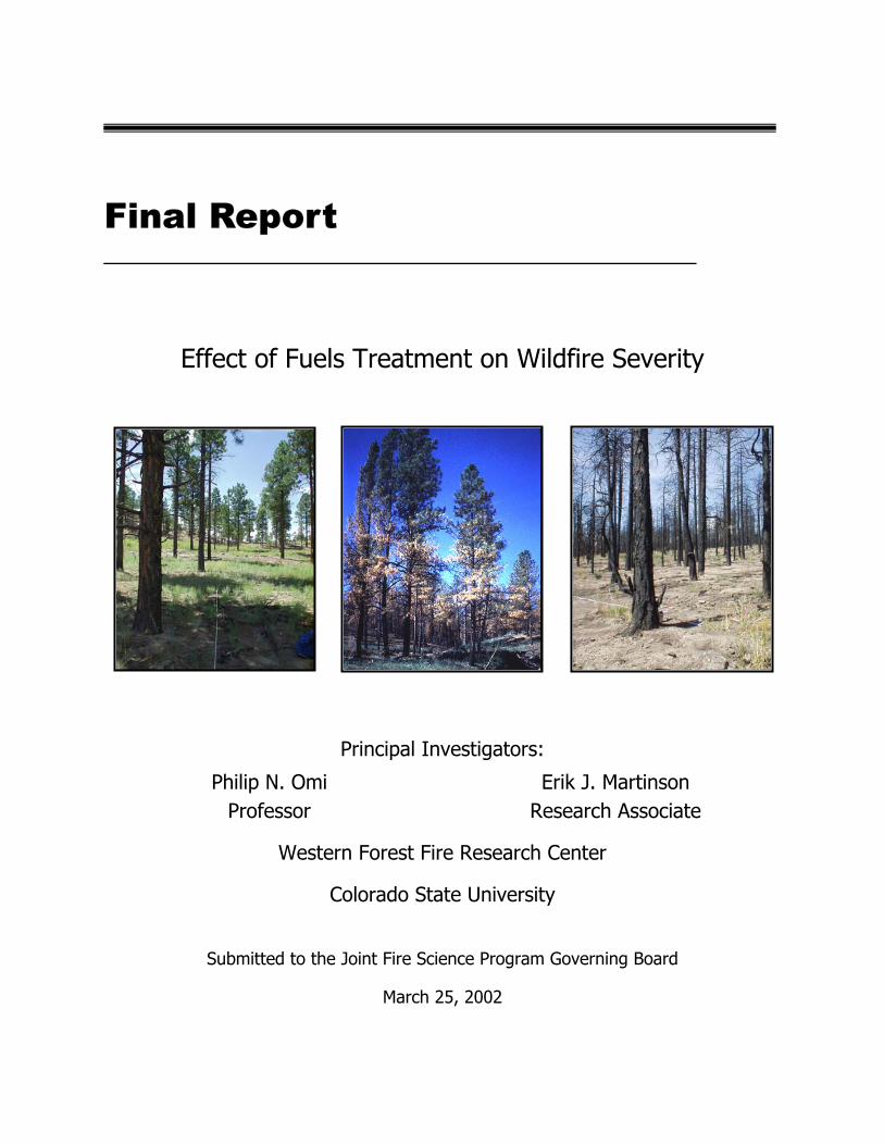
Final Report Effect of Fuels Treatment on Wildfire Severity Principal Investigators: Philip N. Omi Professor Erik J. Martinson Research Associate Western Forest Fire Research Center Colorado State University Submitted to the Joint Fire Science Program Governing Board March 25, 2002
Transcript
Final Report
Effect of Fuels Treatment on Wildfire Severity
Principal Investigators:
Philip N. Omi Professor
Erik J. Martinson Research Associate
Western Forest Fire Research Center
Colorado State University
Submitted to the Joint Fire Science Program Governing Board
March 25, 2002
Executive Summary The severity and extent of wildfires in recent years have increased public awareness of a widespread fuels problem in the nation’s wildlands. Federal land management agencies have responded with plans to greatly expand fuel treatment programs. However, scant information exists on fuel treatment efficacy for reducing wildfire severity.
We investigated the severity of four recent wildfires that burned into existing fuel treatment areas. Treatments included repeated prescribed fires, single prescribed fires, debris removal, and mechanical thinning both with and without slash removal. All treatments were accomplished less than 10 years prior to wildfire occurrence. The historic fire regime of all sampled ecosystems was of the short fire return interval type and included Mississippi slash pine, California Douglas-fir, and ponderosa pine in Colorado and New Mexico. Crown fire hazard (height to crown, crown bulk density, stand density, and basal area), fire resistance (height and diameter), and fire severity (scorch height, crown volume scorch, stand damage, and depth of ground char) were compared between treated and untreated areas. Our results unanimously indicate that treated stands experience lower fire severity than untreated stands that burn under similar weather and topographic conditions. Correlations between fire severity indicators and measures of crown fire hazard and fire resistance were generally good, but individual sites provide unique lessons that illustrate the importance of treating fuel profiles in their entirety. The 20th Century has demonstrated clearly the futility of attempts to eliminate fire from natural landscapes. Society must learn to live with fire and the détente can be realized only through the medium of fuel treatments. Both the small percentage of wildfires that encounter fuel treatments and the small scale of treatments within the wildfires we investigated suggest the enormity of the task at hand.
Acknowledgements We have many people to thank for cooperation and assistance in the completion of this project. Malia Boyum, German Flores, Nikki Omi, and Andrew Beavers of Colorado State University assisted with data collection. Martha Shumann of the Forest Trust also volunteered for a day of data collection. Colorado State University students Todd Gardiner, Craig Goodell, and Esther Schnur helped with data entry. Several land managers greatly facilitated our field visits: Bill Armstrong, Dave Bauman, Rob McClelland, and Lucy Salazaar of the USDA Forest Service, Tony Wilder of the USDI Fish and Wildlife Service, Randy Baker of the USDI Bureau of Indian Affairs, and Jerome Jenkins of the Santa Clara Pueblo. Russell Gripp, Mike Martischang, Darryl Murphy, Al Sandoval, and Diane Strohm of the USDA Forest service and Darrell Holt of the Los Alamos National Laboratory provided weather and spatial information that improved our analyses. This project was made possible by funds from the Joint Fire Science Program. Cover photo. Forest stands burned over by the Cerro Grande fire in the vicinity of Los Alamos, NM. Stands depicted in the left and middle photos were thinned and burned within five years prior to the start of the wildfire. The stand on the right had not been treated.
Contents
Executive Summary……………………………………………………………. i
1. Project Background…………………………………………………………. 1
1.1. Rationale……………………………………………………………………………… 1
1.2. Objectives and Hypotheses………………………………………………………….. 1
1.3. Research Scope………………………………………………………………………. 2
1.4. Previous Work………………………………………………………………………. 3
2. Methods……………………………………………………………………… 5
2.1. Study Site Selection………………………………………………………………….. 5
2.2. Study Areas and Fuel Treatments…………………………………………………. 6
2.2.1. Fountainebleau………………………………………………………………… 6
2.2.2. Megram………………………………………………………………………….. 7
2.2.3. Cerro Grande………………………………………………………………… 8
2.2.4. Hi Meadow……………………………………………………………………… 10
2.3. Data Collection and Analysis………………………………………………………... 12
3. Results……………………………………………………………………….. 16
3.1. Pre-Fire Stand Conditions………………………………………………………….. 16
3.3. Correlations Between Stand Conditions and Wildfire Severity…………………. 20
4. Discussion…………………………………………………………………… 22
5. Conclusions…………………………………………………………………… 25
6. Literature Cited………………………………………………………………. 26
7. Appendix A: Dissemination of Project Results……………………………… 31
8. Appendix B: Description of Sites Considered but Not Sampled……………. 32
9. Appendix C: Model Inputs to Determine Expected Influences of Topographic Dissimilarities on Fire Behavior and Effects………………...
36
List of Tables and Figures Figure 1 Locations of wildfires sampled in this study…………………………………. 6
Table 1 Fontainebleau fire weather conditions ……………………………………….. 7
Figure 2 Fontainebleau study area map………………………………………………... 7
Table 2 Megram fire weather conditions within our study area………………………. 9
Figure 3 Megram study area map………………………………………………………. 9
Table 3 Cerro Grande fire weather conditions within our study area…………………. 10
Figure 4 Cerro Grande study area map………………………………………………… 10
Table 4 Hi Meadow fire weather conditions within our study area…………………… 11
Figure 5 Hi Meadow study area map…………………………………………………... 11
Figure 6 Examples of stand damage rating criteria…………………………………….. 15
Table 5 Pre-fire stand conditions in treated and untreated stands…………………….. 17
Table 6 Pre-fire stand conditions within different types of treatment at the Cerro Grande and Hi Meadow sites……………………………………. 18
Table 7 Influence of topographic dissimilarities at the Megram and Cerro Grande sites……………………………………….. 19
Table 8 Fire severity comparisons between treated and untreated stands…………….. 20
Table 9 Differential effects of treatment type on fire severity at the Cerro Grande and Hi Meadow sites……………………………………. 21
Table 10 Correlations between stand conditions and wildfire severity………………… 21
1. Project Background
1.1. Rationale The severity and extent of wildfires in recent years (e.g., 1988, 1994, 1996, 1999, 2000) have increased public awareness of a widespread fuels problem on many of the nation’s wildlands. However, upward trends in biomass have been evident for several decades (e.g. Cooper, 1960). Fire ecologists generally attribute these fuel accumulations to disrupted disturbance regimes resulting from fire exclusion policies (e.g., the 10am policy of the US Forest Service). Though fuel treatments to reduce fire hazard and restore disturbance regimes have long been advocated (Weaver 1943), implementation has been inconsistent and apparently ineffectual. The General Accounting Office in 1999 charged federal land management agencies to develop a cohesive strategy to address fuel accumulation and the threat of catastrophic wildfires (US General Accounting Office 1999). The US Forest Service responded by recommending at least 5 million acres for immediate (within 3 years) fuels treatment (USDA Forest Service 2000). The US Congress followed with appropriations totaling $796 million in fiscal years 2001 and 2002 for fuel management activities (US General Accounting Office 2002). The unprecedented scale of fuel treatment activities under this new National Fire Plan has intensified debate regarding their means, objectives, and outcomes. For example, the 2001 Musgrove Seminar was devoted to discussion of the National Fire Plan and a scientific conference on fuel treatments will be held in Spring 2002, coordinated by Colorado State University’s Western Forest Fire Research Center and the USDA Forest Service’s Rocky Mountain Research Station. Some interest groups maintain that fuel treatments via mechanical thinning are actually a disguise to expedite timber harvests. Others wonder if potential negative impacts of fuel treatments (e.g. smoke production, exotic invasions, soil damage) outweigh any benefits. Indeed, some question whether fuel treatments even decrease fire potential. Evidence of fuel treatment efficacy for reducing wildfire damages is largely restricted to anecdotal observations and simulations, and easily dismissed by skeptics. The lack of empirical assessment of fuel treatment performance has become conspicuous, but this study continues an ongoing effort to fill the research void.
1.2. Objectives and Hypotheses Our principal goal for this research was to add to a depauperate database on fuel treatment efficacy. We intended to meet 4 objectives and test 2 primary null hypotheses in support of our research goal. Our 4 objectives were as follows: • Compare wildfire severity between areas with different pre-fire fuel treatments and untreated
controls. • Increase the diversity of ecosystems and geographic locations represented in fuel treatment
studies to improve generalizations regarding fuel treatment effectiveness. • Assess the general applicability of forest fire severity sampling methods developed for
ponderosa pine stands. • Develop methods for assessing wildfire severity in non-forested ecosystems.
Our 2 primary null hypotheses were that fuel treatments reduce neither the intensity nor the severity of wildfires. Fireline intensity is a physical parameter related to flame length that describes the rate of heat release from a fire in progress (Byram 1959). Fire severity is a post-fire assessment of effects that incorporates both upward (fireline intensity) and downward (heat-per-unit-area) heat pulses (Rothermel and Deeming 1980). Ground char provides a post hoc indication of heat-per-unit-area, while fireline intensity may be estimated from scorch height in forests (Van Wagner 1973). However, post-fire indicators of intensity are not as clear in other ecosystems. We therefore tested our primary hypotheses with supporting null hypotheses as follows: Ho1: Fuel treatments do not reduce wildfire severity:
H01a: Fuel treatments do not reduce scorch and consumption of green biomass. H01b: Fuel treatments do not reduce ground char depth.
Ho2: Fuel treatments do not reduce wildfire intensity: H02a: Fuel treatments do not reduce scorch height in forested ecosystems. H02b: Fuel treatments do not decrease the minimum diameter of remaining twigs in shrubland ecosystems.
H02c: Fuel treatments do not reduce predicted fireline intensity in grassland ecosystems.
1.3. Research Scope Most studies of fuel treatment effectiveness have been conducted in coniferous forests. We suspect that this is due primarily to a greater prevalence of encounters between wildfires and fuel treatments in these ecosystems. Coniferous forests have historically received priority for fuel treatment resources and this tradition has been continued in the most recent National Fire Plan (Morrison et al. 2001). While we had originally intended to include ecosystems other than coniferous forests in our study on fuel treatment effectiveness, we were able to identify just 1 such potential study site (see Appendix B). Given the disparity among methods that might be used to evaluate the intensity and severity of wildfires in non-coniferous forest ecosystems (i.e., much less energy is required to destroy a grassland, shrubland, or even a deciduous forest than is required to do similar damage in a coniferous forest), we decided our research would be most valuable if the results from all study sites were clearly comparable. Thus, the fourth objective of this project was not met, hypotheses H02b and H02c were not addressed, and our results are applicable only to coniferous forests. There is wide variability in the methods that may be used to assess fuel treatment effectiveness. These methods include a priori assessments in the absence of wildfire occurrence such as fire hazard ratings (Weaver 1957b), fuel inventory (Sackett 1975), or fire behavior predictions (Kalabokidis and Omi 1998); in situ anecdotal observations of fire behavior (Omi 1997: Table 7); post facto remote assessment of fire sizes (Kallander 1969), acres burned (Martin 1988), or fire severity (Weatherspoon and Skinner 1995); and retrospective field measurement of tree mortality (Wagle and Eakle 1979), scorch height (Davis and Cooper 1963), tree crown damage (Omi and Kalabokidis 1991), or soil damage (Pollet and Omi 2002). The assessments of fuel treatment effectiveness described here rely solely on retrospective measurements of scorch height, canopy damage, and depth of ground char.
The objectives and methods of fuel treatment practices also vary widely. A fuel treatment may include any modification of vegetation by any means and the alternatives range from livestock browsing to timber harvest and from mechanical crushing to broadcast burning (see Omi 1997). Historically, fuel treatment objectives focused on removing post-harvest residues (LeBarron 1957, DeByle 1981). More recently, the objectives of fuel treatments often incorporate ecosystem health and restoration (Covington and Moore 1994, Arno et al. 1995). Thus, the definition of a fuel treatment is broad and can be a source of confusion and distrust. We therefore narrowed our definition of a fuel treatment for the purposes of this study to include only non-commercial or pre-commercial activities that involve mechanical thinning (i.e., “low thinning”), debris removal, and/or broadcast burning and that include moderation of wildfire potential as a stated objective.
1.4. Previous Work Very little work has been done that would fit into the scope of our research, i.e. wildfire severity variates measured and compared between untreated areas and non-commercial fuel reduction areas such that an hypothesis regarding treatment efficacy may be statistically tested. However, numerous studies report analyses of fuel treatment effectiveness based on simulation models or estimates of acres burned. Unfortunately, simulation studies are limited by the ability of current models to predict extreme fire behavior (Finney 1998) and acreage burned ignores wildfire behavior and effects. Nonetheless, a spattering of studies have been published since the 1950’s that report reduced wildfire severity in areas that had previously received fuel reduction treatments. Moore et al. (1955) found that a 1951 wildfire in New Jersey killed at least ½ the crown of 64% of sampled trees in untreated areas, while only 17% of trees were similarly damaged in areas that had been prescribe-burned within 3 years and 0% so damaged in areas that had been burned within 1 year. Similarly, Cumming (1964) found that ⅔ of the crown was killed on 79% of sampled pines in untreated areas burned over by a 1963 wildfire in New Jersey, versus 17% of pines so damaged in areas that had been prescribe-burned within the previous 10 years. However, neither of these older studies provides results from formal statistical analyses nor discusses the degree to which fuels were altered by treatment. Somewhat more recently, Van Wagner (1968) found tree survival ranged from 64% to 96% in California coulter pine stands that had been improved (mechanically thinned, pruned, and brush removed) 3 years prior to a wildfire, 86% survival in stands improved 8 years before the wildfire, but less than 15% survival in untreated stands. Wagle and Eakle (1979) observed 1,042 live trees/ha in an Arizona ponderosa pine stand that had been treated with prescribed fire 1 year prior to being burned over by a wildfire, versus just 42 live trees/ha in an adjacent untreated area also burned over by the wildfire. Both of these studies quantify to some extent the amount of surface fuel reduction accomplished by the treatments, but still neither makes any attempt at statistical analysis. Two empirical studies of fuel treatment effects on wildfire severity have been published in the last few years. Oucalt and Wade (1999) found tree mortality in Florida mixed pine to be
significantly lower in stands treated with prescribed burns less than 2 years prior to wildfire than in those that had not been burned for more than 2 years. However, all the stands evaluated in this study had been thinned prior to the wildfire and no untreated controls were available for comparison. Pollet and Omi (2002) evaluated the severity of 4 wildfires that burned over treated areas in ponderosa pine forests in Oregon, Washington, California, and Arizona. Treatments included thinning and burning 1 to 11 years prior to wildfire and in all cases fire severity was found to be significantly lower in treated stands. Only this most recent study included both statistical analysis and comparison of stand conditions in treated and untreated areas such that differential fire effects could be directly related to the intensity of fuels manipulation. The research described in this report is a continuation of the Pollet and Omi (2002) study and follows their methodology of comparing wildfire severity between treated and untreated areas. Thus, our results are directly comparable to theirs. Combined, this is the largest dataset of fuel treatment effects on wildfire severity currently in existence. Nonetheless, the body of knowledge on this subject remains meager and we hope to have opportunities to add to it in the future. Fire severity comparisons between different treatment areas affected by the same wildfire provide a broad indicator of fuel treatment effectiveness for facilitating wildfire control (through incorporation of fireline intensity), as well as mitigating adverse ecological consequences. For example, Chappell and Agee (1996) related fire severity to tree seedling establishment, Noste (1985) and Johnston and Woodward (1985) related fire severity to shrub responses, and DeBano et al. (1996) related fire severity to runoff and sediment production. We believe the few studies mentioned above exhausts the quantitative evidence of non-commercial fuel treatment performances subjected to actual wildfires in the United States. There may be several possible reasons for the existence of this curious research void: • Perhaps the question of fuel treatment effectiveness is uninteresting, e.g.:
The answer may seem obvious and unworthy of scientific inquiry. Fuel treatment activities have perhaps only recently become controversial.
• Adequate assessment of fuel treatment effectiveness may not be possible, e.g.: Records of management activities may be incomplete. Confounding variables such as topography, weather conditions, and stand histories
may be too numerous and uncontrollable. By the time appropriate study sites are identified and arrangements for data collection
are made, the evidence of fuel treatment effects may disappear due to salvage logging, scorched needle cast, or erosion.
Most likely the research void results from a combination of all these factors. Regardless, fuel treatment activities are now quite controversial and scientific evidence of their effectiveness is of immediate interest to land managers, politicians, and interest groups. Management records and the ubiquity of confounding variables do limit the availability of adequate study sites, making their identification and timely data collection a challenge. Nevertheless, our methodology for study site selection and data collection facilitated the successful assessment of fuel treatment effectiveness described in this report.
2. Methods This research investigated the severity of recent wildfires that crossed existing fuel treatment boundaries. Identification and selection of study sites, assessment of forest conditions and fire severity, and data analysis were the major activities associated with this project.
2.1. Study Site Selection Potential study sites were identified through several avenues: • A written request for information was distributed electronically over the Firenet listserve
([email protected]). • Oral appeals for information were made at the California Association for Fire Ecology
Conference in San Diego on November 19, 1999 and at the US Forest Service National Fuels Specialists Meeting in Portland, OR on December 7, 1999.
• Several members of the Joint Fire Science Program’s Governing Board actively sought and provided promising leads.
• The extensive network of Colorado State University graduates currently employed by federal land management agencies also provided leads.
• We remained informed of large wildfire incidents in 1999 and 2000 through regular review of the National Incident Management Situation Report provided online by the National Interagency Fire Center at http://www.nifc.doi.gov/news/sitreprt.html. We initiated contact with fire managers on districts affected by very large wildfires or by smaller fires in areas known to have an active fuels management program.
Upon identification, potential study sites were subjected to the following set of preliminary selection criteria via phone interview with appropriate personnel: • A 1999 or 2000 wildfire included both treated and untreated areas within its perimeter.
Treatments were as defined in Section 1.3 and applied within the last 10 years. Areas were defined as “untreated” if they had received no management action within the last 20 years.
• Stand treatment histories were documented and available. • Major suppression activities that may have impeded fire spread did not take place in
proximity to the potential study sites. • Salvage activities had not taken place and were not scheduled to occur prior to our
availability for a site visit. • Maps of the fire perimeter and stands/treatments were available and could be mailed to us. Appropriate maps and treatment documentation were requested for sites that passed these preliminary criteria. Upon receipt, a second set of criteria were applied through review of the stand treatment maps and histories: • At least 1 burned treatment area was adjacent to and lee (with respect to the direction of fire
spread) of a topographically similar burned but untreated area. • A major road or drainage that may have impeded fire spread did not separate the treated and
• Treatment areas could accommodate multiple plots with a 50m buffer between plots and treatment edges.
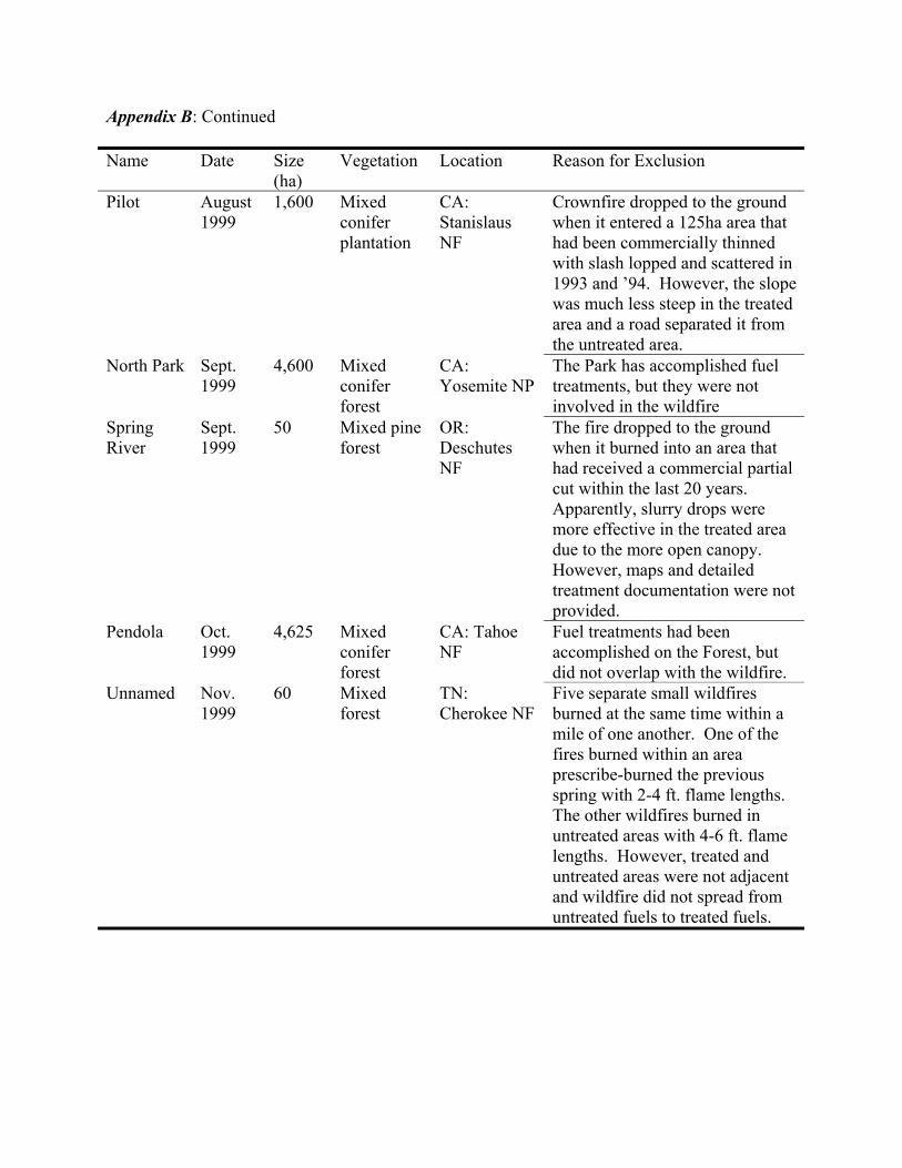
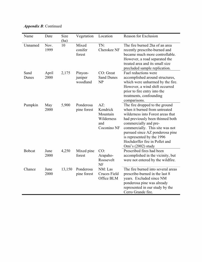
We identified 26 potential study sites, but just 8 of these met our selection criteria and we chose 4 to visit for data collection. Appendix B lists the unvisited potential study sites and the primary reason for their exclusion from data collection.
2.2. Study Areas and Fuel Treatments The 4 wildfires chosen as our study areas for this research were the 1999 Fontainebleau fire in Mississippi, the 1999 Megram fire in California, the 2000 Cerro Grande fire in New Mexico, and the 2000 Hi Meadow fire in Colorado, as shown in Figure 1.
Fontainebleau
Cerro Grande
Hi Meadow
Megram
Figure 1. Locations of wildfires sampled in this study
2.2.1. Fontainebleau The Fontainebleau fire burned on and adjacent to the Fontainebleau Unit of the Mississippi Sandhill Crane National Wildlife Refuge. The Refuge is approximately 8 km east of Ocean Springs in Jackson County, MS in the Gulf Coastal Plain physiographic province. Topography is flat at an elevation of 6 m. Slash pine (Pinus elliottii) is dominant in the forest canopy with longleaf pine (Pinus palustris) also present. Sub-canopy species include persimmon (Diospyros virginiana) and black gum (Nyssa sylvatica). Vines (e.g., Vitis spp. and Smilax spp.), bays (Persea spp.), and gallberry (Ilex coriacea) are abundant in the understory. The US Fish and Wildlife Service established the Refuge in 1975 to protect the endangered Mississippi Sandhill Crane (Grus canadensis pulla) and its wet pine savannah habitat. Management of the Refuge includes extensive use of prescribed fire to reduce hazardous fuels and restore the open structure of longleaf pine savannahs (Platt et al. 1988). One such prescribed fire became the Fontainebleau wildfire at 1430 hours on April 18, 1999 when it spotted across a railroad and onto private property containing untreated fuels best characterized by fuel model 7
(Anderson 1982). The wildfire exhibited extreme behavior and at 1600 hours spotted back across the railroad and into a stand that Refuge managers had burned in 1988, 1992, and 1998 with the objective of converting fuels to approximate model 2 conditions. The Fontainebleau fire grew to a final size of 142 ha including 36.5 ha on Refuge lands last treated in 1998. Hourly weather conditions from an on-site Remote Automated Weather Station are provided in Table 1 and Figure 2 depicts a map of the fire perimeter, treatment area, and plot locations. Data were collected in September 1999. Table 1. Weather conditions during the Fontainebleau Fire on April 18, 1999 (weather data from an onsite Remote Automated Weather Station).
Figure 2. Map of plot locations in relation to fuel treatments involved in the1999 Fontainebleau wildfire on and adjacent to the Mississippi Sandhill Crane National Wildlife Refuge. The fire started as a prescribed burn on the Refuge (in the area shaded light gray), but was declared a wildfire when it spotted across the railroad and onto private property. The wildfire later spotted back across the railroad and into an area the Refuge had previously treated (shaded dark gray).
2.2.2. Megram The Megram fire was ignited by lightning on August 23, 1999 and ultimately became part of the Big Bar Complex that burned until November 11, involving approximately 560 km2 of the Shasta-Trinity and Six Rivers National Forests. The western perimeter of the fire was 6.5 km
northeast of Willow Creek, CA in the Klamath Mountains of the Pacific Border province. The fire made an 8 km run on September 27 and entered a 120 km2 area that had been affected by a blowdown event in the winter of 1995-96. The blowdown increased surface fuel loads by perhaps an order of magnitude (Bonnicksen 2000) and converted the characteristic fuel model from 10 to 13 (Anderson 1982). Surface fuels reduction via yarding and burning started in 1997 and was accomplished in phases in a 2.5 km2 portion of the blowdown area, providing a shaded fuelbreak that draped down the sides of Lonepine Ridge. Additional fuels reduction was in progress at the time of the wildfire incident. The areas included in our study burned between September 27 and October 1, 1999. All sampled treatments were accomplished in the fall of 1997. Topography in the study area is highly complex with many slopes exceeding 35o. Elevation ranges from 1,300 m to 1,500 m. White fir (Abies concolor) and Douglas-fir (Pseudotsuga menziesii) are dominant in the overstory with sugar pine (Pinus lambertina) also present. Sub-canopy species include tanoak (Lithocarpus densiflorus) and Pacific madrone (Arbutus menziesii). Table 2 provides daily weather conditions from the nearest weather station 16 km to the northwest and at 900 m of elevation. Figure 3 depicts a map of the fire severity, fire progression, treatment areas, and plot locations. Data were collected in June 2000.
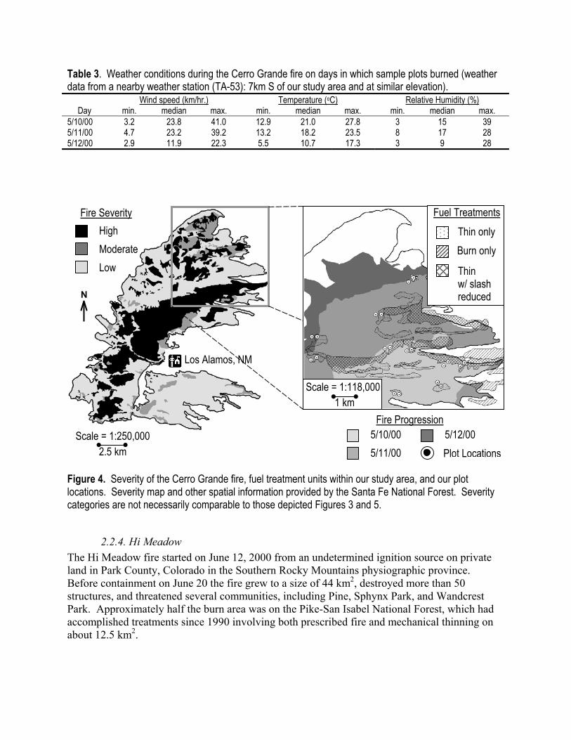
2.2.3. Cerro Grande Like the Fontainebleau fire, the Cerro Grande fire was management ignited. The fire was started on May 4, 2000 in Bandelier National Monument with the objective of reducing fuels and restoring pre-settlement forest structure. The fire went out of prescription on May 5 and high winds on subsequent days prevented control until June 8. The fire reached a final size of 193 km2, destroyed more than 300 structures, and included lands administered by 7 different political entities. These included the Santa Fe National Forest, the Santa Clara Pueblo, and the town of Los Alamos, NM in the Jemez Mountains of the Colorado Plateau. The most active burning days were on May 10 and 11 when the fire burned into the Garcia Canyon watershed where the Forest Service had done extensive treatments since 1994 that included mechanical thinning and prescribed burning, both in isolation and in combination. The fire also burned into an area of the Santa Clara Pueblo where several adjacent 1.8 ha plots had been thinned with slash removed by hand in 1991. Topography in these treatment areas slopes gently eastward, but is frequently interrupted by the steep walls of canyons and mesas. Elevation ranges from 2,100 m to 2,400 m. Ponderosa pine (Pinus ponderosa) is dominant with pinyon pine (Pinus edulis) and juniper (Juniperus spp.) present at lower elevations and white fir present at higher elevations. Sampled treatments that involved thinning without slash removal were accomplished in 1998 and 1999. Thinned areas where slash was reduced on the Forest were cut in 1996, followed by an understory burn in either 1996 or 1998. Table 3 summarizes weather conditions over the period in which sampled areas burned (May 10, 11, 12) from a weather station 7 km to the south and at 2,130 m of elevation. Figure 4 depicts a map of the fire severity, fire progression, treatment areas, and plot locations. Data were collected in August 2000.
Table 2. Weather conditions during the Megram fire on days in which sample plots burned (weather data from the nearest weather station (Big Hill), 500m below and 16km NW of our study area). Wind speed (km/hr) Gust speed (km/hr) Temperature (oC) Relative Humidity (%)
Day min. median max. min. median max. min. median max. min. median max. 9/27/99 4.8 17.7 24.1 11.3 30.6 41.8 9.0 14.3 24.1 14 20 33 9/28/99 12.9 17.7 22.5 17.7 27.4 37.0 11.2 19.6 20.7 17 18 21 9/29/99 1.6 11.3 16.1 4.8 16.1 24.1 15.1 19.6 26.3 16 20 24 9/30/99 0 6.4 9.7 3.2 9.7 17.7 17.4 20.2 27.4 20 27 32
Scale = 1:300,000 3 km
9/29/99 9/30/99
9/27/99 9/28/99
Fire Progression
High Moderate Low
Fire Severity
N
Scale = 1:66,000 1 km
Willow Creek,
CA
Plot Locations Fuel Treatment Units
Figure 3. Severity of the Megram fire on lands administered by the Six Rivers National Forest, daily fire progression and fuel treatment units within our study area, and our plot locations. Severity map and other spatial information provided by the Six Rivers National Forest. Severity categories are not necessarily comparable to those depicted Figures 4 and 5.
Table 3. Weather conditions during the Cerro Grande fire on days in which sample plots burned (weather data from a nearby weather station (TA-53): 7km S of our study area and at similar elevation). Wind speed (km/hr.) Temperature (oC) Relative Humidity (%)
Day min. median max. min. median max. min. median max. 5/10/00 3.2 23.8 41.0 12.9 21.0 27.8 3 15 39 5/11/00 4.7 23.2 39.2 13.2 18.2 23.5 8 17 28 5/12/00 2.9 11.9 22.3 5.5 10.7 17.3 3 9 28
Scale = 1:250,000 2.5 km
5/12/00 Plot Locations
5/10/00 5/11/00
Scale = 1:118,000 1 km
Fire Severity High Moderate Low
Fire Progression
Thin w/ slash reduced
Burn only Thin only
Fuel Treatments
N
Los Alamos, NM
Figure 4. Severity of the Cerro Grande fire, fuel treatment units within our study area, and our plot locations. Severity map and other spatial information provided by the Santa Fe National Forest. Severity categories are not necessarily comparable to those depicted Figures 3 and 5.
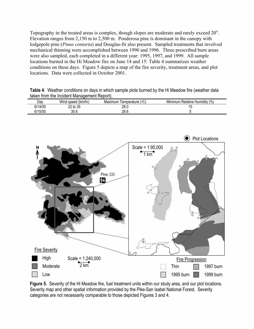
2.2.4. Hi Meadow The Hi Meadow fire started on June 12, 2000 from an undetermined ignition source on private land in Park County, Colorado in the Southern Rocky Mountains physiographic province. Before containment on June 20 the fire grew to a size of 44 km2, destroyed more than 50 structures, and threatened several communities, including Pine, Sphynx Park, and Wandcrest Park. Approximately half the burn area was on the Pike-San Isabel National Forest, which had accomplished treatments since 1990 involving both prescribed fire and mechanical thinning on about 12.5 km2.
Topography in the treated areas is complex, though slopes are moderate and rarely exceed 20o. Elevation ranges from 2,150 m to 2,500 m. Ponderosa pine is dominant in the canopy with lodgepole pine (Pinus contorta) and Douglas-fir also present. Sampled treatments that involved mechanical thinning were accomplished between 1990 and 1996. Three prescribed burn areas were also sampled, each completed in a different year: 1995, 1997, and 1999. All sample locations burned in the Hi Meadow fire on June 14 and 15: Table 4 summarizes weather conditions on these days. Figure 5 depicts a map of the fire severity, treatment areas, and plot locations. Data were collected in October 2001. Table 4. Weather conditions on days in which sample plots burned by the Hi Meadow fire (weather data taken from the Incident Management Report).
Day Wind speed (km/hr) Maximum Temperature (oC) Minimum Relative Humidity (%) 6/14/00 22 to 35 28.0 15 6/15/00 30.6 28.6 5
1997 burn 1999 burn
Thin 1995 burn
Scale = 1:240,000 2 km
Pine, CO
Fire Progression
Fire Severity
N
Plot Locations
High Moderate Low
Scale = 1:95,000 1 km
Figure 5. Severity of the Hi Meadow fire, fuel treatment units within our study area, and our plot locations. Severity map and other spatial information provided by the Pike-San Isabel National Forest. Severity categories are not necessarily comparable to those depicted Figures 3 and 4.
2.3. Data Collection and Analysis Plot locations were determined in advance of field visitation based on maps of wildfire and fuel treatment perimeters provided by land managers. Plots were subjectively placed such that treated and untreated pairs were on similar slope and aspect with no barriers to fire spread between them. Treated and untreated comparison plots were separated by no more than 240 m to minimize differences in weather and site conditions. Edge effects were avoided by insuring a 50 m buffer between plots and treatment perimeters. A final consideration in plot placement was the direction of fire spread; plots were placed such that fire entry into the untreated site would have been prior to, or simultaneous with, entry into the treated site. These precautions in plot placement were critical due to the numerous topographic and climatic factors that may interact with fuels to produce wide variability in fire behavior and effects within large wildfires, as evidenced in Figures 3, 4, and 5. However, to avoid bias in our sampling design, the remotely derived fire severity maps depicted in Figures 3 through 5 were not considered in plot placement, or even acquired until after data collection was completed. Thus, our sampling design insured that any observed differences in wildfire severity between treated and untreated plots could be reasonably attributed to modified fuel conditions, rather than some other confounding influence. Data were collected in variable radius plots defined with a Cruiser’s Crutch at a metric Basal Area Factor 2 at all locations except the Megram fire where larger tree sizes made BAF 6 more appropriate (Avery and Burkhart, 1994). The trees sampled at each plot were distinguished by species and crown position and measured for the following descriptors of stand condition: stand density, basal area, tree size and height, crown position, and height to the base of the pre-fire live crown. The base of the pre-fire live crown was judged to be the lowest branch with twigs, though this may have been an overestimate in severely burned plots if lower live branches or twigs were completely consumed; or an underestimate if lower branches with twigs were needleless prior to the fire. Current theory suggests that crown bulk density is a key descriptor of crown fire hazard (Van Wagner 1977; Rothermel 1991). However, direct measurement of crown bulk density is difficult and requires destructive sampling, which we did not attempt in this study. But we did try to estimate crown bulk density following the method of Agee (1996) and using allometric relationships for crown weight developed by Brown (1978). However, Brown’s relationships were developed for a very limited number of species and from samples collected in the Northern Rocky Mountains. Several species encountered at our study sites are not addressed in Brown (1978), including slash pine, longleaf pine, pinyon pine, sugar pine, and juniper. Crown weights for these species were estimated from relationships for the species included in Brown (1978) that seemed most similar to their growth form. Thus, crown weights for slash pine and longleaf pine were estimated from the allometric relationship for ponderosa pine, those for pinyon pine from lodgepole pine, sugar pine from western white pine, white fir from grand fir, and juniper from western redcedar. Therefore, the crown bulk densities we report should not be taken too literally. Fortunately, improved methods for estimating crown bulk densities is currently an area of active research at the Intermountain Fire Sciences Laboratory. At the Fontainebleau site we also attempted to quantify the pre-fire density and height of shrub fuels (an important component of fuel model 7) by sampling 4 1-m2 circular plots located at 90o angles and 17.85 m from each plot center. No attempt was made to quantify pre-fire conditions
of other surface fuel components at any of the sites post hoc, since the fine fuels that contribute most to surface fire spread are consumed in most fires (Ottmar et al. 1993). We evaluated wildfire severity at each plot in terms of stand damage, as well as upward and downward heat pulse components. Stand damage was rated as follows (see Figure 6, after Omi and Kalabokidis 1991): 0: No damage – all tree crowns unscorched. 1: Spotty damage –partial scorch on at least 1 tree, but some trees unscorched. 2: Moderate damage – partial scorch on all tree crowns, but few trees completely scorched. 3: Heavy damage – nearly all tree crowns completely scorched, but few crowns consumed. 4: Extreme damage – nearly all tree crowns consumed. The downward heat pulse was estimated with ground char ratings in 4 30-cm x 60-cm subplots located at 90o angles and 17.85 m from each plot center. Ground char was rated as follows (after Ryan and Noste 1985): 0: Unburned - no evidence of surface fire. 1: Light - some small twigs or leaves remain. 2: Moderate - all twigs, leaves, and standing grasses consumed, mineral soil charred. 3: Deep - mineral soil altered in color or texture.
The height of needle scorch on the coniferous trees sampled at each plot was measured as an indicator of fireline intensity (Van Wagner, 1973). Percent canopy scorch was ocularly estimated on all trees, as well. Since height of needle scorch underestimates fireline intensity on trees that are either unscorched or completely scorched (i.e., the upper bound of scorch height is limited by tree height, while the lower bound is limited by crown base height), we modified calculations for average scorch height at each plot by excluding measurements from trees that were uninformative or misleading. Specifically, only the following measurements contributed to plot averages for scorch height:
1) Scorch heights of all partially scorched trees. 2) Tree heights of completely scorched trees added sequentially by decreasing height until
average scorch height was maximized. 3) Bole char heights of unscorched trees added sequentially by decreasing height until
average scorch height was maximized. 4) Crown base heights of unscorched trees added sequentially by increasing height until
average scorch height was minimized.
Standard statistical software (SAS Institute 2001) was used to conduct 2-sample 1-tail parametric tests for comparisons of continuous variates between treated and untreated sample plots. Non-parametric Wilcoxon tests were used for ordinal categorical data (i.e., fire severity ratings). Tests for paired data were employed for all sites except Fontainebleau, where plots were unpaired. MetaWin software (Rosenberg et al. 2000) was used to conduct nonparametric randomization (or ‘permutation’) tests for heterogeneity among the effects of the multiple treatment types encountered at the Cerro Grande and Hi Meadow sites. Due to our small within-
treatment sample sizes at these sites, we chose to conduct randomization tests since they may be more powerful than traditional non-parametric tests in such situations. Significance levels for all tests were adjusted by partial Bonferonni correction to account for multiple comparisons (i.e., the Bonferonni adjustment was increasingly liberalized as the correlations among the set of compared variables increased (see ad hoc adjustments to the Bonferonni procedure in Sankoh et al. (1997) or Uitenbroek (2001)).
Figure 6. Examples of stand damage ratings used to evaluate wildfire severity at each sampled plot. 0: No damage – all tree crowns unscorched. 1: Spotty – at least 1 tree partially scorched.
2: Moderate – all trees at least partially scorched.
3: Heavy – all trees completely scorched. 4: Extreme – all tree crowns consumed.
3. Results Analysis of our collected data focused on first determining whether differences existed between treated and untreated stands in topography and pre-fire crown fuel conditions. Where topography was significantly more extreme in untreated areas, we used BEHAVE (Andrews 1986) to estimate the expected effect of the topographic differences on fire behavior and effects. These expected topographic effects were used to adjust our null hypotheses in order to isolate the effect of fuels treatment in statistical tests for fire severity differences between treated and untreated areas. Finally, we assessed the degree of correlation between the variates of pre-fire stand condition and those of fire severity.
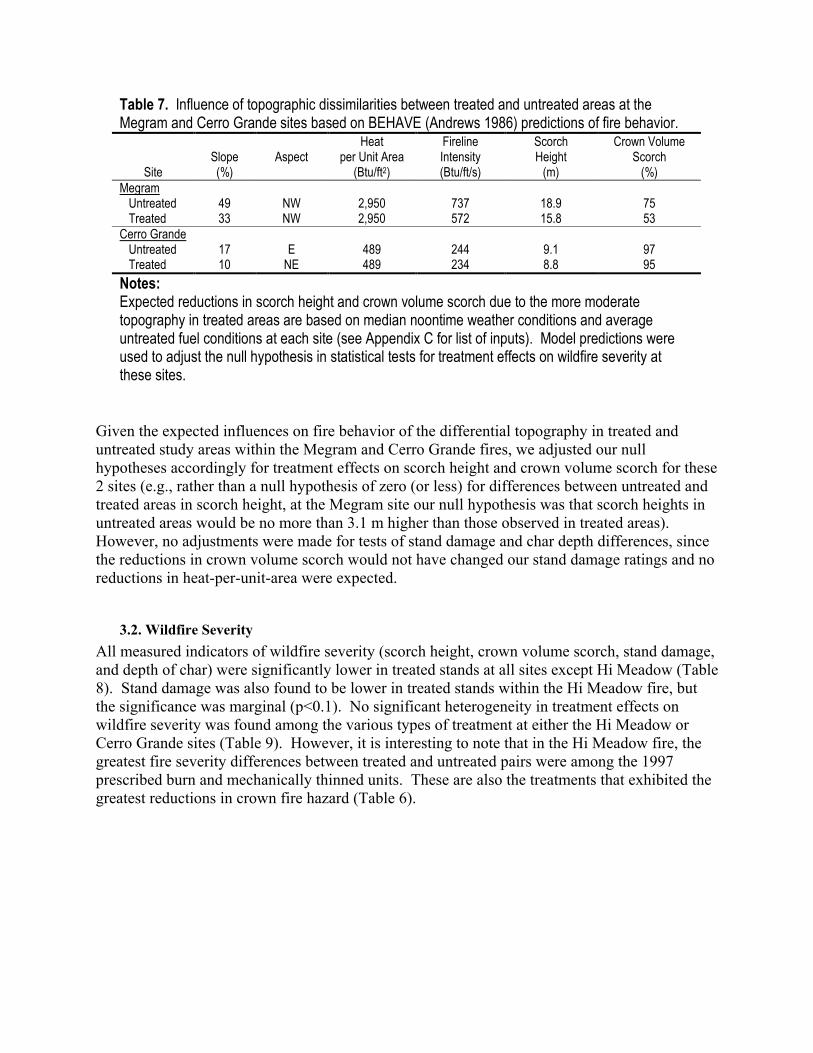
3.1. Pre-Fire Stand Conditions Reconstructed crown fire hazard (particularly crown bulk density and/or height to live crown, though we also considered the more common stand condition descriptors of tree density and basal area as possible contributors to crown fire hazard) was found to be significantly lower in the treated stands at all sites except Hi Meadow (Table 5). Additionally, trees were significantly larger in height and/or diameter, and thus more fire resistant, in treated stands at all sites with the exceptions of two of the treatments within the Hi Meadow fire (the 1995 and1997 prescribed burn units) and the thin-only areas of Cerro Grande. The shrub measurements taken at the Fontainebleau site revealed significantly taller shrubs in the untreated area (p<0.01), but no differences in shrub density. The 2 different treatment types at the Cerro Grande site (thin-only vs. thin with slash treatment) had significantly different effects on height to live crown, with higher crown bases in areas thinned with slash removal than in adjacent untreated areas, but no difference between untreated areas and adjacent areas that were thinned with slash left (Table 6). There was also significant heterogeneity in crown fire hazard among different treatment types at the Hi Meadow site. Surprisingly, stand density appeared substantially greater, and tree diameters smaller, in the oldest (1995) prescribe-burn area than in adjacent untreated areas (though 2-tail tests were not planned a priori and thus not formally conducted). The other treatments in the Hi Meadow fire apparently had no effect on stand density or other indicators of crown fire hazard, though trees were significantly larger in the 1999 prescribed burn unit and the thinned unit than in adjacent untreated areas. Despite our best efforts to minimize topographic differences between treated and untreated plot pairs, some significant differences were found at 2 of the sites. Untreated slopes were significantly steeper at sampled sites within the Megram fire and the Cerro Grande fire (Table 5). Slope aspects of untreated areas also tended to be more southerly at the Cerro Grande site. We expect that average scorch height would have been reduced by 3.1 m and crown volume scorch by 22% in untreated areas of the Megram fire, had slope steepness been similar to that in the treated areas (Table 7). The expected influence of topographic disparities in the Cerro Grande fire is more modest: a 0.3 m difference in scorch height and a 2% difference in crown volume scorch. Appendix C provides the inputs for the fire prediction model used to derive these expectations.
Site
Table 5. Comparison of reconstructed pre-fire stand conditions between treated and untreated areas within the four sampled wildfires (means with standard deviations in parentheses). Differences tested for statistical significance with paired t-tests (except Fontainebleau where plots were not paired). Significance levels adjusted for multiple comparisons by partial Bonferroni correction. Stand
Density1 (Trees/ha)
Basal Area1
(m2/ha)
Crown Bulk Density2 (kg/ha)
Height to Live
Crown2 (m)
Tree Diameter1
(cm)
Tree Height2
(m)
Slope (%)
Aspect
(0-180o) Fontainebleu
Untreated (n=9)
2,496 (2,092)
19.1 (10.8)
0.11 (0.09)
7.3 (2.7)
10.7 (4.7)
10.6 (4.2)
0 NA
Rx burn x3 (n=9)
373 b
(224) 14.2 (7.8)
0.04 b (0.01)
11.1 c (2.2)
20.9 e (3.4)
16.5 c (2.5)
0 NA
Megram Untreated
(n=11) 583
(538) 52.9
(23.2) 0.12
(0.07) 11.3 (5.6)
39.6 (18.5)
26.7 (11.1)
49.6 (19.5)
78.7 (46.2)
Debris redux (n=11)
184 b (82)
51.3 (16.0)
0.10 (0.04)
14.5 (3.9)
57.7 c (12.6)
32.5 (5.0)
33.3 a (13.7)
81.6 (65.5)
Cerro Grande Untreated
(n=10) 608
(334) 19.4 (7.3)
0.13 (0.06)
3.2 (2.2)
20.5 (6.3)
10.8 (3.9)
17.0 (7.3)
83.5 (43.6)
Treated (n=10)
298 a (254)
9.8 b (4.5)
0.06 b (0.04)
3.6 (1.9)
25.7 (11.4)
12.2 (5.2)
10.2 b (6.4)
46.3 b (40.2)
Hi Meadow Untreated
(n=12) 539
(234) 20.3 (5.7)
0.12 (0.02)
2.5 (1.0)
21.6 (6.3)
10.6 (2.5)
19.4 (11.1)
41.7 (28.3)
Treated (n=12)
585 (495)
17.2 (7.0)
0.10 (0.04)
2.8 (1.7)
22.0 (7.4)
11.0 (3.3)
23.5 (15.3)
48.3 (32.6)
Notes: 1 Includes all trees sampled. 2 Includes only coniferous trees. An emboldened value indicates a significant difference between the treated mean and corresponding untreated mean in the hypothesized direction at the significance level indicated by the superscript: a p<0.1. b p<0.05. c p<0.01. d p<0.001. e p<0.0001.
Table 6. Comparisons of pre-fire stand conditions among multiple treatment types at the Cerro Grande and Hi Meadow sites. Mean differences (untreated – treated) are shown with parentheses containing bootstrapped 95% Confidence Intervals corrected for bias and multiple comparisons. Due to small sample sizes, differences between treatment types were tested for significance non-parametrically by randomized permutation.
Site
Stand Density1
(Trees/ha)
Basal Area1
(m2/ha)
Crown Bulk Density2 (kg/ha)
Height to Crown2
(m)
Tree Diameter1
(cm))
Tree Height2
(m)
Slope (%)
Aspect
(0-180o) Cerro Grande
Thin (n=5)
220 (-308–708)
8.8 (1.6–16.0)
0.05 (-0.05–0.15)
1.2 (-0.2–2.7)
2.2 (-6.2–11.3)
2.5 (-1.0–7.2)
6 (1.6–11.2)
33.2 (1.6–83.6)
Thin / slash redux (n=5)
400 (278–555)
10.4 (4.4–24.8)
0.09 (0.06–0.13)
-2.0 c (-5.0– -0.5)
-12.7 c (-18.1– -4.8)
-5.4 c (-9.7– -2.1)
7.6 (-0.8–16.2)
41.2 (9.4–73.2)
Hi Meadow
Rx Burn 1995 (n=3)
-703 * (-1173– -433)
0.7 (-8.0–8.0)
-0.04 (-0.07–0.02)
0.1 (-2.6–1.8)
11.0 * (8.0–13.3)
2.8 (0.3–4.2)
-11.3 (-25.0– -2.7)
28.3 (-1.0–62.0)
Rx Burn
1997 (n=3) 136
(-130–455) 6.7
(-8.0–22) 0.04
(0.0–0.11) -1.1
(-4.4–1.2) -5.4
(-13.6–1.3) -2.4
(-4.9–2.0) -3.0
(-11.0–2.0) 5.0
(-14.0–22.0)
Rx Burn 1999 (n=3)
15 (-271–256)
-4.0 (-12–4.0)
0.00 (-0.01–0.01)
-0.3 (-1.6–0.4)
-4.1 c (-7.4– -0.6)
-2.6 (-5.3–0.1)
-6.3 (-26.0–4.0)
11.0 (7.0–16.0)
Thin (n=3)
368 (-34–738)
9.3 (-8.0–22)
0.06 (0.02–0.11)
0.2 (-2.6–1.9)
-2.8 c (-4.0– -1.6)
0.6 (-4.0–3.3)
4.3 (-11.0–18.0)
-17.7 (-37.0–0.0)
Notes: Columns with emboldened cells indicate significant (p<0.1) heterogeneity among treatment types in the differences between treated and untreated pairs for the specified variable. Where no significant heterogeneity is indicated, refer to Table 5 for results of the combined test of overall treatment effect. Alphabetic superscripts indicate the level of significance (see Table 5) of any differences between treated and untreated pairs within the specified treatment type (tested only in the presence of significant between-treatment type heterogeneity). See Table 5 for explanation of numeric superscripts. * Indicates that a significant difference would have been found between treated and untreated pairs within
the specified treatment type with an a priori two-tailed test (i.e., the direction of the difference is contrary to expectation).
Table 7. Influence of topographic dissimilarities between treated and untreated areas at the Megram and Cerro Grande sites based on BEHAVE (Andrews 1986) predictions of fire behavior.
Site
Slope (%)
Aspect
Heat per Unit Area
(Btu/ft2)
Fireline Intensity (Btu/ft/s)
Scorch Height
(m)
Crown Volume Scorch
(%) Megram Untreated 49 NW 2,950 737 18.9 75 Treated 33 NW 2,950 572 15.8 53 Cerro Grande Untreated 17 E 489 244 9.1 97 Treated 10 NE 489 234 8.8 95 Notes: Expected reductions in scorch height and crown volume scorch due to the more moderate topography in treated areas are based on median noontime weather conditions and average untreated fuel conditions at each site (see Appendix C for list of inputs). Model predictions were used to adjust the null hypothesis in statistical tests for treatment effects on wildfire severity at these sites.
Given the expected influences on fire behavior of the differential topography in treated and untreated study areas within the Megram and Cerro Grande fires, we adjusted our null hypotheses accordingly for treatment effects on scorch height and crown volume scorch for these 2 sites (e.g., rather than a null hypothesis of zero (or less) for differences between untreated and treated areas in scorch height, at the Megram site our null hypothesis was that scorch heights in untreated areas would be no more than 3.1 m higher than those observed in treated areas). However, no adjustments were made for tests of stand damage and char depth differences, since the reductions in crown volume scorch would not have changed our stand damage ratings and no reductions in heat-per-unit-area were expected.
3.2. Wildfire Severity All measured indicators of wildfire severity (scorch height, crown volume scorch, stand damage, and depth of char) were significantly lower in treated stands at all sites except Hi Meadow (Table 8). Stand damage was also found to be lower in treated stands within the Hi Meadow fire, but the significance was marginal (p<0.1). No significant heterogeneity in treatment effects on wildfire severity was found among the various types of treatment at either the Hi Meadow or Cerro Grande sites (Table 9). However, it is interesting to note that in the Hi Meadow fire, the greatest fire severity differences between treated and untreated pairs were among the 1997 prescribed burn and mechanically thinned units. These are also the treatments that exhibited the greatest reductions in crown fire hazard (Table 6).
Table 8. Comparison of fire severity indicators between treated and untreated stands within the four sampled wildfires (means with standard deviations in parentheses). Differences tested for statistical significance with t-tests (scorch height) or non-parametric Wilcoxon Rank tests as appropriate. Significance levels adjusted for multiple comparisons by partial Bonferroni correction.
Site Scorch Height (m)
Crown Volume Scorch (%)
Stand Damage Rating (0-4)
Depth of Char Rating (0-3)
Fontainebleu Untreated
(n=9) 15.4 (5.0)
99.5 (1.0)
3.1 (0.8)
1.2 (0.2)
Rx burn x3 (n=9)
10.0 b (2.9)
13.9 e (21.7)
0.8 e
(0.7) 1.0 b (0.0)
Megram Untreated
(n=11) 31.4
(17.4) 71.6
(40.0) 1.9
(1.2) 1.6
(0.7) Debris redux
(n=11) 14.0 b (8.1)
16.9 b (27.4)
0.5 c (0.7)
0.7 c (0.4)
Cerro Grande Untreated
(n=10) 15.3 (5.1)
96.0 (7.8)
3.1 (0.7)
1.5 (0.7)
Treated (n=10)
10.6 a (4.9)
61.9 c (34.3)
2.1 b (1.0)
1.0 b (0.4)
Hi Meadow Untreated
(n=12) 10.5 (6.1)
65.3 (39.7)
2.3 (1.3)
1.5 (0.7)
Treated (n=12)
8.8 (5.7)
56.3 (38.7)
1.9 a (1.0)
1.2 (0.5)
Notes: Emboldened cells indicate significantly lower severity in the treated area and superscripts indicate the level of significance (see Table 5).
3.3. Correlations Between Stand Conditions and Wildfire Severity There are significant correlations between many of the stand condition variates and fire severity variates across all study sites (Table 10). Among the indicators of crown fire hazard the strongest correlation was a negative one between height to live crown and stand damage. Stand damage was the fire severity measure also most strongly correlated with indicators of fire resistance: tree height and diameter. Among topographic variables, the only significant correlation was positive between slope and scorch height. Not too surprisingly, depth of char was not significantly correlated to any of the stand condition variables we were able to measure. However, when viewed individually, the Megram site did exhibit strong positive correlations between char depth and both stand density (r=0.55, p<0.1) and slope (r=0.60, p<0.05). Also, across all study sites char depth had significant positive correlations with the other fire severity measures of stand damage (r=0.55, p<0.001), crown volume scorch (r=0.55, p<0.001), and scorch height (r=0.48, p<0.001). Somewhat surprising are the positive correlations between scorch height and basal area, height to live crown, and tree height, especially since the other fire severity indicators are negatively correlated to these variables. However, this result is an artifact of the ability of larger trees to record higher scorch. For example, the site with the largest trees (Megram) had the highest
scorch heights, but the lowest stand damage ratings and crown volume scorch percentages. Thus, the most useful measure of fire severity varies across ecosystems.
Table 9. Fire severity comparisons among multiple treatment types at the Cerro Grande and Hi Meadow sites. Mean differences (untreated – treated) are shown with parentheses containing bootstrapped 95% Confidence Intervals corrected for bias and multiple comparisons. Due to small sample sizes, differences between treatment types were tested for significance non-parametrically by randomized permutation.
Site Scorch Height (m)
Crown Volume Scorch (%)
Stand Damage Rating (0-4)
Depth of Char Rating (0-3)
Cerro Grande Thin (n=5)
4.7 (-2.7–12.1)
21.9 (-2.1 – 56.1)
1.0 (0.2–1.8)
0.6 (-0.4–1.4)
Thin / slash redux (n=5)
4.1 (0.1–9.6)
42.4 (29.5–55.7)
1.0 (0.4–1.6)
0.4 (-0.1–1.0)
Hi Meadow Rx Burn 1995
(n=3) 2.4
(-3.2–5.7) -6.3
(-48.0–16.2) 0.3
(-0.5–0.8) 0.5
(0.0–1.1) Rx Burn 1997
(n=3) 2.6
(0.8–6.4) 24.2
(7.7 – 49.3) 0.7
(0.5–0.8) -0.2
(-0.7 – 0.9) Rx Burn 1999
(n=3) -0.8
(-2.4–2.4) 2.2
(-34.9–29.0) -0.2
(-1.5 – 1.0) 0.1
(-1.0 – 1.3) Thin (n=3)
2.5 (-2.1–9.9)
16.1 (-0.5–32.0)
0.8 (0.2–2.0)
0.8 (0.4–1.4)
Notes: Emboldened cells indicate significant (p<0.1) heterogeneity among treatment types in the differences between treated and untreated pairs for the specified variable. Since no significant heterogeneity is indicated, refer to Table 5 for results of the combined tests of overall treatment effects.
Table 10. Correlations between stand conditions and wildfire severity across all study sites.
Crown Fire Hazard Fire Resistance Topography
Fire Severity Stand
Density Basal Area
Crown Bulk Density
Height to Crown
Tree Diameter
Tree Height
Slope
Aspect
Scorch Ht. -0.03
0.37 c 0.11 0.28 a 0.23 0.32 b 0.39 c 0.19
CVS1
0.33 b -0.15 0.30 b -0.44 d -0.42 d -0.44 d -0.16 0.00
Damage
0.33 b -0.33 b 0.23 -0.51 d -0.50 d -0.51 d -0.19 -0.01
Char
0.06 -0.04 0.15 -0.19 -0.23 -0.17 0.14 0.03
Notes: Emboldened correlations are different from zero at the significance level indicated by the superscript (see Table 5). Significance levels adjusted for multiple comparisons by partial Bonferroni correction. 1 Crown volume scorch.
Discussion Taken together, the results from the 4 sites sampled in this research provide strong evidence of fuel treatment efficacy: a controversial tenet of wildfire management that enjoys little empirical support. Such support is critical for planned expansions of prescribed fire and mechanical treatment programs as they come under increased criticism and scrutiny from a public averse to the smoke impacts and escape risks associated with prescribed fire, and distrustful of any proposal that involves tree removal. Generally, our results are very much in agreement with the few comparable studies that were previously published. The reduction in crown volume scorch in treated areas averaged 46% among our study sites (range = 9% to 86%). This is quite similar to the average (47%) and range (26% to 70%) of reductions measured by Pollet and Omi (2002), the 47% scorch reduction observed by Moore et al. (1955), the 62% reduction reported by Cumming (1964), and roughly comparable to the 49% mortality reduction reported by Van Wagner (1968). Our range of reductions in damage ratings for treated stands (0.4 to 2.3) is also very similar to the range of 0.6 to 1.6 observed by Pollet and Omi (2002), who used comparable criteria. Agee (1996) has suggested a crown bulk density threshold of 0.1 kg/ha as a general determinant for active crowning under extreme fire conditions. It is notable that all of our treated areas averaged at or below this threshold, while all untreated areas averaged above. A stand damage rating of 4 is a fair indicator of active crown fire in our methodology: among the 84 plots we sampled, a 4 was assigned to just 1 treated plot whereas 10 untreated plots received such a rating. However, crown bulk density was not the fuel hazard variable most strongly correlated to fire severity at our study sites; in fact it was significantly correlated only to crown volume scorch. Instead, height to live crown, the variable that determines crown fire initiation rather than propagation (Van Wagner 1977), had the strongest correlation to fire severity in the areas we sampled. Like Pollet and Omi (2002), we also found the more common stand descriptors of stand density and basal area to be important factors. But especially crucial are variables that determine tree resistance to fire damage, such as diameter and height. Thus, “fuel treatments” that reduce basal area or density from above (i.e., removal of the largest stems) will be ineffective within the context of wildfire management. Our Hi Meadow site was exceptional in that stand condition variables were poorly correlated to fire severity and here we found no significant reductions in crown fuel hazard within the treated areas. Nonetheless, stand damage was significantly reduced within fuel treated areas. Presumably, the treatments sufficiently modified surface fuels to reduce wildfire intensity and mitigate damages, but we were not able to assess pre-fire surface fuel conditions. Fire severity was quite moderate in most of the untreated areas we sampled at the Hi Meadow site. Under such non-extreme wildfire conditions, we would expect crown fuels to be a less important determinant of fire effects. Interestingly, one of the wildfires sampled by Pollet and Omi (2002) also included areas where the only recent treatment was a single prescribed fire. They also found fire severity reductions in this treated area that could not be correlated to differences in stand conditions.
In contrast, results from the Cerro Grande fire suggest that under extremely windy conditions it may be surface fuels that are of little importance. We had expected to find the thinning treatments with no slash removal to be less effective than the treatments where slash was burned or removed. In fact, based on the results of both Vihanek and Ottmar (1993) and Weatherspoon and Skinner (1995), we would not have been surprised to find fire severity exacerbated by the addition of activity fuels to the surface complex. But instead we found the thinning treatments equally effective, regardless of whether the resulting slash had been subsequently treated. Taken together, the Cerro Grande and Hi Meadow sites demonstrate the importance of treating fuel profiles in their entirety. Though our results appear quite similar to those reported by previous authors, we believe this study adds substantial weight to the evidence in support of fuel treatments. All previous studies were unable to avoid pseudo-replication (Hurlbert 1984) in that samples were collected from a single homogenous area that burned under fairly constant weather conditions. The first site we sampled, Fontainebleau, followed a similar design. Perhaps consequently, this is where our statistical tests tended to be the most significant. However, this site offered no alternative sample design. The other wildfires we sampled burned over multiple treatments with some spatial dispersion that subjected them to more variable wildfire behavior. The treatments at these sites were also implemented at different times and were thus more variable in their effects on the subject fuel profiles. While our tests for fuel and fire severity differences were somewhat less significant as a result, they may be generalized with greater confidence. Two other caveats regarding the Fontainebleau site bear mention. First is the railroad track separating the treated and untreated areas we sampled. While this is a substantial fuel break, it failed to stop fire spread; not once but twice. Further, this fire was not even curtailed by a much wider divided highway that included a mown median. We therefore believe that the reduction in fire severity that the treatments accomplished is undiminished by the presence of the railroad and we decided not to exclude the Fontainebleau fire from our study. The second caveat for the Fontainebleau site is the unknown management history of the privately owned stand that served as our untreated control. While no activity has occurred in this stand since establishment of the Wildlife Refuge in 1975, its condition differed from the treated stand to such a degree that we find it difficult to believe 3 prescribed fires alone accomplished the difference. Rather, the untreated stand had probably been clearcut sometime in the past with no subsequent management (personal communication from Tony Wilder, Refuge Fire Management Officer). Nonetheless, the Fontainebleau site illustrates the differential consequences of fuels management and lack thereof when a wildfire occurs. The Megram site also had minor fuel breaks in the form of unpaved roads that separated some of our treated-untreated plot pairs. These were not on the maps we used to locate our plots prior to field visitation. It was not possible to avoid the roads and retain a sufficient sample size, but because of their narrow width and their failure to impede fire spread, we determined that there was insufficient cause to exclude these plots from our evidence.
The evidence from the 4 wildfires we sampled demonstrates the effectiveness of fuel reduction treatments in disparate locations and forest types. However, all 4 sites have in common a historic fire regime that was characterized by relatively frequent and low severity fires (Brown et al. 1999; Platt et al. 1988; Taylor and Skinner 1998; Touchan et al. 1996). The disturbance regime of these ecosystems has been substantially altered by 20th Century land use and management practices such that accumulated fuels now promote more disastrous wildfire occurrences (Martinson and Omi In Press). Judicious fuels management can mitigate wildfire effects in ecosystems such as those included in our study. However, fuels treatment may be less effective in ecosystems where fires were historically less frequent, but of high severity when they did occur. Alexander et al. (In Press), for example, suggest that fire intensity may be exacerbated by fuel treatments in boreal forests of the Canadian Northwest Territories, where fire severity was and remains characteristically high and 20th Century fire exclusion has affected relatively little change in fire frequency (Larsen 1997). Thus, while fuels treatments can effectively reduce wildfire damages, as demonstrated by the results of this study, the characteristics of the ecosystems in which they are placed merits careful consideration.
4. Conclusions Theoretically, fuel treatments have the potential to exacerbate fire behavior. Crown fuel reduction exposes surface fuels to increased solar radiation, which would be expected to lower fuel moisture content and promote production of fine herbaceous fuels. Surface fuels may also be exposed to intensified wind fields, accelerating both desiccation and heat transfer. Treatments that include prescribed burning will increase nutrient availability and further stimulate production of fuels with high surface-area-to-volume ratios. All these factors facilitate the combustion process, increase rates of heat release, and intensify surface fire behavior. Fuel treatments may therefore seem nonsensical and ill-advised to some, especially when objectives include conversion of a fuel model 7, 8, or 9 to fuel model 2 (Anderson 1982): a condition predicted to be more hazardous by fire behavior models that ignore crown fire potential. But crown fire potential cannot be ignored. While surface fire intensity is a critical factor in crown fire initiation, height to crown: the vertical continuity between fuel strata, is equally important. Further, crown fire propagation is dependent on the abundance and horizontal continuity of canopy fuels. Thus, treatments that reduce canopy fuels increase and decrease fire hazard simultaneously. With little empirical evidence and an infant crown fire theory, fuel treatment practitioners have gambled that a reduction in crown fuels outweighs any increase in surface fire hazard. Our research demonstrates that their bets have been well placed. Fuel treatments moderate extreme fire behavior within treated areas, at least in short fire return interval systems. Still unanswered are questions regarding necessary treatment intensities and duration of treatment effects. Synthesis of our data with those of Pollet and Omi (2002) may begin to answer these questions, but more information is clearly needed. However, the greatest contributions of fuel treatments may be the options they provide for landscape management that balances societal preferences with the unavoidable recurrence of wildland fires. Where fire threatens societal values, fuel treatments can facilitate suppression by providing safe access and egress for firefighters, as well as possible counter-firing opportunities. In wildlands managed to include natural processes, fuel treatments may help restore fire to its historic regime, either by restoring fuel profiles that facilitate safe management ignitions or by buffering the border between values-at-risk and extensively managed areas where natural ignitions are allowed to play themselves out. The 20th Century has demonstrated clearly the futility of attempts to eliminate fire from natural landscapes. Society must learn to live with fire and the détente can be realized only through the medium of fuel treatments. Both the small percentage of wildfires that encounter fuel treatments (Appendix B) and the small scale of treatments within the wildfires we investigated (Figures 3 and 4) serve to illustrate the enormity of the task at hand.
5. Literature Cited Agee, JK. 1996. The influence of forest structure on fire behavior. Pages 52-68 in Sherlock, J. (chair). Proceedings of the 17th annual forest and vegetation management conference. The Conference, Redding, CA. Alexander, M, C Stefner, J Beck, and R Lanoville. In Press. New insights into the effectiveness of fuel reduction treatments on crown fire potential at the stand level. In bushfire 2001 conference proceedings. Forest Research, Christchurch, New Zealand. Anderson, HE. 1982. Aids to determining fuel models for estimating fire behavior. USDA Forest Service General Technical Report INT-GTR-122. Andrews, PL. 1986. BEHAVE: fire prediction and fuel modeling system: BURN subsystem, part 1. USDA Forest Service General Technical Report INT-GTR-194. Arno, SF, MG Harrington, CE Fiedler, and CE Carlson. 1995. Restoring fire-dependent ponderosa pine forests in western Montana. Restoration and Management Notes 13:32-36. Avery, TE and HE Burkhart. 1994. Forest measurements, 4th edition. McGraw-Hill Book Co., New York. Bonnicksen, TM. 2000. A plan to restore areas affected by the Megram fire: Six Rivers National Forest. Evergreen Magazine Winter 2000. Brown, JK. 1978. Weight and density of crowns of Rocky Mountain conifers. USDA Forest Service Research Paper INT-RP-197. Brown, PM; MR Kaufmann, and WD Shepperd. 1999. Long-term landscape patterns of past fire events in a montane ponderosa pine forest of central Colorado. Landscape Ecology 14:513-532. Byram, GM. 1959. Combustion of forest fuels. Pages 61-123 in Davis, KP (editor). Forest fire control and use. McGraw-Hill, New York. Chappell, CB and JK Agee. 1996. Fire severity and tree seedling establishment in Abies magnifica forests, southern Cascades, Oregon. Ecological Applications 6:628-640. Cooper, CF. 1960. Changes in vegetation, structure, and growth of southwestern pine forest since white settlement. Ecological Monographs 30:129-164. Covington, WW and MM Moore. 1994. Post-settlement changes in natural fire regimes and forest structure: ecological restoration of old-growth ponderosa pine forests. Journal of Sustainable Forestry 2:153-181.
Cumming, JA. 1964. Effectiveness of prescribed burning in reducing wildfire damage during periods of abnormally high fire danger. Journal of Forestry 62:535-537. Davis, LS and RW Cooper. How prescribed burning affects wildfire occurrence. Journal of Forestry 61:915-917. DeBano, LF, PF Ffolliott, and MB Baker, Jr. 1996. Fire severity effects on water resources. In Ffolliott, PF, LF DeBano, MB Baker,, Jr., GJ Gottfried, G. Solis-Garza, CB Edminster, DG Neary, LS Allen, and RH Hamre (Coordinators). Fire effects on Mandrean Province ecosystems: a symposium proceedings. USDA Forest Service General Technical Report RM-GTR-289:77-84. DeByle, NV. 1981. Clearcutting and fire in the larch/Douglas-fir forests of western Montana - a multifaceted research summary. USDA Forest Service General Technical Report INT-GTR- 99. Finney, MA. 1998. FARSITE: Fire area simulator – Model development and evaluation. USDA Forest Service Research Paper RMRS-RP-4:1-47. Hurlbert, S.H. 1984. Pseudoreplication and the design of ecological field experiments. Ecological Monographs 54: 187-211. Johnston, M and P Woodward. 1985. The effect of fire severity level on post-fire recovery of hazel and raspberry in east-central Alberta. Canadian Journal of Botany 63:672-677. Kalabokidis, KD and PN Omi. 1998. Reduction of fire hazard through thinning/residue disposal in the urban interface. International Journal of Wildland Fire 8:29-35. Kallander, HR. 1969. Controlled burning on the Fort Apache Indian Reservation, Arizona. Tall Timbers Fire Ecology Conference Proceedings 9:241-249. Larsen, CPS. 1997. Spatial and temporal variations in boreal forest fire frequency in northern Alberta. Journal of Biogeography 24:663-673. LeBarron, RK. 1957. Silvicultural possibilities of fire in northeastern Washington. Journal of Forestry 55:627-630. Martin, GG. 1988. Fuels treatment assessment--1985 fire season in Region 8. Fire Management Notes 49(4):21-24. Martinson, EJ and PN Omi. In Press. Relating pre-settlement fire regimes to 20th Century fire potential may augment ecological justifications for fuel treatment programs. In DeGroot, WJ and RT Engstrom (co-chairs) Tall Timbers 22nd Fire Ecology Conference: Fire in Temperate, Boreal and Montane Ecosystems. Tall Timbers Research Station, Tallahassee, FL. Moore, EB, GE Smith, and S Little. 1955. Wildfire damage reduced on prescribe-burned areas in New Jersey. Journal of Forestry 53:339-341.
Morrison, PH, KJ Harma, JW Karl, L Swope, RK Allen, I Standen, and A Workowski. 2001. Initial assessment: year 2001 wildfire situation in the Western US. Pacific Biodiversity Institute, Winthrop, WA. Noste, NV. 1985. Influence of fire severity on response of evergreen ceanothus. In Lotan, JE and JK Brown (compilers). Symposium on fire’s effects on wildlife habitat. USDA Forest Service General Technical Report INT-GTR-186:91-96. Omi, PN. 1997. Fuels modification to reduce large fire probability: final report. Colorado State University, Fort Collins, CO. Omi, PN and KD Kalabokidis. 1991. Fire damage on extensively versus intensively managed forest stands within the North Fork Fire, 1988. Northwest Science 65:149-157. Ottmar, RD, MF Burns, JN Hall, and AD Hanson. 1993. CONSUME user’s guide. USDA Forest Service General Technical Report PNW-GTR-304. Oucalt, KW and DD Wade. 1999. The value of fuel management in reducing wildfire damage. In Neuenschwander, LF and KC Ryan (editors). Proceedings of the conference on crossing the millennium: integrating spatial technologies and ecological principals for a new age in fire management. University of Idaho, Moscow. Platt, WJ, GW Evans, and SL Rathburn. 1988. The population dynamics of a long-lived conifer (Pinus palustris). The American Naturalist 131:491-525. Pollet, J and PN Omi. 2002. Effect of thinning and prescribed burning on wildfire severity in ponderosa pine forests. International Journal of Wildland Fire 11: in press. Rosenberg, MS, DC Adams, and J Gurevitch. 2000. MetaWin 2.0: statistical software for meta-analysis. Sinaur Associates, Sunderland, MA. Rothermel, RC. 1983. How to predict the spread and intensity of forest and range fires. USDA Forest Service General Technical Report INT-GTR-143. Rothermel, RC. 1991. Predicting behavior and size of crown fires in the northern Rocky Mountains. USDA Forest Service Research Paper INT-RP-438. Rothermel, RC and JE Deeming. 1980. Measuring and interpreting fire behavior for correlation with fire effects. USDA Forest Service General Technical Report INT-GTR-93. Ryan, KC and NV Noste. 1985. Evaluating prescribed fires. Pages 230-238 in Lotan, JE (editor). Proceedings of the symposium and workshop on wilderness fire. USDA Forest Service General Technical Report INT-GTR-182.
Sankoh, AJ, MF Huque, and SD Dubey. 1997. Some comments on frequently used multiple endpoint adjustment methods in clinical trials. Statistics in Medicine 16:2529-2542. SAS Institute, Inc. 2001. The SAS system for windows, release 8.2. The SAS Institute, Inc., Cary, NC. Sackett, SS. 1975. Scheduling prescribed burns for hazard reduction in the southeast. Journal of Forestry 73:143-147. Taylor, AH and CN Skinner. 1998. Fire history and landscape dynamics in a late-successional reserve, Klamath Mountains, California, USA. Forest Ecology and Management 111:285-301. Touchan, R, CD Allen, and TW Swetnam. 1996. Fire history and climatic patterns in ponderosa pine and mixed conifer forests of the Jemez Mountains, Northern New Mexico. Pages 33-46 in Allen, CD (editor). Fire effects in Southwestern forests: proceedings of the second La Mesa fire symposium. USDA Forest Service General Technical Report RM-GTR-286. Uitenbroek, DG. 2001. Simple interactive statistical analysis: Bonferonni correction. http://home.clara.net/sisa/bonhlp.htm#Corr. US General Accounting Office. 1999. Western National Forests: a cohesive strategy is needed to address catastrophic wildfire threats. US General Accounting Office GAO/RCED-99-65, Washington DC. US General Accounting Office. 2002. Severe wildland fires: leadership and accountability needed to reduce risks to communities and resources. US General Accounting Office GAO-02-259, Washington DC. USDA Forest Service. 2000. Protecting people and sustaining resources in fire-adapted ecosystems -- a cohesive strategy. The Forest Service Response to the GAO Report, GAO/RCED-99-65, October 13, 2000. US Department of Agriculture, Forest Service, Washington, DC. Van Wagner, R. 1968. Survival of coniferous plantations following fires in Los Angeles County. Journal of Forestry 66:622-625. Van Wagner, CE. 1973. Height of crown scorch in forest fires. Canadian Journal of Forest Research 3:373-378. Van Wagner, CE. 1977. Conditions for the start and spread of crown fire. Canadian Journal of Forest Research 7:23-34. Vihanek, RE and RD Ottmar. 1993. When logged units burn in a wildfire, does slash treatment mitigate effects? Pages 709-714 in proceedings of the 12th conference on fire and forest meteorology. Society of American Foresters, Bethesda, MD.
Wagle, RF and TW Eakle. 1979. A controlled burn reduces the impact of a subsequent wildfire in a ponderosa pine vegetation type. Forest Science 25:123-129. Weatherspoon, CP and CN Skinner. 1995. An assessment of factors associated with damage to tree crowns from the 1987 wildfires in northern California. Forest Science 41:430-451. Weaver, H. 1943. Fire as an ecological and silvicultural factor in the ponderosa pine region of the Pacific Slope. Journal of Forestry 41:7-14. Weaver, H. 1957. Effects of prescribed burning in second growth ponderosa pine. Journal of Forestry 55:823-826.
Appendix A: Dissemination of Project Results Martinson, EJ and PN Omi. 1999. Effect of fuels treatment on wildfire severity. Oral presentation delivered in December 1999 at the US Forest Service National Fuels Specialists Meeting, Portland, OR. Martinson, EJ and PN Omi. 2001. Performance of fuel treatments subjected to wildfires. Oral presentation delivered in June 2001 at the Musgove Seminar, St. Simon’s Island, GA. Martinson, EJ and PN Omi. 2002. Performance of fuel treatments subjected to wildfires. In Omi, PN and LA Joyce (co-chairs) Conference on fire, fuel treatments and ecological restoration: proper place, appropriate time. USDA Forest Service, Rocky Mountain Research Station, Fort Collins, CO. Oral presentation delivered in April 2002 at Fort Collins. Manuscript in preparation. Martinson, EJ and PN Omi. 2002. Effect of fuels treatment on wildfire severity. Oral presentation delivered in April 2002 at the US Forest Service National Fuels Specialists Meeting, Santa Fe, NM. Martinson, EJ and PN Omi. 2002. Effect of fuels treatment on crown fire hazard, fire resistance, and wildfire severity in coniferous forests. Forest Science. Manuscript in preparation. Omi, PN and EJ Martinson. 1999. Effect of fuels treatment on wildfire severity. First Progress Report. Document submitted to the Joint Fire Science Program Governing Board. Omi, PN and EJ Martinson. 2000. Effect of fuels treatment on wildfire severity. Second Progress Report. Oral presentation delivered in October 2000 at the Joint Fire Science Program Principal Investigator Meeting, Reno, NV. Omi, PN and EJ Martinson. 2002. Effect of fuels treatment on wildfire severity. Third Progress Report. Oral presentation delivered in March 2002 at the Joint Fire Science Program Principal Investigator Meeting, San Antonio, TX. Omi, PN and EJ Martinson. 2002. Effect of fuels treatment on wildfire severity. Final Report. Submitted to the Joint Fire Science Program Governing Board and delivered to land managers of areas sampled. Omi, PN, EJ Martinson, MA Kalkhan, GW Chong, M Hunter, and TJ Stohlgren. 2001. Fuels, fire severity, and invasive plants within the Cerro Grande fire, Los Alamos, NM. In DeGroot, WJ and RT Engstrom (co-chairs) Tall Timbers 22nd Fire Ecology Conference: Fire in Temperate, Boreal and Montane Ecosystems. Tall Timbers Research Station, Tallahassee, FL. Oral presentation delivered in October 2001 at Kananaskis, Canada. Manuscript currently under peer review. Schnur, EJ, EJ Martinson, and PN Omi. 2001. Effect of fuel treatment on wildfire severity in the Cerro Grande fire. Poster presentation delivered in April 2001 at the Colorado State University Undergraduate Research Symposium.
Appendix B: Potential Study Sites Considered but not Selected for Data Collection.
Name Date Size (ha)
Vegetation Location Description and reason for exclusion
Lilly 1997 Ponderosa pine forest
NM: Gila NF A PNF was followed by a wildfire in the same year, but the perimeters did not overlap.
Friendly May 1999
28,000 Longleaf pine forest and swamp
FL: Oceola NF and Okeefenokee NWR
Islands in the affected swamp had received prescribed burns every few years since the 1970’s and were relatively unharmed by the wildfire. However all treated areas were longleaf pine while all untreated areas were fuel model 4 swamp, making appropriate comparisons impossible.
Rainbow June 1999
1,750 Ponderosa pine forest and pinyon-juniper woodland
AZ: Ft. Apache Reservation, BIA
The fire burned into a 100m wide fuel break that had been thinned and partially burned in the past year. However, salvage logging began immediately after the fire was controlled.
Blackridge July 1999
2,950 Pinyon-juniper woodland
CO: Grand Junction Field Office BLM
The fire burned into the perimeter of an older wildfire where fire behavior was dramatically decreased, but no prescribed treatments were involved.
Thomas July 1999
800 Mixed conifer forest
OR: Fremont NF
The wildfire entered an area that had been commercially harvested with slash crushed 3 years previously, as well as an area that had been mechanically thinned with slash burned in 1982. The treatments had no obvious effect on fire behavior. However, the treatments did not meet our selection criteria.
FRRD August1999
1,525 Mixed conifer forest
CA: Plumas NF
Fuel treatments had been accomplished on the Forest, but did not overlap with the wildfire.
MHRD August1999
18,450 Mixed conifer forest
CA: Plumas NF
Fuel treatments had been accomplished on the Forest, but did not overlap with the wildfire.
Appendix B: Continued Name Date Size
(ha) Vegetation Location Reason for Exclusion
Pilot August1999
1,600 Mixed conifer plantation
CA: Stanislaus NF
Crownfire dropped to the ground when it entered a 125ha area that had been commercially thinned with slash lopped and scattered in 1993 and ’94. However, the slope was much less steep in the treated area and a road separated it from the untreated area.
North Park Sept. 1999
4,600 Mixed conifer forest
CA: Yosemite NP
The Park has accomplished fuel treatments, but they were not involved in the wildfire
Spring River
Sept. 1999
50 Mixed pine forest
OR: Deschutes NF
The fire dropped to the ground when it burned into an area that had received a commercial partial cut within the last 20 years. Apparently, slurry drops were more effective in the treated area due to the more open canopy. However, maps and detailed treatment documentation were not provided.
Pendola Oct. 1999
4,625 Mixed conifer forest
CA: Tahoe NF
Fuel treatments had been accomplished on the Forest, but did not overlap with the wildfire.
Unnamed Nov. 1999
60 Mixed forest
TN: Cherokee NF
Five separate small wildfires burned at the same time within a mile of one another. One of the fires burned within an area prescribe-burned the previous spring with 2-4 ft. flame lengths. The other wildfires burned in untreated areas with 4-6 ft. flame lengths. However, treated and untreated areas were not adjacent and wildfire did not spread from untreated fuels to treated fuels.
Appendix B: Continued Name Date Size
(ha) Vegetation Location Reason for Exclusion
Unnamed Nov. 1999
10 Mixed conifer forest
TN: Cherokee NF
The fire burned 2ha of an area recently prescribe-burned and became much more controllable. However, a road separated the treated area and its small size precluded sample replication.
Sand Dunes
April 2000
2,175 Pinyon-juniper woodland
CO: Great Sand Dunes NP
Fuel reductions were accomplished around structures, which were unharmed by the fire. However, a wind shift occurred prior to fire entry into the treatments, confounding comparisons.
Pumpkin May 2000
5,900 Ponderosa pine forest
AZ: Kendrick Mountain Wilderness and Coconino NF
The fire dropped to the ground when it burned from untreated wilderness into Forest areas that had previously been thinned both commercially and pre-commercially. This site was not pursued since AZ ponderosa pine is represented by the 1996 Hochderffer fire in Pollet and Omi’s (2002) study
Bobcat June 2000
4,250 Mixed pine forest
CO: Arapaho-Roosevelt NF
Prescribed fires had been accomplished in the vicinity, but were not entered by the wildfire.
Chance June 2000
13,150 Ponderosa pine forest
NM: Las Cruces Field Office BLM
The fire burned into several areas prescribe-burned in the last 8 years. Excluded since NM ponderosa pine was already represented in our study by the Cerro Grande fire.
Appendix B: Continued Name Date Size
(ha) Vegetation Location Reason for Exclusion
Goat July 2000
450 Mixed conifer forest
CA: Private commercial forest
The wildfire burned over an area that had been commercially thinned in 1991, followed by chipping. The fire dropped from the crowns to the ground when it entered the treated area. Excluded because the treatment was commercial and northern CA mixed conifer was already represented in our study by the Megram fire.
Beatty Butte
July 2000
10,600 Sagebrush OR: Lakeview District BLM
A 1999 prescribed fire in the vicinity apparently stopped the spread of the wildfire – wildfire did not enter the treatment.
Wildhorse Basin
July 2000
14,700 Juniper and sage shrubland
WY: Rock Springs District BLM (adjacent to Sheep Mountain fire).
The wildfire burned into several prescribe-burn areas that moderated fire behavior. However, we decided to focus our efforts on coniferous forest ecosystems.
Jasper August 2000
33,400 Ponderosa pine forest
SD: Black Hills NF and Jewel Cave NM
Though this Forest is intensively managed, all treatments have apparently been commercial. However the Monument had treated 250ha over the last decade using both prescribed fire and mechanical thinning. However, a highway comprises most of the treatment boundaries and this fire is being studied intensively by the RMRS.
Sheep Mountain
August 2000
14,800 Juniper and sage shrubland
WY: Rock Springs District BLM (adjacent to Wildhorse Basin fire).
The wildfire burned into several prescribe-burn areas that moderated fire behavior. However, we decided to focus our efforts on coniferous forest ecosystems.
Appendix C: Model Inputs to Determine Expected Influences of Topographic Dissimilarities on Fire Behavior and Effects. Variable Megram Input Cerro Grande Input Source Temperature (oF) 58 68 Weather station Relative Humidity (%) 24 12 Weather station Month September May Figures 3 and 4 Fuel Exposure Shaded Shaded Observation Time 1200 1200 Weather station Elevation Difference between weather station and site (ft)
1600 0 Weather station
Aspect 1 NW NE Table 5 Aspect 2 NW E Table 5 Slope 1 (%) 33 10 Table 5 Slope 2 (%) 49 17 Table 5 1 hr DFMC (%) 9 5 Rothermel (1983) 10 hr DFMC (%) 11 7 Assumption 100 hr DFMC (%) 13 9 Assumption Herbaceous LFMC (%) n/a 100 Assumption 20-ft wind speed (mph) 10 14 Weather station Mid-flame wind speed (mph) 3 4 Rothermel (1983) Fuel Model 13 2 Observation Wind direction Uphill Uphill Assumption Spread direction Uphill Uphill Assumption Tree Height (ft) 88 35 Table 5 Crown ratio 0.6 0.7 Table 5 Tree species Douglas-fir Ponderosa pine Observation Tree DBH (in) 16 8 Table 5