1 FINAL RESTORATION PLAN Phase I: Stream & Floodplain Restoration along the Saline Branch Champaign County, Illinois for the University of Illinois Urbana Champaign, Urbana-Champaign Sanitary District, & CEDA Inc. NRDA Settlement Prepared by: Illinois Natural Resources Trustees: Illinois Department of Natural Resources and Illinois Environmental Protection Agency In cooperation with: U.S. Fish & Wildlife Service July, 2014
Transcript
1
FINAL
RESTORATION PLAN
Phase I: Stream & Floodplain Restoration along the Saline Branch
Champaign County, Illinois
for the University of Illinois Urbana Champaign, Urbana-Champaign Sanitary District, &
CEDA Inc. NRDA Settlement
Prepared by: Illinois Natural Resources Trustees: Illinois Department of Natural Resources and Illinois Environmental Protection Agency In cooperation with: U.S. Fish & Wildlife Service July, 2014
2
FACT SHEET FINAL RESTORATION PLAN for the release of ammonia into the sewer system while cleaning boilers at a power plant, and subsequently bypassing treatment and discharging into a nearby stream. LEAD AGENCY FOR THE FINAL RESTORATION PLAN: Illinois Department of Natural Resources COOPERATING AGENCIES: Illinois Environmental Protection Agency United States Fish and Wildlife Service ABSTRACT: This final Restoration Plan describes Phase I of a two-phase restoration effort to restore and or protect resources within the Vermilion River Watershed. The plan has been prepared by the State Natural Resource Trustees and reviewed by Federal agencies to address restoration of natural resources and resource services injured in the Saline Branch stream system. A Phase II plan will be released at a later date for restoration addressing natural resources and services injured in the Salt Fork stream system. The injury to both stream systems was the result of an ammonia release while a contractor (CEDA Inc.) was cleaning a University of Illinois power plant. The ammonia subsequently bypassed sewer system treatment whereby the Urbana-Champaign Sanitary District discharged the ammonia into the stream. The draft Restoration Plan sought to inform the public and receive public comment. There were no comments received by the Trustees for consideration in preparing this final Restoration Plan. CONTACT PERSON: Illinois Department of Natural Resources Attn: Jessica Riney One Natural Resources Way Springfield, IL 62702-1271 COPIES: Copies of the final RP are available at the address listed above or available for download at http://www.dnr.illinois.gov/programs/NRDA/Pages/SalineSalt.aspx DATE OF RELEASE: July, 2014
3
TABLE OF CONTENTS List of Figures ........................................................................................................................................................ 4 List of Tables ......................................................................................................................................................... 4 List of Acronyms and Abbreviations .................................................................................................................. 5 I. Introduction .................................................................................................................................................. 6 II. Incident Description .................................................................................................................................... 6 III. Public Participation...................................................................................................................................... 7 IV. Restoration Planning .................................................................................................................................... 7 V. Restoration Strategy ..................................................................................................................................... 8 VI. Evaluation Criteria ....................................................................................................................................... 9 VII. Proposed Compensatory Restoration Alternative .................................................................................. 10 VIII. Rationale for Preferred Restoration Alternative ................................................................................... 11 IX. Proposed Action ......................................................................................................................................... 11 X. Surveillance and Monitoring..................................................................................................................... 11 XI. Fiscal Procedures ....................................................................................................................................... 12 XII. Coordination with other Programs, Plans, and Regulatory Authorities .............................................. 12 XIII. References .................................................................................................................................................. 12 XIV. Figures and Tables..................................................................................................................................... 13 XV. Appendices .................................................................................................................................................. 23 I. Laws, authorities, and guidance associated with NRDA and Natural Resource Injuries ........... 23
4
List of Figures Figure 1. Saline Branch and Salt Fork injury area as a result of the 2002 ammonia release; with the approximate location of the Saline Branch-Salt Fork of the Vermilion River within a map of the state of IL. Figure 2. Saline Branch project alternatives (see Tables 1 and 3). Figure 3. The Crystal Lake Park reach in relation to the 2002 fish kill (left). The Crystal Lake Park reach proposed for instream and floodplain restoration (potential locations of instream structures (yellow stars) and rain gardens (yellow circles). The yellow lines mark the upstream and downstream boundaries of the proposed project reach.
Figure 4. Height changes through the riffle in the middle segment of the Crystal Lake Park Saline Branch reach (looking downstream). The proposed project consists of imitating this natural riffle with an enhanced pool depth throughout more of the project reach.
Figure 5. Depth changes (pool) in the middle segment of the Crystal Lake Park Saline Branch reach. The proposed project would create deeper pools in the middle of the stream channel (forcing the flow towards the middle of the stream channel decreases bank erosion).
Figure 6. West bank in the middle segment of the Crystal Lake Park Saline Branch reach. Figure 7. Stream channel in the downstream segment of the Crystal Lake Park Saline Branch reach (looking downstream). Figure 8. Examples for the types of projects that are being proposed for installation at Crystal Lake Park within and along the Saline Branch: riffle-pool and bio-retention structures.
Figure 9. Riffle-Pool proposed design modeling information (obtained from Dr. Rhoads, UIUC).
Figure 10. Example design layout of a rain garden (also known as a bio-retention area); a shallow surface depression planted with specially selected native vegetation to capture and treat stormwater runoff from rooftops, streets, and parking lots (http://thewmeacblog.org/2011/07/06/lid-overview-of-four-common-lid-tools-managing-rainwater/). List of Tables Table 1. Summary of the Restoration Alternatives for restoring and rehabilitating the resources or equivalent resources that were injured and/or lost as a result of the release of ammonia into the Saline Branch (Phase I restoration effort), Champaign County, Illinois.
Table 2. Restoration “factors to consider”.
Table 3. Summary of Restoration Factors to Consider and the “screening” of the NRDA restoration project alternatives for restoring and rehabilitating the resources or equivalent resources that were injured and/or lost as a result of the release of ammonia into the Saline Branch (Phase I restoration effort), Champaign County, Illinois.
5
List of Acronyms and Abbreviations CERCLA Comprehensive Environmental Response, Compensation & Liability Act CERP Comprehensive Environmental Review Process CFR Code of Federal Regulations CWA Clean Water Act HUC Hydrologic Unit Code IAGO Illinois Attorney General’s Office IDNR Illinois Department of Natural Resources IEPA Illinois Environmental Protection Agency NCP National Contingency Plan NOAA National Oceanic & Atmospheric Administration NRCS Natural Resource Conservation Service NRDA Natural Resource Damage Assessment OPA Oil Pollution Act RP Restoration Plan SFVR Salt Fork Vermilion River SBDD Saline Branch Drainage Ditch Trustees Illinois Natural Resource Trustees UIUC University of Illinois at Urbana Champaign UPD Urbana Park District UCSD Urbana-Champaign Sanitary District USFWS United States Fish & Wildlife Service USGS United States Geological Survey
6
I. Introduction Releases of hazardous substances and oil into our environment can pose a threat to human health and natural resources. Natural resources are plants, animals, land, air, water, groundwater, drinking water supplies, and other similar resources. When the public’s natural resources are injured by a release of hazardous substances or oil, federal law provides a mechanism, Natural Resource Damage Assessment (NRDA) that authorizes Natural Resource Trustees to seek compensation for the public for the injuries. NRDA action was taken by the State of Illinois Natural Resource Trustees (IEPA and IDNR) and Federal Natural Resources Trustees (USFWS, Rock Island Field Office), with legal representation provided by the Illinois Attorney General’s Office (IAGO), pursuant to CERCLA (42 USC Section 9601 (22) (Appendix I). The University of Illinois Urbana Champaign, Urbana-Champaign Sanitary District, and CEDA Inc. agreed to compensate the public based on the determination that natural resources were injured resulting from the release of ammonia to the Saline Branch Ditch, the Salt Fork of the Vermilion River, and the surrounding area. The settlement was entered in U.S. District Court, Central District of Illinois on February 7, 2008, and provided approximately $450,000 for natural resource restoration. The IDNR and IEPA prepared this final Restoration Plan. As Trustees, the IEPA and IDNR are each authorized to act on behalf of the public, to assess and recover natural resource damages and to plan and implement actions to restore natural resources and resource services injured or lost as the result of a discharge or threat of a discharge of oil or hazardous substances. On the Federal level, USFWS is also authorized to act on behalf of the public. This final Trustee Restoration Plan (RP) describes for the general public and interested parties the incident including the release, and injuries to natural resources, description of the legal process and the proposal to restore natural resources. Primary restoration was achieved through natural recovery of the tributary and surrounding floodplain. Thus the projects described herein address the goals and objectives in compensating for interim losses (discussed further in Section V). II. Incident Description On July 13, 2002 the subject incident occurred in Champaign County, Illinois near Urbana along the Saline Branch Drainage Ditch (SBDD) which drains into the Salt Fork Vermilion River (SFVR). Toxic levels of ammonia were released into the sewer system as a result of cleaning the boilers at Abbott Power Plant, a facility owned and operated by the University of Illinois at Urbana Champaign (UIUC). The cleaning of the boilers was conducted by CEDA Inc. The local sanitary treatment plant, Urbana-Champaign Sanitary District (UCSD), was unable to fully treat the effluent containing high concentrations of ammonia and discharged it into the nearby drainage ditch. The impacted habitats include streambed, shoreline, and riparian corridors. Natural resources in the area include fish, aquatic vegetation, macroinvertebrates, mammals, birds, amphibians, and reptiles. There are listed species in the Vermilion System: the state-threatened purple wartyback, eastern sand darter, river redhorse, Iowa darter; and eight state-endangered species: bigeye shiner, wavy-rayed lampmussel, rainbow, northern madtom, big-eye chub, and bluebreast darter. The Edgewood Farms Land and Water Reserve1 is located along the impacted stretch. Furthermore, the SFVR is a Class B stream, which means it is a highly valued aquatic resource based on its Biological Stream Characterization2.
1 A Land and Water Reserve is an Illinois Nature Preserves designation of protection for lands and waters of IL that support significant natural heritage or archaeological resources. 2 The Biological Stream Characterization is a stream-quality index used to categorize streams and is based largely on fish populations, water quality and aquatic invertebrates.
7
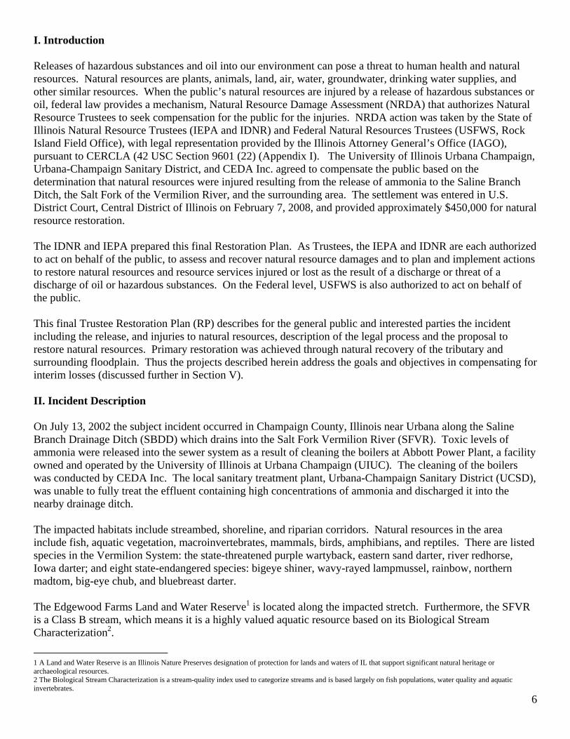
An impact to aquatic life occurred from the point of discharge at the UCSD facility on the SBDD, through the SFVR to its confluence with the Middle Fork of the Vermilion River, approximately 43 miles (Figure 1). Unusual levels of ammonia were detected in the surface water along this stretch over a seven-day period. Lethal concentrations were documented. Not all concentrations were lethal to fish or invertebrates for the entire stream length or for the entire seven-day period of time; however, the stream conditions resulting from the unusual levels of ammonia in the water resulted in natural resource injury. An IDNR fisheries biologist led the fish kill investigation of the SBDD the morning of July 13, 2002. An estimated 9.9 miles of the SBDD habitat were exposed to an unknown amount of ammonia resulting in a “heavy”3 fish kill. The second fish kill investigation performed July 17, reported a 32.4-mile stretch of the SFVR had been impacted, resulting in a “moderate”3 fish kill. The biologist estimated a loss of 115,443 fish, mainly non-game species for the 43-mile impacted area. The species included smallmouth bass, longear sunfish, rock bass, sunfish, shorthead redhorse, silver redhorse, golden redhorse, river redhorse, madtoms, emerald shiner, creek chub, stripe shiner, bluebreast darter, greenside darter, johnny darter, slenderhead darter, northern hogsucker, and white sucker. Besides dead fish, IDNR fisheries biologists also reported seeing dead mussels along the SBDD and dead crayfish along the SFVR stretch. Many of the fish killed are host species that aid in reproduction of mussels. While no direct mortality of adult mussels related to the ammonia release was noted, glochidia and newly metamorphosed mussels were likely injured, preventing successful reproduction in the next year. The IDNR fisheries biologist also noted a greenish color of the water as a result of an algae bloom along the SFVR. Therefore, as these observations indicate, as a result of the release, the stream ecosystem as a whole was disrupted. III. Public Participation Public review of the draft RP is an integral component of the restoration planning process. Through the public review process, the Trustees seek public comment on the approaches used to define and assess natural resource injuries and the projects being proposed to restore injured natural resources or replace services provided by those resources. Public review of the draft RP is consistent with all federal and state laws and regulations that apply to the NRDA process (Appendix I). Following public notice, the draft RP becomes available to the public for a 30-day comment period. Written comments received during the public comment period are considered by the Trustees in preparing the final RP. The defined 30-day public comment period for the draft RP was May 26 through June 25, 2014. During this period no comments were received by the Trustees for consideration in preparing this final RP. Therefore, no significant changes were made when finalizing this Restoration Plan. In the event significant changes are made to the final RP an additional opportunity for public review will be provided. IV. Restoration Planning The Consent Decree entered in the matter United States and the State of Illinois v. Board of Regents of the University of Illinois, et al., Civil Action No. 2:07-cv-02188., describes the concept of a J-vane/Riffle Structure project for the Saline Branch. To view the consent decree in its entirety, visit http://www.dnr.illinois.gov/programs/NRDA/Pages/SalineSalt.aspx. After evaluating the J-vane/riffle structure project and proposed locations, it was decided a broader stream evaluation should take place to determine the most suitable project location and restoration action for the Saline Branch stream system. 3 DNR fish kill procedure includes the following rankings: total kill, heavy kill, moderate kill and light kill. The rankings are based on the impacts to fish as the result of a release (IDNR 1997; AFS 2003).
8
The following information describes the process of identifying and selecting restoration alternatives. For each possible restoration alternative developed, the Trustees identify an action to be taken singly or in combination by the Trustee agency to achieve the restoration, rehabilitation, replacement, and/or acquisition of equivalent natural resources and the services those resources provide. The Trustee shall then select the preferred alternative(s). Possible alternatives are limited to those actions that restore, rehabilitate, replace, and/or acquire the equivalent of the injured resources and services to no more than their baseline, that is, the condition without a discharge or release. The possible alternatives considered by the Trustee that return the injured resources and their lost services to baseline level could range from: intensive action on the part of the Trustee to return the various resources and services provided by those resources to baseline conditions as quickly as possible; to natural recovery with minimal management actions. The Trustees solicited restoration project alternatives from multiple entities (Tables 1 and 3; Figure 2). Such solicitation involved entities including, but not limited to, the Natural Resource Conservation Service (NRCS), United States Geological Survey (USGS), local universities, local soil and water conservation districts, private landowners and not-for-profit organizations. To be eligible for the Natural Resource Restoration Trust funds, the Trustees request that the projects be in the general vicinity of where the incident occurred, preferably in the same watershed (HUC84) where the incident occurred. The Trustees have evaluated all project alternatives that were identified and submitted, which are expected to restore the affected natural resources to pre-incident or baseline levels, and compensate for interim losses. The Trustees utilized evaluation criteria (See Section VI) and restoration expert opinions to evaluate all potential restoration project alternatives. The CERCLA regulations require that the Trustees state their preferred alternative(s) and explain the basis for their selection or rejection of other alternatives (Tables 1 and 3). These Trustee determinations may be modified based on public input and comment. V. Restoration Strategy The goal of the NRDA process is restoration of the injured natural resources and compensation for the interim lost uses of those resources. Restoration actions can be summarized by defining two terms: primary and compensatory5. Primary restoration is action taken to return the injured natural resources and services to baseline on an accelerated time frame by directly restoring or replacing the resource or service. As one form of primary restoration, the CERCLA regulations require that Trustees consider natural recovery of the resource. Trustees may select natural recovery under three conditions: 1) if feasible; 2) if cost-effective primary restoration is not available; or 3) if injured resources will recover quickly to baseline without human intervention. Primary restoration alternatives can range from natural recovery, to actions that prevent interference with natural recovery, to more intensive actions expected to return injured natural resources and services to baseline faster or with greater certainty than natural recovery alone. Compensatory restoration includes actions taken to compensate for the interim losses of natural resources and/or services pending recovery. The type and scale of compensatory restoration depends on the nature of the primary restoration action and the level and rate of recovery of the injured natural resources and/or services. When identifying compensatory restoration alternatives, Illinois Trustees first consider actions that provide services of the same type and quality and that are of comparable value as those lost. If a reasonable range of compensatory actions of the same type and quality and comparable value cannot be found, Trustees then
4 The USGS Hydrologic Unit Code is a sequence of numbers or letters that identify a hydrological feature, such as a drainage basin. The HUC 8 watershed boundary has been selected by the Trustees as an appropriate watershed scale for restoration planning efforts. 5 These two types of restoration actions are OPA regulation terminology however they are conceptually similar to the two components of damages under the CERCLA regulations. Primary restoration has the same objective as the CERCLA concept of “restoration, rehabilitation, replacement and/or acquisition of the equivalent” of injured resources. In both instances, the objective is to return injured resources or services to baseline. The OPA regulations’ “compensatory restoration” has the same objective as “compensable value” under the CERCLA regulations. In both cases, the objective is to compensate for interim losses.
9
consider other compensatory restoration actions that will provide services of at least comparable type and quality as those lost. VI. Evaluation Criteria When selecting the alternative to pursue, the Trustees considered the following factors listed under 43 CFR Subpart E 11.82 Damage Determination phase — alternatives for restoration, rehabilitation, replacement, and/or acquisition of equivalent resources (Appendix I):
(1) Technical feasibility. (2) The relationship of the expected costs of the proposed actions to the expected benefits from the
restoration, rehabilitation, replacement, and/or acquisition of equivalent resources.
(3) Cost-effectiveness.
(4) The results of any actual or planned response actions.
(5) Potential for additional injury resulting from the proposed actions, including long-term and indirect impacts, to the injured resources or other resources.
(6) The natural recovery period determined in 43 CFR sect. 11.73(a)(1).
(7) Ability of the resources to recover with or without alternative actions.
(8) Potential effects of the action on human health and safety.
(9) Consistency with relevant Federal, State, and tribal policies.
(10) Compliance with applicable Federal, State, and tribal laws.
Table 2 lists and further describes the factors provided above, as well as other factors utilized by the Illinois Trustees. These criteria were utilized to screen against the project alternatives (Tables 1 and 3) and a preferred alternative was selected. VII. Proposed Compensatory Restoration Alternatives Primary restoration was achieved through natural recovery of the tributary and surrounding floodplain. Therefore, the focus of this restoration plan is on the proposed compensatory restoration actions. The incident occurred on two streams of variable quality. Therefore, restoration alternatives were selected to address restoration needs with respect to the quality of each stream system. Along the Saline Branch, the preferred alternative includes a project involving the implementation of riffle-pool structures and rain gardens with a monitoring and educational component. The project is located in the vicinity of where the incident began and will restore/sustain habitat for natural resources similar to those lost or injured as a result of the ammonia release (See Section IX). This project will provide benefits to the stream ecosystem as a whole. The preferred restoration alternative selected for the Salt Fork will be described in a Phase II RP. Details of the SBDD project are provided below. All appropriate permits, including, but not necessarily limited to relevant Army Corps of Engineer permits, IDNR Office of Water Resources permits, and IEPA permits, will be sought. Restoration work will not begin until all appropriate permits have been obtained.
10
SALINE BRANCH RESTORATION PROJECT The proposed project involves the unique opportunity to implement both instream and floodplain restoration at one site. The project site is within the Saline Branch at Crystal Lake Park, which is owned by the Urbana Park District (UPD), in Urbana IL (Figure 3). Project components include the design and construction of pool and riffle structures and rain gardens. Monitoring activities and educational outreach are also components of this restoration effort. The pool and riffle structures will stabilize the stream and create deep water habitat which is lacking in the stream system. Water quality will be improved by increasing dissolved oxygen and decreasing sedimentation. Furthermore, the rain gardens will increase water quality of overland flow and increase water storage, thereby, decreasing sedimentation. The rain garden plant diversity and shallow water levels will also provide essential wildlife habitat. The goals of this project are consistent with the Urbana Park District’s master plan for Crystal Lake Park as well as the goals of the Salt Fork/Vermilion River Watershed Implementation Plan, to provide a more sustainable Saline Branch with water quality and habitat enhancements. It is estimated that a minimum of 3 pool/riffle sequences could be installed over an approximately 2000-foot project reach and 2 rain gardens implemented at strategic locations adjacent to parking lots within the Crystal Lake Park property (Figure 3). These restoration efforts are based on restoration concepts and principals proven to be successful in similar Illinois stream and floodplain systems (Figures 8-10). This restoration planning effort is being led by the IDNR with assistance and input from a diverse project team consisting of, but not limited to, the United States Geological Survey, University of Illinois faculty and students, the Urbana Park District, and the United States Fish and Wildlife Service with support from the Prairie Rivers Network. See Figures 4-7 for additional information including site photos. Educational Component: The project’s scope is not such that it can address all the problems associated with the Saline Branch and its watershed. However, the monitoring and educational components included in this proposal increase the overall project scope by allowing an opportunity for people to learn from the project and equip the public with the ability to address other conservation related problems in the watershed. For example, by educating the public the hope is future hazardous substance releases will be decreased and conservation practices will be increased. Therefore, this project has a wide scope for increasing the protection of Illinois streams, watersheds, and other natural resources. The proposed project will involve coordination with local schools and the community for project monitoring, including but not limited to, pre and post biological and geomorphological monitoring. Thus, the monitoring effort will not only provide an evaluation of the project design, it will also explain to the public the benefits of instream and floodplain restoration. Furthermore, the Urbana Park District has a curriculum in place for providing environmental education to school groups and the general public. This curriculum will be enhanced by funding additional education and outreach material specific to the implemented restoration project. VIII. Rationale for Preferred Restoration Alternative The total amount of the Saline Branch/Salt Fork settlement for restoration projects was $450,000. One Hundred Eighty Thousand Dollars was set aside for Saline Branch restoration. The preferred restoration project is projected to cost $180,000. The remaining Natural Resource Restoration Funds will be allocated at a later date for an additional project (Phase II) in the Salt Fork. The preferred restoration project is expected to benefit various natural resources and services associated with natural communities through conservation and restoration (see CERCLA criteria 2, Section VI). The project is expected to satisfactorily compensate for losses sustained by the incidents and benefit public health and safety (see CERCLA criteria 1, 8, Section VI). The Trustees considered that the cost to carry out the projects was
11
clearly feasible given the settlement claim (see CERCLA 2, 3, Section VI). Further primary restoration was achieved through natural recovery of the streams and surrounding floodplain, thus the project address the goals and objectives in compensating for interim losses (see CERCLA criteria 4-7, 9–10, Section VI). For these reasons and others identified in the attached restoration matrix (Table 3), the Trustees believe this project will be suitable to use for compensatory restoration. Post monitoring of the projects will be done to increase the likelihood of a successful restoration effort (see CERCLA criteria 1, Section VI). IX. Proposed Action The Federal (USFWS) and Illinois Trustee Council (IDNR, IEPA and AGO) propose that the subject settlement monies be allocated to fund the proposed restoration project. The Contaminant Assessment Section staff (within IDNR) will work in close coordination with restoration experts to follow all IDNR policies and procedures to ensure the successful operation of the restoration efforts in the Vermilion River Watershed. X. Surveillance and Monitoring Surveillance and monitoring of the pool/riffle structures and rain gardens will be conducted by the project team, including staff from IDNR, UPD, USGS, and UofI, with assistance from local schools and the community. Surveillance will include project oversight and basic observations, including photos of project construction and of the project site pre and post restoration. More in depth monitoring efforts will also be conducted, such as but not limited to: geomorphological, biological, water quality and habitat monitoring pre and post project construction. The geomorphological component will evaluate the effectiveness of the streambank and channel stability measures installed, including bedload transport and diversity of in-stream habitat such as maintenance of pool depth. The biological component for the instream restoration effort will include survey procedures for fish, aquatic insects, and mussels. The basic physical and chemical stream parameters will also be measured to determine the effects of the habitat restoration on the ecosystem. The biological component for the floodplain restoration effort may include vegetation, insect, and herp sampling. Water quality measurements may also be conducted to monitor the inflow and outflow water characteristics. Overall, the monitoring information will document the aquatic life and habitat improvements of the project site. This information will be beneficial in documenting project success or need for adaptive management. The anticipated contractors for this monitoring effort include local Universities and/or volunteers, and as a result, the monitoring effort will benefit both the natural resources and the local community. XI. Fiscal Procedures Restoration funds for the UIUC, UCSD, & CEDA settlement total $450,000.00. It is the intention of IDNR to release funds for Phase I of the restoration effort ($180,000) in calendar year 2014-2016 for restoration activities. Since no objections were posed by the public after the necessary permits are received the funds can be released and restoration activities can begin. IDNR will oversee all restoration activities. The IDNR Springfield headquarters will handle all fiscal transactions. All billings with supporting documentation shall be submitted to the IDNR Springfield Office for review and payment. IDNR fiscal agents will be responsible for the approval and payment of all expenses, obligations and contracts in accordance with the State of Illinois fiscal and procurement procedures.
12
XII. Coordination with other Programs, Plans, and Regulatory Authorities The preferred restoration project will be implemented as a joint effort among partners, including but not limited to, the IDNR, USGS, UofI, USFWS, and the Urbana Park District & the local drainage district as landowners. The partners will provide the technical expertise and finances, and work together to implement conservation practices, maximizing the environmental benefits on the Urbana Park District property within the Saline Branch stream system. This restoration project will comply with all federal, state, and local laws, regulations and policies. XIII. References CCSWCD. 2007. Watershed Implementation Plan for the Upper Salt Fork of the Vermillion River, Champaign
and Vermilion Counties, IL. http://saltfork.nres.illinois.edu/pdfs/Salt%20Fork%20Implementation%20Plan.pdf
LCSMC. 2002. Streambank and Shoreline Protection Manual. Lake County (Illinois) Stormwater
Management Commission and USDA-NRCS. http://www.co.lake.il.us/ http://www.foxriverecosystem.org/PDFs/Streambank%20Shoreline.pdf
United States and the State of Illinois v. Board of Regents of the University of Illinois, et al., Civil
Action No. 2:07-cv-02188
13
XIV. Figures and Tables
Figure 1. Saline Branch and Salt Fork injury area as a result of the 2002 ammonia release; with the approximate location of the Saline Branch-Salt Fork of the Vermilion River within a map of the state of IL.
14 Figure 2. Saline Branch project alternatives (see Tables 1 and 3).
15
Figure 3. The Crystal Lake Park reach in relation to the 2002 fish kill (left). The Crystal Lake Park reach proposed for instream and floodplain restoration (potential locations of instream structures (yellow stars) and rain gardens (yellow circles). The yellow lines mark the upstream and downstream boundaries of the proposed project reach.
16
Figures 4-7 Pictures of the Saline Br. Crystal Lake Park Reach:
Figure 4. Height changes through the riffle in the middle segment of the Crystal Lake Park Saline Branch reach (looking downstream). The proposed project consists of imitating this natural riffle with an enhanced pool depth throughout more of the project reach.
Figure 5. Depth changes (pool) in the middle segment of the Crystal Lake Park Saline Branch reach. The proposed project would create deeper pools in the middle of the stream channel (forcing the flow towards the middle of the stream channel decreases bank erosion).
Figure 7. Stream channel in the downstream segment of the Crystal Lake Park Saline Branch reach (looking downstream).
Figure 6. West bank in the middle segment of the Crystal Lake Park Saline Branch reach. The proposed project would also help stabilize banks.
Rock Riffle structures will create or enhance the riffle-pool flow sequence found in natural channels. In stable systems this alternating riffle-pool sequence dissipates the energy in the stream and allows the stream banks to remain stable with little or no lateral movement (CCSWCD 2007, pg 64).
17
Figure 8. Examples for the types of projects that are being proposed for installation at Crystal Lake Park within and along the Saline Branch: riffle-pool and bio-retention structures.
18
Figure 9. Riffle-Pool proposed design modeling information (obtained from Dr. Rhoads, UIUC).
19
Figure 10. Example design layout of a rain garden (also known as a bio-retention area); a shallow surface depression planted with specially selected native vegetation to capture and treat storm water runoff from rooftops, streets, and parking lots (http://thewmeacblog.org/2011/07/06/lid-overview-of-four-common-lid-tools-managing-rainwater/).
20
6 The total estimated costs for all listed project alternatives exceed the NRDA restoration funds available; therefore, not all alternatives can be funded. Alternatives have been screened against factors listed under 43 CFR Subpart E 11.82 to identify preferred restoration alternatives. All costs are estimates and are subject to change during the final restoration planning phase.
Project title
Subproject Description Benefits/Services Project Location Estimated Cost6 Coordinating Agencies/ Groups
Preferred or Not-Preferred
Instream Restoration
A. j-vane/rock riffle project
install j-vane and rock riffle grade control structures within the Saline Branch
Create deep pool habitat, provide refuge and interstitial spaces for insects, small fish and macroinvertebrates, dissipate energy, stabilize streambanks, increase aeration and add substrate to the channel, reduce nitrates, improve overall water quality.
IDNR streams biologist, consultant, and local drainage district representative identified a location in the vicinity of Rd. 1800E. and Rd. 2000E.
$121,750 (as of 2007 design
estimates, for structures only)
IDNR, IEPA, Champaign Co. SWCD
Not-Preferred; type of structures not preferred (possibly unsustainable) in this location.
B. pool project construct constricted pools within the Saline Branch
Create deep pool habitat, provide refuge and interstitial spaces for macroinvertebrates and fish, dissipate energy, stabilize streambanks, increase aeration and add substrate to the channel, improving overall water quality.
3 possible project locations, adjacent property is all privately owned: downstream of Rd 1800E; downstream of Rd 1900 E; downstream of 1700 N Rd bridge
$120,000 - $390,000 (project
estimates, pending the number of
structures implemented)
IDNR, IEPA, UofI, USGS
Not-Preferred; limited to only instream restoration and no public education component.
Instream and Floodplain Restoration
C. riffle-pool-floodplain project
construct riffle-pool structures and rain gardens within Crystal Lake Park property along Saline Branch
Create deep pool habitat, provide refuge and interstitial spaces for macroinvertebrates and fish, dissipate energy, stabilize streambanks, increase aeration and add substrate to the channel, filter pollutants, regulate flows, and increase infiltration, improving overall water quality. Due to the project location long term monitoring and public education opportunities are available.
Crystal Lake Park, owned by the Urbana Park District
$180,000 - $450,000 (project
estimates, pending the number of
structures implemented)
Preferred; opportunity to implement both instream and floodplain restoration at one site with long term monitoring, maintenance, and public education.
Wetland Restoration
D. Judge Webber Park Wetland
enhance wetlands along Saline Branch
Create habitat for waterfowl and other wildlife, absorb urban storm water and agricultural runoff and filter and recharge groundwater improving overall water quality, reduce sedimentation and contaminant inputs into streams, provide opportunity for conservation education programs.
Urbana Park District has identified area of Judge Webber Park, East Perkins Rd. as a wetland restoration /enhancement site along the Saline Branch.
Contribution to overall project ~ $58,000.
IDNR, IEPA, Champaign Co. SWCD
Not-Preferred; interest in considering a more direct nexus to injured resources through an instream restoration project component.
Conservation Easements
E. Land preservation
preserving natural areas along the Saline Branch and Salt Fork Vermilion River
Provide secure, long-term habitat for fish macroinvertebrates, and other wildlife.
Solicit interest from local landowners to enroll land in conservation easements along the impacted stretch of the Saline Branch and Salt Fork Vermilion River or within the respective area of the incident.
Unknown
F. Land preservation with additional restoration efforts
preserving natural areas along the Saline Branch and Salt Fork Vermilion River, implementing restoration activities including, but not limited to, creating or enhancing wetlands, tree and/or grassland plantings
Provide secure, long-term habitat for fish, macroinvertebrates, and other wildlife, create habitat for wildlife, absorb urban storm water and agricultural runoff and filter and recharge groundwater improving overall water quality, reduce sedimentation and contaminant inputs into the stream.
Solicit interest from local landowners to develop "interceptor wetland" projects or other restoration practices along the impacted stretch of the Saline Branch and Salt Fork Vermilion River or within the respective area of the incident.
Unknown
Table 1. Summary of the Restoration Alternatives for restoring and rehabilitating the resources or equivalent resources that were injured and/or lost as a result of the release of ammonia into the Saline Branch (Phase I restoration effort), Champaign County, Illinois.
21
Table 2. Restoration “factors to consider” (listed in no particular order).
22
Factor
j-vane/rock riffle project (A)
pool project (B)
riffle-pool-floodplain project
(C)
Judge Webber Park Wetland
(D)
Land preservation (E) Land preservation with additional restoration
efforts (F) Technically feasible Yes Yes Yes Yes Yes Yes Expected costs: expected benefits No Yes Yes Yes Not enough information Not enough information Cost-effective Yes Yes Yes Yes Not enough information Not enough information
Results of any actual or planned response actions
No No No No No No
Potential for additional injury resulting from the proposed actions, including long term and indirect impacts, to the injured resources or other resources
Minimal Minimal Minimal Minimal None Minimal
Natural recovery period 1 year (July 2003) 1 year (July 2003) 1 year (July 2003) 1 year (July 2003) 1 year (July 2003) 1 year (July 2003)
Ability of the resources to recover with or without alternative actions
Alternative actions may be necessary
Resources likely to recover without
alternative actions
Resources likely to recover without alternative actions
Alternative actions may be necessary
Alternative actions likely necessary
Alternative actions may be necessary
Potential effect of the action on human health and safety
Minimal Minimal Minimal Minimal Minimal Minimal
Consistency with relevant Federal, State, and tribal laws
Yes Yes Yes Yes Yes Yes
Addresses in-kind habitat in the same watershed
Yes Yes Yes Indirect Indirect Indirect
Provides benefits not being provided by other restoration projects being or having the potential of being planned/implemented/funded under other programs
Yes Yes Yes No No Yes
Addresses/incorporates restoration of “preferred” trust resources or services
Provides long-term benefits No; project potentially unsustainable in stream
system
Yes Yes Yes Yes Yes
May be scaled to appropriate level of resource injury or loss
Yes Not applicable Not applicable Not applicable Not applicable Not applicable
Is consistent with regional planning Yes Yes Yes Yes Yes Yes
Provides benefits sooner Yes Yes Yes No No No
Targets a resource or service that is unable to recover to baseline without restoration action, or that will require a long time to recover naturally
No No No No No No
Restore, rehabilitate, and/or replace habitats of injured resources (including groundwater) and the services that the habitats provide. Acquiring the equivalent may also be a viable option.
Yes Yes Yes Indirect Indirect Indirect
Is acceptable to the public Not applicable Not applicable Yes Not applicable Not applicable Not applicable
Table 3. Summary of Restoration Factors to Consider and the “screening” of the NRDA restoration project alternatives for restoring and rehabilitating the resources or equivalent resources that were injured and/or lost as a result of the release of ammonia into the Saline Branch (Phase I restoration effort), Champaign County, Illinois.
23
Laws, authorities, and guidance associated with NRDA and Natural Resource Injuries. Overview A number of federal and state statutes, regulations, policies, and guidance documents provide a framework for conducting natural resource damage assessments, natural resource injury evaluations and the associated restoration. To administer the program, the Trustees integrate the applicable Federal and State laws, regulations, policies, and guidance documents. Frequently, due to this integration, these terms are sometimes used interchangeably, despite there being a distinct difference between them. Basically, laws written by Congress or the Legislature provide the authority for State Agencies to seek a broad goal. In this instance, laws provide authority for assessment and restoration of natural resources that have been injured by hazardous substances. Federal and/or State agencies can develop regulations when the authority is too general or the matter too complex; hence, needing further explanation of the technical, operational, and legal details necessary to implement laws. Policy and guidance documents are also prepared to assist the process. For natural resource injuries, substantial guidance is found at 43 CFR Part 11; an Act created by the Federal Department of Interior. An example of an applicable State policy guidance is IDNR’s Comprehensive Environmental Review Process – the State’s abridged version of the Federal NEPA (National Environmental Protection Act) process. CERP insures applicable laws & rules are followed before implementing a restoration project on State property.
The major federal laws contributing to the restoration of the injured resources and services framework include the Oil Pollution Act (OPA), the Comprehensive Environmental Response, Compensation, and Liability Act (CERCLA), the Clean Water Act (CWA), Natural Resource Damage Assessment, 43 CFR Part 11, and the National Oil and Hazardous Substances Pollution Contingency Plan (NCP), and the Rivers and Harbors Act of 1899 (Sections 9 and 10). In addition, but not limited to, the State laws relevant for guiding the restoration of injured resources are the Illinois Environmental Protection Act (415 ILCS 5/1, et seq.), the Illinois Natural Areas Preservation Act (525 ILCS 30/1, et seq.), the Illinois Endangered Species Protection Act (520 ILCS 10/1, et seq.), the Interagency Wetland Policy Act of 1989 (20 ILCS 830/1-1, et seq.),),Rivers, Lakes, and Streams Act (615 ILCS 5/18), the Wildlife Code (520 ILCS 5/1.10, et seq.), and Fish and Aquatic Life Code (515 ILCS 5/5-5, et seq.). These laws along with the Comprehensive Environmental Review Process (CERP) are summarized below. Overall, by an integration of applicable laws, regulations, policies and guidance, the State Trustees can purse restoration of injured natural resources. Key Statutes, Regulations, Policies, and Guidance The potentially relevant laws, regulations, policies, and guidance are set forth below. Oil Pollution Act of 1990, 33 U.S.C. §§ 2701, et seq. The Oil Pollution Act establishes a liability regime for oil spills that injure or are likely to injure natural resources and/or the services that those resources provide to the ecosystem or humans. Federal and state agencies and Indian tribes act as Trustees on behalf of the public to assess the injuries, scale restoration to compensate for those injuries, and implement restoration. The National Oceanic and Atmospheric Administration promulgated regulations for the conduct of natural resource damage assessments at 15 C.F.R. Part 990. Natural resource damage assessments are intended to provide the basis for restoring, replacing, rehabilitating, and acquiring the equivalent of injured natural resources and services. The Trustees’ actions are substantially consistent with the regulations found at 15 C.F.R. Part 990. Clean Water Act (Federal Water Pollution Control Act), 33 U.S.C. §§ 1251, et seq. The Clean Water Act is the principal law governing pollution control for water quality of the nation’s waterways. Section 404 of the law authorizes a permit program for the disposal of dredged or fill material into navigable waters. The U.S. Army Corps of Engineers administers the program. In general, restoration projects
XV. Appendix I.
24
that move significant amounts of material into or out of water or wetlands (e.g., hydrologic restoration of marshes) require Section 404 permits. –Under Section 401 of the CWA, restoration projects that involve discharge or fill to wetlands or navigable waters must obtain certification of compliance with state water quality standards (section 401). Comprehensive Environmental Response, Compensation and Liability Act, 42 U.S.C. §§ 9601, et seq. This Act provides the basic legal framework for cleanup and restoration of the nation’s hazardous-substances sites. Generally, parties responsible for contamination of sites and the current owners or operators of contaminated sites are liable for the cost of cleanup and restoration. CERCLA establishes a hazard ranking system for assessing the nation’s contaminated sites with the most contaminated sites being placed on the National Priorities List. Oil Spill Responders Liability Act, 740 ILCS 113/1, et seq. This Act protects oil spill responders from liability for damages that may result from action taken or action omitted in the course of rendering assistance in an oil spill incident that is consistent with the National Contingency Plan. This protection does not apply to the responsible party, or entity which caused the oil spill incident. Under this Act, the responsible party is liable for removal costs and damages to natural resources resulting from a discharge or spill of oil of any kind or in any form, including but not limited to, petroleum, fuel oil, sludge and oil refuse. Illinois Environmental Protection Act, 415 ILCS 5/1, et seq. The Environmental Protection Act is the state law that prohibits most forms of pollution occurring on land, in water, or in the air. It also establishes a liability regime, including enforcement and penalties, for entities that violate the provisions of the Act. The Environmental Protection Act was developed for the purpose of establishing a unified state-wide program for environmental protection and cooperating with other states and with the United States in protecting the environment. It was also developed to restore, protect and enhance the quality of the environment and to assure that adverse effects upon the environment are fully considered and borne by those who cause them. Illinois Natural Areas Preservation Act, 525 ILCS 30/1 et seq. The Act serves to protect any area in Illinois that has been designated as a nature preserve, including the species of plants and animals in each habitat. Any endangered plant and animal species found in designated nature preserves are also protected under this Act. Dedicating and holding an area for natural preserves is also encouraged in this Act. Illinois Endangered Species Protection Act, 520 ILCS 10/1 et seq. This Act gives protection to any plant and animal species on the endangered or threatened list from being moved or destroyed. Any species that the Secretary of the Interior of the United States lists as endangered or threatened is also included on Illinois’s endangered and threatened species list. The Act also provides rules of law for searching any premises suspected of illegally keeping goods, merchandise, or animals, plants, or animal or plant products subject to the Act and seizing such products. Illinois Fish and Aquatic Life Code, 515 ILCS 5/5-5 et seq. and Illinois Wildlife Code, 520 ILCS 5/1.10 et seq. These Codes state that IDNR shall take all measures necessary for the conservation, distribution, introduction and restoration of aquatic life and wildlife, and they provide protection for aquatic life and wildlife from any person who causes waste, sewage, thermal effluent, or any other pollutant to enter into the waters of the State or habitat supporting the wildlife, which causes the death of aquatic life or wildlife. The IDNR, acting through the IAGO, has the authority to bring action against such persons to recover the value of any and all aquatic life or wildlife that is destroyed, related costs in determining such value, and any other fines or penalties provided for by these Codes.
25
Interagency Wetland Policy Act of 1989, 20 ILCS 830/1 et seq. This Act states that state agencies are responsible for preserving, enhancing, and creating wetland areas for the purpose of increasing quality and quantity of the State’s wetland resource base. The goal behind the Act is that there shall be no overall net loss of the State’s existing wetland acres or their functional value due to State supported activities. Comprehensive Environmental Review Process (CERP) Internal process within IDNR that reviews any action taken by the Department that may alter any chemical, physical, or biological conditions of air, land, or water, as well as any alterations to standing structures. CERP staff will review project proposal to see if any damages will occur to threatened and endangered species, wetlands, INAI sites, or cultural resources. Other resources such as migratory birds, fisheries, forests, prairies, streams, riparian corridors, and site aesthetics may also be considered. If staff determines that adverse effects are likely, a CERP sign-off may include project modifications. Rivers, Lakes, and Streams Act 615 ILCS 5/18 No person is allowed to fill or deposit rock, earth, sand, or other material, or any refuse matter of any kind or description or build or commence the building of any wharf, pier, dolphin, boom, weir, breakwater, bulkhead, jetty, causeway, harbor, or mooring facilities for watercraft, or any other structure, with the exception of duck blinds, in public a water body of the State without first submitting plans, data, and other important information to the Department of Natural Resources of the State and receiving a permit signed by the Director of the Department. Under this act, no person is allowed to build, deposit, or discharge any materials into Lake Michigan unless the Illinois Environmental Protection Agency permits one to do so under subsection (a) of section 39 of the Environmental Protection Act. Rivers and Harbors Act of 1899, Sections 9 and 10 9. It is unlawful to build any structure in or across waters of the United States until plans are submitted and approved by Secretary of Transportation, Chief of Engineers, and Secretary of Army and consent is given by Congress. Under permission of the legislation of the State, a person may build in or across waters whose navigable parts lie wholly in that state. The approval required by this section of the location and plans or any modification of plans of any bridge or causeway does not apply to any bridge or causeway over waters that are not subject to the ebb and flow of the tide and that are not used and are not susceptible to use in their natural condition or by reasonable improvement as a means to transport interstate or foreign commerce. 10. It is unlawful to build obstacles that prohibit navigation, unless authorized by Congress, and building of any structure outside harbor lines or where no harbor lines have been established is prohibited unless authorized by Chief of Engineers and Secretary of War. It is also unlawful to fill or modify any plan or structure within limits of breakwaters or the channel of any navigable waters of the United States unless approved by Chief of Engineers and Secretary of War. 43 CFR Part 11 – Natural Resource Damage Assessment CERCLA and CWA provide that natural resource trustees may assess damages to natural resources resulting from a discharge of oil or a release of hazardous substance covered under CERCLA and/or CWA. Trustees may seek to recover those damages and under National Oil and Hazardous Substances Pollution Contingency Plan (NCP) trustees can seek compensation for injuries to natural resources that may not be addressed by response actions of NCP. 40 CFR part 300.605 – National Oil and Hazardous Substances Pollution Contingency Plan State trustees shall act on behalf of the public as trustees for natural resources, including their supporting ecosystems, within the boundary of a state or belonging to, managed by, controlled by, or appertaining to such state. The governor of a state is encouraged to designate a state lead trustee to coordinate all state trustee responsibilities with other trustee agencies. The state lead trustee should have ready access to appropriate state officials with environmental protection, emergency response, and natural resource responsibilities. The EPA
26
Administrator or USCG Commandant or their designees may appoint the state lead trustee as a member of the Area Committee. Response strategies should be coordinated between the state and other trustees for specific natural resource locations in an inland or coastal zone and should be included in the Fish and Wildlife and Sensitive Environments Plan annex of the ACP. 15 CFR Part 990 – Natural Resource Damage Assessment The Oil Pollution Act of 1990 (OPA) provides the designation of federal, state, and, if designated by the Governor of the state, local officials to act on behalf of the public as trustees for natural resources and for the designation of Indian tribe and foreign officials to act as trustees for natural resources on behalf of, respectively, the tribe or its members and the foreign government. This part may be used by these officials in conducting natural resource damage assessments when natural resources and/or services are injured as a result of an incident involving an actual or substantial threat of a discharge of oil. This part is not intended to affect the recoverability of natural resource damages when recoveries are sought other than in accordance with this part.