Final Scoping Report – Proposed Mareetsane Batho-Batho Solar PV Facility SEF REF: 504744
Page ii
PURPOSE OF DOCUMENT A period of 30 calendar days (05 June 2013 – 08 July 2013 ) has been provided to registered Interested and Affected Parties (I&APs) and State Departments for the review and commenting phase of the Final Scoping Report. All registered (I&APs) as well as State Departments have been notified of this review period. The Final Scoping Report contains the following information:
• A description of the project, including project motivation;
• Discussion of applicable alternatives;
• A description of the environment affected by the project;
• The public participation process; and • The plan of study for the Environmental Impact Reporting (EIR) phase.
The Final Scoping Report can be viewed at the following venue:
Name of public venue Name of Contact Person Contact Number(s) Viewing Times
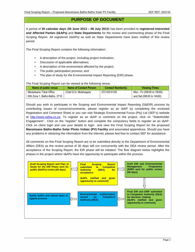
Should you wish to participate in the Scoping and Environmental impact Reporting (S&EIR) process by contributing issues of concerns/comments, please register as an I&AP by completing the enclosed Registration and Comment Sheet or you can visit Strategic Environmental Focus (Pty) Ltd (SEF’s) website at http://www.sefsa.co.za. To register as an I&AP or comment on the project, click on “Stakeholder Engagement”. Click on the “register” button and complete the compulsory fields to register as an I&AP. Click on client login and use your details to login and view the Final Scoping Report for the proposed Mareetsane Batho-Batho Solar Photo Voltaic (PV) Fac ility and associated appendices. Should you have any problems in obtaining the information from the internet, please feel free to contact SEF for assistance. All comments on this Final Scoping Report are to be submitted directly to the Department of Environmental Affairs (DEA) as the review period of 30 days will run concurrently with the DEA review period. After the acceptance of the Scoping Report, the EIR phase will be initiated. The flow diagram below highlights the phases in the project where I&APs have the opportunity to participate within the process.
Draft Scoping Report and Plan of Study for the EIR Phase sent for public (I&APs) review (40 days)
Final Scoping Repor t submitted to Competent Authority (DEA) for acceptance I&APs notified and given opportunity to comment)
Draft EIR and Environmental Management Programme (EMP) sent for public review (40 days)
Final EIR and EMP submitted to Competent Authority (DEA) for decision -making (I&APs notified and given opportunity to comment)
Environmental Authorisation issued by Competent Authority (DEA)
Notify I&APs and inform them of appeal process
Final Scoping Report – Proposed Mareetsane Batho-Batho Solar PV Facility SEF REF: 504744
Page iii
PROJECT SUMMARY Project Name The Mareetsane Batho-Batho Solar Photovoltaic (PV) Facility.
Farm Name and Portion
The site has been surveyed and a draft SG diagram has been compiled (refer to Appendix 4). The SG diagram has been submitted to the SG’s office for registration. The site falls within a parent portion of the Setlagoli Native Reserve and has an SG Code: BOIO00000000030400000. The farm is Tribal Land administered by Chief G.G. Motshegare.
Brief Development Overview
The proposed Mareetsane Batho-Batho Solar PV Facility will generate approximately 30 Mega Watts (MW) of power for distribution into the National Grid, specifically for the benefit of the local Mareetsane Batho-Batho Community located to the north-east of the proposed development. Three alternative powerline routes are proposed to connect the proposed solar plant to the National Grid – via one of the two existing Eskom substations (located to the north-east and north-west of the proposed plant).
Solar Technology
The proposed PV facility will use Crystalline Silicon PV technology; however this may change depending on whether or not the Applicant will use single axis tracking or fixed mounting solutions for the facility. The preferred alternative will be highlighted during the Environmental Impact Reporting Phase when these alternatives are assessed by the appointed Engineers during the detailed design of the facility.
Generation Capacity 30 MW.
Development Footprint
The proposed solar plant site is approximately 140ha in extent. The proposed overhead powerlines predominantly fall within the existing Eskom powerline servitudes; however, their exact footprint/ corridor width and length will be detailed in the Environmental Impact Report (EIR).
Development / Structure Height Detailed designs of the solar plant and powerlines will be provided within the EIR.
Development / Structure Orientation The development / structure orientation will be provided within the EIR.
Lay Down Area Dimensions To be addressed within the EIR. Site Photographs Refer to Appendix 2.
Final Scoping Report – Proposed Mareetsane Batho-Batho Solar PV Facility SEF REF: 504744
Page iv
ENVIRONMENTAL ASSESSMENT PRACTITIONER Strategic Environmental Focus (Pty) Ltd (SEF) is a privately owned company and was formed in 1997 with the objective of providing expert solutions to pressing environmental issues. SEF is one of Africa’s largest multi-disciplinary consultancies assisting the private sector and government in managing the sustainability of our natural resources. SEF has been proactively providing these sustainable solutions for over 15 years, with offices located across the major centres of South Africa, as well as offering global expertise through years of experience providing these sustainable solutions on many international projects. As a proudly South African company, SEF has been responding and resolving issues of environmental sustainability in the development sector, for over a decade and a half, and we have been privileged and honoured to have been part of the development of some of our country’s most prized national landmarks, in both the private and public domain. As a business steeped in entrepreneurship, we pride ourselves on being innovative and future focussed, driven through our unique offering of having all types of environmental consultant specialists under one roof. SEF’s core environmental experts have extensive experience in dealing with Environmental Impact Assessments (EIAs), Public Participation Processes, Architectural and Landscape Architecture, Mining and Environmental Management. SEF also has a team of specialist practitioners such as specialists in Heritage Impact Assessments (HIA), Wetland Delineation and Functional Assessments; Wetland/ Riparian Rehabilitation, Aquatic Assessments; Ecological (Fauna, Avifauna and Flora) Assessment, Visual Impact Assessments (VIAs), Soils and Agricultural Potential Assessments, Socio-Economic Assessments, etc.
SEF is a Qualifying Small Enterprise (QSE) and a Level 2 contributor in terms of the Broad Based Bla ck Economic Empowerment Act, 2003 (Act No. 53 of 2003) and has a procurement recognition level of 135%. SEF commits itself to comply with the requirements and the implementation of a Quality Management System (QMS). The QMS will be reviewed and implemented to continually improve efficiency and effectiveness of the organisation. SEF uses a “green” approach to anything we embark on. We believe in using technology to our and the environment’s best advantage. We encourage the use of green alternatives such as telephone and video conferencing instead of travelling for workshops and meetings and Compact Discs (CDs) instead of printed material, where possible. The following project team members are involved in this S&EIR application process. Table 1: Project Team Members
Name Organization Project Role
Ms Vici Napier SEF Project Manager
Ms Mpho Manyabe SEF Environmental Manager
Mr Mandla Zuma SEF Environmental Assistant and facilitator for the Public Participation Process
SEF’s Vision SEF is a national sustainability consultancy which provides integrated and innovative Social,
Biophysical & Economic solutions while fostering st rategic stakeholder relationships, underpinned by SEF’s core values.
SEF’s Mission SEF offers holistic and innovative sustainable solu tions in response to global challenges.
Final Scoping Report – Proposed Mareetsane Batho-Batho Solar PV Facility SEF REF: 504744
Page v
Ms Vici Napier Vici has obtained her Master’s Degree in Conservation Biology from the University of Cape Town and has been an Environmental Assessment Practitioner (EAP) for more than 7 years. She provides internal and external technical training on all environmental processes and applications. She has been responsible for numerous environmental applications ranging from Basic Assessments (BAs) and Scoping and EIRs in terms of NEMA, as well as various mining applications in terms of the MPRDA. Vici is currently a Project Manager for SEF, focusing on Strategic Environmental Assessments (SEAs) and capacity building through training and skills transfer. She also provides technical supervision of projects, project leadership on large scale environmental assessments, management of multi-disciplinary teams and quality control on EIAs, BAs and strategic projects. She is registered with the South African Council for Natural Scientific Professions. Ms Mpho Manyabe Mpho has obtained her National Diploma in Environmental Sciences from the Tshwane University of Technology (TUT). Mpho has 6 years of work experience in the field of environmental management from various consulting companies. Mpho has previously worked as an assistant environmental consultant conducting EIAs for the mining industries and service stations, and also other small industries. She has also been involved in numerous Public Participation Processes (PPPs) throughout the Gauteng Region. She previously had been employed as an environmental scientist where she was involved in environmental assessment projects, for Parastatals, National Departments and Municipalities from 2008 to 2011. She has also been involved in Safety, Health and Environmental (SHE) management for private and public entities where she had been the overall project manager for such projects. Mr Mandla Zuma Mandla obtained a BSc in Environmental Management from the University of Zululand in 2009. He worked with the Department of Environmental Affairs (DEA) (Oceans and Coasts) as an Intern in the Coastal Conservation Strategies section for four months; where the main responsibilities included looking after coastal information. He then worked with SEF as an Intern for seven months and was later appointed as an Environmental Assistant. Mandla has been assisting in compiling BAs and EIAs and related tasks. He has been involved in tasks requiring good legislation interpretation and also assists with public and authority consultation. Table 2: Contact Details of Environmental Assessmen t Practitioner Name Contact Details
Final Scoping Report – Proposed Mareetsane Batho-Batho Solar PV Facility SEF REF: 504744
Page vi
EXECUTIVE SUMMARY
1 INTRODUCTION
Strategic Environmental Focus (Pty) Ltd (SEF) has been appointed by Kgatelopele Private Equity and Venture Capital (Pty) Ltd (KPEVC) to undertake an environmental application process for the proposed Mareetsane Batho-Batho Solar Photovoltaic (PV) Facility and associated infrastructure (i.e. powerlines). A Scoping and Environmental Impact Reporting (S&EIR) process is being conducted for this project based on triggered listed activities within the Environmental Impact Assessment (EIA) Regulations of 2010 [Government Notice (GN) No’s 543; 544; 545 and 546] promulgated in terms of the National Environmental Management Act, 1998 (Act No. 107 of 1998) (NEMA). The purpose of the Scoping phase is to describe the proposed activity and those reasonable alternatives that have been identified as well as the receiving environment that may be affected by the proposed project. Based on the aforementioned aspects the Scoping phase highlights the potential environmental impacts that may occur based on the proposed development. The Scoping phase then also dictates which specialist assessments must be undertaken, during the Environmental Impact Reporting (EIR) phase, to investigate and assess potential environmental impacts. The report further describes the required Public Participation Process (PPP) followed during the Scoping phase as well as how it will be carried out during the EIR phase. The Draft Scoping Report was made available to I&APs and State Departments from 16 April 2013 – 28 May 2013 for review and commenting. The report has been finalised and the Final Scoping Report has been submitted to the Department of Environmental Affairs (DEA) and I&APs for review. The purpose of this Final Scoping Report is to provide all I&APs with an opportunity to assess whether or not their comments/ concerns submitted have been included and adequately addressed. All comments on this Final Scoping Report are to be submitted directly to the DEA as the commenting and review period of the Final Scoping Report (i.e. 30 calendar days) will run concurrently with the DEA’s review period. The DEA will, based on this Final Scoping Report, issue a decision on whether or not the application may proceed to the EIR phase.
2 BRIEF PROJECT DESCRIPTION
The proposed Mareetsane Batho-Batho Solar PV Facility will be located on Tribal Land approximately 10 km south-west of the Batho-Batho Village within the jurisdiction of the Ratlou Local Municipality (RLM), Ngaka Modiri Molema District Municipality (NMMDM) in the North West Province and falls within the Quarter Degree Grid Cell 2625AB (refer to the Locality Map in Appendix 1). The proposed site for the solar plant development is approximately 140 hectares (ha) in extent. As indicated above, the footprint (width and length) of the associated powerlines will be detailed in the EIR. Two high voltage Eskom substations and associated high and medium voltage powerlines are located to the north-east and north-west of the proposed site. The substations are approximately 10-12km from the proposed solar plant site. A railway line runs along the south-eastern boundary of the proposed site (please refer to the Locality Map in Appendix 1). The facility will generate approximately 30 Mega Watts (MW) of electricity which will be fed into the National Grid (specifically to provide for additional capacity for the Mareetsane Local Community) via one of the two abovementioned existing Eskom substations. Three alternative powerline routes are proposed and are being considered (Appendix 1). The preferred alternative will be identified through the EIR phase to follow.
Final Scoping Report – Proposed Mareetsane Batho-Batho Solar PV Facility SEF REF: 504744
Page vii
3 KEY IMPACTS
The following key impacts were identified and will be carried forward into the EIR phase for further investigation and assessment: Biophysical Impacts:
• Potential impacts on surface water resources that occur in close proximity to the site (the non-perennial Morokwa River is situated to the west and south of the site) and possible patches of wetlands scattered throughout the site (please refer to Appendix 4);
• Potential impacts of increased surface water run-off (viz. increased soil erosion) associated with the establishment of hard surfaces and vegetation clearing (mainly during the construction phase);
• Potential impacts on ground and surface water quality due to hydrocarbon spillages from vehicles during the construction phase of the development;
• Potential impacts on soils due to hydrocarbon spillages from vehicles during the construction and operational phase of the development;
• Destruction of flora within the proposed area (including known protected species - Acacia erioloba (Camel Thorn) and Boophone disticha (Poison Bulb)), stemming from construction activities such as vegetation clearing and topsoil stripping within the site;
• Faunal displacement mainly during the construction phase of the project; and
• Adverse impacts on avifauna (the Provincially Protected Afrotis afroides (Northern Black Korhaan) was confirmed on site.) as a result of potential habitat loss, additional overhead powerlines and the potential reflections of the solar panels (during the operation phase).
Socio-Economic Impacts:
• Increased dust and noise generation during the construction phase;
• Change in the visual character of the area;
• Potential increased access to electricity by the local community;
• Potential impacts on heritage resources (a graveyard with 4 visible graves was observed just 20m outside of the northern boundary of the proposed site);
• Job creation during the construction and operational phases of the proposed project;
• Broader local economic development benefits for the communities within a 50 km radius as a result of the proposed Solar PV farm;
• Tourism attraction through visitation to the solar facility; and
• Develop education and training initiatives to enable the youth to develop skills especially in Science and Technology.
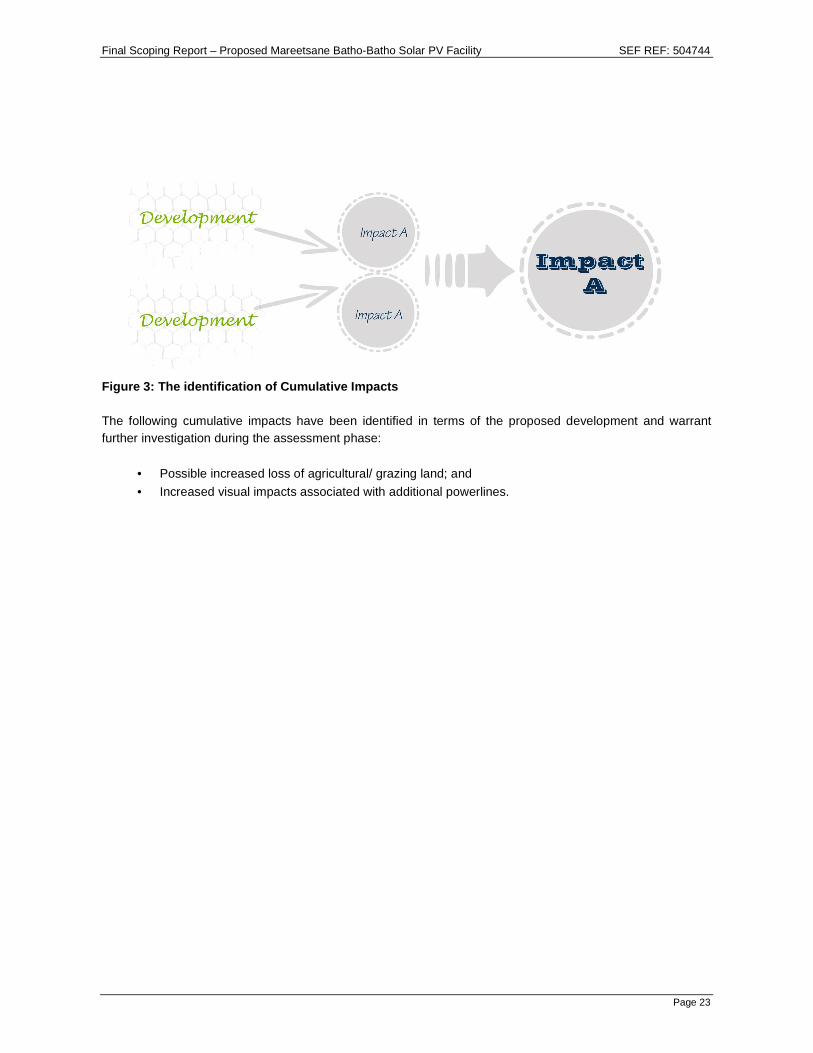
Cumulative Impacts:
• Possible increased loss of agricultural/ grazing land; and
• Increased visual impacts associated with additional powerlines.
4 PROJECT ALTERNATIVES
To give effect to the principles of the NEMA and Integrated Environmental Management (IEM), an EIA should assess a number of reasonable and feasible alternatives that may achieve the same end result as that of the preferred project alternative. The following alternatives have been identified as part of this Scoping exercise: Alternative 1: Site/ Location Alternatives: A larger piece of land was considered for potential development with the intention of utilising only a portion deemed suitable for development. As a result, the proposed site (part of the Tribal Land) was the only site identified as feasible for the establishment of the solar plant, due to the following:
• Site is largely flat and suitable for the solar PV panels;
Final Scoping Report – Proposed Mareetsane Batho-Batho Solar PV Facility SEF REF: 504744
Page viii
• Geotechnical soil conditions are suitable for structural foundation requirements conducive for construction of a Solar PV facility
• High levels of solar insolation have been independently confirmed using Meteonorm software on the piece of land proposed for the solar facility. The site has been determined to have an annual average insolation of 2164 kWh/m2
• The proposed site is optimally located in close proximity to existing Eskom powerlines and nearby substations; and
• Eskom has indicated there is capacity to absorb the MW proposed to one of the nearest substations
• Availability of land within relatively close proximity to the local community it is intended to serve (this was the only site the land owner (Tribal Chief) has given consent for in terms of leasing it for this proposed development (Appendix 4)).
• The site is easily accessible.
• Off-take electricity agreements opportunities exist as the proposed land is within reasonable distance to mining activities in the area.
Alternative 2: Layout/ Design Alternatives: Alternative layout/ design plans will evolve from the findings of specialist studies that will be undertaken to inform the EIR phase. Design and layout alternatives will be proposed based on the environmental sensitivities identified on site. These alternatives will be investigated and assessed within the EIR phase. Alternative 3: Route Alternatives: Three (3) powerline route alternatives for the proposed project are being considered. Route A (approximately 18km in length) runs parallel to the existing Eskom powerline towards the substation situated to the north-west of the proposed site. Route B (approximately 15km in length) runs parallel to the existing Eskom powerline towards the substation situated north-east of the proposed site. Route C (approximately 46km in length) is an extension of Route B and continues parallel to existing Eskom powerlines towards the substation situated to the north-west of the proposed site. Refer to the Locality Map in Appendix 1. The preferred powerline route alternative will be identified during the EIR phase to follow. Alternative 4: Technology Alternatives: Various technology alternatives have been considered and will be investigated/ assessed during the EIR phase of the proposed project. These include the following alternatives:
• Crystalline silicon PV technology with either fixed mounting or a tracking system;
• Thin-film PV technology;
• Concentrating PV technology; and
• Nanotechnology approaches. The various technologies that will be considered will have implications varying from cost to effectiveness. Alternative 5: No Development Alternative: The ‘no-go’ or ‘do nothing’ alternative would be applicable if the proposed development is not approved by the DEA. This would imply that the status quo of the site will remain. Should the proposed development not be implemented, the area will not be affected by any construction-related or operational phase impacts. Therefore, the present state of the biophysical, social and economic environment will remain, unaffected. Under these circumstances there would be no changes to the environment along the proposed routes and
Final Scoping Report – Proposed Mareetsane Batho-Batho Solar PV Facility SEF REF: 504744
Page ix
site. However, the reliability of electricity supply to the Batho-Batho Community would remain a significant concern unless other sources of power generation and distribution are provided. With increasing economic activity and demand for electricity, the regional impact of electricity failures would be significant and increasingly severe. The local community will benefit from the socio-economic spin-offs from the development.
5 CONCLUSIONS AND RECOMMENDATIONS
In accordance with GN No. R.543, the Final Scoping Report is aimed at describing the proposed activity and those reasonable alternatives that have been identified as well as the receiving environment that may be affected by the proposed Mareetsane Batho-Batho Solar PV Facility. In accordance with the EIA Regulations, an identification of relevant legislation and guidelines is also given as well as a description of the PPP that will be followed. Comments and/or concerns received from I&APs during the review period of the Draft Scoping Report have been incorporated into this Final Scoping Report for further investigation during the EIR phase to follow. The Final Scoping Report has been submitted to the DEA for consideration, together with the Plan of Study (PoS) for the EIR phase and other relevant supporting information. The EAP proposes that, on the basis of the information contained in this Scoping Report, that the DEA accepts the Scoping Report and PoS for the EIR phase and allow the EAP to proceed with the EIR phase of the project, such that the more pertinent issues can be thoroughly investigated and assessed, in terms of their significance and impact. The ability to mitigate any of the potential impacts identified in this Scoping Report will also be investigated during the EIR phase and summarised into a working/ dynamic Environmental Management Programme (EMP) for consideration by I&APs and ultimately by the DEA.
Final Scoping Report – Proposed Mareetsane Batho-Batho Solar PV Facility SEF REF: 504744
Page x
TABLE OF CONTENTS
ENVIRONMENTAL ASSESSMENT PRACTITIONER ............. ......................................................................... IV
EXECUTIVE SUMMARY .................................................................................................................................... VI 1 INTRODUCTION ................................................................................................................................... VI 2 BRIEF PROJECT DESCRIPTION ......................... ............................................................................... VI 3 KEY IMPACTS ....................................... .............................................................................................. VII 4 PROJECT ALTERNATIVES .............................. .................................................................................. VII 5 CONCLUSIONS AND RECOMMENDATIONS ................... ................................................................. IX
TABLE OF CONTENTS ................................. ..................................................................................................... X
LIST OF FIGURES ............................................................................................................................................. XI LIST OF TABLES .................................... ........................................................................................................... XI LIST OF APPENDICES ................................ ...................................................................................................... XI LIST OF ABBREVIATIONS AND ACRONYMS ................ ............................................................................... XII GLOSSARY OF TERMS ................................. ................................................................................................. XIV
A-1.2 Surrounding Land Use ......................................................................................................................1
A-1.3 Details of the Project .........................................................................................................................2
A-2 LEGAL REQUIREMENTS APPLICABLE TO THIS APPLICATION . ....................................................2
A-2.1 The National Environmental Management Act, 1998 (Act No. 107 of 1998) and Environmental Impact Assessment Regulations of 2010 ........................................................................................................2
A-2.2 National Water Act, 1998 (Act No. 36 of 1998) ................................................................................5
A-2.3 National Environmental Management: Waste Act, 2008 (Act No. 59 of 2008) ................................6
A-2.4 National Heritage Resources Act, 1999 (Act No. 25 of 1999) ..........................................................6
A-2.5 Other Legal Requirements ................................................................................................................6
A-3 DETAILS OF THE APPLICANT .......................... ................................................................................ 10
A-4 NEED AND DESIRABILITY OF THE PROJECT .............. .................................................................. 11
SECTION B: THE RECEIVING ENVIRONMENT ....................................................................................... 13
B-2.5 Air ................................................................................................................................................... 16
SECTION C: ENVIRONMENTAL IMPACT ASSESSMENT (EIA) PROCESS ..... ..................................... 18
C-1 APPROACH TO THE EIA ............................... ..................................................................................... 18
C-2 GUIDING PRINCIPLES FOR AN EIA ..................... ............................................................................ 18
C-3 S&EIR TECHNICAL PROCESS ........................... ............................................................................... 19
C-3.1 Pre-application Consultation with the DEA .................................................................................... 20
C-3.2 Application for Authorisation .......................................................................................................... 20
C-3.3 Information Gathering .................................................................................................................... 20
Figure 1: The eight guiding principles for the EIA process ................................................................................ 19
Figure 2: Flow diagram of the Scoping and EIR process .................................................................................. 19
Figure 3: The identification of Cumulative Impacts ........................................................................................... 23
Figure 4: Description of bio-physical assessment parameters with its respective weighting ............................ 31
LIST OF TABLES
Table 1: Project Team Members ......................................................................................................................... iv
Table 2: Contact Details of Environmental Assessment Practitioner ................................................................... v
Table 3: Surrounding Land Use Table ..................................................................................................................2
Table 4: Ecological and conservation status of the Mareetsane and Morokwa Rivers according to the NSBA (Nel et al., 2004). ............................................................................................................................................... 14
Table 5: Faunal species observed during the field scan. .................................................................................. 15
Table 6: Example of an Impact Table ................................................................................................................ 32
Final Scoping Report – Proposed Mareetsane Batho-Batho Solar PV Facility SEF REF: 504744
Page xii
LIST OF ABBREVIATIONS AND ACRONYMS
ASGISA Accelerated Shared Growth Initiative for South Africa
BA Basic Assessment
CD Compact Disk
DEA Department of Environmental Affairs (previously DEAT)
DEAT Department of Environmental Affairs and Tourism
DoE Department of Energy
DWA Department of Water Affairs
EAP Environmental Assessment Practitioner
EIA Environmental Impact Assessment
EIR Environmental Impact Reporting
EIS Ecological Importance and Sensitivity
EMP Environmental Management Programme
EPC Engineering, Procurement and Construction Management Companies
GIS Geographic Information System
GN Government Notice
ha Hectares
HDI Historically Disadvantaged Individual
HIA Heritage Impact Assessment
I&APs Interested and Affected Parties
IDP Integrated Development Plan
IEM Integrated Environmental Management
IRP Integrated Resource Plan
KPEVC Kgatelopele Private Equity and Venture Capital (Pty) Ltd
ME Mitigation Efficiency/ Effectiveness
MLM Mafikeng Local Municipality
MPRDA Minerals and Petroleum Resources Development Act, 2002 (Act No. 28 of 2002)
MW Mega Watt
NEMA National Environmental Management Act, 1998 (Act No. 107 of 1998)
NEMBA National Environmental Management: Biodiversity Act, 2004 (Act No. 10 of 2004)
NFEPA National Freshwater Ecosystems Priority Areas
NGP New Growth Path
NMMDM Ngaka Modiri Molema District Municipality
NSBA National Spatial Biodiversity Assessment
NWA National Water Act, 1998 (Act No. 36 of 1998)
Final Scoping Report – Proposed Mareetsane Batho-Batho Solar PV Facility SEF REF: 504744
Page xiii
OEM Original Equipment Manufacturers
PES Present Ecological State
PoS Plan of Study
PPP Public Participation Process
PV Photovoltaic
QMS Quality Management System
QSE Qualifying Small Enterprise
RLM Ratlou Local Municipality
SACAA South African Civil Aviation Authority
SAHRA South African Heritage Resources Agency
SANBI South African Botanical Institute
SEA Strategic Environmental Assessment
SEF Strategic Environmental Focus (Pty) Ltd
SFM Significance Following Mitigation
SG Surveyor General
SHE Safety, Health and Environmental
S&EIR Scoping and Environmental Impact Reporting
TOPS Threatened or Protected Species
ToR Terms of Reference
TUT Tshwane University of Technology
VIA Visual Impact Assessment
WMA Water Management Area
WM With Mitigation Measures
WML Waste Management License
WOM Without Mitigation Measures
WUL Water Use License
WULA Water Use Licence Application
Final Scoping Report – Proposed Mareetsane Batho-Batho Solar PV Facility SEF REF: 504744
Page xiv
GLOSSARY OF TERMS
Alternative
In relation to a proposed activity, means different means of meeting the general purpose and requirements of the activity, which may include alternatives to—
(a) the property on which or location where it is proposed to undertake the activity;
(b) the type of activity to be undertaken;
(c) the design or layout of the activity;
(d) the technology to be used in the activity;
(e) the operational aspects of the activity; and
(f) the option of not implementing the activity.
Applicant Any person who applies for an authorisation to undertake an activity or to cause such activity to be undertaken as contemplated in sections 24(5), 24M and 44 of the National Environmental Management Act, 1998 (Act No. 107 of 1998).
Cumulative Impact
Cumulative impact, in relation to an activity, means the impact of an activity that in itself may not be significant, but may become significant when added to the existing and potential impacts eventuating from similar or diverse activities or undertakings in the area.
Ecology The study of the interrelationships between organisms and their environments.
Endangered Species
A species of organisms facing a very high risk of extinction.
Environment
The surroundings within which humans exist and that are made up of – (i) the land, water and atmosphere of the earth; (ii) micro-organisms, plant and animal life; (iii) any part or combination of (i) and (ii) and the interrelationships among and between them; and (iv) the physical, chemical, aesthetic and cultural properties and conditions of the foregoing that influence human health and wellbeing.
Environmental Impact Assessment
Systematic process of identifying, assessing and reporting environmental impacts associated with an activity and includes basic assessment and S&EIR.
Environmental Management Programme
A working document on environmental and socio-economic mitigation measures, which must be implemented by several responsible parties during all the phases of the proposed project.
Indigenous Species
A species is defined as native (or indigenous) to a given region or ecosystem if its presence in that region is the result of only natural processes, with no human intervention.
Interested and Affected Party
Any person or groups of persons who may express interest in a project or be affected by the project, positively or negatively.
No-go/ Do nothing alternative
The option of not undertaking the proposed activity or any of its alternatives. The no-go alternative also provides the baseline against which the impacts of other alternatives should be compared.
Stakeholder Any person or group of persons whose live(s) may be affected by a project.
Study Area Refers to the entire study area encompassing all the alternatives as indicated on the study area or locality map.
State Department
Any department or administration in the national or provincial sphere of government exercising functions that involve the management of the environment.
Final Scoping Report – Proposed Mareetsane Batho-Batho Solar PV Facility SEF REF: 504744
Page 1
SECTION A: INTRODUCTION Strategic Environmental Focus (Pty) Ltd (SEF) has been appointed by Kgatelopele Private Equity and Venture Capital (Pty) Ltd (KPEVC) to undertake an environmental application process for the proposed Mareetsane Batho-Batho Solar Photovoltaic (PV) Facility and associated infrastructure (i.e. powerlines). A Scoping and Environmental Impact Reporting (S&EIR) process is being conducted for this project based on triggered listed activities within the Environmental Impact Assessment (EIA) Regulations of 2010 [Government Notice (GN) No’s 543; 544; 545 and 546] promulgated in terms of the National Environmental Management Act, 1998 (Act No. 107 of 1998) (NEMA). The purpose of the Scoping phase is to describe the proposed activity and those reasonable alternatives that have been identified as well as the receiving environment that may be affected by the proposed project. Based on the aforementioned aspects the Scoping phase highlights the potential environmental impacts that may occur based on the proposed development. The Scoping phase then also dictates which specialist assessments must be undertaken, during the Environmental Impact Reporting (EIR) phase, to investigate and assess potential environmental impacts. The report further describes the required Public Participation Process (PPP) followed during the Scoping phase as well as how it will be carried out during the EIR phase. The Draft Scoping Report was made available to I&APs and State Departments from 16 April 2013 – 28 May 2013 for review and commenting. The report has been finalised and the Final Scoping Report has been submitted to the Department of Environmental Affairs (DEA) and I&APs for review. The purpose of this Final Scoping Report is to provide all I&APs with an opportunity to assess whether or not their comments/ concerns submitted have been included and adequately addressed. All comments on this Final Scoping Report are to be submitted directly to the DEA as the commenting and review period of the Final Scoping Report (i.e. 30 calendar days) will run concurrently with the DEA’s review period. The DEA will, based on this Final Scoping Report, issue a decision on whether or not the application may proceed to the EIR phase.
A-1 DESCRIPTION OF PROPOSED ACTIVITY
A-1.1 Locality The proposed Mareetsane Batho-Batho Solar PV Facility will be located on Tribal Land approximately 10 km south-west of the Batho-Batho Village within the jurisdiction of the Ratlou Local Municipality (RLM), Ngaka Modiri Molema District Municipality (NMMDM) in the North West Province and falls within the Quarter Degree Grid Cell 2625AB (refer to the Locality Map in Appendix 1).
A-1.2 Surrounding Land Use Two high voltage Eskom substations and associated high and medium voltage powerlines are located to the north-east and north-west of the proposed site. The substations are approximately 10-12km from the proposed solar plant site. The local community of Batho-Batho (proposed to benefit from this development) is located approximately 10km to the north-east. A railway line runs along the south-eastern boundary of the proposed site. Aerial images indicate that the vegetation is largely natural but overgrazed and land use data indicates poor soil potential for intensive agriculture since these are sandy, eutrophic red soils. The predominant land use is that of grazing.
Final Scoping Report – Proposed Mareetsane Batho-Batho Solar PV Facility SEF REF: 504744
Page 2
To further place the site in context, the land uses within all four major compass directions are described in the table below. Table 3: Surrounding Land Use Table
Direction Land Use Distance (m)
North Vacant Land Adjacent to the site
East Railway Line Adjacent to the site.
Vacant Land East of the adjacent railway line
South Vacant Land Adjacent to the site
West Vacant Land Adjacent to the site
A-1.3 Details of the Project The proposed Mareetsane Batho-Batho Solar PV Facility will be located on Tribal Land approximately 10 km south-west of the Batho-Batho Village within the jurisdiction of the RLM, NMMDM in the North West Province and falls within the Quarter Degree Grid Cell 2625AB (refer to the Locality Map in Appendix 1). The proposed site for the solar plant development is approximately 140 hectares (ha) in extent. As indicated above, the footprint (width and length) of the associated powerlines will be detailed in EIR. Two high voltage Eskom substations and associated high and medium voltage powerlines are located to the north-east and north-west of the proposed site. The substations are approximately 10-12km from the proposed solar plant site. A railway line runs along the south-eastern boundary of the proposed site. The facility will generate approximately 30 Mega Watts (MW) of electricity which will be fed into the National Grid (specifically to provide for additional capacity for the Mareetsane Local Community) via one of the two abovementioned existing Eskom substations. Three alternative powerline routes are proposed and are being considered (Appendix 1); the preferred alternative will be identified through the EIR phase to follow.
A-2 LEGAL REQUIREMENTS APPLICABLE TO THIS APPLICATI ON The aim of this component of the report is to provide a brief overview of the pertinent policies as well as legal and administrative requirements applicable to the proposed project. The application form informing the DEA of intent to obtain an Environmental Authorisation was submitted on 20 March 2013. Subsequent to the submission of the Application for Environmental Authorisation form, the DEA issued the project with the following reference numbers: DEA Ref: 14/12/16/3/3/2/514 and NEAS Ref: DEA/EIA/0001785/2013. The legislation, guidelines and policies applicable to this project are as follows:
A-2.1 The National Environmental Management Act, 19 98 (Act No. 107 of 1998) and Environmental Impact Assessment Regulations of 2010
The EIA Regulations, promulgated under the NEMA, focus primarily on creating a framework for co-operative environmental governance. NEMA provides for co-operative environmental governance by establishing principles for decision-making on matters affecting the environment, institutions that will promote co-operative governance and procedures for co-ordinating environmental functions exercised by State Departments and to provide for matters connected therewith. In terms of the EIA Regulations of 2010 and activities listed in GN No. R544 and R 546 (requiring a Basic Assessment (BA) process) and GN No. R 545 (requiring a S&EIR process), the following listed activities are deemed by the Environmental Assessment Practitioner (EAP) to be applicable to the proposed Mareetsane Batho-Batho Solar PV Facility and associated powerlines based on the information provided by the client.
Final Scoping Report – Proposed Mareetsane Batho-Batho Solar PV Facility SEF REF: 504744
Page 3
It must be noted that activities requiring a BA process, as well as activities requiring a S&EIR process are triggered by the proposed development. Therefore, according to the below listed activities, a situation arises, whereby; the legal requirements of the activities listed in terms of GN No. R 545 of 2010 supersedes those of the activities listed in terms of GN No. 544 and 546 of 2010, and as such this application shall undergo a S&EIR process .
GNR No &
Activity
Number
Activity Description Project Description
GN No. R
545 of 18 June 2010
1 The construction of facilities or infrastructure for the generation of
electricity where the electricity output is 20 megawatts or more.
The proposed solar power plant will
generate approximately 30MW of
electricity.
15
Physical alteration of undeveloped, vacant or derelict land for
residential, retail, commercial, recreational, industrial or
institutional use where the total area to be transformed is 20
hectares or more;
except where such physical alteration takes place for:
(i) linear development activities; or
(ii) agriculture or afforestation where activity 16 in this
Schedule will apply.
The extent of the proposed site is
approximately 140 ha.
GN No. R
544 of 18 June 2010
9
The construction of facilities or infrastructure exceeding 1000 metres in length for the bulk transportation of water, sewage or storm water -
(i) with an internal diameter of 0,36 meters or more; or
(ii) with a peak throughput of 120 litres per second or more,
excluding where:
a. such facilities or infrastructure are for bulk transportation of
water, sewage or storm water or storm water drainage inside a
road reserve; or
b. where such construction will occur within urban areas but
further than 32 meters from a watercourse, measured from the
edge of the watercourse.
The proposed development may require service infrastructure to be installed. This will be confirmed during the EIR phase.
10
The construction of facilities or infrastructure for the transmission and distribution of electricity
(i) outside urban areas or industrial complexes with a
capacity of more than 33 but less than 275 kilovolts
The proposed solar plant will require electrical distribution lines to evacuate electricity generated by the plant to the National Grid.
11
The construction of: (i) canals;
(ii) channels;
(iii) bridges;
(iv) dams;
(v) weirs;
(vi) bulk storm water outlet structures;
(vii) marinas;
(viii) jetties exceeding 50 square metres in size;
(ix) slipways exceeding 50 square metres in size;
(x) buildings exceeding 50 square metres in size; or
(xi) infrastructure or structures covering 50 square metres or
more
where such construction occurs within a watercourse or within 32 meters of a watercourse, measured from the edge of a watercourse, excluding where such construction will occur behind the development setback line.
Due to the known presence of wetlands and nearby watercourses – the proposed development may require infrastructure and/or buildings within 32m of a watercourse.
Final Scoping Report – Proposed Mareetsane Batho-Batho Solar PV Facility SEF REF: 504744
Page 4
18
The infilling or depositing of any material of more than 5 cubic
metres into, or the dredging, excavation, removal or moving of
soil, sand, shells, shell grit, pebbles or rock or more than 5 cubic
metres from:
(i) a watercourse;
(ii) the sea;
(iii) the seashore;
(iv) the littoral active zone, an estuary or a distance of 100
metres inland of the high-water mark of the sea or an
estuary, whichever distance is the greater-
but excluding where such infilling, depositing , dredging, excavation, removal or moving; (i) is for maintenance purposes undertaken in accordance
with a management plan agreed to by the relevant environmental authority; or
(ii) occurs behind the development setback line.
Due to the presence of wetlands and watercourses on site, there may be a requirement to move soil within or in close proximity to wetlands and/or watercourses.
22
The construction of a road, outside urban areas,
(i) with a reserve wider than 13.5 meters; or
(ii) where no reserve exists where the road is wider than 8
meters,
Access to site exists through various gravel roads. For the construction and operational phases of the proposed project, topsoil, grass and vegetation may be removed to provide better access for the life of the project.
GN No. 546 of 18 June 2010
4
The construction of a road wider than 4 metres with a reserve less than 13.5 metres. (c) In the North West: (i) outside urban areas, in:
(aa) A protected area identified in terms of NEMPAA, excluding conservancies;
(bb) National Protected Area Expansion Strategy Focus areas; (cc) Sensitive areas as identified in an environmental
management framework as contemplated in chapter 5 of the Act and as adopted by the competent authority;
(dd) Sites or areas identified in terms of an International Convention;
(ee) Critical biodiversity areas (Terrestrial Type 1 and 2 and Aquatic Type 1) as identified in systematic biodiversity plans adopted by the competent authority or in bioregional plans;
(ff) Core areas in biosphere reserves; (gg) Areas within 10 kilometres from national parks or world
heritage sites or 5 kilometres from any other protected area identified in terms of NEMPAA or from a biosphere reserve.
The proposed site falls within an identified biodiversity node and corridor in terms of the North-West Province Biodiversity Conservation Assessment Technical Report.
14
The clearance of area of 5 hectares or more of vegetation where 75% or more the vegetative cover constitutes indigenous vegetation In the North West: (i) All areas outside urban areas
Due to construction activities on the site, there may be a need to clear vegetation of 5 hectares or more that may be 75% or more indigenous.
Final Scoping Report – Proposed Mareetsane Batho-Batho Solar PV Facility SEF REF: 504744
Page 5
The mentioned listed activities are deemed to include activities that could potentially have a detrimental impact on the social and biophysical state of an area and as such, are required to undergo a S&EIR) process.
A-2.2 National Water Act, 1998 (Act No. 36 of 1998) The National Water Act, 1998 (Act No. 36 of 1998) (NWA) aims to provide management of the national water resources to achieve sustainable use of water for the benefit of all water users. This requires that the quality of water resources is protected as well as integrated management of water resources with the delegation of powers to institutions at the regional or catchment level. The purpose of the Act is to ensure that the nation’s water resources are protected, used, developed, conserved, managed and controlled in responsible ways. Of specific importance to this application is Section 19 of the NWA, which states that an owner of land, a person in control of land or a person who occupies or uses the land which thereby causes, has caused or is likely to cause pollution of a water resource must take all reasonable measures to prevent any such pollution from occurring, continuing or recurring and must therefore comply with any prescribed waste standard or management practices. Due to water resources identified on site (i.e. wetlands) through the Environmental Feasibility Assessment, and the close proximity of the Morokwa River, the proposed development may trigger the following water uses listed in Section 21 of the NWA:
(c) impeding or diverting the flow of water in a watercourse; g) disposing of waste in a manner which may detrimentally impact on a water resource; and i) altering the bed, banks, course or characteristics of a watercourse.
Accordingly, the proposed project may thus require a Water Use Licence (WUL), which is administered by the Department of Water Affairs (DWA).
16
The construction of: (iii) Buildings with a footprint exceeding 10 square metres in
size; or (iv) Infrastructure covering 10 square metres or more where such construction occurs within a watercourse or within 32 meters of a watercourse, measured from the edge of a watercourse, excluding where such construction will occur behind the development setback line. (c) In North West: (i) Outside urban areas, in: (aa) A protected area identified in terms of NEMPAA, excluding
conservancies; (bb) National Protected Area Expansion Strategy Focus areas; (cc) World Heritage Sites; (dd) Sensitive areas as identified in an environmental
management framework as contemplated in chapter 5 of the Act and as adopted by the competent authority;
(ee) Sites or areas identified in terms of an International Convention;
(ff) Critical biodiversity areas or ecosystems service areas as identified in systematic biodiversity plans adopted by the competent authority or in bioregional plans;
(gg) Core areas in biosphere reserves; (hh) Areas within 10 kilometres from national parks or world
heritage sites or 5 kilometres from any other protected area identified in terms of NEMPAA or from a biosphere reserve.
The proposed site falls within an identified biodiversity node and corridor in terms of the North-West Province Biodiversity Conservation Assessment Technical Report.
Final Scoping Report – Proposed Mareetsane Batho-Batho Solar PV Facility SEF REF: 504744
Page 6
A-2.3 National Environmental Management: Waste Act, 2008 (Act No. 59 of 2008) The Act aims to reform the law regulating waste management in order to protect the health and the environment by providing reasonable measures for the prevention of pollution and ecological degradation and for securing ecologically sustainable development; to provide for institutional arrangements and planning matters; to provide for national norms and standards for regulating the management of waste by all spheres of government; to provide for specific waste management measures; to provide for the licensing and control of waste management activities; to provide for the remediation of contaminated land; to provide for the national waste information system; to provide for compliance and enforcement; and to provide for matters connected therewith. The proposed project does not trigger the need for a Waste Management Licence (WML) due to the following reasons:
• During construction, workers will not be housed/ based on site and will be transported to and from the site every day – thus only chemical toilets will be provided during the construction phase.
• During the operational phase – no persons will be permanently based on site as the plant is “self-sustaining” except for occasional maintenance visits – thus septic tanks/ French drains will be installed at the main building – but the “treatment” threshold is below that requiring a WML (i.e. below 2 000 m3 per annum).
A-2.4 National Heritage Resources Act, 1999 (Act No . 25 of 1999) This Act legislates the necessity for Cultural and Heritage Impact Assessment (HIA) in areas earmarked for development, which exceed 0.5 hectares (ha) and where linear developments (including roads) exceed 300 metres in length. The Act makes provision for the potential destruction to existing sites, pending the archaeologist’s recommendations through permitting procedures. Permits are administered by the North West Provincial Heritage Resources Authority. Although no heritage resources/ sites were identified during the desktop survey and brief site scan for the Environmental Feasibility Assessment, a graveyard with 4 visible graves was observed just 20m outside of the northern boundary of the proposed site. The oldest of these graves was dated 1961 while the youngest was dated 2006.
A-2.5 Other Legal Requirements
A-2.5.1 Constitution of the Republic of South Africa Act, 1 996 (Act No. 108 of 1996) The Constitution of the Republic of South Africa Act, 1996 (Act No. 108 of 1996) (here in after referred to as the Constitution) has major implications for environmental management. The main effects are the protection of environmental and property rights, the change brought about by the sections dealing with administrative law, such as access to information, just administrative action and broadening of the locus standi of litigants. These aspects provide general and overarching support and are of major assistance in the effective implementation of the environmental management principles and structures of the NEMA. Section 24 in the Bill of Rights of the Constitution specifically states that: Everyone has the right -
• To an environment that is not harmful to their health or well-being; and
• To have the environment protected, for the benefit of present and future generations, through reasonable legislative and other measures that -
o Prevent pollution and ecological degradation; o Promote conservation; and
Final Scoping Report – Proposed Mareetsane Batho-Batho Solar PV Facility SEF REF: 504744
Page 7
o Secure ecologically sustainable development and use of natural resources while promoting justifiable economic and social development.
A-2.5.2 National Environmental Management: Biodiversity Act , 2004 (Act No. 10 of 2004) The purpose of the National Environmental Management: Biodiversity Act, 2004 (Act No. 10 of 2004) (NEM: BA) is to provide for the management and conservation of South Africa’s biodiversity within the framework of the NEMA and the protection of species and ecosystems that warrant national protection. As part of its implementation strategy, the National Spatial Biodiversity Assessment was developed. This Act is applicable to this application for environmental authorisation, in the sense that it requires the project applicant to consider the protection and management of local biodiversity.
A-2.5.3 Subdivision of Agricultural Land Act, 1970 (Act No. 70 of 1970) The purpose of the Act is to control the subdivision and, in connection therewith, the use of agricultural land. The Minister of Agriculture, Forestry and Fisheries (“Minister of Agriculture”) must consent to the proposed subdivision.
A-2.5.4 Conservation of Agricultural Resources Act, 1983 (A ct No. 43 of 1983) To provide for control over the utilization of the natural agricultural resources of the Republic in order to promote the conservation of the soil, the water sources and the vegetation and the combating of weeds and invader plants; and for matters connected therewith.
A-2.5.5 Occupational Health and Safety Act, 1993 (Act No. 8 5 of 1993) The object of the Act is to provide for the health and safety of persons at work and for the health and safety of persons in connection with the use of plant and machinery; the protection of persons other than persons at work against hazards to health and safety arising out of or in connection with the activities of persons at work; to establish an advisory council for occupational health and safety; and to provide for matters connected therewith.
A-2.5.6 Civil Aviation Act, 2009 (Act No. 13 of 2009) To repeal, consolidate and amend the aviation laws giving effect to certain International Aviation Conventions; to provide for the control and regulation of aviation within the Republic; to provide for the establishment of a South African Civil Aviation Authority with safety and security oversight functions, to provide for the establishment of an independent Aviation Safety Investigation Board in compliance with Annexure 13 of Chicago Convention, to give effect to certain provisions of the Convention on Offences and Certain other Acts Committed on Board Aircraft; to give effect to the Convention for the Suppression of Unlawful Acts against the Safety of Civil Aviation; to provide for the National Aviation Security Program; to provide for additional measures directed at more effective control of the safety and security of aircraft, airports and the like; and to provide for matters connected thereto. Approval will be sought from the South African Civil Aviation Authority (SA CAA) for the proposed solar plant and associated infrastructure to ensure safe conduct of civil aviation.
A-2.5.7 Promotion of Access to Information Act, 2000 (Act N o. 2 of 2000) The Act recognises that everyone has a constitutional right of access to any information held by the state and by another person when that information is required to exercise or protect any rights. The purpose of the Act is
Final Scoping Report – Proposed Mareetsane Batho-Batho Solar PV Facility SEF REF: 504744
Page 8
to foster a culture of transparency and accountability in public and private bodies and to promote a society in which people have access to information that enables them to exercise and protect their rights.
A-2.5.8 Integrated Environmental Management (IEM) IEM is a philosophy for ensuring that environmental considerations are fully integrated into all stages of the development process. This philosophy aims to achieve a desirable balance between conservation and development [Department of Environmental Affairs (DEAT, 1992)]. The IEM guidelines intend encouraging a pro-active approach to sourcing, collating and presenting information in a manner that can be interpreted at all levels. The DEA Integrated Environmental Management Information Series guidelines are also considered during this S&EIR application process.
A-2.5.9 The National Building Regulations and Building Stan dards Act, 1997 (Act No. 103 of 1997)
The object of the Act is to promote the promotion of uniformity in the law relating to the erection of buildings in the areas of jurisdiction of local authorities for the prescribing of building standards and for matters connected therewith.
A-2.5.10 National Spatial Biodiversity Assessment The National Spatial Biodiversity Assessment (NSBA) classifies areas as worthy of protection based on its biophysical characteristics, which are ranked according to priority levels.
A-2.5.11 Protected species – Provincial Ordinances Provincial ordinances were developed to protected particular plant species within specific provinces. The protection of these species is enforced through permitting requirements associated with provincial lists of protected species. Permits are administered by the Provincial Departments of Environmental Affairs. The Environmental Feasibility Assessment identified Threatened (Provincially protected) flora and fauna species present on the proposed site. These included the following:
• Acacia erioloba; • Brachystelma cacum; and
• Baiana bainesii. The Provincially Protected Afrotis afroides (Northern Black Korhaan) was confirmed on site. Out of twelve protected faunal species that were identified on the larger study area of the Environmental Feasibility Assessment, there are only 9 species that may occur on site. These are:
• Atelerix frontalis frontalis (South African Hedgehog)- Near Threatened;
• Felis nigripes (Black footed Cat)- Vulnerable;
• Lemniscomys rosalia (Single-striped Grass Hare)- Data Deficient;
• Poecilogale albinucha (African Side-stripe Weasel)- Data Deficient;
• Rhinolophus clivosus (Geoffroy's Horseshoe Bat)- Near Threatened;
• Rhinolophus darlingi (Darling's Horseshoe Bat)- Near Threatened;
• Rhinolophus denti (Dent's Horseshoe Bat)- Near Threatened; and
Final Scoping Report – Proposed Mareetsane Batho-Batho Solar PV Facility SEF REF: 504744
Page 9
• Suncus varilla (Lesser Dwarf Shrew)- Data Deficient.
A-2.5.12 Accelerated Shared Growth Initiative for South Afri ca (ASGISA) Accelerated Shared Growth Initiative for South Africa (ASGISA) resulted from Government's commitment to halve unemployment and poverty by 2014 and was launched in February 2006. ASGISA is not a government programme but a national initiative supported by key groups in the economy viz, Business, Labour, State-owned enterprises, Government economic agencies, Entrepreneurs and all spheres of government. In regard to improving national energy efficiency, the National Electricity Response Team, convened by government in February 2008, has giving consideration to amending housing regulations and specifications to make solar-heating systems and energy efficiency mandatory.1.
A-2.5.13 New Growth Path (NGP) In 2010, President Jacob Zuma, endorsed by the Cabinet, proposed a New Growth Path (NGP) for the South African economy. Later in the same year, Minister Ebrahim Patel, released the Framework of the New Economic Growth Path, which includes many elements of the ASGISA framework and outlines the Government’s revised approach to economic policy. The NGP is an integrated macroeconomic path, designed to deal with some of the major structural fault lines of the South African economy, namely, unemployment, poverty, and low growth rates. The NGP places critical responsibilities on the State towards job creation. As such, the private sector should also play a vital role in helping achieve the Government’s objectives. The creation of five million jobs over the next decade is the central political economy goal of the New Growth Path. Furthermore, the New Growth Path places emphasis on the means of achieving global competitiveness via a series of integrated socioeconomic interventions that improve the country’s vital infrastructure, its human resources, and its global strategic alliances. The NGP focuses on the following:
• Increasing employment intensity of the economy;
• Reducing the cost to improve infrastructure and address competitiveness; • Balancing spatial development of rural areas and poorer provinces;
• Reducing the carbon intensity of the economy; and
• Creating opportunities in changing regional and global environments. The NGP identifies five other priority areas as part of the programme to create jobs, through a series of partnerships between the State and the private sector.
• Green economy: expansions in construction and the p roduction of technologies for solar, wind and biofuels is supported by the draft Energy on Integrated Resource Plan (IRP). Clean manufacturing and environmental services are projec ted to create 300 000 jobs over the next decade.
• Agriculture: jobs will be created by addressing the high input costs and up scaling processing and export marketing. Support for small holders will include access to key inputs. Government will explore ways to improve working and living conditions for the country’s 660 000 farm workers. The growth path also commits the Government to unblocking stalled land transfers, which constrain new investment.
• Mining: calls for increased mineral extraction and improving infrastructure and skills development. It
1 http://www.info.gov.za/asgisa/
Final Scoping Report – Proposed Mareetsane Batho-Batho Solar PV Facility SEF REF: 504744
Page 10
focuses support for beneficiation on the final manufacture of consumer and capital goods, which can create large-scale employment. It foresees the establishment of a state mining company concentrating on beneficiation and enhanced resource exploitation in competition with a strong private mining sector.
• Manufacturing: calls for re-industrialisation in the South African economy based on improving performance through innovation, skills development and reduced input costs in the economy. The document targets a doubling of South Africa’s research and development investment to 2% of gross domestic product by 2018.
• Tourism and other high-level services: hold employment potential and the framework calls for South Africa to position itself as the higher education hub of the African continent.
A-2.5.14 Ngaka Modiri Molema District Municipality: Integrat ed Development Plan 2011/ 2012 The NMMDM’s vision is to be a District Municipality (DM) that delivers sustainable quality services with the aim to:
• Eliminate the service backlogs by 2014 by delivering on the constitutional obligation to provide basic services to all;
• Develop economic sectors and spatial localities in accordance with people‘s need and potential; and • Protect and use the natural resource base in a sustainable manner.
The NMMDM Integrated Development Plan (IDP) specifies Mining and Energy as two of the important pillars for sectoral growth and economic development in the DM. The proposed development is in alignment with the IDP as it intends to produce energy which is greatly needed by the DM for its economic growth.
A-2.5.15 Ratlou Local Municipality: Integrated Development P lan 2010 The following objectives from the RLM’s IDP are relevant to the proposed project:
• Ensure sustainable provision of services;
• Promote social and economic development;
• Promote safe and healthy environments; and
• Give priority to the basic needs of communities. The proposed Mareetsane Batho-Batho Solar PV Facility is located within the rural area of the municipality, and the IDP specifically states that the empowerment programmes should be focused on the rural areas. The proposed development will contribute to local economic development through job creation and the potential attraction of investment into the area, which are two of the IDP goals. The spin-offs would ensure the future sustainability of this area and enable the local communities to improve their quality of life.
A-3 DETAILS OF THE APPLICANT The details of the project applicant are:
Final Scoping Report – Proposed Mareetsane Batho-Batho Solar PV Facility SEF REF: 504744
Page 11
KPEVC is a South African 100% black youth owned company developing solar renewable energy projects in South Africa.
• KPEVC was launched in 2011, with the main objective of becoming one of South Africa’s leading providers of Solar PV renewable energy;
• The company works with landowners, rural communities, technology Original Equipment Manufacturers (OEMs), Engineering, Procurement and Construction Management Companies (EPCs), competent authorities, regulators and investors to develop projects;
• In each project, KPEVC plays the role of project developer and manager, coordinating all specialist studies, site identification, project structure, selecting strategic partners and arranging financing; and
• To ensure successful development of projects, KPEVC has relationships and partnerships with local and international service providers in engineering, construction, project management and financial expertise.
A-4 NEED AND DESIRABILITY OF THE PROJECT At present, South Africa relies heavily on fossil fuels to provide electricity for the country. This practice is not sustainable, associated with very high environmental and socio-economic impacts. As such, there is a drive to locate and identify feasible, sustainable and environmentally acceptable alternatives for electricity generation. One such alternative is solar power; this form of electricity generation is sustainable and is associated with “lesser” environmental impacts, for example, there are limited air quality impacts and impacts on water resources are minimal and effectively mitigated. There is global pressure on countries to decrease their reliability on fossil fuels and to increase their share of renewable energy. In 2008, approximately 93% of South Africa’s electricity was produced from coal, with nuclear energy making up most of the remainder. The growing energy demand and concern over the environmental impact of coal-fired power generation has led to government outlining a programme that would attempt to change this situation (Goldie-Scott, 2011). In South Africa, The IRP for South Africa, which was initiated by the Department of Energy (DoE) which is a “co-ordinated schedule for generation expansion and demand-side intervention programmes, taking into consideration multiple criteria to meet electricity demand”. The IRP has undergone two rounds of public participation, and has been recommended to Cabinet for adoption. The Policy-Adjusted IRP for South Africa is a major step towards building local industry clusters, as well as assisting South Africa in fulfilling the commitments made at the Copenhagen Climate Change Summit, in terms of mitigating climate change (IRP2, 2011). The current goal set for the sustainable renewable energy industry, is 17.8 GW of renewables by 2030. This mix of renewables will come mainly from wind, solar, biomass and small-scale hydro. This will result in a total of 42 % of new power generation being sourced from renewables. The proposed project is a responding to the high demand of energy in the North West Province. The generation of additional “green” power will reduce the burden of electricity demand on the existing coal fuelled power stations, and in turn reduce the amount of fossil fuels required for electricity production, which will have positive benefits on the receiving environment as a whole. The proposed project is located in a suitable area for the utilisation of solar energy. With the facility located in the rural area of Mareetsane, more people will have access to electricity as a basic need, which is in line with municipal objectives. Mareetsane is generally a very poor community. The unemployment rate stands at over 42.3% of the population. This project will bring hope to the community through socio-economic development spin-offs. Jobs will be created during the construction, operations and maintenance of the project. This will contribute towards uplifting the community and 60% of jobs will be for the previously disadvantaged local community. The Mareetsane community is unable to sustain itself and mostly rely on subsistence farming and small scale
Final Scoping Report – Proposed Mareetsane Batho-Batho Solar PV Facility SEF REF: 504744
Page 12
cattle breeding. There is no development taking place in the area. There is an abundance of un-used land suitable for solar energy generation. The development of the project will foster rural development, skills development and enterprise development through the community trust to be established. In terms of education, the project will bring an opportunity to put practical rural education into action since some learners and teachers in the area have never seen a facility of this nature, yet it is included in the curriculum for technology related learning areas.
Final Scoping Report – Proposed Mareetsane Batho-Batho Solar PV Facility SEF REF: 504744
Page 13
SECTION B: THE RECEIVING ENVIRONMENT In order to, with any level of confidence, assess the potential impacts of the proposed Mareetsane Batho-Batho Solar PV Facility and associated powerlines on the receiving environment, one needs to first assess the baseline conditions found over the site. Using this Status Quo, one can then, broadly speaking, determine the likely impacts that will emanate from a specific development typology on a well-defined receiving environment. Prior to the commencement of this environmental process, the Applicant undertook a desktop Environmental Feasibility Assessment (Appendix 4) for the proposed site and a larger study area that encompassed the existing Eskom substations located to the north-east and north-west of the proposed site – in order to broadly identify any sensitive environments that may be impacted on by associated powerline infrastructure. The report concluded the following: The study area and proposed solar farm site coincide with areas that are known or expected to contain Threatened Ecosystems, protected watercourses (including wetlands) and Threatened (Provincially and Nationally Protected) floral and faunal species. Only the larger study area encompasses Critically Important / Hyperdiversity Areas, known FEPA wetlands and wetland clusters as well as important heritage/ cultural resource areas. A Biodiversity Node and associated Biodiversity Corridors traverse the majority of the study area and the proposed site falls within these Corridor buffer zones. The site scan also revealed sensitive environments present on site (such as isolated wetlands and patches of threatened and protected flora). Details from the Environmental Feasibility Assessment have been included in the sections that follow.
B-1 BIOPHYSICAL ENVIRONMENT
B-1.1 Geology and Geotechnical Suitability
The site is dominated by sandy soils and Clovelly and Hutton soils2. According to the available geological data, the site is underlain by Kalahari sands that consist predominantly of recent Aeolian deposits. During the Geotechnical Assessment’s field investigation it was found that the Aeolian sand is underlain by limestone that has progressed into Hardpan calcrete. A geotechnical Investigation has already been undertaken during the Environmental Feasibility ssessment. In the report, the geological map indicates that the Aeolian sand and limestone (Qw) are underlain by rhyolite (Ra) to the east and lavas and schist’s (Zg) to the south (Envitech Solutions, 2012 – Please refer to Appendix 4 for the Geotechnical Investigation Report. Considering that the site is underlain by Aeolian sand that consists of silty and clayey sands that are underlain by either nodular ferricrete or Calcrete, excavation of the material on site should pose no problem as the material classifies as medium to intermediate in terms of earthworks excavation. The in-situ soil is not suitable as road building material due to the non-cohesive nature of the sand. Due to the collapsible nature of the Aeolian sands, on-site pre-consolidation of the foundations should be carried out to prevent any potential subsidence, and the only major concern could be a the potential for a perched groundwater table during the rainy season in the lower lying areas. However, this can be overcome by proper design of a stormwater and groundwater control system.
B-1.2 Soils and Agricultural Potential The site is composed of soils of poor suitability for arable agriculture where climate permits. The predominant land use in the surrounding area is grazing. The Environmental Feasibility Assessment identified the site as not being suitable for agriculture.
2 Department of Environmental Affairs and Tourism 2001, ENPAT. Pretoria: DEAT
Final Scoping Report – Proposed Mareetsane Batho-Batho Solar PV Facility SEF REF: 504744
Page 14
B-1.3 Topography and Hydrology The topography of the proposed site is flat. There are isolated wetlands scattered throughout the site and non-perennial rivers in close proximity of the site. The study area and proposed site are located within Quaternary Catchment D41B within the Lower Vaal Water Management Area (WMA) and Molopo sub-management area. The main rivers of this WMA are the Molopo, Harts and Vaal. All rivers associated with the study site area classified as non-perennial. The Mareetsane River flows through the north of the greater study area, while the Morokwa River flows through the central region. To the south, several small rivers flow into the study area including; the Mosime, Tlhakajeng, Makgelejane, Mosime, Thalatau, Sepane and Sebengi Rivers. Only the Mareetsane and Morokwa Rivers are listed on the National Spatial Biodiversity Assessment (Nel et al., 2004) and a summary of their ecological and conservation status is listed in the table below: Table 4: Ecological and conservation status of the Mareetsane and Morokwa Rivers according to the NSBA (Nel et al. , 2004).
River name Signature Ecological Status Conservation Status
Mareetsane Kalahari Basin Class B: Largely natural Not threatened
Morokwa Kalahari Basin Class B: Largely natural Not threatened
On viewing the proposed site (on Google Earth) in context of the immediate surrounding landscape, there is a clear visible band of vegetation (dense bushveld - significantly different to that of the north-eastern half of the site) linked to the downstream non-perennial river (the Morokwa River) to the west of the proposed site. Due to the presence of small (possibly) isolated wetlands identified along the south-western boundary of the site, supports the likelihood that the south-western half of the site is, most likely, hydrologically connected to the non-perennial river to the west.
B-1.4 Climate The North West Province is located in the north west of South Africa, bordering Botswana. The province has warm climate with the temperatures ranging from 17 ºC to 31 ºC in the summer and from 3 ºC to 21 ºC in the winter. The annual rainfall in the province totals about 360 mm, with almost all of it falling during the summer months, between October and April (Wikipedia North West, 2013).
B-1.5 Flora and Fauna Vegetation and geology on site appears to resemble certain characteristics of the Western Highveld Sandy Grassland, as described in Mucina and Rutherford (2006), with flat topography, sandy soils and Clovelly and Hutton soils. The landscape is composed of plains of overgrazed grassland (Photograph 1) with woody species such as Acacia hebeclada and Terminalia sericea forming dense thickets in the west and southern corners of the proposed site. A few isolated patches of exotic species, such as Opuntia sp. and Agave sp. were observed. The proposed site is located within the Western Highveld Sandy Grassland vegetation type. This vegetation type has flat to gently undulating plains and comprises of short, dry grassland with some woody species occurring in bush clumps. It is classified as Critically Endangered (DEA, 2011) with only a small portion statutorily conserved with less than 22% of the natural area remaining (SANBI & DEAT, 2009). According to Plants of Southern Africa (POSA), only one plant species, endemic to South Africa and listed on the South African National Red List, Critically Endangered Brachystelma canum, may be found within the proposed site. This species is also Provincially Protected along with Babiana bainesii (a short herbaceous plant with a strong sweet spicy smell and attractive flowers is endemic to South Africa) which has only been recorded from the larger study area. Brachystelma canum population decline is thought to be largely due to severe overgrazing in the areas in which it was last seen (www.redlist.sanbi.co.za).
Final Scoping Report – Proposed Mareetsane Batho-Batho Solar PV Facility SEF REF: 504744
Page 15
Photograph 1: Overgrazed grassland (left) and dense tree and shrub clumps (right). An abundance of butterflies and locusts were observed at the time of the site scan. Several birds and signs of mammal species were also seen and these species are listed in Table 5 below. The Provincially Protected Afrotis afroides (Northern Black Korhaan) was confirmed on site. Table 5: Faunal species observed during the field s can.
Fauna Scientific Name Common name SA Red List Status Provincially Protected
Avifauna Afrotis afraoides Northern Black Korhaan LC Protected
Mammal Cynictis penicillata Yellow Mongoose LC
Mammal Xerus sp. Ground Squirrel
Twelve mammal species of conservation concern were recorded from the larger study area and proposed site. However, only 9 of these species are likely to occur. These included:
• Atelerix frontalis frontalis (South African Hedgehog)- Near Threatened;
• Felis nigripes (Black footed Cat)- Vulnerable;
• Lemniscomys rosalia (Single-striped Grass Hare)- Data Deficient;
• Poecilogale albinucha (African Side-stripe Weasel)- Data Deficient;
• Rhinolophus clivosus (Geoffroy's Horseshoe Bat)- Near Threatened;
• Rhinolophus darlingi (Darling's Horseshoe Bat)- Near Threatened;
• Rhinolophus denti (Dent's Horseshoe Bat)- Near Threatened; and
• Suncus varilla (Lesser Dwarf Shrew)- Data Deficient. No Provincially Protected or Red Listed amphibians, butterflies or reptiles have been recorded; however, one amphibian species Pyxicephalus adspersus (Giant Bullfrog) is listed on Threatened or Protected Species (TOPS). 153 Provincially Protected bird species were recorded in the study area of which 17 have been confirmed in the proposed site. These include Afrotis afroides (Northern Black Korhaan), Bubo lacteus (Verreaux's Eagle-Owl) and Cercotrichas paean (Kalahari Scrub-Robin). 20 Red Listed bird species have been recorded from the larger region including 7 Vulnerable and 12 Near Threatened species. The Vulnerable Gyps africanus (White-backed Vulture) was the only Red Listed bird recorded within the pentad of the proposed site and the only bird listed on TOPS.
Final Scoping Report – Proposed Mareetsane Batho-Batho Solar PV Facility SEF REF: 504744
Page 16
B-2 SOCIAL ENVIRONMENT
B-2.1 Demographic Conditions According to the NMMDM IDP, the total area of the municipal area is approximately 2, 788, 84 hectares, which is equivalent to 26% of the total number of hectares in the North West Province. The DM has a total population of 764,351, which is equivalent to 24% of the total population in North-West. 34% of the population is found in the Mafikeng Local Municipality (MLM), thus giving it the largest population density in the District; while 14% of the population is situated within the RLM. The DM has a total of 554,668 people living under the minimum living income, which is equivalent to 29% of the total number of minimum living income earners in the Province; thus, making it the District with the most underprivileged people. The DM has a total household income figure of R4, 640,814,817 which makes up 17% of the total household income figure in the North-West province. The highest average household income is found in the Mafikeng Local Municipality. The lowest level of household income is found in the RLM 33% of the minimum level income earners are in the MLM. In comparison, 9% of below minimum living income earners are found in the RLM, making it the region with the least underprivileged population segment both in percentage and numbers within the District. The DM has a total of 157,036 unemployed people, which is equivalent to 23% of the total number of unemployed people in the Province.
B-2.2 Visual Scenic value can be described as the reaction to aesthetics of the environment as perceived by an individual or a group and therefore it is a very subjective perception. In terms of surrounding landscape compatibility, the proposed solar plant and its associated powerlines may be out of character.
B-2.3 Heritage As per the National Heritage Resources Act, 1999 (Act No. 25 of 1999), the proposed development will undergo a Phase 1 HIA, due to the size of the development exceeding 0.5 ha and based on the identification of a graveyard with 4 visible graves just 20m outside of the northern boundary of the proposed site. Should any heritage artefacts be uncovered, the relevant heritage agency will be appropriately consulted.
B-2.4 Noise Noise control must form part of the planning stage of any development. During the construction phase, noise may be generated as a result of construction related activities such as: the use of machinery and equipment, and the movement of construction vehicles, etc. These potential noise impacts must be mitigated, where possible. This will be investigated during the EIR phase of the project and suitable mitigation measures will be recommended.
B-2.5 Air Vehicles travelling on exposed surfaces, earthworks as well as wind are the main generators of dust. The nuisance and aesthetic impacts associated with the dust generated during the construction phase should be minimal, if mitigating measures are implemented. Dust generated off the earth’s surface is generally regarded as a nuisance rather than a health or environmental hazard. On a large scale dust will impair atmospheric visibility; however, in the context of the
Final Scoping Report – Proposed Mareetsane Batho-Batho Solar PV Facility SEF REF: 504744
Page 17
proposed activity, the impact of dust production on air quality should be minimal taking into account that effective dust suppression techniques are available and will be recommended during the EIR phase. The nuisance aspect of dust will be minimal as the area is sparely populated and people do not reside in close proximity to the site.
Final Scoping Report – Proposed Mareetsane Batho-Batho Solar PV Facility SEF REF: 504744
Page 18
Definition of the term “environment”
The term “environment” is used in the broadest sense in an environmental
impact assessment. It covers the physical, biological, social, economic,
cultural, historical, institutional and political environments.
SECTION C: ENVIRONMENTAL IMPACT ASSESSMENT (EIA) PROCESS
C-1 APPROACH TO THE EIA An EIA is an effective environmental planning tool. It identifies the environmental impacts of a proposed project and assists in ensuring that a project will be environmentally acceptable and integrated into the surrounding environment in a sustainable way. The EIA for this project complies with the requirements of the NEMA EIA Regulations, 2010 of the DEA. The guiding principles of an EIA are listed below.
C-2 GUIDING PRINCIPLES FOR AN EIA The EIA must take an open participatory approach throughout. This means that there should be no hidden agendas, no restrictions on the information collected during the process and an open-door policy by the proponent. Technical information must be communicated to stakeholders in a way that is understood by them and that enables them to meaningfully comment on the project. There should be on-going consultation with I&APs representing all walks of life. Sufficient time for comment must be allowed. The opportunity for comment should be announced on an on-going basis. There should finally be opportunities for input by specialists and members of the public. Their contributions and issues should be considered when technical specialist studies are conducted and when decisions are made. The eight guiding principles that govern the entire process of EIA are as follows (see Figure below):
• Participation: An appropriate and timely access to the process for all I&APs.
• Transparency: All assessment decisions and their basis should be open and accessible.
• Certainty: The process and timing of the assessment should be agreed in advanced and followed by all participants.
• Accountability: The decision-makers are responsible to all parties for their action and decisions under the assessment process.
• Credibility: Assessment is undertaken with professionalism and objectivity.
• Cost-effectiveness: The assessment process and its outcomes will ensure environmental protection at the least cost to the society.
• Flexibility: The assessment process should be able to adapt to deal efficiently with any proposal and decision making situation.
• Practicality: The information and outputs provided by the assessment process are readily usable in decision making and planning.
A S&EIR process is considered as a project management tool for collecting and analysing information on the environmental effects of a project. As such, it is used to:
• Identify potential environmental impacts;
• Examine the significance of environmental implications;
• Assess whether impacts can be mitigated; • Recommend preventive and corrective mitigating measures;
• Inform decision makers and concerned parties about the environmental implications; and
Final Scoping Report – Proposed Mareetsane Batho-Batho Solar PV Facility SEF REF: 504744
Page 19
• Advise whether development should go ahead. Figure 1: The eight guiding principles for the EIA process A S&EIR process typically has four phases, as illustrated in the Figure below. The Public Participation process forms an integral part of all four phases and is discussed in greater detail in Section C – 4 of this final Scoping Report.
C-3 S&EIR TECHNICAL PROCESS This section provides a summary of the technical process to be followed for this S&EIR process.
Figure 2: Flow diagram of the Scoping and EIR proce ss
Final Scoping Report – Proposed Mareetsane Batho-Batho Solar PV Facility SEF REF: 504744
Page 20
C-3.1 Pre-application Consultation with the DEA No pre-consultation meeting was held between SEF and DEA. SEF are conducting the S&EIR process for the applicant, in support of their application for an Environmental Authorisation, and are deemed to have a good understanding of the information requirements of the DEA for the proposed Mareetsane Batho-Batho Solar PV Facility, such that the DEA’s specific information requirements are deemed to have been met for the Scoping phase of this project.
C-3.2 Application for Authorisation The application form informing the DEA of intent to obtain an Environmental Authorisation was submitted on 20 March 2013. The DEA issued the application with the following reference numbers: DEA Ref No: 14/12/16/3/3/2/514 and NEAS Ref No: DEA/EIA/0001785/2013 . The letter acknowledging receipt of the application form is included in Appendix 3.
C-3.3 Information Gathering Early in the EIA process, the technical specialists identified the information that would be required for the impact assessment and the relevant data was obtained. In addition, the specialists sourced available information about the receiving environment from reliable sources, I&APs, previous documented studies in the area and previous EIA Reports.
C-3.4 Specialist Studies The following specialist studies were identified to be undertaken during the EIR phase:
• Agricultural Impact Assessment;
• Ecological Assessment (Flora and Fauna including Avifauna) Assessment;
• Phase 1: Heritage Impact Assessment (HIA);
• Visual Impact Assessment (VIA);
• Wetland Delineation and Functional Assessment; and
• Traffic Impact Assessment/ Statement.
C-4 PUBLIC PARTICIPATION PROCESS The principles of NEMA govern many aspects of the S&EIR process, including consultation with I&APs. These principles include the provision of sufficient and transparent information to I&APs on an on-going basis, to allow them to comment; and ensuring the participation of Historically Disadvantaged Individuals (HDIs), including women, the disabled and the youth. The principal objective of public participation is thus to inform and enrich decision-making. This is also the key role in the Scoping phase of the process.
C-4.1 Identification of Interested and Affected Par ties I&APs representing the following sectors of society have been identified in terms of Regulation 55 of the EIA Regulations R543 of 2010 (see Appendix 5 for a complete preliminary I&AP distribution list):
• National Authorities;
• Provincial Authorities;
• Local Authorities;
• Ward Councillors;
Final Scoping Report – Proposed Mareetsane Batho-Batho Solar PV Facility SEF REF: 504744
Page 21
• Parastatal/ Service Providers;
• Non-governmental Organisations;
• Local forums/ unions; and
• Adjacent Landowners.
C-4.2 Public Announcement of the Project The project was announced on 16 April 2013 in the following manner (see Appendix 5 for public announcement documentation):
• Publication of media advertisements (in English and Setswana) in the local newspapers, The Noordwester, on 12 April 2013 and The Mail, on 26 April 2013;
• On-site notices (10) (in English) advertising the S&EIR process were placed on and around the site, as well as at Mareetsane Tribal Office and other strategic locations within the Mareetsane area on 16 and 17 April 2013; and
• Distribution of letters by fax/ by hand/courier/ email to I&APs including Registration and Comment Sheets.
C-4.3 Draft Scoping Report A period of 40 calendar days (16 April – 28 May 2013) was provided to the State Departments and the general public for the review and commenting phase of the Draft Scoping Report. All I&APs as well as State Departments were notified of this review period. I&APs and relevant State Departments had the opportunity to submit comments on the Draft Scoping Report either in writing, by telephone or email. The availability of the Draft Scoping Report was announced by means of personal letters to all stakeholders on the distribution list, site notices placed on and around the site, and by adverts placed in the abovementioned newspapers. In addition, the Draft Scoping Report was distributed for comment as follows:
• Left in a public venue (Mareetsane Tribal Office);
• Hand-delivered/ couriered to the relevant authorities; and
• Posted on SEF’s website at http://www.sefsa.co.za. All the comments and concerns raised by I&APs during the S&EIR process will be captured in a Comment and Response Report (CRR). I&APs will receive correspondence acknowledging their contributions.
C-4.4 Final Scoping Report The Final Scoping Report has been updated with comments and/or concerns raised by I&APs during public review of the Draft Scoping Report. The CRR is attached to this report (Appendix 5). The Final Scoping Report has been submitted to the DEA and registered I&APs simultaneously. Registered I&APs have a period of 30 calendar days (05 June to 08 July 2013 ) during which time to submit any additional comments on this Final Scoping Report directly to the DEA (and a copy to SEF).
C-4.5 Public participation during the Impact Assess ment Phase Public participation during the Impact Assessment Phase of the S&EIR process will revolve around a review of the findings of the EIR and inputs into the EMP. The findings will be presented in a Draft EIR and EMP (including the specialist studies conducted), which will be available for public review and comment.
Final Scoping Report – Proposed Mareetsane Batho-Batho Solar PV Facility SEF REF: 504744
Page 22
SECTION D: IDENTIFICATION OF IMPACTS The key environmental impacts listed in the following section have been determined through:
• Legislation; and
• Experience of the EAP. The following issues were identified and will be carried forward into the EIR phase for further investigation and assessment:
D-1.1 Biophysical Impacts • Potential impacts on surface water resources that occur in close proximity to the site (the non-
perennial Morokwa River is situated to the west and south of the site) and possible patches of wetlands scattered throughout the site (please refer to Appendix 4);
• Potential impacts of increased surface water run-off (viz. increased soil erosion) associated with the establishment of hard surfaces and vegetation clearing (mainly during the construction phase);
• Potential impacts on ground and surface water quality due to hydrocarbon spillages from vehicles during the construction phase of the development;
• Potential impacts on soils due to hydrocarbon spillages from vehicles during the construction and operational phase of the development;
• Destruction of flora within the proposed area (including known protected species - Acacia erioloba (Camel Thorn) and Boophone disticha (Poison Bulb)), stemming from construction activities such as vegetation clearing and topsoil stripping within the site;
• Faunal displacement mainly during the construction phase of the project; and
• Adverse impacts on avifauna (the Provincially Protected Afrotis afroides (Northern Black Korhaan) was confirmed on site.) as a result of potential habitat loss, additional overhead powerlines and the potential reflections of the solar panels (during the operation phase).
D-1.2 Socio-Economic Impacts: • Increased dust and noise generation during the construction phase;
• Change in the visual character of the area;
• Potential increased access to electricity by the local community;
• Potential impacts on heritage resources (a graveyard with 4 visible graves was observed just 20m outside of the northern boundary of the proposed site);
• Job creation during the construction and operational phases of the proposed project;
• Broader local economic development benefits for the communities within a 50 km radius as a result of the proposed Solar PV farm;
• Tourism attraction through visitation to the solar facility; and
• Develop education and training initiatives to enable the youth to develop skills especially in Science and Technology.
D-2 IDENTIFICATION OF CUMULATIVE IMPACTS Cumulative impacts, as illustrated below, occur as a result from the combined effect of incremental changes caused by other activities together with the particular project. In other words, several developments with insignificant impacts individually may, when viewed together, have a significant cumulative adverse impact on the environment (see Figure below).
Final Scoping Report – Proposed Mareetsane Batho-Batho Solar PV Facility SEF REF: 504744
Page 23
Figure 3: The identification of Cumulative Impacts The following cumulative impacts have been identified in terms of the proposed development and warrant further investigation during the assessment phase:
• Possible increased loss of agricultural/ grazing land; and
• Increased visual impacts associated with additional powerlines.
Final Scoping Report – Proposed Mareetsane Batho-Batho Solar PV Facility SEF REF: 504744
Page 24
SECTION E: ALTERNATIVES
E-1 IDENTIFICATION OF ALTERNATIVES To give effect to the principles of NEMA and IEM, an EIA should assess a number of reasonable and feasible alternatives that may achieve the same end result as that of the preferred project alternative. The following alternatives have been identified as part of this Scoping exercise: Alternative 1: Site/ Location Alternatives: A larger piece of land was considered for potential development with the intention of utilising only a portion deemed suitable for development. As a result, the proposed site (part of the Tribal Land) was the only site identified as feasible for the establishment of the solar plant, due to the following:
• Site is largely flat and suitable for the solar PV panels; • Geotechnical soil conditions are suitable for structural foundation requirements conducive for
construction of a Solar PV facility
• High levels of solar insolation have been independently confirmed using Meteonorm software on the piece of land proposed for the solar facility. The site has been determined to have an annual average insolation of 2164 kWh/m2
• The proposed site is optimally located in close proximity to existing Eskom powerlines and nearby substations; and
• Eskom has indicated there is capacity to absorb the MW proposed to one of the nearest substations
• Availability of land within relatively close proximity to the local community it is intended to serve (this was the only site the land owner (Tribal Chief) has given consent for in terms of leasing it for this proposed development (Appendix 4)).
• The site is easily accessible.
• Off-take electricity agreements opportunities exist as the proposed land is within reasonable distance to mining activities in the area.
Alternative 2: Layout/ Design Alternatives: Alternative layout/ design plans will evolve from the findings of specialist studies that will be undertaken to inform the EIR phase. Design and layout alternatives will be proposed based on the environmental sensitivities identified on site. These alternatives will be investigated and assessed within the EIR phase. Alternative 3: Route Alternatives: Three (3) powerline route alternatives for the proposed project are being considered. Route A (approximately 18km in length) runs parallel to the existing Eskom powerline towards the substation situated to the north-west of the proposed site. Route B (approximately 15km in length) runs parallel to the existing Eskom powerline towards the substation situated north-east of the proposed site. Route C (approximately 46km in length) is an extension of Route B and continues parallel to existing Eskom powerlines towards the substation situated to the north-west of the proposed site. Refer to the Locality Map in Appendix 1. The preferred powerline route alternative will be identified during the EIR phase to follow. Alternative 4: Technology Alternatives: Various technology alternatives have been considered and will be investigated/ assessed during the EIR
Final Scoping Report – Proposed Mareetsane Batho-Batho Solar PV Facility SEF REF: 504744
Page 25
phase of the proposed project. These include the following alternatives:
• Crystalline silicon PV technology with either fixed mounting or a tracking system;
• Thin-film PV technology;
• Concentrating PV technology; and
• Nanotechnology approaches. The various technologies that will be considered will have implications varying from cost to effectiveness. Alternative 5: No Development Alternative: The ‘no-go’ or ‘do nothing’ alternative would be applicable if the proposed development is not approved by the DEA. This would imply that the status quo of the site will remain. Should the proposed development not be implemented, the area will not be affected by any construction-related or operational phase impacts. Therefore, the present state of the biophysical, social and economic environment will remain, unaffected. Under these circumstances there would be no changes to the environment along the proposed routes and site. However, the reliability of electricity supply to the Batho-Batho Community would remain a significant concern unless other sources of power generation and distribution are provided. With increasing economic activity and demand for electricity, the regional impact of electricity failures would be significant and increasingly severe. The local community will benefit from the socio-economic spin-offs from the development.
Final Scoping Report – Proposed Mareetsane Batho-Batho Solar PV Facility SEF REF: 504744
Page 26
SECTION F: PLAN OF STUDY FOR ENVIRONMENTAL IMPACT REPORTING PHASE
F-1 SCOPE AND PURPOSE OF THE ENVIRONMENTAL IMPACT R EPORTING PHASE
The EIR phase will focus on the proposed Mareetsane Batho-Batho Solar PV Facility and associated powerlines and the associated impacts thereof. The next step of the S&EIR process is the development of guidelines for the execution of the impact assessment and the compilation of an EIR, as well as an EMP. The compilation of these documents will take into account all comments and concerns raised by I&APs which are captured within the CRR as well as the findings of various specialist studies. The Final EIR and EMP will be submitted to the DEA for consideration towards Environmental Authorisation.
F-2 METHODOLOGY OF THE ENVIRONMENTAL IMPACT REPORTI NG PHASE
F-2.1 Specialist Investigations and Terms of Refere nce A team of SEF and other specialists were identified to provide technical and scientific input in assessing the impacts of the proposed Mareetsane Batho-Batho Solar PV Facility and associated powerline routes. The following specialist studies will be incorporated into the Draft EIR:
• Agricultural Impact Assessment;
• Ecological Assessment (Flora and Fauna including Avifauna) Assessment;
• Phase 1: Heritage Impact Assessment (HIA);
• Visual Impact Assessment (VIA); • Wetland Delineation and Functional Assessment; and
• Traffic Impact Assessment/ Statement. The Geotechnical Investigation has already been undertaken for the proposed project (Appendix 4). The Environmental and Technical Investigation Team of Specialists will focus on discipline-specific problems and examine each significant issue in further detail through the relevant specialist studies. As per the Environmental Management Guidelines, specialists’ Terms of Reference (ToR) must be clearly defined and clarified. This is to ensure that the specialists have covered all the issues and topics in an appropriate manner and at an appropriate level of detail. The proposed studies will take into consideration the present state of the receiving environment and provide an assessment of the impacts likely to be associated with the proposed project, as well as mitigation measures to be used to minimise possible impacts. The ToR for each specialist study is explained in greater detail below.
F-2.1.1 Agricultural Impact Assessment The study will address the following aspects:
• The agricultural potential of the proposed site;
• Impact of the proposed development on agricultural practices on and within the immediate surrounding area as well as along powerline corridor routes; and
• Recommend measures to mitigate any potential negative impacts of the proposed development
Final Scoping Report – Proposed Mareetsane Batho-Batho Solar PV Facility SEF REF: 504744
Page 27
F-2.1.2 Ecological (Flora and Fauna including Avifauna) Ass essment The best practice dictates that this study should be undertaken during the summer season, beginning of November to end April. The Floral and Faunal Assessment will aim to:
• Describe the relevant baseline conditions relating to the natural vegetation communities and faunal species in the area of investigation;
• Recommend on removal and transplanting of protected plants as well as the in-situ conservation of the Northern Black Korhaan;
• Describe the anticipated environmental impacts on the natural vegetation and fauna during the construction and operational phases of the project;
• Describe how the negative environmental impacts will be managed;
• Provide a deep description of the dominant and typical species occurring on site; and
• Provide a description of threatened, endemic or rare species to the Province, with an indication of the relative functionality and conservation importance of the specific community in the area under investigation.
F-2.1.3 Phase 1: Heritage Impact Assessment A HIA will be undertaken in order to assess the impacts and significance in terms of culture and heritage on the site and propose mitigation measures. The ToR includes inter alia:
• A desk-top investigation of the area;
• A site visit to the proposed development site; • Identify possible archaeological, cultural and historic sites within the proposed development area;
• Evaluate the potential impacts of construction and operation of the proposed development on archaeological, cultural and historical resources; and
• Recommend mitigation measures to ameliorate any negative impacts on areas of archaeological, cultural or historical importance.
F-2.1.4 Visual Impact Assessment The VIA will aim to:
• Describe the relevant baseline conditions relating to the receiving environment and its visual absorption capacity;
• Describe the anticipated visual impacts on the receiving environment during the construction and operational phases of the project; and
• Describe how the negative visual impacts will be managed/ mitigated.
F-2.1.5 Wetland Delineation and Functional Assessment A wetland delineation and functional assessment will aim to:
• Identify and delineate the extent of all wetlands within the study area (as well as confirm those identified within the National Freshwater Ecosystems Priority Areas (NFEPA) Wetland Layer);
• Comment on the possible need for a Geohydrological Assessment in order to determine the significance of the site in terms of groundwater flows and linkages to other catchment/ drainage areas;
Final Scoping Report – Proposed Mareetsane Batho-Batho Solar PV Facility SEF REF: 504744
Page 28
• Describe the relevant baseline conditions (i.e. status quo) relating to the wetlands within the study area (i.e. Present Ecological State (PES) and Ecological Importance and Sensitivity (EIS));
• Describe the anticipated environmental impacts on the wetland system/s during the construction and operational phases of the project;
• Describe how the negative environmental impacts will be minimised through the implementation of appropriate mitigation measures;
• Describe how any positive environmental impacts (as a result of the proposed development) can be maximised through the implementation of appropriate mitigation measures; and
• Provide a rehabilitation guideline (required detail will be discussed and agreed upon by the DWA during the pre-application meeting for the Water Use Licence Application (WULA) and monitoring programme (in association with an Aquatic Specialist) for the wetland system/s during both the construction and operational phases of the proposed development.
F-2.1.6 Traffic Impact Assessment/ Statement The scope of the study will be to evaluate the transport requirements to support the development of the solar farm and also to:
• Determine the optimal routes;
• Confirm the associated clearances required for the necessary equipment to be transported from the point of delivery to the various sites;
• Confirm freight requirements;
• Propose origins and destinations of equipment;
• Check routes with authorities;
• Determine (Abnormal) Permit requirements; and
• Report on access to site.
F-2.2 Approach to Assessment of Impacts The EAP in association with the relevant specialists will provide an outline of the approach used in the study. Assumptions and sources of information will also be clearly identified.
F-2.2.1 Impact Identification and Assessment The EAP must make a clear statement, identifying the environmental impacts of the construction, operation and management of the proposed development. As far as possible, the EAPs must quantify the suite of potential environmental impacts identified in the study and assess the significance of the impacts according to the criteria set out below. Each impact will be assessed and rated. The assessment of the data must, where possible, be based on accepted scientific techniques, failing which the specialist is to make judgements based on his/ her professional expertise and experience.
F-2.2.2 Assessment Procedure: Proposed Impact Assessment Me thodology For the purpose of assessing impacts during the EIR phase of the project to follow, the project will be divided into two phases from which impacting activities can be identified, namely:
Construction Phase: All the construction related activities on site, until the contractor leaves the site. Operational Phase: All activities, including the operation and maintenance of the proposed development.
Final Scoping Report – Proposed Mareetsane Batho-Batho Solar PV Facility SEF REF: 504744
Page 29
The activities arising from each of these phases will be included in the impact assessment tables. This is to identify activities that require certain environmental management actions to mitigate the impacts arising from them. The assessment of the impacts will be conducted according to a synthesis of criteria required by the integrated environmental management procedure.
Extent
The
physical and
spatial
scale of th
e impa
ct.
Footprint
The impacted area extends only as far as the activity, such as footprint occurring within
the total site area.
Site The impact could affect the whole, or a significant portion of the site.
Regional
The impact could affect the area including the neighbouring farms, the transport routes
and the adjoining towns.
National The impact could have an effect that expands throughout the country (South Africa).
International Where the impact has international ramifications that extend beyond the boundaries of
South Africa.
Duration
The lifetim
e of th
e impa
ct, that is
measured in relation to th
e lifetime of
the proposed
develop
ment.
Short Term The impact will either disappear with mitigation or will be mitigated through a natural
process in a period shorter than that of the construction phase.
Short-Medium
Term The impact will be relevant through to the end of a construction phase.
Medium Term The impact will last up to the end of the development phases, where after it will be
entirely negated.
Long Term The impact will continue or last for the entire operational lifetime of the development, but
will be mitigated by direct human action or by natural processes thereafter.
Permanent
This is the only class of impact, which will be non-transitory. Mitigation either by man or
natural process will not occur in such a way or in such a time span that the impact can
be considered transient.
Intensity
Is th
e impa
ct destructive or
benign
, doe
s it de
stroy the
impa
cted
environm
ent, alters
its functioning, o
r slightly alter
the environmen
t itself? Low
The impact alters the affected environment in such a way that the natural processes or
functions are not affected.
Medium The affected environment is altered, but functions and processes continue, albeit in a
modified way.
High Function or process of the affected environment is disturbed to the extent where it
temporarily or permanently ceases.
Probability
The
likelihoo
d of the impa
cts actually
occurring. The im
pact m
ay occur for any
length of time du
ring the life cycle of the
activity, a
nd not at a
ny given time.
Improbable The possibility of the impact occurring is none, due either to the circumstances, design
or experience. The chance of this impact occurring is zero (0%).
Possible The possibility of the impact occurring is very low, due either to the circumstances,
design or experience. The chances of this impact occurring is defined as 25%.
Likely There is a possibility that the impact will occur to the extent that provisions must
therefore be made. The chances of this impact occurring is defined as 50%.
Highly Likely
It is most likely that the impacts will occur at some stage of the development. Plans
must be drawn up before carrying out the activity. The chances of this impact occurring
is defined as 75%.
Definite
The impact will take place regardless of any prevention plans, and only mitigation
actions or contingency plans to contain the effect can be relied on. The chance of this
impact occurring is defined as 100%.
Mitigation – The impacts that are generated by the development can be minimised if measures are implemented in order to reduce the impacts. The mitigation measures ensure that the development considers the environment and the predicted impacts in order to minimise impacts and achieve sustainable development.
Final Scoping Report – Proposed Mareetsane Batho-Batho Solar PV Facility SEF REF: 504744
Page 30
Determination of Significance – Without Mitigation – Significance is determined through a synthesis of impact characteristics as described in the above paragraphs. It provides an indication of the importance of the impact in terms of both tangible and intangible characteristics. The significance of the impact “without mitigation” is the prime determinant of the nature and degree of mitigation required. Where the impact is positive, significance is noted as “positive”. Significance will be rated on the following scale: No significance: The impact is not substantial and does not require any mitigation action; Low: The impact is of little importance, but may require limited mitigation; Medium: The impact is of importance and is therefore considered to have a negative impact. Mitigation is required to reduce the negative impacts to acceptable levels; and High: The impact is of major importance. Failure to mitigate, with the objective of reducing the impact to acceptable levels, could render the entire development option or entire project proposal unacceptable. Mitigation is therefore essential. Determination of Significance – With Mitigation – Determination of significance refers to the foreseeable significance of the impact after the successful implementation of the necessary mitigation measures. Significance with mitigation will be rated on the following scale: No significance: The impact will be mitigated to the point where it is regarded as insubstantial; Low: The impact will be mitigated to the point where it is of limited importance; Low to medium: The impact is of importance, however, through the implementation of the correct mitigation measures such potential impacts can be reduced to acceptable levels; Medium: Notwithstanding the successful implementation of the mitigation measures, to reduce the negative impacts to acceptable levels, the negative impact will remain of significance. However, taken within the overall context of the project, the persistent impact does not constitute a fatal flaw; Medium to high: The impact is of major importance but through the implementation of the correct mitigation measures, the negative impacts will be reduced to acceptable levels; and High: The impact is of major importance. Mitigation of the impact is not possible on a cost-effective basis. The impact is regarded as high importance and taken within the overall context of the project, is regarded as a fatal flaw. An impact regarded as high significance, after mitigation could render the entire development option or entire project proposal unacceptable. Assessment Weighting – Each aspect within an impact description was assigned a series of quantitative criteria. Such criteria are likely to differ during the different stages of the project’s life cycle. In order to establish a defined base upon which it becomes feasible to make an informed decision, it will be necessary to weigh and rank all the identified criteria. Ranking, Weighting and Scaling – For each impact under scrutiny, a scaled weighting factor will be attached to each respective impact. The purpose of assigning such weightings serve to highlight those aspects considered the most critical to the various stakeholders and ensure that each specialist’s element of bias is taken into account. The weighting factor also provides a means whereby the impact assessor can successfully deal with the complexities that exist between the different impacts and associated aspect criteria. Simply, such a weighting factor is indicative of the importance of the impact in terms of the potential effect that it could have on the surrounding environment. Therefore, the aspects considered to have a relatively high value will score a relatively higher weighting than that which is of lower importance (See Figure below: Weighting description).
Final Scoping Report – Proposed Mareetsane Batho-Batho Solar PV Facility SEF REF: 504744
Page 31
Figure 4: Description of bio-physical assessment pa rameters with its respective weighting Identifying the Potential Impacts Without Mitigatio n Measures (WOM) – Following the assignment of the necessary weights to the respective aspects, criteria are summed and multiplied by their assigned weightings, resulting in a value for each impact (prior to the implementation of mitigation measures). Equation 1: Significance Rating (WOM) = (Extent + Intensity + Duration + Probability) x Weighting Factor Identifying the Potential Impacts With Mitigation M easures (WM) – In order to gain a comprehensive understanding of the overall significance of the impact, after implementation of the mitigation measures, it will be necessary to re-evaluate the impact. Mitigation Efficiency (ME) – The most effective means of deriving a quantitative value of mitigated impacts is to assign each significance rating value (WOM) a mitigation effectiveness (ME) rating. The allocation of such a rating is a measure of the efficiency and effectiveness, as identified through professional experience and empirical evidence of how effectively the proposed mitigation measures will manage the impact. Thus, the lower the assigned value the greater the effectiveness of the proposed mitigation measures and subsequently, the lower the impacts with mitigation. Equation 2: Significance Rating (WM) = Significance Rating (WOM) x Mitigation Efficiency Or WM = WOM x ME Significance Following Mitigation (SFM) – The significance of the impact after the mitigation measures are taken into consideration. The efficiency of the mitigation measure determines the significance of the impact. The level of impact will, therefore, be seen in its entirety with all considerations taken into account.
F-2.2.3 Integration of Specialist’s Input In order to maintain consistency in the impact assessment, it is suggested that all potential impacts to the environment (or component of the environment under review) should be listed in a table similar to the example shown below (more than one table will be required if impacts require assessment at more than one scale). The assessment parameters used in the table should be applied to all of the impacts and a brief descriptive review of the impacts and their significance will then be provided in the text of the specialist reports and consequently in the EIR. The implications of applying mitigation are reviewed in Section F-2.2.4 below.
Final Scoping Report – Proposed Mareetsane Batho-Batho Solar PV Facility SEF REF: 504744
Page 32
Table 6: Example of an Impact Table Impact source(s) Status Nature of impact
Reversibility of impact
Degree of irreplaceable loss of resource
Affected stakeholders
Magnitude
Extent
Intensity
Duration
Probability
Significance Without mitigation With mitigation
F-2.2.4 Mitigation Measures Mitigation measures will be recommended in order to enhance benefits and minimise negative impacts and they will address the following:
• Mitigation objectives: what level of mitigation must be aimed at: For each identified impact, the specialist must provide mitigation objectives (tolerance limits) which would result in a measurable reduction in impact. Where limited knowledge or expertise exists on such tolerance limits, the specialist must make an “educated guess” based on his/ her professional experience;
• Recommended mitigation measures: For each impact the specialist must recommend practicable mitigation actions that can measurably affect the significance rating. The specialist must also identify management actions, which could enhance the condition of the environment. Where no mitigation is considered feasible, this must be stated and reasons provided;
• Effectiveness of mitigation measures: The specialist must provide quantifiable standards (performance criteria) for reviewing or tracking the effectiveness of the proposed mitigation actions, where possible; and
• Recommended monitoring and evaluation programme: The specialist is required to recommend an appropriate monitoring and review programme, which can track the efficacy of the mitigation objectives. Each environmental impact is to be assessed before and after mitigation measures have been implemented. The management objectives, design standards, etc., which, if achieved, can eliminate, minimise or enhance potential impacts or benefits. National standards or criteria are examples, which can be stated as mitigation objectives.
Once the above objectives have been stated, feasible management actions, which can be applied as mitigation, must be provided. A duplicate column on the impact assessment tables described above will indicate how the application of the proposed mitigation or management actions has reduced the impact. If the proposed mitigation is to be of any consequence, it should result in a measurable reduction in impacts (or, where relevant, a measurable benefit).
F-2.3 Approach to the Assessment of Cumulative Impa cts Cumulative impacts can arise from one or more activities. A cumulative impact may result in an additive impact i.e. where it adds to the impact which is caused by other similar impacts or an interactive impact i.e. where a cumulative impact is caused by different impacts that combine to form a new kind of impact. Interactive impacts may be either countervailing (the net adverse cumulative impact is less than the sum of the individual impacts) or synergistic (the net adverse cumulative impact is greater than the sum of the individual impacts).
Final Scoping Report – Proposed Mareetsane Batho-Batho Solar PV Facility SEF REF: 504744
Page 33
Possible cumulative impacts of the project will be evaluated in the EIR. In addition, various other cumulative impacts e.g. other external impacts that could arise from the project will be further investigated in the EIR phase of the project. The assessment of cumulative impacts on a study area is complex; especially if many of the impacts occur on a much wider scale than the site being assessed and evaluated. It is often difficult to determine at which point the accumulation of many small impacts reaches the point of an undesired or unintended cumulative impact that should be avoided or mitigated. There are often factors which are uncertain when potential cumulative impacts are identified.
F-2.3.1 Steps in Assessing Cumulative Impacts The assessment of cumulative impacts will not be done separately from the assessment of other impacts. Cumulative impacts however, tend to have different time and space dimensions and therefore require specific steps. This may even mean that some of the actions in the assessment process, that preceded general impact identification, may have to be revisited after potential cumulative impacts have been identified. This will ensure that the scope of the EIR process is adequate to deal with the identified cumulative impacts. Three (3) general steps, which are discussed below, will be recommended to ensure the proper assessment of cumulative impacts.
F-2.3.2 Determining the Extent of Cumulative Impacts To initiate the process of assessing cumulative impacts, it is necessary to determine what the extent of potential cumulative impacts will be. This will be done by adopting the following approach:
• Identify potentially significant cumulative impacts associated with the proposed activity;
• Establish the geographic scope of the assessment;
• Identify other activities affecting the environmental resources of the area; and
• Define the goals of the assessment.
F-2.3.3 Describing the Affected Environment The following approach is suggested for the compilation of a description of the environment:
• Characterise the identified external environmental resources in terms of their response to change and capacity to withstand stress;
• Characterise the stresses affecting these environmental resources and their relation to regulatory thresholds; and
• Define a baseline condition that provides a measuring point for the environmental resources that will be impacted on.
F-2.3.4 Assessment of Cumulative Impacts The general methodology which is used for the assessment of cumulative impacts should be coherent and should comprise of the following:
• An identification of the important cause-and-impact relationships between proposed activity and the environmental resources;
• A determination of the magnitude and significance of cumulative impacts; and
• The modification, or addition, of alternatives to avoid, minimize or mitigate significant cumulative impacts.
Final Scoping Report – Proposed Mareetsane Batho-Batho Solar PV Facility SEF REF: 504744
Page 34
F-3 PUBLIC PARTICIPATION PROCESS DURING THE ENVIRON MENTAL IMPACT REPORTING PHASE
F-3.1 Stakeholder Engagement All I&APs registered on the project’s database will be kept informed of the EIA process. Notification letters will be submitted informing all registered I&APs of the availability of draft and final EIR and EMPs for review and comment. All comments and/or concerns received via telephone, fax, email or post will be incorporated into a CRR and included within the Final EIR. All correspondence received will be acknowledged.
F-3.2 Public Review of the Draft Environmental Impa ct Report It is proposed that the Draft EIR will be available for comment from around July 2013. The report will also be available on SEF’s website (www.sefsa.co.za).
F-3.3 Public Review of the Final Environmental Impa ct Report It is proposed that the Final EIR will be available for comment at the public venue from around September 2013. The report will also be available on SEF’s website (www.sefsa.co.za). The public review period of the final report will run concurrently with the submission of the final report to the DEA for consideration towards environmental authorisation.
Final Scoping Report – Proposed Mareetsane Batho-Batho Solar PV Facility SEF REF: 504744
Page 35
SECTION G: CONCLUSION AND RECOMMENDATIONS In accordance with GN No. R.543, the Final Scoping Report is aimed at describing the proposed activity and those reasonable alternatives that have been identified as well as the receiving environment that may be affected by the proposed Mareetsane Batho-Batho Solar PV Facility. In accordance with the EIA Regulations, an identification of relevant legislation and guidelines is also given as well as a description of the PPP that will be followed. Comments and/or concerns received from I&APs during the review period of the Draft Scoping Report have been incorporated into this Final Scoping Report for further investigation during the EIR phase to follow. The Final Scoping Report has been submitted to the DEA for consideration, together with the PoS for the EIR phase and other relevant supporting information. The EAP proposes that, on the basis of the information contained in this Scoping Report, that the DEA accepts the Scoping Report and PoS for the EIR phase and allow the EAP to proceed with the EIR phase of the project, such that the more pertinent issues can be thoroughly investigated and assessed, in terms of their significance and impact. The ability to mitigate any of the potential impacts identified in this Scoping Report will also be investigated during the EIR phase and summarised into a working/ dynamic EMP for consideration by I&APs and ultimately by the DEA. In conclusion, the Final Scoping Report established the scope of the proposed project throughout its phases, as well as its key impacts on the receiving and surrounding environments. The project motivation has also been described. The Final Scoping Report also sets out the proposed scope of the EIR phase that will be undertaken for the proposed project (Section F).
Final Scoping Report – Proposed Mareetsane Batho-Batho Solar PV Facility SEF REF: 504744
Page 36
SECTION H: REFERENCES ASGISA annual report, 2007. Accelerated and Shared Growth Initiative for South Africa Department of Environmental Affairs and Tourism. 2001. ENPAT. Pretoria: DEAT. Department of Rural Development and Land Reform. Chief Directorate: Surveys and Mapping 2009: Hydrology. Cape Town: CDSM Goldie-Scot, G. 2011. South Africa decides to give wind and PV a tender embrace. Bloomberg New Energy Finance. Research Note – Clean Energy. http://en.wikipedia.org/wiki/North West (Accessed: 25 March 2013) http://www.infor.gov.za/asgisa (Date Accessed: 24 August 2012) Ngaka Modiri Molema District Municipality. Integrated Development Plan, 2011 - 2012. Ratlou Local Municipality. Integrated Development Plan. 2009/2010. Strategic Environmental Focus, Mareetsane Batho-Batho Solar PV Facility Environmental Feasibility Assessment Report (2013) South African National Botanical Institute (SANBI). 2006. Vegmap. Cape Town.
Final Scoping Report – Proposed Mareetsane Batho-Batho Solar PV Facility SEF REF: 504744