FINAL SECTION OF COASTAL PROTECTION RIVER DODDER PART 8 PROPOSALS London Bridge and New Bridge March 2012 Planning and Development Acts 2000-2006 Planning and Development Regulations 2001-2006, Part 8
Transcript
FINAL SECTION OF COASTAL PROTECTION RIVER DODDER
PART 8 PROPOSALS
London Bridge and New Bridge
March 2012
Planning and Development Acts
2000-2006
Planning and Development Regulations 2001-2006, Part 8
TABLE OF CONTENTS
B a c k g r o u n d 1 T h e T i d a l F l o o d i n g P r o b l e m 2 I d e n t i f y i n g t h e P r e f e r r e d S o l u t i o n 2 L o n d o n B r i d g e 3 N e w B r i d g e 7 T e m p o r a r y W o r k s 9 E n v i r o n m e n t a l R e p o r t & P r o p o s e d M i t i g a t i o n M e a s u r e s 10 D o d d e r M a n a g e m e n t P l a n 11 R i v e r D o d d e r C F R A M S t u d y 11 C o n c l u s i o n 11
Final Section of Coastal Protection River Dodder Part 8 Proposals
A p p e n d i x 1 – F i g u r e s
A p p e n d i x 2 – L o n d o n B r i d g e o p t i o n d r a w i n g s a n d
i m a g e s
A p p e n d i x 3 – N e w B r i d g e o p t i o n d r a w i n g s
A p p e n d i x 4 – A r c h a e o l o g i c a l R e p o r t
9S9229 Mar 12
9S9229 1 Mar 12
Final Section of Coastal Protection River Dodder
Part 8 Proposals – London & New Bridges
Planning and Development Acts 2000- 2006
Planning and Development Regulations 2001- 2006 Par t 8
BACKGROUND
There is a history of tidal and fluvial flooding recorded in the lower reaches of the River Dodder in the vicinity of New and London Bridges. The most severe tidal flooding occurred on 1st February 2002. Over 1000 properties were badly flooded up to a depth of 1.5m by a tidal surge. Major disruption and loss of services (drainage, electricity, gas, public lighting) occurred to an extended area beyond the flooded zone. Many homes were not habitable for a year after the event. Dublin City Council commissioned a Coastal Zone Risk Assessment Study which identified areas at risk of tidal flooding and identified new coastal protection schemes required to reduce the risk of coastal flooding. Dublin City Council was fully briefed on the flood risk reduction strategy for the City on 7th September 2009. The Lower River Dodder was identified as an area at very high risk of coastal flooding.
To date, some 800m of flood defence works has been built downstream of New Bridge. The final section of the River Dodder Coastal Protection Scheme involving coastal protection works over a length of some 200m, from New Bridge to the railway bridge at Lansdowne Road station is currently nearing completion. As part of the Coastal Zone Study a tidal surge early warning system was put in place. The output from this has confirmed that the Lower Dodder continues to be at high risk from tidal flooding. The risk to human life and human health as a result of a flood event is a major concern, as well as the damage and loss of infrastructure within the flood zone. Sea levels are predicted to rise significantly by the end of the century due to climate change, and this will give rise to a greater risk of tidal and fluvial flooding in the future. As the final part of the River Dodder Coast Protection Scheme the parapets of London Bridge and New Bridge need to be raised in order to “tie” into the improved height of flood defences adjacent to the bridges, on both banks. In addition, the existing bridge parapet walls are structurally deficient for hydraulic loads / impact from floating debris, expected in times of flood. These proposed works are, therefore, essential in order to reduce the very real and present risk of fluvial and tidal flooding at the two bridges. Without this work the bridges would remain the route for flood water to enter the city and the benefit of the new flood defence works constructed over the last three years would be significantly reduced. These works will be designed and constructed to current national standards. The scheme is designed to carefully balance the social obligations to protect life and property with the environmental obligations to protect the environment and mitigate any short term impacts of construction. In the Dublin City Development Plan 2006 – 2011 it is stated in Chapter 12, Policy 14 that ‘It is the policy of Dublin Council, in co-operation with other relevant authorities to implement the
9S9229 2 Mar 12
recommendations, as appropriate, of the Greater Dublin Strategic Drainage Study and the Dublin Coastal Flooding Protection Project, subject to funding being available’.
THE TIDAL FLOODING PROBLEM
The works to raise the parapets will be on the two existing multi-span arch bridges which cross the River Dodder. The completion of these works will fill the final two weak links in the recently completed chain of extensive riverside flood defences. There is a continuing significant flood risk to homes and properties in areas surrounding Herbert Road, Lansdowne Road, Bath Avenue and Londonbridge Road, until these two gaps are finally plugged. Some of these areas have been flooded in the past and the risk of flooding cannot be fully reduced to National Standards until this final phase of flood defence works is completed. Appendix 1 Figure 1 shows an aerial plan of the proposed works location: London Bridge and New Bridge. These works are designed to Office of Public Works (OPW) National Standards to accommodate the 1 in 200 year tidal and river (fluvial) joint probability event with an allowance for climate change up to the year 2100. This is in accordance with the national design standards as set out in the Strategic National Flood Review by the OPW, who are the State’s lead agency in flood alleviation. Dublin City Council has developed a centre of excellence in flood risk management and protection and will manage the construction (as in previous phases). The OPW will be the contractor on this final phase of the works and have considerable experience in flood protection works in built urban environments. OPW staff have received specific training in environmental management and will use the same methodology as used in the River Tolka Flood Protection Scheme and the earlier phases of the Dodder Coastal Protection Works.
Appendix 1 Figure 3 shows photographs of London Bridge and New Bridge.
IDENTIFYING THE PREFERRED SOLUTION
The analysis set out in the following section was used to identify the recommended options for raising the parapets of London Bridge and New Bridge. The schemes are designed to find a balance between the social requirement to protect lives and property from flooding and the environmental obligation to protect the environment, e.g. by building aesthetically pleasing structures and mitigating any degradation. All proposed works are on Dublin City Council land. Consultation has taken place with local residents and landowners affected by the proposals for London Bridge. A consultation meeting was held on the 16th May 2011 to garner the views of the local residents. An Information meeting also took place with the South East Area Committee and major stakeholders. Views from the consultation have been considered within the option analysis. There has been significant consultation regarding the proposals at New Bridge. A public information day was held and discussions with the local residents association BADRA have taken place. The following text summarises the preferred solution and other options examined for each bridge in turn.
9S9229 3 Mar 12
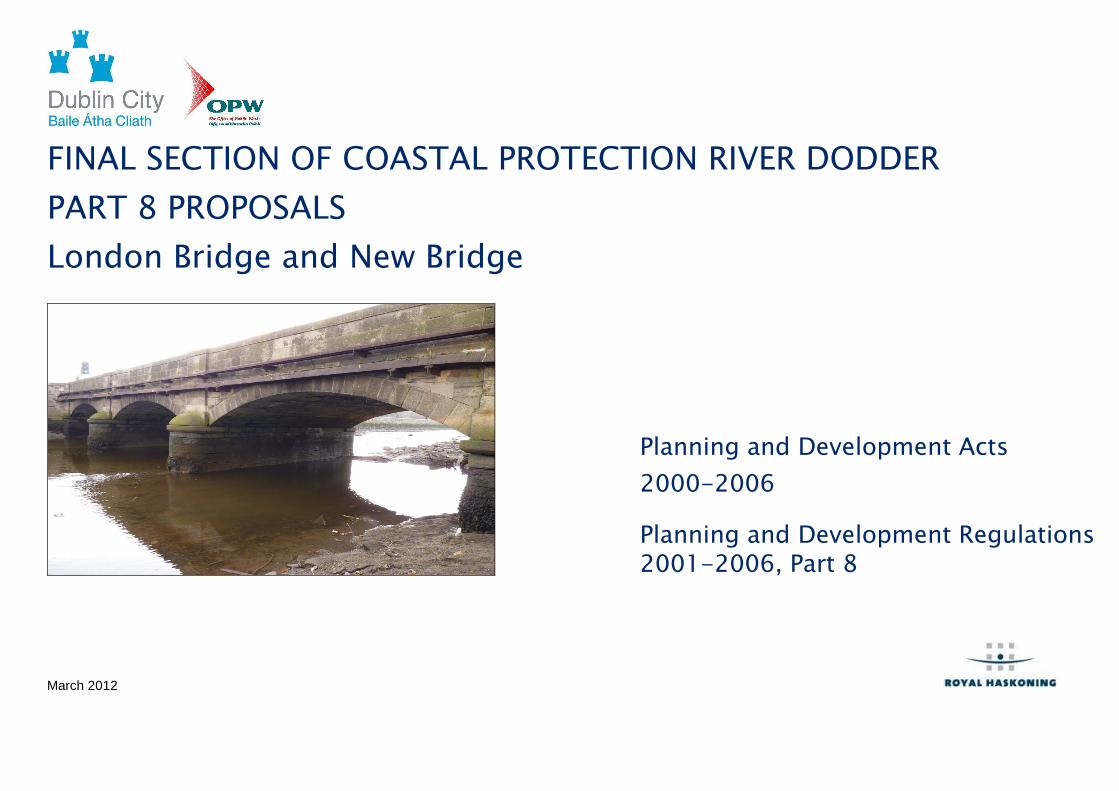
LONDON BRIDGE PREFERRED SOLUTION The preferred solution is as shown in Appendix 2 on the drawing 9S229 / 4206 Option 4B and computer generated image Figure 1. It is the raising of the upstream and downstream parapet to 5.0mMhD, incorporating glass ‘windows’ for the top section of the raised parapets to avoid the loss of panoramas along the river channel by pedestrians crossing the bridge. The raising of the parapet to 5.0mMhD is the required height in order to prevent flooding from a combined fluvial and tidal joint probability 1 in 200 year design event with climate change. This will require the level of the existing parapets to be raised by approximately 720mm. Description London Bridge is a 3 span masonry arch bridge with granite masonry parapets and spandrels, connecting Bath Avenue with Londonbridge Road. It was constructed in 1857. The spans are 7.15m, 7.44m and 7.15m. The footways are generally 2m wide and the bridge has single way traffic operated by traffic signals. The site investigation identified that the parapets are constructed with a rubble core. Both footways were found to accommodate a significant number of services on both sides of the road including gas, water, HV electricity, telecoms, foul drainage and street lighting (Appendix 1 Figure 2). Because the raised defence is strictly only required to this new level on the upstream face, the construction works needs only to be undertaken on upstream side of the bridge. However, from a visual perspective, it is felt that the same construction on both faces would be more aesthetically pleasing.
Options A number of options were identified as possible methods to provide a heightened parapet. All of the options carry the same need, in terms of minimising disruption to the underground services under the pedestrian footpaths on each side of the bridges and road closures. It should be noted that one of the main electricity feeds into Dublin is accommodated under the footway of London Bridge and so any works which may affect the feed will need to be programmed carefully with the electricity board. Option 1: Do Nothing A Do Nothing approach would mean that the bridge remains unchanged. From a flood defence point of view, the parapets would remain as they are and no works would be undertaken to maintain or raise the parapet structures. With climate change, the river flows and tide levels are expected to increase. Therefore, the defence standard will decrease over time, increasing the risk of flooding and to life, for residents in the adjacent residential areas. The risk of failure/collapse of the parapets under flood water loading and/or due to the impact of debris floating down the river, would remain. When a collapse of a section of the parapet occurred, it would result in flooding of the surrounding area and a temporary closure of the bridge to facilitate the repair of the damage sustained, causing disruption/delay to the local population and road users. The bridge would remain as the weak-link in the chain of the new flood defences along the River Dodder, meaning that flood risk to this part of the City would not be reduced in line with National Standards and the current risk to life from flooding would increase with time. Option 2: Simple Raising of Existing Parapets with Masonry This would involve adding additional courses of granite simply laid on top of the existing parapets. This was quickly found to be unviable because the raised parapet would not have the structural strength to
9S9229 4 Mar 12
sustain the increased loading from the hydrostatic head of water or the impact from any floating debris in the river hitting the bridge, during a higher river flow/flood event. For this reason it was considered an unviable option and not considered further. Option 3 Granite Faced Reinforced Concrete Walls (F ull Concrete Saddle Slab) requiring services to be diverted/rais ed The concrete ‘saddle’ slab consists of a reinforced concrete slab cast over the arches and infill, of the existing structure, beneath the road surfacing. The reinforced concrete saddle would cover the entire plan area of the bridge. The reinforced concrete would be extended to each edge of the bridge to form the foundation of the parapet/flood walls. The flood alleviation works will require the parapets to be raised by approx 720mm. From an aesthetic stand point this approach has the benefit that the reinforced concrete walls could be ‘hidden’ behind granite masonry facing, maintaining the aesthetic appearance of the bridge. The increased strength of the wall’s core will resist both the hydrostatic and the dynamic floating debris loads. This option would result in a corresponding raising of footpaths by more than 150mm in order to maintain views for pedestrians over the parapets, similar to those enjoyed today. Pedestrian railings would need to be provided between the footpaths and roadway, due to the safety issues created by increasing the kerb height, see drawing 9S229 / 4211 Option 3.. The public consultation responses were opposed to such railings. The bridge would need to be closed for some 12 to 18 months to undertake this work.
Another disadvantage is that the reinforced concrete saddle slab would require the diversion of the existing services within the bridge footpaths to allow them to run on top of the new concrete saddle, whilst still being buried below the raised footpath surfacing. Due to the additional significant cost to realign the services and the length of disruption to the services and road traffic for this option, it was not considered further. Option 4A Granite Faced Reinforced Concrete Walls ( Partial Concrete Saddle Slabs) - without Walkway This is based upon the same concept as the concrete saddle, as described in Option 3 above, but there will be four individual narrower ‘saddles’ cast over the two piers and two abutments. The flood alleviation works will require the parapets to be raised by approx 720mm. Without raising the walkway, it makes no allowance for the changed environment, i.e. the higher parapets and loss of view, that the public will experience when crossing the bridge. The construction of the concrete saddles will require the closing of the bridge to traffic, but for a shorter period than Option 3, as there will be no need to divert the services. Illustrations of this option are shown in Appendix 2 on the drawing 9S229 / 4203 Option 4A and computer generated image Figure 2. Option 4A(i) Granite Faced Reinforced Concrete Wall s - with Walkway on Riverside Face(s) of Bridge Parapet (suggested through public consultation) This modification to the option was suggested by members of the public at the consultation event. The idea of this is to allow pedestians to walk outside of the raised parapet on a specially constructed walkway on the upstream side of the bridge, in order to maintain views
9S9229 5 Mar 12
of the river. This would require a gap to be created through the recently constructed/raised flood wall at each end of the bridge, to allow pedestrian access to the walkway These gaps in the flood defences would require flood gates, normally left open, that would be closed following the receipt of a flood warning to close off these flood routes. An indicative illustration of this option is shown in Appendix 2 in the computer generated image Figure 3. It is considered that this modification to Option 4A has a number of disadvatges:
• expensive; as the new footbridge(s) would be needed in addition to the flood defence improvement works to London Bridge itself
• this new footbridge would change the character of the area • creates a higher risk of flooding to local residents, if one or
both of the flood gates were accidently left open during a flood event.
• requires scarce manpower following a flood warning to close gates, with any operation difficulties leading to increased risk of flooding.
Option 4B Granite Faced Reinforced Concrete Walls with Upper Glazed Parapet. This is based upon the same concept as the concrete saddles in Option 4, with the slab only being cast over the piers and abutments. As in Option 4A the flood alleviation works will require the parapets to be raised by approx 700mm. The overall height of the new parapets would be approximately 1.75m above the footpaths. However, this option would incorporate a 0.55m high glazed units along the top of the granite faced walls above a height of 1.2m across the whole of the bridge. The windows within the glazing units are made of layers of glass and resin, and are designed to withstand both hydrostatic and impact loads of floating objects carried by the flood flow. The frames
holding the glass panels are resin anchored to the new bridge parapet. If, in the unlikely event of any glass panel being damaged, a replacement would be fitted in a timely manner by the Office of Public Works. Illustrations of this option are shown in Appendix 2 on the drawing 9S229 / 4206 Option 4B and computer generated image Figure 1. Option 4C: Granite Faced Reinforced Concrete Walls with Upper Demountable Emergency Parapet This solution is exactly the same as Option 4B except that the glazed panels would be replaced with demountable ‘emergency’ metal columns and beams 0.55m high, deployed on the granite faced bridge parapets when a flood warning was issued. The demountable units would be stored near the entrance to the old pumping station on the Londonbridge Road side of the Dodder estuary. It has been estimated that once manpower and equipment were present on site it would take approximately 2 hours to deploy the demountable defences. It is anticipated that these defences will need to be deployed on an increasingly frequent basis in the future, due to climate change. There would need to be regular training / trial deployments to ensure operational competence to deploy the defences when a flood warning is issued. While this section of the river estuary is predominately at risk from tidal flooding there is also a significant fluvial flood risk element. The main downside with this proposal is that, outside normal working hours, it estimated that it will take some six hours to call men into the Drainage Depot in Marrowbone Lane, mobilise them out to site and for them to complete installing/closing all of all gates and demountable flood defences in the area (2 hours for this defence alone). If a
9S9229 6 Mar 12
minimum six hour flood warning is not received, then flooding may occur to properties in the London Bridge area. Cut backs in Dublin City Council manpower, already reduced by 25% on peak values, are due to reduce by a further 6% in the next 3 years, plus another 10% in the next 8 years. The presence of new demountable/emergency flood defences upstream will also draw on limited manpower during all future flood events. Illustrations of this option are shown in Appendix 2 on the drawing 9S229 / 4210 Option 4C and computer generated image Figure 4. Option 5: Bridge Widening (raised through consultat ion process) Through the public consultation process the idea of a completely new but wider bridge was suggested. This would be the most expensive option considered, at some 10 to 15 times the cost of the other options. There would be insufficient economic justification (i.e. insufficient increased benefit) based on reducing flood risk. For this reason this option was not considered further. Option 6: Flood Gates/ Demountable Barriers Across The Road at Each End of the Bridge (raised by OPW) Under this option the river would be allowed to flood onto the bridge above the level of the existing parapets, with any flood water contained between the two sets of flood barriers, one at each end of the bridge. Each flood barrier would be some 2.2m high and 8m long. The advantage of this approach is that in normal day to day operations the bridge environment would remain as it is now, with the gates / barrier usually in their open position, allowing pedestrians and vehicles to use the bridge enjoying the river views. The disadvantages of this option are very similar to that of Option 4C, in terms of the closing of the gates / installing the demountable barriers, following the issuing of
a flood warning. However, in the case of this option, the closing of the gates / installing the demountable barriers would take considerably more time to erect and disassemble, and require considerably more manpower at a time of emergency. In addition, this option would require closing of the bridge to all traffic following the issuing of a flood warning i.e. in conditions when the water level has been forecast to exceed the existing parapet level, even if no flood eventually occurred. It is to be anticipated that bridge closures would occur on an increasingly frequent basis in the future, due to climate change. Collapse of the existing bridge parapets is also likely with this option during a large flood event. As with Option 1, should / when a collapse of a section of the parapet occurs, it would result in a temporary closure of the bridge to facilitate the repair of the damage sustained, causing disruption/delay to the local population. A greater risk of utility service outages would also result from such a collapse.’ An illustration of a demountable barrier option is shown in Appendix 2 on the computer generated image Figure 5. Recommendation Option 4B, Granite Faced Reinforced Concrete Walls with Upper Glazed Parapet , with the parapets raised on both the upstream and downstream sides of the bridge. This option provides the most economic, sustainable, aesthetically pleasing and least disruptive scheme and is, therefore, the recommended option.
9S9229 7 Mar 12
NEW BRIDGE
PREFERRED SOLUTION The preferred solution is as shown in Appendix 3 on the drawing 9S229 / 4103 Option 4. It is the raising of the upstream and downstream parapets to 5.22mMhD, in order to prevent flooding from a combined fluvial and tidal joint probability 1 in 200 year design event, including an allowance for climate change. This will require the parapets to be raised by approximately 0.3m or to be at least 1.2m above the walkway. Raising the parapets to at least 1.2m above the walkway also provides an opportunity to satisfy the health and safety requirements for the top level of the parapets; the existing parapet height is considered substandard, i.e. too low. Description New Bridge is a 3 span masonry arch bridge with granite masonry parapets and spandrels, connecting Lansdowne Road with Herbert Road. The spans are all approx 6.2m. The footways are approx between 1.2 to 1.8m wide. The bridge has two way traffic working. The site investigation identified that the parapets are constructed of solid granite block masonry. The footways were found to be filled with services on both sides similar to the findings at London Bridge (Appendix 1 Figure 2). The flood alleviation works will require the parapets to be raised by approximately 300mm or to be at least 1200mm above the existing back of path levels to satisfy the health and safety requirements as indicated above.
Options A number of options were identified as possible methods to provide a heightened parapet. All of the options carry the same need, in terms of minimising disruption to underground services under the pedestrian footpaths on each side of the bridges and road closures. Option 1: Do Nothing A Do Nothing approach would mean that the bridge remains unchanged. From a flood defence point of view, the parapets would remain as they are and no works would be undertaken to maintain or raise the parapet structures. With climate change, the river flows and tide levels are expected to increase. Therefore, the defence standard will decrease over time, increasing the risk of flooding and to life, for residents in the adjacent residential areas. The risk of failure/collapse of the parapets under flood water loading and/or due to the impact of debris floating down the river, would remain. When a collapse of a section of the parapet occured, it would result in flooding of the surrounding area and a temporary closure of the bridge to facilitate the repair of the damage sustained, causing disruption/delay to the local population and road users. The bridge would remain as the weak-link in the chain of the new flood defences along the River Dodder, meaning that flood risk to this part of the City would not be reduced in line with National Standards and the current risk to life from flooding would increase with time. Option 2: Simple Raising of Existing Parapets with Masonry . This would involve adding additional courses of masonry simply laid on top of the existing parapets, as was considered for London Bridge. This was quickly found to be unviable because the raised parapet would not have the structural strength to sustain the increased loading from the hydrostatic head of water or the impact from any floating
9S9229 8 Mar 12
debris in the river hitting the bridge, during a higher river flow/flood event. For this reason it was considered an unviable option and not considered further. Option 3 Granite Faced Reinforced Concrete Walls (F ull Concrete Saddle Slab) The concrete saddle slab consists of a reinforced concrete slab cast over the fill and arches, beneath the road surfacing of the existing structure, as considered for London Bridge, Option 3. The reinforced concrete saddle would cover the entire plan area of the bridge. Since the existing masonry parapets are relatively thin, and therefore, there is insufficient structural width to construct a parapet with a reinforced concrete wall core and with granite facings, whilst maintaining the full width of the current footpaths, the saddle will be constructed slightly wider than the existing bridge to form the foundation of the parapet walls. However, due to the reduced depth of the fill above the arches and the shallower arch construction, compared to London Bridge, there is insufficient ‘depth’ for this option to be constructed over the arches without extensive regrading of the road levels to the approaches on both sides of the bridge. As the footways are full of buried services, even if they could be diverted during construction, there would not be space to relocate them within the bridge structure and maintain the current road levels. There are two principal issues with this option, one being the temporary closure of the bridge, causing major disruption to the traffic during the construction period and secondly the significant cost of accommodating the many services below the bridge surface causing major regrading works to the section of road approaching the bridge. For these reasons it is not considered a viable option.
Some detail of this option is shown in Appendix 3 on the drawing 9S229 4104 Option 3. Option 4 Granite Faced Reinforced Concrete Walls (Partial Concrete Saddle Slabs) This is based upon the same concept as the concrete saddle, as described in Option 2 above, but there will be four individual narrower ‘saddles’ cast over the two piers and two abutments. This will remove the need to divert the services and provide considerable cost and time savings compared with Option 3. The slab’s normal steel reinforcing bars will be substituted with the use of rolled steel sections (e.g. steel ‘I’ beams), with concrete cast around the beams. These four reinforced concrete slab areas will be the foundation for the parapet walls on each side of the bridge. The new sections of the parapet walls between the slab areas will span horizontally between the adjacent sections of the parapet connected to the four slabs. The existing granite parapet walls and copings will be removed, stored and cut as necessary, so that they can be used as cladding to the new concrete parapets. This will preserve the appearance of the existing bridge. The increased strength of the wall’s core will resist both the hydrostatic and the dynamic floating debris loads. The construction of the concrete slabs will require the closing of the bridge to traffic, but for a significantly shorter period than Option 3, as there will be no need to divert the services. Details of this option are shown in Appendix 3 on the drawing 9S229 4103 Option 4. Option 5 Post tensioned masonry parapet To allow the raising of the existing masonry parapets and to overcome their structural inadequacy without some strengthening/reinforcement, this option, to ‘post tension’ the parapets, was developed. This will provide a way to provide additional structural strength without increasing the width of the parapets.
Final Section of Coastal Protection River Dodder - London and New Bridges Part 8 Proposals
9S9229 9 Mar 12
The coping stones would be removed, and the existing parapets would be raised as necessary with masonry blocks, to achieve the designed flood defence level. Then holes would be drilled/cored vertically through the existing granite masonry to the underside of the arches. Some of these holes would be very long and there would be the risk of causing damage to some of the facing and arch span masonry, particularly if it is in a poor condition. A continuous horizontal ‘spreader’ beam would be accommodated within the top course of masonry blocks, below the coping of the raised parapet. Over the three arches, threaded stainless steel bars would be installed in each hole together with washers, spreader plates, nuts at each end. The top nut of each bar would be tightened to provide the post tensioning to the system. A disadvantage of this post tensioned system is that an alternative anchoring system would be needed where the parapets pass across the two piers and abutments. Another disadvantage of this option is that extensive drilling through granite masonry will be required, with problems being encountered in any existing areas of poor quality masonry. Extra maintenance would also be required in checking and re-tensioning, as necessary, the stainless steel bars. For these reasons it is not considered a viable option. Recommendation Option 4 Granite Faced Reinforced Concrete Walls (P artial Concrete Saddle Slabs), with the parapets raised on both the upstream and downstream sides of the bridge. This option provides the most economic, sustainable, aesthetically pleasing and least disruptive scheme and is, therefore, the recommended option.
TEMPORARY WORKS The solutions and recommended option described above for each bridge will require temporary works. These works will include:
• Bridge closures and traffic signalling works and diversions over some period of time.
• Temporary works at the bridges within the river will be designed to accommodate flood flows and be easily retractable.
9S9229 10 Mar 12
ENVIRONMENTAL REPORT AND PROPOSED MITIGATION MEASURES
Dublin City Council Law Agent has advised that no E nvironmental Impact Statement is legally required for this work. However, there were two specific environmental issues envisaged with the preferred options concerning both bridges, the aesthetic impact that the raised parapets would cause and the disruption caused to road users, including pedestrians, during the construction phase. The aesthetic impact was considered from two points of view; firstly from viewing the bridges when looking in the direction of the road alignment and secondly for the pedestrians being able to continue to enjoy the views from the bridge of the river itself. This issue applies in the main to London Bridge, where the parapets are being raised by some 700mm (2ft 6ins). As indicated in the previous sections, even though the defences are strictly only required to the new levels on the upstream faces of each of the bridges, the parapet on the downstream faces could remain unaltered with the same parapet crest levels. However, from a visual perspective it was felt that symmetry of parapet heights on both faces would be more aesthetically pleasing. For the pedestrians, being able to continue to enjoy the panoramas of the river from the footpaths on London Bridge is important. The selection of the preferred option which utilises glazed panels for the upper portion of the raised parapets enables the views to be maintained. Regarding the disruption to the bridge users, whether local or from a greater distance, it is recommended that the works to the bridges are carried out sequentially rather than concurrently, to minimise the disruption, principally to the local population. Those travelling into this
area of the city can be diverted away from the bridge that is temporarily closed from some distance away, thereby minimising any disruption to their journeys. Standard environmental considerations will be adhered to during construction in order to minimise noise and air pollution, risk to utilities, prevent river pollution and minimise all disruption. Appendix 4 Archaeological Report – Margaret Gowen & Co Ltd Summary: There is reference to two recorded sites of archaeological interest along the stretch of the Dodder from London Bridge to Ball’s Bridge as the location of early crossing points of the river.. One of these sites is at New Bridge. This site is contained within the Dublin City Development Plan 1999 as a Documented Archaeological Site. The report considered it unlikely that any archaeological features have survived, however it recommends that proposed works to New Bridge should be carried out in consultation with Duchas, the Heritage Service and Dublin City Council. In addition the River Dodder is an area of conservation as scheduled in the Dublin City Development Plan 1999. Any work at both bridges should therefore be carried out with due regard to the specific character of the area, with where feasible, original masonry walls retained. The preferred options comply with this requirement in their design and this should include for any granite capstones removed during construction to be retained and reused. Any finds or remains discovered during works shall be notified immediately to the City Archaeologist and the contractor must make provision for and fund whatever archaeological work is needed on site if remains are noted.
Final Section of Coastal Protection River Dodder – London & New Bridges Part 8 Proposals
9S9229 11 Mar 12
RIVER DODDER MANAGEMENT PLAN The structural works will be maintained by the OPW.
RIVER DODDER CFRAM STUDY The River Dodder Catchment Flood Risk Assessment and Management Study (CFRAMS) is due to be published in 2012. This study and associated flood mapping is part of the works required to comply with the EU Floods Directive. It is premature to pre-empt the findings of this report in advance of its publication and completion.
CONCLUSION All proposed works are on DCC owned land. Consultation has taken place with the general public. Information meetings took place with the South East Area Committee and major stakeholders. The risk of flooding cannot be fully reduced to National Standards until this final phase of flood defence works at London Bridge and New Bridges is completed. Dublin City Council Law Agent has advised that no Environmental Impact Statement is legally required for this work. The preferred scheme for both London Bridge and New Bridge, which is the most socially and environmentally beneficial, has clearly been identified. Nothing of environmental significance will be lost and all works will be monitored and validated by independent consultants. Great care has been taken to identify any environmental issues and appropriate mitigation measures are proposed as part of the construction. It is the recommendation to the City Council to proceed with this scheme as proposed.