33


Warrnambool City Council 2
Structure Plan Warrnambool Eastern Activity Precinct
Table of Contents. 1. The Project. 3 1.1 What is the Warrnambool Eastern Activity Precinct? 3 1.2 Why is Warrnambool’s East Changing? 3 2. The Plan. 5 2.1 Built Form & Scale 7 2.2 Transport & Movement 9 2.3 Landscape & Environment 11 3 Key Features of the Plan 13 3.1 Built Form and Scale 13 3.2 Access and Movement 19 3.3 Landscape and Environment 25 4. Progressing the Plan. 29
Table of Figures 1. The Study Area 2. The Structure Plan 3. Built Form and Scale 4. Access & Movement 5. Landscape & Environment 6. Staging/ Implementation Appendix 1: Road Reserve Cross Sections

Warrnambool City Council 3
Structure Plan Warrnambool Eastern Activity Precinct
1. The Project In June 2004, Warrnambool City Council engaged Hansen Partnership and Hyder Consulting to undertake a Structure Plan for the area defined as the ‘Warrnambool Eastern Activity Precinct’ at the eastern extent of Warrnambool. The need for the Eastern Activity Precinct Structure Plan was highlighted as one of the key recommendations of the Panel Hearing in relation to Warrnambool Planning Scheme Amendments C28, C31 and C32, which sought to rezone Residential and Rural land to Business Use. The Panel noted that integration between various forms commercial and residential development within the Precinct was a primary objective and that should ‘prepare a Structure Plan for the Wider Gateway Plaza Precinct, as a matter of urgency’ (p.85). As defined in the project brief, the aim of the project is to ‘develop a Structure Plan to guide the integrated development of the Warrnambool Eastern Activity Precinct. The Plan will guide the major changes in land use, built form and public spaces that together will achieve economic, social and environmental objectives for the Precinct for over a 20 year period The project was initiated and funded by the Warrnambool City Council and engaged with all key land owners and stakeholders within the Eastern Activity Precinct through site visits and a series of interactive planning and design workshops held in June and July 2004.
1.1 What is the Warrnambool Eastern Activity Precinct? Warrnambool Eastern Activity Precinct is the name given to an existing business and rural area on the eastern edge of Warrnambool that has been defined in the Warrnambool Planning Scheme and related Warrnambool Land Use Strategy (2004) as a rapidly growing part of the City, poised to experience a great deal of mixed residential and business development over the next decade. The Warrnambool Eastern Activity Precinct serves as the City’s secondary retail hub and includes large areas of commercially zoned land housing major retail and bulky goods, as well as complementary residential and tourism related accommodation. The Warrnambool Eastern Activity Precinct is also positioned at the eastern entry to and exit from the City and is a critical contributor to the image of the City. The Precinct is located at the eastern extent of Warrnambool to either side of Raglan Parade (Princes Highway) between Horne/ Mahoneys Road to the east, the Gateway Church to the west, the Hopkins River to the south and Dales Road to the north (refer Figure 1). The Precinct is located some 3km from the Central Activity District (CAD) and is proximate to Deakin University’s Warrnambool Campus.
1.2 Why is Warrnambool’s East Changing? Warrnambool Eastern Activity Precinct has been recognized by Council as a major growth corridor and one of the primary locations for development and consolidation of mixed retail, residential and business uses. While it is primarily open rural land at present, it has experienced significant redevelopment pressure in recent times as a result of both public policy and considerable private sector investment, in particular in relation to major retail and peripheral sales style development and suburban residential subdivision.
Warrnambool’s Existing Entry

Warrnambool City Council 4
Structure Plan Warrnambool Eastern Activity Precinct
Figure 1

Warrnambool City Council 5
Structure Plan Warrnambool Eastern Activity Precinct
2. The Plan The overall vision is to establish the Warrnambool Eastern Activity Precinct as a vital and recognizable mixed use urban extension to the City, comprising integrated retail, business, residential, tourism and recreational facilities that are highly accessible and legible to all users, and configured sensitively around the particular natural and landscape qualities that define the city’s predominantly rural fringe. The key principles that underpin the vision are: 1. To establish Raglan Parade as one of the premier business and activity addresses in Warrnambool and an attractive and recognisable urban
corridor defining the City’s eastern entry. 2. To achieve harmonious integration between individual commercial developments and existing residential fabric and form a clearly delineated urban
edge to the east that communicates a sense of city containment and consolidation. 3. To generate a clear urban form and activity transition across the Precinct that represents a shift in character from the open rural areas to the east
towards a more intense urban focus around the secondary retail core. 4. To use the existing natural and environmental features of the Precinct to advantage in generating distinctive and attractive commercial and
residential settings that are distinguishable from other parts of the City. 5. To achieve an intensity of activity across the Precinct that creates the critical mass of people, facilities and services needed to support the widest
possible range of higher order commercial, community and other uses. 6. To establish a beautiful and highly regarded urban environment in terms of both its landscape setting and its collective built form that demonstrates
innovation and the highest quality in planning and design. 7. To form a clear hierarchy of roads to and throughout the Precinct that will ‘open up’ the area and make it easier for pedestrians, cyclists, cars and
public transport services to move freely. 8. To pursue realistic opportunities to incorporate the principles of environmental sustainability in new commercial, business and residential
development throughout the study area. The key elements of the Structure Plan are summarised in the Warrnambool Eastern Activity Precinct Structure Plan (Figure 2). The subsequent figures summarise the key planning and design components that make up the Plan, including: Figure 3: Built Form & Scale, Figure 4: Access & Movement, Figure 5: Landscape & Environment.

Warrnambool City Council 6
Structure Plan Warrnambool Eastern Activity Precinct
Figure 2

Warrnambool City Council 7
Structure Plan Warrnambool Eastern Activity Precinct
2.1 Built Form & Scale Figure 3 summarizes the proposed built form and scale configuration envisaged for the Warrnambool Eastern Activity Precinct. The key objectives in relation to built form are: § Establish a clear and legible urban pattern that is sensitive to the Precinct’s landform and subdivision pattern. § Create development form that provides a sense of frontage and street address to each frontage. § Generate an urban form that portrays a sensible arrangement of backs to backs and fronts to streets. § Establish development that is diverse and interesting in appearance with clear vertical and horizontal breaks. § Define development form with diverse roof form and silhouette that conceals infrastructure and services. § Achieve a development scale that sits within as opposed to above the natural landscape setting. § Define an urban pattern that communicates a transition between the western retail and the eastern end. § Ensure the highest possible degree of design quality in development form and finish. § Underpin the principles of ESD in the alignment, orientation and design of buildings, streets and places. § Manage the visual setting through the careful control of signage, infrastructure and advertising. These objectives have been achieved through: § Encouraging large format high quality display and sales development fronting the Highway frontage to the eastern edge of the City forming the first
front of urban development on approach to the City from the east. § Incorporating a subtle break in the hard urban form of Raglan Parade in the centre of the Precinct where the topography rises, accomodating for a
more fine grained commercial or tourist accomodation form that allows landscape to permeate. § Developing a more intense and vibrant urban fabric to the western end of the Precinct along Raglan Parade, with traditional retail and service
deveopment of a human scale presenting a high quality frontage to the Highway and other interfaces. § Establishing a clear network of generous format service business, office and/or employment generating use behind the Highway commercial ‘skin’,
which is a recognisable Precinct in its own right and serves as an urban form and activity connector between the east and west. § Creating large areas of standard suburban and medium density residential subdivision configured carefully according to topography to the northern
portion of the Precinct up to Dales Road oriented around a broad centrally located detension/ water body. § Retention and protection of broad areas of rural land located to the east of Horne Road and associated Campus facilities to the east of Mahoney
Road that reiterate the existing open and/or pastoral condition and the clearly delineated urban edge. § Achieveing absolute integration between urban form and activity areas within the Precinct through formulaic building form treatments, including back
to back relationships and a clear built frontages to streets, corners and people places.
Existing Street Frontage

Warrnambool City Council 8
Structure Plan Warrnambool Eastern Activity Precinct
Figure 3

Warrnambool City Council 9
Structure Plan Warrnambool Eastern Activity Precinct
2.2 Transport & Movement Figure 4 summarizes the proposed transport and movement network envisaged for the Warrnambool Eastern Activity Precinct. The key objectives in relation to accessibility are: § Define permeable access through the Precinct in a north-south and east-west manner. § Facilitate integrated and safe pedestrian and cycle connections throughout the Precinct. § Achieve meaningful connections to the east of the existing Gateway Plaza centre. § Achieve appropriately spaced signalized junctions along Princes Highway. § Establish an attractive and inviting Highway arrival experience along the Princes Highway. § Manage surface car parking in ‘courts’ to reduce the visual impact from the Highway. § Establish suitable reserves to peripheral roads such as Horne Road to accommodate for future traffic needs. § Incorporate integrated public transport to ensure that equitable access for all is provided. § Facilitate pedestrian linkages across the Highway to ensure that the route reflects an activity corridor. § Communicate a clear roads and access hierarchy that can be the basis for a new regime of built form. These objectives have been achieved through: § Establishing a clear and legible hierarchy of grid streets extending across the Precinct that connect with existing and proposed roads and activities
that will equitably accommodate for cars, public transport services, pedestrians and cyclists. § Encouraging heavy vehicle and/or through traffic to bypass the Warrnambool City Centre and Eastern Activity Precinct via Hornes Road, lead
northward with the intension to improve the amenity and image of the Raglan Parade corridor to the west of the City entry. § Installation of two new signalised intersections along Raglan Parade in conjunction with the existing intersection at the North-South Road to entice
redevelopment of the Precinct’s north-eastern sector and establish equitable access to activities to either side of the Highway corridor. § Creation of an important new East-West link route that connects Horne Road with the retail core and the North-South Road further west, and in turn
serving as the essential line of transition between core residential subdivision and commercial and business services. § Installation of service road formats to either side of Raglan Parade between signalised intersections to allow for discreet vehicular access to the
commercial frontage and safe access to and from the Highway corridor. § Confirmation of new public transport servicing the total Precinct, including existing and planned residential, commercial and campus areas with the
opportunity of primary stop or interchange facilities associated with the primary retail core to the west. § Integration of dedicated pedestrian and cycle pathways to all roads, encouraging pedestrian links from residential/ business areas to and from the
commercial core and incorporating links across Raglan Parade and further south across the railway towards the Hopkins River trail.
Raglan Parade

Warrnambool City Council 10
Structure Plan Warrnambool Eastern Activity Precinct
Figure 4

Warrnambool City Council 11
Structure Plan Warrnambool Eastern Activity Precinct
2.3 Landscape & Environment Figure 5 summarizes the proposed landscape and environment treatments envisaged for the Warrnambool Eastern Activity Precinct. The key objectives in relation to built form are: § Recognize the role and place of both topography and landscape in the Precinct as key markers. § Protect and enhance local view corridors along the Highway and to north and southern high points. § Aim to retain and/or enhance existing landscape features within the Precinct, including cultural plantings. § Continue the important legacy of landscape associated with the Princes Highway corridor. § Acknowledge the importance of drainage management and servicing of the flat north-east land. § Utilize landscape as the common thread that can help to integrate different land uses and forms. § Adopt the principles of ESD, including Water Sensitive Urban Design in the planning of all places. § Utilize landform and mounding to manage the visual presence of car parking to the Highway frontage. § Encourage strong canopy landscape effects to the northern hillside residential estate for visual integration. § Consider a role for a major water feature/ detention area to the north-eastern flat as a development focus. § Establish proud and useable public open spaces that are highly visible, accessible and north facing. These objectives have been achieved through: § The provision of a network of linked public open spaces which provide for harmonious integration of diverse land uses within the Precinct. § Encouraging the integration of ecological considerations in all aspects of public and private domain landscape treatment, through considerations of
environmentally sustainable and water sensitive urban design. § Recognising and seeking to protect the existing landscape elements which contribute to the environmental character and quality of the Precinct. § Embracing the established desire of Council, through it’s Raglan Parade Streetscape Concept, to transform the Princes Highway into a landscape
boulevard of note, which will reflect a positive image for both the study area and the greater Warrnambool. § Encouraging the coordinated development of streetscape treatments by advocating the preparation of a Public Domain Manual for the Precinct. § Recognising the importance of retaining existing vegetation where this is seen as significant or contributory to the character of the Precinct. § Emphasising the importance of indigenous plant species in new landscape treatments. § Utilising extensive car parking areas as opportunities for extensive canopy tree landscape, with associated amenity and ecological benefits. § Seeking to protect important existing view corridors which contribute to an understanding of the landscape character of the Precinct.
Existing Pastoral Setting

Warrnambool City Council 12
Structure Plan Warrnambool Eastern Activity Precinct
Figure 5

Warrnambool City Council 13
Structure Plan Warrnambool Eastern Activity Precinct
3 Key Features. The key features of the Warrnambool Eastern Activity Precinct Structure Plan as outlined on the Plan represent the initiatives and actions required to achieve the defined Activity Centre objectives. These features are described below and grouped under the categories of Built Form and Scale, Transport and Movement, and Landscape and Environment. Issues associated with dedicated Land Use and/or the supply and demand for Commercial, Retail or Business development are not examined within the Structure Plan, rather these have been clearly defined in the intermediate term through the directions of the Warrnambool Planning Scheme Amendments C28, C31 and C32 Panel Hearing and supported in the preceding Retail and Land Use Studies undertaken by the City. The key features of the Structure Plan focus therefore on the ‘physical’ form and integration of the development across the Precinct, acknowledging that there is due demand and take up of the land for development over a 20 year period. 3.1 Built Form and Scale The following built form and scale initiatives represent the key bases of the Structure Plan and are described below. An outline of the key issues and outcomes of the Structure Plan relating to built form and scale is also included in tabular form at the conclusion of this section. 3.1.1 Urban Form and Sub-Precincts The proposed form of Warrnambool’s Eastern Activity Precinct seeks to draw upon the pre-existing urban patterns occurring within the locality and the anticipated development formats considered and notionally confirmed as part of the C28, C31 and C32 Panel Hearing process. Generally, this comprised low rise detached and consolidated residential formats to the west in transition to open ‘big box’ retail development and associated large format showroom/ sales stock leading eastward towards Glenbeudy Drive. It is anticipated that this rather disparate configuration will be complemented with further and more substantial large format bulky goods and sales buildings towards the key Horne and Mahoneys Road junction with the Highway. In order to achieve greater urban form integration and connectivity between these presently separated development cells, the Structure Plan outlines an extension of urban form along the Highway frontage and extending considerably to the north to establish a continuous urban pattern that evolves around the geometric arrangement of property boundaries, fence lines, windbreaks and unmade roadways. Rather than experiencing the Eastern Activity Precinct as a single urban entity, discreet shifts in urban form and pattern have been applied to ensure that development not only reflects distinctive ‘use’, but also a slightly different sense of place, articulated in building scale, architectural form and public (or private) realm treatments.

Warrnambool City Council 14
Structure Plan Warrnambool Eastern Activity Precinct
The general urban pattern set out in the Structure Plan promotes a relatively tall and setback 2 to 4 storey urban form to the eastern extent of the Precinct, defining the key entry to the City, leading westward along Raglan Parade towards a more fine grained recessive development form set in the foreground of the significant north-south topographical/ landscape break dissecting the Precinct. The urban structure becomes more intense and contained further to the west, where 1 to 3 storey traditional retail formats hedge closer to the Highway frontage and present a lower, but more active profile to the primary spine. An urban form transition occurs to the north, where the scale and format of development diminishes from the larger formats positioned along the critical Highway spine, towards more modest and broadly set office and service business buildings, stepping down finally to an extended residential sector comprising a mix of 1 and 2 storey detached and attached housing. While the proposed urban form is inherently Precinctual, the intension is to encourage integration of uses and activities. This may be realised in many forms across the Precinct, where higher density residential development may abut retail premises and/or where business or office formats integrate successfully tack on or above established shop form. High quality design and architecture that communicate the building’s salient use and activity is a necessary and fundamental factor in ensuring the distinctiveness of the various places within the Eastern Activity Precinct. 3.1.2 Suburban Density Housing Suburban density residential subdivision and development is planned to the north of the Eastern Activity Precinct, extending east of the existing hilltop estate towards Glenbeudy Drive and beyond towards Horne Road south of Dales Road. While the existing estate is located on an elevated position with excellent views to the south, land to the east is less likely to develop immediately as a function of the low lying topography and inherent drainage management issues. The formation of a generous detention basin for management and distribution of drainage will in due course release a significant portion of the northern land for subdivision and redevelopment, accessed from Dales Road to the north or north south extensions off the primary east-west link road. Residential development within this sector should be of 1 and 2 storeys in scale and primarily detached, catering for the considerable demand for housing and accommodation in the north-east of the City. Provision should also be made for higher order of housing, in particular in discreet locations around the proposed water body (size and form to be determined) and adjacent to the retail core, allowing for convenient access to a range of Town Centre facilities. Such housing should be up to 3 storeys in height and may house smaller dwellings with limited external space. Spatial demands may be offset by the benefits of proximity to the high amenity attributes of the water body, retail hub or related parklands.

Warrnambool City Council 15
Structure Plan Warrnambool Eastern Activity Precinct
Development within these new residential sectors should not be ‘gated’, and should be carefully designed with environmental sustainability principles in mind, in particular solar orientation, materials use and water management. Residential development should be strongly aligned to an urban grid defined by local streets and subdivision. Traditional 1970s style cul-de sac development which does not support visual or pedestrian permeability (as has occurred at the existing urban edge) should be avoided. Some residential sectors to the north-west will be located on elevated ground and will be highly visible, requiring modest use of colour and varied roof form. 3.1.3 Medium Density Housing Higher housing densities in the form of medium rise or density housing is identified as an appropriate transition form in the Structure Plan and work well as the medium between existing established residential stock and new or evolving commercial or related development. The need for higher densities of housing is universally accepted in both urban and rural sectors as a function of an ageing population and shifting lifestyle patterns. Demand for such forms of housing may be even greater in the Eastern Activity Precinct due to the location and status of Deakin University to the east. Medium density housing forms as 2 to 3 storey walk-up townhouse, apartment or unit developments are appropriate in such ‘hub’ settings and establish a ‘captive’ market for commercial trade and activity. Proposed medium density housing stock is recommended around the fringe of the Gateway Plaza and proposed Retail form, invariably fronting the key east-west link road and forming an attractive frontage, where a ‘backside’ of development would typically occur. One such example of medium density infill occurs on the lower reaches of the existing hillside residential subdivision dissected by the completed north south road. On approach to the Gateway Plaza, the presentation of higher density 3 storey attached housing reduces the perceived visual impact of the big box retail form and forms a viable medium between otherwise conflicting urban typologies. Other locations for medium density infill occur to the western side of the existing north-south road, integrating with a belt of aged and assisted car housing to the west of the C31 land. Incremental medium density development of 3 storeys is also encouraged to the southern side of the Highway opposite the core retail area. While this is an established residential area, it is likely that change may occur in this area in tandem with the consolidation of retail and business activities. It should ultimately establish as a continuous strip of more consolidated form along the southern side of the Highway to the west of the historic Napthine Residence.

Warrnambool City Council 16
Structure Plan Warrnambool Eastern Activity Precinct
Achieving medium density housing in such new build or established locations will depend on what incentives exist for local developers and land owners. In new residential subdivisions there may be dispensations relating to private open space or car parking that can be seen to entice a higher order of development. Similarly, the consolidation of individual lots on the southern side of the Highway may be rewarded with an ability to increase about a standard 2 storey form. Given the relatively high exposure and the small proportion of medium density housing within the Precinct, it will be imperative to communicate a high quality of design and finish to set a benchmark for further consolidated housing across the City. 3.1.4 Retail and Commercial Significant existing retail buildings occur within the Eastern Activity Precinct and a substantial additional retail floor space has been supported by the independent Panel Hearing in relation to Amendments C28, 31 and 32, leading to a critical mass of retail and sales development in the Precinct’s western sector. New retail development is planned to either side of the proposed north-south road, to the Highway frontage and to the east of the existing Gateway Plaza Shopping Centre, behind the recent Harvey Norman development. New retail development has a responsibility to present itself positively to the external environment, and the imminent growth of residential and business uses in close proximity to existing (and proposed) retail forms demand a significant improvement in the design and presentation of all sides (and the three dimensions) of retail development. Retail development to the west of the proposed north-south road abuts aged and standard suburban housing and should present to both the Highway frontage and the eastern streetscape. A generous buffer should be incorporated to the rear of the retail form to ensure minimal impact on the residential surrounds. This buffer may comprise service access to the rear of fine grained specialty retail facing the east. At least one pedestrian connection should be provided from the existing residential sector through the retail form and further west. The retail form should be no greater than 2 storeys (or 8m) in height and should present glazed and/or highly articulated frontages (and sideages) with a simplified roof form with concealed services. Generous barrier free pedestrian paths and public spaces should be established in front of the proposed form to encourage outdoor activity. Proposed retail format development to the eastern side of the north-south road should be addressed in an integrated manner with the Gateway Plaza. Extensions to the east (C28) should also be no greater than 2 storeys (or 8m) in height and form internal linkages with the existing centre to the west while also presenting an articulate and high quality frontage to the southern Highway elevation and the northern extension of Bescott Street (as either a vehicular or pedestrian outdoor link). Further retail development to the east of the Bescott Street alignment generally should not proceed until the full floor space

Warrnambool City Council 17
Structure Plan Warrnambool Eastern Activity Precinct
entitlements on Business zoned land provided under C28 and C31 are realized. When such development is appropriate, it should be configured as a freestanding form, aligned at the junction of the Bescott Street link and the intermediate east-west link, with active frontages to the south and west and a distinctive architectural identity. Smaller freestanding retail forms located close to the Highway frontage, including food outlets or service stations and the like should be of 1 or 2 storeys in scale and present with some consistency to the south in terms of setback, height, parapet and roof form. These buildings should be designed as 4 sided objects as they will be visible from the road corridor and many other aspects. Signage should be integrated into the building form and not be freestanding. 3.1.5 Business and Employment The belt of proposed business and employment development anticipated to extend from around Glenbeudy Drive east towards Horne Road established an excellent opportunity for high quality and innovative business, office and/or technology park style development that is well position in terms of its convenience to retail and residential service and its close proximity to Deakin University. It is a potential hub for research and development and/or service business and should accommodate for substantial floor plate development over between 2 and 3 storeys within a green campus setting. Generous landscaped building setbacks with well concealed car parking (to front but mainly back) and broad glazed frontages will define the sense of place within this corridor, with the northern most buildings enjoying an outlook over the proposed water storage area. The northern portion of the Precinct is accessed from the Highway at three separate points and is also serviced by the east-west aligned link off Horne Road, resulting in a large number of corner sites which are likely to be able to accommodate for increased development scale, feature forms or building entry. Buildings located on such sites should turn the corner and establish a clear sense of address to both streetscapes. The natural pastoral character of the site as present should be respected in the development of this business quarter, which can, due to its inherent openness, permeate the open landscape qualities of the rural fringe. Environmentally sustainable design should also be a primary feature of this Precinct, ensuring that building orientation can take advantage of the solar benefits of the east-west aligned sites. This may have some bearing on the presentation and ‘height’ of buildings within the Precinct, with largely glazed forms stepping from 3 storeys to the primary frontage down to 2 or 1 storey behind to permit natural sun or daylight into the heart of sites. Visual transparency to and through buildings and the Precinct in general should be strongly encouraged. 3.1.6 Peripheral Sales Large format peripheral sales and bulky goods development has been proposed for the eastern junction of Horne/ Mahoneys Road and the Highway, with large singular buildings set deep into lots behind open surface car parking. This format is generally supported in the Structure Plan as directed in the Amendment C32 Panel hearing; however a particularly strong emphasis should be placed in minimizing the visual bulk and presence of the substantial warehouse type building, such as Bunnings which have the capacity to dominate the setting.
Warrnambool City Council 18
Structure Plan Warrnambool Eastern Activity Precinct
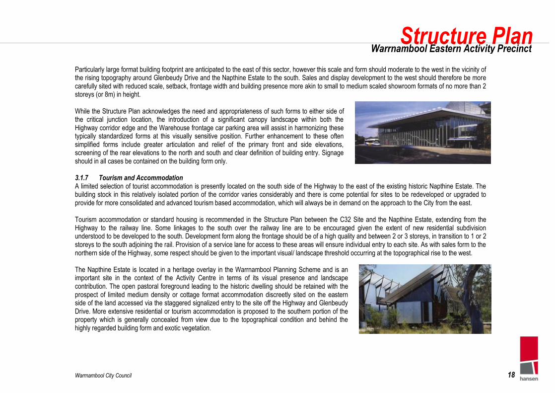
Particularly large format building footprint are anticipated to the east of this sector, however this scale and form should moderate to the west in the vicinity of the rising topography around Glenbeudy Drive and the Napthine Estate to the south. Sales and display development to the west should therefore be more carefully sited with reduced scale, setback, frontage width and building presence more akin to small to medium scaled showroom formats of no more than 2 storeys (or 8m) in height. While the Structure Plan acknowledges the need and appropriateness of such forms to either side of the critical junction location, the introduction of a significant canopy landscape within both the Highway corridor edge and the Warehouse frontage car parking area will assist in harmonizing these typically standardized forms at this visually sensitive position. Further enhancement to these often simplified forms include greater articulation and relief of the primary front and side elevations, screening of the rear elevations to the north and south and clear definition of building entry. Signage should in all cases be contained on the building form only. 3.1.7 Tourism and Accommodation A limited selection of tourist accommodation is presently located on the south side of the Highway to the east of the existing historic Napthine Estate. The building stock in this relatively isolated portion of the corridor varies considerably and there is come potential for sites to be redeveloped or upgraded to provide for more consolidated and advanced tourism based accommodation, which will always be in demand on the approach to the City from the east. Tourism accommodation or standard housing is recommended in the Structure Plan between the C32 Site and the Napthine Estate, extending from the Highway to the railway line. Some linkages to the south over the railway line are to be encouraged given the extent of new residential subdivision understood to be developed to the south. Development form along the frontage should be of a high quality and between 2 or 3 storeys, in transition to 1 or 2 storeys to the south adjoining the rail. Provision of a service lane for access to these areas will ensure individual entry to each site. As with sales form to the northern side of the Highway, some respect should be given to the important visual/ landscape threshold occurring at the topographical rise to the west. The Napthine Estate is located in a heritage overlay in the Warrnambool Planning Scheme and is an important site in the context of the Activity Centre in terms of its visual presence and landscape contribution. The open pastoral foreground leading to the historic dwelling should be retained with the prospect of limited medium density or cottage format accommodation discreetly sited on the eastern side of the land accessed via the staggered signalized entry to the site off the Highway and Glenbeudy Drive. More extensive residential or tourism accommodation is proposed to the southern portion of the property which is generally concealed from view due to the topographical condition and behind the highly regarded building form and exotic vegetation.

Warrnambool City Council 19
Structure Plan Warrnambool Eastern Activity Precinct
3.1.8 Key Action Summary Issue How Who Priority Initiate Retail Development Confirm Rezoning of Amendment Sites Council High Fix Building Form and Scale Parameters Council Policy & Associated Guidelines. Council High Provide Incentives for Medium Density Infill Planning Scheme Provisions & Guidance Council High Precinct Planning and Design Management Establish Precinct Planning Control Team Council, Land Owners High Confirm Future Growth Directions Planning Scheme Provisions Council Medium Precinct Masterplan for Sub Areas Detailed Design Studies Council, Land Owners Medium Development Contributions Plan Discussion between landowners and councils Council, Land Owners Medium
3.2 Access and Movement The following access and movement initiatives represent the key bases of the Structure Plan and are described below. An outline of the key issues and outcomes of the Structure Plan relating to access and movement is also included in tabular form at the conclusion of this section. 3.2.1 Proposed Road Layout and Hierarchy The road layout communicates a clear roads and access hierarchy which facilitates north-south and east-west movements through the Eastern Activity Centre Precinct and connects Gateway Plaza with adjacent residential and commercial land uses. The Structure Plan proposes that this is best served by providing a grid of roads with the Princes Highway to the south, Dales Road to the north, Horne Road to the east and the proposed north–south link to the west forming the respective boundaries. The purpose of the east-west link roads will be to channel traffic within the Precinct to the north-south spine roads of Horne Road, Glenbeudy Drive, and the North-South Link Road which in turn provides controlled access to the Princes Highway. The provision of a full east-west connection through the Precinct will aid internal local movements obviating the need for drivers to use the Princes Highway. The access and movement plan articulates the hierarchy of roads envisaged as follows: A- Arterial Road B- Trunk Collector Road C- Collector Road D- Access Street

Warrnambool City Council 20
Structure Plan Warrnambool Eastern Activity Precinct
Further detailed are provided in Table 1 below: Table 1 – Functional hierarchy of roads in the Eastern Activity Precinct
Road Name Street Type Target Speed1 Bus Route Width* Function East – West Roads Dales Road Collector 50 kph Yes (part of) 12m Local access to Warrnambool East residential areas Connection to
Princes Hwy via Horne Road but not part of proposed by pass. East – West Axis (North/South to Glenbeudy)
Access Street 40kph Yes 7m2
East – West Axis (Glenbeudy to Horne)
Collector 50 kph No 12m
Access between Precinct elements in lieu of Princes Hwy. Service road access to the rear of Gateway Plaza. Access to residential areas to the north. Western end will abut landscape buffer between Paynes land and AMP development
Link Road Access Street 40kph Yes 7m Access to C28 and ancillary development car parks. Secondary egress from Bunnings and adjacent developments to Horne Road
Raglan Parade (Princess Hwy)
Arterial Road 80kph No 6.9-7m Future widening required as per the road reserve sections included in Appendix 1
North – South Roads Horne Road Trunk Collector
widened to AMC4/AMC 5**
60 kph No 7m
Potential medium to long term arterial route catering for heavy vehicle movements. Could form part of an eastern by pass of Warrnambool connecting with Wangoom Road. Future widening required as per the road reserve sections included in Appendix 1
Bunnings Access Road Access Street 40kph No 8m Ingress to Bunnings and adjacent developments Glenbeudy Drive Collector 50 kph Yes (part of) 12m Primary access to central part of Precinct. in lieu of Bescott Street Bescott Street Access Street 40kph Yes (part of) 7m Left in / Left Out or Left Only. Limited access to service station and
C28 car parking areas. Extension northwards along the eastern side of C28 (to connect with the east – west axis) will be incorporated as a “shared surface” with pedestrian and bus priority
North – South Link Road Collector 50 kph Yes See Grogan Richards concept
Primary access to the Gateway Plaza, C31 and the adjacent residential areas in the north west with a through connection to Dales Road. Cross section adjacent to the Gateway Plaza will incorporate landscaping treatments and traffic calming measures to facilitate east – west pedestrian movements (as tabled at the panel hearing)
Source: Warrnambool Planning Scheme 1 Refers to the average traffic speed normally associated with the road classification (and not the posted speed limit) 2Subject to the requirements of bus operation *Assumes two way operation. Excludes footpaths. Maximum width within range should be used when bus use is anticipated. ** From the Draft Victorian Code for the Management of Vehicular Access to Arterial Roads

Warrnambool City Council 21
Structure Plan Warrnambool Eastern Activity Precinct
3.2.2 Princes Highway Intersections The Princes Highway has been classified as an AMC2 – Limited Access Urban Arterial Road by VicRoads. As such its primary function is to cater for the safe and efficient movement of through traffic whilst providing limited access to adjacent land uses through widely spaced controlled intersections and some intermediate minor local connections. Refinements to the Highway Road Reserve are proposed to the fringe that will enhance vehicle maneuverability, safety and allow for safe pedestrian and cycle access (refer section). The proposed hierarchy to maximize the operational efficiency and safety of the road for all road users is as follows: Primary Access Points Traffic generated by development will be accommodated through three major signalized intersections along the Highway, at: § The North / South Link Road, § Glenbeudy Drive, and § Horne Road. The existing signalized intersection to the Gateway Plaza will be modified to incorporate the new North / South Link Road and will provide the primary access to C31, and an enlarged Gateway Plaza. The construction and signalization of Glenbeudy Drive will be triggered as development eventuates and will provide access between Dales Road and Princes Highway. It will also provide access to commercial, retail and residential uses abutting the east – west axis spine road. The signalization of the Horne Road intersection will be triggered by the development of Bunnings to the north and / or the development of the Lascorp site to the south for bulky goods. In the medium to long term, Horne Road may be widened to create an arterial connection to Wangoom Road forming part of an eastern bypass of Warrnambool. Widening should occur to the east of the existing road reserve to accommodate for significant level changes occurring to the north. Alignment to the east will also allow the future road corridor to absorb existing established tree planting as a central roadway median. (sections/ appendix)

Warrnambool City Council 22
Structure Plan Warrnambool Eastern Activity Precinct
Secondary Access Points Secondary accesses to the north of the Princes Highway will be provided at Bescott Street and to access the Bunnings Site. The exact form of the Bescott Street access will be subject to a more detailed examination as development proceeds but will either operate as a left in facility or a left in /left out facility. Access to Bunnings will be limited to left in only with all egress via Horne Road. Secondary access to the Princes Highway south will be limited to left in / left out access to the Lascorps site and to existing and proposed residential areas. Service Roads Service roads are to be provided directly to the east of Glenbeudy Drive to access peripheral sales (to the north) and tourist accommodation (to the south). These will operate as left in / left out facilities with the start and end tapers located so as not to conflict with the primary and secondary access points. 3.2.3 Public Transport Routes and Stop Locations The primary mode of access to the Eastern Activity Centre Precinct will be through the provision of bus services. To make bus use attractive to people traveling to the development, the bus stops will need to be located as close as possible to the buildings that are the final destinations for passengers. Ideally, the walking distance from the bus stop should be less than for the car parks and no more than 400m from the entrances / exits to major attractors. Buildings set back from the bus routes must be linked to it by footpaths that are direct, well surfaced, and well lit. Safe crossing points in the form of zebra crossings should be considered where the development is located on the opposite side of the carriageway from the bus stop. The design of bus routes through the Precinct should be as direct as possible, with no back tracking or excessive extra running time. This is consistent with operator and passenger objectives of providing fast and reliable services that are attractive for passengers. The main demand for bus services within the Precinct is expected to be from the existing Gateway Plaza building, its eastwards extension (C28) and the community facilities abutting the new north – south link. At present the Plaza is served by three bus routes: § Route 4 – Gateway Plaza § Route 6 – East § Route 7 – Sherwood Park (Deakin University) The Structure Plan seeks to expand and extend these services so that public transport is integrated within the Precinct. The following should be explored: § Extending Route 4 northwards from Wanstead Street to McKiernan Road then Dales Rd, North – South Link into the Gateway Plaza and then in an anti
clockwise circuit of Gateway Plaza using North – South Link, Princes Hwy, Bescott Street, East – West axis and then back onto the North – South Link. This will serve the Payne residential subdivision, the new community facilities, C31 and the eastwards extends of the Plaza.

Warrnambool City Council 23
Structure Plan Warrnambool Eastern Activity Precinct
§ Extending Route 6 northwards from Gateway Plaza forming a clockwise route along the North – South Link Road, East – West Axis, Bescott Street, then along the link road to Glenbeudy Drive before returning along the Princes Highway and rejoining the existing route 6 at Selby Road. This will serve the new community facilities, C31, the eastwards extends of the Plaza and retail adjacent to Harvey Norman.
§ Diverting Route 7 to run through the Eastern Precinct to Deakin University and connecting with the proposed rail station for Deakin University. In all cases it is imperative that the extension of Bescott Street along the eastern extension of C28 is designed to accommodate public transport access. As the Precinct develops, consideration should also be given to providing new or diverted services to the new residential areas in the north east. 3.2.4 Pedestrian Linkages A permeable network of pedestrian paths will be provided to integrate the various Precinct elements. The following links are considered to be the most key: § Controlled pedestrian crossing points across the Princes Highway at the major intersection points of Glenbeudy Drive, the North / South Link Road and
Horne Road. § Between Caroline Street/ Wanstead Street residential areas and the Gateway Plaza via the community centre
and to formalize an existing pedestrian desire line. § Pedestrian routes through Gateway Plaza to achieve access between the Plaza and eastern retail extensions. § Along the public open space separating the Payne Subdivision and Gateway Plaza and when access through
the Gateway Plaza cannot be achieved (outside business hours). § Provision of 3 separate crossing points across the North – South Link Road to link C31 with Gateway Plaza. § A pedestrian priority route through the car park linking C28 with Glenbeudy Drive. § Across and around the water body to facilitate recreational walking opportunities. § Bridging of the railway line to link residential developments to the south and north and to provide a continuous
pedestrian path from Mahoneys Road to the Princes Highway (as an alternative to the latter). § Along the East – West Axis road to facilitate pedestrian movements between residential areas to the north
and retail opportunities to the west and south. § Along the northern side of the Princes Highway to facilitate pedestrian movements from Deakin University
extending towards the Gateway Plaza in the west, which will need to be established beyond the Road Reserve in association with landscape treatments.
§ Between bus stops and building entrances including zebra crossings at appropriate locations.
Possible Pedestrian Access across Nth-Sth Road

Warrnambool City Council 24
Structure Plan Warrnambool Eastern Activity Precinct
3.2.5 Railway Line The Victorian government is currently examining the feasibility of providing a station at Deakin University on the Warrnambool to Melbourne railway line which is currently privately operated, but soon to be transferred back to V-Line ownership and management. If constructed the station would offer irregular services to Warrnambool CAD, Melbourne and intervening stations. The provision of a station at Deakin offers the opportunity to provide interchange facilities with bus route 7 through the synchronization of bus timetables with the rail service and potentially widening the public transport catchment area of the Eastern Activity Centre Precinct. The railway line also acts as a potential barrier to cycling and walking. To mitigate the impact on pedestrian and cycle access from the Hopkins River area and to promote an alternative access route for Deakin University students, a pedestrian bridge across the railway line is considered desirable. 3.2.6 Parking Cells Dedicated car parking areas have been defined in the Structure Plan. These areas are located in close proximity to retail/ commercial areas and should wherever possible be designed as ‘courts’, as opposed to broad expanses of parking pavement. The provision of pedestrian priority routes through car park areas is considered key to providing unimpeded access between building entry and exit points and parking cells. The pedestrian priority routes should be established to direct pedestrian movement in an orderly and safe manner along the shortest practicable routes. Designation of these routes may occur through painted line markings, coloured pavements or raised tables which will serve to slow traffic. Service bays should be located away from parking areas where practicable in order to separate truck and pedestrian movements. 3.2.7 Key Action Summary Issue How Who Priority Establish the North - South link road Council / VicRoads negotiate with AMP/ Sherwood Scott Council / VicRoads/AMP/SS High Determine traffic generation for intersection design Commission traffic impact assessment Council / Consultant High Safeguard alignment of Horne Road for future widening Negotiation with Owner or Public Acquisition Overlay Council High Apply developer contributions towards the signalisation Council / VicRoads, and developers to negotiate Council / VicRoads/Developers Medium Construction of internal roads Discussion between landowners and councils Council / Landowners Medium Pedestrian linkages through Gateway Plaza Enter into discussions with AMP Council Medium Ensure adequate provision for buses Enter into discussions with AMP/ Deakin Uni./ Bus Operators Council Medium

Warrnambool City Council 25
Structure Plan Warrnambool Eastern Activity Precinct
3.3 Landscape and Environment The following landscape and environmental initiatives represent the key bases of the Structure Plan and are described below. An outline of the key issues and outcomes of the Structure Plan relating to landscape and environment is also included in tabular form at the conclusion of this section. 3.3.1 Public Open Space The Structure Plan makes provision for a network of public open space evenly distributed throughout the Eastern Activity Precinct. The provision of public open space will contribute to the achievement of a number of the key principles of the Plan, which are described in detail as follows. The public open space area identified on the Plan between the existing Gateway Plaza and residential subdivision to the north (P1) assists in the provision of a harmonious integration of commercial and residential land uses. This park will provide a generous landscape buffer, providing visual and spatial separation between the existing commercial and proposed residential uses. The park will also provide opportunities for passive recreation, as well as linkages to other public open space and community facilities, both within and beyond the Eastern Activity Centre Precinct. In a practical sense, the park provides a ‘low-impact’ means of addressing the topographical constraints imposed by the existing level change between the Gateway Plaza car park and undeveloped land to the north. The public open space area identified on the Plan to the east of the C28 land (P2) is envisaged as an urban plaza space, in contrast to the ‘softer’ landscape treatment proposed for the previous park. This space has the potential to be developed as a ‘town square’, with active retail and commercial frontages on all sides. The plaza will provide a forecourt in association with any future expansion of the Gateway Plaza. Public open space in association with the proposed water body in the north-eastern area of the Precinct (P3) will provide a high quality public park setting as well as an important ecological function as a natural means of stormwater treatment. This park is envisaged as a major visual and recreational feature within the Precinct, with future residential development oriented to maximize views and hence appreciation of this space. The extent of the water body will be determined according to the required volume of storage, with the edges landscaped using primarily indigenous species and in accordance with the principles of Water Sensitive Urban Design. The detailed design of the water body, as well as the means by which it may be integrated with existing and future water storage areas to the north of the Precinct, should be the subject of ongoing discussions with South West Water. The area of public open space identified immediately east of Glenbeudy Drive, and fronting the Princes Highway (P4), is seen as an important element of the ‘entry experience’ which is encountered by travellers along the Princes Highway. This area of land corresponds with a topographical high point and existing mature stands of shelter-belt trees to both sides of the highway, in effect creating a ‘necking’ midway through the Precinct. In association with the proposed future signalization of this intersection, this park will become one of the primary entry points into the Precinct, and as such will require a landscape treatment befitting its prominence.

Warrnambool City Council 26
Structure Plan Warrnambool Eastern Activity Precinct
3.3.2 Boulevards The Princes Highway forms both the primary movement corridor through the Precinct and the primary opportunity for the creation of a boulevard entry into Warrnambool. The existing boulevard landscape treatments along Raglan Street closer to the town centre, comprising impressive avenues of both Araucaria heterophylla (Norfolk Island Pine) and Ficus macrocarpa (Moreton Bay Fig), provide an important landscape reference. Their prominence serves as an important indicator of the impact which landscape boulevard treatments can provide over time. Warrnambool City Council has recently prepared the Raglan Parade Streetscape Concept, which provides for landscape treatments along the Princes Highway (Raglan Parade) from Jubilee Park Road in the east to Rooneys Road in the west, which encompasses the Eastern Activity Centre Precinct. The intention of the Concept Plan is to use locally-sourced species or existing landmark ornamental species to create visual links that will enhance and complement the coastal and rural landscape features that reflect the local environmental characteristics of Warrnambool. The Structure Plan advocates landscape boulevard treatments along the Princes Highway which are consistent with the Raglan Parade Streetscape Concept Plan. The achievement of the landscape boulevard effect to either side of Raglan Parade and in particular to the northern side of the Highway will be determined by the ability to work within and around existing service infrastructure. A setback of some 5m from the Road Reserve into northern properties is recommended to allow for the installation of a continuous pedestrian pathway and consistent canopy boulevard plantings 3.3.3 Streetscapes Streetscape treatments within the Eastern Activity Centre Precinct will reflect the character of adjacent land uses, contribute to the legibility of the hierarchy of proposed roads and provide a key role in the implementation of water-sensitive urban design outcomes. Streetscape treatments will comprise street tree planting, understorey planting, grasses, pedestrian/cycle paths, street furniture and lighting, with the spatial distribution of individual elements designed to reflect the adjacent land use and hence ensure that streetscapes are suited to their surroundings. In this regard, the Structure Plan advocates the preparation of a Public Domain Manual, which would provide detailed guidelines and advice with regard to the composition of appropriate streetscape treatments for residential, commercial, retail and other sub-Precincts within the overall Eastern Activity Centre Precinct. This should be closely aligned with specification of a dedicated service and infrastructure corridor in the road reserve for all underground services. 3.3.4 Existing Vegetation Existing vegetation of significance within the Eastern Activity Centre Precinct is limited to remnant ‘cultural plantings’ in the form of Cupressus macrocarpa (Monterey Cypress) shelter belts adjacent to both Glenbeudy Drive and Horne Road, and a variety of exotic specimen and avenue trees in association with the existing heritage property on the south side of the Princes Highway opposite Glenbeudy Drive.

Warrnambool City Council 27
Structure Plan Warrnambool Eastern Activity Precinct
The Structure Plan advocates the retention and management of existing vegetation which is considered to be significant, either as remnant indigenous vegetation or as other native or exotic vegetation which has a cultural association with Warrnambool’s history, such as the shelter-belt plantings which are reflective of the rural character of the area. Site investigations undertaken as part of the preparation of the Structure Plan did not identify any areas of significant remnant indigenous vegetation. Detailed investigations in association with the preparation of site-specific development applications for future works would be required to confirm the existence (or lack thereof) of significant vegetation. 3.3.5 Proposed Vegetation The Structure Plan advocates a preference for the use of indigenous plant species for all new landscape treatments within the Precinct; however this should not be interpreted as meaning the ‘exclusive’ use of indigenous species, as it is likely that there will be numerous instances where the use of other native or exotic species will be suitable or desirable. Proposed vegetation will comprise street trees, groundcover plants and grasses within typical streetscapes; wetland plant species within drainage swales and proposed water bodies; canopy trees within car parking areas; and a diverse range of predominantly indigenous plant species within public open space areas. 3.3.6 Car Park Landscaping The Structure Plan acknowledges the requirement for extensive car parking areas in association with the forms of development which are proposed within the Precinct. In order to ensure that these car parking areas provide a positive amenity and make a visual contribution to the character of the Precinct, it is intended that all car parking areas be extensively planted with canopy tree species. This is a critical component of the Structure Plan and has the potential to significant enhance the appearance, function and effect of Highway frontage and related commercial development. The intent in this regard is to ensure maximum provision of ‘soft’ landscape with a minimal occupation of space at ground level, hence ensuring that car parking areas are both spatially-efficient and provide a high level of visual quality and user amenity. There are numerous tree species which are suited for this purpose, comprising a range of indigenous, native and exotic trees. Careful consideration and selection of appropriate tree species can also aid the legibility of these car parking areas. 3.3.7 Water Sensitive Urban Design Water sensitive urban design (WSUD) offers an alternative to the traditional ‘conveyance’ approach to stormwater management. It seeks to minimise the extent of impervious surfaces and mitigate changes to the natural water balance, through on-site reuse of water as well as through temporary storage.

Warrnambool City Council 28
Structure Plan Warrnambool Eastern Activity Precinct
An integrated approach to stormwater management is the key to water sensitive urban design. The integrated approach regards stormwater as a resource rather than a burden and considers all aspects of run-off within a development, including environmental, social and cultural issues. The key benefits available include the protection of environmental values and supporting wildlife habitats, filtration of stormwater, recreational opportunities and the protection of development from flooding. Water sensitive urban design is envisaged as being integrated into many aspects of the Structure Plan, including local public open space networks, building layout, road layout, streetscape layout and design, parking area storage and on-site detention for large sites. In combination with the creation of a large water body / detention storage area in the north-eastern part of the Precinct, the Structure Plan will provide numerous measures to ensure that future water flows leaving the Precinct are of a consistently higher quality than those entering the Precinct. 3.3.8 View Protection The Structure Plan acknowledges the need to provide protection for a number of existing prominent vistas and view corridors within and adjacent to the Precinct. These include views south to the existing residential areas from the elevated northern parts of the Precinct, corridor views along the Princes Highway, the prominent tree cover in association with the elevated land adjacent to Glenbeudy Drive, views towards the heritage estate and sweeping views across the entire Precinct which are obtained on approach from the west. View protection is seen as being an important contributor to the recognition and protection of the existing positive aspects of the landscape character of the Precinct. It will be obtained through ensuring that development proposals give due regard to the identified vistas when determining appropriate building height, scale, form and orientation. 3.3.9 Key Action Summary Issue How Who Priority Protect existing landscape character Planning Scheme Policy/ Guidelines Council High Confirm detention need for water management Undertake a hydrological modelling Council High Manage treatment of site- stormwater Implement WSUD Principles in Planning Scheme Council High Establish Princes Highway boulevard Implement the existing Raglan Parade Streetscape Concept Council High Increase the canopy vegetation cover to site Planning Scheme Policy requiring high quality landscape treatments Council Medium Protect significant trees Planning Scheme Policy requiring protection of significant trees. Council Medium Establish public domain character for Precincts Prepare a Public Domain Manual Council Medium Development contributions: drainage management Prepare Development Contributions Plan Council Medium

Warrnambool City Council 29
Structure Plan Warrnambool Eastern Activity Precinct
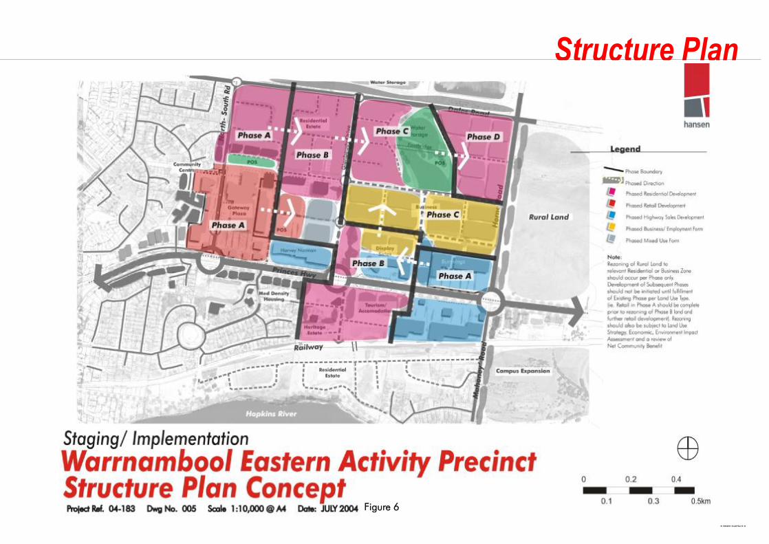
4. Progressing the Plan The vision for the study area will require the cooperative effort of the Warrnambool City Council and all major stakeholders. In particular the vision will not be achieved without the support of local land owners including Bunnings, Lascorp, the Patterson (Sherwood Scott) and Drake Families, Timerate and AMP Capital Investors (owners of the Gateway Plaza). The achievement of the vision will also be reliant upon the support of State Government agencies responsible for roads, public transport, water, drainage and other infrastructure. An initial action will be to gain the support of stakeholders for the concepts advanced in the Structure Plan. While the concepts have been developed in consultation with these parties, formal stakeholder commitment to the project would be preferred. Similarly, an ongoing commitment to the implementation of the Plan over the medium to long term is required from Council. Such an ongoing commitment from Council may be reinforced by means such as: § Establishing a long term management group or team with the responsibility of implementing the Structure Plan recommendation; § Incorporating the recommendations of the Plan by way of Scheme policies and rezoning beyond that confirmed in C28, 31 and 32 Panel hearings, § Establishing the necessary mechanisms/ processes to collect funds for capital or infrastructure works, including development contribution plans, and § Identifying immediate actions and priority projects that Council can initiate or commit to annual budgets. The first steps to give weight to the vision outlined in the Structure Plan is for Council to formally adopt it. New Policies and Zonings, which give effect to the principles and objectives of the Plan are also recommended, which can support the ‘staged’ rezoning of the Precinct’s remaining rural land according to key infrastructure and development ‘triggers’. The format of staged implementation is summarised in Figure 6. A new Planning Scheme amendment will include a: § new sub-clause to the Municipal Strategic Statement (MSS) specifically addressing the objectives of the Warrnambool Eastern Activity Precinct
Structure Plan and its staged rezoning and land release. The MSS should acknowledge the key triggers for future land release/ rezoning and require clear demonstration of ‘need and suitability’ through a retail and land use strategy and assessment of community benefit and environmental impact.
§ new Overlays, which incorporates the Structure Plan Concept into the Local Planning Policy Framework as a Development Plan Overlay (DPO) and gives the confidence and surety of development form without the inflexibility of a fixed Incorporated Plan Overlay (IPO).
There may also be a basis for a new Local Policy in the Planning Scheme that outlines the planning and design matters that applicants should consider in the development of the Precinct, including more detailed guidelines related to building design, access networks and landscape treatments as described in this report. The Warrnambool Eastern Activity Centre Structure Plan Report should be incorporated as a referenced document to the Local Policy.
Warrnambool City Council 30
Structure Plan Warrnambool Eastern Activity Precinct
Figure 6

Warrnambool City Council 31
Structure Plan Warrnambool Eastern Activity Precinct
Funding Strategy A funding strategy should be confirmed early in the implementation process. The role of the funding strategy will be to identify sources from which funds will be derived. Elements of the funding equation are likely to include the following: § Council Funding from General Rates - The ability of Council to fund public works from general rates may be limited by budgetary constraints and a
general lack of funds for major capital works projects. However, in order to demonstrate its commitment to civic improvements in the Precinct, Council should provide some funds from general revenue. This could be either for specific projects, or on a dollar for dollar basis (or some other proportion) to match funds derived from other sources.
§ State Government Funds - The State Government makes funds available to local government for public works and urban improvements. This document will provide strong strategic justification to support applications to the State Government for project funds as they become available.
§ Special Charges - The levying of a special charge is appropriate to generate funds where a benefit will be derived by existing property owners and businesses. A special charge to cover the cost of enhancement works within the study area would be an option for generating funds for works, in situation where existing property owners and businesses benefit. A special charge could also be levied to cover the administrative and operational costs of any implementation team established to implement the Plan.
§ Development Contributions - Development contributions are appropriate to be sought from new development where that development will generate a need for the upgrading of infrastructure or public facilities. A Development Contributions Plan would need to be prepared and a development contributions overlay would need to be applied to the study area to enable contributions to be sought. For this to occur:
- a fully costed plan for upgrading works would be required; - the portion of the cost allocated to new development would need to be clearly identified and justified; - the source of all other funds would need to be identified; and - a commitment would be required from Council that the funds collected will be used to implement the upgrading works planned.
Immediate Actions The momentum of the Structure Planning process should also be maintained through the implementation of a series of high priority actions, some of which are outlined in Part 3 of this document. Key actions identified include: § Exhibit and adopt draft Structure Plan for stakeholder and public comment prior to formal Planning Scheme Amendment, § Secure formal agreement with AMP and Sherwood Scott for the North South Road prior to rezoning § Construct the proposed North South Road as a matter of priority § Facilitate rezoning of business land according to recommendation of Panel, § Initiate Retail Development associated with the Patterson Land and AMP’s Gateway Plaza Development, § Initiate Bulky Goods/ Highway Sales type development to the eastern fringe as outlined by Bunnings and LasCorp,

Warrnambool City Council 32
Structure Plan Warrnambool Eastern Activity Precinct
§ Undertake detailed drainage and stormwater detention need for water management in north-east sector, § Undertake detailed traffic studies to determine traffic generation and its impact on intersection design at the Highway, § Undertake negotiations and/or measures to ensure reservation of land to north of Princes Highway for pathways and landscape, § Undertake negotiations and/or measures to ensure reservation of land to the east side of Horne Road for future widening/ duplication, § Confirm triggers for further commercial or residential rezoning of land to in the Precinct, beyond that confirmed by the Panel, § Incorporate incentives and dispensations for land consolidation and medium density housing, § Establish Princes Highway boulevard treatments in keeping Council’s landscape strategy, § Prepare Precinct Plans for defined concept areas as outlined in Parts 3.1 of the Structure Plan § Complete Development Contributions Plan, § Develop Infrastructure Strategy, § Prepare Funding Strategy.

Warrnambool City Council 33
Structure Plan Warrnambool Eastern Activity Precinct
Appendix 1: Road Reserve Sections


