Fire Hazard Risk and Response Capacity Assessment in Aftermath of Kathmandu Valley Earthquake Goldsmith, Evan University of Oregon Geological Sciences Academic Director: Pratt-Sitaula, Beth Project Advisor: Jiba Raj Pokharel Patan, Nepal Submitted in Partial Fulfillment of the Requirements for Nepal: Geoscience in the Himalaya, SIT Study Abroad Summer 2013
Transcript
Fire Hazard Risk and Response Capacity Assessment in Aftermath of Kathmandu Valley Earthquake
Goldsmith, EvanUniversity of OregonGeological Sciences
Patan, NepalSubmitted in Partial Fulfillment of the Requirements for Nepal: Geoscience
in the Himalaya, SIT Study Abroad Summer 2013
Abstract
The Patan area in the Kathmandu Valley could be at great risk for widespread fire hazard in the aftermath of the next large earthquake. Until this risk is properly assessed, response plans cannot be developed. To make an assessment of this risk, case studies, interviews, and field observations will be made. These methods will provide information on the susceptibility of Patan to a fire post-earthquake and to the degree of which the Lalitpur Fire Brigade and local communities are prepared for such a hazard. The objectives are to make a risk assessment for the area through two detailed area studies, be able to provide useful information regarding the current capacity of fire response, and to propose a plan for capacity development.
Disaster Management, Development Studies, Other Earth Sciences
Introduction
Tectonically, Nepal lies within a highly active seismic zone as the Indian plate
collides with and shallowly subducts beneath the Eurasian plate, resulting in the
Himalayan mountain range and 92 active faults that cross Nepal (Nepal, 2011). Nepal has
a history of damaging earthquakes, which includes 1 major earthquake (magnitude 8 or
greater) and 10 significant earthquakes (magnitude 6 or greater) occurring in the last
century (NSET, 2013). This proposes a problem for the Kathmandu Valley, as
geologically it is a shallow basin comprised of soft lake sediment. These sediments pose
risk of wave amplification and liquefaction in the valley, which result in greater ground
movement and infrastructure damage.
In 1911 the first Nepal population census was conducted, yielding results of 5.6
million inhabitants (Government of Nepal, Ministry of Health and Population Division,
2011). In 2010, the population of Nepal had grown to 28 million, and by 2025, a
projected 35.7 million (Government of Nepal, Ministry of Health and Population
Division, 2011). Once, the three royal kingdoms of Kathmandu, Patan, and Bhaktapur
were spatially separated within the valley, however, with population growing at a rate of
1.9% (Government of Nepal, Ministry of Health and Population Division, 2011) the
kingdoms are increasingly merging into each other, a cause for concern of increased
hazard-related damage within the shallow pre-existing lake basin. Patan, just south of
Kathmandu and west of Bhaktapur, is the second largest of the three kingdoms that lie in
the valley and is the third largest city in Nepal (City of Patan, 2013). A study of the
susceptibility of this area to earthquakes and hazardous subsequent effects, such as fires,
could greatly benefit civil administrations and the people of Nepal. The findings of such a
risk and response capacity assessment could be further projected to the Kathmandu
Valley and can be used to greater prepare Patan and the valley for fire hazards in the
aftermath of large (greater than 8.0) earthquakes.
Figure 1. Liquefaction hazard map of Kathmandu Valley Floor Area, representing the risk that soft lake sediments cause for the area. The district of Lalitpur, of which Patan belongs to, is at lower risk of liquefaction than Kathmandu or Bhaktapur.
The best, although still limited, documented major earthquake in Nepal’s history
is the 1934 Bihar-Nepal earthquake. Studying this event through the Memoirs of the
Geological Survey of India, no mentions of fire occurrences post-earthquake were made,
however, it is important to consider that Nepal’s societal circumstances have changed
since 1934. Studies of this particular event will not contribute to the overall assessment of
Patans’ risk and response capacities, but will suggest what potential risks and
characteristics can be expected from the next great earthquake. For example, the
magnitude 8.4 earthquake caused damage to 60% of buildings in the valley and killed
4,300 people (JICA, Ministry of Home Affairs, 2001). Some of the recorded effects were
emissions of sand and water from fissures and damage to transportation facilities,
building and urban structures, electric power supply facilities, water supply and sewage
facilities, and telecommunications facilities. Consequences of the earthquake not
mentioned were the instances of fires and the overall damage and/or deaths the resulting
fires caused alone. In the 1939 account of the 1934 earthquake, fire was possibly
overlooked as a secondary effect of earthquakes as there were no gas containers for
cooking in each residence and there were not widespread power lines and transformers.
These necessary factors for fire ignitions post-earthquake are now relevant to Kathmandu
Valley’s society as a majority of households in the valley have on average two propane or
kerosene containers for cooking (JICA, Ministry of Home Affairs, 2001) and use
electricity.
These developments in society make the possibility of fires occurring post-
earthquake relevant, however, it seems that the Kathmandu Valley has underestimated
the potential risk and damage widespread fire could cause. Initial and preliminary
research has suggested that fire brigades are less concerned about fire hazard after
earthquakes than they are about consequences of the earthquake alone (JICA, Ministry of
Home Affairs, 2002). Since fire was not a major factor in the overall damage of the 1934
Bahir-Nepal earthquake, the public and concerned institutions may not be prepared for
fire hazard as a secondary earthquake effect. However, not only has the occurrence of gas
and electricity usage increased since 1934, an increased population represents greater
numbers of housing and congestion in the valley. With the recent (past 80 years)
developments the valley has undergone, potential for fire hazard post-earthquake has
increased; the preparedness and response capacity of the Kathmandu Valley should
reflect these advancements.
In 2001, the Japan International Cooperation Agency (JICA) and the Nepal
Ministry of Home Affairs recommended that proper mitigation and funding be outlined
within a government stated, national five-year plan to firmly establish mitigation
measures to protect various facilities listed in their assessment. These continuing national
five-year plans (JICA, Ministry of Home Affairs, 2001), need to be updated to include
future proposals and funding for increasing the capability of Kathmandu Valley’s fire
brigades so that they are at capacity to respond to a widespread fire post-earthquake. In
order to make plans sufficient to fit potential needs, three different research questions
must be answered. The first is what is the possibility of widespread fire instances in the
occurrence of a major earthquake? The second being is the operational capacity of the
Lalitpur fire brigade capable of responding to widespread fire throughout the Patan area
after an earthquake? The third is what other plans by the local community have been
established to handle these possible fire instances if they occur? The assessments made
will better establish whether or not Patan, and Kathmandu valley as a whole, have the
need to be prepared for an instance of widespread fire hazard post-earthquake, and in
case of a fire occurrence, how prepared is the area to respond?
Methods
In order to answer these research questions and make a proper assessment of the
fire hazard risk and response capacity of Patan, literary reviews, interviews, and two
detailed area studies were conducted. To answer the first research question, a case study
of one of the largest and most destructive fire disasters post-earthquake in recent history,
the Kobe, Japan earthquake, was made in order to evaluate the factors in which caused
the fires to be so widespread and devastating. Once these main factors have been
recognized, comparisons between Kobe and Patan can be made in areas such as
electricity facilities, building typologies, road width, and gas capacities to determine the
likelihood of a similar fire occurrence post-earthquake in Patan. To answer the second
research question, inquiries as to the current capacity of the fire brigade in terms of
manpower, material, and money (Pokharel, 2013) were investigated. These 3 M’s are
crucial to determining the aptitude of the brigade and any future plans they may have in
handling fire hazards within their jurisdiction. To answer the third research question,
interviews with community tole offices, local municipalities, disaster relief committees
were made.
In addition to the above research protocol, two detailed area studies were
conducted to determine the level of risk for the small areas (20 to 50 houses), and then
this assessment was projected to the general Patan area. This projection is based upon the
combination of the detailed area studies, determined capacity of fire brigade, and
assessment of fire-damaged building comparisons from case study.
Under advisement of Dr. Jiba Raj Pokharel of Tribhuvan University Department
of Disaster Studies and along with graduate student Salouna Staphit, who has chosen her
masters thesis on fire hazard in the aftermath of earthquake, these methods were
constructed and performed. Additionally, prior to field study, research protocol such as
interview questions were reviewed and approved by the SIT Local Human Subjects
review board.
Memoirs of the Geological Survey of India Vol. 73 (1939), and The Study on
Earthquake Disaster Mitigation in the Kathmandu Valley Vol I and II (2001 and 2002
respectively) were used to determine likely consequences from major earthquakes in this
region. The latter volumes also give insight into the expected fire hazard and
corresponding capacity of the valley to handle a fire of this expectation. Reading
materials from the Lalitpur fire brigade, the Lalitpur Fire Station Present Scenario and
Patan Durbar Area Fire Service Strength Reinforcement Plan allowed a multitude of
questions (Appendix A) regarding the response capacity and future plans of the brigade
to be answered.
Interviews held with the President of the Hakha Tole in Mangal Bazar, staff of the
Red Cross Lalitpur district, and official of the Lalitpur Sub-Metropolitan city were useful
in gaining information on the preparedness and local perceived risk of fire hazard post-
earthquake in the area. These respective groups were able to provide a sense of the
community-level preparedness and planning for fire hazard both before and after a large
earthquake.
A Patan ward map from the Lalitpur Sub-Metropolitan city office gave further
information of the division of Lalitpur county and from there decisions were made about
where to focus field observations. Wards six and twelve covering the Mangal Bazar and
Gwarko areas of Patan consist of old, traditional, Newari wooden and brick structures
and new construction with reinforced cement walls, respectively.
Figure 2. Ward Map for Lalitpur District, with wards twelve and six outlined in red. These wards are the locations for detailed area studies. Ward twelve is the top left and ward six is the bottom right section. Ward twelve contains the Mangal Bazar and a large amount of traditional wooden and brick homes with narrow (less than 2m) alleyways. Ward six contains the Gwarko neighborhood which is made up of newer construction buildings with reinforced cement and wider roads (~4m).
The two detailed area studies were conducted assessing the width of streets and
alleys (accessibility), density of housing, positions of transformers and electrical wiring,
building typologies and construction materials, and locations of local water sources.
These field observations helped determine the level of risk for the small areas, which then
allowed a general risk projection to be made for Patan.
Parameters Significances Methods
Alley and Road Width The width of alleys and roads within the selected study areas will dictate how accessible the potential at-risk areas are to the fire brigade and response organizations. The width of these alleys and roads also can indicate how easily a fire could spread from developments across the way.
Measure and classify width of alleys and roads, set into classifications: 0-4m, 4-6m, 6-8m, 8-12m, 14-16m.
Housing Density The congestion of housing, especially depending on the building typologies, can indicate how easily a fire could spread from one house to the next.
Make observations based upon alley and road width and amount of houses within singular courtyards.
Electrical Facilities and Positioning
Although the electrical wattage in Nepal is relatively weak, positioning of electrical wires and transformers can suggest a certain level of hazard i.e. wiring being fed through wooden eaves or transformers being attached to wooden poles.
Make observations of the placements of electrical wires and transformers, the surrounding materials, and how electricity is supplied to residences.
Building Typologies and Construction Materials
Reinforced concrete, brick masonry, adobe and stone buildings with mud jointing, and timber buildings will react differently to ignition and spread of fire. Identifying the primary construction materials for the buildings in each study area will denote the risk potential for fire.
Observe construction-in-progress and note building materials and their relationships.
Local Water Source The proximity to a large and dependable water source is crucial to the response effort and extinguishing capacity of the local community and fire brigade. If these water sources are inadequate or unreliable the ability to effectively put out fires are greatly diminished.
Note distances and availability to water sources such as hitis and inar, wells and traditional community water spots, respectively.
Table 1.
Certain challenges present in the research and field study processes were
translations from Nepali to English, in both literature and interviews, and difficulties of
obtaining pertinent information from the metropolitan offices and response organizations
within the allotted time. Many concepts in the Lalitpur Fire Station Present Scenario and
Patan Durbar Area Fire Service Strength Reinforcement Plan were difficult to evaluate
due to misunderstandings of the English language. Interviews were held exclusively in
Nepali, and while transcriptions were made, not having knowledge of the language or
understanding the conversations as they were happening was problematic. The Lalitpur
Sub-Metropolitan office was not able to finalize their data collected for the Vulnerability
Capacity Assessment for each ward, nor had the Lalitpur District Red Cross finished their
Disaster Risk Response plan, an awareness plan dedicated to earthquake safety. These
community-based preparations of risk assessment and capacity would have been highly
relevant to this study, however, the lack of information readily available through
community organizations were mitigated through the literary reviews and field studies.
Results and Interpretations
The results to this study can best be categorized into both the research question
the information answers and by what method the information was obtained.
Research Question One: What is the possibility of widespread fire instances in the
occurrence of a major earthquake?
The main methods of research in obtaining results for this question were literary
reviews, Kobe case study, and field studies. In 1995, a 7.4 earthquake occurred near
Kobe, Japan. Many houses collapsed and infrastructures thought to be earthquake-proof
were proved inadequate. 35,000 people were injured and 316,000 were left homeless. A
large secondary effect of the earthquake was widespread fire due to ruptured underground
gas lines. This posed a problem for Japan as most of their housing is timber and
neighborhoods are dense. Fire spread very easily under these circumstances, and were not
controlled due to the fact that the fire response teams were unable to reach the affected
areas. The only reason the fires were extinguished was due to fire response boats
projecting water from the sea (Kobe Earthquake). The situation in Nepal reflects some of
these factors, such as dense neighborhoods and wooden housings, however, there is no
large source of water for Nepal to rely on such as the Pacific Ocean. Nepal also does not
have gas lines in the roads that would be in danger of rupturing during an earthquake.
The situation in Nepal cannot be compared to the secondary effects of the Kobe
earthquake, as Japanese society in 1995 is entirely different than the current society of
Nepal. For this reason, the case study does not elude to the potential risk for the
Kathmandu Valley as previously speculated.
In The Study on Earthquake Disaster Mitigation in the Kathmandu Valley Vol. I,
JICA along with the Nepal Ministry of Home Affairs created an earthquake scenario of
which they named the Mid-Nepal earthquake. This earthquake would be of magnitude 8.0
and would be set on the seismic gap in Nepal (JICA, Ministry of Home Affairs, 2001).
According to this potential scenario JICA and the Ministry of Home Affairs did not seem
concerned about fire hazard post-earthquake, “Fire broke out in tons of places, most did
not spread due to the primarily inflammable building materials”. In an opposite
viewpoint, Patan Darbar Area Fire Service Strength Reinforcement Plan explains, “…
Nepal is similar to Japan; an earthquake country and Kathmandu valley has faced many
big earthquakes. So the risk of fire accident caused by earthquake is so high”. There are
multiple points of debate within these resources of how concerned the valley should be
about fire spread ability and fire ignition within the valley post-earthquake. The
following tables explain the estimated damage to residential buildings, fire stations, water
supply pipelines, and electricity power supply lines.
Scenario Earthquake Heavily Partly TotalMid-Nepal Earthquake 53,465 (20.9%) 74,941 (29.2%) 128,406 (50.1%)Table 2. Estimated Damage to Residential Buildings (JICA, Ministry of Home Affairs, 2001).
Scenario Earthquake Heavily Partly TotalMid-Nepal Earthquake 8% 37% 45% Table 3. Estimated Damage to Fire Stations (JICA, Ministry of Home Affairs, 2001).
Scenario Earthquake Damage PointsMid-Nepal Earthquake 588Table 4. Estimated Damage to Water Supply Pipelines (JICA, Ministry of Home Affairs, 2001).
Scenario Earthquake Damage Length (km)Mid-Nepal Earthquake 6.2Table 5. Estimated Damage of Electric Power Supply Lines (JICA, Ministry of Home Affairs, 2001).
Building typologies within the area are mainly reinforced concrete new
construction, or brick masonry with wooden structures (Lalitpur Sub-Metropolitan City,
JICA). Multiple studies (JICA, Ministry of Home Affairs, 2001; Lalitpur Sub-
Metropolitan City, JICA) also suggested that many, if not all, residences within the area
store two weeks supply of tanked cooking fuel at a time, usually near wooden structures.
(Lalitpur Sub-Metropolitan City, JICA) attests to the vulnerability of traditional homes,
especially within the Mangal Bazar area,
“…inside of the buildings such as staircase, partition, beam and column are consisted of almost wood and also window and door facing outside are also wood… All materials in opening or eaves on exterior wall are wood and such part has high risk to cause fire spread easily from neighbor building fire… Usually most weak points of the wooden building is back of eaves and the gap of wall and eaves, and it causes sucking draft and
such sucking draft sucks the fire inside of building”. (Lalitpur Sub-Metropolitan City, JICA)
In regard to newer construction, “In 1st case unification between brick and concrete can
be made but in the 2nd case brick wall will collapse down during earthquake if joint
method isn’t used between brick and concrete frame, and the fire will enter from the gap
of concrete and brick in case of fire” (Lalitpur Sub-Metropolitan City, JICA). Another
quantified risk potential from The Study on Earthquake Disaster Mitigation in the
Kathmandu Valley was fire outbreaks from gas stations.
Figure 3. Fire Outbreak Rank by Petrol/ Gas Station- Mid Nepal Earthquake (JICA, Ministry of Home Affairs, 2001). The outbreak rank is determined by probability of occurrence. ‘A’ being highly probable, and ‘C’ being not very probable. Both ‘B’ and ‘No Petrol/Gas Station’ appear both white here and in book, making it difficult to determine moderate risk from no risk.
Another major factor in the ability for fire to spread is road and alley width
between housing. Patan Durbar Area Fire Service Strength Reinforcement Plan found
that only road widths greater than 12 meters could effectively prevent the spreading of
fire.
Figure 4. Relation Between Width of Road and the Ratio of the Spread of Fire (JICA, Ministry of Home Affairs, 2001).
All areas within their study of the World Heritage area, including and around ward
twelve Mangal Bazar, had road widths of less than 7 meters, meaning fire would not be
stopped by road width.
In the field, positioning of electrical wires, road width, construction materials and
building typologies, location of local water source, and housing density were observed
and recorded in the following tables.
Ward Twelve ObservationsPositioning of Electrical Wires Power lines were often positioned and run
through wooden eaves of traditional Newari roofing. Transformer boxes were mostly secured to metal posts but were placed in either open areas next to wooden temples or placed in narrow alleyways near wooden window and doorframes. Some posts which upheld transformers or unorganized masses of electrical wires were unstable and leaning.
Road and Alley Widths Most alleys measured to be less than 2m wide and most roads were measured at less than 4m wide. Brick and wooden structures walled many of these roads. The occasional main road measured in the 4-6m range.
Construction Materials and Building Typologies The buildings were predominantly traditional style; brick masonry with wooden eaves, stairs, windows, doors, beams, and partitions.
Location of Local Water Source Many inar, wells, are located within the study area. 5 were observed, although the quantity of water within the wells is uncertain. One hiti,
communal water pools, is located in Durbar Square. 1,000 to 5,000-liter water tanks are often placed near inar. A water station with five large water tanks of undeterminable volume (possibly 5,000 liters), spigots, and hoses is stationed in a community square. The fence leading to the spigots and hoses is chained and locked.
Housing Density The housing in ward twelve is extremely dense, the number of four story houses within one courtyard could often be as high as eighteen. Narrow alleys 0-4m wide connected these dense residential courtyards and there are no detached or semi-detached houses.
Table 6. Field observations recorded for study of ward twelve, Mangal Bazar area.
Ward Six ObservationsPositioning of Electrical Wires Electrical wires were often posted on wooden
posts, sometimes joined with metal posts. These posts were mainly at corners of 4m width roads. The two transformers observed were located near exposed wooden construction and near open public area. These wires often ran along houses of reinforced concrete, but were positioned right above wooden windowpanes or doorways.
Road and Alley Widths Road widths were greater than in ward twelve. Most residential roads were around 3-4m in width, while main roads were up to 8m wide. The narrow residential roads were often walled with brick or reinforced concrete.
Construction Materials and Building Typologies A larger percentage of the housing is of reinforced concrete and brick. However, wooden eaves as floors and wall partitions are still used and a classic style of wooden Newari window and doorframes are popular for contemporary homes.
Location of Local Water Source 1,000-liter water tanks are positioned in most, but not all, courtyards. Only two inar were observed for the whole area and one hiti far from study area existed.
Housing Density Most homes are attached or semi-detached. The houses are larger and in most cases not as tall. Up to thirteen houses sharing one courtyard. Less dense than ward twelve.
Table 7. Field observations recorded for study of ward six, Gwarko neighborhood.
These results can be interpreted in multiple ways. According to (JICA, Ministry
of Home Affairs, 2001) there is not a high risk for fire as the construction materials, brick
and concrete, in both traditional and newer construction do not burn. However, (Lalitpur
Sub-Metropolitan City, JICA) suggests that these construction materials are not built to
code and will collapse or crumble during an earthquake. If these materials fail during
ground movement and expose flammable materials it is entirely possible for fire to spread
across the 1-6m road and alleys in both wards twelve and six. The electrical wires
observed during field study were often positioned near wooden structures, especially in
community squares near wooden temples or Newari housing with wooden eaves.
Although the electrical current in Nepal is not dependable and relatively weak, the
possibility of fire due to downed transformers and circuited electrical lines is possible. A
more likely scenario is the combustion of gas tanks within residences during ground
movement; the ignition of fire from this possibility can easily spread through wooden
rafters and eaves to the attached neighboring house. If the magnitude of the earthquake is
large enough to cause 50% damage to residential buildings (JICA, Ministry of Home
Affairs, 2001) then it seems that the possibility of widespread fire due to ignition of
interior fires and outward exposure of flammable materials is very likely. Ward Twelve is
at higher risk of widespread fire post-earthquake than Ward Six as the area has denser
housing, more wooden structures, and narrower alleys and roads.
Research Question Two: Is the operational capacity of the Lalitpur fire brigade capable
of responding to widespread fire throughout the Patan area after an earthquake?
Methods used to best answer this research question were literary reviews and field
study, as the Lalitpur Fire Brigade did not give an interview. They did, however, provide
the Lalitpur Fire Station Present Scenario and the Patan Durbar Area Fire Service
Strength Reinforcement Plan, which answered most prepared questions (Appendix A).
Answers to these questions found within readings are numbered below.
1. Yes, there is possibility for fire occurrence and spreading post-earthquake, however, more concern lies with primary earthquake effects such as building collapse than fires.
2. First response is the Tata Fire Engine (3500L) with one driver and three firefighters. Second response to same incident if necessary is Isuzu Fire Engine (2000L) with one driver and three firefighters.
3. No different plans of action were found.4. Fire Record for 2006-2010
2010- 21 fires within Lalitpur2009- 46 fires within Lalitpur2008- 65 fires within Lalitpur2007- 57 fires within Lalitpur2006- 63 fires within Lalitpur
5. The Lalitpur Fire Brigade has a staff of fourteen, twelve of whom are over 40 years old. This is not an adequate amount of manpower for widespread fire.
6. No information on training/education for firefighting, pre and post-earthquake was found, however, minimum requirements to be a firefighter were listed. These requirements are: 1) Minimum SLC level educational background 2) Height at least 5’ Chest at least 40” 3) Ability to read and speak general English 4) General knowledge of fire engine.
7. Two fire engines, 3500L and 2000L, two carbon dioxide extinguishers, ten dry powder fire extinguishers, thirty foam fire extinguishers, two semi rigid reel hose, three fire hose reel with semi rigid hose, one small firefighting pump, twenty-one delivery hose coupling, five handle-held branch pipe, one carbon dioxide high pressure cylinders, and five end suction fire pumps. However, “almost all the fire fighting equipments are obsolete and not in working condition” (Lalitpur Fire Brigade). The types and quantity of equipment necessary to respond to widespread fires are either not listed or clear.
8. Listed in question 8 are equipments for extinguishing fire chemically.9. Inar (Wells), Hiti, and the Pokhari Pond are potential water sources within Patan.
The water source that fills the fire engines is the Bhainsepati VDC and Mahankal Kathmandu. A reservoir tank of 20,000L still needs to be constructed.
10. There is one fire brigade for all of Patan. There are plans to have three sub-stations in Kwalakhel, Lagankhel, and Balkumari.
11. Not answered.12. Fire hydrants do exist, although it is unclear how many there are or in what
condition they are in.
In addition to the fire brigade itself having an inadequate supply of equipment and
manpower, the resource of which should be available to them on-site, namely water, is
low. Investigations by the Lalitpur Fire Brigade were performed to check each location of
Inar, Hiti, and Pokhari Pond for “water level, water tank, seasonal situation and
maintenance organization” (JICA, Ministry of Home Affairs, 2001).
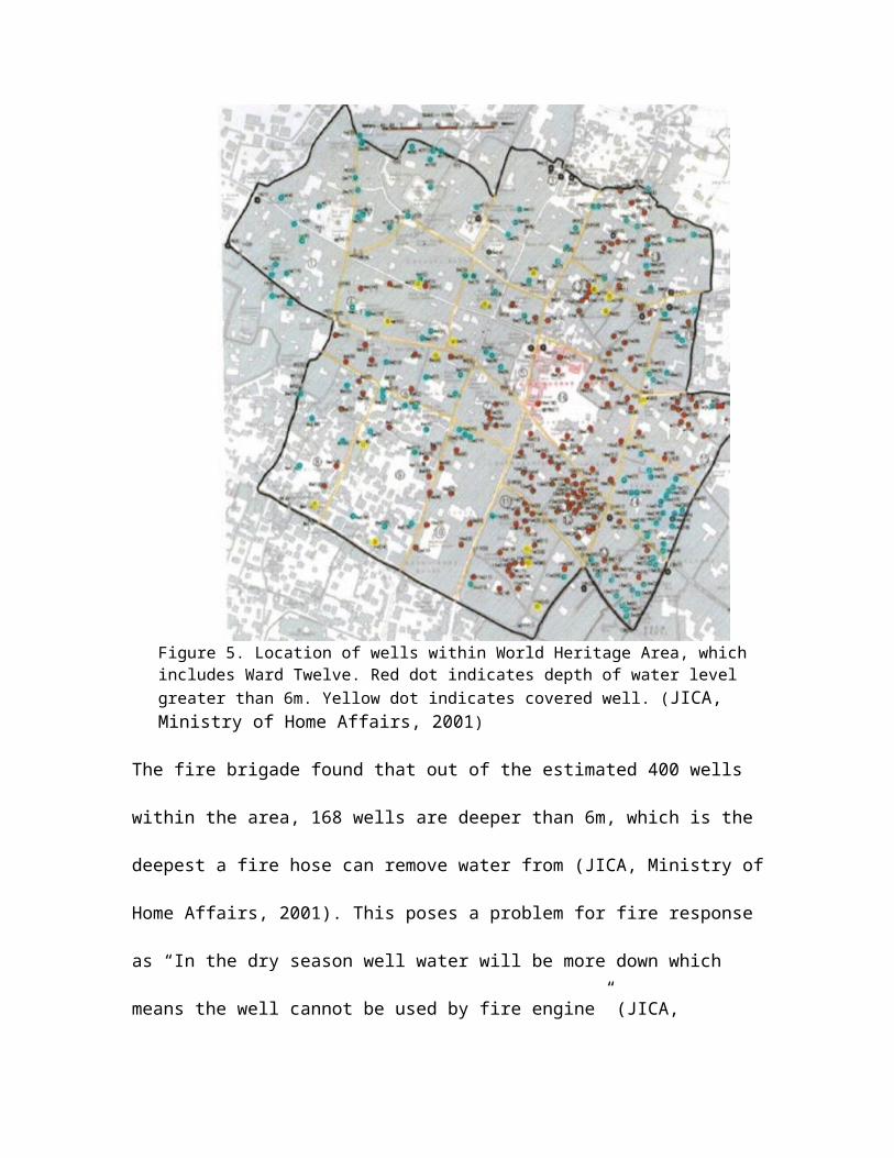
Figure 5. Location of wells within World Heritage Area, which includes Ward Twelve. Red dot indicates depth of water level greater than 6m. Yellow dot indicates covered well. (JICA, Ministry of Home Affairs, 2001)
The fire brigade found that out of the estimated 400 wells within the area, 168 wells are
deeper than 6m, which is the deepest a fire hose can remove water from (JICA, Ministry
of Home Affairs, 2001). This poses a problem for fire response as “In the dry season well
water will be more down which means the well cannot be used by fire engine” (JICA,
Ministry of Home Affairs, 2001). The additional use of Hiti is also not supplementary
enough as the water supply is insufficient, especially during dry seasons. It is found
within the Disaster Risk Management for the Historic City of Patan, Nepal that, “… the
biggest water supply Hiti has only 4L/sec an such water doesn’t store in Hiti and water
store vessel is only 10cm depth” (JICA, Ministry of Home Affairs, 2001). The minimum
amount of water per second necessary for a fire hose is 8.3L (JICA, Ministry of Home
Affairs, 2001). The Pokhari Pond also doesn’t possess the proper amount of water or
dependability for a potential water source for the Lalitpur Fire Brigade to rely on it.
During the dry seasons the pond dries, and is not refilled until the next monsoon.
Not only does the shortage of water sources provide a major problem for the
Lalitpur Fire Brigade, but also accessibility to areas in need of response could prove to be
impossible. The width of alleys and roads within both wards would prove difficult for fire
engines even in normal circumstances, additionally, according to The Study on
Earthquake Disaster Mitigation in the Kathmandu Valley Vol. I, “Serious problems were
that buildings along roads and highways collapsed onto the roadway and blocked access
at many places, especially in the recently developed core and commercial areas” (JICA,
Ministry of Home Affairs, 2001). In Ward Twelve, it would be impossible for fire
engines and possibly even small firefighting pumps to access courtyards (up to twenty
houses) through 1.5-3 meter alleys. In Ward Six, the passable roadways could easily
become impassible due to new construction collapse causing road blockage.
These results infer that the Lalitpur Fire Brigade is not functioning at capacity to
respond to or extinguish widespread fire, either pre or post-earthquake. They lack the
necessary equipment, funding, manpower, and resources to accomplish such a goal. The
three potential water sources Inar, Hiti, and the Pokhari Pond cannot be counted on as
reliable resources for fires. This means that the only local resource for extinguishing fire
would be the community drinking water, which is already scarce and would leave the
community without any drinking water. This is under the assumption that the local water
tanks would withstand ground movement, but this also cannot be relied upon. Most alleys
and roads within Wards Twelve and Six are barely passable for a fire engine initially,
however, with buildings being built not to code and the certainty of roadblock post-
earthquake, many areas within the study will not be accessible. These external factors
even greater inhibit the Lalitpur Fire Brigade’s response capabilities.
Research Question Three: What other plans by the local community have been
established to handle these possible fire instances if they occur?
In order to obtain information in response to this question, answers to interview
questions with Hakha Tole President, Red Cross staff, and official of Lalitpur Sub-
Metropolitan were combined. The questions and their responses are categorized in the
following table.
Questions ResponsesWhat are the preparedness techniques that the community has been following to prevent from fire hazard?
Red Cross Staff- Committee Action for Disaster Response is a training program which involves teaching community members how to use a fire extinguisher or develop a bucket brigade.
Which organizations (government or private) are involved and how are their interventions helping the community prevent fire hazard?
President of Hakha Tole- The Lalitpur Municipality office in coordination with the Red Cross has given the tole one fire extinguisher. The city provides water to households on alternate days for only 2-4 hours, otherwise the 250 families within this tole depend on water tanks of which they pay for.Lalitpur Sub-Metropolitan Official- JICA proposed a detailed master plan for Patan core area.
What is the role of Lalitpur Sub- Red Cross Staff- Alongside the Red Cross,
Metropolitan office in terms of fire safety? Is there any strategic plan to address the fire after a major earthquake?
the Lalitpur Sub-Metropolitan office conducted Vulnerability Capacity Assessments (VCA) for each ward based upon Nepal Government guidelines. The VCA will allow preparedness plans for all types of disasters to be made.
What are the techniques of preparedness other than rescue training that should be provided to locals? Which organization takes charge of this program?
President of Hakha Tole- With the coordination of the Lalitpur Municipal office, trainings regarding rescue operations during earthquakes are provided.Red Cross Staff- Along with local ward offices, awareness programs regarding earthquake safety (pre, during, and post), first-aid training, and rescue techniques are available to locals. The Red Cross Community Based Disaster Risk Response will be formed within wards to administer first aid and rescue at time of disaster. Training will be given to 1 in 100 locals as a dedicated disaster responder. Formation of the Community Disaster Management Committee will address disaster at the community level. The chairman of the ward will be the Secretary of the CDC and political leaders will also be involved.
What is the level of preparedness of the community in case of fire?
President of Hakha Tole- Community members are aware of fire hazard, but are more concerned about building collapse during earthquake. Community is not prepared for widespread fires.
Table 8.
The Study on Earthquake Disaster Mitigation in the Kathmandu Valley makes
clear the steps of which need to be completed in order for local communities to
effectively prepare for disasters of all types. These three steps are as follows;
1. Clear assignment of responsibilities to ministries, local governments, and other
institutions.
2. Creation and strengthening of sustainable mechanisms for cooperation.
3. Development and implementation of policies and plans.
(JICA, Ministry of Home Affairs, 2001)
Although future plans are underway for these local communities, many of the locals
themselves have been uninformed or uneducated about fire hazard post-earthquake. A
problem with these plans and developments is that many of them lack a structured
guideline, so the completion dates of these plans are uncertain. Until these plans can
effectively set a timeline, locals will remain unaware and unprepared for occurrence post-
earthquake.
Discussion
It is evident through debate within literary review that fire hazard post-earthquake
as a secondary earthquake effect is overlooked by citizens and local organizations within
Patan and the Kathmandu Valley as a whole. This general sense of ignorance of the risk
that fire hazard poses to the valley leads to unpreparedness on a national and local level.
The reasons that indicate that Patan has a moderate to high risk of widespread fire
occurrence post-earthquake are:
The population increase within the valley over the last 80 years has caused Patan
to become congested with dense housing communities.
Societal developments, largely being gas and electricity usage, have increased the
risk for ignition of fire within both traditional homes and newer construction.
Buildings are not constructed to sustain ground movement during earthquake,
meaning brick and concrete masonry will fall away during a large earthquake. If
these outer-wall barriers fail and expose wooden inner-wall materials and interior
furnishings, fire will easily be able to spread between the dense housing
communities.
The Lalitpur Fire Brigade is undermanned, underfunded, and ill-equipped to be
able to handle widespread fire both before and after a large earthquake.
Road widths in both Wards Twelve and Six are difficult to impossible for fire
engines to pass through. Building material collapse into the road will make
passable roads impassable, further affecting accessibility to areas in need of
response. Road widths are also narrow enough in both wards to allow a 55-85%
chance of fire spreading across the passageway.
The three local water sources that the Lalitpur Fire Brigade depend on, Inar, Hiti,
and the Pokhari Pond, are highly unreliable especially during the dry seasons,
which is most of the year. Even when water does occupy these wells or pooling
areas, the Lalitpur Fire brigade does not have the proper equipment to obtain the
water. Almost half the wells water levels are too deep for the fire hose to extract
and the Hiti does not store water for the brigade to use.
The two most likely sources of fire ignition in Patan during an earthquake are
combustions of gas containers and downed power lines. Both of these utilities are
often positioned near wooden structures. Power lines are fed through wooden
eaves in traditional homes and are attached to wooden poles alongside wooden
window and doorframes in newer construction areas. Gas containers used for
cooking are kept inside, creating the potential for igniting wooden and fabric
furnishings, wooden beams and joint materials.
These reasons sufficiently answer this study’s first research question. If these factors
were to be better recognized by local governments and by the Lalitpur Fire Brigade, the
overall preparedness of the Valley would increase. As for the study’s second and third
research questions, the ability of the Lalitpur Fire Brigade and local community to
effectively plan for and respond to a widespread fire post-earthquake is impossible until
the risk for this hazard is realized.
Uncertainties of this study are mostly concerned with the literary reviews, as
many publications and local plans did not include a publication date or a date for which
future developments be completed by. It is possible that information gained from these
sources are irrelevant due to the publications being outdated, or possibly steps within
future development plans have already passed completion. A more complete assessment
of this research could be conducted when the Vulnerability Capacity Assessments and the
Red Cross’ Disaster Risk Response for each ward within Patan plan are completed. Such
information could provide a better understanding of how many houses can be estimated
to be damaged by fire exclusively post-earthquake, which is an important factor to
consider.
Following The Study on Earthquake Disaster Mitigation in the Kathmandu Valley
Vol. I’s expectation of residential building damage for a magnitude 8.0 earthquake,
50.1% of houses are expected be damaged (Table 2). Referring to Figure 1, Patan has a
lower liquefaction hazard than the rest of the Kathmandu Valley, causing reason to
believe that the expectation for damage in Kathmandu and Bhaktapur could be greater
than 50.1%. The amount of damage caused by fire occurrence post-earthquake alone is
difficult to estimate, however, it can be expected that the fire-damages for Patan could be
less than Kathmandu and Bhaktapur based off of the assumption that the greater the
ground movement and liquefaction, the greater the exposure of flammable housing
materials and preliminary fire ignitions will be. Although the risk is moderate to high, the
response capacity of the valley is low. Recommendations for better preparedness within
the valley would be to better establish timelines in regard to budget expansion and
organization development. Response education of fire hazard post-earthquake needs to be
included within earthquake response training programs in order to better prepare citizens
within the valley.
Conclusion
Through literary review, field study, and interviews, the moderate to high risk of
fire occurrence post-earthquake in Patan has been assessed. The information regarding
these risks have been used to determine that the Kathmandu Valley as a whole could
greatly benefit from being better equipped to respond to this potential disaster. Fire
brigades within the valley need to receive more funding from the government in order to
expand into substations that can respond to a greater area. These stations also need to be
fitted with the proper equipment and an effective amount of staff. Local communities
need to be educated about this hazard so that they can make community-level plans in
response to fire post-earthquake. Many of these objectives can hopefully be obtained
before the next large earthquake, although there is never certainty with such events. That
is why it is imperative for the Kathmandu Valley to recognize the potential dangers of the
fire hazard as early as possible.
AppendixAppendix A: Questions for Lalitpur Fire Brigade
1. Is the Lalitpur Fire Brigade concerned about fire hazard in the aftermath of an earthquake?
2. What are the brigades’ ways in dealing with a fire?3. Does the brigade have a different plan to deal with a fire after an
earthquake as it does currently?4. How many fires annually does the brigade respond to?5. Does the brigade have an adequate amount of manpower to handle
widespread fires?6. What education/training do firefighters undergo? Are there any programs
for the training of fire hazard after earthquake?7. What equipment does the brigade currently use? What types or amount of
equipment does the brigade feel is still needed to manage widespread fire?8. Do you have any alternative methods other than water for putting out
fires?9. Where is the water supplied from?10. How many fire brigades are in Patan? How many does the brigade plan to
have, if any plans are made?11. If there was a situation in which there were widespread fires, how do you
prioritize where to respond?12. Are there fire hydrants in Lalitpur?
Ward Six Field Photos
(1) (2)
(3)
(4) (5)
(6) (7)
(8) (9)
(10)
Ward Twelve
(1) (2)
(3) (4)
(5) (6)
(7) (8)
(9) (10)
References
1) Tourism, Travel, & Information Guide to the Royal City of Patan, Nepal:http://www.patan.com/ (accessed July 29th 2013)
2) Nepal Disaster Report, Policies, Practices, and Lessons, 2011Government of Nepal Ministry of Home Affairs Open File
3) Why Are We Affected?http://www.nset.org.np/nset/php/how_and_why.php (accessed July 29th 2013)
4) 2001, The Study on Earthquake Disaster Mitigation in the Kathmandu Valley, Kingdom of Nepal Volume I: Japan International Cooperation Agency, Ministry of Home Affairs, His Majesty’s Government of Nepal
5) Nepal Population Report 2011: Government of Nepal, Ministry of Health and Population Division, p. 1-4
6) 2002, The Study of Earthquake Disaster Mitigation in the Kathmandu Valley, Kingdom of Nepal Volume II: Japan International Cooperation Agency, Ministry of Home Affairs, His Majesty’s Government of Nepal
7) Discussion with Jiba Raj Pokharel, July 20, 2013.
8) Patan Durbar Area Fire Service Strength Reinforcement Plan: Lalitpur Sub-Metropolitan City, JICA.
9) Lalitpur Fire Station Present Scenario: Lalitpur Fire Brigade
10) Kobe Earthquakehttp://www.georesources.co.uk/kobehigh.htm(accessed July 27th, 2013)