First validation of AIRS, MOPITT and IASI CO total column over severe wildfires: implications for top-down emission estimates. Leonid Yurganov , JCET/University of Maryland Baltimore County, in collaboration with V. Rakitin, A. Dzhola, E. Fokeeva, G. Gorchakov, E. Grechko, A. Karpov, , E. Semutnikova, R. Shumsky (IAP, Russia), T. August (Germany), M. George (OIT, France), L. Ott (GSFC), S. Hannon, and L. Strow (UMBC). This report is based on a paper in Atmospheric Chemistry and Physics (Yurganov et al., 2011): “Satellite- and ground-based CO total column observations over 2010 Russian fires: accuracy of top-down estimates based on thermal IR satellite data”. NASA Sounder Science Team Meeting, 9 November, 2011.
Transcript
First validation of AIRS, MOPITT and IASI CO total column over severe
wildfires: implications for top-down emission estimates.
Leonid Yurganov, JCET/University of Maryland Baltimore County,
in collaboration with V. Rakitin, A. Dzhola, E. Fokeeva, G. Gorchakov, E. Grechko, A. Karpov, , E. Semutnikova, R.
Shumsky (IAP, Russia), T. August (Germany), M. George (OIT, France), L. Ott (GSFC), S. Hannon, and L. Strow (UMBC).
This report is based on a paper in Atmospheric Chemistry and Physics (Yurganov et al., 2011): “Satellite- and ground-based CO total column observations over 2010 Russian fires: accuracy of top-down estimates based on thermal IR satellite data”.
NASA Sounder Science Team Meeting, 9 November, 2011.
OUTLINE ▪ Vertical sensitivity: TIR vs NIR satellites, nadir
vs solar tracking from the ground. l Validation-1 and Validation-2 for Total Column l Validation-2 over Russia before fires. l A case of wildfires in European Russia in
summer of 2010: underestimation l Importance of this error for top-down estimates
of emission and comparison with bottom-up inventories
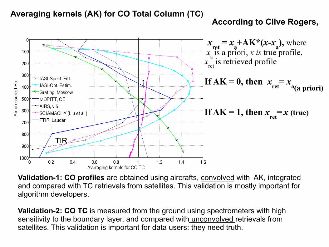
xret = xa+AK*(x-xa), where xa is a priori, x is true profile, xret is retrieved profile
If AK = 0, then xret= xa
If AK = 1, then xret= x (true)
TIR
According to Clive Rogers, Averaging kernels (AK) for CO Total Column (TC)
Validation-1: CO profiles are obtained using aircrafts, convolved with AK, integrated and compared with TC retrievals from satellites. This validation is mostly important for algorithm developers. Validation-2: CO TC is measured from the ground using spectrometers with high sensitivity to the boundary layer, and compared with unconvolved retrievals from satellites. This validation is important for data users: they need truth.
(a priori)
Example validation-1. MOPITT v.3, Emmons et al, ACP (2009)
A long-term drift of the bias is found
Example validation-2. MOPITT v.3, AIRS v.5, Yurganov et al, ACP (2010)
A long-term drift of MOPITT v3 data is found as well.
Aircraft data of 22 campaigns and sites are used
Year-round data from 7 FTIR NDACC sites (5 in NH, 2 in SH) are used
Convolved CO vs integrated profiles
University
Locations of observational sites in Russia: TC, local
Zvenigorod observatory is a rural site, Moscow spectrometer is in 1 km distance from the Kremlin
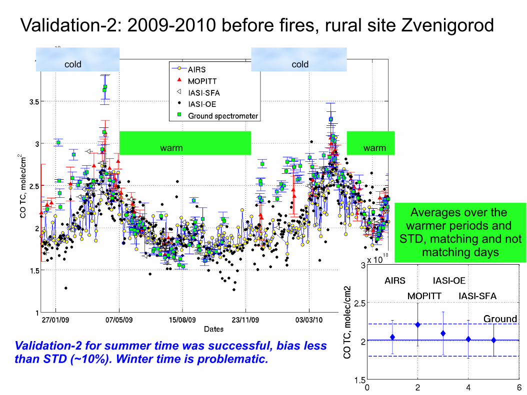
Validation-2: 2009-2010 before fires, rural site Zvenigorod
Averages over the warmer periods and
STD, matching and not matching days
cold
warm warm
cold
Validation-2 for summer time was successful, bias less than STD (~10%). Winter time is problematic.
Fires started at the end of July A map for 9 August, 2010. CO mixing ratio at 500 mb according
to AIRS V5 and aerosol index according to OMI.
CO
OMI Aerosol Index
Moscow
Validation-2 for the entire period, including winter and plume from fires, in Zvenigorod, ~100% underestimation during the fire
AIRS MOPITT
IASI-OE IASI-SFA
100%
June July
In situ CO mixing ratios near the surface in the rural site (Zvenigorod) and in Moscow, University campus.
PERIOD BEFORE THE ARRIVAL OF THE PLUME TO MOSCOW Urban CO has weekly (triangles) and diurnal (not shown) cycles, rural CO has diurnal cycle
(blue), but no weekly cycle (yellow circles).
In situ CO mixing ratio during the period when the plume covered Moscow (note a change in the Y-scale).
Before fires
Previous slide
No doubt that between 2 August and 10 August CO from wildfires
dominated over the anthropogenic CO, both in rural
and urban locations.
Fires started
Moscow area, the fire period, July – August 2010, CO total columns
1 spectrum
CO TC underestimation for TIR sensors sometimes is 2-fold or 3-fold. It is NOT a fault of the algorithm, rather it is explained by physics of radiative transfer through the atmosphere: low sensitivity in the BL.
Average TC for Moscow/Zvenigorod area: 2° x 3°, 2 – 9 Aug, 2010.
9 August, 2010, Moscow, two sites of in-situ sampling, ground spectrometer, and IASI-OE, three overpasses
CO VMR, ppm
CO TC, mol/cm2
IASI
IASI
Since 9 August the plume started moving away from Moscow and this was demonstrated by all three kinds of data.
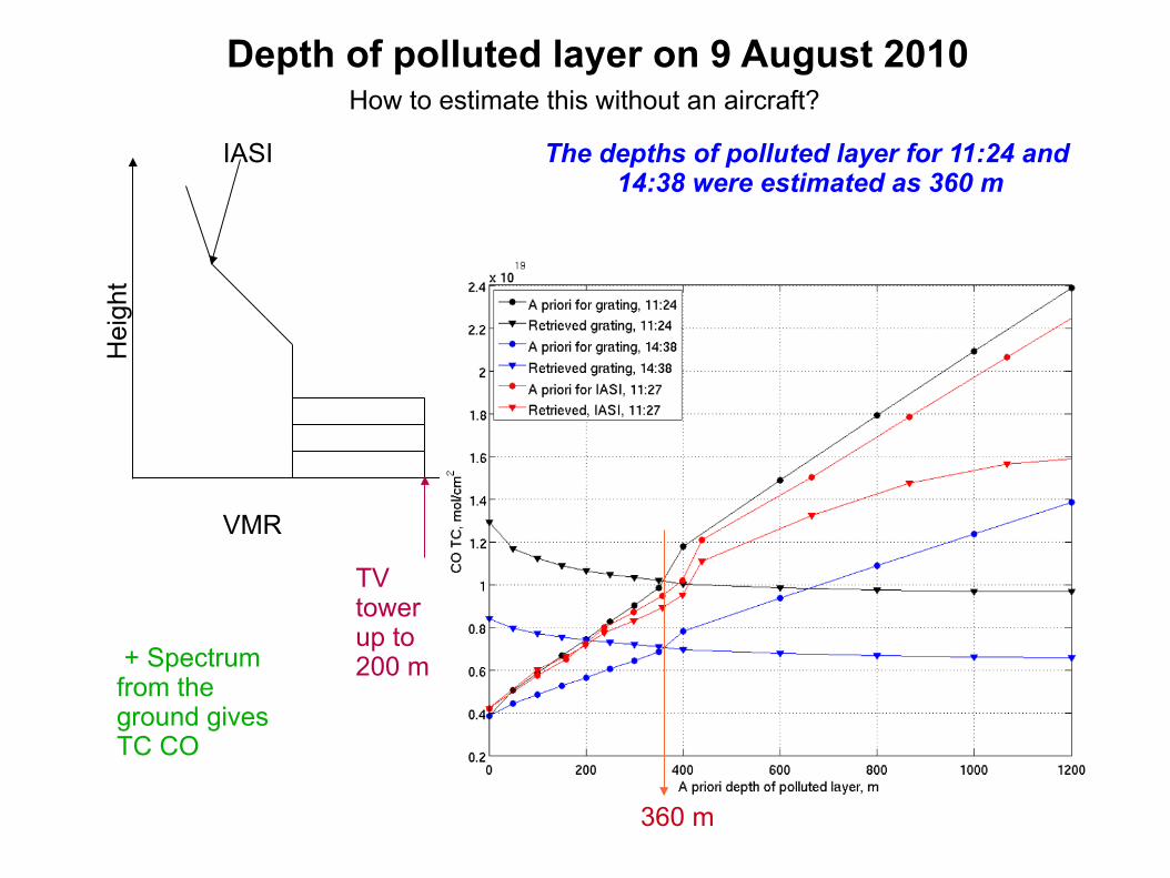
Depth of polluted layer on 9 August 2010 H
eigh
t
VMR
IASI
TV tower up to 200 m
360 m
The depths of polluted layer for 11:24 and 14:38 were estimated as 360 m
+ Spectrum from the ground gives TC CO
How to estimate this without an aircraft?
Results of validation over Moscow area were extrapolated on the entire plume.
Plume area in mln sq. km
Total mass M of pyro-CO in Tg
As retrieved
Corrected
Plume is determined as areas with VMR_500 > 150 ppb (yellow on the map)
P = dM/dt + L(OH oxidation) + L(wind removal)
[Spivakovsky et al.]
GEOS-5 CTM
CO emission P in Tg/day:
Between 2 and 9 August AIRS CO VMR-500 over Moscow was between 150 and 250 ppb
CO total mass M was converted into CO emission rate.
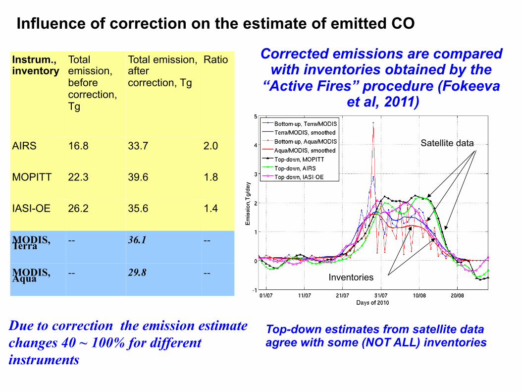
Instrum., inventory
Total emission, before correction, Tg
Total emission, after correction, Tg
Ratio
AIRS 16.8 33.7 2.0
MOPITT 22.3 39.6 1.8
IASI-OE 26.2 35.6 1.4
MODIS, Terra -- 36.1 --
MODIS, Aqua -- 29.8 --
Influence of correction on the estimate of emitted CO
Corrected emissions are compared with inventories obtained by the
“Active Fires” procedure (Fokeeva et al, 2011)
Satellite data
Inventories
Due to correction the emission estimate changes 40 ~ 100% for different instruments
Top-down estimates from satellite data agree with some (NOT ALL) inventories
CONCLUSIONS
1) First validation of TIR instruments over a plume of severe wildfires has shown a significant underestimation of CO TC NOT convolved with averaging kernels. NIR instruments are expected to work better for severe fires.
2) For the Moscow area CO TC for AIRS v5 and MOPITT v4 are 100% and 89% lower than ground truth, IASI-OE is 34% lower than ground truth.
3) The depth of polluted layer over Moscow is estimated as 360 m for August 9, 2010
4) Total emitted CO in Russia after correction (that amounted to 40 ~ 100%) are estimates as 34 – 40 Tg.