Fish Communities and Related Environmental Conditions of the Lower Boise River, Southwestern Idaho, 1974-2004 Scientific Investigations Report 2006–5111 Prepared in cooperation with the Idaho Department of Environmental Quality U.S. Department of the Interior U.S. Geological Survey
Transcript
Fish Communities and Related Environmental Conditions of the Lower Boise River, Southwestern Idaho, 1974-2004
Scientific Investigations Report 2006–5111
Prepared in cooperation with the Idaho Department of Environmental Quality
U.S. Department of the InteriorU.S. Geological Survey
Cover: Photograph of shorthead sculpin (Cottus confusus) from lower Boise River in Barber Dam Reach, southwestern Idaho. (Photograph taken by Dorene MacCoy, U.S. Geological Survey, 2006.)
Fish Communities and Related Environmental Conditions of the Lower Boise River, Southwestern Idaho, 1974–2004
By Dorene E. MacCoy
Prepared in cooperation with the Idaho Department of Environmental Quality
Scientific Investigations Report 2006-5111
U.S. Department of the InteriorU.S. Geological Survey
U.S. Department of the InteriorDirk A. Kempthorne, Secretary
U.S. Geological SurveyP. Patrick Leahy, Acting Director
U.S. Geological Survey, Reston, Virginia: 2006
For sale by U.S. Geological Survey, Information Services Box 25286, Denver Federal Center Denver, CO 80225
For more information about the USGS and its products: Telephone: 1-888-ASK-USGS World Wide Web: http://www.usgs.gov/
Any use of trade, product, or firm names in this publication is for descriptive purposes only and does not imply endorsement by the U.S. Government.
Although this report is in the public domain, permission must be secured from the individual copyright owners to reproduce any copyrighted materials contained within this report.
Suggested citation:MacCoy, D.E., 2006, Fish communities and related environmental conditions of the lower Boise River, southwestern Idaho, 1974–2004: U.S. Geological Survey Scientific Investigations Report 2006-5111, 36 p.
Purpose and Scope ……………………………………………………………………… 1Description of Lower Boise River Basin ………………………………………………… 3Historical Changes in the Fishery ……………………………………………………… 3Previous Fishery Investigations ………………………………………………………… 5
Idaho Department of Fish and Game, 1974-75 ……………………………………… 6U.S. Geological Survey, 1988 ……………………………………………………… 6Idaho Department of Fish and Game, 1992 and 1993-94 …………………………… 6U.S. Geological Survey, 1995–96 …………………………………………………… 7U.S. Geological Survey, 1996–97 …………………………………………………… 7U.S. Geological Survey, 2001 and 2004 ……………………………………………… 7U.S. Geological Survey and City of Boise, 2003 …………………………………… 7
Data Compilation and Analysis ……………………………………………………………… 7Subbasins, Sampling Reaches, and Water-Quality Sampling Locations ………………… 7Data-Collection Methods ………………………………………………………………… 8
Habitat, Hydrology, and Water Quality ……………………………………………… 8Fish Community …………………………………………………………………… 8
Analytical Methods ……………………………………………………………………… 9Fish Communities and Related Environmental Conditions …………………………………… 10
Habitat …………………………………………………………………………………… 10Hydrology ……………………………………………………………………………… 12Water Quality …………………………………………………………………………… 15Occurrence and Status of Fish in the Lower Boise River ……………………………… 16
Fish Communities Upstream and Downstream of Wastewater-Treatment Facilities ……………………………………………………………………………… 23
Analysis of Mountain Whitefish Condition ……………………………………………… 23Data Limitations and Potential Future Investigations ………………………………………… 25Summary ……………………………………………………………………………………… 26Acknowledgments …………………………………………………………………………… 27References Cited ……………………………………………………………………………… 27Appendix A. Relative percentage of abundance of fish species in the lower
Boise River, Idaho ………………………………………………………………………… 32
iv
Figures Figure 1. Map showing location of study area in the lower Boise River Basin,
southwestern Idaho ……………………………………………………………… 2 Figure 2. Graphs showing mean annual and mean monthly discharge rates for the
Boise River recorded at the U.S. Geological Survey Glenwood Bridge near Boise, Idaho (13206000) and near Parma, Idaho (13213000) gaging stations ……… 13
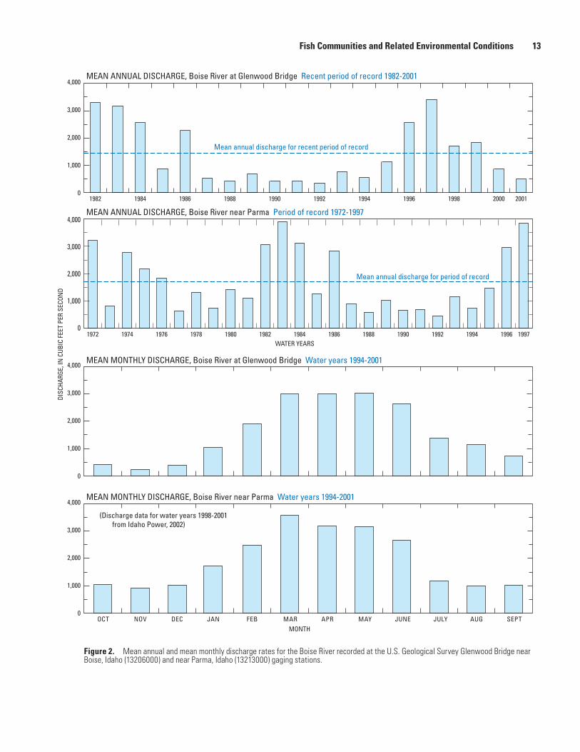
Figure 3. Schematic diagram showing diversions, drains, and tributaries along the Boise River from Lucky Peak Lake to the Snake River, southwestern Idaho ……… 14
Figure 4. Graphs showing mean monthly discharge for December and August recorded during pre- (1895–1916) and post-dam (1957–2002) periods at the U.S. Geological Survey Boise River near Boise gaging station (13202000), southwestern Idaho ……………………………………………………………… 15
for low-flow sampling events (November to April) in seven reaches of the lower Boise River, 1988–2003 ……………………………………………………… 22
Figure 14. Graph showing percentages of invertivores and piscivores versus percentages of omnivores and herbivores derived from 1996 fish collections in the lower Boise River, southwestern Idaho …………………………………… 22
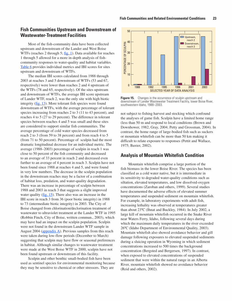
Figure 15. Graph showing changes in the occurrence of sculpin upstream and downstream of Lander Wastewater Treatment Facility, lower Boise River, southwestern Idaho, 1988–2003 …………………………………………………… 23
Figure 16. Graph showing comparison of relative weight equations calculated for mountain whitefish collected from the lower Boise River with the North American standard weight equation for mountain whitefish and measurements from least-disturbed rivers in southern Idaho …………………… 24
Figure 17. Graph showing mountain whitefish length and weight relations for the lower Boise River and least-disturbed sites in southern Idaho, 1988–2004 ……………… 25
v
Tables Table 1. Summary of U.S. Geological Survey and Idaho Department of Fish and Game
sampling of fish communities in the lower Boise River, southwestern Idaho, 1974 to 2004 ……………………………………………………………………… 5
Table 2. Fish sampling reach locations, lower Boise River, southwestern Idaho, 1988–2004 ………………………………………………………………………… 6
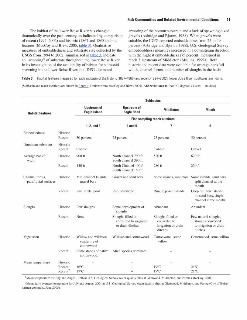
Table 3. Habitat features measured for each subbasin of the historic (1867–1868) and recent (1994–2002), lower Boise River, southwestern Idaho …………………… 11
Table 4. Median, minimum, and maximum values of instantaneous water-quality measurements and select constituent concentrations from sites on the lower Boise River, southwestern Idaho, 1994–2002 ……………………………… 15
Table 5. Occurrence of fish species in the lower Boise River, southwestern Idaho, 1988–2004 ………………………………………………………………………… 17
Table 6. Selected metrics and Index of Biological Integrity scores calculated for fish samples collected during low-flow periods (November to April) from the lower Boise River and least disturbed sites in southwestern Idaho ……………… 21
Table 7. Subbasin areas, selected land-use metrics, and fish Index of Biotic Integrity scores for selected sampling events on the lower Boise River, southwestern Idaho, 2000–03 …………………………………………………………………… 22
Conversion Factors, Datums, and Abbreviations
Inch/Pound to SI
Multiply By To obtain
cubic foot (ft3) 0.02832 cubic meter (m3) cubic foot per second (ft3/s) 0.02832 cubic meter per second (m3/s)foot (ft) 0.3048 meter (m)foot per mile (ft/mi) 0.189394 meter per km (m/km)inch (in.) 2.54 centimeter (cm)mile (mi) 1.609 kilometer (km)square mile (mi2) 2.590 square kilometer (km2)
SI to Inch/Poundgram (g) 0.03527 ounce, avoirdupois (oz)meter (m) 1.094 yard (yd) millimeter (mm) 0.03937 inch (in.)
Temperature in degrees Celsius (°C) may be converted to degrees Fahrenheit (°F) as follows:
°F=(1.8×°C)+32.
Specific conductance is given in microsiemens per centimeter at 25 degrees Celsius (µS/cm at 25°C).Concentrations of chemical constituents in water are given either in milligrams per liter (mg/L) or micrograms per liter (µg/L).
Datums
Vertical coordinate information is referenced to the North American Vertical Datum of 1988 (NAVD 88).
Horizontal coordinate information is referenced to the North American Datum of 1983 (NAD 83).
Altitude, as used in this report, refers to distance above the vertical datum.
vi
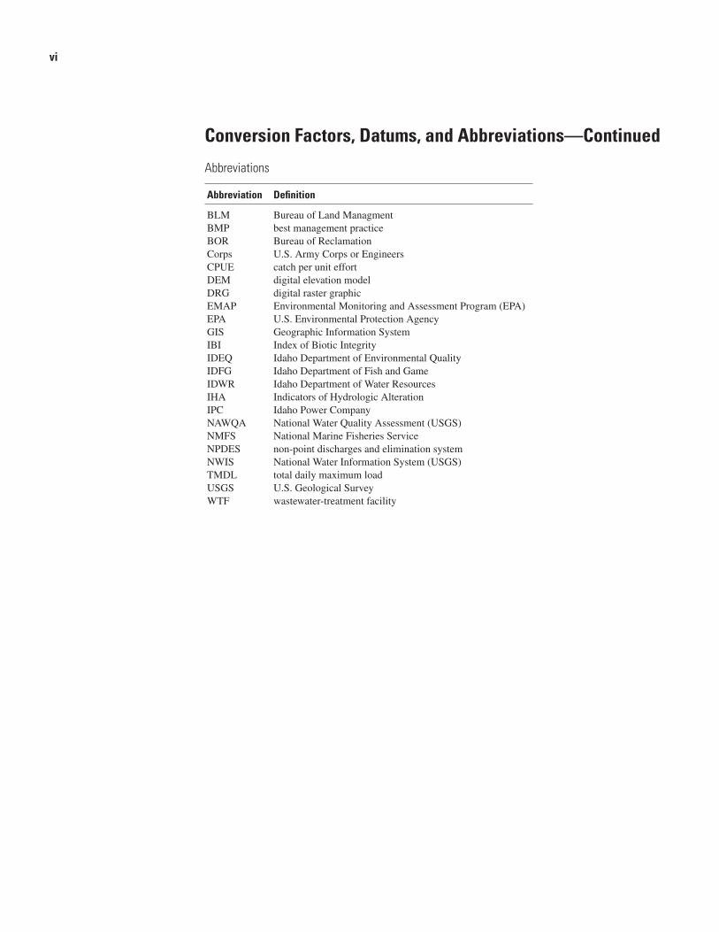
Conversion Factors, Datums, and Abbreviations—Continued
Abbreviations
Abbreviation Definition
BLM Bureau of Land ManagmentBMP best management practiceBOR Bureau of ReclamationCorps U.S. Army Corps or EngineersCPUE catch per unit effortDEM digital elevation modelDRG digital raster graphicEMAP Environmental Monitoring and Assessment Program (EPA)EPA U.S. Environmental Protection AgencyGIS Geographic Information SystemIBI Index of Biotic IntegrityIDEQ Idaho Department of Environmental QualityIDFG Idaho Department of Fish and GameIDWR Idaho Department of Water ResourcesIHA Indicators of Hydrologic AlterationIPC Idaho Power CompanyNAWQA National Water Quality Assessment (USGS)NMFS National Marine Fisheries ServiceNPDES non-point discharges and elimination systemNWIS National Water Information System (USGS)TMDL total daily maximum loadUSGS U.S. Geological SurveyWTF wastewater-treatment facility
AbstractWithin the last century, the lower Boise River has been
transformed from a meandering, braided, gravel-bed river that supported large runs of salmon to a channelized, regulated, urban river that provides flood control and irrigation water to more than 1,200 square miles of land. An understanding of the current status of the river’s fish communities and related environmental conditions is important to support the ongoing management of the Boise River. Therefore, fish community data from the U.S. Geological Survey and the Idaho Department of Fish and Game collected since 1974 were analyzed to describe the status of fish communities in the lower Boise River. Each set of data was collected to address different study objectives, but is combined here to provide an overall distribution of fish in the lower Boise River over the last 30 years. Twenty-two species of fish in 7 families have been identified in the lower Boise River—3 salmonidae, trout and whitefish; 2 cottidae, sculpins; 3 catostomidae, suckers; 7 cyprinidae, minnows; 4 centrarchidae, sunfish; 2 ictaluridae, catfish; and 1 cobitidae, loach.
Analysis of fish community data using an Index of Biotic Integrity (IBI) for Northwest rivers shows a decrease in the biotic integrity in a downstream direction, with the lowest IBI near the mouth of the Boise River. The number of tolerant and introduced fish were greater in the lower reaches of the river. Changes in land use, habitat, and water quality, as well as regulated streamflow have affected the lower Boise River fish community. IBI scores were negatively correlated with maximum instantaneous water temperature, specific conductance, and suspended sediment; as well as the basin land-use metrics, area of developed land, impervious surface area, and the number of major diversions upstream of a site. Fish communities in the upstream reaches were dominated by piscivorous fish, whereas the downstream reaches were
dominated by tolerant, omnivorous fish. The percentage of sculpin in the river decreased in a downstream direction, and sculpin disappear completely at sites downstream of Glenwood Bridge. The sculpin population increased downstream of the Lander wastewater-treatment facility within the last decade, possibly as a result of improved wastewater treatment. The condition of the mountain whitefish (Prosopium williamsoni) throughout the lower Boise River was good and was similar both to the condition of mountain whitefish from least-disturbed rivers in southern Idaho and to the North American standard weight for mountain whitefish.
Introduction
Purpose and Scope
Fish community sampling has been included in some water-quality studies in the lower Boise River from 1974 to 2004. These sampling events have not been summerized in one report until now. These studies differed somewhat in objectives, sampling protocols, and findings. The data, however, can be compiled and summarized for selected reaches of the lower Boise River to further the understanding of the fish community and associated environmental conditions. The purposes of this report are to describe the occurrence and distribution of fish species of the lower Boise River using data collected by IDFG and USGS from 1974 to 2003 to describe temporal trends in fish-community structure and fish condition, and to identify environmental factors affecting occurrence, distribution, and community trends. Historic land and channel features from the late 1800s were used to compare fish habitat prior to and following hydrologic modification of the lower Boise River Basin.
Fish Communities and Related Environmental Conditions of the Lower Boise River, Southwestern Idaho, 1974-2004
By Dorene E. MacCoy
Area
div
erte
d to
nei
ghbo
ring
basi
n
Area
div
erte
d to
ne
ighb
orin
g ba
sin
Figu
re 1
. Lo
catio
n of
stu
dy a
rea
in th
e lo
wer
Boi
se R
iver
Bas
in, s
outh
wes
tern
Idah
o.
2 Fish Communities and Related Environmental Conditions of the Lower Boise River, Idaho, 1974-2004
84
84
84
20
26
44
116°
00’
115°
52’3
0”
43°1
5’
43°3
0’
43°4
5’
43°5
2’30
”
117°
00’
116°
45’
116°
30’
116°
15’
0 05
5
10 K
ILOM
ETER
S10 M
ILES
EL
MO
RE
AD
A
BOIS
E
CA
NY
ON
GE
MP
AY
ET
TE
Dixie
Drain
Will
ow
Cre
ek
Mil
lSl
ough
Mas
onSl
ough
Fiv
emil
eC
reek
Tenm
ile
Creek
Thur
man
Drai
n
Eagl
eDr
ain
Mas
on
Creek
New
York
Canal
New
York
Cana
l
Cre
ek
Fifteen
mile
Creek
Wilson
Drain
Lak
e Low
ell
Boi
se
Riv
er
Boise
Rive
r
SnakeRiver
Log
gers
Cre
ek
Indi
an
South
Luc
kyPe
akL
ake
IDA
HO
Wes
tern
Sna
keRi
ver P
lain
Stud
y A
rea
Snak
e
River
Boi
se
Par
ma
Not
us
Cal
dwel
l
Mid
dlet
on
Star
Nam
pa
Kun
a
Mer
idia
n
Eag
le
Gar
den
Cit
y
Sele
ct o
ne o
f the
sub
-bas
ins
liste
d be
low
to
view
that
sub
-bas
in o
n th
e st
udy
area
Upst
ream
of E
agle
Isla
nd
Upst
ream
of E
agle
Roa
d(s
outh
cha
nnel
)
Upst
ream
of M
iddl
eton
Upst
ream
of t
he M
outh
1321
3000
1320
2000
1320
3510
1320
6000
1321
0050
1321
2500
9
23
45
67
8
1
Wes
t Boi
seW
aste
wat
er
Trea
tmen
tFa
cilit
y
Land
erW
aste
wat
er
Trea
tmen
tFa
cilit
y
Glen
woo
dBr
idge
Barb
er Dive
rsio
nDa
m
Dam
Conw
ayGu
lch West
Hartley
Gulch
East
Hartl
eyGulc
h
BOISE
MOUNTA
INS
Luck
yPe
akDa
m
Eagl
e Is
land
Base
from
U.S
. Geo
logi
cal S
urve
y di
gita
l dat
a, 1
:100
,000
, 198
0Al
bers
Equ
al-A
rea
proj
ectio
nSt
anda
rd p
aral
lels
43
30',
47 3
0',a
nd -1
14 0
0', 4
1 45
'N
o fa
lse
east
ing
or fa
lse
north
ing
EXPL
AN
ATIO
N
Wat
er-q
ualit
y an
d/or
dis
char
ge s
ampl
ing
site
with
USG
S ga
ge n
umbe
r
Reac
h w
here
fish
wer
e sa
mpl
ed—
See
tabl
e 2
Hyd
rolo
gic
Uni
t Cod
e (H
UC)
170
5011
4 bo
unda
ry
Clea
r all
sele
ctio
ns
6
1321
0050
Description of Lower Boise River Basin
The 1,290 mi2 lower Boise River Basin is located in Ada and Canyon Counties in southwestern Idaho between Lucky Peak Dam (river mile 64) and the confluence of the Boise and Snake Rivers (river mile 395) (fig. 1). The basin contains the most industrialized and urbanized areas in Idaho. In 2000, the population in Ada and Canyon Counties was about 432,300 (U.S. Census Bureau, 2002), which is 33 percent of Idaho’s population. Population in 2000 increased more than 46 percent over the 1990 population in these two counties.
The lower Boise River Basin is in the northern part of the western Snake River Plain (fig. 1), and it lies in a broad, alluvium-filled basin with several step-like terraces, or benches, which are more pronounced and continuous on the south side of the river. The upper basin, upstream of Lucky Peak Dam, is mountainous and sparsely populated. Downstream of Lucky Peak Dam, the basin floor slopes northwestward at a gradient of about 10 ft/mi. The altitude of the basin near Lucky Peak Dam is about 2,800 ft above sea level; the altitude near the river mouth is about 2,200 ft (Thomas and Dion, 1974). In addition to the lower Boise River, several tributaries are interconnected by a complex irrigation system of canals, laterals, and drains. Climate in the lower Boise River Basin is characterized as semiarid; winters are cool and wet, and summers are warm and dry. Some years considered to have normal to high amounts of precipitation are 1995 to 1998, and 2000; and some years categorized as severe drought are 1999, 2001, and 2002. Thomas and Dion (1974), Mullins (1998), and the lower Boise subbasin assessment conducted by the Idaho Department of Environmental Quality (1999) provide more information on the geography, geology, and climate of the lower Boise River Basin.
Flow in the lower Boise River between Lucky Peak Dam and the mouth is controlled primarily by reservoir regulation, irrigation withdrawals and return flows, and seepage of shallow ground water (Thomas and Dion, 1974). The three reservoirs upstream in the upper Boise River Basin have a combined storage capacity of about 1 million acre-ft. These reservoirs are managed primarily for irrigation and flood control, and secondarily for recreation and power generation (Mullins, 1998). Some storage is assigned to salmonid flow augmentation in Lucky Peak Lake as required by the National Marine Fisheries Service (NMFS) 1995 Biological Opinion for the Snake River Basin (Bureau of Reclamation, accessed March 2002, at http://www.usbr.gov/dataweb/html/boise.html).
Land use and land cover in 1994 within the lower Boise River Basin included urban activities (4 percent); irrigated agriculture, pasture, and other agriculture-related activities (47 percent); and rangeland, water, and unclassified land (49 percent) (Kramer and others, 1994). Crops in the basin consist of alfalfa hay and seed, corn and corn seed, wheat, potatoes, onions, sugar beets, barley, spearmint and
peppermint, and dry edible beans (Koberg and Griswold, 2001). This land use contrasts with that in the upper Boise River Basin, which consists primarily of logging and recreation. Parts of the upper basin were heavily mined for gold during the late 1800s and early 1900s (Love and Benedict, 1940; Chandler and Chapman, 2001).
Land use in the lower Boise River Basin has undergone major changes since 1994; particularly conversions of large tracts of farmland to residential subdivisions and commercial facilities, and conversions of many residential areas in and near cities to businesses, shopping centers, and parking lots. These land-use changes typically cause a reduction in agricultural non-point runoff, and may increase urban stormwater runoff to the lower Boise River and its tributaries, depending on the development practices implemented. Under the Clean Water Act, numerous public and private entities in the lower Boise River Basin are required to seek non-point discharge and elimination system (NPDES) stormwater discharge permits. These permits require these entities to implement best management practices that reduce pollutant loads to the “maximum extent practicable” (Johanna Bell, City of Boise, written commun., April 17, 2006). U.S. Environmental Protection Agency (EPA) regulation guidance and requirements are available online at http://yosemite.epa.gov/r10/WATER.NSF/webpage/Storm+Water?OpenDocument (accessed June 15, 2006). State of Idaho guidance is available online at http://www.deq.state.id.us/water/permits_forms/permitting/catalog_bmps.cfm (accessed June 16, 2006). Boise municipal regulations and guidance are available online at the Partners for Clean Water web site at http://www.partnersforcleanwater.org (accessed June 16, 2006). The City of Boise stormwater program is implementing a plan to reduce the stormwater load of sediment (p. 61 of Lower Boise River total daily maximum load [TMDL] at http://www.lbrwqp.boise.id.us/tmdl/tmdl_4.pdf; accessed June 15, 2006) and total phosphorus. The stormwater sediment load reduction is a result of the development of a sediment TMDL (Idaho Department of Environmental Quality, 1999). Development of a total phosphorus TMDL and a temperature assessment are currently being done for the lower Boise River (Robbin Finch, City of Boise, written commun., November 2005).
Historical Changes in the Fishery
The fishery of the lower Boise has changed over time partly in response to multiple human impacts caused by development of the study area. Settlers began to divert water from the lower Boise for irrigation in the late 1800s and early 1900s; irrigation return flows were an early source of water-quality and stream habitat degradation. Also at that time, extensive mining began in the upper basin, and numerous lumber mills were operated east of Boise to supply timber for development (Stacy, 1993; Simonds, 1997). Temporal changes due to natural factors (climate change) in the lower Boise are unknown.
Soon after development began, farmers recognized the need for flood control and storage of irrigation water, which led to the 1902 “Boise Project,” one of the earliest projects by the Bureau of Reclamation (Stacy, 1993; Simonds, 1997). By 1906, the New York Canal and several small irrigation projects had been built as part of the Boise Project. One of the Bureau of Reclamation’s (BOR) “big dams,” Arrowrock, was built in 1915 on the mainstem Boise River, about 17 mi upstream of the City of Boise. The U.S. Army Corps of Engineers (Corps) built Anderson Ranch Dam on the South Fork of the Boise River (the world’s highest earthfill dam at the time of its completion in 1950). Anderson Ranch Dam is the uppermost storage facility on the Boise system located 42 mi upstream of Arrowrock Dam. Anderson Ranch Dam and Powerplant is a multiple-purpose structure that provides benefits in irrigation, power, and flood and silt control (accessed April 17, 2006, at: http://www.usbr.gov/power/data/sites/anderson/anderson.html). In 1957, the Corps built the third and final large dam, Lucky Peak, less than 10 mi upstream of the City of Boise, in response to concerns about potential flooding and to the need for additional irrigation water (Stacy, 1993). The construction of these dams affected the lower Boise fishery by blocking fish passage, changing the thermal regime and flow patterns of the river, modifying sediment transport and substrate size, and altering water quality and channel shape.
Progressive urbanization around the City of Boise increased the need to treat wastewater prior to discharge to the lower Boise River. The construction of wastewater-treatment facilities (WTFs) downstream of Boise in the early 1950s helped to disinfect wastewater entering the river, but introduced toxic concentrations of chlorine that resulted in frequent fish kills (Stacy, 1993). In the late 1950s, the lower Boise River was identified as one of the three most polluted waters in Idaho (Casey and Webb, 1996; Chandler and Chapman, 2001). In 1976, a second outlet was proposed for installation in Lucky Peak Dam to implement a minimum flow of about 150 ft3/s during winter, which helped to dilute effluent. According to the IDEQ, minimum flow varied as a result of water allocations downstream (Idaho Department of Environmental Quality, 1999). Continuing cleanup efforts in the lower Boise River Basin include upgrading WTFs and implementing best management practices (BMPs) for urban and agricultural runoff.
Prior to construction of dams, levees, and extensive irrigation in the lower Boise River Basin, a large (as wide as 0.75 mi) hyporheic zone (an area beneath the main channel where surface water interacts with ground water) existed. The river’s interaction with the hyporheic zone allowed the river to develop side channels and other habitat for refuge and areas ideal for salmon spawning and rearing (David Blew, Idaho Department of Water Resources, oral commun.,
2002). Operation of the three Boise River dams for irrigation and flood control created a flow regime with higher than natural flows during the peak irrigation season (April through September) and lower than natural flows during the nonirrigation season (October through March). The change in hydraulic regime and the construction of levees has caused the lower reaches of the lower Boise River to incise to the point that depositional areas, backwater sloughs, and wetlands associated with the hyporheic zone have diminished (David Blew, Idaho Department of Water Resources, oral commun. 2002; MacCoy and Blew, 2005). For further information on the effect of dams on alluvial rivers please refer to Williams and Wolman (1984), Collier and others (1996), and the World Commission on Dams (2000).
The lower Boise fishery was described in the early 1800s as the “most renowned fishing place in the country,” because of the large numbers of salmon caught there (Pratt and others, 2001). The lower reaches of the Snake and its adjoining tributaries, which include the lower Boise River, were highly productive fisheries in the early 1800s for the Shoshone-Bannock Tribes (accessed March 2005, at http://www.shoshonebannocktribes.com/fhbc.html). The historical distributions of Chinook salmon (Onchorhynchus tshawytscha) and steelhead (Oncorhynchus mykiss) were evaluated by Idaho Power Company (IPC) as part of an ongoing hydroelectric project relicensing effort for the Hells Canyon Complex on the Snake River. The Complex includes the lower Boise River as an important tributary. Chandler and Chapman (2001) documented evidence of Chinook salmon spawning in the lower reaches of the lower Boise River until the early 1860s, coincident with the time when mining and irrigation projects began. They also reported steelhead runs in the lower Boise River, as well as the presence of Pacific lamprey (Lampetra tridentatus) in the river near Caldwell.
Within the last century, the lower reaches of the lower Boise River changed from a thriving, cold water fish community with significant numbers of salmon and trout to a cool- and warm-water fish community. Nonindigenous warm-water fishes, including common carp (Cyprinus carpio), largemouth bass (Micropterus salmoides), smallmouth bass (M. dolomieu), bluegill (Lepomis macrochirus), channel catfish (Ictalurus punctatus), tadpole madtom (Noturus gyrinus), and oriental weatherfish (Misgurnus anguillicaudatus) have been introduced into the lower Boise River since the turn of the 20th century (Mullins, 1999a; Chandler and Chapman, 2001). Some of these nonindigenous fish species are known to be detrimental to salmonid populations (Li and others, 1987; Fuller and others, 1999). The Hells Canyon Complex of dams (Brownlee, Oxbow, and Hells Canyon), built between 1959 and 1967, prevented salmonids from entering the lower Boise River (Chandler and Chapman, 2001). Chandler and Chapman (2001) concluded, following
4 Fish Communities and Related Environmental Conditions of the Lower Boise River, Idaho, 1974-2004
Table 1. Summary of U.S. Geological Survey and Idaho Department of Fish and Game sampling of fish communities in the lower Boise River, southwestern Idaho, 1974 to 2004.
[Abbreviations: IDFG, Idaho Department of Fish and Game; USGS, U.S. Geological Survey; WAG, Lower Boise Watershed Advisory Group; WRI, Water Resources Investigation; WTF, wastewater-treatment facility]
Date ProjectLead
collection agency
Study objectives Reference
March 1974 to February 1975
Snake River Fisheries Investigations
IDFG Identify fish population, and habitat and water-quality characteristics
Idaho Department of Fish and Game, 1975
January 1988 to March 31, 1988
Regional Fishery Management Investigation
IDFG Fish community assessment upstream and downstream of WTF
Frenzel and Hansen, 1988; Idaho Department of Fish and Game, 1988; Frenzel, 1990
March to April 1992
Regional Fishery Management Investigation
IDFG Fish community assessment upstream and downstream of WTF
Idaho Department of Fish and Game, 2000
December 1993 to March 1994
Regional Fishery Management Investigation
IDFG Characterize trout1 and whitefish2 population
Idaho Department of Fish and Game, 2000
February and March 1995, and October 1996
USGS WRI USGS Fish community assessment upstream and downstream of WTF
Mullins, 1998
December 1996 to August 1997
USGS WRI USGS Examine biological integrity of fish population as related to water quality
Mullins, 1999
December 2001 USGS Idaho Statewide Water Quality Network
USGS Examine biological integrity of fish population as part of a long-term trend statewide water-quality study
MacCoy, 2004
November 2003 USGS WRI USGS Fish community assessment upstream and downstream of WTF
Data available on USGS web site at http://id.water.usgs.gov/projects/fish/index.html
December 2004 USGS Idaho Statewide Water Quality Network
USGS Examine biological integrity of fish population as part of a long-term trend statewide water-quality study
Data available on USGS web site at http://id.water.usgs.gov/projects/fish/index.html
the 2001 study, that the lower Boise River was no longer suitable to support salmonid spawning because of high water temperatures (greater than 20ºC) in the late summer.
Benke (1992) designated all native rainbow trout (Oncorhynchus mykiss) in the Columbia River Basin east of the Cascade Mountains, which includes the lower Boise River Basin, as redband trout. The Idaho Department of Fish and Game (IDFG) has not verified that the wild rainbow trout in the lower Boise River are a genetically distinct species (Jeff Dillon, oral commun., November 2005). The American Fisheries Society has grouped redband trout and rainbow trout into one group but does recognize that with additional genetic data this could be revised (Nelson and others, 2004). The IDFG manages the lower Boise River as a “put and take” fishery through the City of Boise (Idaho Department of Fish and Game, 2000). IDFG has created a very popular urban fishery by stocking the river with hatchery-reared rainbow
trout of catchable size (greater than 6 in. total length). For example, more than 56,000 rainbow trout were stocked in the lower Boise River in 2004 (accessed June 15, 2006, at http://fishandgame.idaho.gov/apps/stocking/year.cfm?region=3). In addition, IDFG has stocked Chinook salmon and steelhead in the lower Boise River.
Previous Fishery Investigations
The impairment of water quality and biological integrity in the lower Boise River and several of its tributaries has been evaluated as part of Federal and State monitoring programs, but only a few of those programs included an examination of fish communities (MacCoy, 2004). A summary of U.S. Geological Survey (USGS) and IDFG fish sampling in the lower Boise River since 1974 is shown in table 1, and the location of sampling reaches is shown in table 2.
Table 2. Fish sampling reach locations, lower Boise River, southwestern Idaho, 1988–2004.
[Reach locations are shown in figure 1. Reach lengths varied according to project sampling protocol; upstream and downstream latitude and longitude given is for the maximum reach sampled using North American Datum of 1983 (NAD 83). Abbreviations: WTF, wastewater-treatment plant]
Reach No.
Reach name Subbasin location Upstream latitude/longitude Downstream latitude/longitude
1 Barber Dam Upstream of Eagle Island 116º08’03”W/43º34’07”N 116º09’34”W/43º34’58”N
2 Upstream of Lander WTF Upstream of Eagle Island 116º13’53”W/43º37’02”N 116º14’05”W/43º37’23”N
3 Downstream of Lander WTF Upstream of Eagle Island 116º15’02”W/43º38’30”N 116º16’46”W/43º39’38”N
4 Upstream of West Boise WTF Upstream of Eagle Road 116º18’09”W/43º40’10”N 116º19’22”W/43º40’16”N
5 Downstream of WTF Upstream of Eagle Road 116º20’23”W/43º40’30”N 116º21’15”W/43º40’29”N
6 Star Upstream of Middleton 116º27’01”W/43º40’47”N 116º28”13”W/43º41’02”N
7 Middleton Upstream of Middleton 116º33’34”W/43º40’55”N 116º34’17”W/43º41’03”N
8 Caldwell Upstream of Mouth 116º41’19”W/43º40’45”N 116º41’40”W/43º40’40”N
9 Upstream of Mouth Upstream of Mouth 116º27’03”W/43º67’41”N 116º58’16”W/43º46’41”N
Idaho Department of Fish and Game, 1974-75The IDFG conducted a survey of fish populations and
water quality in the lower Boise from its mouth upstream to Barber Dam during 1974 and 1975 (Idaho Department of Fish and Game, 1975). The 1974 sampling of 10 reaches (1 through 9 and a reach near Notus, fig. 1) of the lower Boise River was part of the Snake River Fisheries Investigation (a survey of the physical and biological information of the Snake River upstream of Brownlee Reservoir; Idaho Department of Fish and Game, 1975). The lower Boise River was included in the investigation because of its importance to the Snake River drainage. This study was the first extensive assessment of the fish community in the lower Boise River. The IDFG found abundant mountain whitefish populations in the Barber Dam to Star reach. The report concluded that these fish were competing with juvenile and adult trout, and it recommended cropping the population. The IDFG also recommended that this reach be managed as a cold water fishery. The Star to mouth reach was dominated by warm water species (mainly in the sloughs), and the IDFG recommended that the reach be managed as a warm water fishery. They also stated that minimum and maximum flow requirements should be established for the well being of aquatic life (Idaho Department of Fish and Game, 1975).
U.S. Geological Survey, 1988In 1988, the USGS evaluated the effect of multiple
wastewater discharges on water quality and aquatic communities in the lower Boise River (Frenzel, 1988; 1990).
The study was designed primarily to assess trace-element effects on aquatic communities. Artificial substrates were used to assess macroinvertebrate communities, and IDFG assisted in the assessment of the fish community by electrofishing reaches 2 through 5 (fig. 1) upstream and downstream of the Lander and West Boise WTFs (reaches 2, 3, 4, and 5; fig. 1). Frenzel (1988) found no evidence of adverse affects of the effluent from these facilities on the macroinvertebrate and fish communities. Asbridge and Bjornn (1988) included information from the USGS study and additional data in a survey of potential and available salmonid habitat in the lower Boise River. They concluded that the lower Boise River was not ideally suited to trout due to high velocities in the upper reaches and high temperature in the lower reaches. Winter cover also was mentioned as affecting trout abundance.
Idaho Department of Fish and Game, 1992 and 1993-94
Population estimates of trout and mountain whitefish were conducted by IDFG during the spring of 1992 and the winter of 1993–94 at reach locations similar to those in 1988 through the City of Boise (Frenzel, 1988). Idaho Department of Fish and Game (2000) noted that sportfish populations continued to decrease, with the most likely cause being the low winter flows.
� Fish Communities and Related Environmental Conditions of the Lower Boise River, Idaho, 1974-2004
U.S. Geological Survey, 1995–96As a follow-up study to the 1988 and 1992 studies, the
USGS, in cooperation with the City of Boise, sampled fish communities upstream and downstream of the Lander and West Boise WTFs during the spring of 1995 and the autumn of 1996 (reaches 2 through 5, fig. 1). An IBI was calculated using percentages of sculpin, salmonids, pollution-tolerant species, invertivores, juvenile trout (assumed to be those less than 100 mm total length), juvenile mountain whitefish (assumed to be those less than 210 mm total length), and percentage of individuals with one or more anomalies (Mullins, 1999b). High flows in autumn of 1996 in the lower Boise River affected sampling efforts. Therefore, accurate species abundance estimates could not be made, and this data are not included in this report. The IBI scores were similar among the four sampling reaches, although Mullins (1999b) noted variability between riffles sampled within a reach. He suggested that more frequent sampling would help to determine any statistical differences between reaches. Sculpins were only found upstream of the Lander WTF, with shorthead sculpin (Cottus confusus) being the most abundant species (appendix A). Mullins (1996a) also noted the absence of juvenile trout at all locations, which may have been an indication of poor natural recruitment.
U.S. Geological Survey, 1996–97The USGS conducted fish-community surveys at five
locations (reaches 1, 3, 7, 8 and 9; fig. 1) during December 1996 and August 1997, as part of an ongoing water-quality and biological integrity study done in cooperation with IDEQ and the Lower Boise River Water Quality Plan (Mullins, 1999a). Representative reaches at each location were sampled with both boat and backpack electrofishing equipment. IBI for each reach using five metrics (percentages of sculpin, salmonids, pollution-tolerant species, invertivores, and individual anomalies) were summarized only for the data collected in 1996 (Mullins, 1999a). The 1997 data were of poor quality due to problems associated with high-flow sampling, and those data were not used in the assessment of biotic integrity. The IBI scores calculated for reaches 3, 7, and 9 (fig. 1) in 1996 indicated a longitudinal decrease in biological integrity, with the lowest score from reach 9 near the mouth (fig. 1). At reach 9, the fish community consisted of a high percentage of pollution-tolerant species, a reduced number of salmonids and invertivores, and a relatively high occurrence of anomalies. Mullins (1999a) concluded that the lower Boise River was moderately impaired in the upper reaches, and that river water quality decreased gradually downstream. He described a lack of well-developed pools, riffles, and fish cover, and he also noted extended low winter flow and high summer water temperatures in the lower
reaches. Mullins (1999a) recommended monitoring the fish community and habitat in the lower Boise River on a 3- to 5-year cycle.
U.S. Geological Survey, 2001 and 2004The USGS sampled the fish community at reach 3 (fig. 1)
in 2001 and 2004, as part of the Idaho Statewide Water Quality Network. Data from 2001 were summarized in MacCoy (2004), but the data collected in 2004 have not been previously published. The IBI score calculated for reach 3 in 2001 (68) was higher than the score calculated for the 1996 data (57), indicating a possible improvement to the fish community.
U.S. Geological Survey and City of Boise, 2003In November 2003, the USGS, in cooperation with the
City of Boise, conducted another follow-up study of the fish community upstream and downstream of the WTFs. This evaluation included reaches 1 through 5 (fig. 1), and the sampling reaches were extended to 40 times the channel width (about 1 mi long) to capture the maximum fish diversity in each reach as described by Maret and Ott (2003). The 2003 data have not been previously published.
Data Compilation and Analysis
Subbasins, Sampling Reaches, and Water-Quality Sampling Locations
The lower Boise River Basin was divided into four subbasins to assess associations in land use, habitat, and fish community. The divisions were selected using both geomorphic channel features and water-quality aspects of the river. These divisions are described in more detail in MacCoy and Blew (2005). These subbasins include: upstream of Eagle Island to Lucky Peak Dam (upstream of Eagle Island); upstream of the south channel of the Boise River at Eagle Island downstream of West Boise WTF at Eagle Road (upstream of Eagle Road); upstream of Middleton (Middleton); and upstream of mouth (Mouth) (fig. 1). Each subbasin consists of one to three fish sampling reaches and one to two water-quality sampling locations (table 2). Beginning in 1994, the USGS sampled water quality at four lower Boise River sites: Boise River below Diversion Dam 13203510 (Diversion), Boise River above Glenwood Bridge 1320600 (Glenwood), Boise River near Middleton 13210050 (Middleton), and Boise River near Parma 13213000 (Parma) (fig. 1). Diversion and Glenwood are in the upstream of Eagle Island subbasin, Middleton is in the Middleton subbasin, and Parma is in the upstream of Mouth subbasin.
Data Compilation and Analysis 7
Data-Collection Methods
Habitat, Hydrology, and Water QualityData pertaining to recent land and channel features were
obtained primarily from biological surveys done between 1994 and 2002 by the USGS (Mullins, 1999a). With the exception of measurements of channel width, most of the data collected were qualitative. Recent measurements of bankfull width were obtained from cross sections of the lower Boise River surveyed in 1997 and 1998 (Hortness and Werner, 1999) and from surveys at biological sampling sites (Mullins, 1999a).
Historic geomorphic data (1867 and 1868) are used to compare fish habitat prior to and following hydrologic modification in the lower Boise River Basin. Land-cover data from cadastral survey notes obtained from the Bureau of Land Management (BLM) for the lower Boise Valley were used to re-create the “historical” lower Boise River. These data were summarized by the Idaho Department of Water Resources (David Blew, written commun., 2003) and in the methods published by MacCoy and Blew (2005). In their notes, surveyors documented slough and meander widths and azimuths, which typically were measured at the mean high-water mark. Therefore, these measurements were used to indicate bankfull width of the river and tributaries. The surveyors also noted land features such as gravel or sand bars.
Flow records were obtained from the National Water Information System web site (NWIS). Historic and recent flow conditions were compared by analyzing discharge data from the USGS gaging station “Boise River at Boise,” (13202000), which has the longest record on the lower Boise River from 1895 to 2002 (U.S. Geological Survey National Water Information System web site, accessed October 1, 2005, at http://nwis.waterdata.usgs.gov/id/nwis/qwdata). The Indicators of Hydrologic Alteration (IHA) program was used to evaluate the magnitude of change in the natural flow regime following dam construction (The Nature Conservancy, 2001). The magnitude and variation of mean monthly discharges and the average monthly discharges for December and August were summarized for the Boise River at the Boise streamflow gaging station.
Water-quality collection methods and data on the lower Boise River from 1994 to 2002 presented in this report are published in MacCoy (2004). Temperature, dissolved oxygen, pH, and specific conductance data were based on instantaneous readings. Data on suspended sediment and nutrients were based on depth- and width-integrated water samples.
Fish CommunityFish-community data were compiled from studies
conducted by the USGS and IDFG between 1974 and 2004 (table 1). U.S. Geological Survey fish sampling reaches were usually located near water-quality sampling locations in the lower Boise River (MacCoy, 2004). Fish communities were assessed by electrofishing a representative reach of river using protocols developed by the USGS National Water Quality Assessment (NAWQA) Program (Meador and others, 1993). Shallow riffle areas were sampled using backpack electrofishing equipment (Smith-Root models 12 and 12A), and deep-water areas were sampled using a drift boat or a pontoon boat carrying a Smith-Root model VI-A and a 5,000-watt, 240-volt generator with either multiple handheld or two bow-mounted electrodes. Netting crews consisted of four to six people and included personnel from IDFG, USGS, and the City of Boise. Usually two electrofishing passes were made through each reach, and an effort was made to sample all representative habitat types. Captured fish were held in livewells until they were processed and released. Fish were identified, counted, measured, weighed, and examined for types and numbers of anomalies. Fish were identified onsite by Dorene MacCoy and Terry Maret, USGS; Don Zoroban, IDEQ; and Dale Allen, IDFG using taxonomic names described in Nelson and others (2004). Voucher samples were taken of selected species, and those samples are in the collection of the Orma J. Smith Museum of Natural History, Albertson College, Caldwell, Idaho. The taxonomy of sculpin (Cottus sp.) and dace (Rhinichthys sp.) was verified by Dr. Carl E. Bond and Dr. Douglas F. Markel, Oregon State University, Corvallis, Oregon, and by Dr. Gordon Haas, University of British Columbia, Vancouver, Canada.
Sampling techniques in November 2003 and August 2004 changed slightly with the use of a raft-mounted electrofisher and techniques described in the U.S. Environmental Protection Agency’s Environmental Monitoring and Assessment Program (EMAP) fish sampling protocols (Peck and others, 2002). Each sampling reach was 40 times the mean channel width, or about 1 mi. A raft-mounted electrofisher was used to collect fish from near-shore habitats while floating downstream through the entire sampling reach. In addition, 100 m of riffle within each reach were sampled using a backpack electrofisher to capture small benthic species often missed by boat electrofishing. Sample data for these studies are summarized on the USGS Web site, accessed June 15, 2006, at http://id.water.usgs.gov/projects/fish/index.html. Increasing the reach length provided a larger sample of the population but the percentage of composition of each species would be similar.
� Fish Communities and Related Environmental Conditions of the Lower Boise River, Idaho, 1974-2004
General locations of IDFG sampling areas were predetermined by either the senior IDFG fishery research biologist or cooperators such as the USGS and the City of Boise. The IDFG used boat-mounted or shore-based electrofishing equipment for all fish community sampling. For the 1974 sampling, boats were powered upstream against the current while electrofishing (Idaho Department of Fish and Game, 1975). Boat-mounted electrofishing equipment using a variable voltage pulsator (0-600 watts DC) was powered by a 2,000 watt portable generator. This equipment was mounted on either an aluminum jet boat or on a smaller boat where maneuverability was limited. All species were counted, game fish were weighed and measured, and a summary of findings was produced (Idaho Department of Fish and Game, 1975).
In 1988, the City of Boise and the USGS worked with the IDFG to choose sampling locations in reaches 2 through 5 (fig. 1; table 2). A three-pass population depletion electrofishing technique (Zippin, 1958) was used at six 200-m reaches from Diversion Dam to Star. Crews in two drift electrofishing boats sampled from upstream to downstream in each reach using Coffelt model VVP 2-E electrofishers with direct current (600 volt) on a pulse frequency of 120 and a pulse width of 5 (Idaho Department of Fish and Game, 1988). Both game and nongame species were placed in livewells and counted separately. The game fish were weighed and measured for their total length. Nongame fish were counted, and all fish were returned to the river following the third pass. Attempts were made to use block nets at the upstream and downstream ends of each reach, but organic debris and higher streamflows made it difficult to keep the nets in place (Idaho Department of Fish and Game, 1988).
In 1992 and 1994, estimation techniques similar to the 1988 sampling were used (J. Dillon, Idaho Department of Fish and Game, written commun., 2004). In 1994, electrofishing efficiency was improved with new equipment. A new Coffelt VVP-15 electrofisher with a 5,000-watt, shore-based generator and five anodes was used (Idaho Department of Fish and Game, 2000). In 1994, the focus of the sampling was to better characterize the trout and mountain whitefish populations in the river. No nongame species were identified. The 1994 data are mentioned, but not used in statistical summaries in this report due to the lack of nongame species.
Analytical Methods
As a result of the Clean Water Act’s objective to “restore and maintain the physical, chemical, and biological integrity of the Nation’s waters,” there has been a growing focus on the development of biocriteria in State water-quality standards.
Increasingly, biological monitoring programs and biocriteria development have expanded to include large rivers. In the United States, the IBI is used by the EPA and many State agencies to assess fish assemblage structure because it serves as an indicator of the history and current health or condition of a stream system (Karr, 1991). The IDEQ has recently published monitoring protocols and an IBI to evaluate large rivers of Idaho using aquatic organisms and habitat measures (Grafe, 2002; Mebane and others, 2003). Zaroban and others (1999) classified Northwest fish species into various attributes to facilitate the evaluation of surface-water resource conditions.
The fish community was evaluated using an IBI (Mebane and others, 2003) that consists of: (1) number of cold water native species; (2) percentage of abundance of sculpin; (3) percentage of cold water species; (4) percentage of sensitive native individuals; (5) percentage of tolerant individuals; (6) number of nonindigenous species; (7) catch per unit effort (CPUE) of cold water fish; (8) percentage of fish with anomalies (deformities, eroded fins, lesions, or tumors); (9) number of trout age classes (determined by length distribution); and (10) percentage of individual species of common carp. Hatchery fish were not included in the IBI calculations. Each of these 10 metrics was standardized and weighted to produce a score ranging from 0 to 100. Within this range, three classifications of biotic integrity can be identified. According to Mebane and others (2003), sites with scores between 75 and 100 exhibit high biotic integrity with minimal disturbance, and they possess an abundant and diverse community of native cold water species (classification = high biotic integrity). Sites with scores between 50 and 74 are of somewhat lower quality. Nonindigenous species occur more frequently, and the community is dominated by cold water, native species (classification = intermediate biotic integrity). Finally, sites with scores less than 50 have poor biotic integrity. In these sites, cold water and sensitive species are rare or absent, and tolerant fish predominate (classification = poor biotic integrity). The relative abundance of each species by site and year, origin (native or introduced), tolerance to pollutants (tolerant, intermediate, or sensitive), and trophic guilds (percentage of invertivores and piscivores, and percentage of omnivores and herbivores) also are summarized.
Selected metrics and IBI scores were summarized for fish community data collected during low-flow periods (November through March) only. The sample effort was similar for each study: two or more netters using at least a 2,000 watt generator to sample at least 0.16 mi of the river (about six times the channel width). Maret and Ott (2003) found that a sample size of greater than 100 represented 85 percent of the species in
Data Compilation and Analysis 9
a reach; therefore, IBI scores were calculated for samples of at least 120 individuals. Individual fish community metrics and IBI scores were compared spatially and temporally in the lower Boise River. They were then compared to one upstream site near Twin Springs (13185000) assumed to be unaffected by urban and agricultural activities, as well as to three least-disturbed sampling sites in southern Idaho (Maret and others, 2001; Terry Maret, U.S. Geological Survey, oral commun., April 2005). The least-disturbed sites were the Henry’s Fork River near St. Anthony (13050500), South Fork Snake River near Heise (13037500), and South Fork Payette River near Lowman (13235000). These sites were sampled as part of the Statewide Water Quality Network. For more information on this network, see the web page at http://id.water.usgs.gov/public/wq/index.html. Land-use and water-quality parameters for these sites have been published in Clark (1994), Maret (1997), and Maret and others (2001). The least-disturbed sites were sampled during normal flow years but not always during the same years as the lower Boise River (mean monthly flows and long-term flows for the least-disturbed sites can be accessed at http://waterdata.usgs.gov/id/nwis/rt). These sites provide a comparison of the best available data from least-disturbed streams in Idaho.
Land-use derived metrics that include area of developed land, area of impervious surface, and number of major diversions calculated for each subbasin were compared with IBI scores. Subbasins were delineated upstream of the downstream end of a fish-sampling reach, and land-use metrics were derived from Geographic Information System (GIS) spatial datasets of the basin. Subbasin boundaries were delineated from 10-m digital elevation model (DEM) spatial data (accessed June 15, 2006, at http://ned.usgs.gov/) and visually compared with digital raster graphic (DRG) datasets to detect any delineation errors. Points of diversions within each subbasin were obtained from the Idaho Department of Water Resources (IDWR) web site, accessed June 16, 2006, at http://www.idwr.idaho.gov/gisdata/new%20data%20download/water_rights.htm), and impervious surface data were obtained from the NOAA-NESDIS National Geophysical Data Center’s web site, accessed June 15, 2006, at http://dmsp.ngdc.noaa.gov/. Habitat features were summarized from both historic (1867 to 1868) and recent (1994 to 2002) qualitative and quantitative measurements. Spearman rank correlation coefficients (Zar, 1974) were used to determine significant correlation between land use and select water-quality parameters and IBI scores. A Spearman Rank coefficient is considered significant if it is greater than 0.5.
Condition indices were used to determine the ‘health’ or ‘robustness’ of individual fish by comparing length to weight. Mountain whitefish, a native, and the most abundant salmonid in the lower Boise River, was used to compare relative condition of this species to the North American standard weight equation (Rogers and others, 1996) and measurements of mountain whitefish from least-disturbed sites in southern Idaho. Because only a few mountain whitefish were sampled in the downstream reaches of the lower Boise River, mountain whitefish at sites upstream of Eagle Road of a length between 150 and 350 mm were used for comparison. To determine a linear relation between fish length and weight, data were log10 transformed prior to regression analysis. Exponential equations for the length and weight relation used the following equation described in Armour and others (1983):
W aLb= , (1)
where W is weight, and L is length.
The equation is a transformation of the log-linear equations where “a” is the antilog of the Y-intercept and “b” is the slope of the regression line.
Fish Communities and Related Environmental Conditions
Habitat
Human actions and their impacts on streams are well-documented by numerous authors (Heede and Rinne, 1990; Bayley, 1991; Gilvear and Winterbottom, 1992; Gilvear, 1993; Baker, 1994; Brookes, 1996; Stanford and others, 1996; Bravard and others, 1999; Schick and others, 1999; and McDowell, 2000). River alterations include the acute impacts of dams, channelization, water pollution, and long-term hydrologic and sediment modifications that result from these activities. The natural disturbance regimes that maintain habitats and biological communities are lost (Stanford and others, 1996). These changes can dramatically affect many aspects of aquatic ecosystems, including the habitat structure and the water quality necessary to maintain a viable fish population. To fully comprehend and appreciate changes to aquatic ecosystems, and to develop appropriate restoration plans, the condition of a river must be viewed as the result of a complex history of alterations and not just the result of current watershed conditions.
10 Fish Communities and Related Environmental Conditions of the Lower Boise River, Idaho, 1974-2004
Historic 900 ft North channel 790 ftSouth channel 390 ft
520 ft 620 ft
Recent 140 ft North Channel 400 ftSouth channel 150 ft
280 ft 250 ft
Channel forms, parafluvial surfaces
Historic Mid-channel Islands, gravel bars
Gravel and sand bars Some islands, sand bars Some islands, sand bars, split channel at the mouth
Recent Run, riffle, pool Run, stabilized. Run, exposed islands. Deep run, few islands, no sand bars, single channel at the mouth
Sloughs Historic Few sloughs Some development of sloughs
Abundant Abundant
Recent None Sloughs filled or converted to irrigation or drain ditches
Sloughs filled or converted to irrigation or drain ditches
Few natural sloughs, sloughs converted to irrigation or drain ditches
Vegetation Historic Willow and wildrose scattering of cottonwood
Willows and cottonwood Cottonwood, some willow
Cottonwood, some willow
Recent Some stands of native cottonwood.
Alien species dominate – –
Mean temperature Historic – – – –Recent1 16ºC – 19ºC 21ºCRecent2 17ºC – 19ºC 21ºC
1Mean temperature for July and August 1996 at U.S. Geological Survey water-quality sites at Glenwood, Middleton, and Parma (MacCoy, 2004).2Mean daily average temperature for July and August 2004 at U.S. Geological Survey water-quality sites at Glenwood, Middleton, and Parma (City of Boise
written commun., June 2005).
The habitat of the lower Boise River has changed dramatically over the past century, as indicated by comparison of recent (1994–2002) and historic (1867 and 1868) habitat features (MacCoy and Blew, 2005, table 3). Qualitative measures of embeddedness and substrate size collected by the USGS from 1994 to 2002, summarized in table 3, indicate an “armoring” of substrate throughout the lower Boise River. In its investigation of the availability of habitat for salmonid spawning in the lower Boise River, the IDFG also noted
armoring of the bottom substrate and a lack of spawning-sized gravels (Asbridge and Bjornn, 1988). When gravels were suitable, the IDFG reported embeddedness from 25 to 49 percent (Asbridge and Bjornn, 1988). U.S. Geological Survey embeddeddness measures increased in a downstream direction with the highest embeddedness (75 percent) measured in reach 7, upstream of Middleton (Mullins, 1999a). Both historic and recent data were available for average bankfull width, channel forms, and number of sloughs in the basin
Fish Communities and Related Environmental Conditions 11
(table 3). The average bankfull widths measured in most reaches in recent years have decreased to less than one-half of the historic width. For example, the historic average bankfull width of 900 ft upstream of Eagle Island has decreased to 140 ft (table 3). Historic channel forms and parafluvial surfaces (coarse sediments within the active channel and outside the wetted stream) have almost disappeared from all reaches of the lower Boise River. Gravel and sand bars were dominant downstream of Eagle Island, but these habitat features either have been stabilized or have been exposed (table 3). Historically, sloughs were abundant in the lower Boise River downstream of Eagle Island. Recently, the sloughs either have been filled in or have been converted to irrigation drains (table 3).
Cottonwood stands are considered to be major components to large gravel-bed alluvial systems (Merigliano. 1996; Poff and others, 1997) and are native to the lower Boise River. Historically, the lower Boise River’s riparian vegetation was dominated by willows and cottonwoods, owing to the dynamic flows and spring flooding that occurred. In 2002, cottonwood stands were confined to a narrow corridor at the river margins (table 3). Rood and Mahoney (1993) list several impacts on riparian cottonwood forests on dammed rivers in North America, including the lack of extreme flows that reduce forest abundance and seedling production. Today’s (2002) absence of parafluvial surfaces and the limited recruitment of new cottonwood or willow trees are largely due to the lack of extreme flows to recruit and move instream and riparian substrate. The extent to which the lower Boise River’s riparian vegetation has been affected by alteration in the natural flow regime is still unknown.
Hydrology
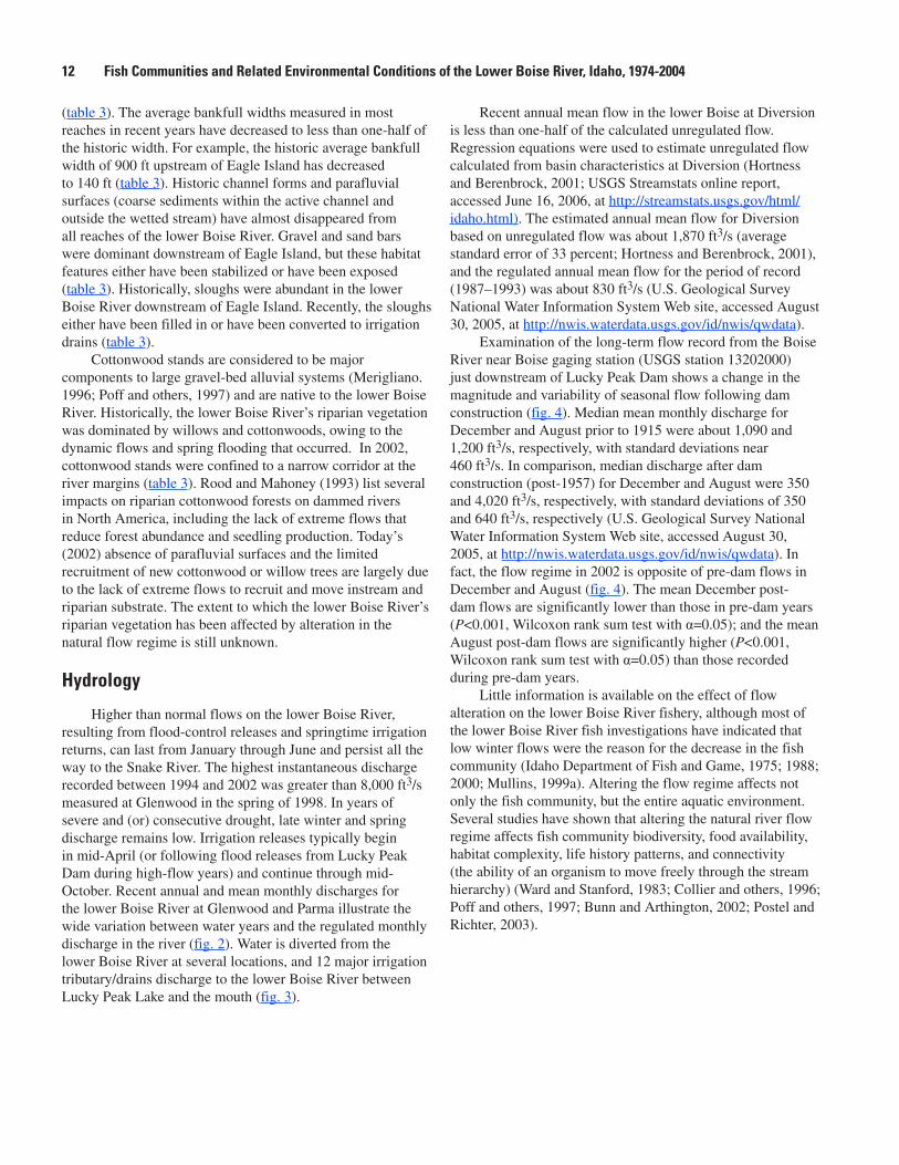
Higher than normal flows on the lower Boise River, resulting from flood-control releases and springtime irrigation returns, can last from January through June and persist all the way to the Snake River. The highest instantaneous discharge recorded between 1994 and 2002 was greater than 8,000 ft3/s measured at Glenwood in the spring of 1998. In years of severe and (or) consecutive drought, late winter and spring discharge remains low. Irrigation releases typically begin in mid-April (or following flood releases from Lucky Peak Dam during high-flow years) and continue through mid-October. Recent annual and mean monthly discharges for the lower Boise River at Glenwood and Parma illustrate the wide variation between water years and the regulated monthly discharge in the river (fig. 2). Water is diverted from the lower Boise River at several locations, and 12 major irrigation tributary/drains discharge to the lower Boise River between Lucky Peak Lake and the mouth (fig. 3).
Recent annual mean flow in the lower Boise at Diversion is less than one-half of the calculated unregulated flow. Regression equations were used to estimate unregulated flow calculated from basin characteristics at Diversion (Hortness and Berenbrock, 2001; USGS Streamstats online report, accessed June 16, 2006, at http://streamstats.usgs.gov/html/idaho.html). The estimated annual mean flow for Diversion based on unregulated flow was about 1,870 ft3/s (average standard error of 33 percent; Hortness and Berenbrock, 2001), and the regulated annual mean flow for the period of record (1987–1993) was about 830 ft3/s (U.S. Geological Survey National Water Information System Web site, accessed August 30, 2005, at http://nwis.waterdata.usgs.gov/id/nwis/qwdata).
Examination of the long-term flow record from the Boise River near Boise gaging station (USGS station 13202000) just downstream of Lucky Peak Dam shows a change in the magnitude and variability of seasonal flow following dam construction (fig. 4). Median mean monthly discharge for December and August prior to 1915 were about 1,090 and 1,200 ft3/s, respectively, with standard deviations near 460 ft3/s. In comparison, median discharge after dam construction (post-1957) for December and August were 350 and 4,020 ft3/s, respectively, with standard deviations of 350 and 640 ft3/s, respectively (U.S. Geological Survey National Water Information System Web site, accessed August 30, 2005, at http://nwis.waterdata.usgs.gov/id/nwis/qwdata). In fact, the flow regime in 2002 is opposite of pre-dam flows in December and August (fig. 4). The mean December post-dam flows are significantly lower than those in pre-dam years (P<0.001, Wilcoxon rank sum test with α=0.05); and the mean August post-dam flows are significantly higher (P<0.001, Wilcoxon rank sum test with α=0.05) than those recorded during pre-dam years.
Little information is available on the effect of flow alteration on the lower Boise River fishery, although most of the lower Boise River fish investigations have indicated that low winter flows were the reason for the decrease in the fish community (Idaho Department of Fish and Game, 1975; 1988; 2000; Mullins, 1999a). Altering the flow regime affects not only the fish community, but the entire aquatic environment. Several studies have shown that altering the natural river flow regime affects fish community biodiversity, food availability, habitat complexity, life history patterns, and connectivity (the ability of an organism to move freely through the stream hierarchy) (Ward and Stanford, 1983; Collier and others, 1996; Poff and others, 1997; Bunn and Arthington, 2002; Postel and Richter, 2003).
12 Fish Communities and Related Environmental Conditions of the Lower Boise River, Idaho, 1974-2004
Figure 2. Mean annual and mean monthly discharge rates for the Boise River recorded at the U.S. Geological Survey Glenwood Bridge near Boise, Idaho (13206000) and near Parma, Idaho (13213000) gaging stations.
(Discharge data for water years 1998-2001 from Idaho Power, 2002)
MEAN MONTHLY DISCHARGE, Boise River near Parma Water years 1994-2001
MEAN ANNUAL DISCHARGE, Boise River at Glenwood Bridge Recent period of record 1982-2001
MEAN ANNUAL DISCHARGE, Boise River near Parma Period of record 1972-1997
MEAN MONTHLY DISCHARGE, Boise River at Glenwood Bridge Water years 1994-2001
WATER YEARS
Fish Communities and Related Environmental Conditions 1�
id3093_figure03
EXPLANATION
Inflow
Outflow
USGS gaging station with number and name
River mileRM 58.8
RM 63.6
RM 58.8RM 58.3
RM 52.0
RM 51.0RM 50.4
RM 47.5
RM 38.0
RM 32.9RM 32.4
RM 29.1
RM 27.7RM 26.3
RM 24.7
RM 23.2RM 22.6
RM 22.4RM 21.9
RM 21.1
RM 19.7
RM 17.9RM 17.6
RM 16.0
RM 13.8
RM 3.8
RM 0.0
LuckyPeakLake
Snake River
13202000Boise River near Boise
13203510 Boise River below Diversion Dam
13206000Boise River at Glenwood Bridge
13210050Boise River near Middleton
13212500Boise River at Notus
13213000Boise River near Parma
Boise Project Main (New York) CanalPenitentiary Canal
Barber DamRidenbaugh Canal
Boise City Canal
Settlers Canal
Bubb, Meeves, #1 & #2, Rossi Mill
Drainage District #3Davis Ditch
Farmers Union and Boise Valley Canals
Lander Wastewater Treatment Facility
EagleIsland
9 EagleIslandCanals
New Dry Creek and New Union CanalsBallentine Canal
Eagle Drain
Little Pioneer CanalMiddleton Canal
West Boise Wastewater Treatment Facility
Thurman DrainEureka #1 and Phyllis Canals
Caldwell Wastewater Treatment Facility
Bowman and Swisher Canal
Caldwell Highline CanalCanyon Canal
Riverside and Pioneer Dixie Canals
Mill Slough below Grade Ditch
Fifteenmile CreekFivemile CreekTenmile Creek
Willow Creek
Mason Slough; Mason Creek
Hartley Drain and Gulch
Indian Creek
Sebree, Campbell, and Siebenburg Canals
Conway GulchBaxter and Boone Canals
Caldwell Bridge
McManus and Teater CanalsEureka #2 CanalUpper Center Point Canal
Lower Center Point Canal
Andrews DitchMammon Pumps
Parma Canal
Dixie DrainHaas Canal
Island Highland CanalMcConnel Island Canal
Figure �. Diversions, drains, and tributaries along the Boise River from Lucky Peak Lake to the Snake River, southwestern Idaho.(Modified from Warnick and Brockway, 1974).
14 Fish Communities and Related Environmental Conditions of the Lower Boise River, Idaho, 1974-2004
id3093_figure04
1890 1900 1920 1940 1960 1980 2000 20100
1,000
2,000
3,000
4,000
5,000
YEAR
1895 1916 1957 2002Pre-Impact Period Post-Impact Period
August
MEA
N M
ONTH
LY D
ISCH
ARGE
, IN
CUB
IC F
EET
PER
SECO
ND
0
500
1,000
1,500
2,000
2,500
December
75th percentile
median25th percentile
Figure 4. Mean monthly discharge for December and August recorded during pre- (1895–1916) and post-dam (1957–2002) periods at the U.S. Geological Survey Boise River near Boise gaging station (13202000), southwestern Idaho.
Water Quality
Recent water-quality data revealed longitudinal increases in constituent concentrations in the lower Boise (Mullins, 1998; MacCoy, 2004). Nitrogen, phosphorus, and suspended-sediment concentrations increased between Diversion and Parma (table 4). Increased agricultural activity in the lower basin appears to increase nutrient and sediment concentrations and is directly correlated with specific conductance. Urban land use also appears to increase nutrient concentrations in the lower Boise River. Maret (1997) found that specific conductance and percentage of fine sediment in streams and rivers of southern Idaho were highly correlated with agricultural land use. The suspended-sediment criterion of 80 mg/L for no more than 14 days (Rowe and others, 2003) was exceeded most frequently at the downstream-most site at Parma. Total nitrogen concentrations at Glenwood, Middleton, and Parma exceeded National background concentrations of 1.0 mg/L (U.S. Geological Survey, 1999). Middleton and Parma had more than twice the median flow-adjusted total nitrogen concentrations compared to undeveloped basins across the country (0.26 mg/L; Clark and others, 2000). Glenwood, Middleton, and Parma also exceeded the flow-adjusted total phosphorus concentrations for undeveloped basins (0.02 mg/L; Clark and others, 2000).
Table 4. Median, minimum, and maximum values of instantaneous water-quality measurements and select constituent concentrations from sites on the lower Boise River, southwestern Idaho, 1994–2002.
[Derived from MacCoy (2004). Subbasins shown in figure 1. Abbreviations: USGS, U.S. Geological Survey; ºC, degrees Celsius; mg/L, milligram per liter; μS/cm, microsiemen per centimeter; Min., minimum, Max., maximum]
Fish Communities and Related Environmental Conditions 1�
In natural stream environments, the temperature regime varies longitudinally and can be modified by land-management activities that influence channel width, riparian canopy cover, pool volume, runoff timing, and instream flow. Temperature has been an influential parameter in determining fish community structure (Poole and Berman, 2001; Poole and others, 2004), and it is vital to the understanding of the fish community in the lower Boise River. The State’s daily maximum temperature standards of 22°C and 13°C (Idaho Department of Environmental Quality, 2001) to protect cold water biota and salmonid spawning, respectively, were exceeded most frequently at Middleton and Parma (MacCoy, 2004). Continuous long-term monitoring of temperature is needed in the lower Boise River to monitor compliance with these standards. The City of Boise and the USGS began continuous temperature monitoring at selected sites on the lower Boise River in 2004 as part of a modeling effort; data from those monitoring efforts have not yet been published. For more information on the Idaho State water-quality standards for temperature refer to http://www.deq.idaho.gov/water/data_reports/surface_water/monitoring/temperature-index.cfm.
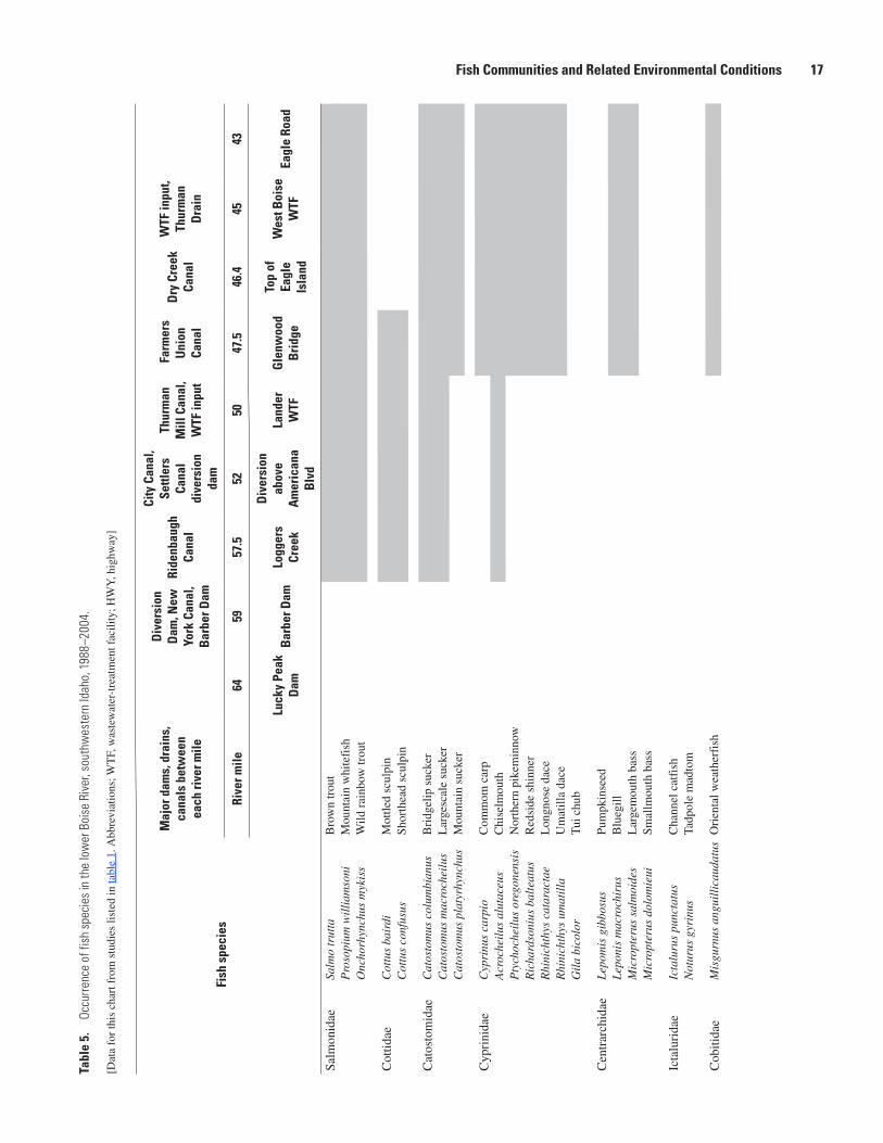
Occurrence and Status of Fish in the Lower Boise River
OccurrenceFish species that have been collected in
the lower Boise River from the studies listed in table 1 are summarized in appendix A. Table 5 summarizes the occurrence of each species by river mile from USGS and IDFG sampling events. All USGS data and only that from the first pass of the IDFG depletion sampling are summarized in appendix A and used in summary statistics. Water-quality and habitat conditions have changed in the basin since the first study was completed in 1974 by the IDFG. Therefore, the species listed for a given location in table 5 may not occur at that location today. For example, in 1988 and 1992, IDFG sampled common carp near Glenwood Bridge. Studies since that time have not found common carp at that site. The occurrence of fish species found near Middleton and near the mouth also is a result of only one sampling event at each USGS sampling site between 1995 and 1996 (table 1); a different community may occur at these sites today (2004).
Twenty-two species of fish distributed among 7 families have been identified in the lower Boise River: 3 Salmonidae (2 trout and 1 whitefish), 2 Cottidae (sculpins), 3 Catostomidae (suckers), 7 Cyprinidae (minnows), 4 Centrarchidae (sunfishes), 2 Ictaluridae (catfishes), and 1 Cobitidae (loach) (table 5).
Mountain whitefish (fig. 5) is the most widely distributed salmonid, having been collected from downstream of Barber Dam to the mouth. Brown trout (Salmo trutta, fig. 6) have been collected downstream of Barber Dam to Eagle Road Bridge; although rainbow trout (fig. 7) are the least distributed of the salmonids, having been collected downstream of Barber Dam to Middleton.
Fish Communities and Related Environmental Conditions 17
Fish
spe
cies
Maj
or d
ams,
dra
ins,
ca
nals
bet
wee
n ea
ch ri
ver m
ile
Dry
Cre
ek,
Mid
dlet
on
Cana
l, Ph
yllis
Ca
nal,
War
m
Spri
ngs
Cana
l
Phyl
lis C
anal
, W
arm
Spr
ings
Ca
nal
Cald
wel
l Hig
hlin
e Ca
nal,
Fifte
enm
ile
Cree
k, M
ill S
loug
h,
Will
ow C
reek
, M
ason
Cre
ek, N
oble
D
rain
, Not
us C
anal
Indi
an C
reek
, Co
nway
Gul
ch,
Eure
ka C
anal
, W
TF in
put
Dix
ie
Slou
gh
Rive
r mile
���4
�121
14�
�.�
2
B
otto
m E
agle
Is
land
Star
Mid
dlet
onH
WY
9�
at C
aldw
ell
Not
usH
WY
9�
near
Par
ma
Parm
a
gage
Fort
Boi
se
Nat
iona
l W
ildlif
e Re
fuge
Salm
onid
aeSa
lmo
trut
taB
row
n tr
out
Pro
sopi
um w
illi
amso
niM
ount
ain
whi
tefi
shO
ncho
rhyn
chus
myk
iss?
?W
ild r
ainb
ow tr
out
Cot
tidae
Cot
tus
bair
diM
ottle
d sc
ulpi
n
C
ottu
s co
nfus
usSh
orth
ead
scul
pin
Cat
osto
mid
aeC
atos
tom
us c
olum
bian
usB
ridg
elip
suc
ker
Cat
osto
mus
mac
roch
eilu
sL
arge
scal
e su
cker
Cat
osto
mus
pla
tyrh
ynch
usM
ount
ain
suck
er
Cyp
rini
dae
Cyp
rinu
s ca
rpio
Com
mom
car
pA
croc
heil
us a
luta
ceus
Chi
selm
outh
Pty
choc
heil
us o
rego
nens
isN
orth
ern
pike
min
now
Ric
hard
soni
us b
alte
atus
Red
side
shi
nner
Rhi
nich
thys
cat
arac
tae
Lon
gnos
e da
ceR
hini
chth
ys u
mat
illa
Um
atill
a da
ceG
ila
bico
lor
Tui
chu
b
Cen
trar
chid
aeL
epom
is g
ibbo
sus
Pum
pkin
seed
L
epon
is m
acro
chir
usB
lueg
ill
Mic
ropt
erus
sal
moi
des
Lar
gem
outh
bas
sM
icro
pter
us d
olom
ieui
Smal
lmou
th b
ass
Icta
luri
dae
Icta
luru
s pu
ncta
tus
Cha
nnel
cat
fish
N
otur
us g
yrin
usTa
dpol
e m
adto
m
Cob
itida
eM
isgu
rnus
an
guil
lica
udat
usO
rien
tal w
eath
erfi
sh
Tabl
e �.
Oc
curre
nce
of fi
sh s
peci
es in
the
low
er B
oise
Riv
er, s
outh
wes
tern
Idah
o, 1
988–
2004
.—Co
ntin
ued
[Dat
a fo
r th
is c
hart
fro
m s
tudi
es li
sted
in ta
ble
1. A
bbre
viat
ions
; WT
F, w
aste
wat
er-t
reat
men
t fac
ility
; HW
Y, h
ighw
ay]
1� Fish Communities and Related Environmental Conditions of the Lower Boise River, Idaho, 1974-2004
Both mottled (Cottus bairdi) and shorthead (Cottus confusus) sculpin (fig. 8) have been found only downstream of Barber Dam to Glenwood Bridge. Both largescale sucker (Catostomus macrocheilus, fig. 9) and bridgelip sucker (Catostomus columbianus, fig. 10) were found at all locations sampled, whereas mountain suckers (Catostomus platyrhynchus) were collected only from Glenwood Bridge to Middleton.
Most minnow species were widely distributed. Common carp, northern pikeminnow (Ptychocheilus oregonensis, fig. 11), redside shiner (Richardsonius balteatus), longnose dace (Rhinichthys cataractae) and Umatilla dace (Rhinichthys Umatilla) were found at all sampling sites from Glenwood Bridge to the mouth. One minnow, chiselmouth (Acrocheilus alutaceus), was collected at all sampling sites downstream of Barber Dam.
Of the sunfish, bluegill were found from Glenwood Bridge to Star, smallmouth bass (Micropterus dolomieu) (fig. 12) were found from Middleton to the mouth, and
largemouth bass were found from Glenwood Bridge to the mouth. Catfish were found in the lower reaches: channel catfish from Caldwell to the mouth, and tadpole madtom (Noturus gyrinus) from Star to Middleton.
The oriental weather fish (loach) is an invasive species that probably was introduced in the drains of the lower Boise River from tropical fish aquariums; it has been found from Glenwood to Middleton. The species is native to northeastern Asia and central China. They prefer still or slow-moving shallow waters in which they can burrow into the mud. They are tolerant to a wide range of water temperatures and conditions. For example, their ability to absorb oxygen from the air allows them to survive in water that is low in oxygen content. Moreover, the species has few predators and high production rates (Gulf States Marine Fisheries Commission: accessed March 2005, at http://nis.gsmfc.org/nis_factsheet.php?toc_id=192).
StatusFish metrics and the associated IBI scores have been
summarized in table 6 for reaches in the lower Boise River sampled during low-flow periods (November to April) and from least-disturbed rivers in southern Idaho. Sampling events for low-flow periods were chosen for IBI comparison to eliminate any sampling bias due to the inability to capture fish during high flows. Although all 10 metrics are similarly weighted, the occurrence of cold water species, sculpin, and common carp, or the occurrence of tolerant species, tended to drive the IBI scores either lower or higher. For example, the lack of sculpin species, as well as the decrease in cold water and sensitive species, decreased the overall IBI score. The occurrence of common carp at reach 3 in 1988 and 1992, and reaches 7 and 9 in 1996, also decreased the IBI scores. The percentage of anomalies also were highest at reach 3 in 2003, but this metric did not appear to have a profound effect on the IBI score.
IBI scores were higher for reaches 1 through 5 in 2003 (average IBI score of near 81) than in 1988 (average IBI score of near 62), which may indicate improved water-quality conditions in the upper reaches. The IBI scores from four least-disturbed sites ranged from 65 (intermediate biotic integrity) at the South Fork Snake River near Heise in 2003 to 99 (high biotic integrity) at the South Fork Payette River near Lowman in 2001. The median IBI score for all four least-disturbed sites was 81, indicating high biotic integrity (table 6). The dominant metrics driving the IBI scores at the least-disturbed sites were percentage of sculpin and cold water species. No carp were found at the least-disturbed sites, although tolerant individuals were found at all sites except the South Fork Payette River near Lowman.
Overall, the IBI scores for the lower Boise River (calculated since 1988, n=26, median of 67, intermediate biotic integrity) were lower than those for the least-disturbed sites. The IBI scores of 11 and 40 (indicating poor biotic integrity) at the Mouth and Middleton, respectively, were much lower than the scores at the least-disturbed sites. Additional sampling in the lower Boise River would be required to better characterize the biotic integrity of the system, particularly in the lower reaches where findings are based on a small number of samples.
Most IBI score classifications for sites with multiple years of data remained similar except for reach 3 (fig. 13). In this reach, IBI scores increased from 36 (poor biotic integrity) in 1988 to 73 (intermediate biotic integrity) in 2003. Median IBI scores calculated for reaches 1 and 2 sampled between 1988 and 2003 were greater than 75, indicating high biotic integrity, and for reaches 4 and 5 were near 60, indicating intermediate biotic integrity.
IBI scores were compared to some water-quality and habitat features measured between 1994 and 2002 (tables 3 and 4). Maximum instantaneous values of water temperature were negatively correlated with IBI scores (Spearman’s rank correlation coefficient >0.5, n=10, α=0.1). A significantly negative correlation was found between IBI scores and maximum instantaneous values of specific conductance and suspended sediment (Spearman’s rank correlation coefficient >0.80, n=10, α <0.5). Recent habitat measures such as embeddedness and bankful width were similar throughout the lower Boise River (table 3) and did not correlate well with IBI scores.
A dramatic longitudinal shift occurs in feeding groups from upstream to downstream in the lower Boise River (fig. 14, appendix A). Communities numerically dominated by piscivores (fish feeding on other fish) and invertivores (fish feeding on invertebrates), and those dominated by omnivores (fish feeding on both plant and animals) and herbivores (fish feeding on primarily plants) were compared between reaches for the samples collected in 1996. There was a decrease in piscivores and invertivores in reaches 3, 7, and 9. Only 20 percent of the fish species in reach 9 fed on macroinvertebrates or other fish. MacCoy (2004) found little difference in macroinvertebrate abundance from reach 1 to reach 9, but did identify differences in macroinvertebrate tolerance levels and feeding habits. In reach 1, the macroinvertebrate community consisted of only 2 percent tolerant species and was primarily filterers. Filterers spend most of their life cycle on the surface of coarse substrate, using specialized web and filtering mechanisms to feed on suspended detritus, and they are readily available for fish to consume (Voshell, 2002). The macroinvertebrate community in reach 9 consisted of near 50 percent tolerant species, and the community was primarily gatherers. Gatherers eat fine detritus that has fallen out of suspension and is located either on bottom sediment or between coarse substrate (Voshell, 2002). These species may not be readily available for fish to consume because they usually reside between course substrate or burrow into bottom sediment.
Subbasin areas were similar except for the upstream of Mouth subbasin that included an additional 1,000 mi2 of land (table 7). No significant correlation was found between basin area and IBI scores. However, specific land-use metrics calculated for each lower Boise River subbasin appear to correlate with IBI scores. Area of developed land, impervious surface area, and number of major diversions increased in a downstream direction (table 7) and had a significant negative correlation with IBI scores (Spearman rank correlation coefficient >0.9, n=7, α<0.05). Additional fish-community data in the downstream reaches would help to test the relation between land use and fish community.
20 Fish Communities and Related Environmental Conditions of the Lower Boise River, Idaho, 1974-2004
Tabl
e �.
Se
lect
ed m
etric
s an
d In
dex
of B
iolo
gica
l Int
egrit
y sc
ores
cal
cula
ted
for f
ish
sam
ples
col
lect
ed d
urin
g lo
w-fl
ow p
erio
ds (N
ovem
ber t
o Ap
ril) f
rom
the
low
er B
oise
Riv
er a
nd le
ast d
istu
rbed
site
s in
sou
thw
este
rn Id
aho.
[Rea
ch lo
catio
ns a
re s
how
n in
fig
ure
1 an
d ta
ble
2. D
ata
for
U.S
. Geo
logi
cal S
urve
y fi
sh s
ampl
es c
an b
e fo
und
onlin
e at
http
://id
.wat
er.u
sgs.
gov/
proj
ects
/fis
h/in
dex.
htm
l. R
each
: *, l
east
-dis
turb
ed s
ites.
A
bbre
viat
ions
: DE
LT, d
efor
miti
es, e
rode
d fi
ns, l
esio
ns, o
r tu
mor
s; N
D, n
o da
ta c
olle
cted
]
Reac
h N
o. o
r si
te n
ame
Mon
thYe
arN
umbe
r of
cold
nat
ive
spec
ies
Pe
rcen
tage
of
scu
lpin
Perc
enta
ge
of s
ensi
tive
nativ
e in
divi
dual
s
Perc
enta
ge
of c
old
indi
vidu
als
Perc
enta
ge
of t
oler
ant
indi
vidu
als
Num
ber
of n
on-
indi
gino
us
spec
ies
Pe
rcen
tage
of
car
p
Salm
onid
ag
e cl
asse
s (n
o w
hite
fish)
Cold
in
divi
dual
s pe
r min
ute
Pe
rcen
tage
of
DEL
T an
omol
ies
Inde
x of
B
iolo
gica
l In
tegr
ity
1Ja
n.19
883
222
799
10
3N
DN
D81
Dec
.19
964
5030
980
10
3N
DN
D89
Nov
.20
034
7980
971
10
515
093
2Ja
n.19
883
10
169
10
2N
DN
D54
Apr
.19
923
452
5613
10
25
ND
76M
ar.
1995
428
2159
110
0N
DN
DN
D92
Dec
.19
964
4514
7416
20
212
078
Nov
.20
035
4525
917
10
69
089
3Ja
n.19
883
10
635
31
ND
ND
ND
36M
ar.
1992
20
020
801
11
3N
D33
Feb.
1995
20
428
511
0N
D4
ND
48D
ec.
1996
42
231
481
02
20
57D
ec.
2001
48
377
162
02
122
68N
ov.
2003
515
469
262
03
43
734
Jan.
1988
31
567
311
06
ND
ND
70M
ar.
1992
20
343
531
05
3N
D55
Mar
.19
952
05
8317
10
ND
ND
ND
62D
ec.
1996
20
270
272
04
41
65N
ov.
2003
30
990
82
04
61
725
Jan.
1988
34
438
371
07
ND
ND
67M
ar.
1992
20
06
621
02
ND
ND
35Fe
b.19
952
06
4420
00
25
167
Dec
.19
962
09
8111
20
2N
D1
60N
ov.
2003
30
2784
162
05
5N
D77
7D
ec.
1996
20
026
282
8N
D3
139
9D
ec.
1996
10
08
802
20
02
11*H
enry
’s F
ork
Riv
er
near
St.
Ant
hony
Sept
.19
993
70
781
30
610
178
*Sou
th F
ork
Snak
e R
iver
nea
r H
eise
Sept
.20
033
210
8313
30
33
265
*Sou
th F
ork
Paye
tte
Riv
er n
ear
Low
man
July
2001
373
9192
00
04
30
99
*Boi
se R
iver
nea
r Tw
in S
prin
gsSe
pt.
2004
57
1946
350
05
20
84
Fish Communities and Related Environmental Conditions 21
Table 7. Subbasin areas, selected land-use metrics, and fish Index of Biotic Integrity scores for selected sampling events on the lower Boise River, southwestern Idaho, 2000–03.
[Subbasins and reach locations are shown in figure 1 and table 2. Subbasin area: including 2,690 mi2 upstream of Lucky Peak Dam. Abbreviations: WTF, wastewater- treatment facility; mi2, square mile; IBI, Index of Biotic Integrity]
Fish sampling reach No.
Fish sampling reach name SubbasinSubbasin
area (mi2)
2001 developed
land (mi2)
2000-01 impervious
surface (mi2)
2001 number of major
diversions
IBI score (year
sampled)
1 Downstream of Barber Dam Upstream of Eagle Island 2,710 0.12 1.70 5 93 (2003)2 Upstream of Lander WTF Upstream of Eagle Island 2,770 14.8 14.3 13 89 (2003)3 Downstream of Lander WTF 73 (2003)4 Upstream of West Boise WTF Upstream of Eagle Road 2,777 17.6 16.5 19 72 (2003)5 Downstream of West Boise WTF 77 (2003)7 Middleton Upstream of Middleton 2,894 27.5 25.8 31 39 (1996)9 Mouth Upstream of mouth 3,910 79.9 73.9 57 11 (1996)
Figure 1�. Fish index of biological integrity scores by year calculated for low-flow sampling events (November to April) in seven reaches of the lower Boise River, 1988–2003. (Reach numbers correspond to the reaches identified in figure 1 and table 2.)
id3093_figure13
Reach 9
0
20
40
60
80
1000
20
40
60
80
1000
20
40
60
80
1000
20
40
60
80
100
1988
1990
1992
1994
1996
1998
2000
2002
YEAR
1988
1990
1992
1994
1996
1998
2000
2002
Reach 7Reach 5
Reach 4Reach 3
Reach 2Reach 1
YEAR
FISH
INDE
X OF
BIO
LOGI
CAL
INTE
GRIT
Y SC
ORE
Figure 14. Percentages of invertivores and piscivores versus percentages of omnivores and herbivores derived from 1996 fish collections in the lower Boise River, southwestern Idaho.
id3093_figure14
Invertivores and piscivoresOmnivores and herbivores
REACH 9 RM 2
REACH 7 RM 31
REACH 5 RM 45.5
REACH 4 RM 46.5
REACH 3RM 47
REACH 2 RM 52
REACH 1 RM 59
0
20
40
60
80
100
PERC
ENTA
GE O
F TO
TAL
INDI
VIDU
ALS
22 Fish Communities and Related Environmental Conditions of the Lower Boise River, Idaho, 1974-2004
Fish Communities Upstream and Downstream of Wastewater-Treatment Facilities
Most of the fish-community data have been collected upstream and downstream of the Lander and West Boise WTFs (reaches 2 through 5; fig. 1). Data available for reaches 1 through 5 allowed for a more in-depth analysis of fish-community responses to water-quality and habitat variables. Table 6 provides individual metrics and IBI scores for sites upstream and downstream of WTFs.
The median IBI scores calculated from 1988 through 2003 at reaches 3 and 5 downstream of WTFs (53 and 67, respectively) were lower than reaches 2 and 4 upstream of the WTFs (78 and 65, respectively). Of the sites upstream and downstream of WTFs, the average IBI score upstream of Lander WTF, reach 2, was the only site with high biotic integrity (fig. 13). More tolerant fish species were found downstream of WTFs, with the average percentage of tolerant species increasing from reaches 2 to 3 (11 to 43 percent), and reaches 4 to 5 (27 to 29 percent). The difference in tolerant species between reaches 4 and 5 was small and these sites are considered to support similar fish communities. The average percentage of cold water species decreased from reach 2 to 3 (from 59 to 38 percent) and from reach 4 to 5 (from 71 to 50 percent). Percentage of sculpin had the most dramatic longitudinal decrease for an individual metric. The average (1988–2003) percentage of sculpin in reach 1 was close to 50 percent of the fish community and decreased to an average of 33 percent in reach 2 and decreased even further to an average of 4 percent in reach 3. Sculpin have not been found since 1988 at reaches 4 and 5, and were found in very low numbers. The decrease in the sculpin population in the downstream reaches may be a factor of a combination of habitat loss, predation, and water-quality degradation. There was an increase in percentage of sculpin between 1988 and 2003 in reach 3 that suggests a slight improved water quality (fig. 15). There also was an increase in the IBI score in reach 3 from 36 (poor biotic integrity) in 1988 to 73 (intermediate biotic integrity) in 2003. The City of Boise changed from chlorination/declorination treatment of wastewater to ultraviolet treatment at the Lander WTF in 1995 (Robbin Finch, City of Boise, written commun., 2003), which may have had an impact on the sculpin population. Sculpin were not found in the downstream Lander WTF sample in August 2004 (appendix A). Previous samples from this reach were taken during low-flow periods (December to March) suggesting that sculpin may have flow or seasonal preferences in habitat. Although similar changes to wastewater treatment were made at the West Boise WTF in 2000, sculpin have not been found upstream or downstream of this facility.
Sculpin and other benthic small-bodied fish have been used as sentinel species for environmental monitoring because they may be sensitive to chemical or other stressors. They are
not subject to fishing harvest and stocking which confound the analyses of game fish. Sculpin have a limited home range (less than 50 m and respond to local conditions (Brown and Downhower, 1982; Gray, 2004; Petty and Grossman, 2004). In contrast, the home range of large-bodied fish such as suckers or mountain whitefish can be more than 50 km making it difficult to relate exposure to responses (Pettit and Wallace, 1975; Baxter, 2002).
Analysis of Mountain Whitefish Condition
Mountain whitefish comprise a large portion of the fish biomass in the lower Boise River. The species has been classified as a cold water native, but it is intermediate in its sensitivity to degraded water-quality conditions such as siltation, elevated temperatures, and low dissolved-oxygen concentrations (Zaroban and others, 1999). Several studies have documented the adverse effects of elevated summer temperatures and suspended sediment on mountain whitefish. For example, in laboratory experiments with adult fish, increasing lethality was observed at temperatures greater than about 23ºC (Ihnat and Buckley, 1984). In July 2002, a large kill of mountain whitefish occurred in the Snake River near Waters Ferry, Idaho, following several days during which the maximum daily temperatures in the river exceeded 26ºC (Idaho Department of Environmental Quality, 2003). Mountain whitefish also showed avoidance behavior and gill damage following exposures to elevated suspended sediments during a sluicing operation in Wyoming in which sediment concentrations increased to 500 times the background concentration (Bergsted and Bergersen, 1997). In contrast, when exposed to elevated concentrations of suspended sediment that were within the natural range in an Alberta River, mountain whitefish showed no avoidance behavior (Reid and others, 2002).
id3093_figure15
Upstream, reach 2Downstream, reach 3
0
10
20
30
40
50
1988 1992 1995 1996 2001 2003
PERC
ENTA
GE O
F SC
ULPI
N
SELECTED YEAR OF DATA ANALYSIS
Figure 1�. Changes in the occurrence of sculpin upstream and downstream of Lander Wastewater Treatment Facility, lower Boise River, southwestern Idaho, 1988–2003.
Fish Communities and Related Environmental Conditions 2�
Because lower Boise River mountain whitefish are somewhat sensitive to degraded water quality and account for a large portion of the fish biomass, additional analyses of length and weight data were made to determine the relative “health” of the population. The relation of mountain whitefish length and weight observed in the lower Boise River from sites upstream of Middleton is compared to those from least-disturbed rivers in southern Idaho and to mountain whitefish collected from throughout their natural range in the northern United States and Canada (Rogers and others, 1996) to give a relative “condition” of individual fish. Condition indexes or standard weight equations are considered most representative if they are developed by using a large portion of the population across the geographical range (Murphy and others, 1991). Rogers and others (1996) developed a North American standard weight equation for mountain whitefish using more than 13,000 fish from their range in the northern United States
and two Canadian provinces. Condition equations were developed from the lower Boise River and least-disturbed rivers using regression analysis of log-transformed mountain whitefish total lengths and weights (fig. 16). The lower Boise River equation (log . . log10 105 624 3 229W L= + )was very similar to both the North American standard equation (log . . log10 105 086 3 036W L= + ) and the least-disturbed site equation (log . . log10 104 057 2 623W L= - + ). Lower Boise River mountain whitefish appear to be slightly smaller than those from the least-disturbed sites in southern Idaho (fig. 17). Based on their abundance and their relative weight, the general condition of the mountain whitefish in the lower Boise River appears to be high, although mountain whitefish are uncommon downstream of Middleton. Possible factors that may limit mountain whitefish populations in the downstream reaches include water-quality conditions such as high temperatures and increased siltation.
id3093_figure16
Least disturbed streams
North American standard equation
Lower Boise River
Least disturbed streams
LOG10 VALUE OF MOUNTAIN WHITEFISH LENGTH, IN MILLIMETERS
LOG
10 V
ALU
E O
F M
OU
NTA
IN W
HIT
EFIS
H W
EIG
HT,
IN G
RA
MS
1
1.5
2
2.5
3
2.1 2.2 2.3 2.4 2.5 2.6
Figure 1�. Comparison of relative weight equations calculated for mountain whitefish collected from the lower Boise River with the North American standard weight equation for mountain whitefish and measurements from least-disturbed rivers in southern Idaho.North American standard weight equation for mountain whitefish from Rogers and others (1996).
24 Fish Communities and Related Environmental Conditions of the Lower Boise River, Idaho, 1974-2004
Data Limitations and Potential Future Investigations
Based on several metrics and an overall IBI of the lower Boise River, the fish community upstream of the Lander WTF is similar to that of least-disturbed rivers in southern Idaho. Downstream of the Lander WTF, the apparent range expansion of sculpin over the last decade may indicate long-term improvements in water quality. However, important limitations apply to the analysis of this limited dataset. The main analytical tools, an IBI model to evaluate the overall fish community and relative weight equations to evaluate fish community “health,” are useful but crude in their predictive power to asses the effect of pollutants on the fish population.
Future assessments of status or changes in fish community and health in the lower Boise River would benefit from more robust assessments of the distribution of benthic species such as sculpin and direct assessment of fish health. Measures related to energy expenditure, energy storage, and survival of fish populations can be obtained with little
additional effort (Munkittrick and McMaster, 2000). Measures of bioaccumulation and biomarkers of chemical exposure can be important measures for waters that receive complex point and non-point discharges. These measures have been successfully used in the monitoring and assessment of fish health in rivers receiving organic effluents and in targeting similar species found in the lower Boise River (Kloepper-Sams and others, 1994a, 1994b; Swanson and others, 1994; Gibbons and others, 1998).
Recent studies have shown that rivers receiving urban and agricultural effluent, such as the lower Boise River, may be influenced by wastewater chemicals that include detergents, disinfectants, fragrances, fire retardants, nonprescription drugs, and pesticides (Barnes and others, 2002; Kolpin and others, 2002; Sprague and Battaglin, 2004). Some of these chemicals may mimic hormones, causing effects in fish that may not be obvious in conventional monitoring, such as reduced reproductive health or reduced defense against disease (Thorpe and others, 2001; van der Oost and others, 2003; Brown and others, 2004). Three sites on the lower Boise River (downstream of Diversion Dam, upstream of
id3093_figure17
Lower Boise Rivery = 0.000002x3.23
R2 = 0.98N = 2306
Least-disturbed sitesy = 0.00009x2.63
R2 = 0.93N = 154
0
100
200
300
400
500
600
100 150 200 250 300 350 400
LENGTH, IN MILLIMETERS
WEI
GHT,
IN G
RAM
S
Figure 17. Mountain whitefish length and weight relations for the lower Boise River and least-disturbed sites in southern Idaho, 1988–2004.
Data Limitations and Potential Future Investigations 2�
Middleton, and downstream of Parma) were selected as part of a national assessment of wastewater chemicals (Barnes and others, 2002). Results of this study found no antibiotics or human pharmaceutical compounds at these sites in water but did detect hormones and other organic wastewater chemicals. Bioaccumulation of these chemicals is unknown in the lower Boise River. Preliminary results of a recent USGS study have identified these types of chemicals in Colorado streams (Sprague and Battaglin, 2004) and have indicated their potential endocrine disruption effects on fish. The USGS conducted a reconnaissance of endocrine-disrupting compounds in rivers across the United States and concluded that sites containing these compounds may affect the endocrine system of resident fish (Goodbred and others, 1997). In a survey of fish contamination in the Columbia River, mountain whitefish tended to have higher concentrations of mercury and some pesticides than did other fish (U.S. Environmental Protection Agency, 2002). This finding suggests that different species also may have different uptake rates and reactions to pollutants. Considering the above factors, a more comprehensive evaluation of fish health that includes both indicators of exposure and potential effects of endocrine-disrupting chemicals could provide important information about the effects of pollutants on fish populations in the lower Boise River.
SummaryWithin the last century, the lower Boise River
downstream of Lucky Peak Dam in southwestern Idaho has been transformed from a meandering, braided, gravel-bed river that supported large runs of salmon to a channelized, regulated, urban river that provides flood control and irrigation water to more than 1,200 square miles of land. In some places, the river is one-half the width it was before it was dammed. The lower Boise River fish communities are impacted by flow alterations, habitat loss, and poor water quality. As water demand increases for urban, domestic, and agricultural uses, so does the impact on the fish communities. The river’s flow is regulated by upstream dams and downstream irrigation returns. In fact, the current flow in the lower Boise River is opposite to that of pre-dam era, with lower flows in the winter and higher flows in the summer. The lack of higher flows to recruit and move gravel for riffle habitat and to mobilize fine sediment has caused embeddedness throughout the river that measures between 50 and 75 percent. The quality of water decreases in a downstream direction with increasing temperatures and nutrient and sediment concentrations. Although rainbow trout are stocked at a rate of 56,000 fish per year in the lower Boise River, the lack of colder temperatures downstream has reduced natural spawning of this species.
Fish data from the U.S. Geological Survey (USGS) and Idaho Department of Fish and Game (IDFG) collected since 1974 were combined to report the status of fish communities in the lower Boise River. Twenty-two species representing 7 families of fish have been identified in the lower Boise River: 3 salmonids (trout and whitefish), 2 cottids (sculpins), 3 catostomids (suckers), 7 cyprinids (minnows), 4 centrarchids (sunfish), 2 ictalurids (catfish), and one cobitidae (loach). Of these, 13 are native species, 5 are cold water species, 9 are cool water species, and 8 are warm water species. Most of the warm water species are found in the lower reaches of the river. Of the salmonid species, mountain whitefish have been found throughout the lower Boise River, and rainbow and brown trout have been found upstream of Eagle Road. Sculpin, a cold water, bottom-feeding fish, has been found only in the upstream reaches upstream of Glenwood Bridge. Suckers have been found throughout the river, and tolerant species such as carp, northern pikeminnow, bass, and catfish have been found primarily in the lower reaches. Index of Biotic Integrity (IBI) scores calculated for USGS and IDFG sampling events between 1988 and 2004 decreased in a downstream direction, with two of the lowest scores (indicating poor biotic integrity) measured at Middleton (40) and near the mouth (11), respectively. IBI scores for each sampling reach remained similar over time except for the reach downstream of the Lander WTF. The IBI scores for the reach downstream of the Lander WTF (reach 5) increased from a score of 36 in 1988, indicating poor biotic integrity, to 73 in 2003, indicating intermediate biotic integrity. The increase in IBI score at this site may be an indication of increased water quality and reflects the increased number of sculpin found in 2003. IBI scores for all sites were negatively correlated with maximum instantaneous water temperature, specific conductance, and suspended sediment; as well as the basin land-use metrics of area of developed land, impervious surface area, and number of major diversions within a subbasin. Fish communities downstream of Middleton consisted primarily of tolerant species and omnivorous feeders, whereas fish communities in the upstream most reach downstream of Barber Dam consist of only 2 percent tolerant species and were piscivores and invertivores.
Fish communities downstream of the Lander WTF generally had lower IBI scores, an increase in tolerant species, and a decrease in percentage of cold water species. Sculpin were not found downstream of Glenwood Bridge in the lower Boise River, possibly due to decreases in habitat and water quality. Length-weight relations for mountain whitefish, an indicator used to determine the condition of the species’ population in the lower Boise River, were similar to those found both in regional populations and in least-disturbed rivers in southern Idaho.
2� Fish Communities and Related Environmental Conditions of the Lower Boise River, Idaho, 1974-2004
The fish communities in the lower Boise River have changed in response to changes in habitat, land use, and water quality. As the human population increases in the lower Boise River Basin, the demand for both high-quality water and recreation in and around the river will affect aquatic communities, especially fish communities. Frequent and comprehensive monitoring of the lower Boise River fish communities will help to identify impacts and to sustain this beneficial resource.
Land use in the lower Boise River Basin is changing rapidly from a rural/agricultural community to an urban/residential community, and these changes may affect the lower Boise River fish community. Future assessments of status or changes in fish community and health in the lower Boise River should focus on the distribution of benthic species such as sculpin and the direct assessment of fish health. A more comprehensive evaluation of fish health that includes both indicators of exposure and potential effects of endocrine-disrupting chemicals could provide important information about the effects of pollutants on fish populations in the lower Boise River.
AcknowledgmentsThe author would like to thank Jeff Dillon of the Idaho
Department of Fish and Game (IDFG) for providing data and technical input for this report. Technical reviews by Karen Murray, Chris Mebane, and Terry Maret of the U.S. Geological Survey (USGS) greatly improved the quality of this report. Thank you to all of the USGS, IDFG, City of Boise, and Idaho Department of Environmental Quality personnel who helped with fish collection and data analysis.
References CitedArmour, C.L., Burnham, K.P., and Platts, W.S., 1983, Field
methods and statistical analysis for monitoring small salmonid streams: U.S. Fish and Wildlife Service, Western Energy and Land Use Team, Division of Biological Services, Research and Development, Washington, D.C., 200 p.
Asbridge, G., and Bjornn, T.C., 1988, Survey of potential and available salmonid habitat in the lower Boise River: Idaho Department of Fish and Game job completion report, project F-71-R-12, subproject 3, job no. 3, 71 p.
Baker, V., 1994, Geomorphological understanding of floods: Geomorphology, v. 10, p. 139-156.
Barnes, K.K., Kolpin, D.W., Meyer, M.T., Thurman, E.M., Furlong, E.T., Zaugg, S.D., and Barber, L.B., 2002, Water-quality data for pharmaceuticals, hormones, and other organic wastewater contaminants in U.S. streams, 1999-2000: U.S. Geological Survey Open-File Report 02-94, 7 p.
Baxter, C.V., 2002, Fish movement and assemblage dynamics in a Pacific Northwest riverscape: Corvallis, Oregon State University, Ph.D dissertation, 188 p.
Bayley, P.B., 1991, The flood pulse advantage and the restoration of river-floodplain systems, Regulated Rivers: Research and Management, v. 6, p. 75-86.
Benke, R.J., 1992. Native trout of western North America: American Fisheries Society Monograph 6: American Fisheries Society, Bethesda, Maryland, 275 p.
Bergsted, L.C., and Bergersen, E.E., 1997, Health and movements of fish in response to sediment sluicing in the Wind River, Wyoming: Canadian Journal of Fisheries and Aquatic Sciences, v. 54, no. 2, p. 312-319.
Bravard, J.P., Landonn N., Peiry, J.L., and Piegay, H., 1999, Principles of engineering geomorphology for managing channel erosion and bedload transport, examples from French rivers: Geomorphology v. 31, p. 291-311.
Brookes, A., 1996, River channel change, in Petts, G., and Calow, P., eds., River flows and channel forms: Blackwell Science Ltd. Oxford, United Kingdom, p. 221–242.
Brown, A.R., Riddle, A.M., Cunningham, L.L., Kedwards, T.J., Shillabeer, N., and Hutchinson, T.H., 2004, Predicting the effects of endocrine disrupting chemicals on fish populations: Human and Ecological Risk Assessment, v. 9, no. 3, p. 761-788.
Brown, L.P., and Downhower, J.F., 1982, Summer movements of mottled sculpins, Cottus bairdi (Pisces: Cottidae): Copeia, v. 2, p. 450-455.
Bunn, S.E., and Arthington, A.H., 2002, Basic principles and ecological consequences of altered flow regimes for aquatic biodiversity: Environmental Management, v. 30, no. 4, p. 492-507.
Casey, O.E., and Webb, W.E., 1960, Federal aid in fish restoration, annual progress report, water-quality investigations: State of Idaho, Department of Fish and Game, 59 p.
Chandler, J.A., and Chapman, D., 2001, Existing habitat conditions of tributaries formerly used by anadromous fish, in Chandler, J.A., ed., Feasibility of reintroduction of anadromous fish above or within the Hells Canyon Complex: Boise, Idaho, Idaho Power Company, p. 40-48, accessed October 2004, at http://www.idahopower.com/riversrec/relicensing/hellscanyon/hellspdfs/techappendices/list_techappend.pdf.
Clark, G.M., 1994, Assessment of selected constituents in surface water of the upper Snake River Basin, Idaho and Western Wyoming, water years 1975-89: U.S. Geological Survey Water-Resources Investigations Report 93-4229, 49 p.
Clark, G.M., Mueller, D.K., and Mast, M.A., 2000, Nutrient concentrations and yields in undeveloped stream basins of the United States: Journal of the American Water Resources Association, v. 36, no. 4, p. 849-860.
Collier, M., Webb, R.H., and Schmidt, J.C., 1996, Dams and rivers: A primer on the downstream effects of dams: U.S. Geological Survey Circular 1126, 94 p.
Frenzel, S.A., 1988, Physical, chemical, and biological characteristics of the Boise River from Veterans Memorial Parkway, Boise to Star, Idaho, October 1987 to March 1988: U.S. Geological Survey Water-Resources Investigations Report 88-4206, 48 p.
Frenzel, S.A., 1990, Effects of municipal wastewater discharges on aquatic communities, Boise River, Idaho: Water Resources Bulletin, v. 26, no. 2, p. 279-287.
Frenzel, S.A., and Hansen, T.F., 1988, Water-quality data for the Boise River, Boise to Star, Idaho, January to March 1988: U.S. Geological Survey Open-File Report 88-474, 14 p.
Fuller, P.L., Nico, L.G., and Williams, J.D., 1999, Nonindigenous fishes introduced into inland waters of the United States: American Fisheries Society Special Publication 27, Bethesda, Maryland, 613 p.
Gibbons, W.N., Munkittrick, K.R., and Taylor, W.D., 1998, Monitoring aquatic environments receiving industrial effluent using small fish species 1: response of spoonhead sculpin (Cottus ricei) downstream from a bleached-kraft pulp mill: Environmental Toxicology and Chemistry, v. 17, no. 11, p. 2227–2237.
Gilvear, D.J., 1993, River management and conservation issues on formerly braided river systems: the case of the River Tay, Scotland, in Best, J.L., and Bristow, C.S., eds., Braided rivers: Geological Society Special Publication 75, Oxford, United Kingdom, p. 231-240.
Gilvear, D.J., and Winterbottom, S.J., 1992, Channel change and flood events since 1783 on the regulated River Tay, Scotland: implications for flood hazard management, Regulated Rivers: Research and Management v. 7, p. 247-260.
Goodbred, S.L., Gilliom, R.J., Gross, T.S., Denslow, N.P., Bryant, W.L., and Schoeb, T.R., 1997, Reconnaissance of 17ß-Estradiol, 11-Ketotestosterone, Vitellogenin, and gonad histopathology in common carp of United States streams: Potential for contaminant-induced endocrine disruption: U.S. Geological Survey Open-File Report 96-627, 47 p.
Gulf States Marine Fisheries Commission, 2003, Misgurnus anguillicaudatus, accessed March 2005, at http://nis.gsmfc.org/nis_factsheet.php?toc_id=192.
Grafe, C.S., ed., 2002, Idaho rivers ecological assessment framework—an integrated approach: Idaho Department of Environmental Quality, Boise, Idaho.
Gray, M.A., 2004, Site fidelity of slimy sculpin (Cottus cognatus): insights from stable carbon and nitrogen analysis: Canadian Journal of Fisheries and Aquatic Sciences, v. 61, no. 9, p. 1717-1722.
Heede, B.H., and Rinne. J.N., 1990, Hydrodynamic and fluvial morphologic processes: implications for fisheries management and research: North American Journal of Fisheries Management, v. 10, p. 249-268.
Hortness, J.E., and Berenbrock, C., 2001, Estimating monthly and annual streamflow statistics at ungaged sites in Idaho: U.S. Geological Survey Water-Resources Investigations Report 01-4093, 36 p.
Hortness, J.E., and Werner, D.C., 1999, Stream channel cross sections for a reach of the Boise River in Ada County, Idaho: U.S. Geological Survey Open-File Report 99-211, 100 p.
Idaho Department of Environmental Quality, 1999, Lower Boise River TMDL, sub-basin assessment, total maximum daily loads: Boise, Idaho State Department of Environmental Quality, 82 p.
Idaho Department of Environmental Quality, 2001, Water quality standards and wastewater treatment requirements, 58.01.02, accessed June 16, 2006, at http://adm.idaho.gov/adminrules/rules/idapa58/0102.pdf.
Idaho Department of Environmental Quality, 2003, Mid Snake River/Succor Creek sub-basin assessment and total maximum daily load: Idaho Department of Environmental Quality. 442 p., accessed June 16, 2006, at http://www.deq.idaho.gov/water/data_reports/surface_water/tmdls/sba_tmdl_master_list.cfm.
Idaho Department of Fish and Game, 1975, Survey of fish population and water quality in the Boise River from its mouth upstream to Barber Dam, March 1, 1974 – February 28, 1975: Snake River Fisheries Investigations, job performance report, Project F-63-R-4, 64 p.
Idaho Department of Fish and Game, 1988, Region 3 (Boise) stream investigation–Boise River, January 1, 1988-March 21, 1988: Regional fishery management investigation, job performance report, p. 111-135.
Idaho Department of Fish and Game, 2000, Boise River, City of Boise sampling sites, November and December 1993 and March 1994: Regional fishery management investigation, job performance report, Program F-71-R-19, p. 88-104.
Ihnat, J.M., and Buckley, R.V., 1984, Influences of acclimation temperature and season on acute temperature preference of adult mountain whitefish, Prosopium williamsoni: Environmental Biology of Fishes, v. 11, no. 1, p. 29-40.
Karr, J. R., 1991, Biological integrity: A long-neglected aspect of water resource management: Ecological Applications v. 1, p. 66-84.
2� Fish Communities and Related Environmental Conditions of the Lower Boise River, Idaho, 1974-2004
Kloepper-Sams, P.J., Swanson, S.M., Marchant, T., Schryer, R., and Owens, J.W., 1994a, Exposure of fish to biologically treated bleached-kraft effluent, 1. Biochemical, physiological and pathological assessment of Rocky Mountain whitefish (Prosopium williamsoni) and longnose sucker (Catostomus catostomus): Environmental Toxicology and Chemistry, v. 13, no. 9, p. 1469-1482.
Kloepper-Sams, P.J., Swanson, S.M., Marchant, T., Schryer, R., and Owens, J.W., 1994b, Exposure of fish to biologically treated bleached-kraft effluent, 2. Induction of hepatic cytochrome P4501A in mountain whitefish (Prosopium williamsoni) and other species: Environmental Toxicology and Chemistry, v. 13, no. 9, p. 1483-1496.
Koberg, S., and Griswold, K., 2001, Draft Lower Boise River TMDL implementation plan for agriculture: Idaho Soil Conservation Commission, 34 p. plus app.
Kolpin, D.W., Furlong, E.T., Meyer, M.T., Thurman, E.M., Zaugg, S.D., Barber, L.B., and Buxton, H.T., 2002, Pharmaceuticals, hormones, and other organic wastewater contaminants in U.S. streams, 1999-2000—A national reconnaissance: Environmental Science and Technology, v. 36, no. 6, p. 1202-1211.
Kramer, W.J., Morse, A., Harmon, B., and Anderson, H., 1994, Mapping 80 years of change in irrigated agriculture: Boise, Idaho Department of Water Resources, 5 p. plus GIS coverages.
Li, H.W., Schreck, C.B., Bond, C.E., and Rexstad, E., 1987, Factors influencing changes in fish assemblages of Pacific Northwest streams, in Mathews, W.J., and Heins, D.C., eds.: Community and Evolutionary Ecology of North American Stream Fishes, University of Oklahoma Press, Norman, Oklahoma, p. 193-240.
Love, S.K., and Benedict, P.C., 1940, Discharge and sediment loads in the Boise River Drainage Basin, Idaho, 1939-1940: U.S. Department of Interior, Geological Survey, prepared in cooperation with the Flood Control Coordinating Committee, U.S. Department of Agriculture, Washington, DC, 55 p. plus apps.
MacCoy, D.E., 2004, Water-quality and biological conditions in the lower Boise River, Ada and Canyon Counties, Idaho, 1994-2002: U.S. Geological Survey Scientific-Investigations Report 2004-2158, 80 p.
MacCoy, D.E., and Blew, D., 2005, Impacts of land-usechanges and hydrologic modification on the lower Boise River, Idaho, USA: Affects of Urbanization on Ecosystems, American Fisheries Society Symposium 47, p. 133-156.
Maret, T.R., 1997, Characteristics of fish assemblages and related environmental variables for streams of the Upper Snake River Basin, Idaho and Western Wyoming, 1993-95: U.S. Geological Survey Water-Resources Investigations Report 97-4087, 50 p.
Maret, T.R., MacCoy, D.E., Skinner, K.D., Moore, S.E., and O’Dell, I., 2001, Evaluation of macroinvertebrate assemblages in Idaho rivers using multimetric and multivariate techniques, 1996-98: U.S. Geological Survey Water-Resources Investigations Report 01-4145, 69 p.
Maret, T.R., and Ott, D.S., 2003, Assessment of fish assemblages and minimum sampling effort required to determine biotic integrity of large river in southern Idaho, 2002: U.S. Geological Survey Water-Resources Investigations Report 03-4274, 16 p.
McDowell, P.F., 2000, Human impacts and river channel adjustment, Northeastern Oregon: implications for restoration, in Wigington, P.J., and Beschta, R.L., eds.: Riparian ecology and management in multi-land use watersheds symposium proceedings, American Water Resources Association, Middleburg, Virginia, p. 257-261.
Meador, M.R., Cuffney, T.F., and Gurtz, M.E., 1993, Methods for sampling fish communities as part of the National Water-Quality Assessment Program: U.S. Geological Survey Open-File Report 93-104, 40 p.
Mebane, C.A., Maret, T.R., and Hughes, R.M., 2003, An index of biological integrity (IBI) for Pacific Northwest rivers: Transactions of the American Fisheries Society, v. 132, no. 2, p. 234-261.
Merigliano, M.F., 1996, Ecology and management of the South Fork Snake River cottonwood forest: Idaho Bureau of Land Management Technical Bulletin 96-9, 79 p., 17 pls.
Mullins, W.H., 1998, Water-quality conditions of the lower Boise River, Ada and Canyon Counties, Idaho, May 1994 through February 1997: U.S. Geological Survey Water-Resources Investigations Report 98-4111, 32 p.
Mullins, W.H., 1999a, Biological assessment of the lower Boise River, October 1995 through January 1998, Ada and Canyon Counties, Idaho: U.S. Geological Survey Water-Resources Investigations Report 99-4178, 37 p.
Mullins, W.H., 1999b, Biotic integrity of the Boise River upstream and downstream from two municipal wastewater treatment facilities, Boise, Idaho, 1995-96: U.S. Geological Survey Water-Resources Investigations Report 98-4123, 17 p.
Munkittrick, K.R., and McMaster, M.E., 2000, Effects-driven assessment of multiple stressors using fish populations, in Ferenc, S.A., and Foran, J.A., eds., Multiple stressors in ecological risk and impact assessment: approaches to risk estimation: Pensacola, Florida, Society of Environmental Toxicology and Chemistry, SETAC Press, p. 27-66.
Murphy, B.R., Willis, D.W., and Springer, T.A., 1991, The relative weight index in fisheries management—Status and needs: Fisheries, v. 16, no. 2, p. 30-38.
Nature Conservancy (The), 2001, Indicators of hydrologic alteration, user’s manual with Smythe Scientific software: The Nature Conservancy, July 2001, 31 p.
Nelson, J.S., Crossman, E.J., Espinosa-Perez, H., Findley, L.T., Gilbert, C.R., Lea, R.N., and Williams, J.D., 2004, Common and scientific names of fishes from the United States, Canada, and Mexico, sixth edition: American Fisheries Society Special Publication 29, Bethesda, Maryland, 253 p. plus app.
References Cited 29
Peck, D.V., Averill, D.K., Lazorchak, J.M., and Klemm, D.J., eds., 2002, Environmental monitoring and assessment program-surface waters: western pilot study: field operations manual for non-wadeable rivers and streams (Draft): U.S. Environmental Protection Agency, Corvallis, Oregon, 198 p.
Pettit, S.W., and Wallace, R.L., 1975, Age, growth, and movement of mountain whitefish, Prosopium williamsoni (Girard), in the North Fork Clearwater River, Idaho: Transactions of the American Fisheries Society, v. 104, no. 1, p. 68-76.
Petty, J.T., and Grossman, G.D., 2004, Restricted movement by mottled sculpin (pisces:cottidae) in a southern Appalachian stream: Freshwater Biology, v. 49, no. 5, p. 631-645.
Poff, N.L., Allan, J.D., Bain, M.B., Karr, J.R., Prestegaard, K.L., Richter, B.D., Sparks, R.E., and Stromberg. J.C., 1997. The natural flow regime: paradigm for river conservation and restoration: BioScience, v. 47, p. 769-784.
Poole, G.C., and Berman, C.H., 2001, An ecological perspective on in-stream temperature: natural heat dynamics and mechanisms of human-caused thermal degradation: Environmental Management, v. 27, no. 6, p. 787-802.
Poole, G.C., Dunham, J.B., Keenan, D.M., Sauter, S.T., McCullough, D.A., Mebane, C.A., Lockwood, J.C., Essig, D.A., Hicks, M.P., Sturdevant, D.J., Materna, E.J., Spalding, S.A., Risley, J.C., and Deppman, M., 2004, The case for regime-based water-quality standards: BioScience, v. 54, no. 2, p. 155-161.
Postel, S., and Richter, B., 2003, Rivers for Life: Managing waters for people and nature: Island Press, Washington, DC, 254 p.
Pratt, K.L., Kozel, M., Mauser, J., Mauser, L. and Sarpella, R., 2001, Annotated bibliographies on the chronology of decline of anadromous fish in the Snake River Basin above the Hells Canyon Dam, in Chandler, J.A., ed., Chapter 4, Feasibility of reintroduction of anadromous fish above or within the Hells Canyon Complex: Boise, Idaho Power Company, Technical appendices for Hells Canyon Complex Hydroelectric Project, Draft Technical Report E.3.1-2, special app. A-N.
Reid, S.M., Metikosh, S., and Evans, J., 2002, Movement of arctic grayling and mountain whitefish during an open-cut pipeline water crossing of the Wildhay River, Alberta: Journal of Freshwater Ecology, v. 17, no. 3, p. 363-368.
Rogers, K.B., Bergsted, L.C., and Bergersen, E.P., 1996, Standard weight equation for mountain whitefish: North American Journal of Fisheries Management, v. 16, no. 1, p. 207-209.
Rood, S.B., and Mahoney, J.M., 1993, River damming and riparian cottonwoods: Management opportunities and problems, in riparian management—Common threads and shared interests, A Western Regional Conference on River Management Strategies: U.S. Department of Agriculture, Forest Service, General Technical Report RM-226, p. 134-143.
Rowe, M., Essig, D., and Fitzgerald, J., 2003, Guide to selection of sediment targets for use in Idaho TMDLs: Idaho Department of Environmental Quality, 84 p., accessed June 15, 2006, at http://www.deq.state.id.us/water/data_reports/surface_water/monitoring/sediment_targets_guide.pdf.
Schick, A., Grodeck, T., and Wolman, M.G., 1999, Hydraulic processes and geomorphic constraints on urbanization of alluvial flan slopes: Geomorphology, v. 31, p. 325-335.
Simonds, W.J., 1997, The Boise project (second draft). Bureau of Reclamation History Program; Denver, Colorado, Research on Historic Reclamation Projects, accessed June 15, 2006, at http://www.usbr.gov/dataweb/projects/idaho/boise/history.html.
Sprague, L.A., and Battaglin, W.A., 2004, Wastewater chemicals in Colorado’s streams and ground water: U.S. Geological Survey Fact Sheet 2004-3127, 6 p.
Stacy, S.M., 1993, When the river rises, flood control on the Boise River 1943-1985, Program on Environment and Behavior: Boise, Idaho, Special Publication No. 27, Institute of Behavioral Science, Natural Hazards Research and Applications Information Center, University of Colorado, published jointly with Boise State University, College of Social Sciences and Public Affairs, 187 p.
Stanford, J.A., Ward, J.V., Liss, W.J., Frissell, C.A., Williams, R.N., Lichatowich, J.A., and Coulant, C.C., 1996, A general protocol for restoration of regulated rivers: Research and Management, v. 12, p. 391-413.
Swanson, S.M., Schryer, R., Shelast, R., Kloepper-Sams, P.J., and Owens, J.W., 1994, Exposure of fish to biologically treated bleached-kraft effluent. 3. Fish habitat and population assessment: Environmental Toxicology and Chemistry, v. 13, no. 9, p. 1497-1507.
Thomas, C.A., and Dion, N.P., 1974, Characteristics of streamflow and ground-water conditions in the Boise River Valley, Idaho: U.S. Geological Survey Water-Resources Investigations Report 38-74, 56 p.
Thorpe, K.L., Hutchinson, T.H., Hetheridge, M.J., Scholze, M., Sumpter, J.P., and Tyler, C.R., 2001, Assessing the biological potency of binary mixtures of environmental estrogens using vitellogenin induction in juvenile rainbow trout (Oncorhynchus mykiss): Environmental Science and Technology, v. 35, no. 12, p. 2476-2481.
�0 Fish Communities and Related Environmental Conditions of the Lower Boise River, Idaho, 1974-2004
U.S. Census Bureau, 2002, Population, housing units, area, and density, 2000: accessed November 2005, at http://factfinder.census.gov.
U.S. Environmental Protection Agency, 2002, Columbia River Basin fish contaminant survey: EPA 910/R-02-006, 246 p.
U.S. Geological Survey, 1999, The quality of our Nation’s waters – nutrients and pesticides: U.S. Geological Survey Circular 1225, 82 p.
van der Oost, R., Beyer, J., and Vermeulen, N.P.E., 2003, Fish bioaccumulation and biomarkers in environmental risk assessment—a review: Environmental Toxicology and Pharmacology, v. 13, p. 57-149.
Voshell, R.J., 2002, A guide to common freshwater invertebrates of North America: McDonald and Woodward Publishing Company, Blacksburg, Virginia, 442 p.
Ward, J.V., and Stanford, J.A., 1983, The serial discontinuity concept of lotic ecosystems, in Fontaine, T.D., and Bartell, S.M., eds.: Dynamics of Lotic Ecosystems, Ann Arbor Science, Michigan, p. 29-41.
Warnick, C.C., and Brockway, C.E., 1974, Hydrology support study for a case study on a water and related land resources project, Boise Project, Idaho and Oregon: Moscow, Idaho Water Resources Research Institute, University of Idaho, Research Report OWRT Title II Contract C-4202.
Williams, G.P., and Wolman, M.G., 1984, Downstream effects of dams on alluvial rivers: U.S. Geological Survey Professional Paper 1286, 83 p.
World Commission on Dams, 2000, Dams and development: a new framework for decision-making: the report of the World Commission on Dams. London; Sterling, Virginia: Earthscan, 404 p.
Wydoski, R.S., and Whitney, R.R., 2003, Inland Fishes of Washington, second edition revised and expanded, American Fisheries Society, Bethesda, Maryland, 322 p.
Zaroban, D.W., Mulvey, M.P., Maret, T.R., Highes, R.M., and Merritt, G.D., 1999, Classification of species attributes for Pacific Northwest freshwater fishes: Northwest Science, v. 73, no. 2, p. 81-93.
Appendix A. Relative percentage of abundance of fish species in the lower Boise River, Idaho.
[Origin: I, introduced; N, native. Tolerance: I, intermediate; S, sensitive; T, tolerant. Adult trophic guild: Classification of species from Zaroban and others, 1999; inv., invertivore, pisc, piscivore; omni, omnivore; herb, herbivore. Abbreviations: IFG, Idaho Fish and Game; USGS, U.S. Geological Survey; WTF, wastewater-treatment facility; –, no species found]
DateCollecting
agency
Species
Brown trout (Salmo trutta)
Mountain whitefish
(Prosopium williamsoni)
Wild rainbow trout
(Onchorhychus mykiss)
Mottled sculpin (Cottus bairdi)
Shorthead sculpin (Cottus
confusus)
Sculpin (Cottus sp.)
Origin I N N N N NTolerance I I S I S ITemperature preference Cold Cold Cold Cold Cold ColdAdult trophic guild inv/pisc inv inv/pisc inv inv inv
Site locationDownstream Barber Dam Jan. 1988 IDFG 1.3 72.7 2.7 – – 12.7Downstream Barber Dam Dec. 1996 USGS 1.3 39.8 7.2 27.5 22.5Downstream Barber Dam Nov. 2003 USGS .2 11.9 5.4 4.4 74.8 –
�2 Fish Communities and Related Environmental Conditions of the Lower Boise River, Idaho, 1974-2004
Appendix A. Relative percentage of abundance of fish species in the lower Boise River, Idaho.—Continued
[Origin: I, introduced; N, native. Tolerance: I, intermediate; S, sensitive; T, tolerant. Adult trophic guild: Classification of species from Zaroban and others, 1999; inv., invertivore, pisc, piscivore; omni, omnivore; herb, herbivore. Abbreviations: IFG, Idaho Fish and Game; USGS, U.S. Geological Survey; WTF, wastewater treatment facility; –, no species found]
Date
Species
Bridgelip sucker
(Catostomus columbianus)
Largescale sucker
(Catostomus macrocheilus)
Mountain sucker
(Catostomus platyrhynchus)
Sucker (Catostomus
sp.)
Common carp (Cyprinus
carpio)
Chiselmouth (Acrocheilus
alutaceus)
Longnose dace
(Rhinichthys cataractae)
Origin N N N N I N NTolerance T T I T T I ITemperature preference Cool Cool Cool Cool Warm Cool CoolAdult trophic guild herb omni herb herb/omni omni herb inv
Site locationDownstream Barber Dam Jan. 1988 – – – 10.0 – – –Downstream Barber Dam Dec. 1996 – – – – – 0.4 –Downstream Barber Dam Nov. 2003 0.4 0.5 – – – – –
Appendix A. Relative percentage of abundance of fish species in the lower Boise River, Idaho.—Continued
[Origin: I, introduced; N, native. Tolerance: I, intermediate; S, sensitive; T, tolerant. Adult trophic guild: Classification of species from Zaroban and others, 1999; inv., invertivore, pisc, piscivore; omni, omnivore; herb, herbivore. Abbreviations: IFG, Idaho Fish and Game; USGS, U.S. Geological Survey; WTF, wastewater treatment facility; –, no species found]
Date
Species
Umatilla dace
(Rhinichthys umatilla1)
Dace (Rhinichthys
sp.)
Northern pikeminnow
(Ptychocheilus oregonensis)
Redside shiner (Richardsonius
balteatus)
Tui chub (Gila
bicolor)
Pumpkinseed (Lepomis gibbosus)
Bluegil (Leponis
macrochirus)
Origin N N N N N I I
Tolerance I I T I T T T Temperature preference Cool Cool Cool Cool Warm Warm WarmAdult trophic guild inv inv inv/pisc inv omni inv/pisc inv/pisc
Site locationDownstream Barber Dam Jan. 1988 – – – 0.7 – – –Downstream Barber Dam Dec. 1996 1.3 – – .0 – – –Downstream Barber Dam Nov. 2003 1.1 – 0.5 .8 – – –
�4 Fish Communities and Related Environmental Conditions of the Lower Boise River, Idaho, 1974-2004
Appendix A. Relative percentage of abundance of fish species in the lower Boise River, Idaho.—Continued
[Origin: I, introduced; N, native. Tolerance: I, intermediate; S, sensitive; T, tolerant. Adult trophic guild: Classification of species from Zaroban and others, 1999; inv., invertivore, pisc, piscivore; omni, omnivore; herb, herbivore. Abbreviations: IFG, Idaho Fish and Game; USGS, U.S. Geological Survey; WTF, wastewater treatment facility; –, no species found]
Date
Species
Total abundance
Largemouth bass
(Micropterus salmoides)
Smallmouth bass
(Micropterus dolomieui)
Channel catfish
(Ictalurus punctatus)
Tadpole madtom (Noturus gyrinus)
Oriental weatherfish (Misgurnus
anguillicaudatus)
Origin I I I I I
Tolerance T I T T T Temperature preference Warm Cool Warm Warm Warm Adult trophic guild pisc pisc inv/pisc inv/pisc omni
Site locationDownstream Barber Dam Jan. 1988 – – – – – 150Downstream Barber Dam Dec. 1996 – – – – – 236Downstream Barber Dam Nov. 2003 – – – – – 826
Near mouth Dec. 1996 2.5 – – – – 121Near mouth Aug. 1997 .9 4.1 1.8 – – 221
1Rhinichthys umatilla is not classified in Zaroban and other (1999), classified in Wydoski and Whitney (2003).
Appendix A ��
This page left intentionally blank
�� Fish Communities and Related Environmental Conditions of the Lower Boise River, Idaho, 1974-2004
Manuscript approved for publication, May 14, 2006Prepared by the U.S. Geological Survey Publishing Network, Publishing Service Center, Tacoma, Washington
Bill Gibbs Donita Parker Linda Rogers Sharon Wahlstrom
For more information concerning the research in this report, contact Director, Idaho Water Science Center
U.S. Geological Survey 230 Collins Road Boise, Idaho 83702 http://id.water.usgs.gov