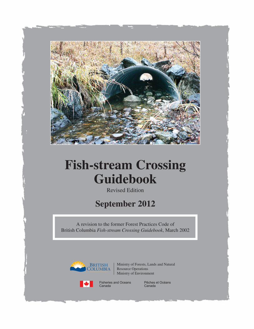
Fish-stream Crossing Guidebook Revised Edition September 2012 A revision to the former Forest Practices Code of British Columbia Fish-stream Crossing Guidebook, March 2002 Ministry of Forests, Lands and Natural Resource Operations Ministry of Environment
Transcript
Fish-stream CrossingGuidebook
Revised Edition
September 2012
A revision to the former Forest Practices Code of British Columbia Fish-stream Crossing Guidebook, March 2002
Ministry of Forests, Lands and Natural Resource OperationsMinistry of Environment
Fish-stream Crossing Guidebook
Revised Edition
September 2012
A revision to the former Forest Practices Code of British Columbia Fish-stream Crossing Guidebook, March 2002
Library and Archives Canada Cataloguing in Publication
Includes bibliographical references.Electronic monograph in PDF format.Issued also in printed form.Co-published by: BC Ministry of Forests, Lands and Natural Resource Operations and Fisheries and Oceans Canada.
ISBN 978-0-7726-6368-9
1. Fishes--Habitat--Conservation--British Columbia. 2. Bridges--British Columbia--Design and construction. 3. Forest roads--Environmental aspects--British Columbia. 4. Stream conservation--British Columbia. I. Canada. Dept. of Fisheries and Oceans II. British Columbia. Ministry of Environment III. British Columbia. Ministry of Forests, Lands and Natural Resource Operations
Citation:B.C. Ministry of Forests, Lands and Natural Resource Operations, B.C. Ministry of Environment, and Fisheries and Oceans Canada. 2012. Fish-stream crossing guidebook. Rev. ed. For. Prac. Invest. Br. Victoria, B.C.
For copies of this or any guidebook, contact:Crown Publications, Queen’s PrinterPO Box 9452 Stn. Prov. Govt.Victoria BC V8W 9V7Telephone: 1-800-663-6105 (outside Victoria) (250) 387-6409 (within Victoria) Fax: (250) 387-1120Internet: http://www.crownpub.bc.ca/
Guidebooks are also available on the British Columbia Ministry of Forests, Lands and Natural Resource Operations website at: http://www.for.gov.bc.ca/tasb/legsregs/fpc/FPCGUIDE/Guidetoc.htm
On the cover: Hotfish Creek (100 Mile House, B.C.) fish-stream crossing functioning as designed. Designed and constructed (2002) in co-operation with licensee as a pilot project to demon-strate fish-stream crossing guidance for an embedded culvert as provided in the 2002 Fish-stream Crossing Guidebook. Design Engineers: Brian Chow, PEng, Senior Roads and Structures Engineer, B.C. Ministry of Forests and Range; and George Robison, PE, PhD. Photo taken October 2010 by Roger Packham, RPBio. For more information on Engineering & Real Estate Operations – Bridges & Major Culverts, and related information, please visithttp://www.for.gov.bc.ca/hth/engineering/Bridges_And_Major_Culverts.htm
The purpose of this revised guidebook is to help forest and other resource managers and practitioners plan, prescribe, and implement sound fish-stream crossing practices to maintain fish passage and protect fish and fish habitat as required by the Forest and Range Practices Act and the federal Fisheries Act. It provides practitioners with current legislative and technical reference mate-rial regarding fish passage, including British Columbia’s strategic approach to addressing fish passage at culverts. It retains the same title as the previous (2002) Forest Practices Code–era guidebook to avoid an update of the many websites that reference this document. Furthermore, although forest legisla-tion has since evolved to the more results-based Forest and Range Practices Act, the requirement to maintain fish passage has remained the same. Thus, this new version of the guidebook ensures that professionals have the latest information regarding fish passage to help them achieve expected results under the new legislative regime.
As noted above, the guidebook also identifies a strategic approach for pre-Code structures that encompasses a holistic procedure to assess culverts for passage of fish, including all structures regardless of age or origin of the problem. The guidebook sets the standard for a process of prioritization that all land managers can use in determining remediation plans.
Fish-stream Crossing Guidebook
iv
ACKNOWLEDGEMENTS
The Fish-stream Crossing Guidebook, 2012 is a revision of the Forest Practices Code Fish-stream Crossing Guidebook, March 2002. It is difficult to attribute specific authorship to this revised guidance document, as so many technical experts and professionals have been involved in various iterations over the years. The Fish Passage Technical Working Group would like to acknowledge as many of those involved as possible, and apologize if we have inadvertently missed any.
For their contributions towards the completion of this revised guidebook, we thank: Brian Chow, Dave Maloney, Ian Miller, and Shirley Turcotte from the B.C. Ministry of Forests, Lands and Natural Resource Operations; Peter Tschaplinski, Richard Thompson, and Craig Mount from the B.C. Ministry of Environment; Jeff Guerin and Holly Pulvermacher from Fisheries and Oceans Canada; and consultants Gordon Mackinnon (Wildrock Ventures Ltd.) and Angeline Tillmanns (Adelaide Consulting).
The Working Group also recognizes the significant efforts that went into pro-ducing the 2002 guidebook. The original committee members included Gordon Mackinnon (Wildrock Ventures Ltd.), who kept the group function-ing, brought technical expertise to the project, and facilitated the writing. Others, who contributed time and effort to write and review the many drafts, included: Doug Morrison, Greg McKinnon, and Richard Thompson (B.C. Ministry of Environment); Ron Davis and Brian Chow (B.C. Ministry of Forests); Nick Winfield (federal Department of Fisheries and Oceans); Peter Affleck (Council of Forest Industries); Les Kiss (Coast Forest and Lumber Association); and Peter Davis (Oil and Gas Commission). In addition to those directly involved, we also thank the many reviewers of draft materials, including Peter Tschaplinski, Roger Packham, Bill Arthur, and Leslie McKinley, all from the B.C. Ministry of Environment.
the restoration of fish passage at culvert-stream crossings . . . . . . . . . . . . . . . . . . . . 50
Fish-stream Crossing Guidebook
1
1 IntroductionThis guidebook is designed to help forest and other resource managers and practitioners plan, prescribe, and implement sound fish-stream crossing prac-tices to maintain fish passage and protect fish and fish habitat as required by the Forest and Range Practices Act and the federal Fisheries Act.
The guidebook’s three parts cover:
1. Legislation and Review Process (Sections 2 and 3);2. Fish-stream Crossings: Design, Installation, and Maintenance
Considerations (Sections 4, 5, 6, and 7); and3. Assessment and Restoration of Fish Passage at Culvert-stream Crossings
(Section 8).
By following the procedures detailed in this guidebook, users can work to achieve a balance among the needs of the forest industry and other resource industries, and those who are empowered to protect fish resources. The information provided here should help users exercise their professional and technical judgement in developing site-specific management strategies and prescriptions to meet resource management objectives. The recommenda-tions set out a range of options or outcomes that may be considered acceptable under varying circumstances.
Specifically, the guidebook provides users with statutory reference, technical, and process guidance for selecting, designing, assessing, and monitoring fish-stream crossings on forest roads (though technical guidance is relevant to all crossings) that should: • avoidharmingfishandfishhabitat,• providefishpassageatstream1 crossing sites, and • aidinsettingprioritiesforrestoration.
The Forest and Range Practices Act and the federal Fisheries Act require maintenance of fish passage and the protection of fish and fish habitat. Examples are given to illustrate the methods and recommended procedures for road crossings of streams in an effective and efficient manner.
Not provided here is guidance for engineering practices related to the design and stability of drainage structures. Rather, the emphasis is on fish habitat and fish passage. For further discussion on structural or hydrological require-ments, refer to the Forest Practices Code Forest Road Engineering Guidebook (2002) and the Ministry of Forests, Lands and Natural Resource Operations’ Bridge Design and Construction Manual (1999).
These guidelines do not preclude the use of other processes (e.g., http://www.stream.fs.fed.us/fishxing/) and structures, provided these meet the require-
ments of provincial and federal legislation. For more information, see the section on “References and Recommended Additional Reading” at the end of the guidebook.
1.1 Guidebook Objectives This guidebook aims to provide forest and other resource management prac-titioners with guidance in:
• protectingfishandfishhabitatandaccommodatingthesafepassageoffish during the location, design, installation, maintenance, and deactiva-tion of stream crossings;
• administeringanefficientregulatoryprocessthataddressesallfederaland provincial legal requirements related to the construction, mainte-nance, and deactivation of stream crossing structures on forest roads;
• pursuingoptionsthatrecognizethevalueandsensitivityoffishandfishhabitat in balance with other environmental, social, resource, and eco-nomic values; and
• administeringtheassessmentandrestorationoffishpassageatculvertfish-stream crossings (see Glossary for definition of a fish stream).
1.2 Changes in this Updated EditionRevisions to the 2002 guidebook have been made to update Part 1 to match current provincial and federal legislation and regulatory approval processes. Part 2 has largely been left unchanged, as the technical basis for ensuring fish passage at stream crossings remains sound. Part 3, a new addition to the guidebook, provides an introduction to the protocol for the assessment of fish passage at culvert-stream crossings.
Specifically, technical updates since the 2002 guidebook include the following.
• TheSpecies at Risk Act prohibits the harming, harassing, capturing, tak-ing, or killing of a species at risk or the destruction of its “residence” or “critical habitat” as defined by the act (see Section 2.2.2 and Section 3 in this guidebook).
• Theuseoflogbundlesinsnowcrossingsandicebridgesisnolongerrecommended in accordance with Fisheries and Oceans Canada Operational Statements.
1.3 Recognition of this Guidebook by Fisheries and Oceans CanadaFisheries and Oceans Canada (DFO) continues to recognize this guidebook as providing guidance for minimizing risk to fish and fish habitat during the planning, construction, maintenance, and deactivation of fish-stream cross-ings on forest roads in British Columbia. Since the 2002 edition, DFO has updated its project review processes and streamlining tools such as opera-tional statements (OSs). These statements are available for common, low-risk activities (including some stream crossing construction and maintenance activities), and outline the conditions and measures for avoiding harmful
Fish-stream Crossing Guidebook
3
alteration, disruption, and destruction of fish habitat. If you elect to apply an OS, are able to meet all of its conditions, and apply all of its measures, you may proceed under the streamlined notification process. For higher-risk or more complex projects, you should refer to the guidance provided here to assess how best to reduce risk and prevent impacts to fish and fish habitat. Further information about DFO’s project review process is available on its new Working Near Water in BC and Yukon website (see “Planning work or activities near water?”: http://www.pac.dfo-mpo.gc.ca/habitat/know-savoir-eng.htm). This information is also reflected in the regulatory and legislative updates in this guidebook.
2. Legislative AuthoritiesThe primary focus of this guidebook is fish-stream crossings overseen by pro-fessionals on forested Crown land under the authority of the provincial Forest and Range Practices Act and with the potential to require an authorization under the federal Fisheries Act. It is the responsibility of the proponent to determine whether other provincial or federal legislation is triggered by the activity.
A number of federal and provincial authorities have jurisdiction to regulate works in and about a stream. Provincially, the Forest and Range Practices Act regulates the construction, maintenance, and deactivation of stream crossings on forested Crown land. Depending on the nature of the activities, other pro-vincial acts (e.g., the Oil and Gas Activities Act, the Water Act, the Land Act, the Mines Act, and the Drinking Water Protection Act) may come into effect.
When planning works in and about a stream, several federal regulations need to be considered. The federal Fisheries Act provides for protection of fish, fish habitat, and unimpeded fish passage and is administered by Fisheries and Oceans Canada’s Habitat Management Program. Other federal acts that may come into effect include the Navigable Waters Protection Act, the Species at Risk Act, and the Canadian Environmental Assessment Act.
2.1 Provincial Legislation
2.1.1 Forest and Range Practices Act The Forest and Range Practices Act (FRPA) took effect on January 31, 2004. This act and its regulations govern the activities of forest and range licensees in British Columbia and set the requirements for forest activities, including stream crossings on fish streams.
The Forest Planning and Practices Regulation defines fish streams and requires that those engaged in a primary forest activity, or those maintaining a fish-stream crossing built after June 15, 1995, must ensure that the primary forest activity does not have a material adverse effect2 on fish passage in a fish stream. Similar provisions apply to holders of range and woodlot ten-ures, through the Range Planning and Practices Regulation and the Woodlot Licensee Planning and Practices Regulation, respectively.
The Forest Practices Code of British Columbia Act provided a legal frame-work for forest practices in British Columbia from June 15, 1995, until the implementation of FRPA in 2004. Proponents who received authorization to
2 For a discussion of the definition of “material adverse effect,” please see the B.C. Ministry of Forests Lands and Natural Resource Operations’ Conservation and Enforcement Program Staff Bulletin No. 40 available at: http://www.for.gov.bc.ca/mof/interpretiveBulletins/.
carry out instream works during this period were required to have done so in accordance with this act and its regulations. The Forest Practices Code con-tained requirements to provide for and maintain fish passage at forestry road crossings on fish streams.
2.1.2 Oil and Gas Activities Act The Oil and Gas Commission is the regulatory body that issues permits for provincially regulated oil and gas activities. New roads required to access oil and gas developments are generally approved under the Oil and Gas Activities Act. Requirements for the crossing of streams, wetlands, and lakes are speci-fied under the Environmental Protection and Management Regulation. Readers requiring more information on the permitting process should contact the Oil and Gas Commission (http://www.bcogc.ca/contact.aspx).
2.1.3 Water Act3
Section 9 of the Water Act regulates “changes in and or about a stream” and Part 7 of the Water Regulation sets out provisions to protect water quality, fish, and wildlife habitat. Depending upon the activity, either an “Approval” or a “Notification” may be required under this act.
An Approval is a written authorization for changes in and about a stream that are of a complex nature. Approvals under the Water Act are the responsibility of the regional office of the B.C. Ministry of Forests, Lands and Natural Resource Operations.
Notifications are typically used for works that do not involve any diversion of water, may be completed within a short period of time, and will have min-imal impact on the environment or third parties.
Under Section 44 (2) of the Water Regulation, a change may be made in and about a stream to which a standard or regulation under the Forest and Range Practices Act applies, without obtaining an approval or licence, if a permit or agreement is held under the Forest Act, Range Act, or Forest Practices Code of British Columbia Act. The Oil and Gas Commission also has authority for certain sections of the Water Act that pertain to any alterations to, and work in and about, a stream for a petroleum road or other petroleum or pipeline-related operation (for more information, readers should contact the Oil and Gas Commission [http://www.bcogc.ca/contact.aspx]).
Section 44(3) of the Water Act also exempts a person who holds a permit under Section 10 of the Mines Act from having to comply with the regula-tion, as long as that person complies with Part 9 of the Health, Safety and Reclamation Code for Mines in British Columbia, and with all conditions of the permit respecting changes in and about the stream.
3 The Water Act is undergoing modernization, and is expected to be replaced by the Water Sustainability Act.
For more information on notifications and authorizations necessary under the Water Act, please visit: http://www.env.gov.bc.ca/wsd/water_rights/licence_application/section9/.
2.1.4 Land Act Rights-of-way may also be issued under the Land Act for linear corridors and transportation routes for mining, energy, and oil and gas operations.
2.1.5 Mines Act, Mineral Tenure Act, and Mining Right of Way Act The B.C. Ministry of Forests, Lands and Natural Resource Operations regulates exploration activities on mineral tenures under the Mineral Exploration Code, enabled under Section 34 of the Mines Act. The Mineral Exploration Code, which forms Part 9 of the larger Health, Safety and Reclamation Code for Mines in British Columbia, supersedes the Water Act and the Forest and Range Practices Act. Off-tenure roads must meet the requirements of the Forest and Range Practices Act for construction, maintenance, and deactivation.
Under the Mineral Tenure Act, a free miner has the right to enter all mineral lands to locate a claim or explore for, develop, and produce minerals. Additionally, the Mining Right of Way Act gives a mineral claim holder or free miner the right-of-way to construct or maintain mining facilities and to trans-port mineral or equipment and supplies into and from the mining property.
2.1.6 Drinking Water Protection Act and the Drinking Water Protection Regulation
The Drinking Water Protection Act and the Drinking Water Protection Regulation outline the conditions and requirements for water suppliers for all water systems other than single-family dwellings and systems excluded through regulation. Although the Drinking Water Protection Act identifies requirements for drinking water operators to provide safe drinking water to their customers, the act also identifies restrictions regarding the introduction of anything harm-ful to human health in water diverted to a domestic water system. These restric-tions apply both within and outside of community watersheds.
2.2 Federal Legislation
2.2.1 Fisheries Act Fisheries and Oceans Canada (DFO) is responsible for the conservation and protection of fish and fish habitat across Canada. The habitat protection provi-sions of the Fisheries Act, administered by the Habitat Management Program, form the regulatory context under which DFO reviews stream-crossing propos-als, among other activities. The Policy for the Management of Fish Habitat, with its Guiding Principles of “No Net Loss of the Productive Capacity of Fish Habitat,” guides the administration of the Fisheries Act’s habitat protection pro-visions. In addition, the Practitioners Guide to the Risk Management
Framework for DFO Habitat Management Staff provides a risk-based manage-ment approach to impact assessment and decision making. For additional information related to the Fisheries Act and relevant guiding policies and prin-ciples, visit: http://www.pac.dfo-mpo.gc.ca/habitat/guide-eng.htm.
The following sections of the Fisheries Act are most relevant to stream cross-ings (paraphrased below).
• Section35(1)prohibitsworksorundertakingsthatresultinthe“harmfulalteration, disruption or destruction” (HADD) of fish habitat.
• Section35(2)allowsfortheAuthorizationofaHADDoffishhabitatbythe Minister of DFO.
• Section36(3)prohibitsthedepositofadeleterioussubstanceintowatersfrequentedbyfish,orinanyplacewhereitmayentersuchwaters.Note:Exceptforphysicalimpactsfromsediment(e.g.,smothering,infilling),this section of the Fisheries ActisadministeredbyEnvironmentCanada.
• Sections20and22requirethemaintenanceoffishpassageandsufficientflows for fish.
2.2.2 Species at Risk ActThe Species at Risk Act (SARA)isprimarilyadministeredbyEnvironmentCanadaandtheCanadianWildlifeService,withassistancefromDFO(foraquaticspecies)andotherfederalagenciessuchasParksCanada.Thepur-pose of the act is to prevent wildlife species from being extirpated or becomingextinct;toprovidefortherecoveryofwildlifespeciesthatareextirpated,endangered,orthreatenedasaresultofhumanactivity;andtomanage species of special concern to prevent them from becoming endan-geredorthreatened.TheMinisterofEnvironmentCanadaisthecompetentminister responsible for overall co-ordination and administration of the SARA. The Minister of DFO is the competent minister for listed aquatic spe-ciesincludingfishandmarineplants,andParksCanadaisresponsibleforall species in or on federal lands that are national parks, national historic sites, or other protected heritage areas.
Of particular relevance to stream crossing projects, provisions in the act pro-hibit the killing, harming, harassing, capturing, or taking of listed species, or thedamagingordestroyingoftheresidenceofanindividualofalistedspe-cies. During the course of planning and assessing a stream crossing project, theproponentshoulddeterminewhetheranySARA-listed species, its resi-dence,or“criticalhabitat”maybeimpactedbytheproject.
Sections73and74oftheactprovideamechanismforissuingpermitsandagreementsforactivitiesthatmayresultineffectstoaspeciesatrisk,itsresi-dence,orcriticalhabitat.ProhibitionsundertheactdonotapplytoactivitiesauthorizedunderSections73(bypermitsoragreements)or74(byagree-ments,permits,licences,orders,orsimilardocumentsissuedbythecompetentminister under another act of Parliament [e.g., Fisheries Actauthorizations]),as long as a series of strict preconditions can be met before issuing the autho-rization.Forfurtherinformationonpermitting,checktheSARA website at: http://www.dfo-mpo.gc.ca/species-especes/permits-permis/permits-eng.htm.
Section79appliestoeverypersonwhoisrequiredbyorunderafederalactof Parliament to ensure that an assessment of the environmental effects of a project is conducted under the Canadian Environmental Assessment Act. Underthissection,everypersonwhoisrequiredtoconductanassessmentofthe environmental effects of a project must:
1. notifythecompetentministerinwritingifaprojectislikelytoaffectalisted wildlife species or its critical habitat; and
ChecktheSARAwebsite(http://www.sararegistry.gc.ca)forthemostup-to-date information regarding species at risk in a project area and to determine how the act applies.
2.2.3 Canadian Environmental Assessment ActThe role of the Canadian Environmental Assessment Act is to ensure the environmental review of individual projects and that a cumulative effects assessment and public consultation occur, where appropriate. Four regula-tions under the act (e.g., the Exclusion List Regulations, the Law List Regulations,theComprehensiveStudyListRegulations,andtheInclusionListRegulations)specifywhichprojectsare(orarenot)subjecttoenviron-mental assessment. The following regulations are most relevant to water-course crossings.
• TheExclusionListRegulationsidentifyphysicalworksthatdonotrequire an environmental assessment under the act, such as proposed maintenance and repair of works.
• TheLawListRegulationsspecifythosestatutoryandregulatoryprojectapprovals that trigger an environmental assessment under the act.
For additional information relating to the content or application of the acts and regulations noted, or processes related to environmental assessments, please refer to the Canadian Environmental Assessment Act website (http://www.ceaa.gc.ca), which contains guidance documents for practitioners and agencies involved in an environmental assessment.
2.2.4 Navigable Waters Protection Act The Navigable Waters Protection Act regulates works in, on, under, and over navigable waters, and is administered by Transport Canada’s Navigable Waters Protection Program. The act prohibits the construction of any work in navigable water without an Approval from the Minister of Transport unless the work or waterway qualifies as a “Minor Work or Water.”
To obtain an Approval for works on or below the high-water mark, such as placing riprap, or constructing or replacing a bridge or culvert, you must apply to Transport Canada, unless the project qualifies as a Minor Work or Water. Upon receiving an application, Transport Canada will be able to deter-mine the navigability of the waterway to determine whether an Approval is required. An Approval may trigger an environmental assessment under the Canadian Environmental Assessment Act.
The Minor Works and Waters Order identifies certain classes of works and navigable waters that may be exempted from the application process under the act. Proponents are expected to assess their project using the criteria for the type of work or waterway as outlined in Minor Works and Waters Order. To comply with the Order requirements, proponents are fully responsible for ensuring that all criteria are met. If the project does not meet all of the criteria specified in the Minor Works and Waters Order, then an application must be submitted.
A copy of the Minor Works and Waters Order and Application is available online at: http://www.tc.gc.ca/eng/marinesafety/oep-nwpp-minorworks-menu-1743.htm. For further advice, please contact the Navigable Waters Protection Program office in Vancouver (http://www.tc.gc.ca/eng/marinesafety/oep-nwpp-offices-102.htm#pacific).
3. Review Processes When constructing a new fish-stream crossing, several decisions need to be made before the review requirements can be determined. The first step is to evaluate the fish and fish habitat. The second is to verify the most appropriate crossing structure based on the stream gradient, fish, and fish habitat present. The third step is to determine the review requirements.
If replacing an existing fish-stream crossing structure, the three-step process outlined above may still be necessary. Replacement structures are defined as those that occupy the same riparian management area and crossing location in plan view as the original structure. All replacement structures should be treated as new installations except where:
• anopen-bottomstructure(OBS)isbeingreplacedwithanotherOBSwithout disturbance to the bed of the waterway; or
• anun-embeddedclosed-bottomstructure(CBS)isbeingreplacedwithanOBS in marginal habitat.
If the above conditions are met, replacement structures can proceed without site-specific approval provided that:
• theprojectwillnotresultinanyimpactstoaSARA-listed species, its resi-dence, or critical habitat (as defined by the Species at Risk Act);
• theworksoccurwithintheappropriatefisheriestimingwindow(seeAppendix 1); and
• fishpassagewillbemaintainedorenhanced.
Although site-specific approval by DFO is not required in these circumstanc-es, please submit a notification to DFO using the Project Notification and Review Application Form, which includes the location and timing of the con-struction (see Section 3.4).
3.1 Step One: Determine Habitat Type The proponent should evaluate the fish and fish habitat at the crossing site to determine whether the habitat:
• supportsaspeciesatrisk,itsresidence,oranycriticalhabitat(asdefinedby the Species at Risk Act); and
All fish habitat contributes to the success and productivity of fish popula-tions, albeit sometimes indirectly through food production and other factors. Any reduction in the quantity and quality of fish habitat may reduce fish pro-ductivity to some degree. Some habitat types make a greater contribution to fish productivity than others. For example, a critical habitat is one in which an incremental reduction in its supply may result in the largest corresponding reduction in fish productivity.
Fish-stream Crossing Guidebook
11
A qualified professional or technologist with adequate training and knowledge of species at risk, fish, and fish habitat should conduct this habitat evaluation. When determining the appropriate crossing structure and in justifying the classification of marginal habitat, consideration should be given to both physical and biological characteristics at the crossing, as well as upstream and downstream of the crossing. Basic physical characteristics to consider include flow, current, cover, channel depth, channel stability, substrate, and general habitat type. Biological characteristics to consider include aquatic vegetation, riparian vegetation, and fish species (type and life stage).
3.2 Step Two: Determine Appropriate Crossing StructureThe choice of crossing structure will depend on the specific conditions at
Table 1. Definition and indicators of fish habitat types
Habitat at crossing site
Critical Important Marginal
Definition Habitat that is critical in sustaining a subsistence, commercial, or recreational fishery, or any species at risk (i.e., terrestrial or aquatic red- and blue-listed species, those designated by the Committee on the Status of Endangered Wildlife in Canada, or those SARA-listed species), or because of its relative rareness, productivity, and (or) sensitivity.a
Habitat that is used by fish for feeding, growth, and migration but is not deemed to be critical. This category of habitat usually contains a large amount of similar habitat that is readily available to the stock.
Habitat that has low productive capacity and contributes marginally to fish production.
Indicatorsb The presence of high-value spawning or rearing habitat (e.g., locations with an abundance of suitably sized spawning gravels, deep pools, undercut banks, or stable debris, which are critical to the population present), or the presence of any SARA-listed species, its residence, or critical habitat.c
Important migration corridors. The presence of suitable spawning habitat. Habitat with moderate rearing potential for the fish species present.
The absence of suitable spawning habitat, and habitat with low rearing potential (e.g., locations with a distinct absence of deep pools, undercut banks, or stable debris, and with little or no suitably sized spawning gravels for the fish species present).
a See http://www.env.gov.bc.ca/wld/serisk.htm or http://www.cosewic.gc.ca/.b The indicators provided here are highly generalized and may require regional interpretation. For further information on
conducting a habitat assessment, see: Fisheries and Oceans Canada’s Working Near Water in BC and Yukon website (http://www.pac.dfo-mpo.gc.ca/habitat/index-eng.htm) and the B.C. Ministry of Environment’s Fish and Fish Habitats website (http://www.env.gov.bc.ca/wld/fishhabitats/index.html).
c The Species at Risk Act prohibits the harming, harassing, capturing, taking, or killing of a species at risk or the destruction of its residence, or critical habitat as defined by act (see glossary). For more information about SARA-listed species and their habitat, see: http://www.sararegistry.gc.ca.
each site, making formulaic recommendations difficult; however, Figure 1 provides a matrix based on stream gradient and habitat type, which will assist the proponent in selecting the most appropriate crossing structure. Other factors, such as fans and debris potential, may also require consideration when choosing an appropriate structure and assessing its long-term structural integrity. Where economics or other issues warrant, the proponent may default to an OBS.
Figure 1. Decision-making matrix for selecting type of new installation acceptable for fish-stream crossings.
Notes: a. Open-bottom structures include bridges and open-bottom culverts
(log culverts, arch culverts).b. Closed-bottom structures include embedded corrugated metal pipes.c. Seek a review under the Fisheries Act.d. Necessary conditions: (1) stream channel width is 2.5 m or less; (2) CBS
is embedded to replicate streambed inside pipe; and (3) construction adheres to appropriate fisheries timing windows (see Appendix 1).
Note: Arch-type structures installed on fish streams that require excavation and reconstruction of the streambed and streambanks are to be treated as closed-bottom structures for review process purposes.
Critical Important Marginal
>6%
3–6%
<3%
Str
eam
gra
die
nt
OBS preferred.
CBSb installation may be subject to Fisheries Act authorization.c
CBS can proceed provided that necessary conditions are met.d
Habitat Type
OBSa recommended.
Fish-stream Crossing Guidebook
13
In critical and important fish habitats, and in marginal fish habitat where stream gradient exceeds 6% (black and dark grey boxes, Figure 1), the instal-lation of an embedded CBS or arch-type culvert, which requires excavation of the streambed and banks or encroachment on the stream channel width (Appendix 2), is not recommended because of the risk to fish and fish habitat and the difficulty in providing and maintaining fish passage under such con-ditions. Such proposals should be considered only where no other practicable alternative exists and are subject to review by DFO.
In marginal habitat with a slope of 6% or less (white boxes, Figure 1), the installation of an embedded CBS can proceed when: (1) the stream channel is 2.5 m wide or less; (2) the CBS is embedded and the streambed character-istics are replicated inside the pipe; and (3) work is conducted within the instream work window for fisheries resource protection (see Appendix 1 for further details).
Although an increase in stream gradients higher than 3% has no influence on the structure recommended in Figure 1, the figure emphasizes the increased risk associated with the long-term maintenance of substrate necessary for fish pas-sage in embedded culverts as slope increases. Requirements for substrate size and placement differ for culverts installed at gradients greater than 3% (see Section 4.2). These structures are discussed in detail in Part 2 of this guidebook.
3.3 Step Three: Determine Necessary Regulatory ApprovalsThe review process for forest roads that cross fish streams potentially involves two levels of government — provincial and federal. To expedite the review, fisheries agency referrals should be accompanied by a Project Notification and Review Application Form (see Section 3.4) that contains all necessary information.
3.3.1 Provincial reviewUnder the Forest and Range Practices Act, forestry-related activities must not cause a material adverse effect on fish passage in a fish stream. This act is founded on the principle of professional reliance. As such, qualified profes-sionals must ensure that crossings are built in a manner that upholds legal requirements and provincial objectives for stream crossings. If an authorization was obtained under different legislation, then the proponent must ensure that all notification and authorization requirements of that legislation are upheld (see Section 2.1 for a brief synopsis of the potential applicable provincial legislation).
Provincial objectives to be met at a crossing site include providing for fish passage, and protecting fish and fish habitat by:
• preventingimpactsonfisheggsandalevins that are present in the gravel, or on adult and juvenile fish that are spawning, migrating, or rearing; and
• reducingtheriskofreleasingsedimentorotherdeleterioussubstancesduring work at stream crossings.
Fish-stream Crossing Guidebook
14
3.3.2 Federalfisheriesreview4
Once the habitat type and the most appropriate type of crossing structure has been determined (using Table 1 and Figure 1), Figure 2 can further assist the proponent in determining whether DFO may require a site-specific project review and Letter of Advice or Section 35(2) Fisheries Act Authorization.
Should a proponent wish to proceed with the installation of an embedded CBS in critical habitat, an aquatic effects assessment and Project Notification and Review Application Form should be submitted for DFO review (see Section 3.4). Installation of stream crossings that will result in a harmful alteration, disruption, or destruction of fish habitat can proceed only under a Section 35(2) Fisheries Act Authorization.
Notes: a. Refer to DFO’s Working Near Water in BC and Yukon website to access the Project
Notification and Review Application Form and to access a list of DFO referral centres.
• OBS can proceed without site-specific approval from DFO subject to this guidebook (Section 4.1) and to installation occurring within the timing window (see Appendix 1).
• Submission of a PRAF notification to appropriate DFO referral centre is requested.a
• Embedded CBS can proceed without site-specific approval from DFO subject to this guidebook (Sections 4.2 and 5.0) and to installation occurring within the timing window (see Appendix 1).
• Submission of a PRAF notification to appropriate DFO referral centre is requested.a
• Installation may be subject to agency monitoring.
Disturbance toin-stream fish habitat?
orEncroachment upon
stream channel?or
Impact to a SARA-listed fish species, its residence,
or “critical habitat” (as defined by SARA)?
Refer toDFO Working Near Water
website. Submit PRAF
to DFO referral centre.a
CBS notrecommended.
Refer to DFO Working Near Water website. Submit PRAF to DFO
referral centre.a
CBS not recommended.Fisheries Act
Authorization may be required. Submit
PRAF to DFO referral centre.a
Figure 2. Federal Fisheries and Oceans Canada review process for new installations.
4 This section focusses primarily on the Fisheries Act. The proponent must determine the notification or approval require-ments of other relevant federal legislation.
Fish-stream Crossing Guidebook
15
3.3.2.1 Open-bottom structures
An OBS does not require site-specific approval if the crossing is constructed within the appropriate fisheries timing window (see Appendix 1), and if it spans the stream without:
1. disturbing instream fish habitat; 2. encroaching on the stream channel width; 3. causing excessive loss of riparian vegetation; or4. affecting a SARA-listed species, its residence, or critical habitat (as
defined under the Species at Risk Act).
Where the above conditions can be met, an OBS can proceed without further DFO approval, however DFO does request adequate notification. Use DFO’s Project Notification and Review Application Form (check off “notification only”) and submit your notification to the appropriate DFO referral centre at least 10 days before beginning your works (see Section 3.4).
If (1), (2), (3), or (4) above is anticipated, a Fisheries Act Authorization may be required based on the scale of negative effect and the sensitivity of fish and fish habitat at the site. The proponent should complete and submit a Project Notification and Review Application Form to the appropriate DFO referral centre (see DFO’s Working Near Water in BC and Yukon website at http://www.pac.dfo-mpo.gc.ca/habitat/index-eng.htm). If a SARA-listed spe-cies, its residence, or critical habitat (as defined under the Species at Risk Act) is present and will be (or has been) impacted, the proponent is required to contact the appropriate agency as indicated by the competent Minister.
Note: Arch-type structures installed on fish streams that require excavation and reconstruction of the streambed and streambanks are to be treated as closed-bottom structures for review process purposes.
3.3.2.2 Embedded closed-bottom structures
In critical and important fish habitats, and in marginal fish habitat where stream gradient exceeds 6% (black and grey boxes, Figure 1), the installation of an embedded CBS or arch-type culvert will require an individual project review; a Section 35(2) Fisheries Act Authorization may also be required.
Installation of an embedded CBS in marginal habitat is normally acceptable where stream gradients are 6% or less, stream channel width is 2.5 m or less, streambed depth is adequate to permit excavation, and the project avoids impacts to species at risk. Such installations may proceed without site-specif-ic approval by DFO in marginal habitat provided that:
• requirementstomitigateanydamagetofishhabitataremet(asoutlinedin Section 5 of this guidebook);
• theinstallationiscarriedoutwithintheappropriatefisheriestimingwin-dow (see Appendix 1); and
• designandinstallationmaintainfishpassageandarecarriedoutaccord-ing to Section 4.2 of this guidebook.
Although site-specific approval by DFO is not required in these circum-stances, please submit a notification to DFO using the Project Notification and Review Application Form, which includes the location and timing of the construction (see Section 3.4).
Practitioners should be adequately trained in the design and installation of an embedded CBS (as outlined in Section 4.2) and in the recommended tech-niques for mitigating impacts to fish and fish habitat during construction of an embedded culvert. The goal is to retain the natural stream substrate, flow, and fish passage characteristics within the culvert. Migrating fish should suf-fer no changes or stress and no delay in upstream migration. Substrate should also move through the culvert naturally.
3.3.3 FisheriesandOceansCanadareviewprocessFisheries and Oceans Canada’s Working Near Water in BC and Yukon web-site (http://www.pac.dfo-mpo.gc.ca/habitat/index-eng.htm) provides informa-tion regarding the agency’s project referral and review process. It offers guid-ance to assist proponents in planning and completing an Aquatic Effects Assessment and in preparing and submitting both project reviews and project notifications. The website also provides information regarding applicable guidelines and best management practices to assist in the development and design of stream crossings, fish sampling permit applications for fish-stream identification and fish salvage operations, and a list of applicable timing win-dows for instream works.
When a project review or Authorization is not necessary, DFO should be notified using the Project Notification and Review Application Form; check off “Notification to DFO” on the application form. Notifications should be provided at least 10 days before the installation of any fish-stream crossing structure. The notification should contain sufficient detail and a map at an appropriate scale to permit compliance and effectiveness monitoring. Plans and specifications for crossings constructed without site-specific review should be retained by the proponent and made available if requested by a fisheries agency.
When a referral to DFO is required (see Figure 2), a qualified professional or technologist with adequate training or knowledge of fish habitat should pre-pare a Project Notification and Review Application Form; check off “request for project review” or “request for a Fisheries Act Authorization” as appro-priate. In general, a DFO review is based on the scale of negative effect and sensitivity of fish and fish habitat at the site. Consideration is given to the proposed mitigation and any residual effects to determine whether a Section 35(2) Fisheries Act Authorization is necessary. Project review requests should be submitted well in advance to allow sufficient time for review.
Application for a Section 35(2) Fisheries Act Authorization should be consid-ered only after all relocation and redesign options have been investigated and rejected with appropriate justification. Pursuant to the Canadian Environmental Assessment Act, DFO must conduct an environmental assessment before issu-ing a Section 35(2) Authorization. The agency must also identify any adverse effects of the project and ensure that measures are taken to minimize or avoid the effects and monitor them. If residual impacts to fish and fish habitat remain after relocation, redesign, and mitigation is applied, proponents may be required to provide suitable compensation. Requests for Authorizations should be submitted to DFO well in advance of the proposed start date.
In carrying out its responsibilities under the habitat protection provisions of the Fisheries Act, DFO may undertake consultation with potentially affected Aboriginal groups. This agency must also ensure that the requirements of the Species At Risk Act are met. When conducting an environmental assessment pursuant to this act, DFO must notify the competent Minister in writing if a project is likely to affect a listed species or its critical habitat. In addition to a Fisheries Act Authorization, an application for a SARA permit is required when a project is located within critical habitat (as defined under the Species at Risk Act) or is affecting a residence or individual of a SARA-listed species (e.g., salvage of SARA-listed species of fish).
3.4 Project Notification and Review Application Form for Stream Crossing Projects
Fisheries and Oceans Canada’s Project Notification and Review Application Form, available on the Working Near Water in BC and Yukon website at http://www.pac.dfo-mpo.gc.ca/habitat/steps/praf/index-eng.htm, serves as both a review application and notification form. Section 1 of this form allows clients to identify whether they are simply notifying DFO or requesting a project review or Section 35(2) Fisheries Act Authorization. For information about filling out this form, follow the “Directions for Project Notification and Review Application Form” hyperlink (http://www.pac.dfo-mpo.gc.ca/habitat/steps/praf/guide-eng.htm).
Completed forms can be submitted in person, via facsimile, or online to the appropriate DFO referral centre. The website provides information to assist you in determining to which DFO referral centre your project notification or review should be submitted.
Note: The DFO website includes other guidelines applicable to fish-stream crossing activities (e.g., Operational Statements). Resource road developers have the option to apply the Operational Statement or the Fish-stream Crossing Guidebook when designing, constructing, maintaining, or decommissioning their fish-stream crossing projects; however, when submitting a notification to DFO, please identify which guidance document you intend to apply to your works.
PART 2: Fish-stream Crossings: Design, Installation, and Maintenance Considerations
4. Design and Installation of Fish-stream Crossings This section discusses the design considerations and installation practices rec-ommended for various types of stream crossing structures. Refer to the Forest Practices Code Forest Road Engineering Guidebook (2002) and the current Forest Service Bridge Design and Construction Manual (1999) for details on the location and design of forest roads and stream crossings.
• Fish-streamcrossingstructuresshouldretainthepre-installationstreamconditions to the extent possible. The objective is to ensure that the cross-ing does not restrict the cross-sectional area below the high-water mark, change the stream gradient, or reduce or restrict fish passage, and that the streambed characteristics are retained or replicated.
• Thechoiceanddesignoffish-streamcrossingstructuresaredeterminedby a number of factors, including sensitivity of fish habitats, engineering requirements, cost and availability of materials, and cost of inspection, maintenance, and deactivation. Not all options are appropriate at all sites. The types of structures recommended in this guidebook for use on forest roads include:
– embedded closed-bottom structures (e.g., embedded corrugated metal pipes); and
– other structures (e.g., ice bridges and snowfills).
• Thislistdoesnotprecludetheuseofotherstructures,oracombinationof structures, provided that they meet the requirements of provincial and federal legislation. However, baffled culverts are not recommended for new installations. The hydraulic design requires specialized hydraulic modelling skills that go beyond the scope of this guidebook. In addition, locating roads and crossing structures in alluvial fans, where streams are in active floodplains, or where streams are meandering or braided, may require special design considerations not included in this guidebook. Where such installations are considered, a professional engineer and pro-fessional biologist should be consulted.
4.1 Open-bottom Structures
4.1.1 Designofopen-bottomstructuresFor forest roads in British Columbia, the Fish-stream Crossing Guidebook
Fish-stream Crossing Guidebook
19
considers open-bottom structures (OBSs) for fish-stream crossings to include bridges and open-bottom culverts such as log and arch culverts.
4.1.1.1 Bridges
When designed and constructed with abutments and scour protection that do not constrict the stream channel, bridges have the least impact on fish passage and fish habitat.
• Bridgescanbedesignedforpermanent,temporary,orseasonalinstallation.They range from log stringer bridges with gravel or timber decks, to steel girder bridges with timber or pre-cast concrete decks (see Figure 3). Bridges can be supported by various means, including log cribs, steel pipes, steel bin walls, cast-in-place concrete, and pre-cast lock block walls, timber, and piers. Where practicable, instream piers should be avoided. Piers can collect debris during flood events, resulting in scouring of bridge foundations. Instream piers can also result in hydrologic changes such as bedload scour or deposition, which may adversely affect fish habitat.
It can be expected that fisheries agencies may only consider bridges with instream impacts (such as support piers) after all other options (clear span) are considered.
Figure 3. Common types of bridges.
Timber deck Concrete deck
Steel girders
Riprap scour protection
Log crib abutment Concrete precast
footing and pipe abutmentStream channel
width
Specified debris/navigation clearance
Design high water level
Steel girder bridge
Fish-stream Crossing Guidebook
20
• Decisionstouseabridgeratherthanaculvertcanbedrivenbyeconom-ics, engineering requirements, site parameters, environmental or hydrau-lic concerns, or bedload and debris transport factors. References related to each of these activities are contained in the “References and Recommended Additional Reading” section.
Figure 3. Common types of bridges (continued).
Timber deckGravel deck Log stringers
Log crib abutment
Stream channel width
Specified debris/ navigation clearance
Design high water level
Riprap scour protection
Precast concrete slab bridge
Lock block abutment
Stream channel width
Specified debris/ navigation clearance
Design high water level
Log stringer bridge
Concrete slab bridge
Fish-stream Crossing Guidebook
21
4.1.1.2 Open-bottom culverts
Open-bottom culverts are similar to bridge structures, generally spanning the entire streambed and minimizing impacts to the natural stream channel (see Figure 4). They are differentiated from bridges in that the fill placed over these structures is an integral structural element.
• ThemostcommontypeofOBSisthelogculvert.Itiswidelyusedinareas where the availability of suitable logs makes it an economical alter-native to steel or concrete. Log culverts are readily adapted to meet flood requirements and generally do not pose a risk to fish passage when sill logs are placed to maintain the stream channel width. The OBS should be designed to span the stream channel width to avoid impacts on fish habi-tat and fish passage.
Depending on the stream profile, large sill logs or log cribbing may be required with log culverts to achieve adequate flow capacity. Alternatively, small sill logs can be used, but the span should be increased to get sill logs well above and outside the scour zone of the stream.
• Othertypesofopen-bottomculvertsincludearchesconstructedofsteel,plas-tic, and other materials. Arches come in various shapes, ranging from low to high profiles, and are typically installed on concrete or steel foundations.
• Itisimportanttodifferentiatebetweenarch-typeOBSsrequiringexca-vation and reconstruction of the streambed from larger arches that are constructed without disturbance to the streambed. The small bottomless arches should be designed and installed with the same considerations afforded to CBSs (see Section 4.2) and submitted for review by the appropriate fisheries agency where proposed in moderate or critical hab-itat. Careful engineering is required to ensure that the footings of these small arches are secure and not subject to undercutting.
4.1.2 Installationofopen-bottomstructuresThe nine steps below outline the general installation procedure for an OBS as it applies to fish streams. Refer to the Forest Road Engineering Guidebook (2002) and the Forest Service Bridge Design and Construction Manual (1999) for more details on construction practices.
1. Footings – Ensure that excavation and backfilling for footings does not encroach on the stream channel width.
2. Vibrations during construction – Practices such as pile driving and blasting, which can result in vibrations potentially harmful to fish or fish eggs, should meet the DFO Guidelines for the Use of Explosives In or Near Canadian Fisheries Waters (Wright and Hopky 1998) and be carried
Fish-stream Crossing Guidebook
22
Figure 4. Types of open-bottom culverts.
Stream channel width
Log culvert
Stream channel width
Low-profile arch
Fish-stream Crossing Guidebook
23
out during the instream timing windows. Isolation of the work site and fish salvage may be required to prevent the unauthorized killing of fish.
3. Sediment control at work site – Where feasible, operate all equipment from above the top of the streambank, isolate the work area from water sources, contain sediments within the work site, and pump out sediment-laden water to a settling site during construction and installation. Where the engineering design requires the placement of fill over the structure, such as in open-bottom arch culverts, fill material should be clean, suitably sized, and contained to prevent it from washing or eroding into the stream.
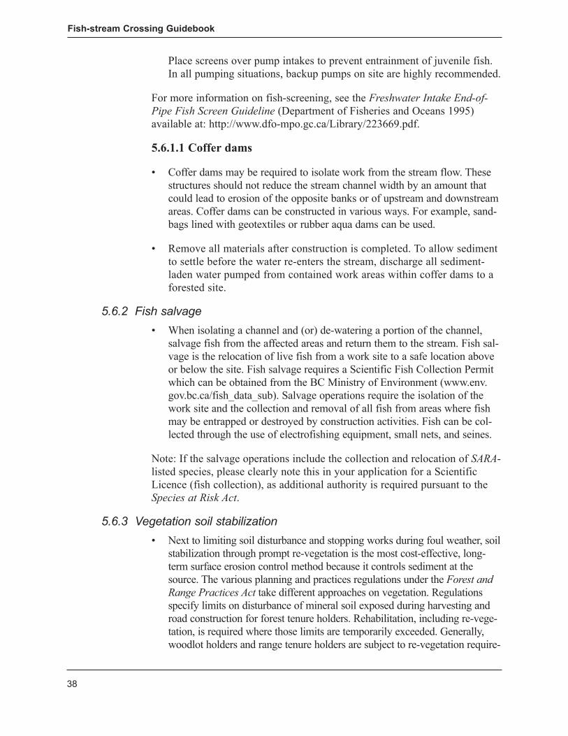
4. Drainage – Do not allow road ditches to drain directly into the stream (see Figure 11). Divert ditch water onto stable forested vegetation that can filter fine sediments before reaching the stream, or if this option is not possible, divert water to a constructed sump. Ensure that adequate cross drainage is in place before the bridge approach and that the bridge approach and deck are higher than the road grade to minimize water vol-ume directed into approach ditches at bridge sites. Consider crowning the surface, using rolling grades, or employing other practices to divert run-off from the road surface. Where cross-ditches are used, ensure that they are properly armoured at the outlet and along the base.
5. Constricting the stream – Do not allow activities, including the place-ment of riprap, to cause any constriction of the stream channel width (see Figure 4).
6. Deleterious materials – Use precautionary measures to prevent deleteri-ous substances, such as new concrete, grout, paint, ditch sediment, fuel, and preservatives, from entering streams. Treated wood and wood preser-vatives should be selected and used in accordance with the DFO publica-tion entitled Guidelines to Protect Fish and Fish Habitat from Treated Wood Used in Aquatic Environments in the Pacific Region (Hutton and Samis 2000).
7. Seepage barriers – Consider using geotextiles to prevent loss of fines and gravel through seepage along the arch wall. The fabric, or other cut-off measures such as sandbagging or use of prefabricated seepage barriers along the arch wall near the inlet, is intended to prevent most of the seep-age and mitigate potential support-fill erosion that can occur along the arch.
8. Geotextiles – For gravel-decked bridges or log culverts, use a geotextile filter fabric to fully cover the stringers or some other measure to prevent road material from entering the stream.
9. Turnouts – Construct turnouts a sufficient distance from the bridge to prevent road material from entering the stream and to minimize impacts on riparian vegetation.
Fish-stream Crossing Guidebook
24
4.2 Embedded Closed-bottom Structures
4.2.1 Designofembeddedclosed-bottomstructuresFor forest roads in British Columbia, a CBS for fish-stream crossings is a corrugated pipe (metal or plastic), which, embedded to retain stream sub-strate, provides fish habitat and fish passage (Figure 5). See Section 3 for information regarding the review process for an embedded CBS.
Supplemental larger material to help retain substrate
Culvert/streambed cross-section
Culvert/streambed profile
D
Fish-stream Crossing Guidebook
25
• Experienceinotherjurisdictions,particularlyOregon(Robison2001),has shown that an embedded CBS can be successfully installed when careful consideration is paid to site location conditions and structure design parameters (see Appendix 3). The embedment methodology (also known as stream simulation) consists of selecting a culvert (pipe) of adequate opening to encompass the stream channel width, and emulating the streambed within the culvert by lining the bottom with representative streambed substrate. The natural substrate materials are supplemented with additional larger material to help retain the substrate within the cul-vert and assist fish passage. By emulating the streambed and stream channel width, the culvert’s streamflow characteristics should reflect the natural streamflow characteristics.
• TheuseofanembeddedCBSinfishstreamsrequirescarefuldesignandlayout, paying particular attention to fish passage and fish habitat over the lifespan of the structure. The following four requirements should be addressed.
4.2.1.1 Streambed profile determination
• Adetailedprofileoftheexistingstreambedusingpreciseinstrumentsisrequired for an extended distance upstream and downstream of the pro-posed crossing (approximately 50 m each way). Benchmarks for elevation and construction control should be established. The objective is to accu-rately model the streambed profile. This should assist in determining the culvert slope, invert elevation, and streambed. An example is provided in Figure 6. Streams that have bedrock outcrops or little variation in bed ele-vation should generally require shorter profiles. Existing pipes with local sediment retention or scour as a result of the culvert may require longer profiles to get beyond the zones of induced disturbance.
• AnembeddedCBSshouldbedesignedandinstalledatthesameslopeasthe stream (see Figure 6), and should retain the same pre-construction stream gradient and substrate characteristics within the culvert. For migrating fish, this would impose no changes or stress, nor induce any delays at the crossing structure in upstream migration. Substrate transport should move through the culvert naturally, and there should be no sedi-ment build-up upstream or deprivation downstream.
• Wherepracticable,thenaturalmeanderpatternofastreamshouldberetained. An embedded CBS should not be placed in the bend of a stream, as this leads to bank erosion and debris problems. Where the above can-not be achieved, the crossing structure should be relocated or another chosen, such as an OBS.
Fish-stream Crossing Guidebook
26
4.2.1.2 Pipe size
• Asystematic,objectivemethodologytomeasurestreamchannelwidthispresented in Appendix 2. The stream channel width should determine the required culvert diameter/width. The width of the replicated or simulated streambed within the culvert should be equal to or greater than the stream channel width, to emulate the natural stream and to prevent deposition, scour-ing, or other damage at the outlet. Figure 7 illustrates stream channel width.
• ACBSmustbesizedtoaccommodatethe100-yearreturnperiodpeakflow after embedment. This flow determination must be carried out, and the pipe enlarged if it cannot otherwise pass the 100-year design flow.
• Factorsindeterminingtheappropriateculvertlengthincludedepthoffill,skew angle of the culvert to the road, gradient of the culvert, and required road width.
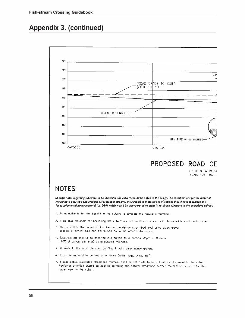
Figure 6. Stream elevation profile example for use in determining culvert slope and minimum invert level for an embedded culvert.
Note: The vertical placement of the culvert in relation to the overall stream longitudinal profile is extremely important. The culvert invert should be determined from the longitudinal profile of the streambed, ensuring that the culvert is located at a low point along the streambed profile. Special note should be made of any artificial or other non-permanent anomalies (such as large debris-holding or storing-bed material) that may not provide a suitable invert elevation.
Fish-stream Crossing Guidebook
27
• TheembeddedCBSshouldbeproperlydesignedtoavoidlettingsideslope and backfill material enter the culvert or flow channel. Riprap should be used to provide scour protection for materials potentially exposed to erosion.
Figure 7. Determining stream channel width.
Stream channel width
Edges of terrestrial rooted vegetation
Present water level
Stream channel width
Edges of terrestrial rooted vegetation
Present water level
Fish-stream Crossing Guidebook
28
4.2.1.3 Design embedment
• Forcylindricalculverts,theembedmentshouldmakeupatleast40%oftheculvert diameter or 0.6 m, whichever is greater. For pipe-arch or box culverts, embedment depth should be at least 20% of the vertical rise of the arch.
• Theverticalplacementoftheculvertinrelationtotheoverallstreamlongitudinal profile is extremely important. The culvert invert should be determined from the longitudinal profile of the streambed, ensuring that the culvert is located at a low point along the streambed profile (Figure 6).
• Thestreambedshouldconsistofsufficientlayersofunconsolidatedgrav-el, sand, cobble, and other sediment lying over the top of the bedrock to allow for proper embedment. If little streambed is available to be exca-vated, then culvert sinking and embedding strategies become impractical and may be inappropriate for the site.
4.2.1.4 Substrate placement within the pipe
• Knowledgeofthetypeofmaterialfoundinthenaturalstreambedandaspecification for replicating this material are critical to successful sub-strate placement. As a general rule, the sizing of material placed within the culvert should be similar to the size of material in the adjacent natural stream channel. The “hydraulic roughness” of the culvert bottom is relat-ed to the size of bed material. Hydraulic roughness, in turn, is related to water velocities and water depth inside the culvert.
• Basedonadesignspecificationforgradation,theCBSshouldbefilledwith substrate material to the natural streambed level, using clean, well-graded material and supplemental material that is equal to or greater than the stream channel D905 particle size. A heterogeneous mixture of various substrate sizes that contains enough fine material to seal the streambed is recommended. Where the streambed is not sealed, subsur-face flow may result, creating a barrier to fish passage. It may be neces-sary to supplement the substrate by washing in sand and gravel to seal the bed. Wash the simulated streambed and intercept the sediment at the outlet of the pipe before it enters the stream.
• WhereanembeddedCBSisinstalledinstreamswithgradientsbetween3 and 6%, the physical placement of supplemental larger material (D90+) is even more important. Note that oversized material may be problematic, creating increased hydraulic roughness and flushing out fines through the poor gradation of the embedment materials. At these gradients, the pipe
5 D90 is the largest size class of streambed substrate that may be moved by flowing water. Approximately 90% of the stream-bed substrate will be smaller than this size class.
Fish-stream Crossing Guidebook
29
should be large enough to allow for the physical placement and orienta-tion of these larger elements. This should assist in retaining substrate and preventing scour in the culvert. The design should note the dimensions and quantity of the additional larger material.
• Athalweg(low-flowchannel)shouldbeestablishedthroughtheculvertto enable fish passage at low flow.
• Awedgeisanunvegetatedmid-channelbarthatcanformasaresultofan improperly functioning culvert that has impeded or obstructed the nat-ural transport of gravel downstream. Where a structure is to be replaced and a gravel wedge has been stored above the structure, a site-specific assessment of the wedge needs to be conducted to assess its mobility, to assess the degree of stabilization necessary to prevent rapid mobiliza-tion of material during high-flow events, and to inform the design of a new structure. A site-specific assessment should consider the size of the wedge relative to the stream profile and whether the wedge is being used as fish habitat (e.g., for spawning when submerged).
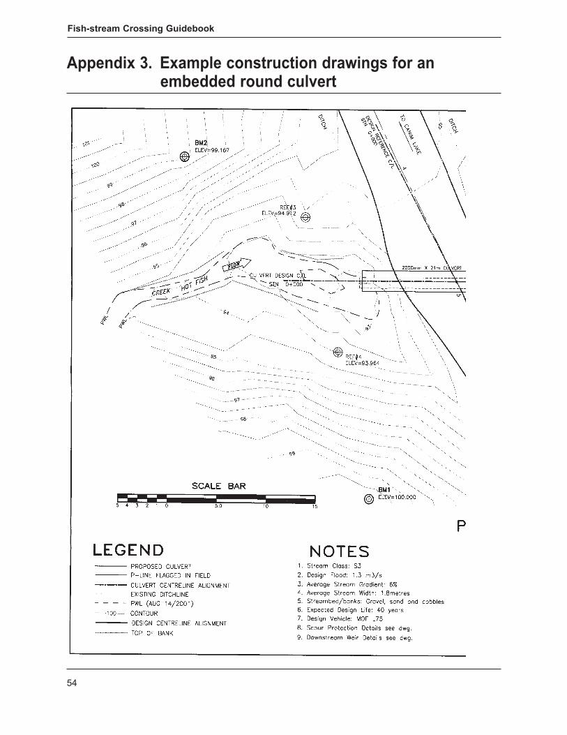
4.2.2 Installationofembeddedclosed-bottomstructuresThe 10 steps below outline the general installation procedures for an embed-ded CBS in fish streams. See Appendix 3 for sample construction drawings of a typical embedded CBS.
1. Assemble in advance – Deliver all required materials and mobilize equipment in advance so that the installation can proceed without delay on a dry bed within the timing window. Appropriate work site isolation techniques (see Section 5.6.1) should be employed during the CBS’s installation. Restrict lay-down areas and storage of materials and equip-ment to the area within the road right-of-way or outside of the riparian zone to minimize disturbance to riparian vegetation and prevent the expo-sure and erosion of soils.
2. Survey – Lay out the work site with precise instruments; this will include establishing the horizontal and vertical field references to accurately locate the culvert invert elevation and slope during construction.
3. Bed preparation – Prepare and grade the culvert bed to conform to the design elevation and slope, using benchmarks and precise instruments. The barrel of the CBS should be set to the appropriate depth below the streambed and at the same natural stream gradient as shown by the longitudinal profile survey. The culvert foundation, trench walls, and backfill should be free of logs, stumps, limbs, or rocks that could damage or weaken the pipe.
Fish-stream Crossing Guidebook
30
4. Seepage barriers – Consider using geotextiles to prevent loss of fines and gravel through seepage along the culvert wall. The fabric, or other cut-off measures such as sandbagging or use of prefabricated seepage barriers along the culvert near the inlet, is intended to cut off most of the seepage and mitigate potential support-fill erosion that can occur along the pipe.
5. Drainage – Do not allow side ditches to drain directly into the stream (see Figure 11). Divert ditch water onto stable forested vegetation that can filter fine sediments before reaching the stream or, if necessary, to a constructed sump. Ensure that adequate cross-drainage is in place before the culvert approach to minimize the water volume directed into approach ditches at culvert sites. Consider the use of rolling grades to divert road surface runoff. Where cross-ditches are used, ensure that these are prop-erly armoured at the outlet and along the base.
6. Constricting the stream – Do not allow any activities, including the placement of riprap, to cause any constriction of the stream channel width.
7. Erosion protection – Minimize disturbed soils within the riparian zone and below the high-water mark of the stream at all times. Begin erosion-proofing all exposed mineral soil as soon as possible after disturbance.
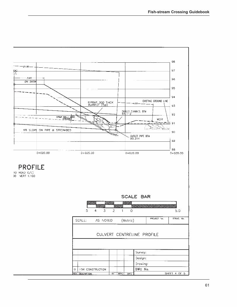
8. Downstream weir – An instream weir (see Figure 8) should be established within 1.5–2 channel widths downstream of the culvert outlet, particularly for streams of greater than 3% gradient, to retain substrate within the cul-vert and to prevent the formation of a plunge pool. The residual pool depth formed by this downstream weir should be less than 0.3 m.
9. Backfill – Backfill practices should conform to those specified by the culvert manufacturer, or otherwise specified by an engineer, and incorpo-rate mechanical vibratory compaction immediately adjacent to the culvert (see Figure 9).
10. 3–6% grade – For culverts installed at slopes greater than 3%, larger mate-rial (D90 or greater) should be mixed into the substrate to help retain the substrate in the pipe. The larger material should be placed so that it projects from the streambed. This should create velocity shadows to enhance fish passage, retain substrate, and simulate conditions of the natural stream.
Fish-stream Crossing Guidebook
31
Weir plan view±30°
Riprap bank scour protection (both sides)
Note gaps between weir boulders to allow water and fish passage
Culvert outlet Boulders projecting from streambed surface —
only three or four boulders projecting
Weir profile view
Approximately two channel widths
Figure 8. Typical downstream weir.
Fish-stream Crossing Guidebook
32
4.3 Snowfills
4.3.1 DesignofsnowfillsSnowfills (see Figure 10) are options that may be considered for seasonal use depending on the site, time of year, and other environmental constraints that may apply.
• Snowfillsareconstructedbyfillingthechannelwithcompactedcleansnow(i.e., free of dirt and debris). Their use should be considered if the stream is dry or the water is frozen to the stream bottom. Culverts can accommodate unanticipated streamflow due to unseasonal thaws. To avoid adverse impact on the stream, remove culverts and snow before spring thaw.
• Snowfillsshouldnotbeconstructedanddeactivatedinamannerthatadversely affects fish or fish habitat at breakup.
• Snowfillsshouldnotrealign,dredge,orinfillthewatercourse(withmate-rial other than clean snow), or result in grading or excavating the bed or bank of the watercourse.
4.3.2 InstallationofsnowfillsThe five steps below outline the general installation procedures for snowfills in fish streams.
1. Construction period – Construct snowfill of dirt-free snow only when sufficient quantities are available for construction. Construction should begin after the stream has frozen solidly to the bottom or the stream has
Figure 9. Culvert backfill compaction.
Fish-stream Crossing Guidebook
33
ceased to flow, or when sufficient ice occurs over the stream to prevent snowloading from damming any free water beneath the ice. Where pos-sible, place snow into the stream channel with an excavator. Crawler tractors may be used to push snow into the stream channel, but only if they can push snow unaccompanied by dirt and debris.
2. Streamflow – Where streamflow is anticipated during periodic winter thaws, place a pipe culvert, or heavy steel pipe within the stream channel to allow for water movement beneath. Heavy steel pipe is easier to sal-vage and has less chance of crushing under load and during removal. The use of log bundles in snowfills and ice bridges is no longer recommended in accordance with Fisheries and Oceans Canada Operational Statement http://www.pac.dfo-mpo.gc.ca/habitat/os-eo/icebridge-pontsduglace-eng.htm.
3. Soil – Do not cap snowfill with soil. Soil placed within the stream chan-nels could make its way into the stream during winter thaws.
4. Temporary removal – Remove any snowfill that may cause damage to the stream because of warmer weather, and reconstruct a new snowfill when colder weather returns.
5. Removal – Remove all snowfills and materials before the spring melt and place materials above the normal high-water mark of the stream to prevent them from causing sediment and erosion. Deactivation should include the use of all appropriate measures to stabilize the site and facili-tate its return to a vegetated state.
4.4 Ice Bridges Ice bridges are effective stream crossing structures for larger northern streams and rivers, where the water depth and streamflow under the ice are sufficient to prevent the structure from coming in contact with the stream bottom (“grounding”), and where spring ice jams are not a concern. Grounding can block streamflow and fish passage and cause scouring of the stream channel.
Figure 10. Temporary winter stream crossings using compacted snowfills. Culverts or heavy steel pipe allow meltwater to pass during warm weather trends.
water, minimum winter daily streamflow, substrate, crossing location, maximum load strength, time of use, depth of ice required, approach con-struction, maintenance and monitoring, and decommissioning.
4.4.2 InstallationoficebridgesThe three steps below outline the general installation procedures for ice bridges in fish streams.
1. Thickness – Measure and record ice thickness and stream depth routine-ly. Evidence of grounding, or an increased risk of the ice base grounding with the streambed, may require that the bridge be temporarily or perma-nently decommissioned.
2. Approaches – Locate ice bridges where cutting into the streambank can be avoided during construction of the approaches. Remove all debris and dirt and place it at a stable location above the high-water mark of the stream. Take steps to prevent it from eroding.
Construct approaches of clean compacted snow and ice to a thickness that should adequately protect streambanks and riparian vegetation. Construction should begin from the ice surface. Where limited snow is available, locally available gravel from approved pits can be used to build up approaches and should be removed when the ice bridge is removed.
When it is time for deactivation, remove all ice bridge approaches and any imported material (e.g., clean gravel on approaches). Where stream-banks have been inadvertently exposed to mineral soil, re-contour and re-vegetate them using all appropriate measures to stabilize the site and facilitate their return to a vegetated state.
3. Water withdrawal – To maintain existing fish habitat, ensure that the withdrawal of water does not exceed 10% of the instantaneous flow.
4.5 Fords Fords may be necessary for one-time access to construct a stream crossing. However, authorizing agencies do not encourage fords established as structures to facilitate multiple crossings, as these structures can result in habitat degrada-tion through sedimentation, channel compaction, and the creation of barriers to fish passage. When a ford is being considered, refer to DFO’s Working Near Water in BC and Yukon website (http://www.pac.dfo-mpo.gc.ca/habitat/index-eng.htm) to determine the necessary referral steps; for petroleum-related oper-ations, refer to the Oil and Gas Commission, and for mining projects, refer to the B.C. Ministry of Forests, Lands and Natural Resource Operations.
5. Fish-stream Protection Measures The practices described below apply to all fish-stream installations.
• Theinstallationofastreamcrossingshouldsimulateconditionssimilartothose that originally existed on the site. Environmental objectives associ-ated with the construction, installation, and use of stream crossings are:
– protecting fish and fish habitat; – providing for fish passage; – preventing impacts on fish eggs and alevin that are present in the
gravel, or on adult and juvenile fish that are migrating or rearing; and – reducing the risk of sediment release and other deleterious substances
during work at stream crossings.
• Toachievetheseobjectives,thefollowingfishandfishhabitatprotectionmeasures are recommended.
– Complete the work during the appropriate instream fisheries work window (see Appendix 1).
– Eliminate or reduce sediment-related problems during installation. – Prevent deleterious substances from entering streams. – Minimize or avoid disturbing fish habitat above and below the area
required for actual construction of the stream crossing. – Ensure that the design specifications for safe fish passage are achieved.– Re-vegetate and stabilize the site to prevent post-construction erosion. – Minimize clearing width at the crossing site and retain streamside
vegetation within the stream crossing right-of-way wherever possible, recognizing operational requirements.
5.1 Vegetation Retention at Stream Crossings • Retainasmuchunderstoreyvegetationaspossiblewithintheriparian
management area of the stream crossing to prevent erosion and mini-mize disturbance to fish habitat. Remove only the vegetation required to meet operational and safety concerns for the crossing structure and its approaches. To assist in post-construction site stabilization, consider sal-vaging rooted shrubs during crossing construction.
• Minimizeimpactstotheriparianfishhabitatatthecrossingsite,includ-ing designing and constructing approaches that are perpendicular to the watercourse to minimize loss or disturbance to riparian vegetation.
• Disposeofconstructionwastesandoverburdenoutsideoftheriparianzone to reduce impacts to riparian vegetation.
5.2 Falling and Yarding • Fallingandyardingoftreesatstreamcrossingscanresultinunnecessary
stream damage. Fall trees away from the stream whenever possible; use
Fish-stream Crossing Guidebook
36
methods of falling, tree removal, and stream cleaning that will minimize potential damage.
• Whereconstructionworkposesariskoferosionandbankdamage,con-sider the use of directional falling and machine-free zones. Where leaning trees are encountered, consider the use of directional falling techniques.
• Wheretreesmustbefelledacrossthestreamforsafetyandoperationalreasons, lift trees rather than drag them out.
5.3 Grubbing and Stripping • Grubbingandstrippingincludestheremovalofstumps,roots,and
downed (non-merchantable) or buried logs. In the riparian management zone, these activities are appropriate only when required for road con-struction, ditchlines, and installation of the crossing structure.
5.4 Slash and Debris • Removeallslashanddebristhatentersthestreamchannelfromfelling
and yarding concurrently with site development. Place this material out-side the riparian management area of the stream and where it cannot be re-introduced into the stream by subsequent flood events. It is not suit-able to dispose of slash or debris within the active floodplain. When stream cleaning, do not remove any hydraulically stable, natural debris. For additional information, see the Forest Practices Code Riparian Management Area Guidebook (1995).
• Undertakeallburying,trenching,scattering,orburningofdebrisoutsidethe stream’s riparian management area. Locate debris piles where these cannot enter the stream (i.e., not in the active floodplain or on steep slopes adjacent to the stream).
crossing (over and back) for each piece of equipment required to facilitate construction on the opposite side. Where additional movement of equip-ment is required, approval may be necessary regardless of habitat type.
• Ifthestreambedandstreambanksarehighlyerodible(e.g.,dominatedbyorganic materials, silts, and silt loams) and significant erosion and stream sedimentation or bank or stream channel degradation may result from heavy-equipment crossings, use a temporary crossing, or other practices, to protect the streambed and banks.
5.6 Erosion and Sediment Control Measures Sediment delivered to stream channels can harm fish and fish habitat. Most sedimentation occurs in the first year when soils are exposed during and
Fish-stream Crossing Guidebook
37
immediately following construction. The amount of sediment generated at a stream crossing is directly related to the sensitivity of the soil to erosion, the amount of area exposed to runoff or streamflow, and the disturbance caused by road construction.
• Preventionofsedimentationbyminimizingdisturbancetostreambanksand retaining riparian vegetation is essential. Many small streams and adjacent worksites are dry during the instream work window, and con-struction can be undertaken without special measures for erosion and sedi-ment control. When water is present, most erosion and sediment problems can be avoided by using various methods that control sediment at the source and prevent it from becoming entrained in the flowing water. The key is to isolate the flowing water from the work.
• Duringperiodsofheavyorpersistentrainfall,suspendworkactivitiesifthese could result in sediment delivery that would adversely affect the stream’s aquatic resources. During such a shutdown period, implement measures to minimize the risk of sediment delivery to the stream.
Common methods for reducing erosion during and after construction are described below.
5.6.1 WorksiteisolationWorking “in the dry” can greatly facilitate installation construction and reduce the amount of sediment produced during the work. To isolate a site, consider using the following techniques.
• Onsmallstreamsorwhereflowsareverylow,pipes,flumes,orero-sion-proofed ditches may be adequate to divert flow around the site. To minimize sediment loss from and along the diversion, install sediment traps along with geotextiles at these sites.
• Alwaysexcavatetemporarystreamdiversionsinisolationfromstream-flow, starting from the bottom end of the diversion channel and working upstream to minimize sediment production. To prevent loss of sediment, leave the bottom end of the diversion channel intact until the trench is almost complete; do not open until all measures have been taken to reduce surface erosion resulting from the channel. After completing the stream crossing, close the diversion from the upstream end first; on com-pletion, take actions to re-establish the pre-diversion conditions and to stabilize and re-vegetate the site.
• Wherepractical,pumpwateracrosstheworksiteanddischargeitintothe stream channel below the site. This technique requires the stream to be dammed above the construction site and eliminates the need for a diversion channel, greatly reducing the problems of sediment production associated with digging and operating a newly created stream channel.
Fish-stream Crossing Guidebook
38
Place screens over pump intakes to prevent entrainment of juvenile fish. In all pumping situations, backup pumps on site are highly recommended.
For more information on fish-screening, see the Freshwater Intake End-of-Pipe Fish Screen Guideline (Department of Fisheries and Oceans 1995) available at: http://www.dfo-mpo.gc.ca/Library/223669.pdf.
5.6.1.1 Coffer dams
• Cofferdamsmayberequiredtoisolateworkfromthestreamflow.Thesestructures should not reduce the stream channel width by an amount that could lead to erosion of the opposite banks or of upstream and downstream areas. Coffer dams can be constructed in various ways. For example, sand-bags lined with geotextiles or rubber aqua dams can be used.
• Removeallmaterialsafterconstructioniscompleted.Toallowsedimentto settle before the water re-enters the stream, discharge all sediment-laden water pumped from contained work areas within coffer dams to a forested site.
salvage fish from the affected areas and return them to the stream. Fish sal-vage is the relocation of live fish from a work site to a safe location above or below the site. Fish salvage requires a Scientific Fish Collection Permit which can be obtained from the BC Ministry of Environment (www.env.gov.bc.ca/fish_data_sub). Salvage operations require the isolation of the work site and the collection and removal of all fish from areas where fish may be entrapped or destroyed by construction activities. Fish can be col-lected through the use of electrofishing equipment, small nets, and seines.
Note: If the salvage operations include the collection and relocation of SARA-listed species, please clearly note this in your application for a Scientific Licence (fish collection), as additional authority is required pursuant to the Species at Risk Act.
stabilization through prompt re-vegetation is the most cost-effective, long-term surface erosion control method because it controls sediment at the source. The various planning and practices regulations under the Forest and Range Practices Act take different approaches on vegetation. Regulations specify limits on disturbance of mineral soil exposed during harvesting and road construction for forest tenure holders. Rehabilitation, including re-vege-tation, is required where those limits are temporarily exceeded. Generally, woodlot holders and range tenure holders are subject to re-vegetation require-
ments on disturbed areas where sedimentation is an issue within 2 years.
• Re-vegetatingapproachditches,cutslopes,andotherdisturbedareasreduces the possibility of stream sedimentation. Undertake these activities immediately following completion of work. Standard re-vegetation tech-niques include hand-broadcast or hydraulic seeding, and mulching using regionally adapted seed and mulch mixes.
5.6.3.1 Seeding and time of application
• Selectseedmixesthatarelesspalatabletolivestockandwildlifetomini-mize animal activity at the crossing site. Use seed mixtures that contain 100% native species where available. A list of invasive species can be found in Section 2 of the Invasive Plants Regulation under the Forest and Range Practices Act.
• Timeofseedapplicationisdeterminedlargelybycompletiontimeofthestream crossing installation. Seed all exposed soils near the stream cross-ing installation immediately following completion of construction, and re-seed the site, if necessary, during the regularly scheduled road con-struction seeding program. Hydro-seeding is the most efficient means for seeding steeper slopes.
• Mulchingacceleratesseedlingdevelopmentandreducesthechanceofseed being washed away by rainfall and runoff. When combined with hand-broadcast seeding, straw is a fast and cost-effective mulch substitute for dealing with smaller exposed areas near stream crossings. Seed and mulch can be applied by hand, independent of the seeding schedule, or by the method established for the rest of the road system. This practice can accelerate re-vegetation at higher-risk locations.
• Fibre-bondingagentsareslurriesofwoodfibresandtackifiersthatcon-form to the ground and dry to form a durable, continuous erosion control blanket, which stays in place until vegetation is established. The fibre mats created are biodegradable and decompose slowly as vegetation is re-established. Like other forms of mulching, bonded fibre matrices hold seed and fertilizer in place, yet allow sunlight and plants to penetrate. Compared to conventional erosion control blankets, these materials require no manual labour to install and are not subject to under-rilling or tenting, as can occur with erosion control matting and netting.
gradable netting material such as jute (woven fibres) are other effective methods for speeding germination and plant growth, and for holding materials in place. Stakes fix the matting or netting in place and can be
Fish-stream Crossing Guidebook
40
made to overlie most slope angles adjacent to stream crossings. Jute net-ting may also be used to hold mulch and other materials in place, although it provides little, if any, soil protection.
tions for erosion control (e.g., silt fences, straw bales), followed by bio-engineering techniques. See Polster (1997) for examples of bioengineer-ing solutions.
ditch water is being diverted from an approach ditchline and discharged onto erodible soils or fills. Ditches lined with riprap, shot rock, or large gravel are an effective method for reducing erosion at approaches to stream crossings. Riprap slows the velocity of ditch water and armours erodible ditch bed materials.
• Useripraporrockthatisfreeofsilt,overburden,debris,orothersub-stances deleterious to fish. The material should be durable and sized to resist movement by overland flow. If riprap is not available, temporarily use fabric linings at approaches and culvert spillways.
5.6.7 Drainage control • Drainagecontroliscriticaltothesuccessfulretentionofsedimentsboth
during and after construction (Figure 11) and needs to be considered in relation to the existing drainage pattern on the site. A site sketch plan is the best tool to work with when developing a drainage control plan. Three effective steps in reducing water-related problems are: (1) reducing the volume of approach ditch water, (2) preventing ditch water from draining directly into the stream, and (3) ensuring that the approaches on either side of the bridge slope away from the bridge deck where practicable.
• Tominimizetheseproblems,placecross-drainculvertsintheroadatalocation that allows as much of the water to be diverted away from the stream crossing as possible. This minimizes the length of the approach ditch that contains water, and the amount of ditch open to erosion. Breach any berms that may be present, and dig tail-out ditches to carry the water off the road-clearing width. Ensure that effective ditch blocks are present. Construct ditch blocks of material sufficient to withstand the erosive forces of the anticipated amount of water carried by the ditch.
Avoid draining ditch water directly into the stream. Divert ditch water onto stable forested vegetation or, if that is not possible, construct a sediment trap or basin to filter fine sediments before reaching the stream.
more difficult to manage. Sediment traps and basins, silt fences, straw bale dikes and basins, and geotextiles can prevent coarse material from entering the watercourse, although these methods have limited effective-ness in capturing 1 mm or smaller sediment. For further information, refer to the publications listed at the end of this document.
• Oncompletionofconstruction,thesetemporarycontrolstructuresshouldbe removed and the sediment stabilized.
5.6.8.1 Sediment traps or basins
• Sedimenttrapsorbasinsusedonforestryroadsareexcavatedpitsthatcapture coarse sediment from ditchlines before it can enter a stream. Sediment traps and basins can be either simple, small pits or complex, engineered structures designed to impound large quantities of sediment. To maintain effectiveness, clean all sediment traps and basins frequently. At the crossing site, direct ditch water into the sediment trap or basin.
5.6.8.2 Silt fences
• Siltfencesareshort-termstructuresmadeofwoodorsteelfencepostsanda suitable permeable geotextile. These structures retain coarse-textured sediment on the site and reduce runoff velocity across areas below the fence. Silt fences are effective boundary-control devices and can be used to intercept soil from cutslopes and ditchlines, and to isolate the general work area from the stream. Although intended to prevent sediment from entering channelized flows, silt fences should never be used as filters within a watercourse because of their limited capacity to pass water.
• Afterworkiscompleted,removesiltfencestructurescarefullytopreventthe sediment retained from entering the watercourse or being remobilized during the next rain event.
5.6.8.3 Straw bales
• Strawbalesarebestsuitedwheretemporary,relativelyminorerosioncontrol is needed while more permanent solutions are being devised. When properly used, straw bales can effectively intercept sheet flow run-off at the base of an exposed cutbank, fillslope, or swale, or can act as a check dam in the ditchline of a road. Do not stack bales, but instead take care to properly embed them in the soil. Also, ensure that noxious weeds and non-native grasses are not spread as a result of using straw bales. Avoid using hay bales as these contain more seeds than straw bales.
Fish-stream Crossing Guidebook
43
5.7 Handling Hazardous Substances It is important to know and comply with all regulations governing the stor-age, handling, and application of substances that can be deleterious to fish, including wood preservatives, paints, fuel, lubricants, and fertilizers. For information on the proper use of wood preservatives, see Guidelines to Protect Fish and Fish Habitat from Treated Wood Used in Aquatic Environments in the Pacific Region (Hutton and Samis 2000).
• UncuredconcreteorgroutcankillfishbyalteringthepHofthewater.Use pre-cast concrete and carefully protected grout to eliminate the risk to fish. However, when cast-in-place concrete is required, perform all work “in the dry” and effectively isolate the site from any water that may enter the stream for a minimum of 48 hours.
• Storeallfuels,lubricants,andothertoxicmaterialsoutsidetheriparianmanagement area of the stream, in a location where the material can be contained. Check equipment for leaks of hydraulic fluids, cooling system liquids, and fuel; equipment should be clean before fording. Also, per-form all fueling operations outside of the riparian management area.
• Developacontingencyplanfortheuseofallhazardousmaterials,includ-ing spill containment, clean-up, and notification of the appropriate regu-latory agencies and water purveyors in the event of a problem. Retain spill kits, sorbents, and containers for disposal on site.
Fish-stream Crossing Guidebook
44
6. Maintenance Practices All stream crossings and sediment control structures require inspection and maintenance.
• Thefrequencyofinspectionsshouldbecommensuratewiththeriskofdamage to the structure from major storm or runoff events affecting the fisheries resource. Areas prone to serious debris or bedload problems require special consideration and should be accounted for in the choice of structure and inspection frequency.
• Inspectandmaintainstreamcrossingsandcontrolstructuresregularlytoensure that they:
– protect fish and fish habitat, – maintain safe fish passage, and – reduce the risk of releasing sediment or other deleterious substances.
• Itisgoodpracticetoclearlymarkallcrossingsonfishstreams,allowingmaintenance staff to readily identify them. When the operation has a road inventory system, mark all fish-stream crossings on the map or electronic database.
• Ifinspectionrevealsanongoingmaintenanceproblem,thenconsiderredesigning and replacing the structure to meet fish passage and fish hab-itat objectives.
or upgrading of existing scour protection, may potentially affect fish and fish habitat. If a road permit or Approval is held under the Forest and Range Practices Act, refer to Section 79 of the Forest Planning and Practices Regulation and consult DFO’s Working Near Water in BC and Yukon website (http://www.pac.dfo-mpo.gc.ca/habitat/index-eng.htm) for the most up-to-date bridge maintenance guidelines and procedures.
• Large-scalemaintenanceactivitiesthatmayalterinstreamfishhabitat,such as dredging or the placement of new riprap or fills below the high-water mark, usually constitute changes in and about a stream that may require a regulatory Approval (refer to Section 3).
• Gravelandsedimentcangetdraggedontothebridgefromroutinegrad-ing. Care should be exercised to prevent this gravel and sediment from entering the stream either directly from the bridge surface or indirectly
from material pushed over the edge along the approaches. Several methods can be used to address this issue.
– Gravel guards can be installed along the edge of the bridge rails to prevent the gravel and sediment from entering the stream. The bridge rails typically have open spaces between the fasteners of the rail where sediment can enter the stream.
– Approaches can be paved. – Curbs can be installed along the bridge approaches. – Grading away from the bridge can be done.
6.2 Open-bottom Structures and Embedded Closed-bottom Culverts • Inspectculvertstoensurethattheyprovidesafefishpassageandprotect
fish and fish habitat above, below, and at the culvert. Conduct inspections immediately before the period of seasonal high stream flows, following any major storm event, and, safety permitting, during these flows or events. Check all installations to ensure that they are functioning follow-ing construction and seasonal deactivation.
• Rectifyanymaintenanceproblemswithculvertsassoonaspossibletorestore normal function and prevent damage to the site or stream. To pre-vent further impacts to the watercourse, conduct all instream work required to rectify major problems following the recommendations in Section 5.
• Forfurtherguidanceforculvertmaintenance,seeDFO’sCulvert Maintenance Operational Statement available at http://www.pac.dfo-mpo.gc.ca/habitat/os-eo/culvert-ponceau-eng.htm.
The following common concerns related to culverts should be addressed.
• Substrate – Inspect embedded closed-bottom culverts constructed in accordance with this guidebook to ensure that stream substrate is retained. If inspection reveals that substrate is not being retained, re-evaluate the original design parameters. Simply replacing streambed substrate within a culvert is not acceptable, without first identifying and rectifying the cause of substrate loss, as it may affect downstream fish habitat by causing pool infilling. The design discharge must also be maintained. An outlet control such as a weir may facilitate substrate retention. To ensure that substrates are retained, add some large rock in an interlocking manner to the sub-strate within the culvert barrel.
When water is flowing in the stream, make sure that the depth of water in the pipe above the substrate is similar to the depth upstream and down-stream of the culvert. It may be necessary to add one or more weirs to a culvert to help retain the substrate within the culvert and so ensure that the stream flows above the substrate, particularly at low flows.
• Fish passage – Several problems arise with non-embedded CBSs. One of the most serious is scouring at the outlet, which results in a perched outlet. This frequently renders the structure impassable to fish. New embedded culvert design and construction techniques should avoid this problem. However, in areas where proponents have responsibilities for existing culverts that lack fish passage capability, the culverts should be assessed and appropriate actions taken to restore fish passage. This may require reconstruction of the culvert or modification of the site by back-watering or through baffle or weir installation to achieve passage flows.
When baffles or weirs are proposed, specific biological and engineering input is required. Inspect all retrofitted culverts to ensure that these are functioning. Baffles and weirs are prone to clogging with debris and sedi-ment, and can be ripped out, damaging the culvert or even causing it to fail. They are also known to disrupt the boundary layer, resulting in impaired juvenile fish passage.
• Plugging from upstream debris – Unless debris is limiting the move-ment of water and (or) the passage of fish, plan to remove debris using the fisheries timing windows (see Appendix 1) to prevent disruption to sensitive fish life stages. When clearing debris, limit the amount of sedi-ment entering the watercourse. Remove small accumulations of debris by hand. If using machinery, operate it on land above the high-water mark. If necessary, build properly designed “trash racks” to accommodate fish passage. These may require frequent maintenance. If debris is a persistent problem, consider replacing the structure to permit natural bedload and debris movement.
• Beaver dams at the inlet – Beaver dams at culvert inlets can prevent fish passage as well as threaten roads and, thus, frequent maintenance is required. In some areas, persistent beaver problems will be a significant influence on design choice. Bridges are less prone to beaver problems than are culverts. For more information on beaver dam removal, refer to provincial best management practices at: http://www.env.gov.bc.ca/wld/instreamworks/beaverdamremoval.htm.
• Icing – In northern areas where ice blocks a culvert and threatens to flood a road, modification of inlet conditions or de-icing (through the use of steam) may be required.
6.3 Sediment Control Sediment control is an issue when maintaining roads near fish streams. For example, cleaning ditches adjacent to the stream, or grading or cleaning the deck of a crossing structure, can result in the deposit of sediment into a fish stream. During maintenance operations, the following activities are recom-mended to control sediment.
• Instructgraderoperatorsnottobladematerialintostreams.Alternatively,consider the use of containment logs to prevent sediment from entering the streams.
• Maintaintheexistingvegetationinsidetheditchclosesttothestreamtoallow for filtering of sediment.
• Ensurethatcross-drainsandditchblocksarefunctioning,androadditch-es continue to discharge as designed. Inspect all drainage areas to ensure that sediment-laden water is being discharged appropriately and not erod-ing a new channel to the stream.
• Maintainvegetationbyhydro-seedingordryseedingandfertilizing,orby placing sediment and erosion-control matting over road cuts and fills where problems are seen to occur. Spot-seeding to fill in gaps left during seeding programs is quick, easy, and extremely effective in controlling small problems before they escalate.
• Wherepossible,ensurethatditchoutflowsnearthecrossingdischargeonto a vegetated area, or into a sump or other sediment control device, and not directly into the stream itself.
• Maintainorre-installpermanenterosioncontrolmeasuresinstalledatthetime of construction. Additional structures may be required to adequately control sediment.
ings (including the deactivation of old sites adjacent to a new crossing) can be avoided or mitigated by activities that:
– protect fish and fish habitat; – provide for fish passage; – prevent impacts to fish eggs and alevins that are present in the gravel,
or to adult and juvenile fish that are migrating or rearing; and – reduce the risk of releasing sediment and other deleterious substances
during work at stream crossings.
• Barringspecificaccessplanningobjectivestoclosearoad,retaincross-ing structures where continued access is required after deactivation.
• Theobjectivesbehindstreamcrossingdeactivationareto:(1)restoretheoriginal habitat components to pre-crossing conditions, and (2) close the road to future access. These conditions can be observed in the nearest unmodified section of the stream immediately upstream or downstream of the crossing.
• Whenplanningfordeactivationisunderway,treatallcrossingswherethe stream gradient is less than 20% as fish streams unless specifically identified as being non-fish streams. Thus, a more detailed deactivation plan that takes fish protection into account should be prepared. The assumption is that if culverts are removed and the stream channel is re-configured, fish passage is ensured, as long as the deactivation is carried out correctly.
• Deactivationaroundfishstreamscancreatespecialproblems.Thelarg-est is the control of sediment from deactivation operations. As with construction, deactivation requires a sediment control plan and good implementation. Care should be taken to safely place the fill removed during deactivation; end hauling may be necessary. To prevent sedimen-tation, perform all work “in the dry”; habitat features should be restored and the resulting channel should stabilize before water is re-introduced to the restored channel.
• Manyoftheguidelinesoutlinedforconstructionpractices(Section5)also apply to deactivation activity. Particular attention should be paid to those guidelines that relate to sediment control and re-vegetation.
Fish-stream Crossing Guidebook
49
PART 3: Assessment and Restoration of Fish Passage at Culvert-stream Crossings
8. Fish Passage Assessment Procedure The provincial/federal Fish Passage Technical Working Group identifies pri-ority watersheds for fish passage assessments and priority stream crossing for remediation. For more information, visit the Fish Passage program website at: http://www.for.gov.bc.ca/hcp/fia/landbase/standards/fishpassage.htm and the Technical Working Group website at: http://www.for.gov.bc.ca/hfp/fish/FishPassage.html.
8.1 Strategic Approach A five-phase procedure (Figure 12) is in place to assess and prioritize the res-toration of fish passage at culvert-stream crossings in British Columbia. It was designed to ensure that a systematic, watershed-based approach was available that could be implemented at various scales while maintaining provincial applicability. The summary presented here outlines the various phases of the assessment process. Because this process will continue to evolve, the current version of the protocol, field methodology (Phase 2, Figure 12), and data sources are posted online at http://www.for.gov.bc.ca/hcp/fia/landbase/ standards/fishpassage.htm. Updates will be posted as these become available.
The objective of this approach is to conduct a systematic assessment of all closed-bottom structures in a defined area to restore fish passage in a cost-effective manner. The first phase of the process involves planning and prepa-ration to ensure that assessment efforts are focussed where fisheries values are the highest. The data collection portion of the process contains a relative-ly simple, quick, and efficient field assessment. The third phase involves analysis of the data collected, leading to the development of an implementa-tion plan (restoration phase) with input from local technical experts and users of the subject road network and its associated stream crossings. The final phase involves the evaluation of the collected data and reporting.
8.1.1 PlanningphaseThe planning phase of this protocol is intended to focus assessment work in pri-ority watersheds and prepare for the assessment fieldwork. The extent of the study area and the allocated budget will be determined by the agency, licensee, or individual undertaking the assessments. The process is meant to provide flex-ibility while ensuring that work is done within high-priority fish areas in a given study area. Selecting large areas, with as much co-operation between jurisdic-tions or tenure holders as possible, is obviously advantageous as this will help to identify problem structures with the highest cost/benefit for restoration.
8.1.2 DatacollectionphaseThe systematic review of culverts in the selected priority areas ensures that all closed-bottom structures on fish streams are assessed. The procedure to complete this phase is detailed in the Field Assessment for Determining Status of Closed Bottom Structures (see http://www.for.gov.bc.ca/hcp/fia/landbase/standards/fishpassage.htm). This methodology uses a series of hydraulic surrogate indicators (i.e., outlet drop, culvert slope, culvert diame-ter vs. channel width) to assess fish passage. A fish barrier scoring system, based on fish swimming science, is then used to determine the likelihood that the assessed culvert is a barrier to safe fish passage.
8.1.3 AnalysisphaseAfter the data are collected, the analysis phase produces a ranked list of sites for restoration consideration. This analysis focusses on fish streams that have a high probability of fish presence and determines the amount of habitat gained upstream, along with associated costs. This phase ensures that restora-tion will achieve its greatest benefit.
1. Planning Phase
3. Analysis Phase
4. Restoration Phase
5. Reporting Phase
2. Data Collection Phase
Informs
Provideinformation to
Select watershed(s) using “Fish Values” and
1:50,000 Watershed
Atlas Polygons
Prepare mapsshowing roadnetworks and
known fishdata
FishPassage
DataAnalysis
ImplementationPlan
Restore FishPassage
Report andEvaluate
PrioritizedList
RegionalInput
Conduct Protocolfor Fish PassageDetermination ofClosed-Bottomed
Structuresto determine
potentialbarrierNo
Yes
No furtheraction
Figure 12. Overview of the five-phase provincial procedure for assessing and prioritizing the restoration of fish passage at culvert-stream crossings.
8.1.4 RestorationphaseIn this step, information from the analysis phase is used to develop an implementation plan that will ensure the greatest return of fish habitat for the money spent. This plan outlines the structures that will be restored and proposes a schedule to undertake the work.
This phase should take place at the regional or sub-regional level and involve all affected parties that have an interest in maintaining or using the road. Ideally, this will include those who have done the assessment work. Decisions are made concerning which structures should be fixed or removed (along with road deactivation). Local expertise in fisheries/habitat biology and engineering should be used to develop implementation plans.
After the implementation plan is complete, a more detailed costing will be required for restoration to proceed; with funding in place, contracts will be awarded and schedules finalized. The implementation plan should be reviewed annually, updated, and endorsed by affected parties as new infor-mation becomes available.
8.1.5 ReportingandevaluationphaseThe final phase of this approach is the reporting and evaluation phase. Information collected during the data collection phase should be entered into the provincial database. To assess the effectiveness of this approach, a subset of restored structures should then be evaluated using the same field method-ology outlined above.
Fish-stream Crossing Guidebook
52
APPENDICES
Appendix 1. Instream work window for provincial fisheries zonesConstruction work, as well as deactivation and restoration, should be com-pleted during the appropriate instream work window. Information on specific instream work windows should be obtained from your regional B.C. Ministry of Environment and Fisheries and Oceans Canada offices or through the fol-lowing websites: http://www.pac.dfo-mpo.gc.ca/habitat/timing-periodes/index-eng.htm or http://www.for.gov.bc.ca/hfp/fish/FishPassage.html. Freshwater timing windows are specific to Ministry of Environment regions. A map of Ministry of Environment regions can be viewed at: http://www.env.gov.bc.ca/main/regions.html.
• Timingwindowsarespecifictofishspeciesandthegeographicareawithin which the work is conducted. This period of least risk is deter-mined by such factors as the time when there are no known fish eggs or alevins (pre-emergent fry) present in the stream substrate, and when streamflow is low and soil conditions are dry.
• Duringtheplanningofinstreamwork,allofthefishspeciespresentinastream should be considered. Depending on the mix of species present, there can be overlapping constraints on the timing of operations. The fol-lowing conditions, if met, result in a year-long timing window (i.e., January 1–December 31).
– The structure does not encroach into the stream channel width, no work is proposed that disturbs the bed or banks of a fish stream or fisheries-sensitive zone, and the risk of sediment delivery is low.
– The work is on a non-fish stream and the appropriate measures should be taken to prevent the delivery of sediments into fish habitat.
– During construction, modification, or deactivation activities, the stream channel at the crossing is naturally completely dry.
– Construction, modification, or deactivation activities on a non-fish stream that is a direct tributary to a fish stream are carried out by isolating the work area, and keeping dry conditions by temporari-ly pumping, or otherwise diverting, the flow around the work site while instream activities occur.
• Duringatimingwindow,juvenileoradultfishmaystillbepresentonsite.This is generally the case for resident fish species and for those fish that reside in streams for a period of time before migrating to other areas. For this reason, construction should stop any time unfavourable soil moisture or rainfall conditions are anticipated to exceed an operation capability for sediment control. Work should not resume until conditions permit. Indicators that sediment control capacity has been exceeded include dirty ditch water, mud holes, and unstable road cuts near the stream.
• Ifatimingextensionisrequired,arequestmustbemadetotheissuerofthe original works authorization.
Appendix 2. Methodology for determining stream channel width
Stream channel width is the horizontal distance between the streambanks on opposite sides of the stream, measured at right angles to the general orienta-tion of the banks. The point on each bank from which width is measured is usually indicated by an observable change in vegetation and sediment tex-ture. This border is sometimes shown by the edges of rooted terrestrial vege-tation. Above this border, the soils and terrestrial plants appear undisturbed by recent stream erosion. Below this border, the banks typically show signs of both scouring and sediment deposition.
Recommended approach (see Figure 7)
• Avoidmakingstreamwidthmeasurementsatunusuallywideornarrowpoints along the stream, or in areas of atypically low gradient such as marshy or swampy areas, beaver ponds, or other impoundments.
• Avoidmeasuringchannelwidthindisturbedareas.Channelwidthscanbe increased greatly by both natural and human-caused disturbances. These disturbances include those caused by recent exceptional flood events, debris torrents, machines and yarding, and even existing crossing structures. (See the Forest Practices Code Riparian Management Area Guidebook [1995] for descriptions of disturbed channels.)
1. Use fibre survey chain at least 50 m long. Include all unvegetated gravel bars in the measurement (these usually show signs of recent scouring or deposition).
2. Where multiple channels are separated by one or more vegetated islands, assume that the width is the sum of all the separate channel widths. Exclude the islands from the measurement.
3. Calculate the width of the stream reach by averaging at least six sepa-rate width measurements taken at equally spaced intervals along a 100-m length of the stream profile (i.e., 50 m upstream and down-stream of the crossing site).
4. Always determine the undisturbed channel boundary. If there is evi-dence of disturbance, then: – move either upstream or downstream to points along the stream
that do not show signs of disturbance (e.g., where banks are not eroded); or
– use the boundary of recently recolonized vegetation (e.g., alder, aspen, cottonwood).
Fish-stream Crossing Guidebook
54
Appendix 3. Example construction drawings for an embedded round culvert
Fish-stream Crossing Guidebook
55
Fish-stream Crossing Guidebook
56
Appendix 3. (continued)
Fish-stream Crossing Guidebook
57
Fish-stream Crossing Guidebook
58
Appendix 3. (continued)
Fish-stream Crossing Guidebook
59
Fish-stream Crossing Guidebook
60
Appendix 3. (continued)
Fish-stream Crossing Guidebook
61
Fish-stream Crossing Guidebook
62
Appendix 3. (concluded)
Fish-stream Crossing Guidebook
63
Fish-stream Crossing Guidebook
64
GLOSSARY
Alevin Young fish with the external yolk sac still attached.
Critical (As defined by the Species at Risk Act) includes the habitat that is necessaryhabitat for the survival or recovery of a listed wildlife species and that is identified as
the species’ critical habitat in the recovery strategy or in an action plan for the species.
Fish All fish, shellfish, crustaceans and marine animals, and the eggs, spawn, spat and juveniles of fish, shellfish, crustaceans and marine animals (Fisheries Act).
Fish habitat The spawning grounds, nursery, rearing, food supply and migration areas on which fish depend directly or indirectly in order to carry out their life process-es (Fisheries Act).
Fish stream A watercourse that: a. is frequented by any of the following species of fish: (i) anadromous salmonids; (ii) rainbow trout, cutthroat trout, brown trout, bull trout, Dolly Varden
char, lake trout, brook trout, kokanee, largemouth bass, smallmouth bass, mountain whitefish, lake whitefish, arctic grayling, burbot, white sturgeon, black crappie, yellow perch, walleye or northern pike;
(iii) a species identified as a species at risk; (iv) a species identified as regionally important wildlife, or
b. has a slope gradient of less than 20%, unless the watercourse (i) does not contain any of the species of fish referred to in paragraph (a), (ii) is located upstream of a barrier to fish passage and all reaches upstream
of the barrier are simultaneously dry at any time during the year, or (iii) is located upstream of a barrier to fish passage and no perennial fish
habitat exists upstream of the barrier (Forest Planning and Practices Regulation under the Forest and Range Practices Act).
High-water The visible high-water mark of any lake, stream, or other body of water mark where the presence and action of the water are so common and usual and so
long continued in all ordinary years as to mark upon the soil of the bed of the lake, river stream, or other body of water a character distinct from that of the banks, both in vegetation and in the nature of the soil itself. Typical features may include a natural line or “mark” impressed on the bank or shore, indicated by erosion, shelving, changes in soil characteristics, destruction of terrestrial vegetation, or other distinctive physical characteristics. In situations where it is possible to determine a flood frequency interval, this definition corresponds to the 1:5 flood interval or corresponding elevation.
Navigable Any waters capable of being used for commerce, transportation, or recreation.water Navigability can be determined only by Transport Canada.
Fish-stream Crossing Guidebook
65
Reach The Fish-stream Identification Guidebook (1998) defines a “reach” as a water-course that has a continuous channel bed that meets one of the following requirements:
a. the channel bed is at least 100 m in length, measured from any of the fol-lowing locations to the next of any of the following locations:
(i) the location where the watercourse begins or ceases to have a continu-ous channel bed;
(ii) the location where (A) a significant change in morphology occurs; for example, at the
junction of a major tributary, and (B) the mean width of the channel bed, as measured over a representa-
tive 100 m length of channel bed, upstream and downstream of the morphological change, is sufficient to change the riparian class of the watercourse, if the watercourse were a stream;
(iii) the location where (A) a significant change in morphology occurs; for example, at the
junction of a major tributary, and (B) the mean gradient of the channel bed, as measured over a repre-
sentative 100 m length of channel bed upstream and downstream of the morphological change, changes from less than 20% to 20% or more, or vice versa;
b. the channel bed is at least 100 m in length, made up of one or more seg-ments, the boundaries of which are any of the locations referred to in para-graph (a).
c. the channel bed is less than 100 m in length, if the continuous channel bed (i) is known to contain fish, (ii) flows directly into a fish stream or a lake that is known to contain fish,
or (iii) flows directly into a domestic water intake.
Residence The Species at Risk Act defines a “residence” as a dwelling-place, such as a den, nest, or other similar area or place, that is occupied or habitually occupied by one or more individuals during all or part of their life cycles, including breeding, rearing, staging, wintering, feeding, or hibernating.
Stream The Forest and Range Practices Act defines a “stream” as a watercourse, including a watercourse that is obscured by overhanging or bridging vegetation or soil mats, that contains water on a perennial or seasonal basis, is scoured by water or contains observable deposits of mineral alluvium, and that:
a. has a continuous channel bed that is 100 m or more in length, or b. flows directly into (i) a fish stream or a fish-bearing lake or wetland, or (ii) a licensed water works.
Stream The Fish-stream Identification Guidebook (1998) defines “stream channel channel width” as the horizontal distance between the streambanks on opposite sides of
Fish-stream Crossing Guidebook
66
the stream, measured at right angles to the general orientation of the banks. The point on each bank from which width is measured is usually indicated by an observable change in vegetation and sediment texture. This border is some-times shown by the edges of rooted terrestrial vegetation. Above this border, the soils and terrestrial plants appear undisturbed by recent stream erosion. Below this border, the banks typically show signs of both scouring and sedi-ment deposition.
Fish-stream Crossing Guidebook
67
REFERENCES AND RECOMMENDED ADDITIONAL READING
Information and guidelines from many sources were incorporated in the development of this guidebook. See the following references for more infor-mation on assessment procedures, hydraulic design, and best management practices.
Fish Passage Technical Working Group. http://www.for.gov.bc.ca/hfp/fish/FishPassage.html.
FishXing. http://stream.fs.fed.us/fishxing.
Oil and Gas Commission’s Environmental Protection and Management Guide (March 2012). http://www.bcogc.ca/industryzone/forms/stewardship.aspx.
Forest and Range Evaluation Program: Fish/Riparian. http://www.for.gov.bc.ca/hfp/frep/values/fish.htm.
Slaney, P.A. and D. Zaldokas (editors). 1997. Fish Habitat Rehabilitation Procedures. Watershed Restoration Technical Circular No. 9. Watershed Restoration Program, BC Ministry of Environment, Lands and Parks.http://www.env.gov.bc.ca/wld/documents/wrp/wrtc_9.pdf.
ReviewProcessFisheries and Oceans. 1998. Decision framework for the determination and
authorization of harmful alteration, disruption or destruction of fish habi-tat. Habitat Manag. Br., Ottawa, Ont. DFO/5531. http://www.dfo-mpo.gc.ca/Library/231028.pdf (Accessed November 2010).
SiteAssessmentTechniques/StreamHydrologyHicks, D.M. and P.D. Mason. 1991. Roughness characteristics of New
Goldman, S.J., K. Jackson, and T.A. Bursztynsky. 1986. Erosion and sedi-ment control handbook. McGraw-Hill, Inc., New York, N.Y.
FishPassageGuidanceandDesignCriteriaAmerican Iron and Steel Institute. 1994. Handbook of steel drainage and
highway construction products. 5th ed. American Iron and Steel Institute, Washington, D.C.
Bates, K. 1992. Fishway design guidelines for Pacific salmon. Washington Dep. Fish and Wildl., Olympia, Wash.
Dane, B.G. 1978. Culvert guidelines: recommendations for the design and installation of culverts in British Columbia to avoid conflict with anadro-mous fish. Can. Dep. Fish. and Oceans. Fish. Serv., Vancouver, B.C. Tech. Rep. No. 811.
Oregon Department of Fish and Wildlife. 1995. Interim fish passage guid-ance at road crossings. Memorandum to field dated June 16, 1995, pro-vided by E.G. Roberson, Hydrologist, Oreg. Dep. For., 2600 State Street, Salem, Oreg.
StreamSimulationforCulvertInstallationsKatopodis, C. 1993. Fish passage at culvert highway crossings. Presentation
notes, “Highways and the Environment.” Can. Dep. Fish. and Oceans. Freshwater Institute, Winnipeg, Man.
McKinnon, G.A. and F.N. Hnyka. 1993. Fish passage assessment of culverts constructed to simulate stream conditions on Liard River tributaries. Can. Dep. Fish. and Oceans. Freshwater Institute, Winnipeg, Man. Tech. Rep. No. 1255.
Robison, E.G. and M. Pyles. 2001. Forest road stream crossing design guide. Oreg. State Univ., For. Eng. Dep., Corvallis, Oreg.
CulvertStudiesBell, M.C. 1986. Fisheries handbook of engineering requirements and bio-
logical criteria. U.S. Army Corps of Engineers, North Pacific Division, Portland, Oreg.
Fitch, G.M. 1997. Designing highway culverts that do not impede the move-ments of resident fish species. Road Eng. J. Nov. 1, 1997.
Road Location and LayoutFurniss, M.J., S.A. Flanagan, J. Ory, K. Moore, and T.S. Ledwith. 1999.
Watershed-scale road stream crossing risk assessment. U.S. Dep. Agric. For. Serv., Six Rivers National Forest, McKinleyville, Calif. http://www.watershed.org/?q=node/219.
Holmes, D.C. 1989. Manual for roads and transportation. Vol. II. Revised ed. B.C. Inst. Technol., Burnaby, B.C.
BioengineeringPolster, D.F. 1997. Bioengineering for water management and slope stability.
In: Road construction strategies under the Forest Practices Code. Paper delivered at an Insight Conference, June 18–19, 1997, Toronto, Ont.
RoadConstruction,Maintenance,DeactivationB.C. Ministry of Forests. 1999. Forest service bridge design and construction
manual. Resour. Tenures and Eng. Br., Victoria, B.C. http://www.for.gov.bc.ca/hth/engineering/documents/publications_guidebooks/ manuals_standards/bridge_manual.pdf (Accessed March 2012).
Department of Fisheries and Oceans. 1995. Freshwater intake end-of-pipe fish screen guideline. Communications Directorate, Ottawa, Ont. http://www.dfo-mpo.gc.ca/Library/223669.pdf (Accessed March 2012).
Hynson J., P. Adamus, S. Tibbetts, and R. Darnell. 1982. Handbook for pro-tection of fish and wildlife from construction of farm and forest roads. Eastern Energy and Land Use Team, U.S. Dep. Interior, Fish and Wildl. Serv., Kearneysville, W. Va.
Ketcheson, G.L. and W.F. Megahan. 1996. Sediment production and downslope sediment transport from forest roads in granitic watersheds. U.S. Dep. Agric. For. Serv., Res. Pap. Intermountain Res. Sta., Ogden, Utah.
Levinski, C.L. 1982. Best management practices for road activities. Vol. I & II. Mimeo. Idaho Dep. of Health and Welfare, Boise, Idaho.
Rothwell, R.L. 1974. Erosion control on forest roads. In: Environmental con-siderations of road construction. A short course presented at the Forest Technology School in Hinton, Alta.
________. 1978. Watershed management guidelines for logging and road construction. Can. For. Serv. Western For. Res. Cent., Edmonton, Alta.
FishHabitatProtection/IdentificationB.C Ministry of Environment. 2010. Fisheries Information Summary System.
http://www.env.gov.bc.ca/fish/fiss/index.html (Accessed November 2010).
Brownlee, M.J. and D.A.A. Toews. 1981. A handbook for fish habitat protec-tion on forest lands in British Columbia. Dep. Fish. and Oceans, Vancouver, B.C.
Clarke, C. (editor) 1997. Mechanical shock sensitivity in salmonid eggs. Fisheries and Oceans Canada, Pacific Biological Station, Nanaimo, B.C. Aquaculture Update No. 78.
Forest Practices Board. 1998. Forest planning and practices in coastal areas with streams. Victoria, B.C. Tech. Rep. http://www.fpb.gov.bc.ca/SIR02_Forest_Planning_and_Practices_in_Coastal_Areas_with_Streams_Technical_Report.pdf (Accessed March 2012).
Hutton, K.E. and S.C. Samis. 2000. Guidelines to protect fish and fish habitat from treated wood used in aquatic environments in the Pacific Region. Fisheries and Oceans Canada, Vancouver, B.C. Can. Tech. Rep. Fish. Aquat. Sci. 2314. http://www.dfo-mpo.gc.ca/Library/245973.pdf (Accessed March 2012).
Wilford, D. 1998. A strategy for forest management and restoration on alluvi-al fans in the Prince Rupert Forest Region. B.C. Min. For., Smithers, B.C.
Wright, D.G. and G.E. Hopky. 1998. Guidelines for the use of explosives in or near Canadian fisheries waters. Dep. Fisheries and Oceans, Winnipeg, Man., and Ottawa, Ont. Can. Tech. Rep. Fish. Aquat. Sci. 2107.
ReferencedForestPracticesCodeGuidebooksB.C. Ministry of Forests. 1995. Riparian management area guidebook. For.
Prac. Br., Victoria, B.C. Forest Practices Code of British Columbia Guidebook. http://www.for.gov.bc.ca/tasb/legsregs/fpc/fpcguide/riparian/rip-toc.htm (Accessed March 2012).
________. 1998. Fish-stream identification guidebook. 2nd ed., Version 2.1. For. Prac. Br., Victoria, B.C. Forest Practices Code of British Columbia Guidebook. http://www.for.gov.bc.ca/tasb/legsregs/fpc/fpcguide/FISH/FishStream.pdf (Accessed March 2012).
________. 2002. Fish-stream crossing guidebook. For. Prac. Br., Victoria, B.C. Forest Practices Code of British Columbia Guidebook. http://www.for.gov.bc.ca/tasb/legsregs/fpc/fpcguide/FishStreamCrossing/FSCGdBk.pdf.