77
BUREAU OF PARKS AND LANDS PUBLIC MEETING – JUNE 12, 2014 Flagstaff Region 5 Year Plan Review and Update: Proposed Plan Amendments in Response to New Issues or Circumstances

BUREAU OF PARKS AND LANDS
PUBLIC MEETING – JUNE 12, 2014
Flagstaff Region 5 Year Plan Review and Update:
Proposed Plan Amendments in Response to New Issues or Circumstances
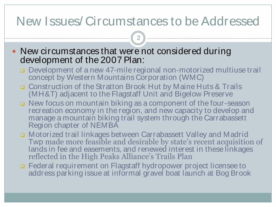
New Issues/Circumstances to be Addressed 2
New circumstances that were not considered during development of the 2007 Plan: Development of a new 47-mile regional non-motorized multiuse trail
concept by Western Mountains Corporation (WMC) Construction of the Stratton Brook Hut by Maine Huts & Trails
(MH&T) adjacent to the Flagstaff Unit and Bigelow Preserve New focus on mountain biking as a component of the four-season
recreation economy in the region, and new capacity to develop and manage a mountain biking trail system through the Carrabassett Region chapter of NEMBA
Motorized trail linkages between Carrabassett Valley and Madrid Twp made more feasible and desirable by state’s recent acquisition of lands in fee and easements, and renewed interest in these linkages reflected in the High Peaks Alliance’s Trails Plan
Federal requirement on Flagstaff hydropower project licensee to address parking issue at informal gravel boat launch at Bog Brook
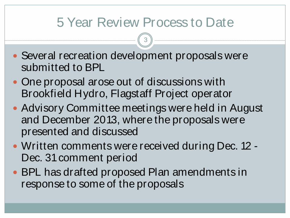
5 Year Review Process to Date 3
Several recreation development proposals were submitted to BPL
One proposal arose out of discussions with Brookfield Hydro, Flagstaff Project operator
Advisory Committee meetings were held in August and December 2013, where the proposals were presented and discussed
Written comments were received during Dec. 12 - Dec. 31 comment period
BPL has drafted proposed Plan amendments in response to some of the proposals
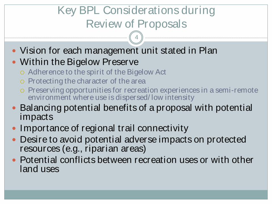
Key BPL Considerations during Review of Proposals
4
Vision for each management unit stated in Plan Within the Bigelow Preserve
Adherence to the spirit of the Bigelow Act Protecting the character of the area Preserving opportunities for recreation experiences in a semi-remote
environment where use is dispersed/low intensity
Balancing potential benefits of a proposal with potential impacts
Importance of regional trail connectivity Desire to avoid potential adverse impacts on protected
resources (e.g., riparian areas) Potential conflicts between recreation uses or with other
land uses
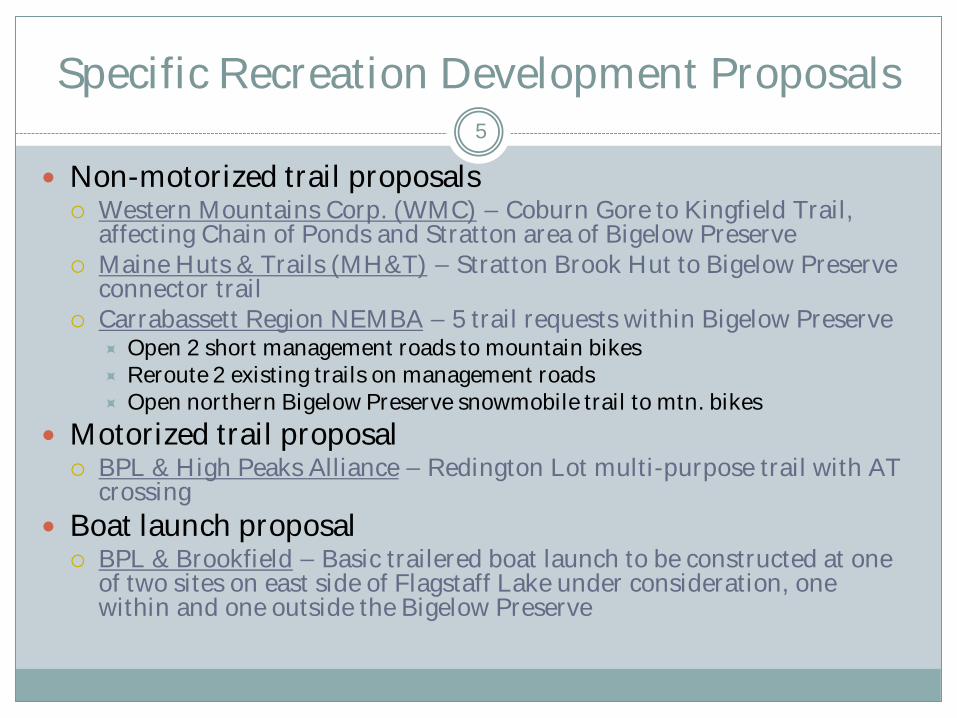
Specific Recreation Development Proposals 5
Non-motorized trail proposals Western Mountains Corp. (WMC) – Coburn Gore to Kingfield Trail,
affecting Chain of Ponds and Stratton area of Bigelow Preserve Maine Huts & Trails (MH&T) – Stratton Brook Hut to Bigelow Preserve
connector trail Carrabassett Region NEMBA – 5 trail requests within Bigelow Preserve
Open 2 short management roads to mountain bikes Reroute 2 existing trails on management roads Open northern Bigelow Preserve snowmobile trail to mtn. bikes
Motorized trail proposal BPL & High Peaks Alliance – Redington Lot multi-purpose trail with AT
crossing
Boat launch proposal BPL & Brookfield – Basic trailered boat launch to be constructed at one
of two sites on east side of Flagstaff Lake under consideration, one within and one outside the Bigelow Preserve
Outline for Presentation of Each Proposal 6
Proposal (concept as described by proponent)
Resource Allocations in affected area
Concerns and constraints considered during review of concept
Justifications for approval of concept (may apply only to concept as modified by BPL)
Proposed Plan amendments
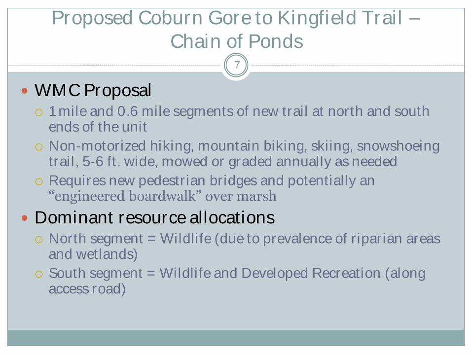
Proposed Coburn Gore to Kingfield Trail – Chain of Ponds
WMC Proposal 1 mile and 0.6 mile segments of new trail at north and south
ends of the unit
Non-motorized hiking, mountain biking, skiing, snowshoeing trail, 5-6 ft. wide, mowed or graded annually as needed
Requires new pedestrian bridges and potentially an “engineered boardwalk” over marsh
Dominant resource allocations North segment = Wildlife (due to prevalence of riparian areas
and wetlands)
South segment = Wildlife and Developed Recreation (along access road)
7
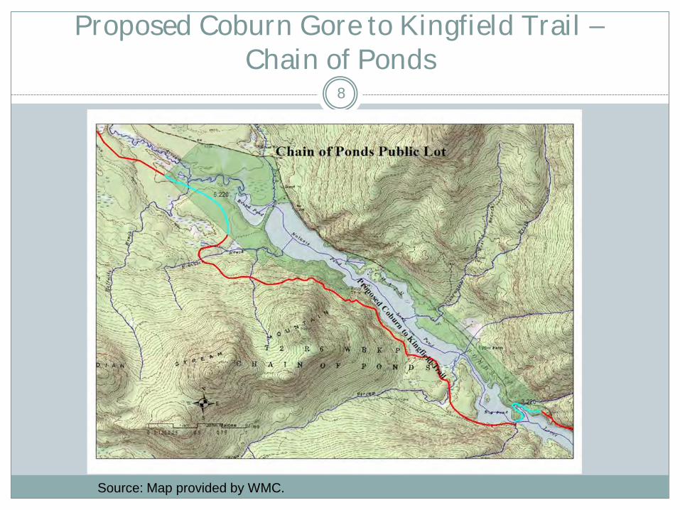
Proposed Coburn Gore to Kingfield Trail – Chain of Ponds
Source: Map provided by WMC.
8
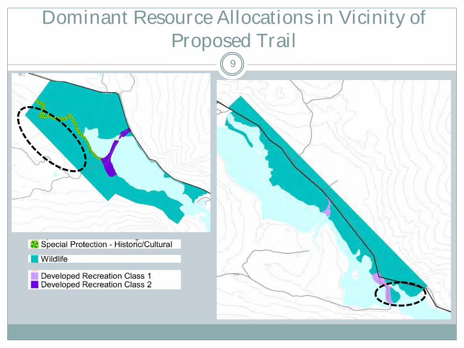
Dominant Resource Allocations in Vicinity of Proposed Trail
9
Proposed Coburn Gore to Kingfield Trail – Chain of Ponds
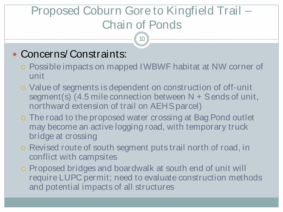
10
Concerns/Constraints: Possible impacts on mapped IWBWF habitat at NW corner of
unit
Value of segments is dependent on construction of off-unit segment(s) (4.5 mile connection between N + S ends of unit, northward extension of trail on AEHS parcel)
The road to the proposed water crossing at Bag Pond outlet may become an active logging road, with temporary truck bridge at crossing
Revised route of south segment puts trail north of road, in conflict with campsites
Proposed bridges and boardwalk at south end of unit will require LUPC permit; need to evaluate construction methods and potential impacts of all structures

Field Photos – Chain of Ponds 11
Landscape west of unit to be crossed by proposed trail
Proposed site of trail crossing between Bag Pond and Lower Pond
Proposed Coburn Gore to Kingfield Trail – Chain of Ponds
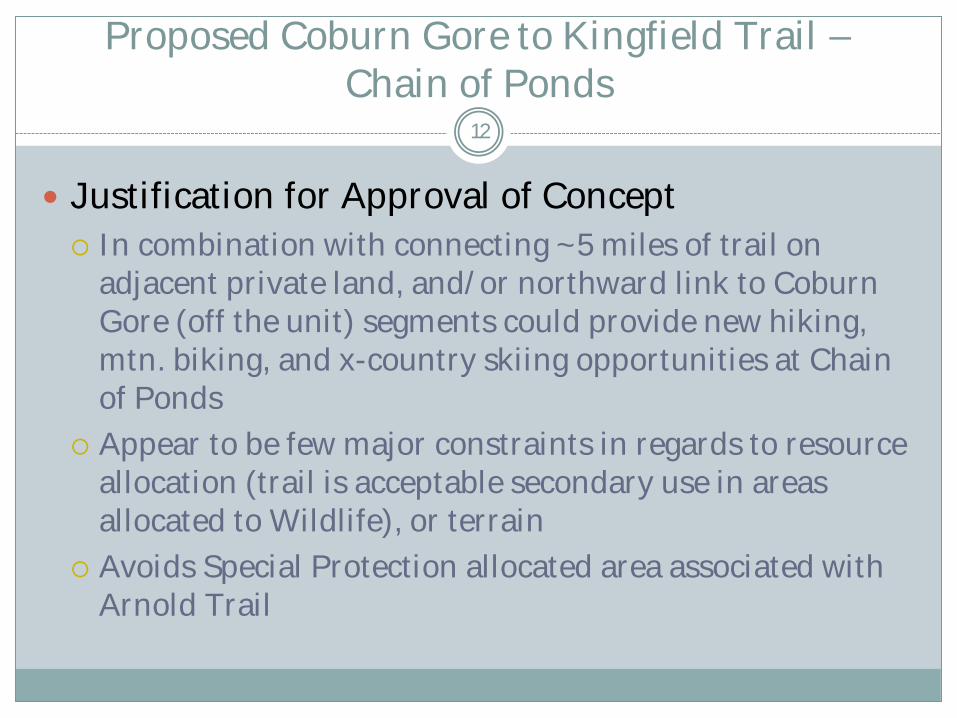
Justification for Approval of Concept
In combination with connecting ~5 miles of trail on adjacent private land, and/or northward link to Coburn Gore (off the unit) segments could provide new hiking, mtn. biking, and x-country skiing opportunities at Chain of Ponds
Appear to be few major constraints in regards to resource allocation (trail is acceptable secondary use in areas allocated to Wildlife), or terrain
Avoids Special Protection allocated area associated with Arnold Trail
12
Proposed Coburn Gore to Kingfield Trail – Chain of Ponds: Potential Plan Amendment
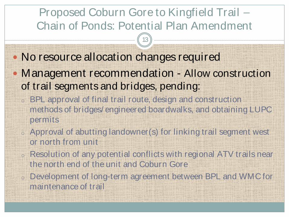
No resource allocation changes required
Management recommendation - Allow construction
of trail segments and bridges, pending: o BPL approval of final trail route, design and construction
methods of bridges/engineered boardwalks, and obtaining LUPC permits
o Approval of abutting landowner(s) for linking trail segment west or north from unit
o Resolution of any potential conflicts with regional ATV trails near the north end of the unit and Coburn Gore
o Development of long-term agreement between BPL and WMC for maintenance of trail
13
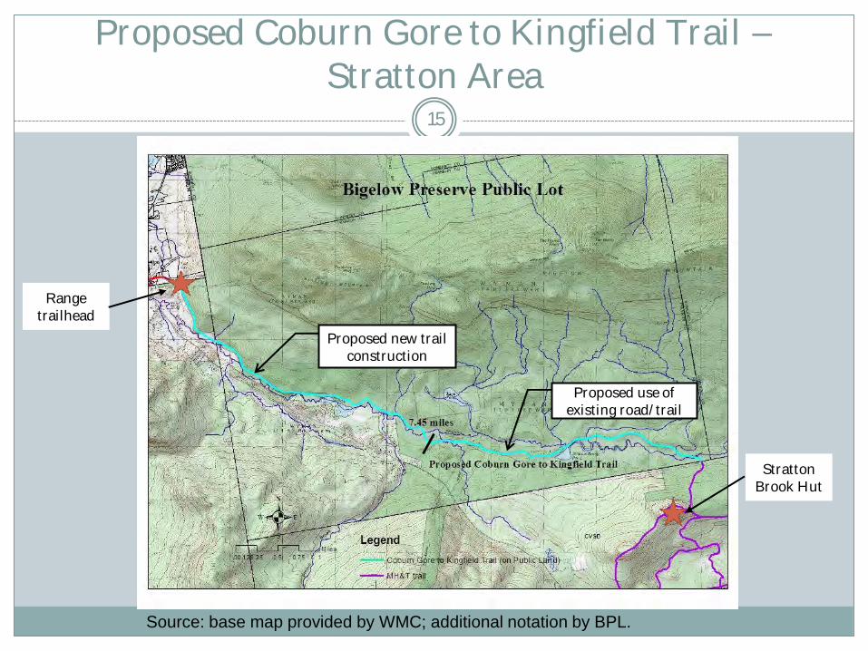
Proposed Coburn Gore to Kingfield Trail – Stratton Area
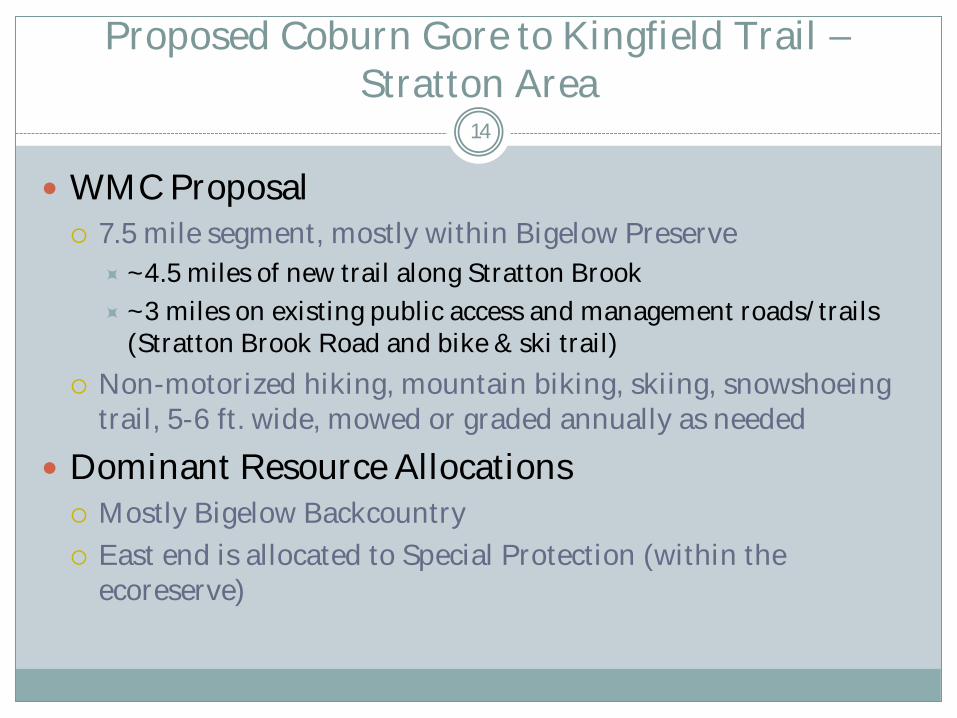
WMC Proposal
7.5 mile segment, mostly within Bigelow Preserve
~4.5 miles of new trail along Stratton Brook
~3 miles on existing public access and management roads/trails (Stratton Brook Road and bike & ski trail)
Non-motorized hiking, mountain biking, skiing, snowshoeing trail, 5-6 ft. wide, mowed or graded annually as needed
Dominant Resource Allocations
Mostly Bigelow Backcountry
East end is allocated to Special Protection (within the ecoreserve)
14
Proposed Coburn Gore to Kingfield Trail – Stratton Area
Proposed new trail construction
Proposed use of existing road/trail
Range trailhead
Stratton Brook Hut
Source: base map provided by WMC; additional notation by BPL.
15

Dominant Resource Allocations in Vicinity of Proposed Trail
16

Propose Coburn Gore to Kingfield Trail – Stratton Area
Concerns/Constraints
A new 5-6 ft. wide multipurpose trail in Preserve, in vicinity of the existing management road and snowmobile trail, raises concern of overdevelopment and cumulative loss of “undeveloped character”
Bigelow Preserve Act does not allow motorized access/motorized vehicles to be used in construction or maintenance of trails in the Preserve.
Potential conflict with proposed MH&T Stratton Brook Hut trail, which this trail would connect to but which would not be open to mountain bikes
17
Proposed Coburn Gore to Kingfield Trail - Stratton Area
18
Justification for Modification and Approval of Concept
West half of trail must follow existing management road/snowmobile trail in order to minimize new infrastructure and impacts to riparian areas
Provides link in new regional non-motorized trail route, with historic/educational focus
No conflict with current resource allocations
East half of proposed trail uses existing trails and roads, which are open to the non-motorized uses proposed

Proposed Coburn Gore to Kingfield Trail – Stratton Area: Potential Plan Amendment
No resource allocation changes required
Management recommendations o Allow trail co-located with existing snowmobile trail on
management road and Stratton Brook Pond Road (already open to mountain bikes), and with existing bike and ski trail on Stratton Brook Pond Road and 60s Road
o Trail must be maintained with non-motorized equipment
o BPL will consider trail improvements to facilitate bike and pedestrian use; any improvements must be compatible with snowmobile use
o Trail concept to be coordinated with other trail proposals to avoid incompatibilities (MH&T Stratton Brook Hut connector trail, CR NEMBA proposed mtn. bike usage of management roads)
19
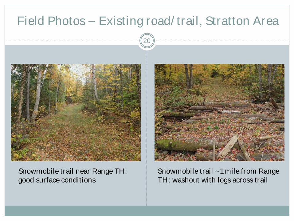
Field Photos – Existing road/trail, Stratton Area
Snowmobile trail near Range TH: good surface conditions
Snowmobile trail ~1 mile from Range TH: washout with logs across trail
20

Recommended Routing of Bike Use on Proposed Stratton Brook Trail Segment
Source: base map provided by WMC; additional notation by BPL.
Appropriate signage
prohibiting bike use on Stratton Brook Hut trail
Appropriate signage directing CG-K trail bike
use south
21
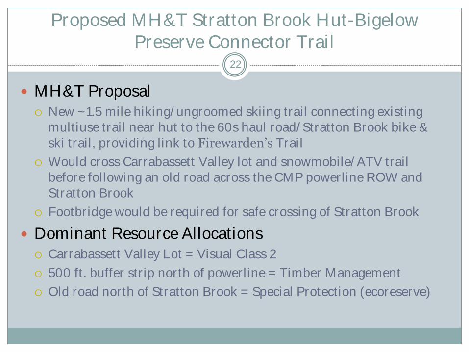
Proposed MH&T Stratton Brook Hut-Bigelow Preserve Connector Trail
MH&T Proposal New ~1.5 mile hiking/ungroomed skiing trail connecting existing
multiuse trail near hut to the 60s haul road/Stratton Brook bike & ski trail, providing link to Firewarden’s Trail
Would cross Carrabassett Valley lot and snowmobile/ATV trail before following an old road across the CMP powerline ROW and Stratton Brook
Footbridge would be required for safe crossing of Stratton Brook
Dominant Resource Allocations Carrabassett Valley Lot = Visual Class 2
500 ft. buffer strip north of powerline = Timber Management
Old road north of Stratton Brook = Special Protection (ecoreserve)
22
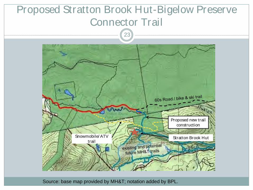
Proposed Stratton Brook Hut-Bigelow Preserve Connector Trail
Stratton Brook Hut
Proposed new trail construction
Snowmobile/ATV trail
Source: base map provided by MH&T; notation added by BPL.
23

Dominant Resource Allocations in Vicinity of Proposed Trail
24

Field Photos – MH&T proposed route
Site of former road crossing of Stratton Brook (note beaver dam)
Old road south of Stratton Brook, with small stream flowing in road bed
25

Proposed Stratton Brook Hut-Bigelow Preserve Connector Trail
Concerns/Constraints
Old road between powerline corridor and Stratton Brook requires work to address drainage problem (water flowing in road)
Bigelow Preserve Act does not allow mechanical equipment to be used in construction of bridge in Bigelow Preserve (applies only to work conducted on north side of brook)
Would reduce acreage on Carrabassett Valley lot available for timber management
Bike riders on 60’s Road may be tempted to turn on to new trail, although it would not be open to or designed for bike use
26
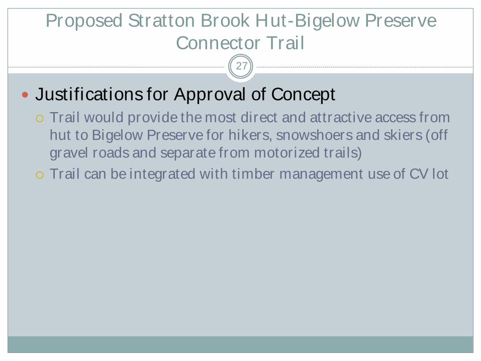
Proposed Stratton Brook Hut-Bigelow Preserve Connector Trail
Justifications for Approval of Concept
Trail would provide the most direct and attractive access from hut to Bigelow Preserve for hikers, snowshoers and skiers (off gravel roads and separate from motorized trails)
Trail can be integrated with timber management use of CV lot
27
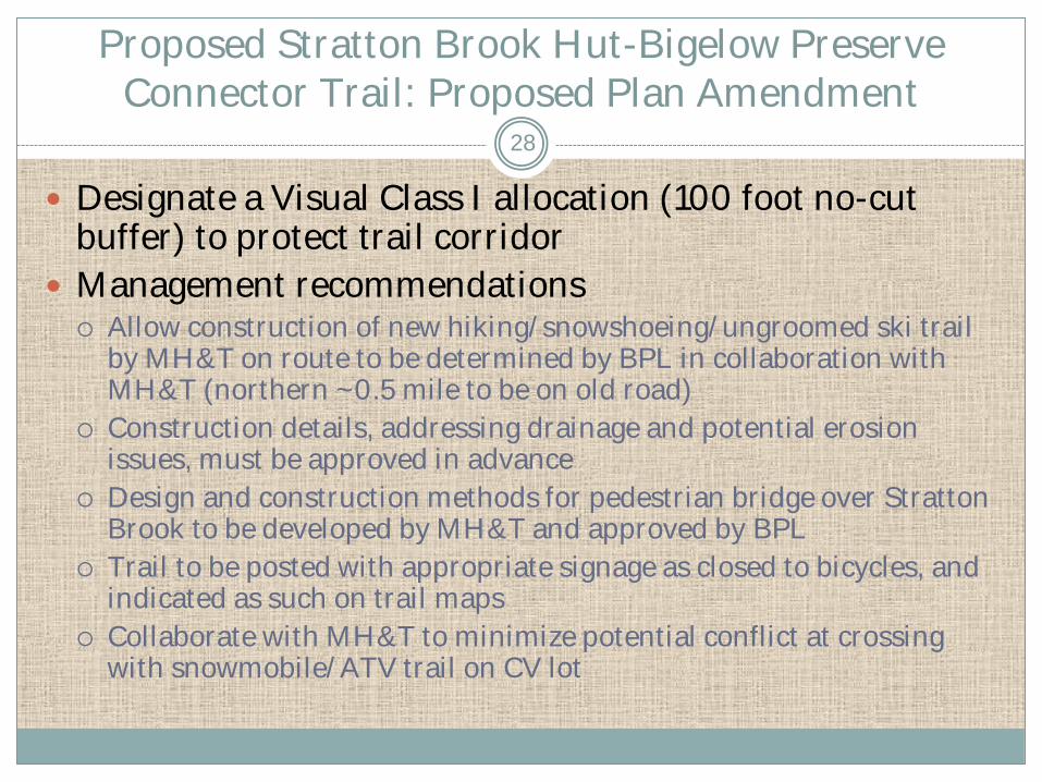
Proposed Stratton Brook Hut-Bigelow Preserve Connector Trail: Proposed Plan Amendment
Designate a Visual Class I allocation (100 foot no-cut buffer) to protect trail corridor
Management recommendations Allow construction of new hiking/snowshoeing/ungroomed ski trail
by MH&T on route to be determined by BPL in collaboration with MH&T (northern ~0.5 mile to be on old road)
Construction details, addressing drainage and potential erosion issues, must be approved in advance
Design and construction methods for pedestrian bridge over Stratton Brook to be developed by MH&T and approved by BPL
Trail to be posted with appropriate signage as closed to bicycles, and indicated as such on trail maps
Collaborate with MH&T to minimize potential conflict at crossing with snowmobile/ATV trail on CV lot
28

CR NEMBA Proposed “Dead Moose Trail”
CR NEMBA Proposal
Allow bike use on 0.7 mile management road/snowmobile trail between Stratton Brook Road parking area and Bigelow Preserve south boundary
Purpose: “connect Esker Trail to town of CV creating loop option connector” [road connects to existing and planned trails on abutting CV Sanitary District land that lead to Stratton Brook Hut and Narrow Gauge Pathway]
Dominant Resource Allocations
Bigelow Backcountry
Timber Management (500 ft. buffer strip)
29
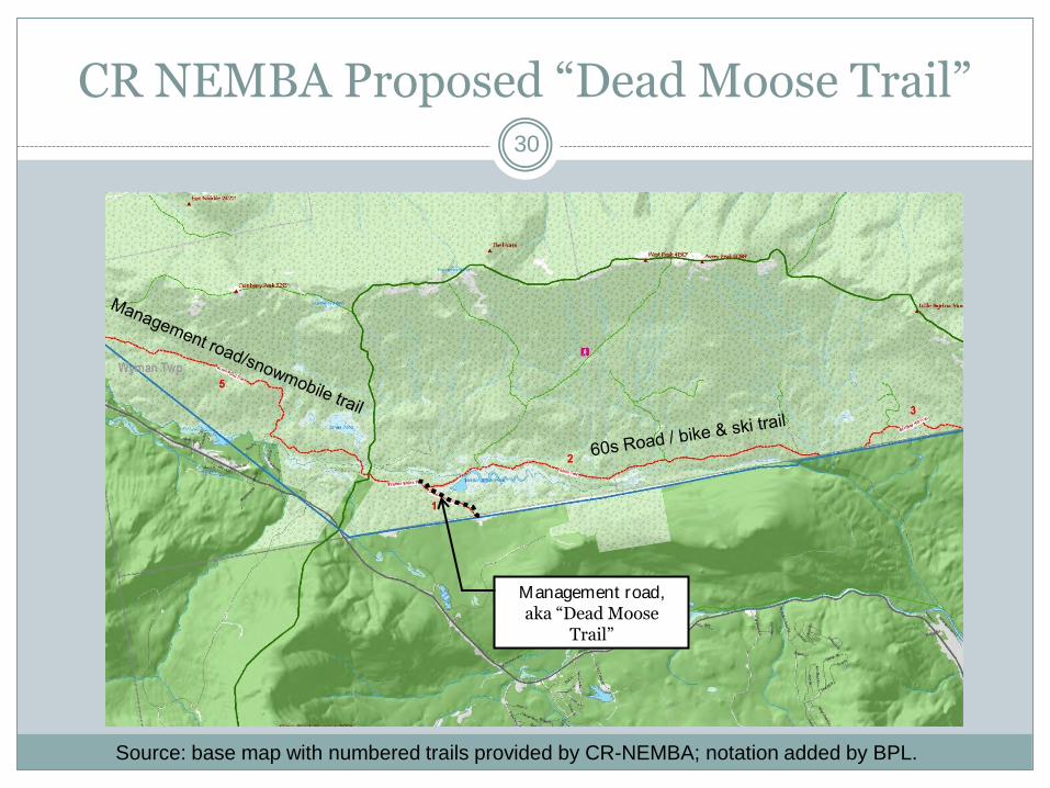
CR NEMBA Proposed “Dead Moose Trail”
Management road, aka “Dead Moose
Trail”
Source: base map with numbered trails provided by CR-NEMBA; notation added by BPL.
30
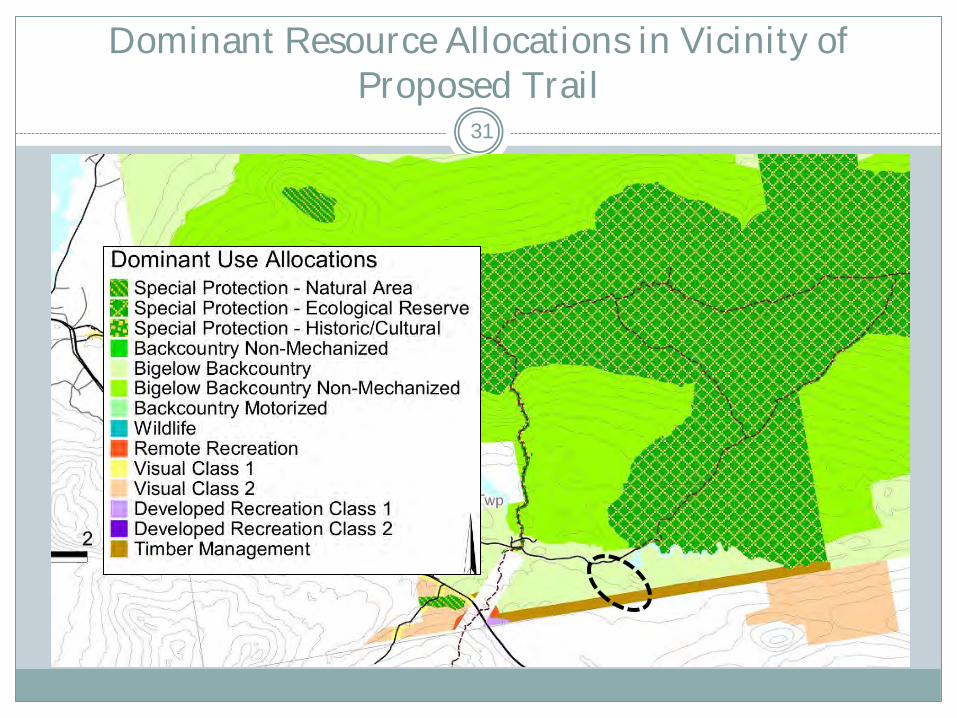
Dominant Resource Allocations in Vicinity of Proposed Trail
31

Field Photos – Proposed “Dead Moose Trail”
North end of road/trail at parking area Washed out culvert on road/trail.
32

CR NEMBA Proposed “Dead Moose Trail”
Concerns/Constraints
Some work on problem areas (e.g., washed out culvert) may be needed before bike use could be authorized
New designated recreation trails may conflict with timber management activities
33
CR NEMBA Proposed “Dead Moose Trail”
Justification for Approval of Concept
No new ground disturbance (existing management road is used informally by mountain bikes)
Provides connection to developing bike touring network (including skidder trails and gravel roads) on abutting Carrabassett Valley Sanitary District lands
Provides loop trail option for riders on existing approved bike routes on Flagstaff Unit/Bigelow Preserve (e.g., 60s Road\Esker Trail)
34
Proposed “Dead Moose Trail” : Proposed Plan Amendment
Add management road to designated roads on which bike use will be permitted (page 126 of Plan)
Consistent with current policy on mountain bike use within the Bigelow Preserve, road will not be formally designated as a “bike trail”
BPL is likely to use the road as a haul route during future timber harvests, and log yards could be constructed along the road
Examine road for potential culvert\drainage repairs to facilitate bike use; schedule any needed repairs as resources allow
35
CR NEMBA Proposed “Birthday Hill Trail”
CR NEMBA Proposal
Allow bike use on 1.5 mile management road/snowmobile trial segment along south Bigelow Preserve boundary
Purpose: “connector trail in existing network, challenging climb/descent”
Dominant Resource Allocation
Bigelow Backcountry
36
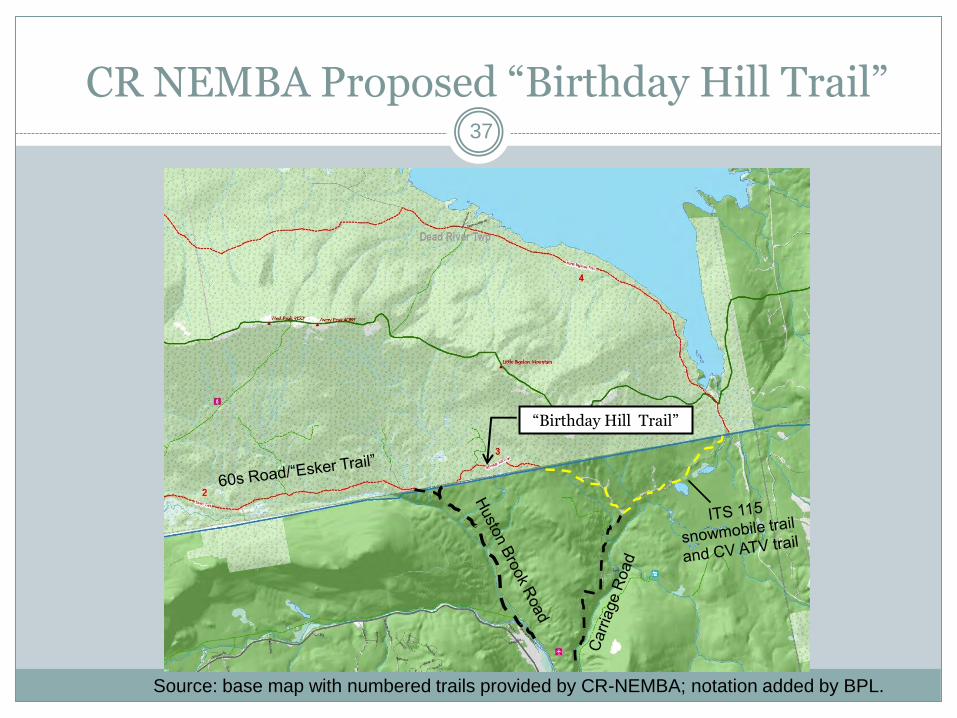
CR NEMBA Proposed “Birthday Hill Trail”
“Birthday Hill Trail”
Source: base map with numbered trails provided by CR-NEMBA; notation added by BPL.
37
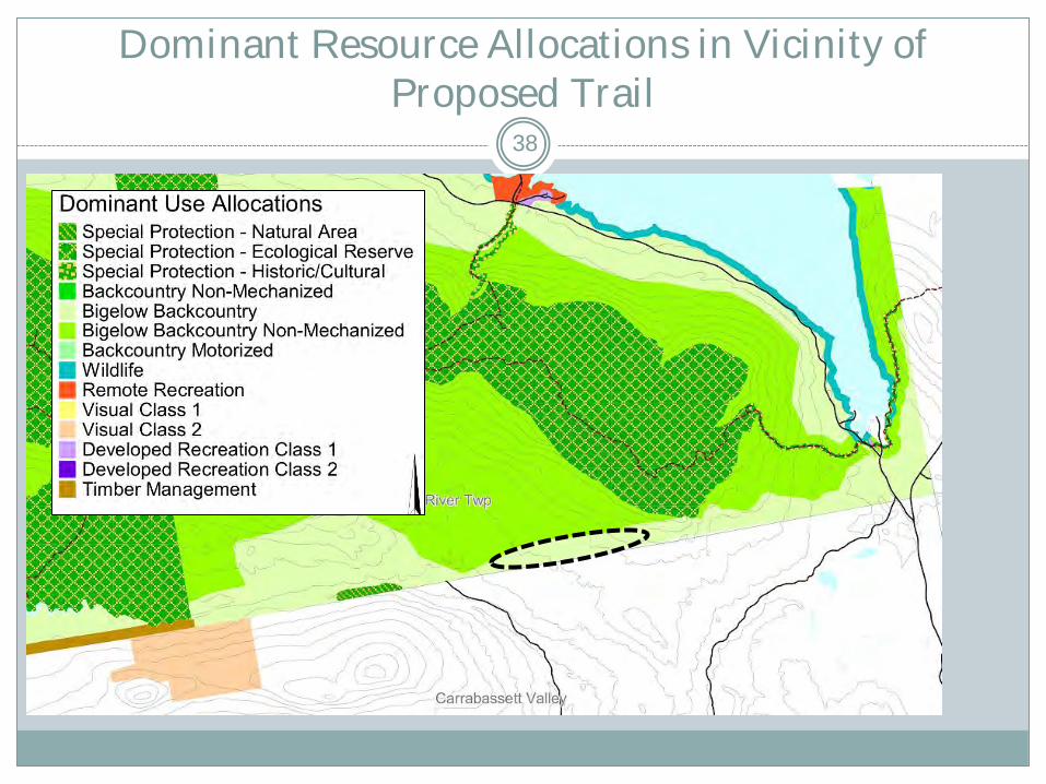
Dominant Resource Allocations in Vicinity of Proposed Trail
38

Field Photos – “Birthday Hill Trail”
Slope on Birthday Hill Trail Level section of Birthday Hill Trail
39
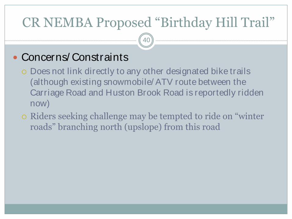
CR NEMBA Proposed “Birthday Hill Trail”
Concerns/Constraints
Does not link directly to any other designated bike trails (although existing snowmobile/ATV route between the Carriage Road and Huston Brook Road is reportedly ridden now)
Riders seeking challenge may be tempted to ride on “winter roads” branching north (upslope) from this road
40

CR NEMBA Proposed “Birthday Hill Trail”
Justifications for Approval of Concept
No new ground disturbance (existing management road used informally by bike riders)
Road links directly to snowmobile/ATV routes on adjacent lands that are used by mountain bike riders
Road links indirectly to the 60s Road/Esker Trail and regional bike trail network via Huston Brook Road and the Carriage Road
Provides gradual climb (most other bike trails and management roads open to bikes in Preserve are generally flat) for riders seeking more physical challenge
41
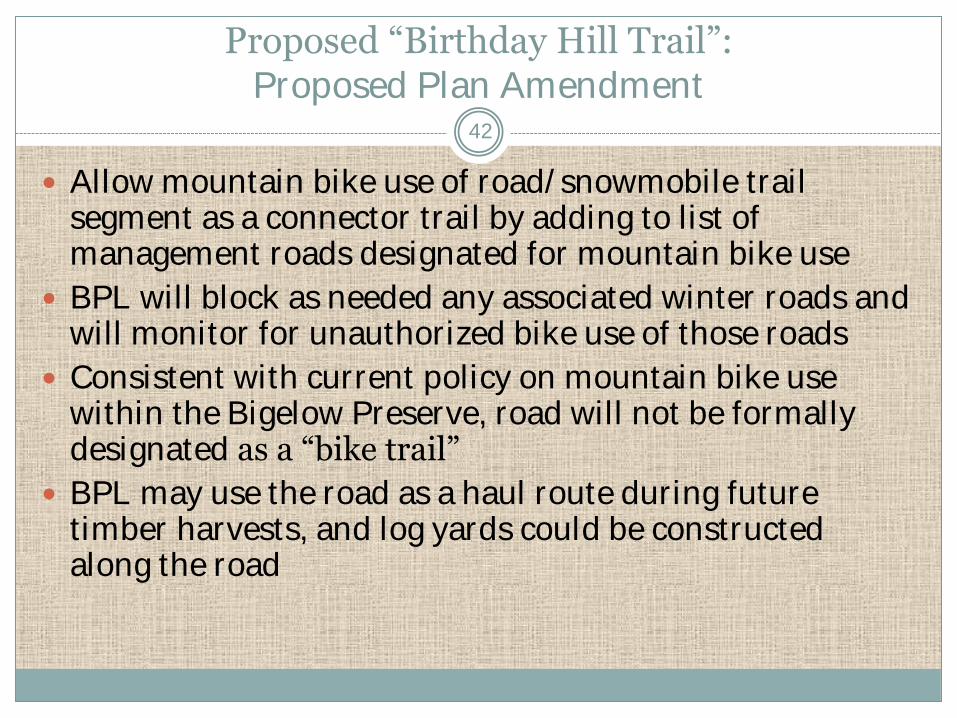
Proposed “Birthday Hill Trail”: Proposed Plan Amendment
Allow mountain bike use of road/snowmobile trail segment as a connector trail by adding to list of management roads designated for mountain bike use
BPL will block as needed any associated winter roads and will monitor for unauthorized bike use of those roads
Consistent with current policy on mountain bike use within the Bigelow Preserve, road will not be formally designated as a “bike trail”
BPL may use the road as a haul route during future timber harvests, and log yards could be constructed along the road
42
CR NEMBA Proposed “Esker Trail” Reroute
CR NEMBA Proposal
Reroute existing trail [~2.4 mile section of the “Esker Trail” within Dead River Twp.] to mitigate for planned use of the road as a haul route during the next few years
Purpose: “Trail to provide wilderness experience for users”
Dominant Resource Allocation
Bigelow Backcountry
43
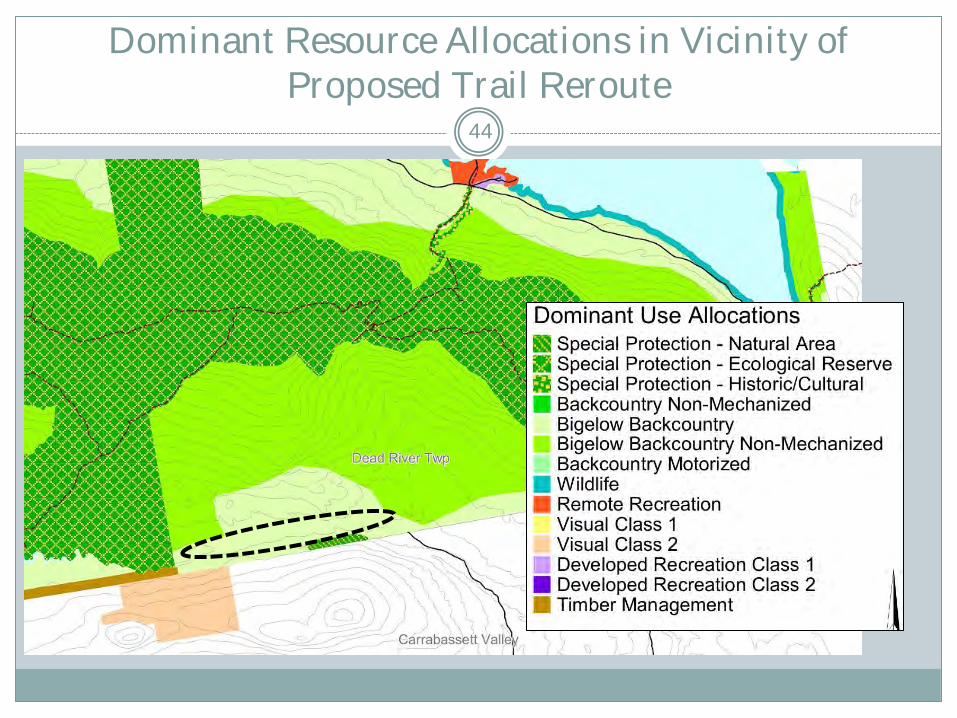
Dominant Resource Allocations in Vicinity of Proposed Trail Reroute
44
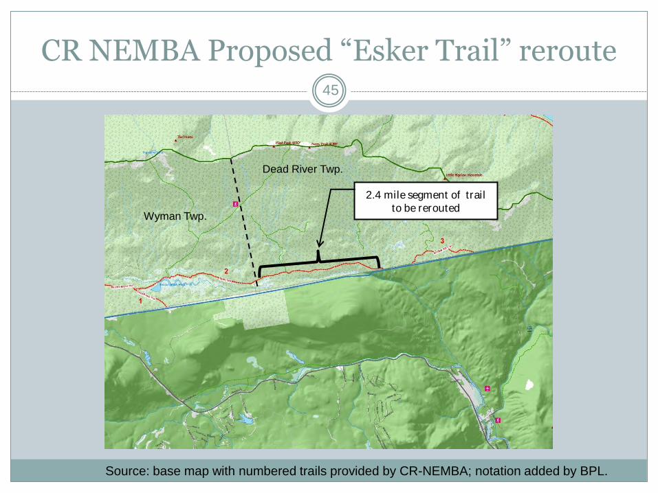
CR NEMBA Proposed “Esker Trail” reroute
2.4 mile segment of trail to be rerouted
Dead River Twp.
Wyman Twp.
Source: base map with numbered trails provided by CR-NEMBA; notation added by BPL.
45
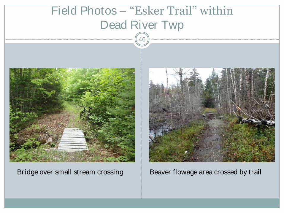
Field Photos – “Esker Trail” within Dead River Twp
Bridge over small stream crossing Beaver flowage area crossed by trail
46

CR NEMBA Proposed “Esker Trail” Reroute
Concerns/Constraints
Rerouted trail would represent new recreational development and require new ground disturbance in Bigelow Preserve
Construction of single-track trail may be perceived as setting a precedent for bike trails in the Bigelow Preserve on other than existing public use and management roads
Availability of resources to construct rerouted trail ahead of planned harvests
Necessity to avoid potential impacts to Huston Brook Pond and its buffer zone (allocated Special Protection)
47
CR NEMBA Proposed “Esker Trail” Reroute
Justification for Approval of Concept Trail is key East-West mtn. bike route in south part of Bigelow
Preserve, linking Huston Brook Road and Stratton Brook Road
Timber harvesting activity will close bike route for 2 seasons, possibly beginning in 2016
Upgrade of road for planned harvest would substantially change the riding experience when the trail is reopened
Would no longer approximate single track riding
Would become similar to riding on other management roads in the Preserve, with a wide cleared ROW and graveled surface
Concept replaces rather than creates an additional route for mountain bikes
Concept does not open up a new area of the Preserve to bike riding
Single-track trail can be constructed sustainably and with minimal ground disturbance
48
Proposed “Esker Trail” Reroute: Proposed Plan Amendment
Collaborate with CR NEMBA on specific route and design for ~2.4 miles of rerouted trail, with intention of providing a “single track” trail
Trail will cross only areas allocated Bigelow Backcountry and will avoid the Special Protection zone around Huston Brook Pond
Trail to be constructed by CR NEMBA
If beaver flowage half mile east of township/county line is not avoided by reroute, consider improving crossing to facilitate trail use during occasional flooding
49

CR NEMBA Proposed Reroute of “Jones Pond Trail”
CR NEMBA Proposal
Allow bike use on 5 miles of management road/snowmobile trail crossing SW Bigelow Preserve (Range TH to Stratton Brook Pond Road)
Reroute existing trail to provide better experience
Purpose: “provide longer loop option for advanced rider /secondary out and back for intermediate rider”
Dominant Resource Allocation
Bigelow Backcountry
50
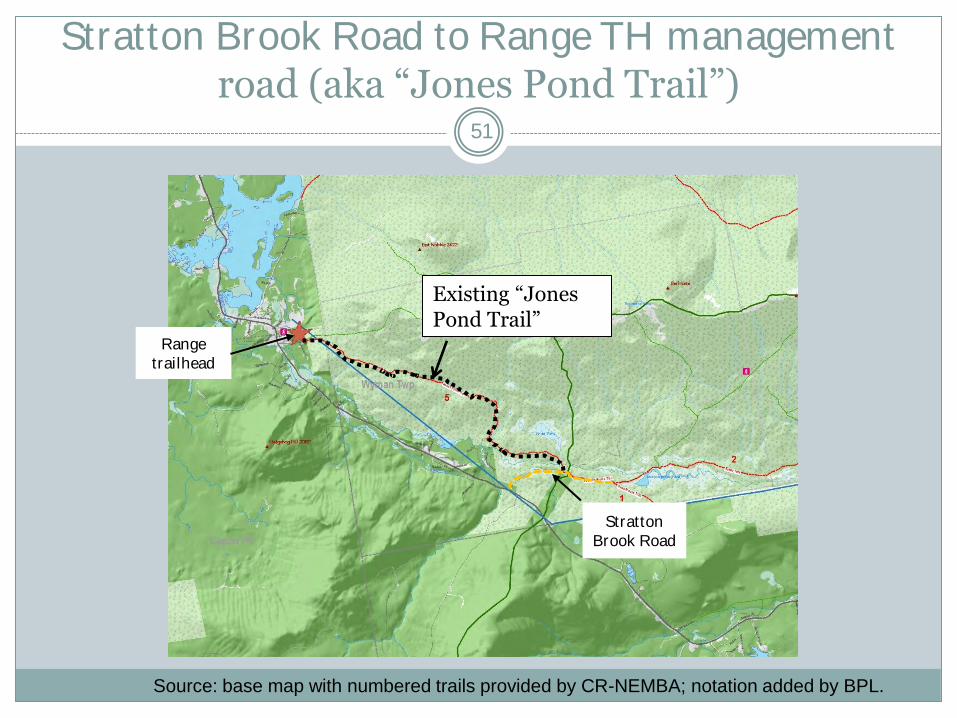
Stratton Brook Road to Range TH management road (aka “Jones Pond Trail”)
Range trailhead
Stratton Brook Road
Source: base map with numbered trails provided by CR-NEMBA; notation added by BPL.
51
Existing “Jones Pond Trail”

Dominant Resource Allocations in Vicinity of Proposed Trail Reroute
52
CR NEMBA Proposed “Jones Pond Trail” Reroute
Concerns/Constraints
Wet areas within westernmost mile of currently designated trail (“winter road” section) are not in desired condition for bike use
Entirely rerouted trail to provide alternative to management road riding would entail 5 miles of new trail in Bigelow Preserve, raising concern about overdevelopment in “Bigelow Backcountry” and preservation of “overall natural character” of the Preserve
53

CR NEMBA Proposed “Jones Pond Trail” Reroute
Justification for Approval of Concept
Road has already been designated for mountain bike use (page 126 of Plan)
Eastern 4 miles of trail is “surfaced summer road” in good condition for bike use
Provides bike route connecting Carrabassett Valley to Stratton community
54
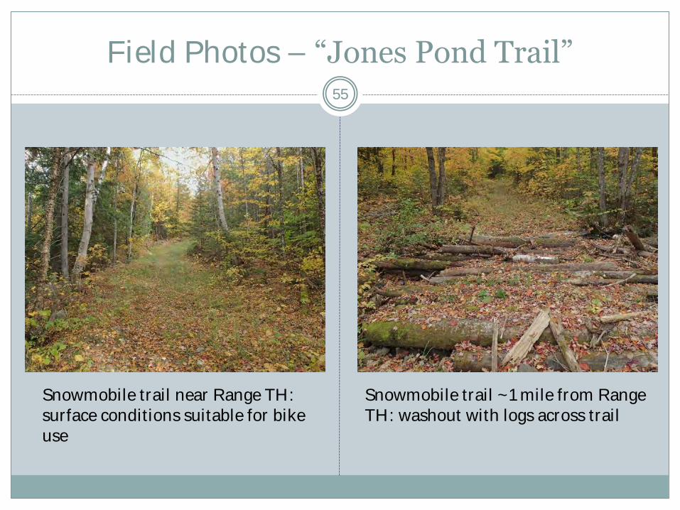
Field Photos – “Jones Pond Trail”
Snowmobile trail near Range TH: surface conditions suitable for bike use
Snowmobile trail ~1 mile from Range TH: washout with logs across trail
55
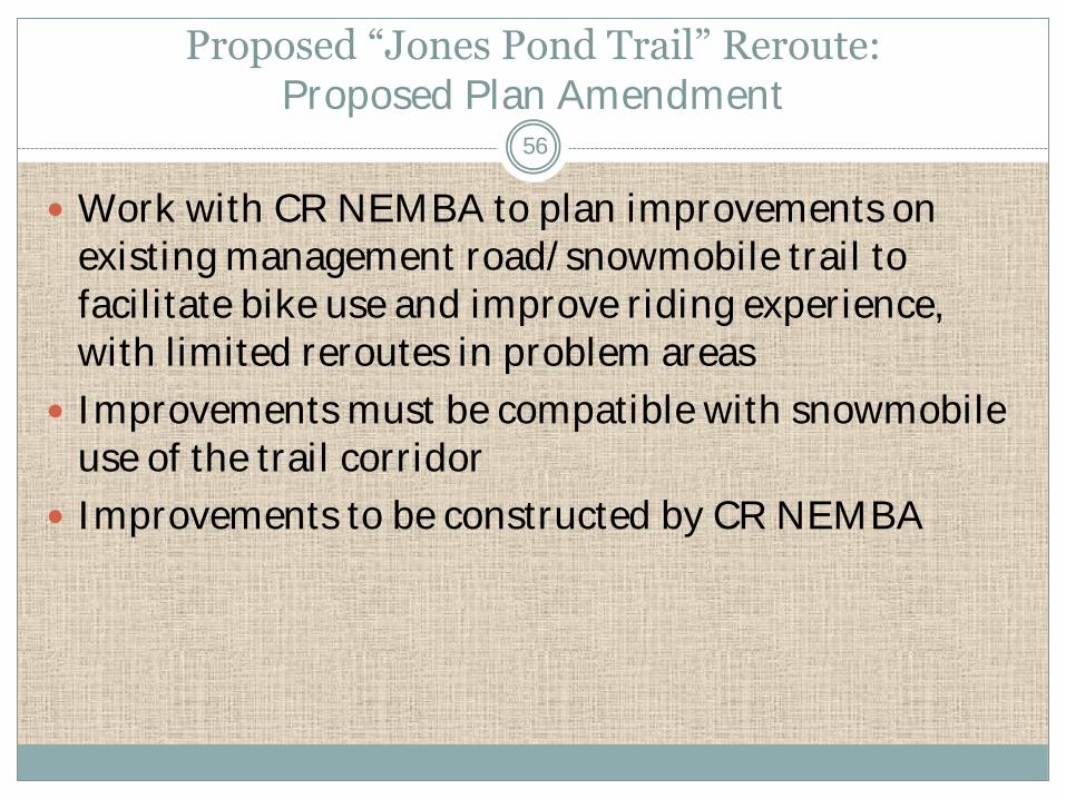
Proposed “Jones Pond Trail” Reroute: Proposed Plan Amendment
Work with CR NEMBA to plan improvements on existing management road/snowmobile trail to facilitate bike use and improve riding experience, with limited reroutes in problem areas
Improvements must be compatible with snowmobile use of the trail corridor
Improvements to be constructed by CR NEMBA
56

CR NEMBA Proposed “Backside Trail”
Existing snowmobile trail & proposed bike
trail route
Source: base map with numbered trails provided by CR-NEMBA; notation added by BPL.
57

Dominant Resource Allocations in Vicinity of Proposed Trail
58

Field Photos – “Backside Trail”
Wet area with drainage across trail (Bigelow Twp.)
Beaver dam and flowage across trail (Bigelow Twp.)
59
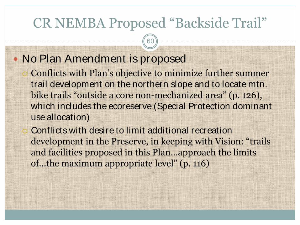
CR NEMBA Proposed “Backside Trail”
No Plan Amendment is proposed
Conflicts with Plan’s objective to minimize further summer trail development on the northern slope and to locate mtn. bike trails “outside a core non-mechanized area” (p. 126), which includes the ecoreserve (Special Protection dominant use allocation)
Conflicts with desire to limit additional recreation development in the Preserve, in keeping with Vision: “trails and facilities proposed in this Plan…approach the limits of...the maximum appropriate level” (p. 116)
60

Proposed Redington Lot AT Crossing
BPL & High Peaks Alliance Proposal
Allow a perpendicular crossing of the AT corridor on the Redington Lot by a new shared motorized/non-motorized recreation trail
Purpose: provide trail link (along with segments on abutter’s lands) between Caribou Valley Road and Madrid Township
Dominant Allocations
Special Protection – 100 ft. buffer on each side of AT
Remote Recreation – additional 400 ft. buffer on each side
Timber Management – remainder of lot
61
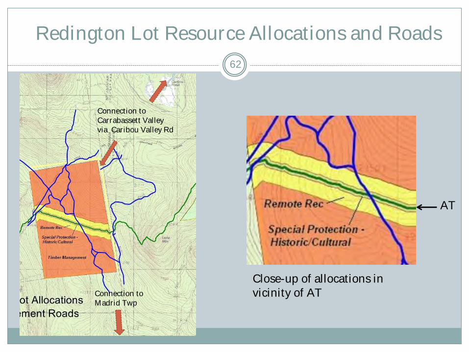
Redington Lot Resource Allocations and Roads
62
Connection to Carrabassett Valley via Caribou Valley Rd
Connection to Madrid Twp
Close-up of allocations in vicinity of AT
AT

Proposed Redington Lot AT Crossing
Concerns/Constraints Current Plan does not allow new motorized recreation trails within 500
feet of the AT (within the Special Prot./Remote Rec. buffer) IRP does not allow new motorized trails in “natural” or
“historic/cultural” Special Protection areas (page 12) IRP requires that adjacent landowner approval be sought and received
before planned trail connections are approved (page 64); Abutters = Sugarloaf Corp to north, Wagner to south
Some organizations and members of local trails community oppose development of motorized trails in core of High Peaks area
Potential for impacts on AT and disturbance of AT hiker’s experience associated with motorized/mechanized activity (e.g., mountain bikes and ATVs during summer)
New trail construction would likely be required on Redington Lot within TM area, where separate motorized (ATV and snowmobile) and “mechanically assisted” (mtn. bike and groomed ski) trails are desired, which may conflict with timber management
63
Proposed Redington Lot AT Crossing
Justification for Approval of Concept
Existing timber management road on lot could provide shared-use trail crossing of AT (avoids a new motorized crossing of AT, although use of crossing would expand from timber management only to recreation)
Provides a regional link for snowmobiles, ATVs, and groomed ski trails to connect the Caribou Valley Road to trails south of the lot on Madrid Twp.
A number of trail interests in the region consider this link to be vital to the development of regional trail networks
No other north-south motorized trail linkage routes in this area appear viable
64
Proposed Redington Lot AT Crossing:
Proposed Plan Amendment*
Dominant Resource allocations Reallocate 100-foot Special Protection buffer to Remote Recreation
in the immediate vicinity of management road crossing of AT
Allow new motorized recreation trail within 500 feet of the AT (within the Remote Recreation buffer); IRP allows if meet 3 criteria
Management Recommendations Collaborate with regional trail organizations (e.g., snowmobile and
ATV clubs, CR-NEMBA, MH&T, MATC) to develop the best trail alignment on BPL and adjoining properties that would utilize a shared AT crossing on existing management road and shared or, potentially, separate motorized and non-motorized trails on and off the lot
Develop plan with AT organizations to control and monitor mountain bike and motorized use at AT crossing to ensure no trespass onto AT and to minimize potential conflicts with hikers
65
* Pending approval from abutters of motorized trail on their parcels
Proposed East Flagstaff Lake Boat Launch
Brookfield Proposal To meet FERC license obligations, Brookfield has proposed to
“investigate potential locations…for alternate trailered boat access” due to lack of viable options for day parking at Bog Brook boat launch
2 options have been discussed: develop basic trailered launch at Little Bigelow Gravel Pit trailhead construct new launch ramp on Dead River Peninsula, in vicinity of
North Flagstaff Road (specific site TBD)
Resource Allocations Gravel Pit site:
Parking and campsites (former gravel pit) = Developed Recreation Class I Shoreline zone (330 ft. buffer) – Dominant = Wildlife, Secondary = Remote
Recreation
Dead River Peninsula site: Shoreline zone (330 ft. buffer) - Dominant=Wildlife, no secondary allocation Outside buffer zone = Timber Management
66
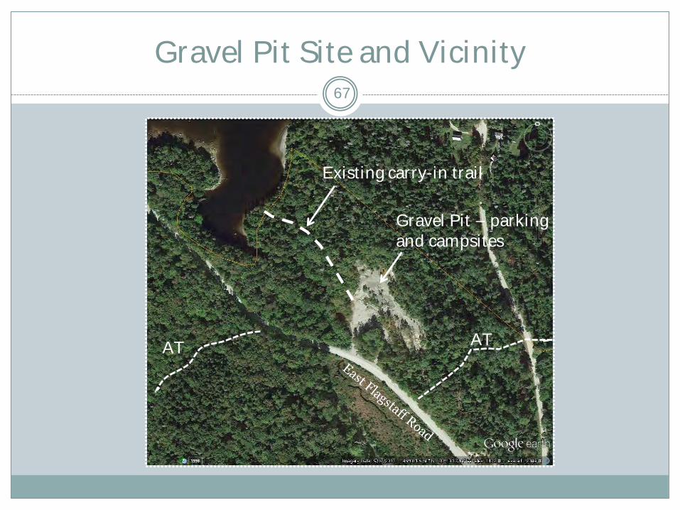
Gravel Pit Site and Vicinity 67
Existing carry-in trail
Gravel Pit – parking and campsites
AT AT
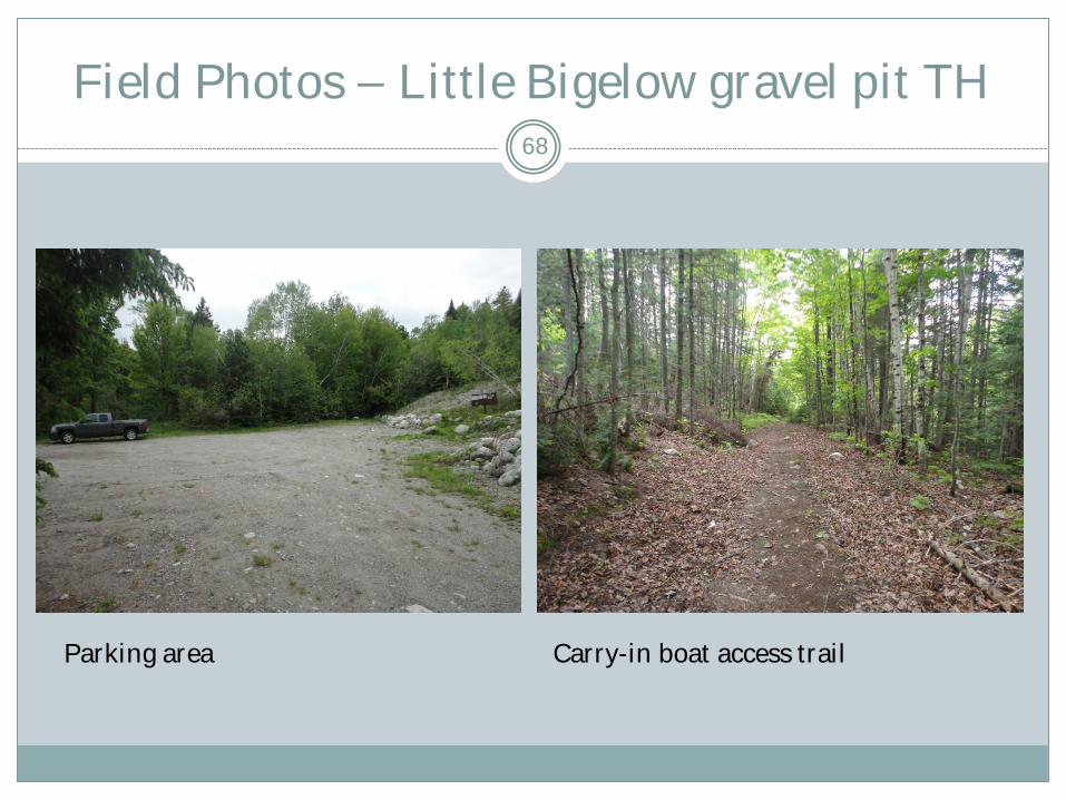
Field Photos – Little Bigelow gravel pit TH 68
Parking area Carry-in boat access trail
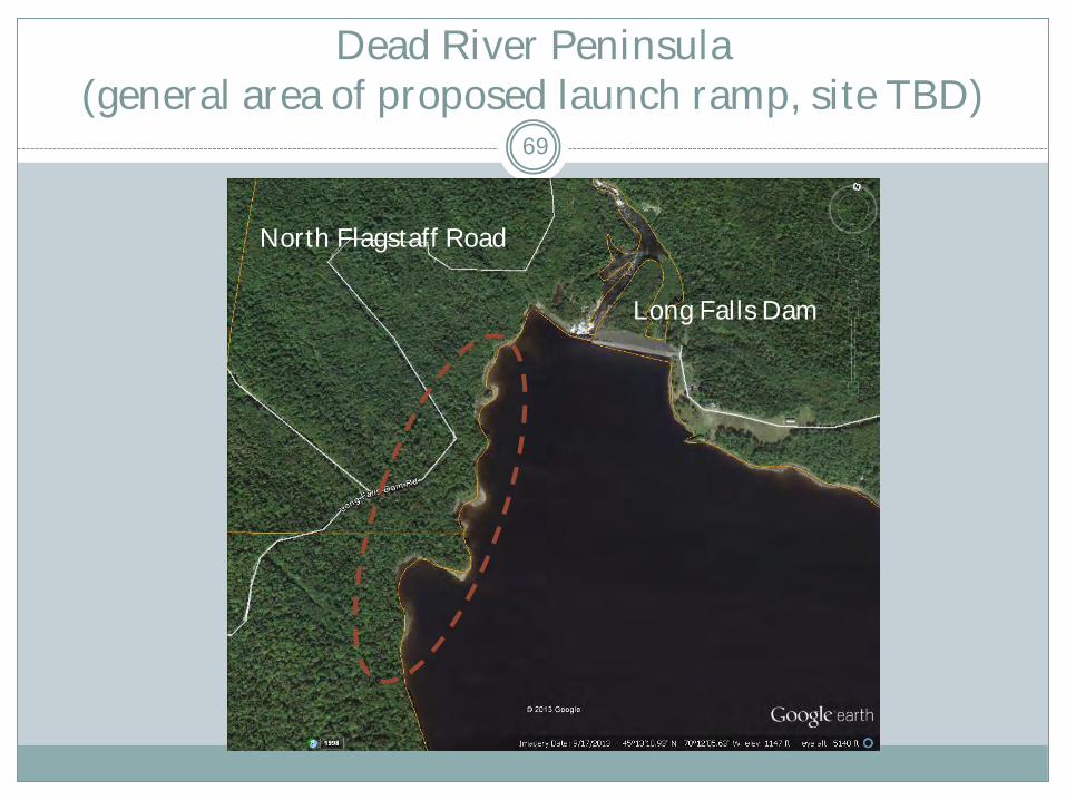
Dead River Peninsula (general area of proposed launch ramp, site TBD)
69
Long Falls Dam
North Flagstaff Road

Dominant Resource Allocations in Vicinity of Proposed Boat Launch – Gravel Pit Site
70

Dominant Resource Allocations in Vicinity of Proposed Boat Launch – Dead River Peninsula Site
71

Proposed East Flagstaff Lake Boat Launch
Concerns/Constraints Gravel Pit site:
Within Bigelow Preserve (some may consider a new boat launch to be incompatible with maintaining “undeveloped character” of Preserve)
Remote Recreation secondary allocation allows only carry-in boat access
Potential conflicts with existing uses (trailhead parking and primitive campsites)
AT routed on road and through woods adjacent to site
Dead River Peninsula site: Development would likely involve more new ground disturbance and
would be more costly than Gravel Pit site Considerable distance (10+ miles) from existing Bog Brook launch
that new launch would replace and less accessible from nearby communities
Remoteness of site may make it more vulnerable to abuse and other management problems
72

Proposed East Flagstaff Lake Boat Launch
Justifications for Approval of Concept
General: No fully functional trailered boat access on east side of lake
The limited capacity and design of the intended facility and the large area and shallow character of the lake would minimize potential impacts on non-motorized boating
Facility would facilitate access by non-motorized as well as motorized boaters, particularly large groups with multiple boats
Gravel Pit site: Close to existing Bog Brook site, easily accessible from communities to south
Most of site already disturbed (new construction would be required for launch ramp and turn-around that would replace existing 400 ft. carry-in foot trail, and expansion of parking area within former gravel pit)
Dead River Peninsula site: outside of Bigelow Preserve
no conflict with existing uses
73
Proposed East Flagstaff Lake Boat Launch: Proposed Plan Amendment
Explore with Brookfield the development of one of two potential new trailered boat launch sites on east Flagstaff Lake
If Gravel Pit site selected: Consistent with 1981 Bigelow Preserve Policy and Guidelines
incorporated into the 2007 Plan (p. 117), allow for development of facility as “a basic facility necessary to provide access”
Expand existing trailhead/campsite parking to provide 4-6 vehicle with trailer parking spaces
Modify existing carry-in trail to a gravel trailered boat ramp with a turnaround, and with a cement plank surface at the lower end
Revise shore zone allocation from Wildlife/Remote Recreation to Developed Recreation Class I in area of launch ramp
Collaborate with Boating Facilities Program and Brookfield on design, permitting, and construction of facility
74
Proposed East Flagstaff Lake Boat Launch: Proposed Plan Amendment
If Dead River Peninsula site selected: Revise Dominant Allocation from Wildlife and Timber Management
(if applicable) to Developed Recreation Class I in area of launch ramp
Construct a new gravel trailered boat launch ramp with parking for 4-6 vehicles and trailers, with access via the North Flagstaff Road
Collaborate with Boating Facilities Program and Brookfield on siting, design, permitting, and construction of facility
Consider site maintenance arrangement using Camp Host volunteer stationed at Big Eddy
75

Summary – Proposals Accepted 76
Plan amendments would allow the following proposals to move forward, with prescribed requirements and changes to concept as indicated:
Non-motorized trail segments at Chain of Ponds
Non-motorized trail segment at Stratton area/Bigelow Preserve, without new trail construction
Mountain bike use of 2 short management roads in Preserve
Minor reroutes of “Jones Pond” bike route in problem areas
Reroute of Dead River Twp. portion of Esker Trail
Connector trail from Stratton Brook Hut to Bigelow Preserve
Basic trailered boat launch on East Flagstaff Lake
Shared motorized/non-motorized crossing of AT on Redington Lot
Summary – Proposals Rejected 77
No Plan amendments have been proposed to allow the following proposals , or portions of proposals 4.5 miles of new non-motorized trail along Stratton Brook
Complete or substantial reroute of “Jones Pond” bike route
Mountain bike crossing of northern portion of Bigelow Preserve
BPL has judged these to be incompatible with the 2007 Plan and/or the BPL Vision for the affected properties, and has proposed amendments to allow alternatives that require little or no new development on public lands


