FLIGHT TESTS OF IFR LANDING APPROACH SYSTEMS FOR HELICOPTERS J. S. Bull, D. M. Hegarty, L. L. Peach, J. D. Phillips, D. J. Anderson, D. C. Dugan, and V. L. Ross Ames Research Center SUMMARY The helicopter section of the U.S. Standard for Terminal Instrument Procedures (TERPS) was first issued in 1970, when only a few civilian heli- copters were IFR certified and operations under Instrument Flight Rules (IFR) were very limited. In the subsequent decade, there has been considerable technological progress in the helicopter industry, and there has been a sig- nificant increase in civilian IFR operations. Thus, there exists a need to update the existing helicopter TERPS criteria in order that civilian opera- tors may take maximum advantage of the helicopter's unique flight capabilities. In response to this need for the establishment of new helicopter TERPS criteria, the Ames Research Center and the FAA Flight Standards National Field Office have conducted two joint flight-test investigations: (1) airborne radar approaches (ARA) and (2) microwave landing system (MLS) approaches. The first flight-test investigation consisted of helicopter IFR approaches to offshore oil rigs in the Gulf of Mexico, using weather/mapping radar, operational pilots, and a Bell 212 helicopter. The second flight-test inves- tigation consisted of IFR MLS approaches at Crows Landing (near Ames Research Center), with a Bell UH-1H helicopter, using NASA, FAA, and operational indus- try pilots. The purposes of the flight tests were to (1) provide the FAA with statistical data for establishment of TERPS criteria and (2) provide NASA with a data base to serve as a performance measure for advanced guidance and navigation concepts. INTRODUCTION In the past decade, there has been increased utilization of the heli- copter for transportation into remote sites as well as into high-traffic- density hub airports. Concurrent with this increased transportation utilization is a significant increase in operation under instrument flight rules (IFR). For example, the growth of the helicopter offshore transporta- tion industry has been stimulated in recent years by the accelerated develop- ment and exploration of the Nation's offshore oil resources (ref. I)= To avoid flight cancellations or delays caused by unfavorable weather conditions, airborne weather/mapping radar has been developed by the operators as a ground-based navigation aids. Operational implementation of the new National Microwave Landing System, which is also under way (ref. 2), will provide an expanded IFR landing approach capability particularly suited to the self-contained" navigation aid for landings on sites where there are no I1 145 https://ntrs.nasa.gov/search.jsp?R=19810010516 2018-07-04T00:42:45+00:00Z
Transcript
FLIGHT TESTS OF IFR LANDING APPROACH SYSTEMS FOR HELICOPTERS
J. S. Bull, D. M. Hegarty, L. L. Peach, J. D. Phillips, D. J. Anderson, D. C. Dugan, and V. L. Ross
Ames Research Center
SUMMARY
The helicopter section of the U.S. Standard for Terminal Instrument Procedures (TERPS) was first issued in 1970, when only a few civilian heli- copters were IFR certified and operations under Instrument Flight Rules (IFR) were very limited. In the subsequent decade, there has been considerable technological progress in the helicopter industry, and there has been a sig- nificant increase in civilian IFR operations. Thus, there exists a need to update the existing helicopter TERPS criteria in order that civilian opera- tors may take maximum advantage of the helicopter's unique flight capabilities.
In response to this need for the establishment of new helicopter TERPS criteria, the Ames Research Center and the FAA Flight Standards National Field Office have conducted two joint flight-test investigations: (1) airborne radar approaches (ARA) and (2) microwave landing system (MLS) approaches. The first flight-test investigation consisted of helicopter IFR approaches to offshore oil rigs in the Gulf of Mexico, using weather/mapping radar, operational pilots, and a Bell 212 helicopter. The second flight-test inves- tigation consisted of IFR MLS approaches at Crows Landing (near Ames Research Center), with a Bell UH-1H helicopter, using NASA, FAA, and operational indus- try pilots. The purposes of the flight tests were to (1) provide the FAA with statistical data for establishment of TERPS criteria and (2) provide NASA with a data base to serve as a performance measure for advanced guidance and navigation concepts.
INTRODUCTION
In the past decade, there has been increased utilization of the heli- copter for transportation into remote sites as well as into high-traffic- density hub airports. Concurrent with this increased transportation utilization is a significant increase in operation under instrument flight rules (IFR). For example, the growth of the helicopter offshore transporta- tion industry has been stimulated in recent years by the accelerated develop- ment and exploration of the Nation's offshore oil resources (ref. I)= To avoid flight cancellations or delays caused by unfavorable weather conditions, airborne weather/mapping radar has been developed by the operators as a
ground-based navigation aids. Operational implementation of the new National Microwave Landing System, which is also under way (ref. 2), will provide an expanded IFR landing approach capability particularly suited to the
self-contained" navigation aid for landings on sites where there are no I 1
h e l i c o p t e r ' s unique f l i g h t c h a r a c t e r i s t i c s . s lope and o f f s e t r a d i a l f e a t u r e s of t he microwave landing system (MLS) w i l l permit g r e a t e r approach-path f l e x i b i l i t y , which can be u t i l i z e d i n no i se abatement, minimum airspace, and t r a f f i c s e p a r a t i o n procedures f o r high- d e n s i t y hub a i r p o r t ope ra t ions .
The a i rbo rne s e l e c t a b l e g l i d e
The cu r ren t e d i t i o n of t he U.S. Standard f o r Terminal Instrument Proce- du res (TERPS) ( r e f . 3 ) con ta ins no c r i t e r i a r e l a t i v e t o h e l i c o p t e r instrument approaches t h a t u t i l i z e e i t h e r a i rbo rne r ada r o r MLS as t h e primary naviga- t i o n source. Operators are c u r r e n t l y us ing a i rbo rne r ada r approach ( A M ) procedures t h a t have been approved by t h e FAA on a r eg iona l b a s i s ; however, t hese procedures have no t been approved as a n a t i o n a l s tandard , as would be se t by TERPS. I n add i t ion , s i n c e p rec i s ion MLS instrument approaches w i l l o f f e r many advantages t o h e l i c o p t e r ope ra to r s over t h e convent ional i n s t r u - ment landing system (ILS) approach, t h e r e is a need t o update e x i s t i n g h e l i - cop te r TERPS c r i te r ia i n o rde r t h a t c i v i l i a n ope ra to r s may t ake maximum advantage of ARA and MLS instrument approach procedures.
I n response t o t h i s need, Ames Research Center and t h e FAA F l i g h t Standards Nat ional F i e l d Of f i ce have conducted two j o i n t f l i g h t - t e s t i n v e s t i - ga t ions : (1) a i rbo rne r ada r approaches (ARA) ( r e f s . 4 , 5, 6) and (2) micro- wave landing system (MLS) approaches ( r e f . 7 ) . The f i r s t f l i g h t - t e s t i n v e s t i g a t i o n cons i s t ed of h e l i c o p t e r IFR approaches t o o f f shore o i l r i g s i n t h e Gulf of Mexico, us ing weather/mapping r a d a r , ope ra t iona l p i l o t s , and a B e l l 212 h e l i c o p t e r . The second f l i g h t - t e s t i n v e s t i g a t i o n cons is ted of IFR MLS approaches a t Crows Landing (near A m e s Research Center ) , wi th a B e l l UH-1H h e l i c o p t e r flown by NASA, FAA, and o p e r a t i o n a l i ndus t ry p i l o t s . The purposes of t he f l i g h t tests w e r e t o (1) provide the FAA wi th s t a t i s t i ca l d a t a f o r es tabl ishment of TERPS c r i t e r i a and (2) provide NASA wi th a data base t o se rve as a performance measure f o r development of advanced guidance and naviga t ion concepts . The s p e c i f i c f l i g h t tes t o b j e c t i v e s were t o :
1. Develop procedures 2. Measure t o t a l system e r r o r s 3 . Measure naviga t ion equipment e r r o r s 4 . Measure f l i g h t t e c h n i c a l e r r o r s 5 . Determine acceptab le weather minimums
This paper p re sen t s t h e r e s u l t s of t hese two J o i n t NASA/FAA h e l i c o p t e r f l i g h t tests.
TEST DESCRIPTION
General T e s t Plan
The gene ra l p l an f o r conducting both f l i g h t tests w a s t o (1) inc lude ope ra t iona l p i l o t s i n the tests, (2) conduct approaches "under the hood" f o r IFR s imula t ion , ( 3 ) conduct bo th landings and missed approaches, and ( 4 ) con- duc t a s u f f i c i e n t number of approaches t o a l low f o r s t a t i s t i c a l a n a l y s i s of f l i g h t envelopes.
146
Airborne Radar Approach (a) T e s t Descr ip t ion
F l i g h t tests of h e l i c o p t e r a i rbo rne r ada r approaches were conducted using a B e l l 212 h e l i c o p t e r ( f i g . 1); a c l u s t e r of seven o i l p la t forms , l oca t ed about 15 m i l e s sou th of I n t r a c o a s t a l C i ty , Louis iana, i n the Gulf of Mexico, w a s used as landing sites. The tests cons i s t ed of 15 f l i g h t s , 15 p i l o t s , and 120 approaches, wi th both p i l o t and c o p i l o t hooded f o r s imulated instrument condi t ions . t he test area. A i r c r a f t t r ack ing w a s accomplished by t r i a n g u l a t i n g range d a t a from responders loca t ed on t h r e e s e p a r a t e o i l r i g s such t h a t t he approach area w a s t o t a l l y covered. Cameras i n t h e h e l i c o p t e r w e r e used t o photograph the cockpi t r ada r d i s p l a y and a r ada r repeater d i sp lay . w a s a l s o equipped wi th a p a l l e t i z e d d a t a a c q u i s i t i o n system f o r record ing b a s i c f l i g h t d a t a . P i l o t a c c e p t a b i l i t y r a t i n g s w e r e recorded f o r each approach; ques t ionna i r e s , f i l l e d ou t by t h e p i l o t s a f t e r t h e i r f l i g h t s , pro- vided more d e t a i l e d comments and recommendations.
A "chase" p lane insured sepa ra t ion from t r a f f i c i n
The test a i r c r a f t
Microwave Landing System T e s t Descr ip t ion
F l i g h t tests of MLS approaches were conducted us ing a NASA B e l l UH-1H h e l i c o p t e r ( f i g . 2) and a s imulated STOLport a t Crows Landing, an Ames Research Center f l i g h t - t e s t f a c i l i t y . Crows Landing is equipped with a bas i c narrow t i m e r e f e rence scanning beam (TRSB) MLS ground system. The approach envelope provided by the MLS system w a s +40° i n azimuth and 0-15" i n e leva- t i o n . Fourteen p i l o t s from va r ious elements of t h e h e l i c o p t e r community f lew 140 manual-mode (without s t a b i l i t y augmentation) s imulated instrument approaches under t h e "hood." Various performance parameters and r ada r t rack- ing d a t a w e r e monitored i n real t i m e , and p i l o t opinion r a t i n g s were recorded during t h e f l i g h t tests. D i g i t a l t ape record ings of these and o t h e r d a t a were provided f o r p o s t f l i g h t a n a l y s i s . A comprehensive p i l o t ques t ionna i r e w a s a l s o completed by p a r t i c i p a t i n g p i l o t s .
TEST RESULTS: AIRBORNE RADAR APPROACH
ARA Procedures
A t y p i c a l a i rbo rne r ada r approach f l i g h t p r o f i l e i s depic ted i n f i g u r e 3. The instrument approach i s a h igh workload ope ra t ion t h a t r e q u i r e s two p i l o t s . The c o p i l o t ope ra t e s and i n t e r p r e t s t h e r ada r d i s p l a y and acts as a "GCA" c o n t r o l l e r i n g iv ing t h e p i l o t heading and a l t i t u d e commands. A s t he air- c r a f t approaches the t a r g e t o i l p la t form, t h e c o p i l o t f irst determines the wind d i r e c t i o n and p lans t h e approach s o t h a t t h e f i n a l approach segment w i l l be flown d i r e c t l y i n t o t h e wind. I f t h e d e s t i n a t i o n r i g i s i n a c l u s t e r of p la t forms , t he approach i s planned t o a p la t form on t h e downwind edge of the c l u s t e r s o t h a t t h e f i n a l approach segment is c l e a r of obs t ruc t ions .
Af t e r "overheading" t h e t a r g e t r i g , a descending t u r n is made t o 152 m (500 f t ) and t o a heading wi th in +loo of t h e r e c i p r o c a l of t h e f i n a l approach
147
heading. t h e t a r g e t r i g "blip" is l o s t from t h e radarscope a f t e r pass ing overhead. The outbound heading is he ld f o r 3 min and a level procedure t u r n i s made, a t an a l t i t u d e of 152 m (500 f t ) and an a i r speed of about 90 knots , t o t h e f i n a l approach inbound heading.
The d i s t a n c e flown on t h e outbound l e g i s "dead reckoned" because
The f i n a l approach begins a f t e r t h e a i r c r a f t c ros ses t h e downwind final. approach f i x (DWFAF) loca ted 4 n. m i . from the t a r g e t r i g . The a i r c r a f t i s slowed t o an a i r speed of 60 knots , and a ra te of descent i s i n i t i a t e d t h a t w i l l a l low t h e a i r c r a f t t o be l eve led o f f a t a minimum-descent a l t i t u d e f o r missed-approach a l t i t u d e , a t about 1-2 n. m i . from t h e t a r g e t r i g . A t t he missed-approach po in t (MAP) , t h e c o p i l o t commands the p i l o t t o execute a missed approach i f t h e c o p i l o t does no t have t h e t a r g e t r i g i n s i g h t . I f t h e c o p i l o t has t h e t a r g e t r i g i n s i g h t a t t h e missed-approach po in t he t akes command of t h e a i r c r a f t and performs t h e landing.
Two d i f f e r e n t types of MAPS w e r e i nves t iga t ed : (1) a MAE' l oca t ed on the s t r a i g h t - i n f i n a l approach pa th , and (2) a MAP l a t e r a l l y o f f s e t from t h e s t r a i g h t - i n f i n a l approach path. The la teral o f f s e t MAP is a r r ived a t by making a 15" a i r c r a f t heading change a t 1 n. m i . from t h e t a r g e t p la t form and holding t h e heading u n t i l t h e MAP range i s reached. I n e i t h e r case t h e missed-approach procedure c o n s i s t s of a climbing t u r n t o clear ad jacent r i g s i n the c l u s t e r and r e t u r n t o t h e i n i t i a l approach f i x .
ARA Display on Typical Approach
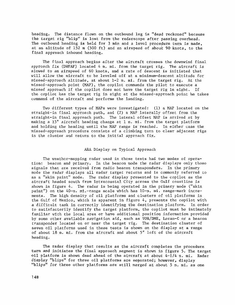
The weather-mapping r ada r used i n these tes ts had two modes of opera- t i o n : beacon and primary. I n t h e beacon mode the r ada r d i sp l ays only those s i g n a l s t h a t are received from r a d i o beacon t ransponders . I n the primary mode t h e r ada r d i s p l a y s a l l r a d a r t a r g e t r e t u r n s and is commonly r e f e r r e d t o as a "skin paint ' ' mode. The r a d a r d i s p l a y presented t o t h e c o p i l o t as t h e a i r c r a f t headed south from I n t r a c o a s t a l C i ty a c r o s s t h e Gulf c o a s t l i n e is shown i n f i g u r e 4 . The r ada r i s being operated i n t h e primary mode ("skin pa in t" ) on t h e 40-11. mi.-range scale which has 10-n. m i . range-mark incre- ments. The high d e n s i t y of o i l plat forms and c l u s t e r s of o i l plat forms i n t h e Gulf of Mexico, which i s apparent i n f i g u r e 4 , presen t s t h e c o p i l o t w i th a d i f f i c u l t t a s k i n c o r r e c t l y i d e n t i f y i n g t h e d e s t i n a t i o n platform. In orde r t o s a t i s f a c t o r i l y i d e n t i f y t h e t a r g e t platform, t h e c o p i l o t must be in t ima te ly f a m i l i a r wi th t h e l o c a l area o r have a d d i t i o n a l p o s i t i o n information provided by some o t h e r a v a i l a b l e nav iga t ion a i d , such as VOR/DNE, Loran-C o r a beacon t ransponder loca t ed on o r nea r t he t a r g e t r i g . The d e s t i n a t i o n c l u s t e r of seven o i l p la t forms used i n these tests i s shown on t h e d i s p l a y a t a range of about 18 n. m i . from t h e a i rcraf t and about 5' l e f t of t h e a i r c r a f t heading.
The r ada r d i s p l a y t h a t r e s u l t s as the a i r c r a f t completes t he procedure t u r n and i n i t i a t e s t h e f i n a l approach segment i s shown i n f i g u r e 5. The t a r g e t o i l p la t form is shown dead ahead of t h e a i r c r a f t a t about 4-1/4 n . m i . Radar d i s p l a y "bl ips" f o r t h r e e o i l p la t forms are sepa ra t ed ; however, d i s p l a y "b l ips" f o r t h r e e o t h e r p la t forms are s t i l l merged a t about 5 n. m i . as one
7 48
t a r g e t due t o poor r e s o l u t i o n and excess ive ga in con t ro l . A l so showing, on t h e r a d a r d i s p l a y , merged as one t a r g e t a t about 5-1/2 n . m i . , are two s h i p s t h a t w e r e pass ing through t h e area.
The r a d a r d i s p l a y t h a t r e s u l t s a f t e r t h e a i r c r a f t has progressed f a r enough on f i n a l approach f o r t h e c o p i l o t t o switch t o t h e 5-n. mi.-range scale (1-n. m i . range-mark increments) i s shown i n f i g u r e 6. The t a r g e t o i l p la t form is st i l l dead ahead a t about 3-1/2 n . m i . , and t h r e e p la t forms are s t i l l m e r g e d ; however, t h e two s h i p s are now disp layed as s e p a r a t e t a r g e t s .
The r ada r d i s p l a y r e s u l t i n g a f t e r swi tch ing t o t h e 2.5-n. mi.-range scale (0.5-n. m i . range-mark increments) i s shown in f i g u r e 7. The t a r g e t platform is dead ahead a t about 1-1/4 n. m i . , and a l l p la t forms are now d i s - played as s e p a r a t e t a r g e t s . One p la t form has passed o f f t h e scope down and t o t h e l e f t . The c o p i l o t would cont inue t o g ive t h e p i l o t heading commands t o b r ing t h e t a r g e t p la t form "bl ip" down t h e c e n t e r cu r so r of t h e r ada r d i s p l a y u n t i l t h e l ead ing edge of t h e t a r g e t m e t t h e 1/2-n. m i . range mark, a t which po in t a landing o r missed approach would be executed.
ARA Target Mididentif icat ion
The test crews unanimously agreed i n t h e i r p o s t f l i g h t p i l o t question- n a i r e s t h a t t h e most d i f f i c u l t t a s k i n making a n a i rbo rne r ada r approach t o a c l u s t e r of o i l p la t forms is t a r g e t i d e n t i f i c a t i o n . This conclusion i s s t r o n g l y supported by t h e tes t r e s u l t s . Of t h e 90 approaches conducted i n primary mode t o t h e seven-r ig test c l u s t e r , 5 w e r e made t o wrong t a r g e t p l a t - forms, and 5 o t h e r s were made t o s h i p s i n the area; t h a t i s , 11% of t h e primary-mode r ada r approaches were conducted t o i n c o r r e c t t a r g e t s . The d i f - f i c u l t y of t a r g e t i d e n t i f i c a t i o n i s i l l u s t r a t e d i n t h e t y p i c a l d i s p l a y shown i n f i g u r e 7. *Due t o t h e wide r ada r antenna beam width ( 8 " ) , t a r g e t s are elongated i n azimuth, making p a t t e r n r ecogn i t ion very d i f f i c u l t ; t h e r e i s f u r t h e r confusion i f s h i p s are i n t h e area. I f a beacon i s loca ted i n t h e d e s t i n a t i o n o i l r i g c l u s t e r , use of t h e beacon mode can a i d t a r g e t i d e n t i f i - ca t ion . However, t h e r e are very few beacons a t o f f shore o i l r i g s , and f u t u r e i n s t a l l a t i o n s are unce r t a in because of t h e expense and p o s s i b l e c o n f l i c t of beacons wi th m a r i t i m e r ada r s .
There i s usua l ly no hazard a s soc ia t ed wi th i n c o r r e c t t a r g e t i d e n t i f i c a - t i o n , i f a missed approach i s not requi red ; t h e p i l o t can simply l o c a t e him- s e l f upon arr ival a t t h e wrong p la t form and f l y t o t h e c o r r e c t p la t form i n t h e c l u s t e r . A s e r i o u s problem can be c r e a t e d , however, i n t h e event a missed approach is executed from t h e wrong t a r g e t because t h e a i r c r a f t may not have s u f f i c i e n t obs t ruc t ion c learance .
I n c o n t r a s t wi th a n approach t o a n o i l r i g c l u s t e r , an approach t o s i n g l e r i g does no t p re sen t such a s e r i o u s t a r g e t - i d e n t i f i c a t i o n problem. I n the case of a s ing le - r ig approach, t r a n s i e n t sh ipping p r e s e n t s t h e only t a r g e t i d e n t i f i c a t i o n d i f f i c u l t y .
1 4 9
ARA F i n a l Approach Lateral F l i g h t Envelope
The minimum descent a l t i t u d e i n these tests w a s no t based on ver t ical o b s t a c l e c learance , as i s the case i n convent ional instrument approaches. Rather t h e a i r c r a f t w a s flown a t minimum descent a l t i t u d e s on f i n a l approach t h a t placed i t below t h e tops of some surrounding o i l r i g s . p o s s i b l e by r e l y i n g on t h e a i r b o r n e r ada r t o provide s u f f i c i e n t la teral clear- ance from obs tac l e s i n t h e area and us ing t h e r ada r altimeter t o provide necessary v e r t i c a l c learance from the water su r face . cr i ter ia t h a t w i l l provide s a t i s f a c t o r y la teral o b s t a c l e c l ea rance , i t i s important t o analyze s t a t i s t i c a l l y the a c t u a l ground t r a c k re la t ive t o the intended ground t r a c k of t h e f i n a l approach (ground t r a c k t h a t passes through t h e downwind f i n a l approach f i x ) . An ensemble p l o t of i nd iv idua l f i n a l approaches i s shown i n f i g u r e 8. The i n d i v i d u a l f i n a l approach ground t r a c k s i n d i c a t e t h a t t h e a i r c r a f t crews accepted i n i t i a l c ross - t rack d e v i a t i o n a t t h e DWFAF and simply f lew homing-type approaches by keeping the t a r g e t p l a t - form centered on t h e r ada r d i sp l ay . The mean and 2-sigma cross- t rack devia- t i o n s of f i n a l approach ground t r a c k re la t ive t o intended f i n a l approach ground t r a c k are shown i n f i g u r e 9. The 2-sigma "envelope" can be c l o s e l y approximated by a +30° s e c t o r about t he intended f i n a l approach t r a c k . Thus, i f t he f i n a l approach area i s clear of known o i l p la t forms wi th in 230' of t he s e l e c t e d f i n a l approach ground t r a c k , t h e r e is a 95% p r o b a b i l i t y (2-sigma) of i ncu r r ing only shipping o r o t h e r t r a n s i e n t obs t ac l e s .
This w a s made
Thus, t o he lp e s t a b l i s h
A M Missed Approach Lateral F l i g h t Envelope
The a c c e p t a b i l i t y of weather minimums f o r instrument approaches i s l a r g e l y determined by r e s u l t i n g o b s t a c l e c l ea rance provided i n the missed- approach procedure. Lateral o b s t a c l e c learance from the t a r g e t p la t form of missed approaches conducted i n these tests, us ing t h e l a t e r a l l y o f f s e t MAP, is shown i n f i g u r e 10. The mean missed-approach ground t r a c k had a minimum la teral c l ea rance from t h e t a r g e t p la t form of 625 m (2,050 f t ) wi th a 2-sigma dev ia t ion of k427 m (k1,400 f t ) . Based on t h e s e s ta t i s t ics , t h e p r o b a b i l i t y of ove r f ly ing t h e t a r g e t p la t form i n t o t h e c l u s t e r area i s 0.2%, i f t h e d i s - t r i b u t i o n i s assumed t o be normal.
ARA Weather Minimums
Weather minimums recommended by t h e s u b j e c t test p i l o t s are shown i n t a b l e 1. It is s i g n i f i c a n t t h a t a l though 25% of the approaches w e r e con- ducted t o 1/4-n. m i . minimums f o r test purposes, none of t h e 15 p i l o t s rec- ommended t h a t 1/4-n. m i . minimums be o p e r a t i o n a l l y approved f o r e i t h e r primary- o r beacon-mode approaches. Most of the p i l o t s recommended t h a t 6 1 m (200 f t ) , 1/2-n. m i . weather minimums be approved, bu t a cons iderable number f e l t that 9 1 m (300 f t ) , 1/2-11. m i . minimums would b e appropr i a t e ; a few thought t h a t t h e approved minimums should even b e h ighe r i n both a l t i t u d e and v i s i b i l i t y .
150
TEST RESULTS: MICROWAVE LANDING SYSTEM
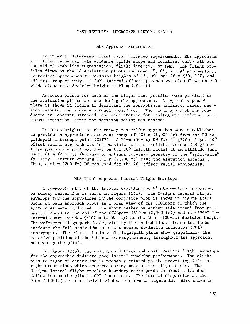
MLS Approach Procedures
I n o rde r t o determine "worst case" a i r s p a c e requirements , MLS approaches w e r e flown using r a w d a t a guidance ( g l i d e s lope and l o c a l i z e r only) without t he a i d of s t a b i l i t y augmentation, f l i g h t d i r e c t o r , o r DME. The f l i g h t pro- f i l e s flown by t h e 14 eva lua t ion p i l o t s included 3O, 6", and 9" g l ide-s lope , c e n t e r l i n e approaches t o dec i s ion h e i g h t s of 15, 30, and 46 m (50, 100, and 150 f t ) , r e s p e c t i v e l y . g l i d e s l o p e t o a dec i s ion he igh t of 61 m (200 f t ) .
A 20°, l a t e r a l - o f f s e t approach w a s a l s o flown on a 3'
Approach p l a t e s f o r each of t he f l i g h t - t e s t p r o f i l e s w e r e provided t o the eva lua t ion p i l o t s f o r use dur ing t h e approaches. A t y p i c a l approach p l a t e i s shown i n f i g u r e 11 dep ic t ing t h e appropr i a t e headings, f i x e s , dec i - s i o n he igh t s , and missed-approach procedures. The f i n a l approach w a s con- ducted a t cons tan t a i r speed , and d e c e l e r a t i o n f o r landing w a s performed under v i s u a l condi t ions a f t e r t h e dec i s ion he ight w a s reached.
Decis ion he igh t s f o r t h e runway c e n t e r l i n e approaches w e r e e s t a b l i s h e d t o provide an approximate cons tan t range of 305 m (1,000 f t ) from t h e DH t o g l idepa th i n t e r c e p t po in t (GPIP). A 15-m (50-ft) DH f o r 3' g l i d e s lope , 20' o f f s e t r a d i a l approach w a s n o t poss ib l e a t t h i s f a c i l i t y because MLS g l ide - s l o p e guidance s i g n a l w a s l o s t on t h e 20° azimuth r a d i a l a t an a l t i t u d e j u s t under 61 m (200 f t ) (because of antenna coverage geometry of t he " s p l i t - s i t e " f a c i l i t y - azimuth antenna 1341 m (4,400 f t ) p a s t t h e e l e v a t i o n antenna) . Thus, a 61-m (200-ft) DH w a s used f o r t h e 20' o f f s e t r a d i a l approaches.
MLS F i n a l Approach Lateral F l i g h t Envelope
A composite p l o t of t he la teral t r ack ing f o r 6" g l ide-s lope approaches on runway c e n t e r l i n e i s shown i n f i g u r e 12 (a ) . The 2-sigma la te ra l f l i g h t envelope f o r t he approaches i n the composite p l o t i s shown i n f i g u r e 12(b) . Shown on both approach p l o t s i s a p lan view of t he STOLport t o which t h e approaches w e r e conducted. The s h o r t dashes on e i t h e r s i d e extend from run- way th re sho ld t o t h e end of t h e STOLport (610 m (2,000 f t ) ) and r ep resen t t h e la teral course window ( + l o 7 m (+350 f t ) ) a t t h e 30 m (100-ft) dec i s ion h e i g h t . The r e fe rence f l i g h t p a t h i s depic ted by t h e dashed l i n e ; t h e do t t ed l i n e s i n d i c a t e t h e f u l l - s c a l e l i m i t s of t h e course dev ia t ion i n d i c a t o r (CDI) instrument . Therefore , t h e lateral f l i g h t p a t h p l o t s show g raph ica l ly t h e relative p o s i t i o n of t h e C D I needle displacement , throughout t h e approach, as seen by t h e p i l o t .
I n f i g u r e 12 (b ) , t h e mean ground t r a c k and s m a l l 2-sigma f l i g h t envelope f o r t h e approaches i n d i c a t e good la teral t r ack ing performance. The s l i g h t b i a s t o r i g h t of c e n t e r l i n e is probably r e l a t e d t o the p r e v a i l i n g l e f t - t o - r i g h t c r o s s winds which occurred dur ing most of t h e f l i g h t tests. The 2-sigma l a t e ra l f l i g h t envelope boundary corresponds t o about a 1 1 2 d o t d e f l e c t i o n on t h e p i l o t ' s C D I ins t rument . The la teral d i s p e r s i o n a t t h e 30-m (100-ft) dec i s ion he igh t window i s shown i n f i g u r e 13. Al so shown i n
151
f i g u r e 1 3 f o r comparison are t h e "2-dot" C D I window and t h e convent ional ILS CAT I1 window. he igh t window w a s 5 m (17-f t ) t o r i g h t of c e n t e r l i n e ; t h e 2-sigma lateral f l i g h t envelope a t t h e 30 m (100-ft) d e c i s i o n he igh t window w a s 237 m (k120 f t ) about t h e mean. 9' glide-s lope approaches w a s e s s e n t i a l l y equiva len t t o t h a t of t h e 6 O g l ide-s lope approaches. conducted o u t s i d e t h e MLS coverage area under dead reckoning. wide missed-approach pa th v a r i a t i o n s ev iden t on t h e composite approach p l o t ( f i g . 1 2 ( a ) ) r e s u l t e d from l a c k of nav iga t ion guidance dur ing t h i s pro- cedure. The MLS system can provide back-azimuth guidance f o r missed approaches when o p t i o n a l equipment i s provided.
The mean l a t e ra l f l i g h t p a t h a t t h e 30 m (100-ft) dec i s ion
The la teral t r a c k i n g performance f o r t h e 3' and
It should be noted t h a t missed approaches w e r e Thus, t h e
MLS F i n a l Approach Vertical F l i g h t Envelope
A composite p l o t of t he v e r t i c a l t r ack ing f o r 6" gl ide-s lope approaches on runway c e n t e r l i n e i s shown i n f i g u r e 1 4 ( a ) . The 2-sigma f l i g h t envelope f o r t h e approaches i n the composite p l o t i s shown i n f i g u r e 14(b) . The zero po in t roughly corresponds t o t h e g l ide-pa th i n t e r c e p t p o i n t (GPIP), o r t h e ex tens ion of t h e g l i d e s lope t o i t s i n t e r s e c t i o n wi th t h e runway. The r e f e r - ence f l i g h t p a t h i s dep ic t ed by t h e dashed l i n e , and the v e r t i c a l wedge def ined by t h e do t t ed l i n e s r e p r e s e n t s t h e f u l l - s c a l e l i m i t s (+2 d o t s ) of t he p i l o t ' s v e r t i c a l dev ia t ion i n d i c a t o r (VDI). Thus, t he ver t ica l f l i g h t p a t h p l o t s pro- v i d e a graphic i n d i c a t i o n of t he r e l a t i v e p o s i t i o n of t h e g l ide-s lope ind i - c a t o r through the complete approach.
The mean g l idepa th and s m a l l 2-sigma d e v i a t i o n s shown i n f i g u r e 14(b) i n d i c a t e good g l ide-s lope t r ack ing performance. The 2-sigma v e r t i c a l f l i g h t envelope boundary corresponds t o gene ra l ly about 3 / 4 of a do t d e f l e c t i o n on t h e p i l o t ' s V D I ins t rument . However, t h e r e w a s a tendency f o r t he a i r c r a f t t o arrive at t h e 30 m (100-ft) dec i s ion he igh t window s l i g h t l y high on g l i d e s lope , as i l l u s t r a t e d in f i g u r e 13. The mean f l i g h t p a t h a t t h e 30 m (100-ft) d e c i s i o n he ight window w a s 6 m (21 f t ) high, corresponding t o about 1-1/2 d o t s d e f l e c t i o n on t h e p i l o t ' s V D I instrument . envelope a t t h e 30 m (100-ft) d e c i s i o n he igh t window ranged from a lower boundary of 22 m ( 7 1 f t ) t o an upper boundary of 53 m (173 f t ) . The ver t ical f l i g h t p a t h d i spe r s ions f o r t h e 30, 6 O , and g o g l i d e s lopes w e r e e s s e n t i a l l y equ iva len t , as seen on t h e p i l o t ' s VDI. However, f u l l - s c a l e V D I d e f l e c t i o n s e n s i t i v i t y w a s va r i ed wi th g l i d e s l o p e ( f u l l - s c a l e de f l ec - t i o n = G S 0 / 3 ) . f l i g h t envelope of t h e 3 O g l i d e s l o p e w a s about 50% less than t h a t of t h e 6' g l i d e s lope , and t h e g o glide-s lope ver t ical f l i g h t envelop? w a s about 50% g r e a t e r t han t h a t of t h e 6 O g l i d e s lope .
The 2-sigma ver t ica l f l i g h t
Therefore , f o r equiva len t V D I d e f l e c t i o n , t h e a c t u a l
MLS Minimum Missed Approach A l t i t u d e
The minimum a l t i t u d e t o which an a i r c r a f t descends a f t e r i n i t i a t i o n of t h e missed approach i s an important parameter, f o r i t a f f e c t s t he e s t a b l i s h - ment of a n acceptab le d e c i s i o n he igh t f o r a p a r t i c u l a r f l i g h t p a t h geometry.
152
F l i g h t - t e s t d a t a f o r t he 3", 6", and 9" runway c e n t e r l i n e approaches w e r e analyzed t o determine t h e s t a t i s t i c a l means and 2-sigma d e v i a t i o n s of t he minimum a l t i t u d e t o which t h e a i r c r a f t descended a f t e r i n i t i a t i o n of t h e missed approach procedure. These d a t a are sho
A s one would expec t , t h e means and 2-si missed-approach a l t i t u d e inc rease wi th i n c r e ( s t eepe r g l i d e s lopes ) . The mean minimum missed-approach a l t i t u d e s w e r e 13, 23, and 36 m (43, 7 7 , and 118 f t ) f o r dec i s ion h e i g h t s of 15, 30, and 46 m (50, 100, and 150 f t ) , r e spec t ive ly . The 2-sigma (95% p r o b a b i l i t y ) missed-approach ver t ical envelopes f o r t h e same d e c i s i o n h e i g h t s w e r e bounded by minimum a l t i t u d e s of 8, 18, and 27 m (26, 58, and 87 f t ) , r e spec t ive ly .
MLS Decis ion Height P i l o t Rat ings
The p i l o t a c c e p t a b i l i t y r a t i n g s of t he d e c i s i o n h e i g h t s f o r t he 3" , 6 " , Eleven p i l o t s and 9" runway c e n t e r l i n e approaches are shown i n t a b l e 3.
r a t e d t h e 1 5 m (50-f t ) dec i s ion he igh t f o r t h e 3O g l i d e s l o p e acceptab le . High a i r speeds , t r ack ing e r r o r s , unacceptable o b s t a c l e c l ea rance , wind g u s t s , and turbulence w e r e s t a t e d as reasons by t h r e e p i l o t s who f e l t t h e 15 m (50-f t ) dec i s ion he ight w a s "too c l o s e t o t h e ground f o r manual f l i g h t . " A l l 14 p i l o t s r a t e d t h e 30 m (100-ft) dec i s ion he igh t "accept- able" f o r t h e 6O g l ide-s lope approaches. 46-m (150-ft) d e c i s i o n he ight acceptab le f o r t h e 9' approaches, and two r a t e d i t unacceptable. as t h e reasons f o r t h e unacceptable r a t i n g s .
Twelve p i l o t s considered t h e
Excessive s i n k rate and p i l o t workload w e r e s t a t e d
CONCLUDING REMARKS
J o i n t NASA/FAA h e l i c o p t e r f l i g h t tests have been conducted t o i n v e s t i - g a t e a i rbo rne r a d a r approaches ( A M ) and microwave landing system (MLS) approaches. F l i g h t - t e s t r e s u l t s have been u t i l i z e d t o provide (1) NASA wi th a d a t a base t o be used as a performance measure f o r advanced guidance and naviga t ion concepts and ( 2 ) FAA wi th d a t a f o r es tab l i shment of TEWS cr i ter ia . NASA is us ing t h e ARA test d a t a t o develop f l i g h t d i r e c t o r concepts which w i l l be superimposed on t h e r ada r d i s p l a y f o r improved t r ack ing and reduced p i l o t workload. f o r u s e of Airborne Radar f o r instrument approaches t o o f f shore o i l r i g s , which w i l l serve as a forerunner t o a c t u a l TEWS pub l i ca t ion . NASA i s us ing t h e MLS test d a t a t o develop advanced concepts f o r h i g h - t r a f f i c d e n s i t y oper- a t i o n s such as 3D/4D, h e l i c a l , d e c e l e r a t i n g approaches. The FAA i s us ing t h e MLS test d a t a as a b a s i s f o r suggested h e l i c o p t e r landing cr i ter ia i n t h e i r System T e s t and Evalua t ion Program (STEP), a program designed t o accomplish o p e r a t i o n a l implementation of t h e new Nat iona l Microwave Landing System.
The FAA has used t h e ARA test d a t a t o d r a f t an Advisory C i r c u l a r
153
REFERENCES
1. Parrish, Robert: The Offshore Transportation Industry. Business and Commercial Aviation, Jan. 1979.
2. National Plan for Development of the Microwave Landing System. FAA-ED- 07-2A, June 1978.
3 . United States Standard for Terminal Instrument Procedures. FAA Handbook 8260.3B, July 1976.
4 . Bul l , J. S.; Hegarty, D. M.; et al.: Flight Investigation of Helicopter IFR Approaches to Oil Rigs Using Airborne Weather and Mapping Radar. Paper 79-52, 35th Annual Forum of the American Helicopter Society, May 1979.
5. Phillips, J. D.; B u l l , J. S.; Hegarty, D. M.; and Dugan, D. C.: Naviga- tion Errors Encountered Using Weather Mapping Radar for Helicopter IFR Guidance to Oil Rigs. Helicopter Society, May 1980.
Paper 80-16, 36th Annual Forum of the American
6. Pate, D. P.; and Yates, J. H.: Airborne Radar Approach FAA/NASA Gulf of Mexico Helicopter Flight Test Program. FAA Report No. AFO-507-78-2, Jan. 1980.
7. Peach, L. L.; Bull, J. S.; et al.: NASAjFAA Flight Test Investigation of Helicopter Microwave Landing System Approaches. Paper 80-55, 36th Annual Forum of the American Helicopter Society, May 1980.
154
TABLE 1.- ARA WEATHER MINIMUMS RECOMMENDED BY SUBJECT TEST PILOTS
Weather minimum
200 f t , 1 / 4 n. m i . 0 0 200 f t , 1 / 2 n. m i . 7 10 300 f t , 1 / 2 n. m i . 4 3 Higher - 2
3" g l i d e s lope 6" g l i d e s l o p e 9" g l i d e s l o p e
50-ft d e c i s i o n 100-ft d e c i s i o n 150-ft d e c i s i o n he igh t he igh t he igh t
Mean minimum missed- approach a l t i t u d e , f t AGL
43.5 57.5 118.0
2-sigma d e v i a t i o n , f t 17.0 20.0 31.0
2-sigma (95% p r o b a b i l i t y ) 26.5 57.5 87.0 minimum a l t i t u d e , f t AGL
155
Figure 1.- B e l l 212 h e l i c o p t e r landing on o i l r i g i n t h e Gulf of Mexico.
Figure 2.- NASA UH- S approach (se lec ted
156
DWFAF
Figure 3.- Airborne r a d a r approach t o o f f s h o r e o i l r i g . 1 f t = 0.3048 m.
F igure 4.- Primary r ada r r e t u r n d i s p l a y looking south over Gulf c o a s t l i n e south of I n t r a c o a s t a l C i ty , Louis iana (40-n. mi.-range s c a l e ) .
157
Figure 5.- Primary r a d a r r e t u r n d i s p l a y on f i n a l approach (10-n. mi.-range scale).
F igu re 6.- Primary r a d a r r e t u r n d i s p l a y on f i n a l approach (5-n. mi.-range scale).
158
Figure 7.- Primary r a d a r r e t u r n d i sp lay on f i n a l approach (2.5-n. mi.-range s c a l e ) .
F igure 8.- ARA i nd iv idua l f i n a l approach ensemble p l o t .
159
2 0 e n
I-
> w
Y
3 5 P 0
Figure 9.- ARG f i n a l approach envelope.
-2(Nlo -1009 0 10 00 3000 4000 5000 6000 ET PLATFORM, ft
Figure 10.- ARA missed-appr e lope ( l a t e r a l l y offset M A P ) .
160
\’””” COPTER MLS ONLY
R a d a r vec tor to i n t e r c e p t MLS a z i m u t h D r i o r to 6 NM radar f i x requ i red .
6 R
2200 -
3s 6.00”
:ATEGORY i MLS 35
;S 6.00°
MISSED A P P R O A C H Climb s t ra igh t ahead t o 700
T h e n c l l m b i n g l e f t t u r n to
2200, head ing 190°. f o r radar vec tors to f i n a l
240/12 100 (RA 100)
Figure 11.- MLS
ELEV 166 R W Y 35 LDC 2000’
L1
35
, L A N D I N G , C A L I F O R N I A
:ROWS LANDING ALF RESTRICTED USE - EXPERIMENTAL ONLY
6* glide-slope approach plate. 1 ft = 0.3048 m.
161
-8000
-6Q00
2 0
4 2000
4000 I I 1 I I 1 I 1 J
-7 -6 -5 -4 -3 -2 -1 0 1 2 X POSITION, n. mi.
{a) Lateral composite.
LATERAL TWO SIGMA APPROACH ENVELOPE
100 f t DECISION HEIGHT STRAIGHT-IN, 6" GLIDESLOPE
FLIGHT ENVELOPE
(b) Lateral 2-sigma approach envelope.
Figure 12.- MLS composite i n d i v i d u a l approach and 2-sigma envelope p l o t s of l a t e r a l t r ack ing : c e n t e r l i n e , 6 O g l i d e s l o p e . 1 Et = 0.3048 m.
162
200 c Y
Lu
5 100 - I- - 5
ILS CAT II WINDOW 0 0
a 01 1 I I I I 1 I I -400 -300 -200 -100 0 100 200 300 400
LATERAL DISPLACEMENT (ft)
Figure 13.- MLS f l i g h t p a t h d i s p e r s i o n s a t 100-ft d e c i s i o n he igh t window f o r 6 O g l ide-s lope approaches. 1 f t = 0.3048 m.
F igu re 14.- MLS composite i n d i v i d u a l approach and 2-sigma envelope p l o t s of vertical and la teral t r ack ing : c e n t e r l i n e , 6' g l i d e s lope . 1 f t = 0.3048 m