6
Flood Related Planning Controls Moorabool 16 January 2018 Cardno i Flood Related Planning Controls Moorabool V171604 Prepared for Moorabool Shire Council & Melbourne Water 16 January 2018
Flood Related Planning Controls Moorabool
16 January 2018 Cardno i
Flood Related Planning Controls
Moorabool V171604
Prepared for Moorabool Shire Council & Melbourne Water 16 January 2018
Flood Related Planning Controls Moorabool
© Cardno. Copyright in the whole and every part of this document belongs to Cardno and may not be used, sold, transferred, copied or reproduced in whole or in part in any manner or form or in or on any media to any person other than by agreement with Cardno.
This document is produced by Cardno solely for the benefit and use by the client in accordance with the terms of the engagement. Cardno does not and shall not assume any responsibility or liability whatsoever to any third party arising out of any use or reliance by any third party on the content of this document.
V171604 | 16 January 2018 ii
Contact Information Document Information
Cardno Victoria Pty Ltd ABN 47 106 610 913
Level 4
501 Swanston Street
Melbourne 3000
Australia
www.cardno.com
Phone +61 3 8415 7777
Fax +61 3 8415 7788
Prepared for Moorabool Shire Council &
Melbourne Water
Project Name Moorabool
File Reference V171604_R001_V001.docx
Job Reference V171604
Date 16 January 2018
Version Number 001, Client Issue
Author(s):
Name Ailsa Veldema
Job title Senior Flood Analyst
Effective Date 16/01/2018
Approved By:
Name Ailsa Veldema
Job title Senior Flood Analyst
Date Approved 16/01/2018
Document History Version Effective Date Description of Revision Prepared by Reviewed by
001 01/12/17 Client Issue Ailsa Veldema Ailsa Veldema
002 16/01/18 Final Ailsa Veldema Ailsa Veldema

Flood Related Planning Controls Moorabool
V171604 | 16 January 2018 iii
Table of Contents
1 Introduction 1 2 Background 1 3 Information used and Methodology 1 4 Overlays 1
Figures
Figure 4-1 Proposed Overlay 2 Figure 4-2 Overlay Comparison 3

Flood Related Planning Controls Moorabool
V171604 | 16 January 2018 1
1 Introduction
This has been prepared to accompany the proposed Special Building Overlay (SBO) for Moorabool, December 2017. It provides a background, describes what information has been used in the development and provides details of the overlay.
2 Background
Melbourne Water (MW) and Moorabool Shire Council (Council) prepared flood related planning overlays for potential inclusion into the Moorabool Planning Scheme. The overlays consisted of proposed Land Subject to Inundation Overlays (LSIO) and Special Building Overlays (SBO). MW and Council engaged Cardno to undertake an independent review of the technical methodology used to determine the location and shape of the proposed planning overlays. The report ‘Peer Review Moorabool Shire Flood Modelling’ (V170467, November 2017) documents the review.
It was concluded that the flood model from the Lower Lerderderg Catchments Flood Mapping project was suitable for use. However, the methodology adopted to convert the outputs to a planning overlay should be modified and the overlays be amended accordingly.
3 Information used and Methodology
Hydraulic modelling results from the Lower Lerderderg Catchments Flood Mapping project were used as inputs into the flood overlay and the process below followed.
> Step 1: Filter flood results to remove areas with shallow (less than 0.05 m) flooding;
> Step 2: Combine the above results into a single shape and remove both wet “puddles” or dry “islands” if the area is less than 100 m2.
> Step 3: Smooth the shape to remove the ‘staircase’ effect associated with modelling grid cells.
> Step 4: Split the shape into MW and Council controlled areas based on the splits adopted in the previous overlays and on the source of flooding (i.e. if inundation emanates from a MW asset then is classified as MW flooding). Remove the Council areas as the amendment is for MW controlled areas only.
> Step 5: Based on MW’s document ‘Finalising Flood Extents for Inclusion in Planning Schemes’ review the overlay at the property scale. In summary, properties which had less than 2% of their total area inundated were considered for removal. If more than 25% of their frontage was affected or the area is considered at risk based on the various flood depths experienced, the overlay was retained on the property.
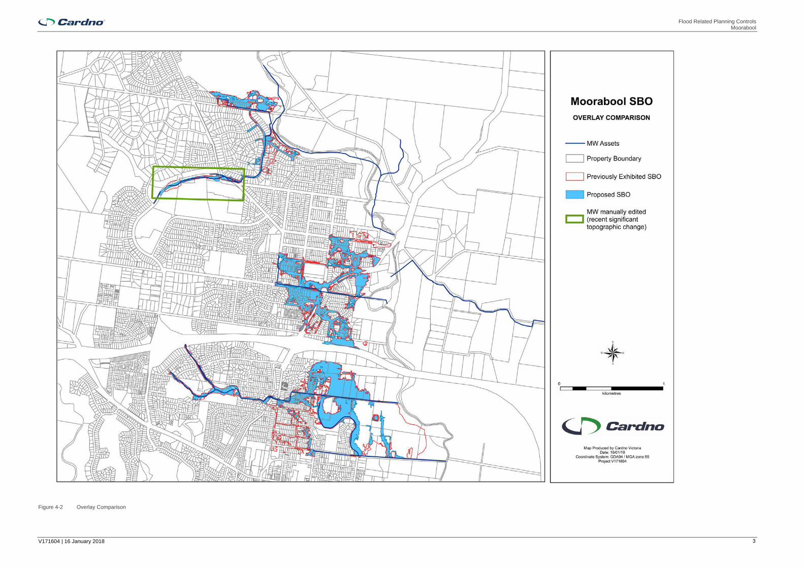
The draft overlay produced using the above process was supplied to MW for review. During this review an area (at Cairns Drive DS) was updated by MW to be more reflective of the topography which had recently been significantly modified as part of development works.
4 Overlays
The revised Special Building Overlay is shown on Figure 4-1 overleaf.
Figure 4-2 shows this proposed overlay alongside the previously exhibited overlay. Whilst there are a number of changes, the key area of change is in the rural land south of Masons Lane. The proposed overlay is significantly reduced from that which was previously exhibited.
It is recommended that the proposed SBO is adopted and the planning scheme amendment process be recommenced.

Flood Related Planning Controls Moorabool
V171604 | 16 January 2018 2
Figure 4-1 Proposed Overlay
Flood Related Planning Controls Moorabool
V171604 | 16 January 2018 3
Figure 4-2 Overlay Comparison


