Page 1
the Mississippi River in western
Wisconsin.
Tragically, this event included the
loss of two lives in Vernon
County. On September 22, 2016,
a man died after a mudslide
swept down a hill and destroyed
his home while he was inside. A
second man died on September
23, 2016, while pulling a horse
trailer with his pickup truck; he
drowned after swiftly moving
water on top of a road surface
swept his vehicle downstream.
This event impacted over 485
homes and left behind tens of
millions of dollars in public sec-
tor damage. Both the initial
storm and the flooded rivers
through September 29, 2016
caused excessive road damage
and generated large amounts of
debris. For many counties, this
was the fourth major storm and
flood event since June 2016,
resulting in intensified stress for
citizens and local emergency
response efforts.
If you have questions relating to
PA and HMGP funding, please
contact Roxanne Gray, Mitiga-
tion Section Supervisor, Wiscon-
sin Emergency Management at
608-242-3211 or by e-mail at
[email protected] . If
you have questions about flood-
plain management, please contact
Michelle Staff, Floodplain Policy
Coordinator, at (608) 266-3093
o r b y e - m a i l a t
[email protected] .
On October 20, 2016, President
Barack Obama issued a Major
Presidential Disaster Declaration,
resulting in Federal Emergency
Management Agency (FEMA)
Public Assistance (PA) being
made eligible to applicants in ten
counties and Hazard Mitigation
Grant Program (HMGP) funding
available throughout the state for
severe storms that occurred on
September 21-22, 2016, with
flooding through September 29,
2016. Declared counties: Adams,
Chippewa, Clark, Crawford,
Jackson, Juneau, La Crosse, Mon-
roe, Richland, and Vernon.
PA provides assistance to state
and local governments and cer-
tain private nonprofit organiza-
tions for emergency work and
the repair or replacement of
disaster-damaged facilities, as
well as assistance for debris re-
moval and emergency protective
measures. The HMGP provides
assistance to eligible applicants
for actions taken to eliminate or
reduce long-term risk to life and
property from natural hazards.
All counties in the State of Wis-
consin are eligible to apply for
assistance under the HMGP.
Beginning on Wednesday, Sep-
tember 21, 2016, and extending
through Thursday, September
22, 2016, multiple rounds of
severe thunderstorms impacted
much of west central through
southwestern Wisconsin. During
this two day period, the area
received over ten inches of pre-
cipitation; the heaviest rains
resulted in flash flooding
throughout the evening hours.
Since the area experienced satu-
rated soils and vegetative condi-
tions due to high rainfalls over
the preceding month, stream,
riverine, and urban flooding de-
veloped faster than normal, re-
sulting in mudslides, washouts,
and flooding on roadways.
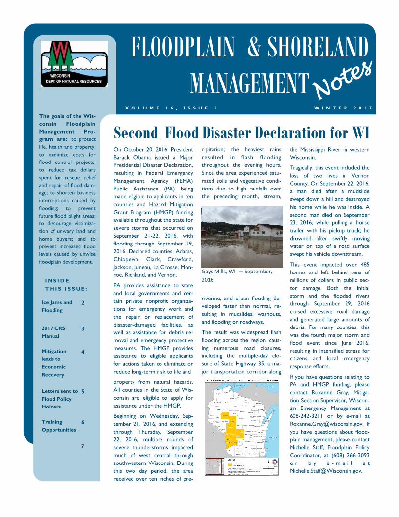
The result was widespread flash
flooding across the region, caus-
ing numerous road closures,
including the multiple-day clo-
sure of State Highway 35, a ma-
jor transportation corridor along
Gays Mills, WI — September,
2016
Second Flood Disaster Declaration for WI
I N S I D E
T H I S I S S U E :
Ice Jams and
Flooding
2
2017 CRS
Manual
3
Mitigation
leads to
Economic
Recovery
4
Letters sent to
Flood Policy
Holders
5
Training
Opportunities
6
7
FLOODPLAIN & SHORELAND
MANAGEMENT W I N T E R 2 0 1 7 V O L U M E 1 6 , I S S U E 1
Note
s
The goals of the Wis-
consin Floodplain
Management Pro-
gram are: to protect
life, health and property;
to minimize costs for
flood control projects;
to reduce tax dollars
spent for rescue, relief
and repair of flood dam-
age; to shorten business
interruptions caused by
flooding; to prevent
future flood blight areas;
to discourage victimiza-
tion of unwary land and
home buyers; and to
prevent increased flood
levels caused by unwise
floodplain development.
Page 2
P A G E 2
F L O O D P L A I N & S H O R E L A N D M A N A G E M E N T
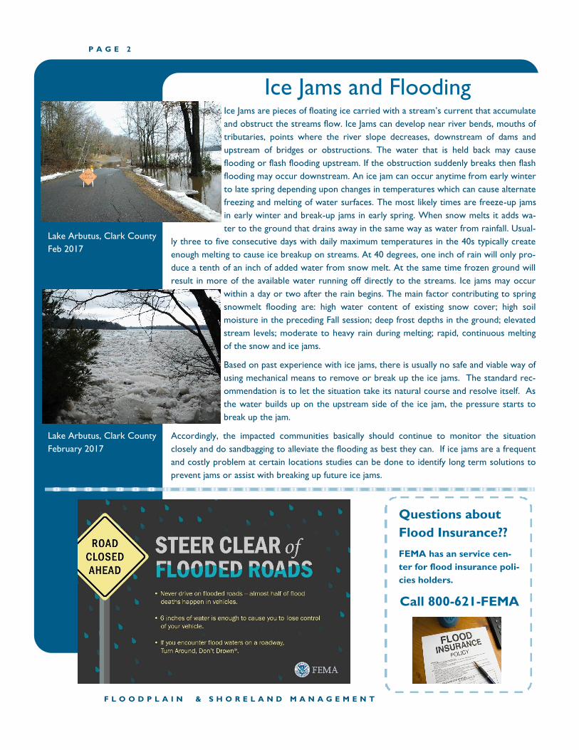
Ice Jams and Flooding Ice Jams are pieces of floating ice carried with a stream’s current that accumulate
and obstruct the streams flow. Ice Jams can develop near river bends, mouths of
tributaries, points where the river slope decreases, downstream of dams and
upstream of bridges or obstructions. The water that is held back may cause
flooding or flash flooding upstream. If the obstruction suddenly breaks then flash
flooding may occur downstream. An ice jam can occur anytime from early winter
to late spring depending upon changes in temperatures which can cause alternate
freezing and melting of water surfaces. The most likely times are freeze-up jams
in early winter and break-up jams in early spring. When snow melts it adds wa-
ter to the ground that drains away in the same way as water from rainfall. Usual-
ly three to five consecutive days with daily maximum temperatures in the 40s typically create
enough melting to cause ice breakup on streams. At 40 degrees, one inch of rain will only pro-
duce a tenth of an inch of added water from snow melt. At the same time frozen ground will
result in more of the available water running off directly to the streams. Ice jams may occur
within a day or two after the rain begins. The main factor contributing to spring
snowmelt flooding are: high water content of existing snow cover; high soil
moisture in the preceding Fall session; deep frost depths in the ground; elevated
stream levels; moderate to heavy rain during melting; rapid, continuous melting
of the snow and ice jams.
Based on past experience with ice jams, there is usually no safe and viable way of
using mechanical means to remove or break up the ice jams. The standard rec-
ommendation is to let the situation take its natural course and resolve itself. As
the water builds up on the upstream side of the ice jam, the pressure starts to
break up the jam.
Accordingly, the impacted communities basically should continue to monitor the situation
closely and do sandbagging to alleviate the flooding as best they can. If ice jams are a frequent
and costly problem at certain locations studies can be done to identify long term solutions to
prevent jams or assist with breaking up future ice jams.
Questions about
Flood Insurance??
FEMA has an service cen-
ter for flood insurance poli-
cies holders.
Call 800-621-FEMA
Lake Arbutus, Clark County
Feb 2017
Lake Arbutus, Clark County
February 2017
Page 3
2017 Edition of Coordinator’s Manual Is on the Way
P A G E 3 V O L U M E 1 6 , I S S U E 1
In accordance with its routine three-year cycle, the CRS is anticipating the release of an updated version of the CRS Coordinator’s Manual any
day now. The draft document is undergoing final review at the Office of Management and Budget to ensure adherence with the requirements
of the Paperwork Reduction Act. When OMB issues its final approval, the new Coordinator’s Manual will be available for download at
www.CRSresources.org and at other sites. There will be no major changes in the 2017 Coordinator’s Manual. Instead, you will find multiple
improvements, clarifications, and minor corrections. None of this will require substantive changes to a community’s CRS program or proce-
dures. Some of the 2017 changes are discussed below. Appreciation is extended to all the communities and others who have contributed their
suggestions for these ongoing improvements to the Coordinator’s Manual.
Communities do not need to change their preparation for the next verification visit. Just get ready as you always do. A commu-
nity’s coverage under the new edition will be phased in and the ISO/CRS Specialist will work with the community to spot any
different documentation or other changes that will apply in the future.
When approved, the 2017 Coordinator’s Manual will be available for download at www.CRSresources.org and also will be
posted on the website of the Federal Emergency Management Agency.
Changes from previous editions will be marked with vertical bars in the margins of the pages of the 2017 Coordinator’s Manual.
This will help you spot places that you may want to review, to see if the change affects your community.
The CRS has always credited mapping and regulations that account for future conditions and for sea level rise. The 2017 Coor-
dinator’s Manual establishes a sea level rise standard for crediting communities that assess and manage the changes anticipated
from changing sea levels. The CRS has chosen to require, at a minimum, that communities use the “intermediate-high” projec-
tion for 2100, from the report Global Sea Level Rise Scenarios for the U.S. National Climate Assessment. This report was pub-
lished by the National Oceanic and Atmospheric Administration’s Climate Program Office in collaboration with 10 federal and
academic science institutions.
The U.S. Army Corps of Engineers’ website offers a Sea-Level Change Curve Calculator that communities can use for purposes
of CRS credit. Website links and instructions for determining the sea level rise for a community will be available on
www.CRSresources.org and on www.FEMA.gov.
The frequency of cycle visits for some communities will be changing, for the first time in the history of the CRS. In 2010, as part
of the implementation of the CRS Strategic Plan, the CRS Task Force began considering whether the total dollar discount pro-
vided to a CRS community should be a consideration in determining the frequency of CRS credit verification. Beginning with the
2017 Coordinator’s Manual, those communities receiving the top 10% of premium discount dollars, along with the Class 1–4
communities, will be verified every 3 years. All other communities will be verified every 5 years. This change will be phased in
over the next 5 years. There will be no change to the timing of your next cycle visit.
Credit for channel debris removal (CDR) will no longer be a prerequisite for all other credit under Activity 540 (Drainage Sys-
tem Maintenance). This is part of a subtle re-alignment of credit under this activity, in response to the recognition that capital
improvement programs for drainage (credited as CIP) and maintenance of problem sites (credited as PSM), for example, are
important to all communities—regardless of whether their drainage system is “natural,” underground, engineered, or a combi-
nation—and thus should be eligible for CRS credit. This will provide more flexibility to communities to address their drainage-
related flood problems and still qualify for CRS credit.
CRS Category C repetitive loss communities are being re-defined as those with 50 or more repetitive loss properties
(compared to 10 or more such properties previously). Under the 2017 definition, there will be fewer Category C communi-
ties. The 2017 Coordinator’s Manual clarifies that Category C communities must either prepare and adopt a Repetitive Loss
Area Analysis (RLAA) for all repetitive loss areas, or prepare and adopt a floodplain management plan (FMP) that includes a
problem assessment of all repetitive loss areas and a review of flood insurance claims. You can find details about the FMP plan-
ning in Section 512.a of the 2017 Coordinator’s Manual, and about the RLAA in Section 512.c. This is not a completely new
idea, because Category C communities usually conduct these sorts of plans and assessments for their repetitive loss properties.
However, many floodplain management plans and/or disaster mitigation assistance plans currently do not meet the require-
ments of CRS Activity 510 Floodplain Management Planning Step 5(c). Going forward, all Category C communities that do not
produce a RLAA will have to earn full credit in Planning Step 5(c) for FMP.
For more information about the CRS Program, please contact Michelle Staff, WI NFIP Coordinator at 608-266-3093 or by e-mail at
[email protected] or Lou Ann Patellaro, ISO/CRS Specialist at 954-651-5021 or e-mail at [email protected] .
Page 4
P A G E 4
Mitigation Leads to Preservation and Economic Recovery Darlington, WI — Located in the southwest-
ern corner of Wisconsin, this rural city was
founded beside the Pecatonica River and
officially given the name of Darlington in
1869. Darlington is also the county seat and
home of the Lafayette County Fair. During
the past 172 years, this beautiful community
has been at odds with the Pecatonica River.
Numerous times the river wreaked havoc
with its destructive force, leaving a trail of
mud, debris and bacteria, contributing finan-
cial stress to both families and businesses.
Repetitive flooding deteriorated structures
and lowered property values. Owners experi-
enced substantial loss of business during the
times of flooding, cleanup and repair. The
buildup of mold and mildew in constantly
flooded structures led to unhealthy condi-
tions in the buildings.
Most of the buildings date back to the mid-1800s and are
of considerable historic importance. The continual flood-
ing is well documented and photographed from 1937 and
into the 1950s, its toll clearly imprinted on the faces of
the Darlingtonians shown. As townspeople tired of the
onslaught of the relentless river, many considered leaving
town for good. Others closed long-time businesses and
abandoned properties that were quickly becoming unsal-
able. Property values plummeted. It had become painfully
clear that the multiple floods of the past 50 years had
taken a terrible toll on Darlington. Something had to be
done.
After the 1993 flood, the community
adopted four goals, as part of a compre-
hensive plan, in order to retain the histor-
ic and community value of Darlington’s
Main Street as well as to mitigate against
future flood damage:
1. Preserve the historic downtown
business district
2. Restore the downtown economic
base
3. Develop an urban river open space park and recrea-
tion area.
4. Eliminate or substantially reduce flood damage in
the future.
The success in reaching the city’s goals depended on
forming an interagency coalition and promoting the co-
operation of government — local, state, and federal—
and businesses. Multiple agencies contributed
grants and/or expertise to the projects, including:
Federal Emergency Management Agency
(FEMA)
Wisconsin Emergency Management
Wisconsin Department of Natural Resource
Wisconsin Department of Commerce
Wisconsin Department of Administration
Wisconsin Historical Society
Economic Development Administration
Southwest Wisconsin Regional Planning Com-
mission
In developing the mitigation goals, officials ensured
efforts were locally-
based by involving
civic leaders, business
owners and residents
in the planning. The
plan included acquisi-
tion and demolition of
businesses adjacent to
the river that are
subject to severe
flood damage (several
contaminated proper-
ties from oil related
businesses were
cleaned up after the
a c q u i s i t i o n /
demolition projects).
Historic buildings in
the downtown busi-
ness district were
retrofitted while
maintaining their
historic character.
The engineered solu-
tion was to build a
vestibule area as you
step into the front door, at street level. Steps lead
up to the elevated first floor level, and a floodwall
separates the vestibule level from the first floor.
(photos right)
The downtown district wasn’t Darlington’s only
concern though. Adjacent neighborhoods and busi-
nesses also were being swamped by flood waters.
Homes and their utilities were elevated above
flood waters. The city acquired and demolished 13
commercial properties and developed a
Continue on next page...
F L O O D P L A I N & S H O R E L A N D M A N A G E M E N T
Pecatonica River
Darlington, WI
Photo taken by Michelle Staff
Elevated electrical panel at
the Pecatonica River Trails
Campground
Photo taken by Michelle Staff
Elevated floors inside store where
flood gate would be installed.
Outside of store pictured above
Page 5
Darlington article continued,
P A G E 5 V O L U M E 1 6 , I S S U E 1
33 acre business park up and away from the floodplain for relocated and new businesses.
The vacated land near the river was turned into a riverside park with a 1.2 mile paved trail,
campground and open green space. A portion of a 39 mile tri-county multi-use trail also
runs the park. To help address the downtown flooding problem, flood shields were de-
signed to prevent flood waters from entering the downtown businesses. Made of a corro-
sion-proof aluminum, the shields would be clamped to rigid steel stanchions. The stanchions
were to be cast into the top concrete entry portals, leading into the structure. Darlington
officials approved fabrication of the flood shields at a total cost of about $200,000. Each of
the 150 shields are numbered and lettered for the specific buildings on which they would be
installed. Early warning from flood gauges up-river at Calamine, WI, affords Darlington at
least eight hours notice before flood waters reach the town.
Property owners were required to purchase flood insurance if they did not already have a
policy. A major benefit of the entire project was a dramatic increase in property values city
-wide. One city office official estimates that property values for the refurbished commercial
buildings along the old main street have nearly doubled.
For more information hazard mitigation, please contact Katie Sommers, State Hazard Miti-
gation Officer at (608) 242-3222 or [email protected] . For questions on flood-
plain management, please contact Michelle Staff, DNR Floodplain Policy Coordinator at
(608) 266-3093.
Elevated House in Darlington, WI
The Homeowner Flood Insurance Affordability Act of 2014 (HFIAA), section 28 required FEMA to clearly communicate full flood risk
determinations to individual property owners. The National Flood Insurance Program reviewed every flood insurance policy
and is writing to all NFIP policyholders to explain the current risk level for their property and the relation of the risk to their
premium rates.
As you may be aware, HFIAA requires gradual insurance rate increases for properties currently receiving subsidized rates, and
requires increases to premiums for most subsidized properties of no less than 5 to 15 percent annually, but no more than 18
percent for an individual policyholder--with limited exceptions--until the premium reaches its full-risk insurance rate.
Starting January 2017, policyholders will begin receiving letters about two months after their policy renews. Policyholders who
renewed policies in October 2016 through December 2016 will also receive their first mailing. FEMA will continue to mail the
letter at each subsequent renewal. Because policy information varies from one policy to the next, the letters encourage policy-
holders to contact their insurance agent to discuss their unique situation, or visit FEMA.gov/cost-of-flood to learn about their
options.
All policyholders will eventually receive a letter upon the renewal of their policy. The NFIP has identified seven categories of
policyholders to receive unique information based on their risk and current premium rates. The letters for each policyholder
category are as follows:
Letter A: Newly mapped into the Special Flood Hazard Area, or high risk flood zone
Letter B: Standard X Zone (moderate risk), not grandfathered
Letter C: Standard X Zone (moderate risk), grandfathered
Letter D: Pre-FIRM subsidized, primary residences
Letter E: Pre-FIRM subsidized, non-primary residences and businesses
Letter F: Preferred Risk Policy (PRP)
Letter G: Post-FIRM, full risk
Information for insurance agents, copies of each category of letter, details about what each letter means, and tips for how indi-
vidual policyholders can lower their flood risk (and potentially their flood insurance premiums) can be found at FEMA.gov/cost-
of-flood. Here is a PDF of a list of Frequently Asked Questions.
FEMA Letters: Flood Risk and Policy Options
Page 6
P A G E 6
Flooodplain Management Training Opportunities
Webinars on the Community Rating System The CRS Webinar Series provides training opportunities to communities
that are not yet participating in the Community Rating System or local gov-
ernment staff that are new to the CRS, and to local government staff with
experience in the CRS. The Series includes basic introductory sessions and more advanced topics,
most averaging about an hour in length. All classes 1:00 pm Eastern/10:00 am Pacific.
F L O O D P L A I N & S H O R E L A N D M A N A G E M E N T
2017 Schedule
Date Title
March 21 Preparing for a Verification Visit
March 22 Changes in the 2017 CRS Coordinator’s Manual
April 18 The Role of the Community CRS Coordinator
April 19 Repetitive Loss Properties and the CRS
May 16 Introduction to the CRS
May 17 CRS and Coastal Hazards
June 20 Preparing for a Verification Visit
June 21 Developing Outreach Projects (Activity 330)
The NFIP through the Emergency Management Institute (EMI) offers free webi-
nars on a variety of topics, including map changes and recent legislation
through the Emergency Management Institute. Upon successfully passing the
exam, you will receive a Certificate of Achievement to use as your proof of
training.
EMI Independent Study Program—Webinars Engineering Principles and Practices for Retrofitting Flood-Prone Residential Structures (IS-279.A)
Overview of: Engineering Principles and Practices for Retrofitting Flood-prone Restructures (IS-
280)
Using the Substantial Damage Estimator 2.0 Tool (IS-284)
Increased Cost of Compliance (IS-1100.a)
The Basic Agent Tutorial (IS-1101)
Theory of Elevation Rating (IS-1102)
Elevation Certificate for Surveyors (IS-1103)
EC Made Easy: Elevation Certificate Overview (IS-1105)
FEMA Mapping Changes (IS-1106)
Insuring Condominiums (IS-1108)
Writing Commercial Exposures (IS-1110)
Coastal Barrier Resources Act (IS-1113)
Courses at the National Emergency Training Center—2017
April 24, 2017 — E0282 Advanced Floodplain Management Concepts II
May 22, 2017 — E0273 Managing Floodplain Development through the NFIP
May 22, 2017 — E0279 Retrofitting Flood prone Residential Buildings.
June 26, 2017 — E0278 NFIP/Community Rating System
July 24, 2017 — E0284 Advanced Floodplain Management Concepts III
August 21, 2017 — E0273 Managing Floodplain Development through the NFIP
September 11,2017 — E0278 NFIP/Community Rating System
Page 7
Association of State Floodplain Managers National Conference
P A G E 7 V O L U M E 1 , I S S U E 1
The Association
of State Flood-
plain Managers is
an organization of
professionals in-
volved in flood-
plain manage-
ment, flood haz-
ard mitigation,
National Flood
Insurance Pro-
gram, and flood preparedness,
warn in g and re cove ry .
ASFPM is a respected voice in
floodplain management practice
and policy in the United States
because it represents flood hazard
specialists of local, state and federal
government, research community,
insurance industry and the fields of
engineering, hydrologic forecasting,
emergency response, water re-
sources and others.
The ASFPM annual conference is
recognized as the most important
floodplain conference in the United
States year after year. With more
than 120 speakers and 1,200 partici-
pants, they are the national confer-
ences all community, state and fed-
eral floodplain managers plan to
attend. And because of that, many of
the most important consulting firms
and product vendors associated
with floodplain management attend.
The 2017 ASFPM National Confer-
ence will take place at the Kansas
City Convention Center in Kansas
City, Missouri, April 30-May 5,
2017. The Kansas City Convention
Center is connected to major
downtown hotels and parking by
skywalks and underground walk-
ways. For more information on the
ASFPM National conference, visit
the ASFPM web site.
restore would equal or exceed 50 percent of
its equalized assessed value.
Zoning nonconformities are existing uses,
structures or lots that were legally established
prior to a change in zoning provisions and
which do not comply with today’s ordinance
standards. This floodplain provision applies to
structures that were already present at the
time a community adopted a flood hazard
ordinance or where Flood Insurance Rate
Map (FIRM) changes resulted in a higher Re-
gional Flood Elevation (RFE) or change in
FIRM flood zone.
The intent of this SI/SD provision is to pre-
vent existing buildings from being turned into
a new or substantially different building, which
would contribute to the longevity or perma-
nence of the building and affect the structural
quality of the building. A residence built today
is expected to last an average of about 100
years. The purpose of the non-conforming
provisions is to encourage gradual elimination
of nonconformities. If a local official deter-
mines that improvements or repairs to a
building constitute SI/SD, then the building
must be brought into compliance with the
NFIP floodplain management requirements for
new construction in Special Flood Hazard
Area (SFHA). New buildings and substantially
improved buildings must have their lowest
floors (including basements) elevated to or
above the Flood Protection Elevation (FPE)
in Wisconsin. The FPE is 2 feet above the 1-
percent annual chance flood or 100-year
flood.
The formula for determining substantial
improvement and substantial damage is
based on the cost of the project and the
equalized assessed value of the structure.
These two numbers must be reviewed in
detail. The cost of a project includes all
structural costs including material, labor,
built-in appliance, overhead and profit. The
formulas apply to the cost to repair or im-
prove, not the cost of repairs or improve-
ments. Permits should have applicants (or
their contractors) provide detailed descrip-
tions of the proposed work and detailed
breakdowns of the costs of work, as this
information is essential for making SI/SD
determinations.
Local officials in communities that participate
in the NFIP determine whether proposed
work qualifies as a substantial improvement
or repair of substantial damage. Any ques-
tions regarding this topic, contact Michelle
Staff, State NFIP Coordinator at
[email protected] .
The National Flood Insurance Program
(NFIP) underwrites flood insurance cover-
age only in communities that adopt and
enforce floodplain regulations that meet
or exceed NFIP criteria. When a proposal
is made to develop within a flood hazard
area, application of the criteria set forth in
Federal regulation (Title 44 Code of Fed-
eral Regulations [CFR] Section (§) 60.3) is
intended to minimize exposure and flood-
related damage.
Among these criteria are “substantial im-
provement” (SI) and “substantial dam-
age” (SD) requirements. Many buildings
have been flooded, repaired or rebuilt, and
flooded again. The purpose of the SI/SD
requirements is to protect the property
owner’s investment and safety, and, over
time, to reduce the total number of build-
ings that are exposed to flood damage,
thus reducing the burden on taxpayers
through the payment of disaster assis-
tance. Substantial improvement is defined
as any reconstruction, rehabilitation, addi-
tion, or other improvement of a structure
whose cost equals or exceeds 50 percent
of the structure’s equalized assessed value.
Substantial damage is damage by any origin
sustained by a structure whose cost to
Substantial Improvement and Substantial Damage under the NFIP
Page 8
P A G E 8
Annual Report of the Flood Insurance Advocate’s
We are pleased to announce the second Annual Report of the Office of the Flood Insurance Advo-
cate (OFIA) is now live on FEMA.gov. This report is being released publicly to further the OFIA’s
goal of transparency and can be found at https://www.fema.gov/national-flood-insurance-program-
flood-insurance-advocate, under Information about the OFIA, by clicking the Annual Report.
The OFIA identified six primary policyholder and property owner frustrations in 2016 that present
opportunities for ongoing program improvement. These issues are: Erroneous Severe Repetitive
Loss (SRL) property designations; gaps in flood insurance agent education; the need for consistency
across FEMA Regions in public mapping outreach; difficulties in accessing Increased Cost of Com-
pliance (ICC) coverage; difficulties with multiple and conflicting flood zone determinations; and
inability to obtain a refund of the Homeowners Flood Insurance Affordability Act of 2014 (HFIAA)
surcharge when cancelling a National Flood Insurance Program (NFIP) policy.
The issues identified in this report are based on the observations of OFIA through the hundreds of
inquiries submitted to the Office this past year. These issues represent areas of concern that have
a long-term impact to a broad population of NFIP customers. The Federal Insurance and Mitigation
Administration’s (FIMA) program areas were provided an opportunity to respond to these findings
and responses are included with this report.
The OFIA is an independent office within FEMA with direct alignment to the FIMA Associate Ad-
ministrator and the FEMA Administrator. The OFIA will make this report and subsequent reports
available via its webpage.
The mission of the OFIA is to advocate for the fair treatment of policyholders and property own-
ers by providing education and guidance on all aspects of the NFIP, identifying trends affecting the
public, and making recommendations for program improvements to FEMA leadership. Policyhold-
ers who are confused and frustrated may seek assistance from the OFIA by visiting their webpage
and clicking on “Ask the Advocate,” though we do ask that policyholders and property owners
continue to utilize existing NFIP resources to address questions related to their flood policies be-
fore requesting assistance from the OFIA.
F L O O D P L A I N & S H O R E L A N D M A N A G E M E N T
Floodplain Management Information for Property Owners
The Risk Is Real — Anywhere it rains, it can flood. The fact that you haven’t experienced a
flood in the past doesn’t mean you won’t in the future. Flood risk isn't based only on history;
it's also based on factors such as rainfall, river-flow and tidal-surge data, topography, flood-
control measures and changes due to building and development. Knowing your risk and taking
action to reduce it will help you recover more quickly after a flooding event.
Know Your Risk — To reduce your flood risk, you need to know your level of risk. Flood
hazard maps show different degrees of risk for your community and help determine the cost of
flood insurance. The lower the degree of risk, the lower the flood insurance premium.
Reduce Your Risk — Once you have learned your level of flood risk, you can work with your
floodplain administrator to identify how to reduce it. If you are in a high-risk zone (labeled with letters
beginning with “A”), you might consider elevating your property, installing approved flood vents or
partially filling in enclosures. These actions could reduce your flood insurance premium. To identify
whether you are in a low-, moderate- or high-risk area, you can visit the FEMA Map Service Center
and enter your address to see an online map—or visit your local floodplain administrator’s office to
look at the flood hazard maps in person.
Insure Your Risk — Another way to reduce flooding impacts is to purchase flood insurance
through the National Flood Insurance Program (NFIP).
Page 9
This newsletter is supported by funding
through FEMA Cooperative Agreement EMC
-2016-CA-7006 as part of the Community
Assistance Program—State Support Services
Element of the National Flood Insurance
program. The contents do not necessarily
reflect the views and polices of the federal
government.
PO Box 7921
Madison, WI 53707-7921
“Floodplain and Shoreland Management Notes” is published by
the WDNR, Bureau of Watershed Management. Its purpose is
to inform local zoning officials and others concerned about
state and federal floodplain management, flood insurance,
shoreland and wetland management, and dam safety issues.
Comments or contributions are welcome.
Floodplain Contact:
Michelle Staff, 608-266-3093
[email protected]
Shoreland Contact:
Kay Lutze, 920-662-5159
[email protected]
Dam Safety Contacts:
Bill Sturtevant, 608-266-8033
[email protected]
Meg Galloway., 608-266-7014
[email protected]
The Association of State Floodplain Managers (ASFPM) has es-
tablished a national program for certifying floodplain managers.
This program recognizes continuing education and professional
development that enhances the knowledge and performance of
local, state, federal and private-sector floodplain management
professionals.
The role of the nation's floodplain managers is expanding due to
increases in disaster losses, the emphasis on mitigation to allevi-
ate the cycle of damage-rebuild-damage, and a recognized need
for professionals to adequately address these issues. This certifi-
cation program will lay the foundation for ensuring that highly
qualified individuals are available to meet the challenge of break-
ing the damage cycle and stopping its negative drain on the na-
tion's human, financial and natural resources.
View the CFM Education Awareness Videos On-line Becoming a CFM
What is the CFM Program?
Who Can Be a CFM?
What are the Benefits of a CFM?
ASFPM Certified Floodplain Manager Program Information
Zoning Board of Adjustment / Appeals
Workshops
Zoning refers to the use of the public regulatory pow-
er to specify how land may be used and developed.
The intent of zoning is to balance individual property
rights with the rights of the general public to a
healthy, safe and orderly living environment. The pri-
mary role of a zoning board of adjustment/appeals is
to review and decide cases where there is an alleged
error in a zoning decision or where a relaxation of
the ordinance is sought.
The Center for Land Use Education offers zoning
board of adjustment/appeals workshops serving multi-
county areas of Wisconsin. Workshops are designed
for newly appointed zoning board members, veteran
zoning board members tackling complex issues, and
planning and zoning staff whose job it is to support
the zoning board. Workshops may be arranged
through your county Cooperative Extension office or
directly through the Center for Land Use Education
by contacting us at 715-346-3783 or
[email protected] .
March 6th, 2017 -- Fox Crossing/Appleton, WI
March 8th, 2017 -- Eagle River, WI
April 26, 2017 -- River Falls, WI