52
Fluid Migration and Accumulation within the Mississippian: Why 2% oil cut here, 15% oil cut one mile away W. Lynn Watney Kansas Geological Survey Lawrence, KS 66006 KSCO2

Fluid Migration and Accumulation within the Mississippian: Why 2% oil cut here, 15% oil cut one mile away
W. Lynn Watney
Kansas Geological Survey
Lawrence, KS 66006
KSCO2

Outline • Mississippi Lime Play - definition • Relevant structural elements of the Arkoma and
Anadarko basins • Source rocks • Hydrocarbon migration & accumulation • Spectrum of lithofacies and reservoir quality • Conventional reservoir properties • Unconventional reservoir properties • Why variations in water cut? • Summary

John Mitchell, retired SM Energy Co. Tulsa, Oklahoma March 2012
Arbuckle oil
Mississippi Lime Play – Definition -- on Anadarko Basin side of Nemaha Uplift

Wellington Field
Current #1
P&M cores
After Gutschick and Sandberg, 1983
Lineback & Cluff (1985)
outcrops
Wabash Valley Fault System Ft. Paine Fm.
Paleogeography during mid-Mississippian expressed by water depth

Modified from S. J. Mazzullo, Brian W. Wilhite, and I. Wayne Woolsey (2009)
Spectrum of potential reservoir lithofacies Inner Ramp Tripolite to Outer Ramp Basinal Shale Depositional Model
Dolomitization Subaerial Exposure
North South
tripolite cherty dolomite dolomitic spiculite argillaceous, organic dolomitic siltstone
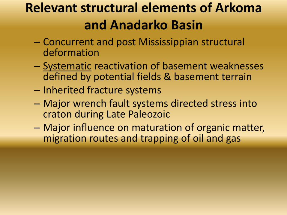
Relevant structural elements of Arkoma and Anadarko Basin
– Concurrent and post Mississippian structural deformation
– Systematic reactivation of basement weaknesses defined by potential fields & basement terrain
– Inherited fracture systems – Major wrench fault systems directed stress into
craton during Late Paleozoic – Major influence on maturation of organic matter,
migration routes and trapping of oil and gas

MLP in southern Kansas
Horizontal wells drilled since January 2011 Mississippian structure (450 ft C.I.) and notable faults (green lines)
Wellington Field
Central Kansas Uplift
Kansas
Oklahoma
20 miles
Sedgwick Basin
Spivey-Grabs
Aetna Field
http://maps.kgs.ku.edu/co2/

Structural contour map, top Proterozoic surface eastern Kansas and eastern Oklahoma • after Bill McBee (2003) •Contours in Kansas and Nebraska modified from Burchett et al. (1981) • Nemaha fault trace in Kansas adapted from Berendsen and Blair (1992).
http://www.searchanddiscovery.com/documents/2003/mcbee/images/mcbee.pdf
KGS-OGS Current #1, Pontotoc County, OK
Garber Uplift – large restraining bend along Nemaha U. Earthquake 2012 4th qtr
Historical earthquake activity, central OK
Wellington Field

Generalized fault framework of the area encompassing the Nemaha Uplift • En echelon, northwest-southeast surface faults east of the Nemaha zone in Oklahoma (Miser, 1954). - Transtensional • The Nemaha zone originated by strike-slip movements – right lateral • Trace of the Nemaha fault adapted from Berendsen and Blair (1992)
http://www.searchanddiscovery.com/documents/2003/mcbee/images/mcbee.pdf
Garber Uplift – large restraining bend along Nemaha U.
Choctow Fault Historical earthquakes, central OK -- En echelon west-east and N-S series of basement faults
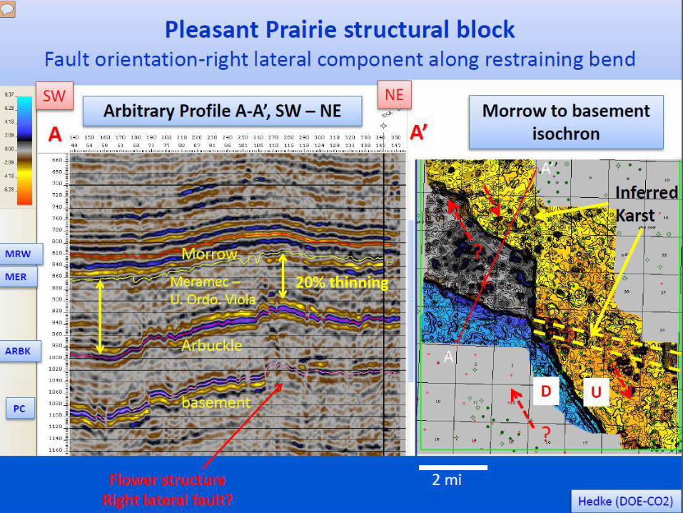
P-M cores Wellington
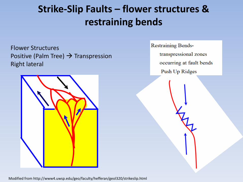
Strike-Slip Faults – flower structures & restraining bends
Flower Structures Positive (Palm Tree) Transpression Right lateral
Modified from http://www4.uwsp.edu/geo/faculty/hefferan/geol320/strikeslip.html


Wellingon Field PM Cores


Major NE-trending faults on the top of Mississippian overlying and on the flanks of the Nemaha Uplift & nearby W-E trending en echelon faults along east
side of the Nemaha Uplift
Suzanne Rogers, AAPG Bulletin, v. 85, no. 1 (January 2001), pp. 115–129
Approximate Meramec subcrop
Highway 60 chat trend

Seismic Section HW 60 Trend Shane Matson - “…evidence of extensive wrenched terrain” AAPG Mississippi Lime Forum, Jan. 31, 2013, Oklahoma City
• Fault zones as splays and resembling flower structures • Faulting greatly diminished in the overlying Desmoinesian strata with flatter dip
Top Mississippian

Dwight C. Bradley & David L. Leach (2002) Tectonic Controls of Mississippi Valley-Type Lead-Zinc Mineralization in Orogenic Forelands
Tectonic Elements in Ozark-Ouachita-Arkoma Basin Exert Strong Control On the Location and Development of the Pb-Zn Mineral Belt
Miami Trough
Seneca Fault
Chesapeake Fault
P-M cores
Mississippian Shelf
Mississippian Basin

SW-NE Core Transect of Mississippian Near Miami Trough Fault System –
Contemporaneous Faulting and Eustatic Controls
P-M cores
Ramaker et al. (2014)
Wellington Field
Miami Trough Mississippian
Embayment

Dolomitic bioclastic wackestone (lower Cowley facies)
Ramaker et al. (2014)
TST
HST
LST
PM-8
PM-21
PM-12
PM-17
Depositional Sequences and Complex Progradation -- Upper Meramec to Kinderhook age, Cowley Facies, Inner to Mid Ramp
11 mi (18 km)
50 ft (15 m)
Variable Chert Breccia
Tripolitic Chert
HST
Meramec
Osage
Kinderhook
Depositional sequences from Handford and Manger (1993)

PM SW-NE structural cross section 100 ft.
PM - 21 PM -12 PM - 8 PM -17
Middle Pennsylvanian Cherokee Group
PM Wells Episodically Active (Growth) Faulting
During Pennsylvanian and Mississippian
Pennsylvanian Cherokee Group
Mississippian
NW SE
Tebo Coal bed
D U
Offset on top of Mississippian ~100 ft
Horizontal length ~10 mi Vertical Exaggeration ~50 x

Magnetic – reduced to pole, overlain with configuration of Precambrian surface (Cole, 1976; Kruger, 1999)
Wellington Field ~18 mi west of the Nemaha Uplift
Regional DOE-CO2 study area ~25,000 mi2
Phanerozoic structures are largely derived by reactivation of basement weaknesses
-- MLP developed on southern rhyolite granite Proterozoic terrane cross-cut by the Midcontinent Rift System
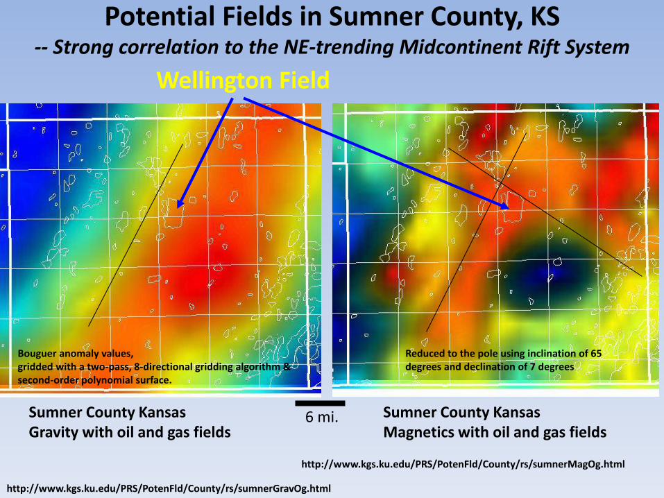
Sumner County Kansas Gravity with oil and gas fields
Sumner County Kansas Magnetics with oil and gas fields
Wellington Field
6 mi.
Potential Fields in Sumner County, KS -- Strong correlation to the NE-trending Midcontinent Rift System
http://www.kgs.ku.edu/PRS/PotenFld/County/rs/sumnerGravOg.html
http://www.kgs.ku.edu/PRS/PotenFld/County/rs/sumnerMagOg.html
Reduced to the pole using inclination of 65 degrees and declination of 7 degrees
Bouguer anomaly values, gridded with a two-pass, 8-directional gridding algorithm & second-order polynomial surface.

Third-order structural residual Top Mississippian
Sumner County, KS
6 mi
Wellington Field
(NE-SW trending structural high)
P. Gerlach, DOE-CO2
Nemaha Uplift
6 mi

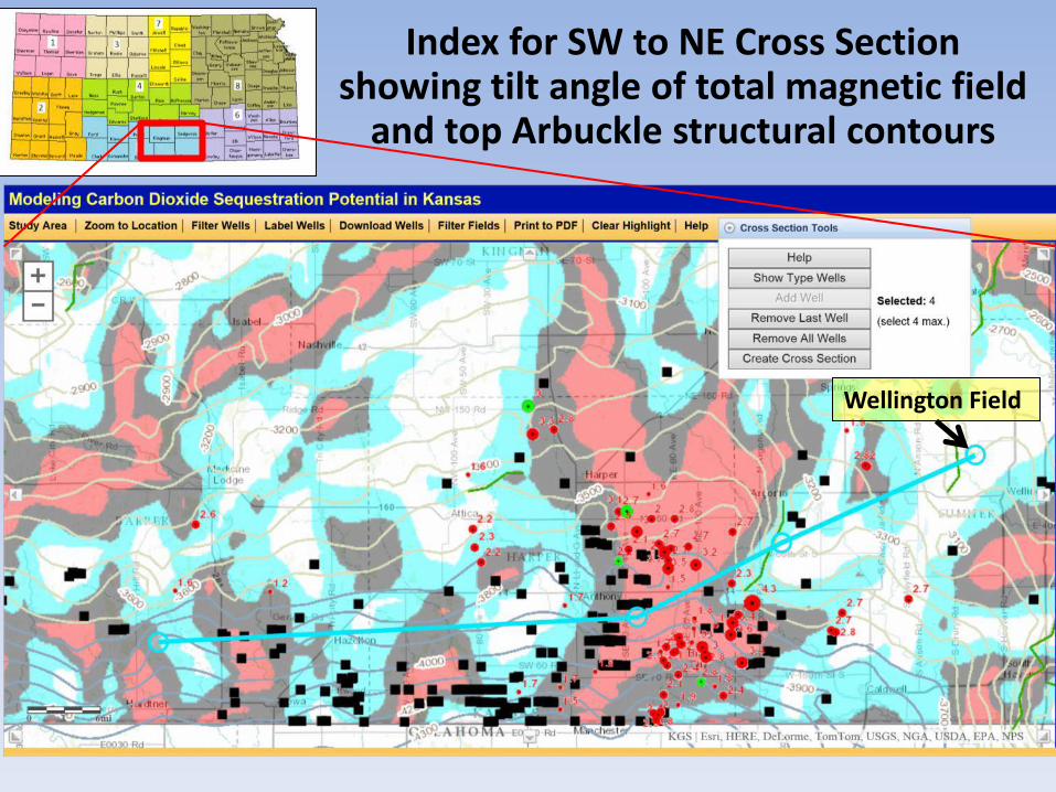
• Tilt angle total magnetic with top Mississippian structure
• Rust-colored dots are horizontal wells drilled since Jan. 2011
• Green circles – DOE digital type wells with correlated formation tops
• Purple squares – Arbuckle commercial-scale CO2 simulation sites
SW
NE
Berexco Wellington KGS #1-32
1
2 3
4
West side of cross section crosses major basement faults related to the Midcontinent Rift
M. Killion KGS
10 miles
http://maps.kgs.ku.edu/co2/
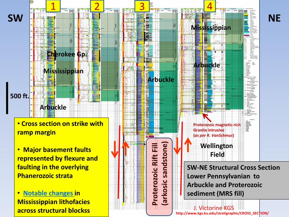
SW-NE Structural Cross Section Lower Pennsylvanian to Arbuckle and Proterozoic sediment (MRS fill)
500 ft.
Mississippian Arbuckle
Mississippian
Cherokee Gp.
Pro
tero
zoic
Rif
t Fi
ll (a
rko
sic
san
dst
on
e)
Proterozoic magnetic-rich Granite intrusive (as per R. VanSchmus)
1 2 3 4
Arbuckle
Arbuckle
J. Victorine KGS
Wellington Field
• Cross section on strike with ramp margin • Major basement faults represented by flexure and faulting in the overlying Phanerozoic strata • Notable changes in Mississippian lithofacies across structural blockss
SW NE
http://www.kgs.ku.edu/stratigraphic/CROSS_SECTION/

Updated horizontal wells ( ) and seismic events ( ) with tilt angle of total magnetic field
and top Arbuckle structure for Harper and Sumner County area
Harper Co.
Sumner Co.
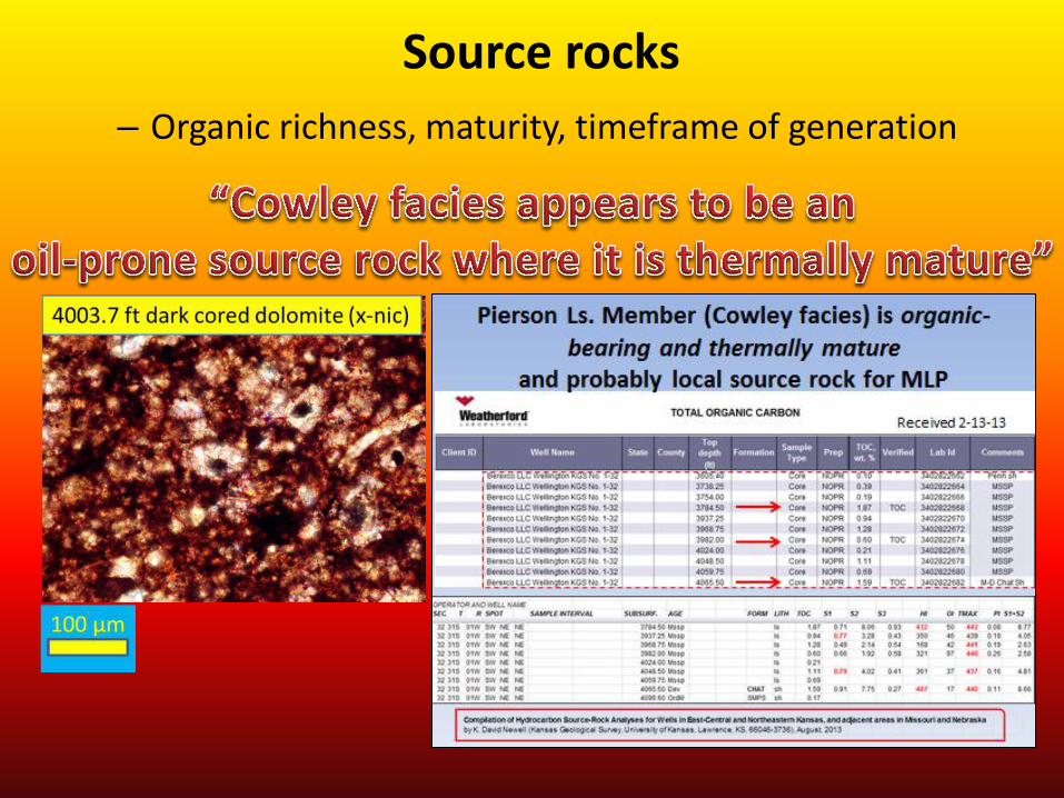
Source rocks
– Organic richness, maturity, timeframe of generation

Elevated thermal maturation along NE corner of Anadarko Basin
Transformation ratios (% TR) on the Woodford Shale layer from the four-dimensional petroleum system model
Gaswirth & Higley (2013)
• Simpson Group Oil Creek Formation layer source rocks (light green) started about 340 Ma. • Woodford Shale oil generation about 335 Ma • Thirteen Finger limestone (blue) about 300 Ma.
Mississippian-Woodford Trend

Higher gas-oil ratio in south-central and southwest Kansas
-- early oil migration followed by methane
Newell et al (1989)
Harper Co.
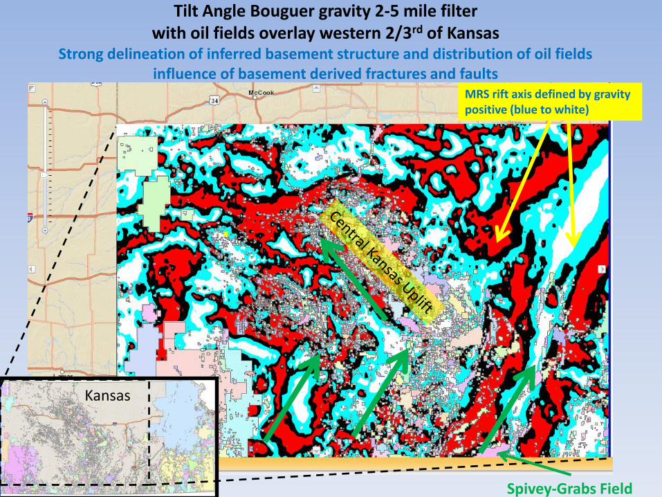
Tilt Angle Bouguer gravity 2-5 mile filter with oil fields overlay western 2/3rd of Kansas
Strong delineation of inferred basement structure and distribution of oil fields influence of basement derived fractures and faults
MRS rift axis defined by gravity positive (blue to white)
Kansas
Spivey-Grabs Field
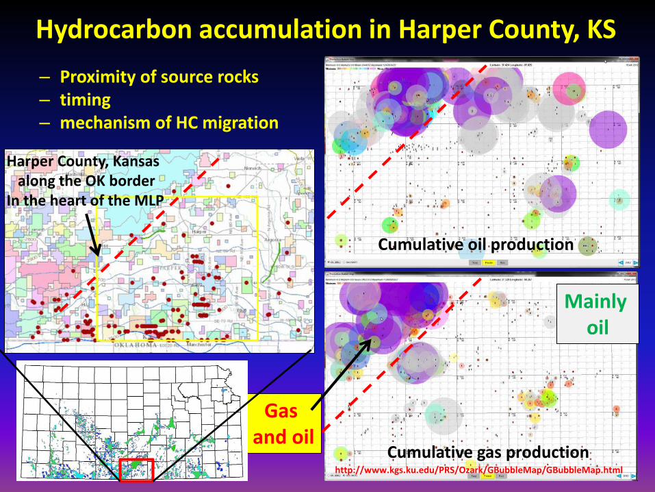
Hydrocarbon accumulation in Harper County, KS
– Proximity of source rocks – timing – mechanism of HC migration
Cumulative gas production
Cumulative oil production
Harper County, Kansas along the OK border In the heart of the MLP
http://www.kgs.ku.edu/PRS/Ozark/GBubbleMap/GBubbleMap.html
Gas and oil
Mainly oil

• Conventional reservoir
– deposition, diagenesis, and structural modification
– hydrocarbon accumulation controlled by capillary pressure (matrix), hydrocarbon column, relative permeability, fracture aperture and spacing
– reservoir pressure and reservoir energy…
• Unconventional reservoir lithofacies –
– argillaceous dolomitic cherty argillaceous siltstones
– tight rocks (fractured?) interbedded with porous nodular chert and spiculite
– organic-bearing serving as own source rock (regional thermal and local elevated heat flow)
Spectrum of lithofacies and quality reservoir rock
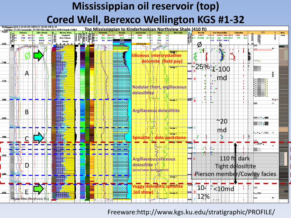
Spiculite - dolo-packstone-
Argillaceous siliceous dolosiltite (pico/nano darcy perm)
Vuggy dolomitic spiculite (oil show)
Argillaceous dolosilitite
Nodular chert, argillaceous dolosilitite
Siliceous intercrystalline dolomite (field pay)
Mississippian oil reservoir (top) Cored Well, Berexco Wellington KGS #1-32
Top Mississippian to Kinderhookian Northview Shale (410 ft)
A
B
C
D
E Base Miss. (Northview Sh.)
Top Miss.
T
T
T
T T
T
R
R
R
R
R
R
T
R
R
Trans.
Trans.
Trans. Trans.
Trans.
Trans.
Trans.
1-100
md
~25%
Ø k
Freeware:http://www.kgs.ku.edu/stratigraphic/PROFILE/
110 ft. dark Tight dolosiltite
Pierson member/Cowley facies
Ø
<10md 10- 12%
~20 md

High lateral variation in apparent reservoir quality and thickness Upper cherty intercrystalline dolomite reservoir (main pay at top)
Wellington Field, Sumner County, KS
Amplitude envelope map of the Mississippian reflection
Instantaneous frequency map of the Mississippian reflection
#1-32 #1-32
#1-28 #1-28
Can we relate real data seismic amplitude and frequency to reservoir thickness as it has been suggested by the modeling?
Ayrat Sirazhiev, M.S. Geology, 2012
2

Porosity Model (log/3D seismic) of the Siliceous Dolomite Reservoir
Upper Mississippian, Wellington Field
Porosity inversion of the 3D Seismic Wellington Field
Complex offlapping geometries of porous lithofacies resulting from the westward progradation of the Mississippian -- Looking SW
J. Rush, KGS
0.02
0.25
KGS 1-32
KGS 1-28

• View looks to the northeast • Fault juxtaposes reservoir and non reservoir facies (at arrow tip) • Fault offset ~30 ft • Faults serve as potential barriers to flow or redirect CO2 plume depending on
fault damage and juxtaposed rocks • Faults aligned perpendicular to maximum horizontal compressive stress
J. Rush, KGS
Faults with small offset & continuity of permeable rock
Permeability fence diagram of Mississippian oil reservoir within 3D seismic, Wellington Field
--Small faults that tip out above the top of the Mississippian reservoir

CO2 plume from latest simulation of Mississippian pilot injection (26,300 tonnes)
-- modeled CO2 sweep defined contact defined by complex lithofacies distribution and faulting
E. Holubnayak, KGS
New injection well to be drilled -- Wellington KGS #2-32
Elongate N-S CO2 plume influenced by newly mapped N-NE trending faults acting as both barriers and conduits for CO2

KGS #1-32 Wellington : Estimation of permeability based on magnetic resonance imaging (MRILtm) using porosity and T2 center-of-gravity versus core Kmax, K90, and Kvert core permeabilities
Doveton & Fazelalavi, July 2012
120 ft (37 m) low k, argillaceous dolosiltite TOC ~2% (caprock, seal)
Oil Pay
Wet
Oil Show
Sw = 60%
Permeability profile entire Mississippian

Lowermost porosity in KGS Wellington #1-32-- dolomitic spiculite (in situ biostromal accumulation) in lower Cowley facies with oil show

Wellington 4029.73 ft (Cowley facies) deep-water, porous and permeable dolospiculite (oil bearing)

Oil column in typical conventional reservoirs requires ~75 ft to approach irreducible water saturation and zero water cut based
on capillary pressure curves for common Mississippian reservoirs in MLP
M. Fazelalavi (KGS)
Mercury injection capillary pressure curves are calculated by TecLog™ using NMR data -- compared to Osage dolomite reservoir at Schaben Fld., Ness Co. from Dubois et al. (2003)
Approaching irreducible Sw

“High bound water saturations in the tripolitic chert have led to difficulty in estimating reserves and determining producible zones. This problem in water saturations is further complicated by difficulty in establishing free water level. While some fields exhibit apparent structural closure greater than 200 feet, the presence of nearly isolated blocks of production within these fields surrounded by nonproductive areas may indicate that there is not a continuous hydrocarbon column and that free water level is independently established for each block”. -- Watney, Guy, Byrnes (2001) horizontal wells anyone?
Triopolite Glick Field Kiowa County, KS
Krw/Kro ratio ~ water cut

50 ft
“Cowley facies” in SW to NE Cross Section -- Berexco Wellington KGS #1-32 (left) & #1-28 (right)
(3000 ft distance between wells)
Erosional base
“Cowley facies”
Chattanooga Sh.
Simpson Gp.
Arbuckle Gp.
Cross Section Java Appet – J. Victorine, KGS, DOE-CO2 Correlations – regional team (Bittersweet ), DOE-CO2
http://www.kgs.ku.edu/stratigraphic/CROSS_SECTION/
Received 2-13-13
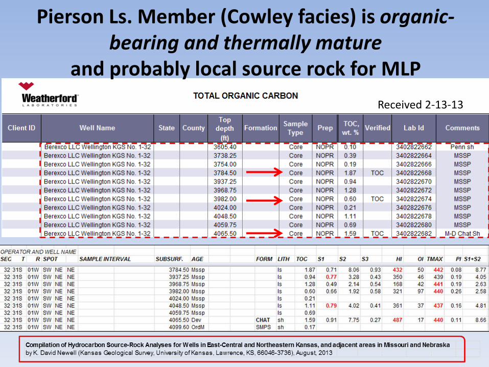
Pierson Ls. Member (Cowley facies) is organic-bearing and thermally mature
and probably local source rock for MLP

Helical CT scan of
3968.1 to 3971.1 ft
3968.75 ft (1.28% total
organic carbon)
TMAX = 441
S1 = 0.49 up to .91
HI 168 up to 432
Local HC maturation of “Cowley facies” and Woodford/Chattanooga - Potential for charging along
fractures - Displace water - Increasing oil cut - Locally, continuous HC column???

Organic bearing dolosiltite lower Mississippian, Wellington Field
Wellington Field
Index for SW to NE Cross Section showing tilt angle of total magnetic field
and top Arbuckle structural contours

200 ft
SWD well Harper Co.
Boggs SW Field Barber Co. (gas, P&A)
D&A Sumner Co.
75’SOCM & GO
Oil
Wellington KGS #1-28 Sumner Co.
40’ mud
argillaceous “Cowley facies”
Cowley
Compton & Northview
Compton & Northview
Complex lithologic changes in Mississippian Reservoir
Datum = sealevel Total length of section ~75 mi
No horizontal scale Index map on previous page
Cross section Java applet, J. Victorine, DOE-CO2
Gas, P&A
Arbuckle
Simpson Chattanooga Shale
Chattanooga Shale Chattanooga Shale
Mississippian
NE SW

• Prograding and downlapping Osage and Meramec strata along ramp • Variable pore types along the lateral • Not simple oil:water contact • ~135 ft of oil column • Reservoir pressure, drive? • Locally charged with thermally mature, underlying Woodford Shale or “Cowley facies”? • Fractures? Water or oil? • How was well completed?
Core to Characterization and Modeling
of the Mississippian, North Alva Area,
Woods and Alfalfa Counties, Oklahoma Dan Costello1, Martin Dubois2, and Ryan Dayton1
1 Chesapeake Energy Corporation
2 Improved Hydrocarbon Recovery, LLC
2014 Mid-Continent Section AAPG Core Workshop
~13
5 f
t o
il co
lum
n
South North
Factors in water cut?

Summary
• Mississippi Lime Play (complex)
• Structural history of Arkoma and Anadarko Basin (complex)
• Source rocks (several)
• Hydrocarbon migration (regional and local)
• Spectrum of lithofacies and reservoir quality (Yes!)
• Unconventional reservoir (locally)
• Why variations in water cut?
(many and varied possibilities)
KSCO2

Q&A with Lynn Watney, Kansas Geological Survey

Help Us Help You!
CLICK HERE
(A new browser window will open)
Please give us your feedback and suggestions


