Page 1
1
NeoStencil – Live Online Classes - IAS/IES/GATE/SSC/PSC | +91 95990 75552 | [email protected]
Fluvial Erosional Landforms
In geography, fluvial processes are associated with movement and energy
associated with rivers and streams, and landforms created by them. Landforms
are small to medium tracts or parcels of the earth’s surface.
There are two types of landforms created by the fluvial process
1. Fluvial Erosional Landforms
2. Fluvial Depositional Landforms
The removal and transport of sediment due to fluvial processes result in erosional
landforms. In this article, we will discuss erosional landforms of Fluvial Process.
Fluvial Erosional Landforms
Unlike other geomorphic agents like wind and ice etc., which are confined to
certain areas, the effect of running water is felt all over the globe wherever water
is present. Thus running water forms the most potent geomorphic agent for
denuding the Earth’s surface through erosion.
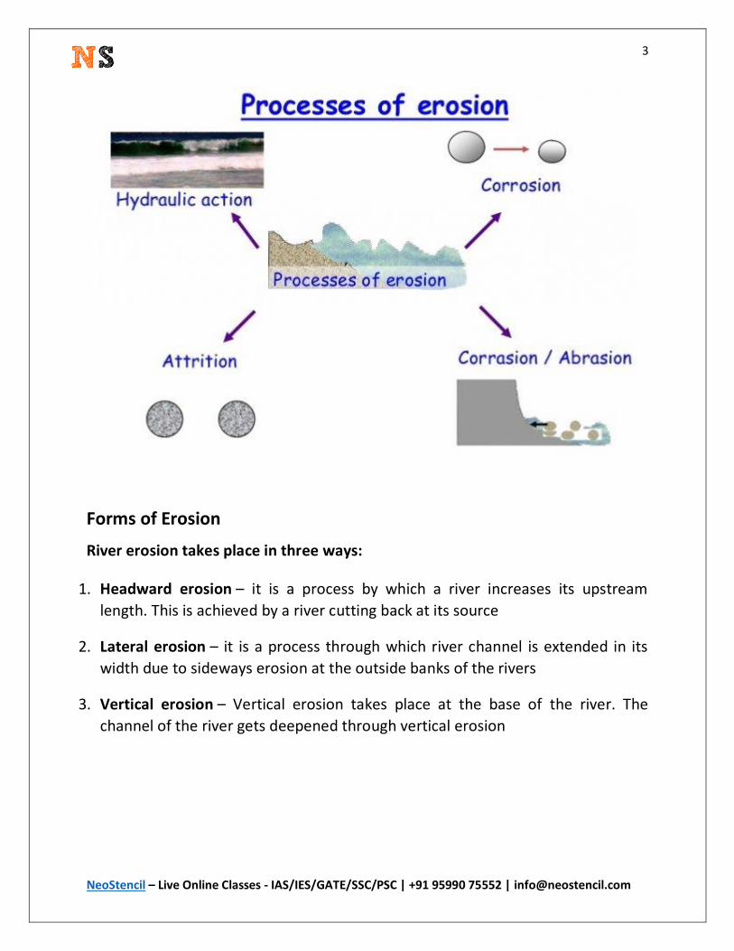
Different aspects of Fluvial Erosive Action
In rivers, erosion and transportation go on simultaneously. There are different
ways in which fluvial erosion takes place, such as:-
Corrasion or abrasion – Corrasion is a process of mechanical erosion of the
earth’s surface caused by mechanical grinding of the river’s traction load (coarser
material) against the bed and banks of the river. There are two distinct ways in
which Corrasion can take place:
1. Lateral Corrasion – Lateral Corrasion takes place sideways and widens the V-
shaped valley
Page 2
2
NeoStencil – Live Online Classes - IAS/IES/GATE/SSC/PSC | +91 95990 75552 | [email protected]
2. Vertical Corrasion – it is the downward action. It deepens the river channel
Hydraulic action – It is a mechanical process, in which the moving water current
flows against the banks and bed of a river, thereby removing rock particles. Some
of the water splashes against the river banks and surges into cracks and crevices.
This helps to disintegrate the rocks. The river water picks up the loose fragments
from its banks and bed and transports them away.
Attrition – this is a form of fluvial erosion in which the bed load is eroded by itself
due to wear and tear of the transported material when they roll and collide into
one another. The coarser boulders are broken down into smaller stones and
pebbles.
Corrosion or solution – this is the chemical or solvent action of water on soluble
or partly-soluble rocks with which the river comes into contact. For example,
calcium carbonate in limestone is easily dissolved and removed in solution.
While the first three processes of fluvial erosion come under mechanical erosion,
the last or the fourth process i.e. corrosion comes under chemical erosion by
fluvial action.
Page 3
3
NeoStencil – Live Online Classes - IAS/IES/GATE/SSC/PSC | +91 95990 75552 | [email protected]
Forms of Erosion
River erosion takes place in three ways:
1. Headward erosion – it is a process by which a river increases its upstream
length. This is achieved by a river cutting back at its source
2. Lateral erosion – it is a process through which river channel is extended in its
width due to sideways erosion at the outside banks of the rivers
3. Vertical erosion – Vertical erosion takes place at the base of the river. The
channel of the river gets deepened through vertical erosion
Page 4
4
NeoStencil – Live Online Classes - IAS/IES/GATE/SSC/PSC | +91 95990 75552 | [email protected]
The fluvial cycle of erosion
Three distinct stages of youth, maturity and old age can be identified during the
lifetime of a stream. At different stages of the erosional cycle, the valley acquires
different profiles. The characteristics related to each stage of landscape
development in running water regimes are summarised as below:
Youth
Streams are few during this stage with poor integration and flow over original
slopes
The valley developed is thus deep, narrow and distinctly V-shaped with no
floodplains or with very narrow floodplains.
Downcutting predominates over lateral corrasion
Streams divides are broad and flat with marshes, swamp and lakes.
Some of the outstanding features which are developed in this stage are gorges,
canyons waterfalls, rapids and river capture etc.
Mature
During this stage, streams are plenty with good integration.
Page 5
5
NeoStencil – Live Online Classes - IAS/IES/GATE/SSC/PSC | +91 95990 75552 | [email protected]
Lateral corrasion tends to replace vertical corrasion
The valleys are still V-shaped but wide and deep due to an active erosion of the
banks;
Trunk streams are broad enough to have wider floodplains within which
streams may flow in meanders confined within the valley.
Swamps and marshes of youth stage, as well as flat and broad inter-stream
areas, disappear. The stream divides turn sharp.
Waterfalls and rapids disappear.
Meander and slip off slopes are the characteristic features of this stage
Old
The river moving downstream across a broad level plain is heavy with
sediments.
Vertical corrasion almost ceases in this stage though lateral corrasion still goes
on to erode its banks further
Smaller tributaries during old age are few with gentle gradients.
Streams meander freely over vast floodplains. Divides are broad and flat with
lakes, swamps and marshes.
Depositional features predominate in this stage
Most of the landscape is at or slightly above sea level
Characteristic features of this stage are floodplains, oxbow lakes, natural levees
and Delta etc.
Fluvial Erosional Landforms
Most of the erosional landforms associated with running water are made by
youthful rivers vigorously flowing over steep gradients. With time, stream
channels over steep gradients turn gentler due to continued erosion, and as a
consequence, lose their velocity, facilitating active deposition. There are two
Page 6
6
NeoStencil – Live Online Classes - IAS/IES/GATE/SSC/PSC | +91 95990 75552 | [email protected]
components of running water. One is the sheet that refers to overland flow on
the land surface. Another is streams and rivers that refer to linear flow as in
valleys.
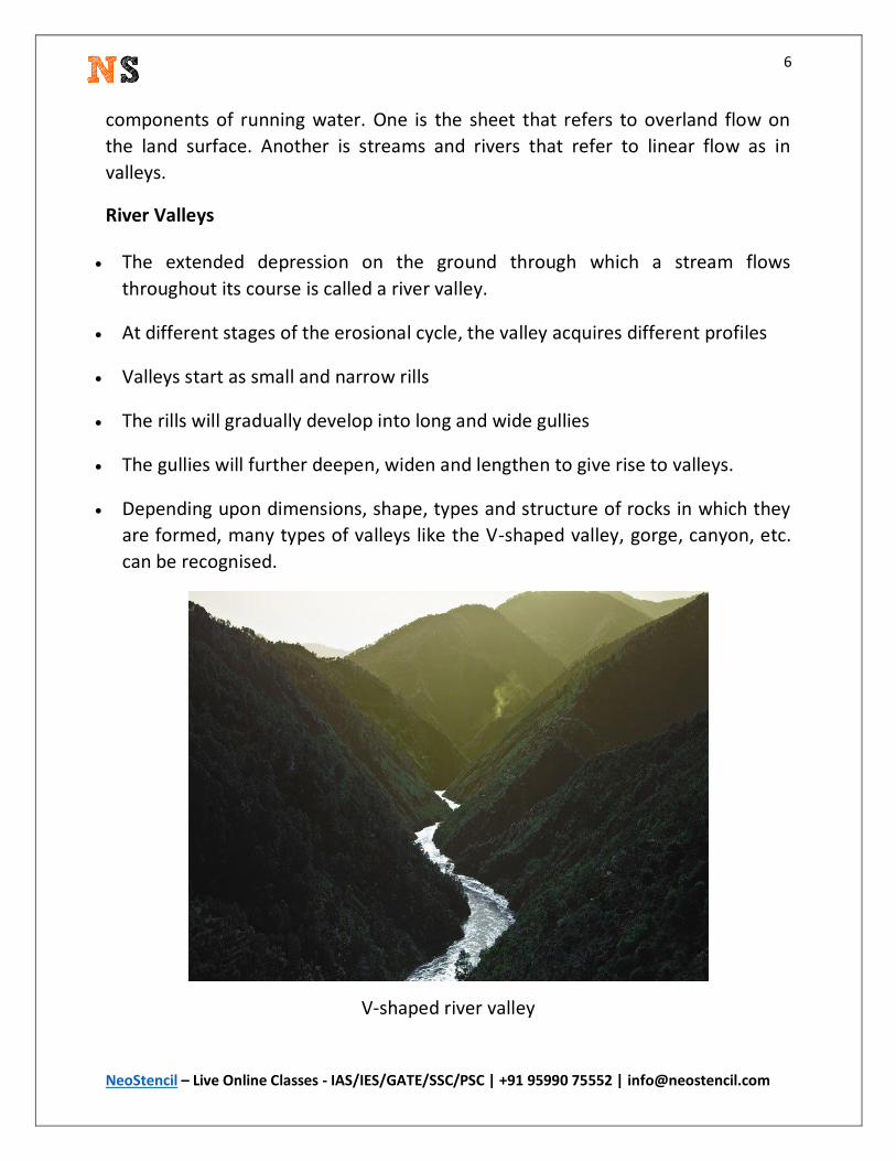
River Valleys
The extended depression on the ground through which a stream flows
throughout its course is called a river valley.
At different stages of the erosional cycle, the valley acquires different profiles
Valleys start as small and narrow rills
The rills will gradually develop into long and wide gullies
The gullies will further deepen, widen and lengthen to give rise to valleys.
Depending upon dimensions, shape, types and structure of rocks in which they
are formed, many types of valleys like the V-shaped valley, gorge, canyon, etc.
can be recognised.
V-shaped river valley
Page 7
7
NeoStencil – Live Online Classes - IAS/IES/GATE/SSC/PSC | +91 95990 75552 | [email protected]
1) V-shaped Valley
The river is very swift as it descends the steep slope, and the predominant
action of the river is vertical corrasion
The valley developed is thus deep, narrow and distinctly V-shaped
Formation of the V-shaped valley
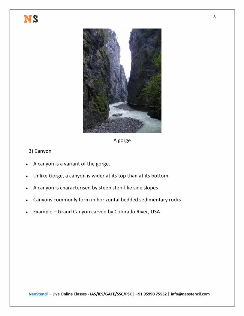
2) Gorge
A gorge is a deep and narrow valley with very steep to straight sides
A gorge is almost equal in width at its top as well as its bottom.
Gorges are formed in hard rocks.
Example – Indus Gorge in Kashmir
Page 8
8
NeoStencil – Live Online Classes - IAS/IES/GATE/SSC/PSC | +91 95990 75552 | [email protected]
A gorge
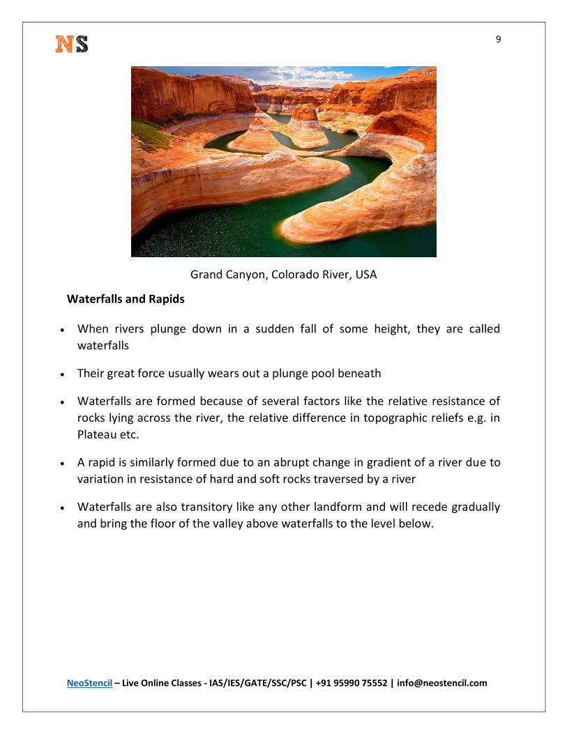
3) Canyon
A canyon is a variant of the gorge.
Unlike Gorge, a canyon is wider at its top than at its bottom.
A canyon is characterised by steep step-like side slopes
Canyons commonly form in horizontal bedded sedimentary rocks
Example – Grand Canyon carved by Colorado River, USA
Page 9
9
NeoStencil – Live Online Classes - IAS/IES/GATE/SSC/PSC | +91 95990 75552 | [email protected]
Grand Canyon, Colorado River, USA
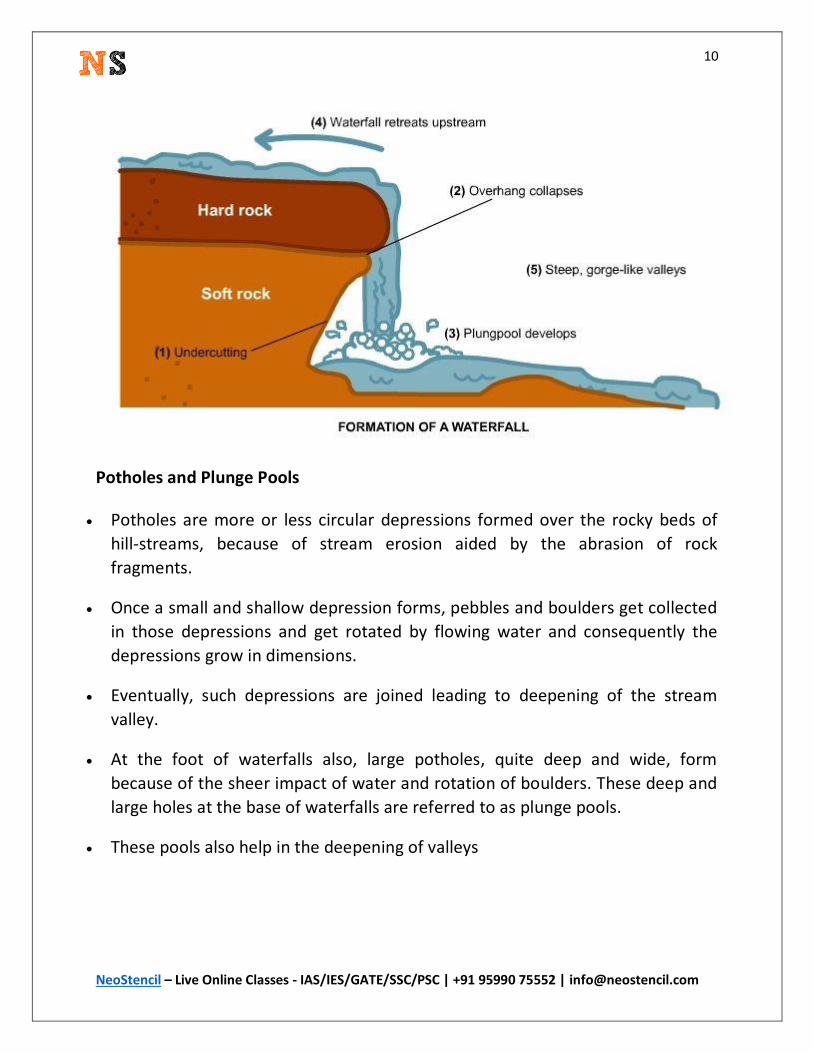
Waterfalls and Rapids
When rivers plunge down in a sudden fall of some height, they are called
waterfalls
Their great force usually wears out a plunge pool beneath
Waterfalls are formed because of several factors like the relative resistance of
rocks lying across the river, the relative difference in topographic reliefs e.g. in
Plateau etc.
A rapid is similarly formed due to an abrupt change in gradient of a river due to
variation in resistance of hard and soft rocks traversed by a river
Waterfalls are also transitory like any other landform and will recede gradually
and bring the floor of the valley above waterfalls to the level below.
Page 10
10
NeoStencil – Live Online Classes - IAS/IES/GATE/SSC/PSC | +91 95990 75552 | [email protected]
Potholes and Plunge Pools
Potholes are more or less circular depressions formed over the rocky beds of
hill-streams, because of stream erosion aided by the abrasion of rock
fragments.
Once a small and shallow depression forms, pebbles and boulders get collected
in those depressions and get rotated by flowing water and consequently the
depressions grow in dimensions.
Eventually, such depressions are joined leading to deepening of the stream
valley.
At the foot of waterfalls also, large potholes, quite deep and wide, form
because of the sheer impact of water and rotation of boulders. These deep and
large holes at the base of waterfalls are referred to as plunge pools.
These pools also help in the deepening of valleys
Page 11
11
NeoStencil – Live Online Classes - IAS/IES/GATE/SSC/PSC | +91 95990 75552 | [email protected]
Incised or Entrenched Meanders
Incised or entrenched meanders are found cut in hard rocks. They are very deep
and wide.
In streams that flow rapidly over steep gradients, normally erosion is
concentrated on the bottom of the stream channel.
Entrenched meander normally occurs where there is a rapid cutting of the river
bed such that the river does not get to erode the lateral sides.
Meander loops are developed over original gentle surfaces in the initial stages
of development of streams and the same loops get entrenched into the rocks
normally due to erosion or gradual uplift of the land over which they started.
Page 12
12
NeoStencil – Live Online Classes - IAS/IES/GATE/SSC/PSC | +91 95990 75552 | [email protected]
They are widened and deepened over a long period of time and can be found as
deep gorges and canyons in the areas where hard rocks are found.
They give an indication of the status of original land surfaces over which
streams have developed.
Incised meanders are said to be an impact of river rejuvenation.
River Terraces
River terraces refer to surfaces relating to old valley floor or floodplain levels.
They may be bedrock surfaces without any alluvial cover or alluvial terraces
consisting of stream deposits.
River terraces are basically products of erosion as they result due to vertical
erosion by the stream into its own depositional floodplain.
There can be a number of such terraces. They are found at different heights
indicating former river bed levels.
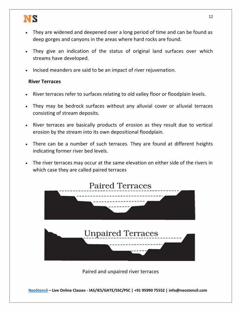
The river terraces may occur at the same elevation on either side of the rivers in
which case they are called paired terraces
Paired and unpaired river terraces
Page 13
13
NeoStencil – Live Online Classes - IAS/IES/GATE/SSC/PSC | +91 95990 75552 | [email protected]
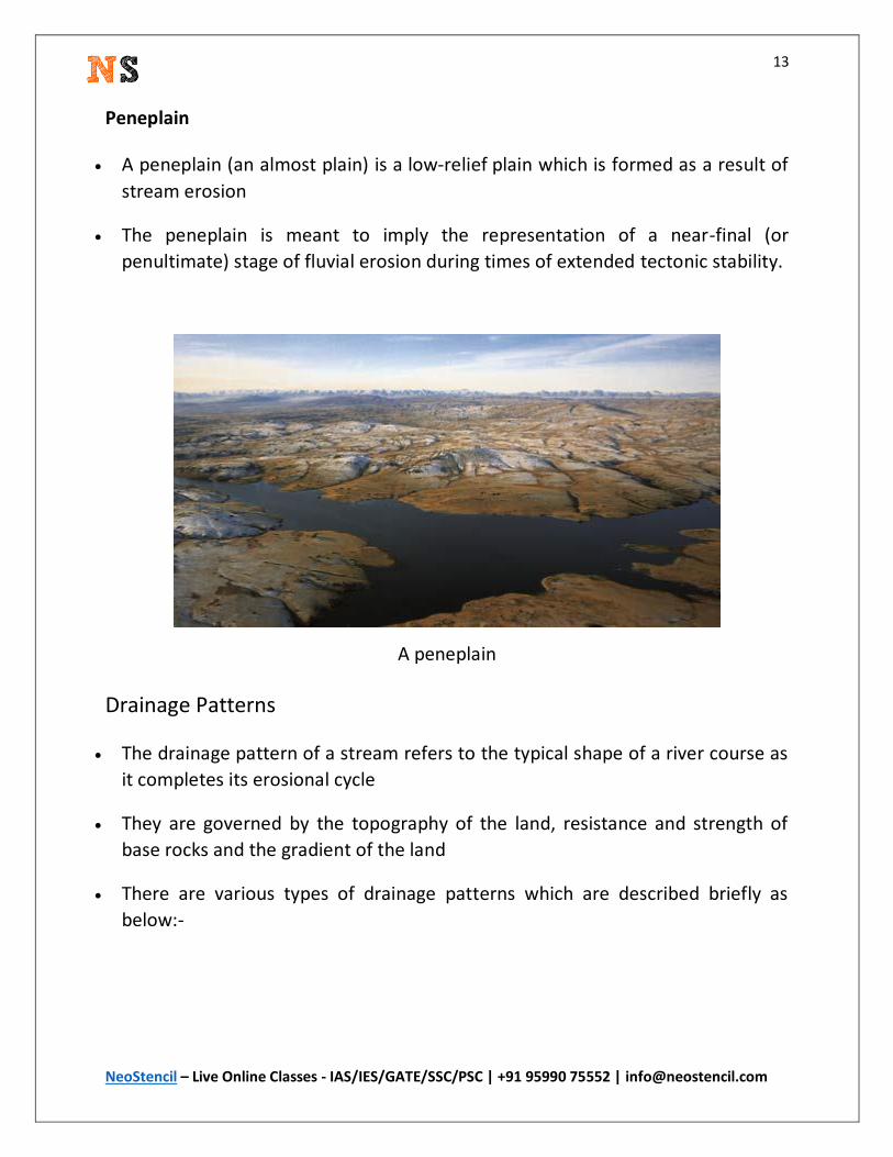
Peneplain
A peneplain (an almost plain) is a low-relief plain which is formed as a result of
stream erosion
The peneplain is meant to imply the representation of a near-final (or
penultimate) stage of fluvial erosion during times of extended tectonic stability.
A peneplain
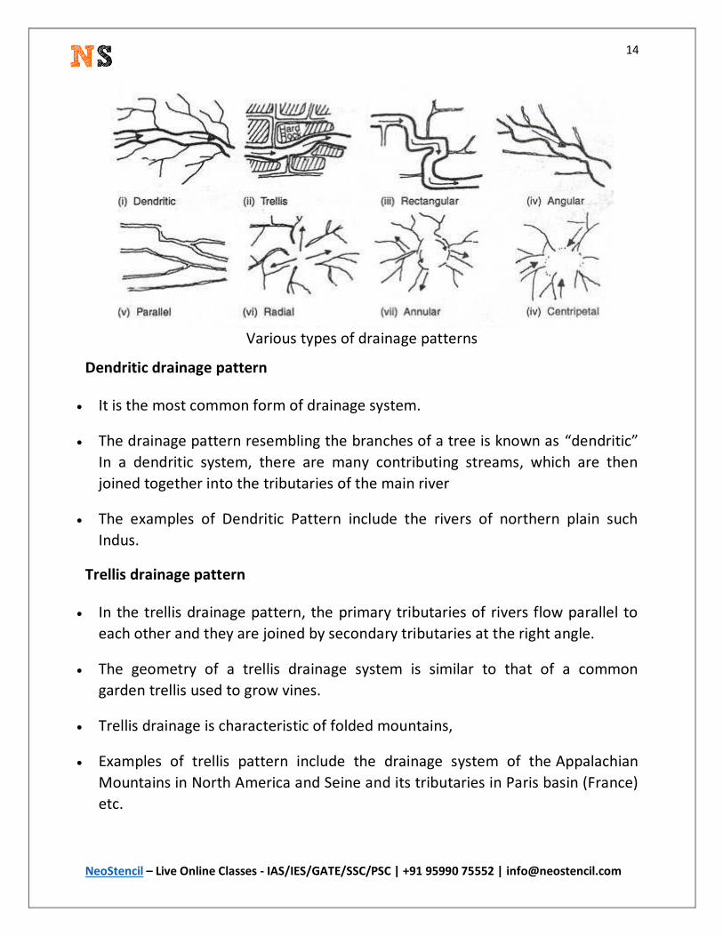
Drainage Patterns
The drainage pattern of a stream refers to the typical shape of a river course as
it completes its erosional cycle
They are governed by the topography of the land, resistance and strength of
base rocks and the gradient of the land
There are various types of drainage patterns which are described briefly as
below:-
Page 14
14
NeoStencil – Live Online Classes - IAS/IES/GATE/SSC/PSC | +91 95990 75552 | [email protected]
Various types of drainage patterns
Dendritic drainage pattern
It is the most common form of drainage system.
The drainage pattern resembling the branches of a tree is known as “dendritic”
In a dendritic system, there are many contributing streams, which are then
joined together into the tributaries of the main river
The examples of Dendritic Pattern include the rivers of northern plain such
Indus.
Trellis drainage pattern
In the trellis drainage pattern, the primary tributaries of rivers flow parallel to
each other and they are joined by secondary tributaries at the right angle.
The geometry of a trellis drainage system is similar to that of a common
garden trellis used to grow vines.
Trellis drainage is characteristic of folded mountains,
Examples of trellis pattern include the drainage system of the Appalachian
Mountains in North America and Seine and its tributaries in Paris basin (France)
etc.
Page 15
15
NeoStencil – Live Online Classes - IAS/IES/GATE/SSC/PSC | +91 95990 75552 | [email protected]
Parallel drainage pattern
A parallel drainage system is a pattern of rivers caused by steep slopes with
some relief.
The parallel drainage pattern is observed in a uniformly sloping region where
the tributaries seem to be running parallel to each other.
A parallel pattern sometimes indicates the presence of a major fault that cuts
across an area of steeply folded bedrock.
Examples of this system include the rivers of Lesser Himalaya
Rectangular drainage pattern
Rectangular drainage develops on rocks that are of approximately uniform
resistance to erosion, but which have two directions of joining at approximately
right angles.
In the rectangular drainage pattern, the mainstream curve at right angles and
the tributaries join the mainstream at right angles.
Example – Colorado river the USA
Angular drainage pattern
Angular drainage pattern is commonly observed in foothill regions.
Angular drainage patterns form where bedrock joints and faults intersect at
more acute angles than rectangular drainage patterns. Angles are both more
and less than 90 degrees
the mainstream is joined by the tributaries at acute angles.
Radial drainage pattern
When the rivers originate from a hill and flow in all directions, the drainage
pattern is known as ‘radial’.
Page 16
16
NeoStencil – Live Online Classes - IAS/IES/GATE/SSC/PSC | +91 95990 75552 | [email protected]
Volcanoes usually display excellent radial drainage. Other geological features on
which radial drainage commonly develops are domes and laccoliths.
The rivers originating from the Amarkantak range present a good example of it.
Centripetal drainage pattern
When the rivers discharge their waters from all directions in a lake or
depression, the pattern is known as ‘centripetal’.
Examples – streams of Ladakh, Tibet and Loktak Lake in Manipur (India)
Annular drainage pattern
In an annular drainage pattern streams follow a roughly circular or concentric
path along a belt of weak rock, resembling in plan a ring-like pattern.
Example of such system include Black Hill streams of South Dakota, USA
Page 17
17
NeoStencil – Live Online Classes - IAS/IES/GATE/SSC/PSC | +91 95990 75552 | [email protected]
Study from India’s Best IAS Teachers LIVE Online
NeoStencil is India's number 1 platform for LIVE online learning. We help you connect with India's best teachers from the comfort of your home.
Some of our popular UPSC Civil Services Exam courses:
UPSC General Studies Foundation Courses offered at NeoStencil
1. Lukmaan IAS 2. Pavan Kumar IAS 3. Destination IAS 4. Toppers 25
UPSC Mains Optional Subjects courses
Pub Ad :S. Ansari, Pavan Kumar, Atul Lohiya (Hindi Medium) Philosophy :Mitrapal Geography :Prof. Majid Husain, Alok Ranjan (English and Hindi Medium), Md. Rizwan Sociology :Praveen Kishore, Vikash RanjanVenkata Mohan, Mujtaba Husain Anthro :Venkata Mohan History :Alok Jha PSIR : Kailash Mishra (English and Hindi Medium), RS. Sharma Law : Dinesh Verma (Scope IAS)
General Studies Mains Test Series:Pavan Kumar IAS, Lukmaan IAS, AAI IAS Pub Ad Test Series :Pavan Kumar Sociology Test Series :Praveen Kishore, Venkata Mohan, Lukmaan IAS Geography Test Series :Prof. Majid Husain, Alok Ranjan (English and Hindi) , Lukmaan IAS Anthro Test Series :Venkata Mohan Essay Test Series :Lukmaan IAS, Venkata Mohan
Current Affairs Online Courses for IAS Exam Preparation
1. Lukmaan IAS 2. Venkata Mohan 3. Mk Yadav 4. Alok Jha
We also Provide Online courses for IES | GATE | SSC | State PCS Exams. For more details visit
our All Courses Page – here