Fluvial landforms and their implication towards understanding the past climate and seismicity in the northern Katrol Hill Range, western India Falguni Bhattacharya a, * , B.K. Rastogi a , M.G. Thakkar b , R.C. Patel c , Navin Juyal d a Institute of Seismological Research, Raisan, Gandhinagar 382009, Gujarat, India b Department of Earth and Environmental Science, K.S.K.V. Kachchh University, Bhuj Kachchh 370001, India c Department of Geophysics, Kurukshetra University, 136118, India d Geoscience Division, Physical Research Laboratory, Navrangpura, Ahmedabad 380009, India article info Article history: Available online xxx Keywords: Kachchh Optical dating Valley-fill Palaeoclimate Paleoseismicity abstract The tectonically active Kachchh peninsula in western India lies in the southwest monsoon trajectory and hence provides a rare opportunity to decipher the temporal changes in climateetectonics interaction in the evolution of the fluvial landforms. Reconstructions based on geomorphology, sedimentology, and geochemistry supported by optical chronology suggest that the fluvial aggradation in the region was initiated during the onset of the Indian Summer Monsoon (ISM) after the Last Glacial Maximum (LGM). The sedimentary characteristics and major elemental concentrations suggest that the sediments are dominated by fluvially reworked miliolites with subordinate contribution from the Mesozoic sandstones and shales and were deposited with the initiation of the ISM after the LGM. Temporal changes in facies architecture and major element concentrations suggest a progressive strengthening of the monsoon between 17 and 12 ka. This was succeeded by an overall strengthened ISM phase with fluctuations after 12 ka and <8 ka. Following this, a gradual decline in the ISM is inferred until around 3 ka. However, presence of the younger valley-fill sediments which are dated to w1 ka are ascribed to a short-lived phase of renewed strengthened ISM in the region before the onset of present day aridity. Based on the morphology of the fluvial landforms, two major events of enhanced uplift can be sug- gested. The geomorphic expression of the older uplift event dated to >17 ka is represented by the beveled Mesozoic bedrock surfaces which accommodated the post LGM valley-fill aggradation. The younger event of enhanced uplift which is assigned to <3 ka was responsible for the incision of the fill sediments and the Mesozoic bedrock, and the evolution of the present day fluvial landforms. The time averaged incision/uplift rate indicates that the Katrol Hill Range is uplifting at the rate of w4 mm per year, implying seismically active terrain. Ó 2014 Elsevier Ltd and INQUA. All rights reserved. 1. Introduction In actively uplifting areas, rivers are dominantly involved in incising the underlying resistant bedrock (Whipple, 2004). There- fore, such rivers lack laterally continuous alluvium cover: instead, discrete sedimentary patches can be found along their courses (Howard et al., 1994). In seismically active and monsoon dominated regions, studies suggest that on millennial time scales, the rivers oscillate between incision and valley aggradation. This is ascribed to the changes in monsoon intensity and sediment flux (Pratt- Sitaula et al., 2004). In view of this, the morphology and sedi- mentary successions of the rivers can be used to reconstruct the history of enhanced uplift and climate variability. The Kachchh peninsula in western India is one such region where the interplay between climate and tectonics can be dis- cerned through the fluvial successions which is preserved in various bedrock river valleys. Presently, all the major rivers in the Kachchh peninsula are actively incising the Mesozoic, Palaeogene, and Neogene bedrock (Thakkar et al., 1999; Maurya et al., 2003; Patidar et al., 2007, 2008; Bhattacharya et al., 2013). However, the presence of valley and channel-fill deposits of varying thicknesses preserved in different river valleys suggests that there were periods of tectonic stability in the geological past (Mathew et al., 2006; Patidar et al., 2007). Further, the temporal changes in the pattern * Corresponding author. E-mail address: [email protected](F. Bhattacharya). Contents lists available at ScienceDirect Quaternary International journal homepage: www.elsevier.com/locate/quaint http://dx.doi.org/10.1016/j.quaint.2014.03.002 1040-6182/Ó 2014 Elsevier Ltd and INQUA. All rights reserved. Quaternary International xxx (2014) 1e13 Please cite this article in press as: Bhattacharya, F., et al., Fluvial landforms and their implication towards understanding the past climate and seismicity in the northern Katrol Hill Range, western India, Quaternary International (2014), http://dx.doi.org/10.1016/j.quaint.2014.03.002
Transcript
lable at ScienceDirect
Quaternary International xxx (2014) 1e13
Contents lists avai
Quaternary International
journal homepage: www.elsevier .com/locate/quaint
Fluvial landforms and their implication towards understanding thepast climate and seismicity in the northern Katrol Hill Range, westernIndia
Falguni Bhattacharya a,*, B.K. Rastogi a, M.G. Thakkar b, R.C. Patel c, Navin Juyal d
a Institute of Seismological Research, Raisan, Gandhinagar 382009, Gujarat, IndiabDepartment of Earth and Environmental Science, K.S.K.V. Kachchh University, Bhuj Kachchh 370001, IndiacDepartment of Geophysics, Kurukshetra University, 136118, IndiadGeoscience Division, Physical Research Laboratory, Navrangpura, Ahmedabad 380009, India
* Corresponding author.E-mail address: [email protected] (F. Bhattac
http://dx.doi.org/10.1016/j.quaint.2014.03.0021040-6182/� 2014 Elsevier Ltd and INQUA. All rights
Please cite this article in press as: Bhattachaseismicity in the northern Katrol Hill Range
a b s t r a c t
The tectonically active Kachchh peninsula in western India lies in the southwest monsoon trajectory andhence provides a rare opportunity to decipher the temporal changes in climateetectonics interaction inthe evolution of the fluvial landforms. Reconstructions based on geomorphology, sedimentology, andgeochemistry supported by optical chronology suggest that the fluvial aggradation in the region wasinitiated during the onset of the Indian Summer Monsoon (ISM) after the Last Glacial Maximum (LGM).The sedimentary characteristics and major elemental concentrations suggest that the sediments aredominated by fluvially reworked miliolites with subordinate contribution from the Mesozoic sandstonesand shales and were deposited with the initiation of the ISM after the LGM. Temporal changes in faciesarchitecture and major element concentrations suggest a progressive strengthening of the monsoonbetween 17 and 12 ka. This was succeeded by an overall strengthened ISM phase with fluctuations after12 ka and <8 ka. Following this, a gradual decline in the ISM is inferred until around 3 ka. However,presence of the younger valley-fill sediments which are dated to w1 ka are ascribed to a short-livedphase of renewed strengthened ISM in the region before the onset of present day aridity.
Based on the morphology of the fluvial landforms, two major events of enhanced uplift can be sug-gested. The geomorphic expression of the older uplift event dated to >17 ka is represented by thebeveled Mesozoic bedrock surfaces which accommodated the post LGM valley-fill aggradation. Theyounger event of enhanced uplift which is assigned to <3 ka was responsible for the incision of the fillsediments and the Mesozoic bedrock, and the evolution of the present day fluvial landforms. The timeaveraged incision/uplift rate indicates that the Katrol Hill Range is uplifting at the rate of w4 mm peryear, implying seismically active terrain.
� 2014 Elsevier Ltd and INQUA. All rights reserved.
1. Introduction
In actively uplifting areas, rivers are dominantly involved inincising the underlying resistant bedrock (Whipple, 2004). There-fore, such rivers lack laterally continuous alluvium cover: instead,discrete sedimentary patches can be found along their courses(Howard et al., 1994). In seismically active andmonsoon dominatedregions, studies suggest that on millennial time scales, the riversoscillate between incision and valley aggradation. This is ascribedto the changes in monsoon intensity and sediment flux (Pratt-
harya).
reserved.
rya, F., et al., Fluvial landform, western India, Quaternary I
Sitaula et al., 2004). In view of this, the morphology and sedi-mentary successions of the rivers can be used to reconstruct thehistory of enhanced uplift and climate variability.
The Kachchh peninsula in western India is one such regionwhere the interplay between climate and tectonics can be dis-cerned through the fluvial successions which is preserved invarious bedrock river valleys. Presently, all the major rivers in theKachchh peninsula are actively incising the Mesozoic, Palaeogene,and Neogene bedrock (Thakkar et al., 1999; Maurya et al., 2003;Patidar et al., 2007, 2008; Bhattacharya et al., 2013). However, thepresence of valley and channel-fill deposits of varying thicknessespreserved in different river valleys suggests that there were periodsof tectonic stability in the geological past (Mathew et al., 2006;Patidar et al., 2007). Further, the temporal changes in the pattern
s and their implication towards understanding the past climate andnternational (2014), http://dx.doi.org/10.1016/j.quaint.2014.03.002
F. Bhattacharya et al. / Quaternary International xxx (2014) 1e132
of fluvial aggradation suggest that the region responded to the ISMvariability during the late Quaternary (Bhattacharya et al., 2013).The tectonically active nature of the Kachchh Peninsula isadequately expressed by the presence of EeWtrendingmajor faultsincluding the Kachchh Mainland Fault (KMF), Katrol Hill Fault(KHF), South Wagad Fault (SWF), Island Belt Fault (IBF), and GediFault (GF) (Biswas, 2005; Fig. 1a). The seismically active nature ofthese faults is manifested by major earthquakes during the lateQuaternary (Morino et al., 2008; Kundu et al., 2010). Activitycontinued during recent historical times, including the 1819 AllahBund earthquake, 1956 Anjar earthquake, and 2001 Bhuj earth-quake (Rajenderan and Rajenderan, 2001).
Studies carried out in the past suggest that the terrain has thepotential for reconstructing the late Quaternary deformations/up-lift and climate variability. However, due to the lack of detailed
Fig. 1. (a): Map of Kachchh showing major faults viz., Kachchh Mainland Fault (KMF), KatroBox indicates the study area (b) Digital elevation map of the terrain between KHF and KMF, a(c) Detailed drainage map of the upper catchment of Khari and Gunawari rivers along withgeomorphology of the study area enlarged in Fig. 2.
Please cite this article in press as: Bhattacharya, F., et al., Fluvial landformseismicity in the northern Katrol Hill Range, western India, Quaternary I
sedimentological observations and limited chronometric data, theinferences drawn remained speculative (Patidar et al., 2007 andreferences therein). The present study is an attempt to reconstructthe chronologically constrained history of fluvial aggradation(climate) and incision (uplift) in order to understand the role ofclimate and tectonics in the evolution of fluvial landforms in themonsoon influenced and tectonically active region of western India.In order to achieve the above objective, we used geomorphology,sedimentology, and sediment geochemistry supported by opticaldating.
2. Study area and geomorphology
The studied segment of the Gunawari river is located in theKatrol Hill Range (KHR) w15 km south of Bhuj (23.17�e23.19�N;
l Hill Fault (KHF), Island Belt Fault (IBF), South Wagad Fault (SWF) and Gedi Fault (GF).lso marked are the minor structures (anticlines, synclines and domes, transverse faults).the locations of valley-fill and channel-fill deposits. The rectangle represents the detail
s and their implication towards understanding the past climate andnternational (2014), http://dx.doi.org/10.1016/j.quaint.2014.03.002
F. Bhattacharya et al. / Quaternary International xxx (2014) 1e13 3
69.70�e69.75�E, Fig. 1a). Mesozoic sandstones and Palaeogeneshales and limestones are the major lithologies (Biswas, 2005).Based on the fault plane solution, Chung and Gao (1995) suggestedthat the KHF is a reverse fault, which is further supported by thestudy of Thakkar et al. (1999). KHF is the major tectonic structure inthe study area, which is geomorphologically expressed as a linearscarp and acts as a drainage divide between the north and southflowing rivers in the Katrol Hills (Patidar et al., 2007, Fig. 1a).Further, the area is traversed by lineaments, anticlines, and domes(Thakkar et al., 1999, Fig. 1b and c).
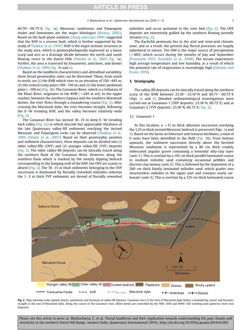
Based on the landform characteristics and altitudinal variability,three broad geomorphic units can be discerned. These, from southto north, are (i) the KHR which rises to an elevation of 150e445 m,(ii) the central rocky plain (100e150m) and (ii) the lower piedmontplain (<100 m) (Fig. 1b). The Gunawari River, which is a tributary ofthe Khari River, originates in the KHR (w445 m asl). In the upperreaches, between the northern Satpura and the southern Marutonkdomes, the river flows through a meandering course (Fig. 2). Aftercrossing the Marutonk dyke, the river becomes straight, followingthe EeW trending KHF, and the valley becomes relatively wide(Fig. 2).
The Gunawari River has incised 10�15 m deep EeW trendingback valley (Fig. 1c) in which discrete but appreciable thickness ofthe late Quaternary valley-fill sediments overlying the incisedMesozoic and Palaeogene rocks can be observed (Thakkar et al.,1999; Patidar et al., 2007). Based on their geomorphic positionand sediment characteristics, these deposits can be divided into (i)older valley-fills (OVF) and (ii) younger valley-fill (YVF) deposits(Fig. 2). The older valley-fill deposits can be laterally traced alongthe northern flank of the Gunawari River. However, along thesouthern flank which is marked by the steeply dipping bedrockcorresponding to the hanging wall of the KHF, the OVF are scanty orabsent (Fig. 2). The 10�15 m thick sediments belonging to the OVFsuccession is dominated by fluvially reworked miliolites whereasthe 1�2 m thick YVF sediments are devoid of fluvially reworked
Fig. 2. Map showing rocky upland, domes, piedmonts and locations of valley-fill deposits. Gstraight in the east of Marutonk dyke. Along the course of the Gunawari river, elbow benddiagram).
Please cite this article in press as: Bhattacharya, F., et al., Fluvial landformseismicity in the northern Katrol Hill Range, western India, Quaternary I
miliolites and occur proximal to the river bed (Fig. 2). The OVFdeposits are extensively gullied by the southern flowing juvenilestreams (Fig. 2).
The Kachchh peninsula lies in the arid and semi-arid climaticzone, and as a result, the present day fluvial processes are largelyephemeral in nature. The ISM is the major source of precipitation(w80%) which occurs during the months of July and September(Pramanik, 1952; Sontakke et al., 2008). The terrain experienceshigh average temperature and low humidity, as a result of whichthe potential rate of evaporation is exceedingly high (Glennie andEvans, 1976).
3. Stratigraphy
The valley-fill deposits can be laterally traced along the northernscarp of the KHR between 23.18�e23.19�N and 69.71�e69.75�E(Figs. 1c and 2). Detailed sedimentological investigations werecarried out at Gunawari-1 (OVF deposits; 23.18�N, 69.72�E) and atGunawari-2 (YVF deposits; 23.18�N, 69.73�E; Fig. 2).
3.1. Gunawari-1
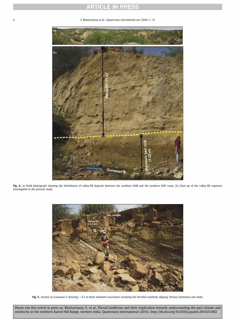
At this location, a w11 m thick alluvium succession overlyingthe 1.25m thick incisedMesozoic bedrock is preserved (Figs. 3a and4). Based on the facies architecture and textural attributes, a total of9 units have been identified in the field (Fig. 3A). From bottomupwards, the sediment succession directly above the beveledMesozoic sandstone is represented by a 80 cm thick crudelyimbricated angular gravel containing a lensoidal silty-clay layer(unit-1). This is overlain by a 145 cm thick parallel laminated coarseto medium miliolite sand containing occasional pebbles anddiscrete clay lamina (unit-2). This is followed by the deposition of a260 cm thick faintly laminated miliolite sand, which grades intostructureless miliolite in the upper part and contains marly car-bonate (unit-3). This is overlain by a 125 cm thick laminated coarse
unawari river in the west of Marutonk dyke follow a meandering course and becomess are controlled by the NNEeSSW and NNWeSSE trending joint patterns (inset rose
s and their implication towards understanding the past climate andnternational (2014), http://dx.doi.org/10.1016/j.quaint.2014.03.002
Fig. 3. Detail stratigraphy of the valley-fill deposits at Gunawari-1 (A) and Gunawari-2 (B). Rectangles and circles represent locations of OSL and geochemistry samples respectively.
F. Bhattacharya et al. / Quaternary International xxx (2014) 1e134
to medium miliolite sand which is punctuated by sandyeclay in-tercalations (unit-4). This horizon is overlain by a 180 cm thickpedogenised clayey-silt containing dispersed calcretes in the upperpart (unit-5) and is succeeded by a 60 cm thick laminated miliolitehorizon. This horizon contains multiple sandyeclay units and iscapped by a clay layer towards the upper part (unit-6). This isoverlain by a 110 cm thick structureless pedogenised clayey-siltcontaining platy litho-clasts at the bottom (unit-7) and is suc-ceeded by a 40 cm thick crudely laminated platy lithoclast domi-nated miliolite (unit-8). The succession terminates with thedeposition of w90 cm thick poorly organized platy litho-clastdominated gravels (unit-9).
3.2. Gunawari-2
At this location, 2.5 m thick sediment succession rests overw2m thick beveled and incised limestones and shales (Figs. 3b and5). From bottom upward, the sediment succession begins with thedeposition of a 40 cm thick angular to sub-rounded litho-clast(unit-1) which is overlain by a 2.0 m thick structureless, medium tocoarse sand. The upper 20�50 cm of this horizon contains a weakplaty litho-clast layer (unit-2).
4. Optical dating
Samples from freshly exposed sections were collected inaluminum pipes from five sedimentary units (viz. unit-1,3,4,9 atGunawari-1 and from unit-2 at Gunawari-2; Fig. 3A and B). Basicprinciples of luminescence dating are discussed in Aitken (1998).The samples were treated with 10% HCl and 30% H2O2 to remove
Please cite this article in press as: Bhattacharya, F., et al., Fluvial landformseismicity in the northern Katrol Hill Range, western India, Quaternary I
the carbonates and the organic matters respectively and then drysieved to obtain a 90�150 mm size fraction. This fraction is thentreated with 40% HF acid to remove the outerw20 mm alpha skin ofquartz. Pure quartz is extracted using the Frantzmagnetic separator(Model LB1). The quartz grains were mounted as a monolayer onstainless steel discs using Silkospray� and the purity of thesegrains (feldspar contamination) was checked by infrared stimu-lated luminescence. All the samples were stimulated using blueegreen stimulation light source provided with a RisØ TA-DA-15reader. The detection optics comprised 2 � U-340 and BG-39 fil-ters. Beta irradiation was made using a 25 mCi 90Sr/90Y source. Theelemental concentrations of uranium and thorium and potassiumwere estimated using the high purity Germanium detector.
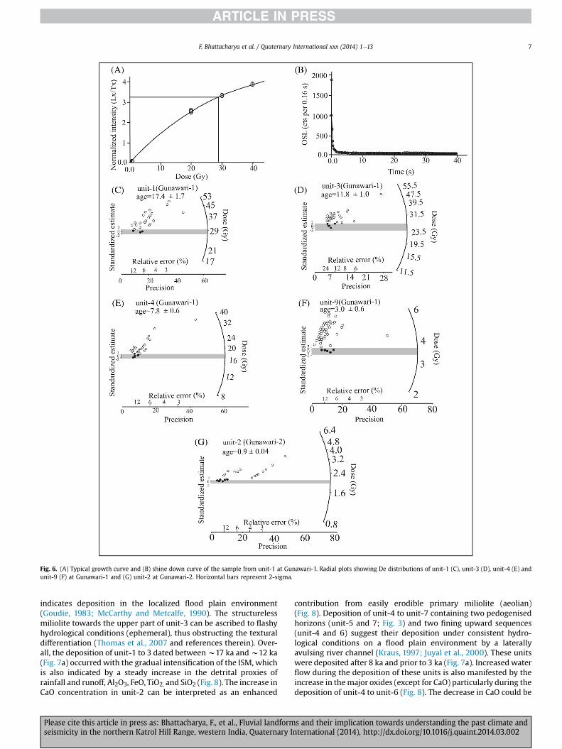
The samples were analyzed using the Single Aliquot Regenera-tion (SAR) protocol of Murray and Wintle (2000). Typically, about70 discs were measured and of these around 35�40 satisfied thecriterion of a recycling ratio of 0.90e1.1. In order to ascertain thedose response, a few samples were subjected to a dose recovery testand within the error, the ratio of the given to recovered dose wasnear to unity (0.98 � 0.08). For the estimation of De, we used theMinimum Age Model (MAM) suggested by Galbraith and Laslett(1993) and the Central Age Model (CAM) of Galbraith et al.(1999). The De values show wide scatter which is also observedin the overdispersion of >30% in CAM. This is expected becauseduring the fluvial transport, sediment grains receive an attenuatedflux of sunlight due to the water column, turbidity and duration oftransport (Srivastava et al., 2001). Particularly for dry-land sedi-ments (as in the present case), which by virtue of their depositionalpattern are likely to suffer differential bleaching under the samedepositional environment. In view of this, in the subsequent
s and their implication towards understanding the past climate andnternational (2014), http://dx.doi.org/10.1016/j.quaint.2014.03.002
F. Bhattacharya et al. / Quaternary International xxx (2014) 1e13 5
discussion theMAMwas used. Fig. 6 gives a growth curve (6a) and ashine down curve (6b) for the lowermost sample (unit-1) and theradial plots of all the five samples (6ce6g). From the older valley-fillsequence the lowermost sample dated from unit-1at Gunawari-1gave an age of 17.4 � 1.7 ka, unit-3 is dated to 11.8 � 1 ka, unit-4 isdated 7.8 � 0.6 ka whereas the topmost unit-9 gave an age of3 � 0.6 ka (Fig. 7a). The younger valley-fill sequence (unit-3) atGunawari-2 is dated to 0.9 � 0.04 ka (Fig. 7b). Table 1a and bprovides the details of the radioactivity, equivalent dose, doserate and ages computed using MAM and CAM.
Table 1(a) Details of radioactivity and dose rate obtained using the Single Aliquot Regen-eration (SAR) methods. (b) Palaeodose and ages obtained using CAM and MAMmethods.
Locations Sample no. U (ppm) Th (ppm) K (%) Dose rate(Gy/ka)
Water content (wt%) ¼ 10 � 2 Cosmic ray ¼ 119 � 12 mGy/a.
5. Geochemistry
It has been suggested that synchronous variation in major ox-ides such as Al2O3, FeO, TiO2, and SiO2 mimic the temporal changesin detrital input (provenance) and thus can be used as a measure ofpast rainfall and runoff (Lisitzin, 1996; Peterson et al., 2000; Juyalet al., 2009). Therefore, in order to ascertain the temporalchanges in valley-fill aggradation, each unit at Gunawari-1 issampled (except unit-7 and 8, due to inaccessibility) forgeochemical analyses (major oxides). From each unit, two to threesub- samples were collected and homogenized so as to obtain anaverage/representative concentration values. The major oxideswere analyzed using X-ray fluorescence (XRF) technique at Na-tional Facility for Planetary Science and Exploration Program ofIndian Space Research Organization (ISRO), at Physical ResearchLaboratory, Ahmedabad. The finely powdered samples (w2.0 g)were mixed homogeneously with 0.5 g wax binder in agate-pestleand mortar. The mixture was filled in the standard aluminium cups
Table-2Major elements concentration and Chemical Index of Alteration obtained from various u
Please cite this article in press as: Bhattacharya, F., et al., Fluvial landformseismicity in the northern Katrol Hill Range, western India, Quaternary I
(37 mm) and then subjected to 150 kN pressure using hydraulicpress for about a minute. The pressure was removed slowly andstandard pellets were recovered and were subjected to the X-rayfluorescence (XRF) spectrometry (Axios, from Panalytical limited).The analytical precision at 2 sigma level is considered for majoroxides which is better than 5% (Shukla, 2011). Attempt has alsobeen made to ascertain the relative change in weathering intensityby using the conventional Chemical Index of Alteration (CIA)technique in decarbonated samples. CIA is defined asCIA ¼ 100 � (Al2O3)/(Al2O3þCaO þ Na2O þ K2O)] (Nesbitt andYoung, 1982). There is a gradual increase in Al2O3 from 9.77%(Unit-1) to 11.89% (unit-6) followed by a marginal decline to 11.1%(unit-9). The maximum value of 11.89% was obtained from unit-6.Identical trends were observed for FeO, TiO2, and SiO2 (Table-2,Fig. 8). A gradual decline in CIAwas observed from unit-1 (84.71) tounit-4 (69.55) followed by an increase in the value towards unit-6(86.82) (Table-2; Fig. 8). At Gunawari-2, we observed relatively highconcentrations of Al2O3 (13.36%), FeO (7.36%), and TiO2 (0.9%) andsignificantly low concentrations of CaO (6.61%) (Table-2).
6. Depositional environment
The incised sedimentary succession at Gunawari-1 showsdetailed facies variability in the Gunawari River valley. On the basisof sedimentological observations, it can be suggested that sedi-mentation occurred on the beveled Mesozoic bedrock surfaceimplying that before the deposition of unit-1 (Fig. 3), beveling ofthe bedrock surface occurred due to the change in the ratio ofvertical incision to lateral planation, a typical feature in a downcutting river (Hancock and Anderson, 2002). Once the sedimentsupply increases, the lateral planation of the bedrock is preventeddue to the overlying sediment cover (Lave and Avouac, 2001). Thiswould imply that the accommodation space for the valley-fillsedimentation on the Mesozoic bedrock surface was created dur-ing conditions of low sediment supply. The dominance of crudelyimbricated, angular to sub-rounded lithoclast with silty-clay lenses(unit-1), suggests deposition under sub-aqueous conditions. Theseare typical matrix-supported framework mass-flow deposits, alsocalled hyperconcentrated flows (Miall, 1996). In such flows, thegravelly lithoclasts are embedded in sand and mud matriceswherein the interstitial water has enough cohesive strength toprevent larger particles from settling but not enough strength toprevent the flow. These hyperconcentrated flows are known tohave been caused by episodic discharges in ephemeral rivers(Wasson, 1979; Miall, 1996; Knighton and Nanson, 1997). Sedimentcharacteristics (laminated coarse to medium miliolite sand withoccasional pebbles and clay lamina) of unit-2 suggests increasedwater flow. The presence of subordinate pebbles indicate that op-timum segregation of the sediments was not achieved in the mainchannel before the floods spilled over the banks during the highermagnitude flood events (Thomas et al., 2007). Occurrence of faintlylaminated tomassive miliolite alongwithmarly carbonate in unit-3
nits at Gunawari-1and Gunawari-2.
iO2% Error% SiO2% Error% CaO% Error% CIA%
.46 0.02 55.59 2.78 14.93 0.75
.53 0.03 61.31 3.07 11.67 0.58 86.82
.45 0.02 61.31 3.07 12.78 0.64 72.23
.41 0.02 60.14 3.01 12.84 0.64 69.55
.44 0.02 54.21 2.71 14.91 0.75 75.86
.41 0.02 54.18 2.71 17.00 0.85 77.14
.4 0.02 60.66 3.03 11.83 0.59 84.71
.9 0.045 50.93 2.54 6.61 0.33
s and their implication towards understanding the past climate andnternational (2014), http://dx.doi.org/10.1016/j.quaint.2014.03.002
Fig. 5. Section at Gunawari-2 showing w2.5 m thick sediment succession overlying the beveled southerly dipping Tertiary limestone and shale.
Fig. 4. (a) Field photograph showing the distribution of valley-fill deposits between the southern KHR and the northern KHF scarp. (b) Close-up of the valley-fill sequenceinvestigated in the present study.
F. Bhattacharya et al. / Quaternary International xxx (2014) 1e136
Please cite this article in press as: Bhattacharya, F., et al., Fluvial landforms and their implication towards understanding the past climate andseismicity in the northern Katrol Hill Range, western India, Quaternary International (2014), http://dx.doi.org/10.1016/j.quaint.2014.03.002
Fig. 6. (A) Typical growth curve and (B) shine down curve of the sample from unit-1 at Gunawari-1. Radial plots showing De distributions of unit-1 (C), unit-3 (D), unit-4 (E) andunit-9 (F) at Gunawari-1 and (G) unit-2 at Gunawari-2. Horizontal bars represent 2-sigma.
F. Bhattacharya et al. / Quaternary International xxx (2014) 1e13 7
indicates deposition in the localized flood plain environment(Goudie, 1983; McCarthy and Metcalfe, 1990). The structurelessmiliolite towards the upper part of unit-3 can be ascribed to flashyhydrological conditions (ephemeral), thus obstructing the texturaldifferentiation (Thomas et al., 2007 and references therein). Over-all, the deposition of unit-1 to 3 dated betweenw17 ka andw12 ka(Fig. 7a) occurred with the gradual intensification of the ISM, whichis also indicated by a steady increase in the detrital proxies ofrainfall and runoff, Al2O3, FeO, TiO2, and SiO2 (Fig. 8). The increase inCaO concentration in unit-2 can be interpreted as an enhanced
Please cite this article in press as: Bhattacharya, F., et al., Fluvial landformseismicity in the northern Katrol Hill Range, western India, Quaternary I
contribution from easily erodible primary miliolite (aeolian)(Fig. 8). Deposition of unit-4 to unit-7 containing two pedogenisedhorizons (unit-5 and 7; Fig. 3) and two fining upward sequences(unit-4 and 6) suggest their deposition under consistent hydro-logical conditions on a flood plain environment by a laterallyavulsing river channel (Kraus, 1997; Juyal et al., 2000). These unitswere deposited after 8 ka and prior to 3 ka (Fig. 7a). Increased waterflow during the deposition of these units is also manifested by theincrease in themajor oxides (except for CaO) particularly during thedeposition of unit-4 to unit-6 (Fig. 8). The decrease in CaO could be
s and their implication towards understanding the past climate andnternational (2014), http://dx.doi.org/10.1016/j.quaint.2014.03.002
Fig. 7. Chronology of the valley-fill sequence at Gunawari-1 and 2.
F. Bhattacharya et al. / Quaternary International xxx (2014) 1e138
due to the reduction in the availability of easily erodible aeolianmiliolites in the Gunawari river catchment. Deposition of crudelylaminated platy litho-clast dominated miliolite (unit-8) can beinterpreted as weakening of the hydrological condition (onset ofdryness) which seems to be further enhanced during the deposi-tion of poorly graded and platy gravels dominated unit-9 dated to3 ka (Fig. 7a). Texturally this unit suggests that the sediments weretransported as debris flows (Iverson, 1997; Griffiths et al., 2004).Compared to the major oxides, CIA shows a decreasing trend untilthe deposition of unit-4 (Fig. 8). This is ascribed to the primaryweathering that occurred in the river catchment. An increase in CIAcorresponding to unit-5 (pedogenized horizon) and 6 (dominanceof clay) can be attributed to post-depositional weathering causeddue to frequent and prolonged sub-areal exposures (Fig. 8) due tothe existence of a laterally avulsive fluvial system during thedeposition of unit-5 and 6.
At Gunawari-2, the beveled Cenozoic bedrock can be laterallycorrelated with that of Gunawari-1. However, absence of oldervalley-fill at Gunawari-2 could be due to post- depositional erosionin the lower reaches of the river valley. The limestone and shaledominated angular boulders which directly overlies the Cenozoicbedrock suggests their deposition during a short-lived storm surgeflood event from the surrounding slopes (Fig. 3B). However, theoverlying structureless, medium to coarse sand horizon dated to1 ka can be interpreted as deposition under low energy conditionsfrom the upper catchment (Fig. 7b). The high concentrations ofAl2O3, FeO, and TiO2 and low concentrations of CaO (Table-2) in thesand horizon indicate a change in the sediment provenance fromaeolian miliolites to the Mesozoic and Cenozoic rocks of the KatrolHill Range.
Please cite this article in press as: Bhattacharya, F., et al., Fluvial landformseismicity in the northern Katrol Hill Range, western India, Quaternary I
7. Discussion
7.1. Palaeoenvironment
The amplified geomorphic and sedimentological responses ofthe dry-land fluvial system make them suitable archives forreconstruction of the past hydrological conditions (Nanson andTooth, 1999). For example, a river that is adjusted to carry thesediment loads during the enhanced and persistent discharge (wetcondition) undergoes changes in form and function during cold anddry phases (Williams et al., 1998). Studies carried out in westernIndia show that the sedimentary architecture of the dry-land fluvialsystems can be used to reconstruct the past ISM variability (Tandonet al., 1997; Juyal et al., 2000; Srivastava et al., 2001; Juyal et al.,2006). The present study is a new contribution from the extremewestern part of India for which the post-LGM monsoon recon-struction based on fluvial archives are virtually non-existent.
The sedimentary characteristics of unit-1, which overlies thebeveled Mesozoic bedrock and is dated to 17 ka (Fig. 7a), suggeststhat deposition occurred under hyperconcentrated sedimentgravity flow, implying the onset of the monsoon activity followingthe LGM (Duplessy et al., 1980). A similar observation was made inthe adjoining channel-fill sequence in Katrol hill by Bhattacharyaet al. (2013). The valley-fill sediments are derived from thebiogenic carbonates (miliolite) which were primarily deposited asobstacle dunes (aeolian) on the southern face of the Katrol hill(Biswas, 2005; Mathur, 2005, Fig.1c). This would imply that prior tothe deposition of unit-1, the terrain was experiencing enhancedaridity, which progressively weakened as indicated by the initiationof the valley-fill sedimentation around 17 ka. Occurrences ofoverlying parallel laminated coarse to medium miliolite sand andenhanced concentration of CaO along with marginal increase inAl2O3 after 17 ka (unit-2) is suggestive of a steady increase inmoisture condition (Fig. 8). The facies architecture correspondingto unit-3 to unit-6 and the overall increase in the detrital proxiesviz. Al2O3, FeO, TiO2 and SiO2 (dated between 12 ka to <8 ka)suggests an overall strengthened monsoon condition with fluctu-ations (Figs. 7a and 8). Evidence similar to this was obtained byMathew et al. (2006) from the northern part of the study area andthe present study accords well with the continental and marinerecords which show an early Holocene strengthened monsoonfollowed by a gradual decline after themid-Holocene (Sirocko et al.,1993). For example, the early Holocene humid phase was charac-terized by revival of fluvial activity in the Indian subcontinent andincreased weathering and fluvial erosion in many parts of penin-sular India (Kale, 2007). In the adjoining channel-fill section, thisperiod is represented by the presence of laminated miliolite andweathered fluvial sediments which are optically dated between9 ka and 7 ka (Fig. 9) andwas attributed to a strengthenedmonsoonin the region (Bhattacharya et al., 2013). Compilation of the pa-leoclimatic data obtained from lakes and peat bogs from Thardesert, Ganga plain and Himalaya, indicates overall strengthenedmonsoonwith fluctuations during 12 ka to 8 ka (Chamyal and Juyal,2008 and references therein). The texture and pattern of sedi-mentation corresponding to unit-8 and 9 indicate gradual declinein themonsoon intensity which is also supported by the decrease inmajor oxide concentration (Fig. 8). Combining the chronometricdata from channel-fill sequence (Bhattacharya et al., 2013) withthat of the valley-fill sequence, the decline inmonsoon strength canbe bracketed between 7 ka and 3 ka (Figs. 7a and 8). Further, thevalley-fill and the channel-fill deposits show a broad similarity intime contemporaneous sedimentation patterns (Fig. 9), implyingbasin-wide response to ISM variability in southern Kachchh.
The continental record of monsoon variability suggests arid toephemeral lake conditions after the mid-Holocene, implying an
s and their implication towards understanding the past climate andnternational (2014), http://dx.doi.org/10.1016/j.quaint.2014.03.002
Fig. 8. Concentration variability of major oxides and Chemical Index of Alteration corresponding to different units at Gunawari-1 (older valley-fill deposits).
Fig. 9. Lateral correlation of channel-fill and valley-fill deposits.
F. Bhattacharya et al. / Quaternary International xxx (2014) 1e13 9
Please cite this article in press as: Bhattacharya, F., et al., Fluvial landforms and their implication towards understanding the past climate andseismicity in the northern Katrol Hill Range, western India, Quaternary International (2014), http://dx.doi.org/10.1016/j.quaint.2014.03.002
Fig. 10. Major discontinuity in the longitudinal river profiles of the (a) Gunawari (b)Khari rivers are observed where these rivers cut across the Transverse fault (TF) andKHF. In addition to this, the river also shows deviation from the graded profile where itencounters the domal and anticlinal structures.
F. Bhattacharya et al. / Quaternary International xxx (2014) 1e1310
overall weakened monsoon (Chamyal and Juyal, 2008). Absence ofvalley-fill sediments younger than 3 to>1 ka suggests a decrease inthe river’s carrying capacity, which can be ascribed to the preva-lence of a weakmonsoon as observed in the semi-arid Penner Riverof southern India (Thomas et al., 2007), and in the Narmada andTapi river basins of Central India (Kale et al., 2003b). Therefore, wesuggest that the incision of the valley-fill sediments and the un-derlying bedrock occurred during the weak monsoon that beganafter 3 ka and continued until around >1 ka. The younger valley-fillsequences that were deposited around 1 ka suggest resumption of ashort-lived strengthened monsoon phase in the region. Similarobservations were made in the southern Penner river (Thomaset al., 2007), Narmada and Tapi river basins, Central India (Kaleet al., 2003b) and the Luni river in western Thar desert (Kaleet al., 2000).
7.2. Palaeoseismicity
Studies pertaining to late Quaternary deformations from theregion are limited. However, the existing studies suggest that theterrain proximal to the KHF experienced major earthquakes in thepast (Morino et al., 2008; Kundu et al., 2010) and continuedduring recent historical times (Rajenderan and Rajenderan, 2001).Considering the seismically active nature of the KHF (Patidaret al., 2007; Bhattacharya et al., 2013), we looked for themorphological expression of enhanced uplift using
Please cite this article in press as: Bhattacharya, F., et al., Fluvial landformseismicity in the northern Katrol Hill Range, western India, Quaternary I
geomorphology supported by structural and joint pattern anal-ysis. The joint pattern analysis provided an insight into thepattern of stress regime prevailing through time, whereas theoptical chronology of the sedimentary successions helped inquantifying the incision/uplift rates.
Seismically active nature of the study area is manifested by thepresence of joints on the Mesozoic bedrock. The rose diagram plotssuggest two major joint trends, NNW-SSE and NNE-SSW (Fig. 2;inset rose diagram). The joint patterns seem to dictate the course ofthe Gunawari River as indicated by sharp elbow bends of the riverswhich are sympathetic to the NNW-SSE and NNE-SSW joint trends(Fig. 2). Similar studies in the KHF have been done by Sohoni et al.(1999), where they observed a similar trend of the major joints,N80�E/79�S (NNEeSSW).
Further, the ongoing process of domal up-warping in the area ismanifested by development of knick points where the Gunawaririver cuts across the Marutonk dome in the west and the Ler domein the east (Fig. 10). Influence of tectonically induced change in theriver gradient is manifested by the change from a meanderingcourse (west of Marutonk dyke) to a straight course in the east untilthe river reaches the Ler dome (Fig. 2). A river flowing throughvarying degree of valley slopes tends to meander in higher slopesegments in order to dissipate its energy, whereas in the lowerslope segments, the river follows a rather straighter course(Schumm, 1993). The above geomorphic expressions are furthersupported by the morphometric indices such as drainage density(Dd) and valley floor width ratio (Vf). Increase in Dd and decrease inVf ratio are considered as an expression of tectonic instability(Keller and Pinter, 1996). The higher Dd value of 2.9 km/km2 isobserved in the west of Marutonk dyke, decreasing to 1.9 km/km2
in the eastern part of the Gunawari valley. Similarly, the valley floorwidth ratio (Vf) shows an increasing trend from west (0.5) to east(3.5). These indices support the observation that thewestern part ofthe Gunawari river is experiencing relatively higher upliftcompared to its eastern counterpart.
Based on the above observations, we suggest that the terrainexperienced two major events of enhanced uplift. The older event,>17 ka, led to the vertical incision and lateral planation of theMesozoic bedrock which subsequently accommodated the post-LGM valley-fill aggradation. Morpho-tectonic considerations sug-gest that the incision of the southern scarp surface (below thepiedmont zone; Fig. 2) and the development of the transversegorgewould have started during the older event of enhanced uplift.However, the southerly draining juvenile first order streams (Fig. 2)seems to be the later phenomenon, as these streams wereresponsible for the transportation and deposition of primary mil-iolite (aeolian) from the southern slopes of the south-dipping KHFduring the phase of relative stability.
The terrain experienced a second phase of enhanced upliftw3 ka that led to the deposition of the uppermost debris-flowfollowed by the incision of the valley-fill and the underlyingMesozoic bedrock. Our observations are in conformity with thestructural evidence obtained by Morino et al. (2008); they havesuggested the presence of active faults in the vicinity of Wandhaydam site which is located w7 km northwest of the present studyarea. According to them, at least three large magnitude seismicevents along 3major fault strands F1, F2 and F3 represent the latest,penultimate and the older than penultimate events respectively.These events have displaced terrace units as well as the overlyingyounger channel-fill deposits. Based on the stratigraphic positionand the sediment texture, this unit is comparable with the 3 kadebris-flow event of the Gunawari river (Fig. 3). This further sup-ports the suggestion that the terrain was tectonically active asrecent as <3 ka. However, the tectonic intervention was rather lowbetween 17 and 3 ka, when the monsoon was adequately strong.
s and their implication towards understanding the past climate andnternational (2014), http://dx.doi.org/10.1016/j.quaint.2014.03.002
Fig. 11. A composite stratigraphy and optical ages obtained on the valley-fills (present study) and channel-fills (after Bhattacharya et al., 2013). The inferred fluvial processes basedon facies architecture accords well with the isotopic proxy of monsoon variability reconstructed from the Guliya ice core data (Thomson et al., 1997). The two major events ofenhanced uplift/incision are assigned >20 ka (older event) and <3 ka (younger event). The solid black arrow mimics the relative magnitude of uplift. OVF e Older valley-fill, YVF e
Younger valley-fill.
F. Bhattacharya et al. / Quaternary International xxx (2014) 1e13 11
In a down-cutting river, the rock uplift is equal to the river inci-sion as measured from the elevation of the fill surface above thepresent day river channel (Burbank et al., 1996; Lave and Avouac,2001). Ideally, uplifted bedrock strath terraces are considered thebest geomorphic features for estimating the incision/uplift rates astectonic analysis of the strath is not susceptible to climate-inducedeffects (Avouac, 2003). However, in the present case, due to thevariable sedimentary succession overlying the bedrock strath, weconsidered the total thickness including the valley-fill and theincised bedrock and divided it by the uppermost age to get the timeaveraged long-term incision rate (Lave and Avouac, 2001). Based onthis, the long-term incision rate of 4.0� 0.8 mm/y was obtained forthe valley-fill sequence. This is comparablewith that of the channel-fill section along the Khari River, where an incision rate of3.1 � 0.4 mm/y was obtained. However, compared to Mathew et al.(2006) who obtained w10 mm/y from KMF and the recent GPSbased instantaneous crustal shortening rate of w12 mm/y (Jadeet al., 2002), our estimate are on the lower side. We speculate thatthe higher incision rate obtained by Mathew et al. (2006) on KMFcould (i) be due to that the fact that KHF is undergoing lesser degreeof deformation compared to KMF and the latter is the principleactive fault in the Kachchh Mainland (Biswas, 2005) which is likelyto assimilate the major strain during the regional deformation(Burbank and Anderson, 2001); or (ii) Similarly the higher crustalshortening obtained based on the GPS measurements are
Please cite this article in press as: Bhattacharya, F., et al., Fluvial landformseismicity in the northern Katrol Hill Range, western India, Quaternary I
instantaneous shortening rates (Mathew et al., 2006) and could bean artifact of the short time averaged expression of the cumulativeslip of the four major faults: KMF, IBF (Island Belt Fault), Allah BundFault and KHF (Kundu et al., 2010).
Fig. 11 summarizes the observations made during the presentstudy. Fluvial sedimentation commenced around 20 ka and per-sisted until around 1 ka. During this period, monsoon driven hy-drological variability led to significant changes in the pattern offluvial processes. Onset of the ISM after the LGM led to the devel-opment of a braided fluvial system that persisted until ca. 17 ka. Agradual strengthening of ISM followed by overall strengthenedmonsoon with fluctuation was observed after 12 ka and 8 ka. Thisled to the development of a meandering river system with floodplains. After 7 ka, the declining ISM monsoon facilitated thedevelopment of an avulsive fluvial system which facilitated thedevelopment of flood plain pedogenesis. Decreased river flowoccurred w3 ka, when the slope-induced processes (debris flow)overwhelmed the fluvial sedimentation, implying the onset of thearidity in the region. This phase was punctuated by a short-livedenhanced ISM before the onset of present day aridity w1 ka thatled to the deposition of the younger valley-fill sequence proximal tothe river bed.
Two major events of enhanced uplift are inferred. The olderevent, which is dated to >20 ka, was responsible for the creation ofaccommodation space for valley and channel-fill sedimentation.
s and their implication towards understanding the past climate andnternational (2014), http://dx.doi.org/10.1016/j.quaint.2014.03.002
F. Bhattacharya et al. / Quaternary International xxx (2014) 1e1312
Compared to this, the younger event<3 ka led to the incision of thefill sediment along with the underlying bedrock, and the evolutionof the present day fluvial landforms in Gunawari river valley. Thetime averaged incision rate indicates that the terrain in the vicinityof the KHF is uplifting at w4 mm/y.
8. Conclusions
A broad correspondence of the monsoon reconstruction basedon the valley-fill and the channel-fill deposits with that of theregional climate pattern indicates that the Kachchh peninsula inthe western India responded in accordance with the regional cli-matic variability during the post-LGM period.
A progressive strengthening of monsoonwas observed between17 and 12 ka and an overall strengthenedmonsoonwith fluctuationis inferred between 12 ka and <8 ka. This was followed by a steadydecline in monsoon strength during after 8 ka to 3 ka. Presence ofthe younger fill sequences proximal to the present day riverchannel dated to w1 ka indicates a short-lived phase of renewedstrengthened ISM before the onset of present day aridity.
For the first time, optical chronology suggests that the older (pre17 ka) event of enhanced uplift led to the vertical incision andlateral planation of the Mesozoic bedrock which subsequentlyprovided accommodation space for the post glacial valley-fillaggradation. The younger <3 ka uplift event is responsible for theincision of the valley-fill and the channel-fill sediments along withthe bedrock incision.
The time averaged incision rate indicates that the terrain isuplifting at a rate ofw4mm per year. Considering that the Kachchhpeninsula is under compressive stress (Biswas, 2005), we ascribethe periods of enhanced uplift as observed in the present study tothe episodic release of the compressive stress.
Acknowledgements
We are thankful to two anonymous reviewers for providingvaluable suggestions and comments which helped in improving themanuscript significantly. Dr Anil Shukla is thanked for providingthe major element data. Falguni Bhattacharya expresses her grati-tude to Prof. A.K. Singhvi for introducing her to the optical datingtechnique. Authors are thankful to Mamata Mgangom, MadhaviDhabi and Keyur Pandeya of K.S.K.V. Kachchh University, Bhuj,Kachchh for their assistance during the field-work.
Appendix A. Supplementary data
Supplementary data related to this article can be found at http://dx.doi.org/10.1016/j.quaint.2014.03.002.
References
Aitken, M.J., 1998. Introduction to Optical Dating. Oxford University Press, Oxford,p. 267.
Avouac, J.P., 2003. Mountain building, erosion and the seismic cycle in the NepalHimalaya. Advances in Geophysics 46, 1e79.
Bhattacharya, F., Rastogi, B.K., Ngangom, M., Thakkar, M.G., Patel, R.C., 2013. LateQuaternary climate and seismicity in the Katrol Hill range, Kachchh, westernIndia. Journal of Asian Earth Sciences 73, 114e120.
Biswas, S.K., 2005. A review of structure and tectonics of Kutch basin, western India,with special reference to earthquakes. Current Science 88, 1592e1600.
Burbank, D.W., Leland, J., Fielding, E., Anderson, R.S., Brozovic, N., Reid, M.R.,Duncan, C., 1996. Bedrock incision, rock uplift, and threshold hillslopes in thenorthwestern Himalayas. Nature 379, 505e510.
Chamyal, L.S., Juyal, N., 2008. Late Quaternary continental studies in parts of India:implications for monsoon variability. Journal Geological Society of India 71,611e629.
Please cite this article in press as: Bhattacharya, F., et al., Fluvial landformseismicity in the northern Katrol Hill Range, western India, Quaternary I
Chung, W.Y., Gao, H., 1995. Source parameters of the Anjar earthquake of July 21,1956, India and its seismotectonic implications for the Kachchch rift basin.Tectonophysics 242, 281e292.
Duplessy, J.C., Moyes, J., Pujol, C., 1980. Deep water foundation in the North AtlanticOcean during the Last Ice Age. Nature 286, 479e482.
Galbraith, R.F., Roberts, R.G., Laslett, G.M., Yoshida, H., Olley, J.M., 1999. Opticaldating of single and multiple grains of quartz from Jinmium Rock Shelter,Northern Australia: part I, experimental design and statistical models.Archaeometry 41, 339e364.
Glennie, K.W., Evans, G., 1976. A reconnaissance of the recent sediments of theRanns of Kutch, India. Sedimentology 23, 625e647.
Goudie, A.S., 1983. Calcrete. In: Goudie, A.S., Pye, K. (Eds.), Chemical Sediments andGeomorphology. Academic Press, London, pp. 93e132.
Griffiths, Peter G., Webb, Robert, H., Melis, Theodore, S., 2004. Frequency andinitiation of debris flows in Grand Canyon, Arizona. Journal of GeophysicalResearch 109, F04002 doi:10. 1029/2003JF000077.
Hancock, G.S., Anderson, R.S., 2002. Numerical modeling of fluvial strath-terraceformation in response to oscillating climate. Geological Society of AmericaBulletin 114, 1131e1142.
Howard, A.D., Dietrich, W.E., Seidl, M.A., 1994. Modeling fluvial erosion onregional to continental scales. Journal of Geophysical Research 99 (B7),13,971e13,986.
Iverson, R.M., 1997. The physics of debris flows. Review of Geophysics 35, 245e266.Jade, S., Mukul, M., Parvez, I.A., Ananda, M.B., Kumar, P.D., Gaur, V.K., 2002. Esti-
mates of coseismic displacement and post deformation using Global PositioningSystem geodesy for the Bhuj earthquake of 26 January, 2001. Current Science82, 748e752.
Juyal, N., Raj, R., Maurya, D.M., Chamyal, L.S., Singhvi, A.K., 2000. Chronology of latePleistocene environmental changes in the lower Mahi basin, western India.Journal of Quaternary Science 15, 501e508.
Juyal, N., Chamyal, L.S., Bhandari, S., Bhushan, R., Singhvi, A.K., 2006. Continentalrecord of the southwest monsoon during the last 130 ka: evidence from thesouthern margin of the Thar Desert, India. Quaternary Science Reviews 25,2632e2650.
Juyal, N., Pant, R.K., Basavaiah, N., Bhushan, R., Jain, M., Saini, N.K., Yadava, M.G.,Singhvi, A.K., 2009. Reconstruction of Late Glacial to early Holocene monsoonvariability from relict lake sediments of the Higher Central Himalaya, Uttrak-hand, India. Journal of Asian Earth Science 34, 437e449.
Kale, P., Singh, H., Perlmutter, H., 2000. Learning and protection of proprietary as-sets in strategic alliances: building relational capital. Strategic ManagementJournal 21 (3), 217e237.
Kale, V.S., Mishra, S., Baker, V.R., 2003. Sedimentary records of palaeofloods in thebedrock gorges of the Tapi and Narmada Rivers, central India. Current Science84, 1072e1079.
Kale, V.S., 2007. Fluvio-sedimentary response of the monsoon-fed Indian rivers tolate PleistoceneeHolocene changes in monsoon strength: reconstruction basedon existing C dates. Quaternary Science Reviews 26, 1610e1620.
Keller, A., Pinter, N., 1996. Active Tectonics, Earthquakes, Uplift and Landscape.Prentice-Hall, pp. 1e237.
Knighton, D., Nanson, G., 1997. Distinctiveness, diversity and uniqueness in aridzone river systems. In: Thomas, D.S.G. (Ed.), Arid Zone Geo-morphology: Pro-cess, Form and Change in Drylands. Wiley, Chichester, pp. 185e204.
Kundu, H.K., Thakkar, M.G., Biswas, R.H., Singhvi, A.K., 2010. Optical dating of sed-iments in Khari river basin and slip rate along Katrol Hill Fault (KHF), Kachchh,India. Geochronometria 37, 21e28.
Lave, J., Avouac, J.P., 2001. Fluvial incision and tectonic uplift across the Himalayas ofcentral Nepal. Journal of Geophysical Researchesolid Earth 106 (B11), 26,561e26,591. http://dx.doi.org/10.1029/2001JB000359.
Lisitzin, A.P., 1996. The Age of Terrigenous Material as an Indicator of its Origins(Age and Isotopic Measurements). Oceanic Sedimentation, Lithology andGeochemistry, American Geophysical Union Publication, pp. 192e230.
Mathew, G., Singhvi, A.K., Karanth, R.V., 2006. Luminescence chronometry andgeomorphic evidence of active fold growth along the Kachchh Mainland Fault(KMF), Kachchh. India: seismotectonic implications. Tectonophysics 422, 71e87.
Mathur, U.B., 2005. Quaternary geology: Indian perspective (with notes on Qua-ternary of Gujarat). Geological Society of India, Memoir 63, 344.
Maurya, D.M., Thakkar, M.G., Chamyal, L.S., 2003. Implications of transverse faultsystem on tectonic evolution of Mainland Kachchh, Western India. CurrentScience 85, 661e667.
McCarthy, T.S., Metcalfe, J., 1990. Chemical sedimentation in Okavango Delta,Botswana. Chemical Geology 89, 157e178.
Miall, A.D., 1996. The Geology of Fluvial Deposits. Springer, Berlin, p. 582.Morino, M., Malik, J.N., Mishra, P., Bhuiyan, C., Kaneko, F., 2008. Active fault traces
along Bhuj Fault and Katrol Hill Fault, and trenching survey at Wandhay,Kachchh, Gujarat, India. Journal of Earth System Science 117, 181e188.
Murray, A.S., Wintle, A.G., 2000. Luminescence dating of quartz using an improvedsingle-aliquot regenerative dose protocol. Radiation Measurement 32, 57e73.
Nanson, G.C., Tooth, S., 1999. Arid-zone rivers as indicators of climate. In:Singhvi, A.K., Derbyshire, E. (Eds.), Palaeoenvironmental Reconstruction in AridLands. Balkema, Rotterdam, pp. 175e216.
s and their implication towards understanding the past climate andnternational (2014), http://dx.doi.org/10.1016/j.quaint.2014.03.002
F. Bhattacharya et al. / Quaternary International xxx (2014) 1e13 13
Nesbitt, H.W., Young, G.M., 1982. Early Proterozoic climates and plate motionsinferred from major element chemistry of lutites. Nature 299, 715e717.
Patidar, A.K., Maurya, D.M., Thakkar, M.G., Chamyal, L.S., 2007. Fluvial geo-morphology and neotectonic activity based on field and GPR data, Katrol HillRange, Kachchh, Western India. Quaternary International 159, 74e92.
Patidar, A.K., Maurya, D.M., Thakkar, M.G., Chamyal, L.S., 2008. Evidence of neo-tectonic reactivation of the Katrol Hill Fault during Late Quaternary and its GPRcharacterization. Current Science 94, 338e346.
Peterson, L.C., Haug, G.H., Hughen, K.A., Rohl, U., 2000. Rapid changes in the hy-drological cycle of the Tropical Atlantic during the Last Glacial. Science 290,1947e1951.
Pramanik, S.K., 1952. Hydrology of the Rajasthan Desert: rainfall, humidity andevaporation. In: Proceedings Symposium Rajputana Desert. National Institute ofScience, India, pp. 183e197.
Pratt-Sitaula, B.A., Burbank, D.W., Heimsath, A., Ohja, T.P., 2004. Landscapedisequilibrium on 1000e10,000 year scales Marsyandi River, Nepal, CentralHimalaya. Geomorphology 58, 223e241.
Rajenderan, C.P., Rajenderan, Kushala, 2001. Characteristics of deformation and pastseismicity associated with the 1819 Kutch earthquake, Northwestern India.Bulletin of the Seismological Society of America 91, 407e426.
Schumm, S.A., 1993. River response to base level change: implications for sequencestratigraphy. Journal of Geology 101, 279e294.
Shukla, A.D., 2011. Geochemical and Isotopic Studies of Some Sedimentary Se-quences of the Vindhyan Super Group, India (Unpublished Ph.D. thesis). M.S.University, Baroda.
Sirocko, F., Sarnthein, M., Erlenkeuser, H., Lange, H., Arnold, M., Duplessy, J.C., 1993.Century-scale events in monsoonal climate over the past 24,000 years. Nature364, 322e324.
Please cite this article in press as: Bhattacharya, F., et al., Fluvial landformseismicity in the northern Katrol Hill Range, western India, Quaternary I
Sohoni, P.S.,Malik, J.N.,Merh, S.S., Karanth, R.V.,1999.Active tectonicsastrideKatrolhillzone, Kachchh, Western India. Journal of Geological Society of India 53, 579e586.
Sontakke, N.A., Singh, H.N., Singh, N., 2008. Chief features of physiographic rainfallvariations across India during instrumental period (1813e2006). Contributionfrom IITM Research Report, N. RR 121. ISSN: 0252-1075 128.
Srivastava, P., Juyal, N., Singhvi, A.K., Wasson, R.J., Bateman, M.D., 2001. Lumines-cence chronology of river adjustment and incision of Quaternary sediments inthe alluvial plain of the Sabarmati River, north Gujarat, India. Geomorphology36, 217e229.
Tandon, S.K., Sareen, B.K., Rao, M.S., Singhvi, A.K., 1997. Aggradation history andluminescence chronology of Late Quaternary semi-arid sequences of theSabarmati basin, Gujarat, western India. Palaeogeography PalaeoclimatologyPalaeoecology 128, 339e357.
Thakkar, M.G., Maurya, D.M., Rachna, R., Chamyal, L.S., 1999. Quaternary tectonichistory and terrain evolution of the area around Bhuj, Mainland Kachchh,Western India. Journal of the Geological Society of India 53, 601e610.
Thomas, P.J., Juyal, N., Kale, V.S., Singhvi, A.K., 2007. Luminescence chronology oflate Holocene extreme hydrological events in the upper Penner river basin,South India. Journal of Quaternary Science 22, 747e753.