Retail Star Limited Level 9, 440 Collins Street, Melbourne Vic 2000 P. +61 3 9607 1322 F. +61 3 9607 1329 www.retailstar.net.au ABN 71 098 238 585 7 July 2008 RETAIL STAR LIMITED EXPLORATION UPDATE MALAWI EXPLORATION HIGHLIGHTS • Completion of scintillometer survey at 200 metre line spacing over the entire 7 kilometre-long Main Machinga Radiometric Anomaly • Infill 50 metre line spacing scintillometer survey underway over the Northern Main Machinga Anomaly • Defined 2000 metre-long by 200-500 metres wide anomalous Niobium-Zirconium (+Tantalum?) zone within pegmatite package • Geological mapping and rock chip sampling underway (approx. 100 samples collected to date) • Peak rock chip grades of up to 1.55% Nb and 6.2% Zr (field XRF measurements) • Multi-pegmatite zones – outcropping and subcropping • Mineralization not confined to pegmatite veins • Systematic assessment of previously defined radiometric anomalies continues • 5000 metres of reverse circulation drilling planned EXPLORATION PROGRAM Summary Report of Field Activities – Machinga EPL 0230/2007, Malawi (up to 2nd July 2008) • GeoQuest exploration team mobilised from Zambia to Malawi • Government and community relations processes in place • Completion of 200m-spaced detailed ground-based scintillometer (total count) survey over 7km of strike length of the Machinga radiometric anomaly as defined by airborne geophysics • Significant amount of detailed 50m spaced detailed ground-based scintillometer (total count) survey completed over the northern portion of the anomaly which from sampling to date has the highest potential for economic mineralization • Detailed geological evaluation is prioritised on the northern portion of the radiometric anomaly For personal use only
Transcript
Retail Star Limited Level 9, 440 Collins Street, Melbourne Vic 2000 P. +61 3 9607 1322 F. +61 3 9607 1329 www.retailstar.net.au ABN 71 098 238 585
7 July 2008
RETAIL STAR LIMITED EXPLORATION UPDATE
MALAWI EXPLORATION HIGHLIGHTS
• Completion of scintillometer survey at 200 metre line spacing over the entire 7 kilometre-long Main Machinga Radiometric Anomaly
• Infill 50 metre line spacing scintillometer survey underway over the Northern Main Machinga Anomaly
• Defined 2000 metre-long by 200-500 metres wide anomalous Niobium-Zirconium (+Tantalum?) zone within pegmatite package
• Geological mapping and rock chip sampling underway (approx. 100 samples collected to date)
• Peak rock chip grades of up to 1.55% Nb and 6.2% Zr (field XRF measurements)
• Multi-pegmatite zones – outcropping and subcropping
• Mineralization not confined to pegmatite veins
• Systematic assessment of previously defined radiometric anomalies continues
• 5000 metres of reverse circulation drilling planned
EXPLORATION PROGRAM Summary Report of Field Activities – Machinga EPL 0230/2007, Malawi (up to 2nd July 2008)
• GeoQuest exploration team mobilised from Zambia to Malawi
• Government and community relations processes in place
• Completion of 200m-spaced detailed ground-based scintillometer (total count) survey over 7km of strike length of the Machinga radiometric anomaly as defined by airborne geophysics
• Significant amount of detailed 50m spaced detailed ground-based scintillometer (total count) survey completed over the northern portion of the anomaly which from sampling to date has the highest potential for economic mineralization
• Detailed geological evaluation is prioritised on the northern portion of the radiometric anomaly
For
per
sona
l use
onl
y
RETAIL STAR LIMITED 2 RETA0C0\ASX214
• Rock chip sampling of pegmatite zones and analysis by handheld Niton XRF analyser – approximately 100 rock chip samples collected to date
• Interpretation of pegmatite zones based on geology and regolith mapping
• Development of target areas and precursor work for development of a drilling program Planned Activities
• Completion of detailed 50m infill scintillometer survey focussed on known and potential pegmatite zones, gaps in the coverage and prospective strike extents to the South East
• Completion of focussed geological evaluation, mapping and sampling over the northern zone
• Completion of outstanding Tantalum (Ta) XRF measurements and review of all analytical data to date, in particular reviewing accessory elements, REE and element associations
• Integration of all data, development of final pegmatite zone interpretations based on geology, regolith, topography and scintillometer data
• Development of first pass focussed pitting and trenching program over selected areas to confirm the presence, extent and dip/strike of pegmatite zones (northern zone)
• Development of first pass 4-5000m reverse circulation drill program (northern zone)
• Site visit and finalisation of first pass exploration program for the Chinduzi radiometric anomaly
• Assess the mineralogy and metallurgy of the mineralization to assess the likely recoverability of valuable components
• Completion of environmental baseline study prior to drilling Regional Evaluation of the Main Machinga Anomaly The Main Machinga Radiometric Anomaly, highlighted by the 1986 United Nations Development Program airborne geophysical survey has a NNW-SSE strike length of approximately 7km. A review of historical data indicates that the northern portion – termed the Northern Main Machinga Anomaly correlates with a historical Thorium prospect (Kasupe) defined and mapped in the 1950’s (by J M. Miller from the Atomic Energy Division of the Geological Society of Britain
1).
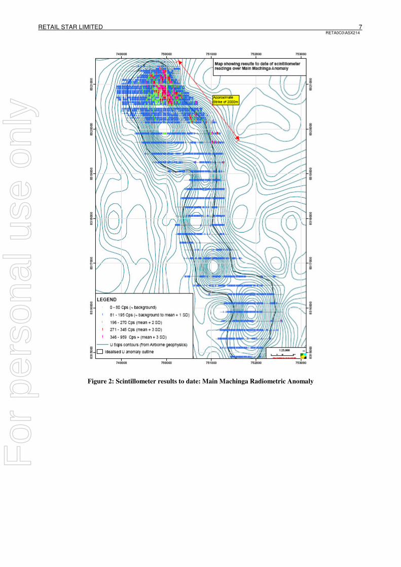
During the current phase of exploration, the entire strike length of the Main Machinga Anomaly has been covered by 200m spaced reconnaissance lines with a station spacing of 10m using a scintillometer instrument (to measure total radiation) (Figure 2). This has defined a zone of highly anomalous readings (over x3 background) trending NW/SE for over 2000m across the strike of the northern portion of the Main Machinga Anomaly, correlating well with the known position of the Kasupe Thorium prospect. This anomaly has a measured width upwards of 500m. Scintillometer readings from the southern portion of the Main Machinga Anomaly were less anomalous, but still interesting zones of at least twice background that will require selective infill surveying and detailed geological reconnaissance.
1 The Geology of the Zomba Area; Malawi Geological Survey Bulletin No. 16; R. Boomfield, 1965
For
per
sona
l use
onl
y
RETAIL STAR LIMITED 3 RETA0C0\ASX214
Results from the Niton XRF Analyser indicate the northern portion of the Machinga Anomaly is highly mineralised with Niobium (Nb) and Zirconium (Zr). Uranium (U) responses were of a low tenor and are generally below 100ppm, with a peak of 352ppm. Tantalum (Ta) is currently being analysed in the field and results will follow. Samples will be sent to the ALS Chemex laboratory in South Africa over the following weeks for certified results. For comparison, Globe Metals and Mining’s Kanyika deposit (figure 1) has an Inferred Resource of 56.4 million tonnes averaging 2600ppm Nb2O5, 70ppm U3O8, 120ppm TaO2, 4800ppm ZrSiO4. (2600ppm Nb2O5
contains 1817ppm (0.18%) Nb; 4800ppm ZrSiO4 contains 2389ppm (0.24%) Zr.) Evaluation of the Northern Main Machinga Anomaly The detailed scintillometer surveys clearly highlight a significant anomaly which can be traced NW/SE for over 2000m with an approximate width of typically 200-500m. This is clearly associated with NW/SE striking bifurcating pegmatite zones, with individual zones exceeding 400-500m in strike length and up to 40m in mapped width. Such zones yield scintillometer (total count) readings typically 2 times background; but often upwards of 6-8 times background, with 959 counts per second (cps) the reported maximum figure (nearly 10 times background) Approximately 100 rock chip samples have been collected from this high priority area and ‘analysed’ using a portable handheld Niton XRF spectrometer for a broad suite of elements. Nearly all samples have been collected from pegmatite zones which were deemed to be mineralised. The following table indicates minimum, maximum and average values recorded for Nb, Zr, U and Thorium (Th).
Element No of samples Min (ppm) Max (ppm) Average (ppm)
Nb 97 11 15,394 1,695
Zr 97 17 62,370 10,901
U 97 < LOD* 352 31
Th 97 < LOD 9,640 647
* = limit of detection A number of infill detailed scintillometer lines still need to be completed, especially over mapped pegmatite occurrences and also to fully evaluate and constrain the apparent SE trending anomalies that step outside the airborne geophysical anomaly in the south east quadrant. Rock grab samples reporting 3615ppm (0.36%) Nb and 14525ppm (1.45%) Zr along with very high scintillometer readings provide much encouragement. The pegmatite zones are hosted within the basement gneisses and epidotised granites. Each pegmatite zone is made up of individual pegmatite veins ranging from 1 centimetre to 15 centimetres in thickness. It has been identified that the country rock sandwiched between each vein is mineralised as well, thereby significantly increasing the potential volume and therefore tonnage of any economic deposit. Pegmatite Styles located in the field and relationship to results Geological investigations have identified three different pegmatite lithologies which can be separated by their physical characteristics, geophysical response and mineralization style. While all are mineralised to varying degrees, one has significantly higher readings and will be targeted as the highest priority during the first drilling phase. There are zones where the pegmatites do not outcrop; though regolith, scintillometer readings of at least twice background and topgraphical indicators all point to underlying pegmatite zones (either new or continuations). Such zones will require targeted trenching and/or pitting to establish the orientation prior to drill planning.
For
per
sona
l use
onl
y
RETAIL STAR LIMITED 4 RETA0C0\ASX214
Drilling targets identified to date: Target 1 (Centered on 750,000mE / 8321,250mN) (Figure 3) This pegmatite zone corresponds to the zone mapped by Miller in 1955. It strikes NW/SE and can be traced for approximately 400m with an approximate cross strike width of 40m. Readings to date indicate a shallow dip of 35 degrees to the north east. First pass rock chip sampling reported a high of 0.4% Nb and 2.4% Zr. Subsequent sampling along the strike of the unit yielded 10 rock chip samples, 9 of which reported greater than 1000ppm Nb and included: Target1-2 1.08% Nb and 6.2% Zr Target1-5 0.4% Nb and 1.7% Zr Target1-6b 0.9% Nb and 3.3% Zr Target 2 (centered on 750,250mE / 8320,750mN) This pegmatite zone appears to be far better defined than mapped by Miller and more extensive in terms of strike and width. Although there are many mapped units within the target area, the principal zone can be traced for 200m and is up to 15m wide. Exposures in stream sections indicate shallow dips of 35
degrees to the east.
First pass rock chip sampling reported: MAOC10A 1.0% Nb and 1.1% Zr Line22-2 0.6% Nb and 5.0% Zr MAOC12 0.6% Nb and 2.9% Zr MAOC108 1.55% Nb and 2.7% Zr MAOC11 0.8% Nb and 1.5% Zr Subsequently sampling along the strike of the main unit yielded 5 rock chip samples, 4 of which reported +1000ppm Nb and included: Target2-1 0.3% Nb and 5.1% Zr Analytical Methodology (Niton XRF Portable Analyser) Sample Type: Rock Chip Samples Preparation: None - No qualified laboratory preparation facilities in the vicinity Instrument: Niton XRF Portable Analyser – XL3t (500) Method: Samples are ‘spot-analysed’ 3-4 times, yielding an average value which is reported Tantalum: The measurement process for Ta using the XRF analyser takes significantly longer
than other elements. Tantalum measurements are currently being taken Map coordinates are UTM:WGS84 Zone 36S
For
per
sona
l use
onl
y
RETAIL STAR LIMITED 5 RETA0C0\ASX214
The information in this report that relates to Exploration Results is based on information compiled by Mr Ian Scott, who is a Member of The Australasian Institute of Mining and Metallurgy. Mr Scott is a full-time employee of the Company and has sufficient experience which is relevant to the style of mineralisation and type of deposit under consideration and to the activity which he is undertaking, to qualify as a Competent Person as defined in the 2004 Edition of the “Australasian Code for Reporting of Exploration Results, Mineral Resources and Ore Reserves”. Mr Scott consents to the inclusion in the report of the matters based on his information in the form and context in which it appears.
For
per
sona
l use
onl
y
RETAIL STAR LIMITED 6 RETA0C0\ASX214
Figure 1: Malawi Geology & Project Locations
For
per
sona
l use
onl
y
RETAIL STAR LIMITED 7 RETA0C0\ASX214
Figure 2: Scintillometer results to date: Main Machinga Radiometric Anomaly
For
per
sona
l use
onl
y
RETAIL STAR LIMITED 8 RETA0C0\ASX214
Figure 3: Rock chip sample results (XRF) Northern Main Machinga Anomaly