ON THE INSTRUCTIONS OF In the Wyre Forest Local Plan Review - Preferred Opons Document (draſt) June 2017; the site has an allocaon for 56 units CIRCA 5.36 ACRES (2.17 HECTARES) FOR SALE RESIDENTIAL DEVELOPMENT SITE (Subject to Planning Consent) FORMER STOURMINSTER SCHOOL COMBERTON ROAD, KIDDERMINSTER DY10 3DX (For illustrave purposes only)
Transcript
ON THE INSTRUCTIONS OF
In the Wyre Forest Local Plan Review - Preferred Options Document (draft) June 2017; the site has an allocation for 56 units
CIRCA 5.36 ACRES (2.17 HECTARES)
FOR SALERESIDENTIAL DEVELOPMENT SITE
(Subject to Planning Consent)
FORMER STOURMINSTER SCHOOL
COMBERTON ROAD, KIDDERMINSTER DY10 3DX
(For illustr
ative purposes only)
L O C AT I O N
The Former Stourminster School is located off Comberton Road (A448) within a suburban area of Kidderminster. The site is bound to the south by Comberton Road, to the west by residential dwellings accessed from Comberton Park Road, to the north by sports fields associated with Comberton Primary School and King Charles I School and to the east by a small watercourse beyond which are arable fields. Kidderminster is a large town and civil parish in the Wyre Forest district of Worcestershire. It is located approximately 17 miles (27 km) south-west of Birmingham city centre and approximately 15 miles (24 km) north of Worcester city centre.
The site benefits from being located on the eastern fringe of Kidderminster, however it is still under 1 mile from the town’s railway station. Adjacent to a well-established and popular residential area with local shops, services and schools, the site is also located only a short distance from the Worcestershire countryside and picturesque villages of Stone and Harvington. This countryside feel of the site is enhanced by the presence of woodland and the Spennells Brook, part of which forms the eastern site boundary.
D E S C R I P T I O N
The site is circa 5.36 acres (2.17 ha) and currently occupied by several buildings associated with its former use as a school. The buildings are a mixture of brick built structures and portacabins. The gross internal floor area of the existing buildings is approximately 19,000 sqft (1770 sqm).
Vehicle access is gained from Comberton Road to the south and leads into a former car parking area which has pedestrian routes leading north around the old school buildings. A small tarmacadam courtyard is present centrally on site alongside a playground and several small soft landscaped areas. The south eastern area of the site is largely wooded, with mature trees and shrubs lining either side of the small watercourse. The site is not located within a floodplain, and the risk of flooding from rivers and the sea is recorded as ‘very low’, as classified by the Environment Agency.
F O R M E R S T O U R M I N S T E R S C H O O L , C O M B E R T O N R O A D, K I D D E R M I N S T E R
F O R M E R S T O U R M I N S T E R S C H O O L , C O M B E R T O N R O A D, K I D D E R M I N S T E R
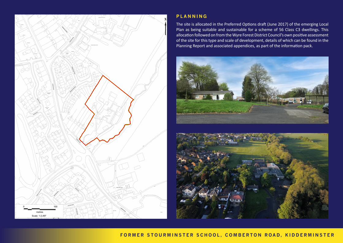
P L A N N I N G
The site is allocated in the Preferred Options draft (June 2017) of the emerging Local Plan as being suitable and sustainable for a scheme of 56 Class C3 dwellings. This allocation followed on from the Wyre Forest District Council’s own positive assessment of the site for this type and scale of development, details of which can be found in the Planning Report and associated appendices, as part of the information pack.
Former Stourminster SchoolComberton RoadKidderminster DY10 3DX
Place PartnershipUnit 2 Kings Court Business ParkCharles Hastings WayWorcester WR5 1JR Date: 17/05/2016
Nursery
COMBERTON ROAD
38.1m
15
Collects
13
COR
MO
R
10
2
DRIVE
Track
Track
Grain St ore
Wa ter W
h eel
The Hog House
The Sow Shed
3
The Pig Pen
1
Mea l H
ouse
SubEl
Sta
78
Heathy Mill Farm
Trac k
6
5
7
9
2
3
10
35
26
COMBERTON ROAD
63
73
39.0m
68
32
Wyre Forest School
BORR
INGTO
N R
OAD
46.0m
5
Comberton Primary School
Brookside Childrens Centre
13
15
11
8
MERLIN DRIVE
14
37
COMBERTON P
ARK ROAD129
9
12
33
36
13
19
8
CO
MB
ERTO
N PA
RK
RO
AD
4115 42
12a
1
2
LI T
TLE
GR
EB
E R
OA
D
1
1
MALLARD AVENUE
1
8
Tanglewood
2
46
CottageCherry Tree
3
El Sub Sta
BORRINGTON GARDENS
51
LB
51a
Chadstone
53
5
1
SPEN
NEL
LS V
ALLE
Y R
OAD
5
1
9
2
6
KINGFI
SHER G
ROVE
4
2
CO
MB
ER
TON
RO
AD
13
BungalowComberton Hall
Comberton Hall
18
Lodge
15
Stoneway
2a
BAR
NETTS C
LOSE
1
1 to 4
Issues
26
Sinks
8
46
2
4
47.9m
1
45.1m
Larches House
47
Half Acre
Wychwood
Little Oak
BURLINGTON CL
7
14
10
2
42
43
27
34
46
44
0 100
metresScale: 1:2,497
T E C H N I C A L DATA
Copies of the following supporting documents are available upon request by email to [email protected] and [email protected]. These include;• Planning Report - April 2018• Topographical Surveys - March 2018• Phase 1 Geo-Environmental Assessment - March 2018• Preliminary Ecological Appraisal - March 2018• Site Plans • Asbestos Surveys - May 2014/2016• EPCs
V I E W I N G
Viewing is strictly by appointment with the sole agent:
Important: These brief particulars have been prepared as agents for our clients and are intended as a convenient guide to supplement an inspection or survey. Their accuracy is not guaranteed. They contain statements of opinion and in some instances we have relied on information provided by others. You should verify the particulars on your visit to the property and the particulars do not obviate the need for a full survey and all the
appropriate enquiries. Accordingly, there shall be no liability as a result of any error or omission in the particulars or any other information given. May 2018. Design by Studio B61 www.StudioB61.com.
S E R V I C E S
Mains water, gas, electricity, drainage and BT are understood to be available to service the proposed development. However prospective purchasers are advised to make their own enquiries of the relevant providers.
T E N U R E
The site is to be sold freehold, with full vacant possession.