26
GIS Initiatives for The Strategic Development of The for The Strategic Development of The Eng. Abdulla Al Khaddeim Director of Project Management
GIS Initiatives for The Strategic Development of The for The Strategic Development of The
Eng. Abdulla Al KhaddeimDirector of Project Management

Int roduct ionInt roduct ion
• Fujairah is one of the seven members of U.A.E.
• Population is 190,000 with growth rate of 6%.
• It has an area of about 1450 km².
• It is second largest bunkering port in the
World (after Singapore).
Due to the oil pipeline between Abu Dhabi Emirates & Fujairah
and due to many oil companies established their storage tanks in
Fujairah, it may soon overtake Singapore.Fujairah, it may soon overtake Singapore.
• Wadies, Mountains, Beaches, Ancient Forts make it an attractive tourist destination.
• Since Fujairah Emirates is covered with mountains and deep wadies, limited land is • Since Fujairah Emirates is covered with mountains and deep wadies, limited land is
available for urban / rural settlement.
© 2014. Fujairah Municipality 2

Emirate of Fuj airahEmirate of Fuj airahESRI Open Source
© 2014. Fujairah Municipality 3

Emirate of Fuj airah
• Fujairah Emirate is administered through two
Emirate of Fuj airah
• Fujairah Emirate is administered through two
major Municipalities: Fujairah Municipality &
Dibba Al Fujairah Municipality. There are about
36 Towns & Villages under Fujairah 36 Towns & Villages under Fujairah
Municipality and Dibba Al Fujairah
Municipality.
© 2014. Fujairah Municipality 4

Fuj airah Municipalit yFuj airah Municipalit y
• Mission Statement• Mission Statement
Sound infrastructure and environment as per the international standards
• Initiative• Initiative
To become outstanding in ServicesEffective in Planning and DevelopmentUse of Technology to Assist OperationsUse of Technology to Assist Operations
• Services
PlanningPlanningCommercial LicensingPublic HealthEnvironmental ControlPublic RelationsPublic RelationsResearch and Building Material Testing
5© 2014. Fujairah Municipality

Brief HistoryBrief History
• Fujairah Emirate started implement ing GIS since 1995 by making Orthophoto maps for entire • Fujairah Emirate started implement ing GIS since 1995 by making Orthophoto maps for entire
Emirate at an scale of 1:5000 & CI = 5 m. In subsequent years line mapping were made for
Fujairah Town, Dibba Town, Mirba and Qidfa at an scale of 1:1000 & CI = ½ m
• In 1996, there were continuous rains for 3 to 4 days with the result that numbers of villages
were flooded. One such village which was severely affected was Qurayya about 7 km from
Fujairah Town. It was decided to resettle the village at a new location. Orthophoto maps of Fujairah Town. It was decided to resettle the village at a new location. Orthophoto maps of
1:5000 & CI = 5 m with software like AutoCAD, Arc View, CAD Overlay GSX were used to plan
new township for 200 houses with hospital, schools, shops, channels for water flow from
surrounding mountains etc within 2 days. Qurayya is now a thriving village. So far GIS surrounding mountains etc within 2 days. Qurayya is now a thriving village. So far GIS
technology has been used for planning new towns, shops, roads etc.
• Now Fujairah Emirate has decided to create Geo-database with land records as the basis. • Now Fujairah Emirate has decided to create Geo-database with land records as the basis.
© 2014. Fujairah Municipality 6

Land AllotmentLand Allotment
• In Fuj airah Emirates, Towns / • In Fuj airah Emirates, Towns /
villages (depending on their
size) are divided into sectors
and each sector is divided into and each sector is divided into
blocks.
© 2014. Fujairah Municipality 7

Site PlanSite Plan
• Assuming that the land is • Assuming that the land is
allocated to a person, a site
plan is issued by the Lands
Department having validity Department having validity
of six months to one year.
RESIDENTIAL
© 2014. Fujairah Municipality 8
Specimen Temporary Site Plan Sheet

Site PlanSite Plan
MOSQUE + DU + ETISALATRES.COMMERCIALAGRICULTURAL
© 2014. Fujairah Municipality 9
MOSQUE + DU + ETISALATRES.COMMERCIALAGRICULTURAL
Specimen Temporary Site Plan Sheet

MilkiyaMilkiya
• After the construction has • After the construction has been made in the allocated parcel, another site plan is issued by the Lands issued by the Lands Department. In this Milkiyano. (Title Deed no) is no. (Title Deed no) is mentioned. With this the person has confirmed ownership of the land with ownership of the land with construction on it.
© 2014. Fujairah Municipality 10
Specimen Site Plan Sheet With Milkiya

GeoSpat ial DataGeoSpat ial Data• The two site plans mentioned forms the basis for creating
GeoSpatial Data.GeoSpatial Data.• Since existing maps available were old it was decided to
prepare new maps in 2011 - 2012 at an scale of 1:1000 and CI = 0.5 m for about 120 Sq Km covering Fuj airah Town, Qurayya, Mirba, Qidfa, Al Hayl Industerial Area & Town, Qurayya, Mirba, Qidfa, Al Hayl Industerial Area & Gisemmeri. These maps have been converted in to Shape file format. Utility layers for Etisalat, Electricity, Water, Sewerage pipeline and Gas pipeline has been created depending upon the information available with depending upon the information available with municipality and on site.
• In 2013 mapping of Dibba Al Fujairah Town and all the villages under Fujairah Emirates covering an area of 230 Km² has been completed.Km² has been completed.
• Also sections like Planning, Building, Survey, Lands, License and Sewerage are keeping their records pertaining to land. Creating a centralized Geo –Data Base will help to put all the information available with Base will help to put all the information available with these sections at one place.
© 2014. Fujairah Municipality 11
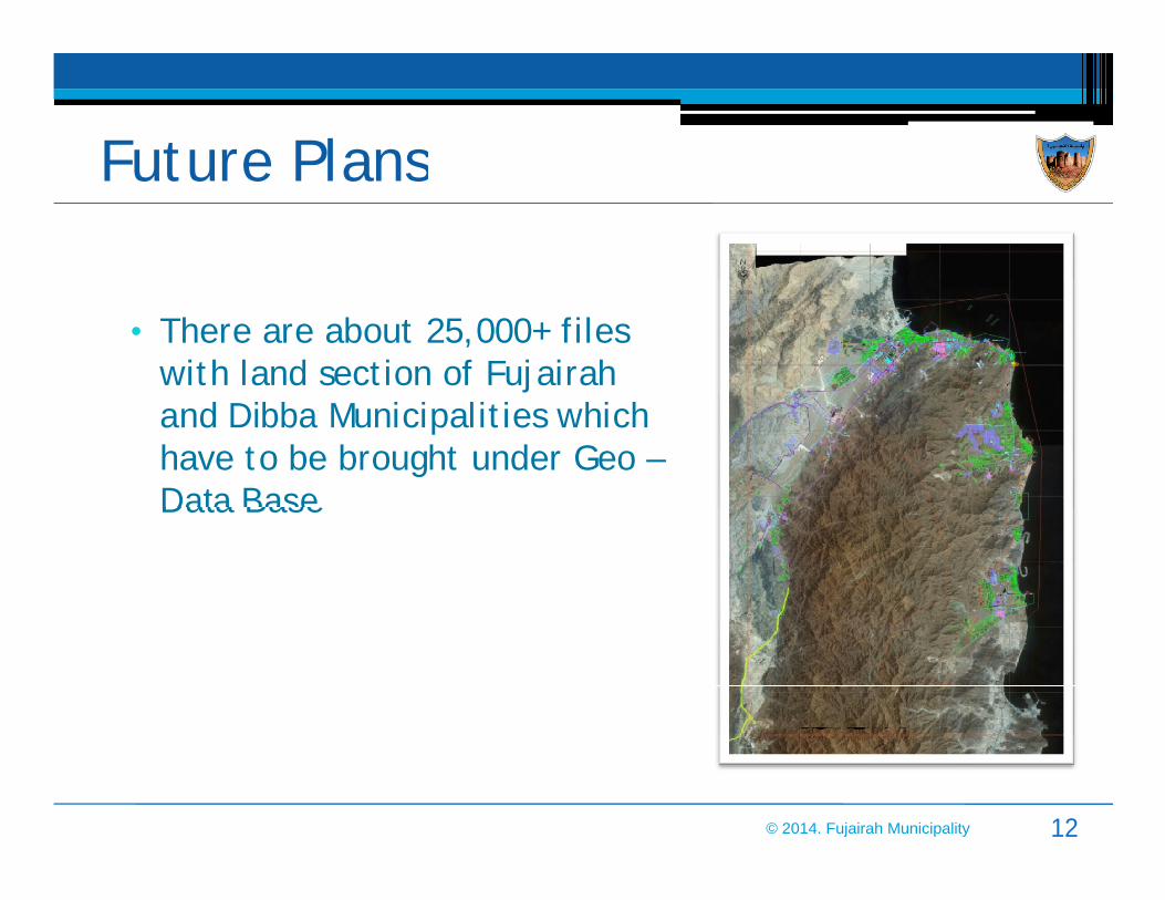
Future PlansFuture Plans
• There are about 25,000+ f iles with land sect ion of Fuj airah and Dibba Municipalit ies which have to be brought under Geo –Data Base.Data Base.
© 2014. Fujairah Municipality 12

GeoDatabaseGeoDatabase
• Geo database was designed so that parcel and owner informat ion • Geo database was designed so that parcel and owner informat ion available with Fuj airah Municipalit y is linked with map.
• Features are:• Features are:A. Search Module based on:
- Name of owner- Name of block- Name of block- Name of sector- Plot Number- National ID Number- National ID Number
B. View result as map & reportC. Language support English & Arabic.
© 2014. Fujairah Municipality 13
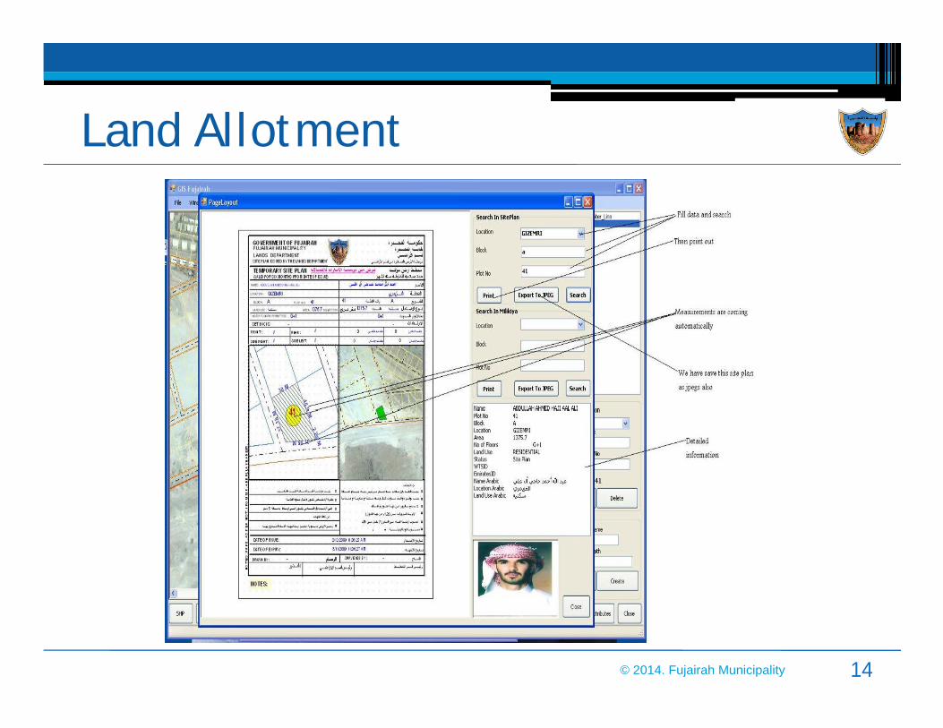
Land AllotmentLand Allotment
© 2014. Fujairah Municipality 14

Municipalit y DataMunicipalit y Data
• Data Components• Data Components
Orthophoto (15 cm Resolut ion)
Satellite Imagery (1m Resolution)
Landbase data (Building, roads etc)
Planning DataPlanning Data
Approved Site Plans
Approved MilkiyaApproved Milkiya
Owner Information
3D Geo-referenced Data Base3D Geo-referenced Data Base
© 2014. Fujairah Municipality 15

GIS DatabaseGIS DatabaseImagery, CAD /
Shape Files User 1Shape Files User 1
GIS Database1. Oracle Spatial
2. ArcSDE
User 2
Automation Tools
Local Network
User 3
© 2014. Fujairah Municipality 16

Data Migrat ionData Migrat ionRaw Data Migrated to GeoDatabaseAutomation Tools
Create New / Search / Browse Owner HistoryFinal Site Plan / Milkiya
© 2014. Fujairah Municipality 17

Data CenterData Center
• Fujairah Data Center Creation in Progress
• Central GeoDatabase
All Data in one place Web Based Edit CycleAutomation tools - Check-in and check-out CAD dataSite Plan and Milkiya AutomationSite Plan and Milkiya AutomationOwner Information Linked3D Geo-database linked
• Web Application –GeoServ• Web Application –GeoServ
Authentication & AuthorizationUser & User Group ManagementVirtual Map ServicesProfile based privilegesProfile based privilegesMap Layers Management
© 2014. Fujairah Municipality 18

Spat ial Data Infrast ructureSpat ial Data Infrast ructure
• Fujairah Data Center InternetInternet
DibbaMunicipality
General Public
• Fujairah Data Center• Management
Central Data Server for
InternetInternet
Permission Permission Scheme / Scheme /
Statistics Center
Other Government
Fujairah MunicipalityDibba MunicipalityFujairah Statistics Center
Central Data Management
Scheme / Scheme / Layer Access Layer Access
ControlControl
GeoServGeoServWeb Web Central Data Management
Permission Based AccessGenerate Reports, Statistics, Maps
• Benefits
Web Web Publishing Publishing SoftwareSoftware
• Benefits
Allow all agencies to access dataTrack / Monitor Changes in DataExpand to accommodate Public UsersCater to Future Growth in the Emirate
Central
GISExpand to accommodate Public UsersCater to Future Growth in the Emirate
19
GIS
Database
© 2014. Fujairah Municipality

VisionVisionData Sharing Public Access
Dibba Municipality Statistics Center Map Access
Fujairah Municipality
Other Government
Survey / Planning Statistics Data
Fujairah Municipality
Spatial Data
20
Spatial Data InfrastructureEmirate Wide Maps Verification / Control
© 2014. Fujairah Municipality

Onwani & MakaniOnwani & Makani
• Once the data base is completed in 2014 the Emirates will go for the
address system. Presently there are two approaches to this system:
ONWANI by Abu Dhabi Municipalit y & Makani by Dubai Municipality. It will ONWANI by Abu Dhabi Municipalit y & Makani by Dubai Municipality. It will
be a good idea to have one system for the whole of U.A.E.
21© 2014. Fujairah Municipality
• Fujairah Municipality decided to launch its Fujairah3D initiative in 2009
• Objectives1. To support the development of the Emirate with decision-making tools
for the leaders of Fujairahfor the leaders of Fujairah2. To create 3D virtual interactive applications on different topics for
decision-makers, citizen, investors, tourists.3. To build capacities of the 3D team of the municipality & educate the
stakeholders on the initiativestakeholders on the initiative
• BenefitsMutualization: one 3D virtual model (3D GIS database) for all usesMutualization: one 3D virtual model (3D GIS database) for all usesSustainability: building capacities & educationLarge diffusion: advanced technologies to target various publics locally and internationally
22© 2014. Fujairah Municipality

23© 2014. Fujairah Municipality

Gitex, October 2012 First Forum UAE planning diversity and integration, November 2011
National Day in City Center, December 20124th Gulf Tourism and Investment Forum, November 2012
24© 2014. Fujairah Municipality

Smart Fuj airah Smart Fuj airah
25© 2014. Fujairah Municipality

Thank YouThank You
Fuj airah Municipalit yFuj airah Municipalit yhttp://www.fujmun.gov.ae/
© 2014. Fujairah Municipality 26


