Forecasting the MJO with the CFS: Factors affecting forecast skill of the MJO over the Maritime Continent Augustin Vintzileos CPC/NCEP – CICS/ESSIC, University of Maryland College Park Jon Gottschalck CPC/NCEP
Transcript
Forecasting the MJO with the CFS:
Factors affecting forecast skill of the MJO over the
Maritime Continent
Augustin Vintzileos
CPC/NCEP – CICS/ESSIC, University of Maryland College Park
Jon Gottschalck
CPC/NCEP
Problem statement:
• Currently MJO can be successfully predicted for lead times between 2-3 weeks.
• The main reason which does not allow for more extended forecasts of the MJO is the Maritime Continent Prediction Barrier which is defined as a sharp drop in forecast skill as the enhanced convective phase of the MJO approaches the Maritime Continent. The skill becomes dependent on target time instead of lead time
• Is this barrier a forecast model problem or a predictability issue?
Outline…
• We first explore model issues with the CFS:– Model Resolution– Better Atmospheric and Oceanic Initial Conditions
• We then explore Predictability issues:– In Nature MJO events sometimes traverse and sometimes
collapse over the Maritime Continent– Is there a systematic difference between Traversing vs.
Collapsing observed MJOs? If yes, this would mean that the Maritime Continent Barrier is a forecast model issue and not a real predictability barrier.
Forecast model issues Atmospheric side
Higher horizontal resolution
Better initial conditions
Oceanic side
Better initial conditions
The atmospheric model side:
Model Resolution and Initial ConditionsCompare re-forecasts with the CFS initialized every 5 days from May 23 to August 11 from 2002 to 2006 at resolutions of:
T62, equivalent to 200km x 200kmT126 “” 100km x 100km T254 “” 50km x 50km
All resolutions are initialized by :
(1) Reanalysis-2 which is based on an older version of the GFS
(2) GDAS which is the operational analysis at NCEP (the best possible initial state)
Experiments performed on the CTB computer
Ocean resolution is constant and ocean initial conditions are from operational GODAS
Skill for the MJO mode (verification CDAS2)
Persistence forecast
GDAS
Reanalysis-2
GDAS
Skill up to 14 – 18 days
T62T126T254
Persistence forecast
30
The oceanic model side:
Initial Conditions
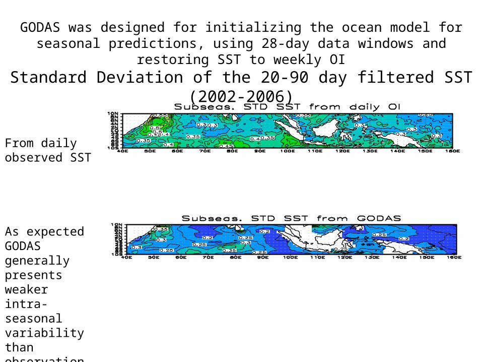
Standard Deviation of the 20-90 day filtered SST (2002-2006)
As expected GODAS generally presents weaker intra-seasonal variability than observations
GODAS was designed for initializing the ocean model for seasonal predictions, using 28-day data windows and restoring SST to weekly OI
From daily observed SST
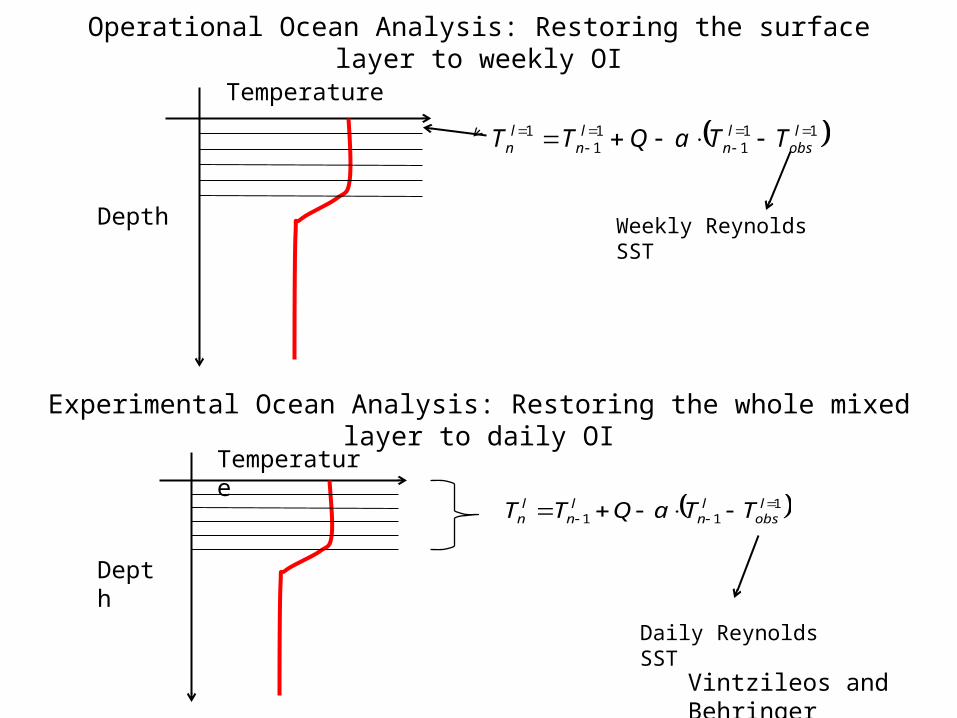
Operational Ocean Analysis: Restoring the surface layer to weekly OI
Weekly Reynolds SSTDepth
Temperature
111
11
1
lobs
ln
ln
ln TTaQTT
Depth
Temperature
111
lobs
ln
ln
ln TTaQTT
Experimental Ocean Analysis: Restoring the whole mixed layer to daily OI
Daily Reynolds SST
Vintzileos and Behringer
Comparison of operational GODAS (blue) with experimental GODAS (red)
The experimental GODAS clearly contains higher frequencies
42
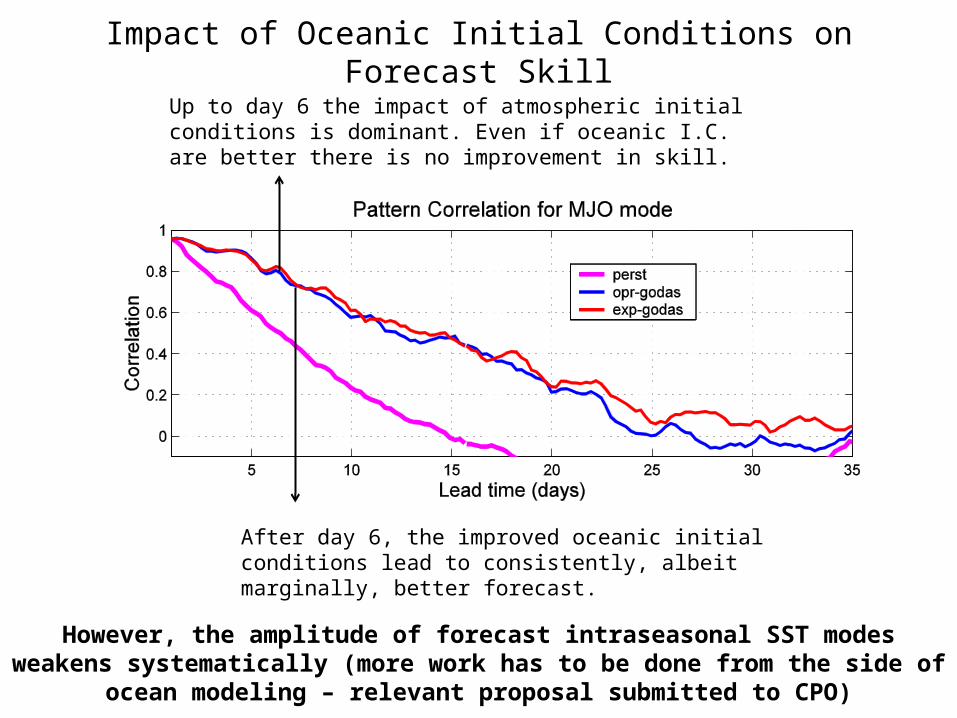
Impact of Oceanic Initial Conditions on Forecast Skill
Up to day 6 the impact of atmospheric initial conditions is dominant. Even if oceanic I.C. are better there is no improvement in skill.
After day 6, the improved oceanic initial conditions lead to consistently, albeit marginally, better forecast.
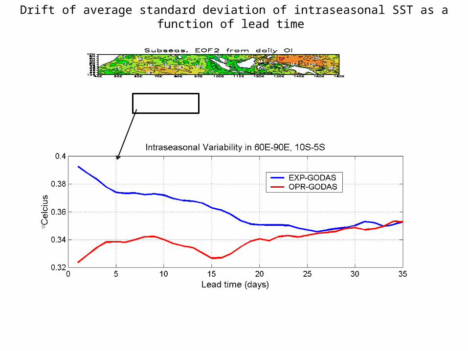
However, the amplitude of forecast intraseasonal SST modes weakens systematically (more work has to be done from the side of ocean modeling – relevant proposal submitted to CPO)
Drift of average standard deviation of intraseasonal SST as a function of lead time
Predictability issues
The Maritime Continent Prediction Barrier:
Observed MJO events may sometimes crash on the Maritime Continent
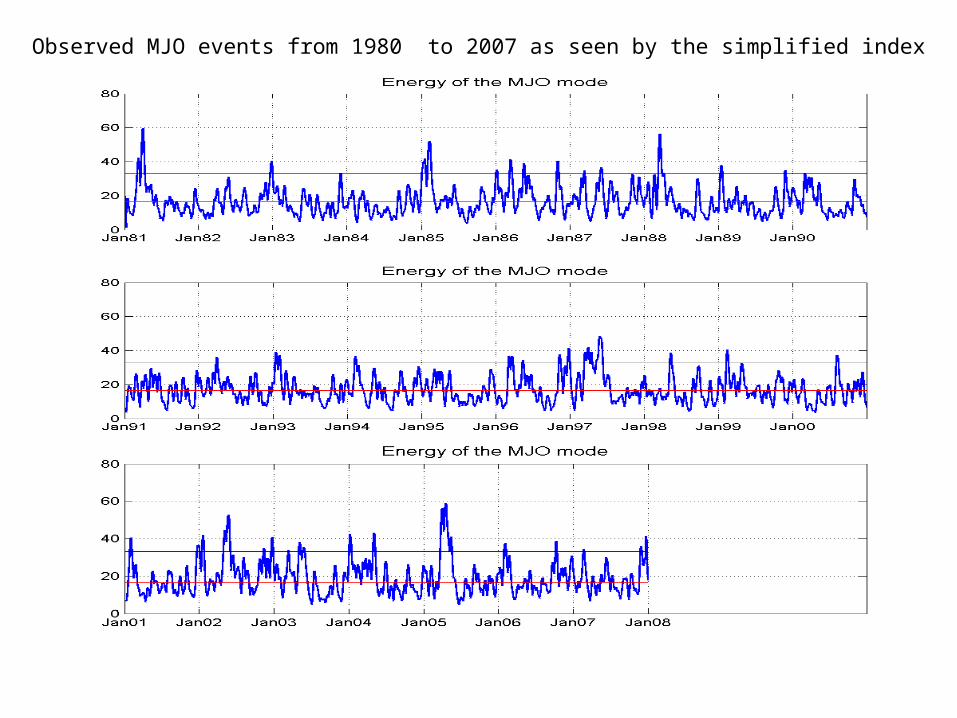
We classify observed MJO events in Traversing and Collapsing using the simplified MJO index from 1980 to 2007
We composite observed OLR anomalies
If the composites of traversing and collapsing events are different then we may conclude that the Maritime Continent Barrier is not due to predictability issues
Reconstruction of observed Traversing (January 1986) versus Collapsing (June 1982) MJO events
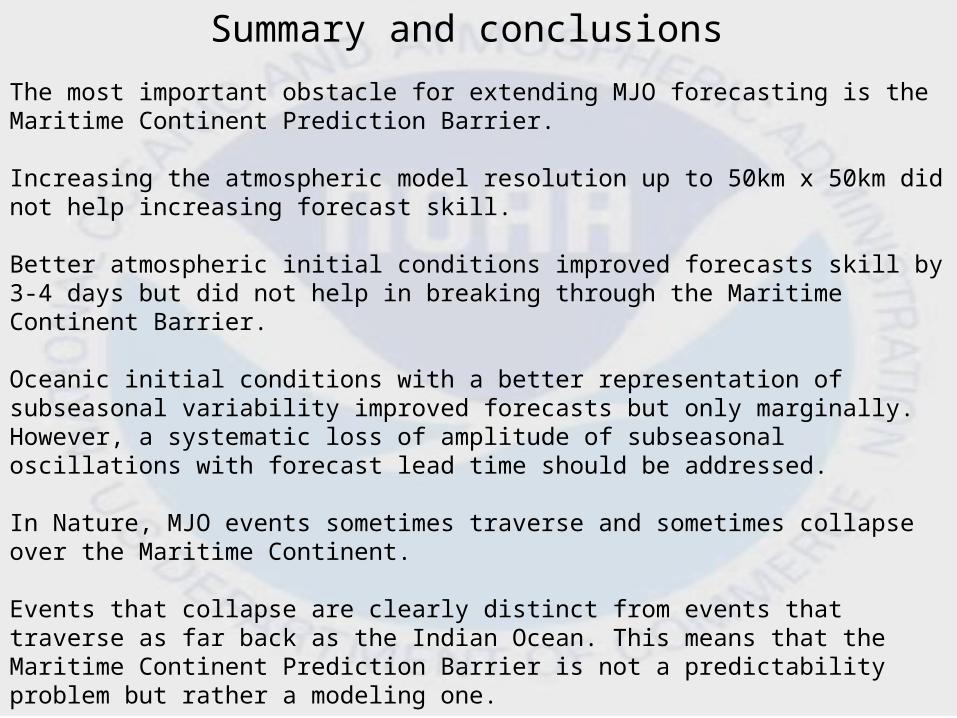
The most important obstacle for extending MJO forecasting is the Maritime Continent Prediction Barrier.
Increasing the atmospheric model resolution up to 50km x 50km did not help increasing forecast skill.
Better atmospheric initial conditions improved forecasts skill by 3-4 days but did not help in breaking through the Maritime Continent Barrier.
Oceanic initial conditions with a better representation of subseasonal variability improved forecasts but only marginally. However, a systematic loss of amplitude of subseasonal oscillations with forecast lead time should be addressed.
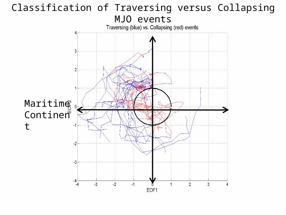
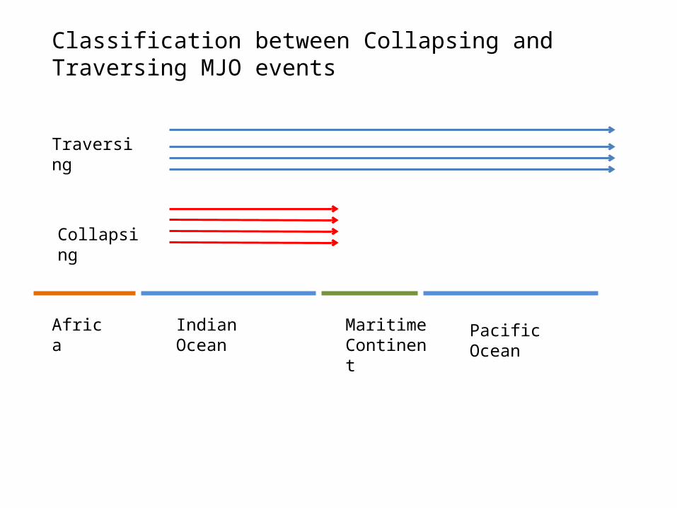
In Nature, MJO events sometimes traverse and sometimes collapse over the Maritime Continent.
Events that collapse are clearly distinct from events that traverse as far back as the Indian Ocean. This means that the Maritime Continent Prediction Barrier is not a predictability problem but rather a modeling one.
These distinct structures of traversing vs. collapsing events may be used by MJO forecasters.
Actions
We are participating to the DYNAMO campaign in the Indian Ocean which targets to observe atmospheric and oceanic processes relevant to the MJO
This participation is through a number of proposals submitted to the Earth System Science program element of the Climate Program Office
-- Provide real time monitoring and forecast to the campaign
-- Use DYNAMO and other data to investigate oceanic processes that are relevant to the MJO and provide model improvements for the next version of the CFS
-- Investigate the role of convective momentum transport
-- Monitoring of convective activity
Collaboration between: NCEP, CICS/ESSIC/UMCP, COLA, University of Miami and UCLA
A simplified Wheeler – Hendon MJO index
First and second EOFs of the zonal wind
EOF1 EOF2 -EOF1 -EOF210 daysr=0.6
A full oscillation in 40 days
Indian AtlanticPacific
Quantifying MJO through a simplified version of the Wheeler – Hendon CLIVAR index
Consider zonal wind at 200 hPa from Reanalysis-2, average between 20°S-20°N and then remove annual mean, zonal mean and ENSO (when necessary)
5S-5N averaged, total unfiltered precipitation field
20S-20N averaged, filtered U200 anomaly field
Upper level divergence
Reconstructed U200 vs. GPCP Precipitation, May – July, 2002
time
What is the Maritime Continent Prediction Barrier?
Forecast Skill of the CFS as a function of:
(x) initialization day (May – June 2002) and
(y) lead time
– Reforecasts for summers from 2000 to 2005
June 6th-9th
5S-5N averaged, total unfiltered precipitation field
20S-20N averaged, filtered U200 anomaly field
Upper level divergence
Reconstructed U200 vs. GPCP Precipitation, May – July, 2002
June 8th
Special case of first event in 1981 as viewed by the simplified index
Maritime Continent
Indian Ocean
Classifying strong Indian Ocean events that collapse over the Maritime Continent versus events that are traversing
Maritime Continent
σ
Indian Ocean
Maritime Continent
Classification of Traversing versus Collapsing MJO events
Observed MJO events from 1980 to 2007 as seen by the simplified index
Indian OceanAfrica Maritime Continent
Classification between Collapsing and Traversing MJO events


![Caso 2: CISTITE INTERSTIZIALE · ESSIC (International Society for the Study of Interstitial Cystitis) proposal. Eur Urol 2008;53:60–7] DEFINIZIONE ESSIC (2008) Rappresenta un concetto](https://static.documents.pub/doc/80x56/60683808a2d69b1686655846/caso-2-cistite-interstiziale-essic-international-society-for-the-study-of-interstitial.jpg)
