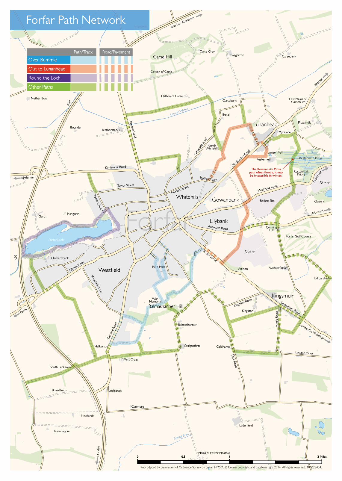
Welcome to Forfar Path Network Forfar lies in the heart of Angus, surrounded by the rich farmland of Strathmore. One thousand years ago Strathmore was a vast inhospitable area of bogs, lochs and scrub, and Forfar was one of the few crossing points. It was an important residence of Scottish Kings, with a Royal Castle on the shores of Forfar Loch. Forfar became a Royal Burgh in the 12th century but remained a small town until the 17th and 18th centuries, when farming expanded and huge quantities of flax were produced. Osnaburg cloth from Forfar’s mills was exported to America and the West Indies. The paths in this leaflet are a great way to explore the countryside around Forfar. Out to Lunanhead Over Bummie Balmashanner Hill or ‘Bummie’ dominates the skyline This route explores the countryside to the east of south of Forfar. A network of paths link the old slate Forfar and passes Lunanhead village. More adventurous quarries on the hill, offering some reasonably energetic walkers can extend the route to visit Restenneth Priory and cross Restenneth Moss, but should be aware that walks with views over the town. the path over the Moss is wet and muddy underfoot, Distance: 2-3 miles (3-5 km) round trip, depending and that it is often impassable during the winter months. on start point. Distance: 4 miles (7 km) round trip. Approx time: 1 – 1 1 / 2 hours. Approx time: 2 hours. Start: Reid Park, Dundee Road or Start: Whitehills. South Street. Terrain and accessibility: Mainly grass/earth paths and Terrain and accessibility: Hard surfaced paths and tracks, which may be rutted or uneven in places. Some tracks, rough in places. Steps at Reid Park entrance. roadside pavements. Gentle slopes. Kissing gates Some fairly steep slopes. No gates or barriers. between South Street and Arbroath Road. No other gates or barriers. Other paths The map shows other signposted paths around Forfar. These paths will let you link together the above routes, or make up your own circuit to explore the countryside around Forfar. You can find anything from a half hour stroll to a half day ramble. Round the Loch Forfar Loch is a Country Park, preserved for recreation and wildlife. The path around the loch is an easy circular walk and a great way of seeing the wildlife. Distance: 2 1 / 2 miles (4 km) round trip. Approx time: 1 hour 15 minutes. Start Forfar Leisure Centre. Terrain and accessibility: Hard surfaced paths. Fairly level. No gates or barriers.
Transcript
Forfar PathNetwork
Angus Path Networks
A92
A92A91
A92
A92A90
A90
A94
A90A9
A9
Montrose
Arbroath
Forfar
Perth
Carnoustie
DunkeldBlairgowrie
CouparAngus
KirriemuirBrechin
St Andrews
ANGUS
Monifieth
Dundee
Useful Information
Arbroath Tourist Information Centre01241 872609
Meffan Museum & Tourist Information Point01307 464123
Forfar Library01307 476476
Ranger Service, Forfar Loch Country Park01307 461118
Traveline (Public Transport Information)
www.travelinescotland.com 0871 200 22 33
The content of this publication can be made available in alternative formats or translated into other
community languages.
Leaflets are also available for path networks in otherparts of Angus.
Please contact the Council’s ACCESS Line on 08452 777 778 for further information
Wherever possible, barriers such as stiles andsteps have been avoided, to make paths asaccessible as possible to all users, includingdisabled people, cyclists and horseriders. Path surfaces vary from firm purpose builtpaths to farm tracks and earth paths. Furtherdetails are included in the walk descriptions.
Many of the paths are on working farms andestates. Please respect land managementoperations, take your litter home and keepyou dog under proper control.
Welcome to Forfar Path Network Forfar lies in the heart of Angus, surrounded by the rich farmland of Strathmore.
One thousand years ago Strathmore was a vast inhospitable area of bogs, lochs and scrub, and Forfar was one of the few crossing points. It was an important residence of Scottish Kings, with a Royal Castle on the shores of Forfar Loch. Forfar became a Royal Burgh in the 12th century but remained a small town until the 17th and 18th centuries, when farming expanded and huge quantities of flax were produced. Osnaburg cloth from Forfar’s mills was exported to America and the West Indies.
The paths in this leaflet are a great way to explore the countryside around Forfar.
Out to LunanheadOver Bummie
Balmashanner Hill or ‘Bummie’ dominates the skyline This route explores the countryside to the east of south of Forfar. A network of paths link the old slate Forfar and passes Lunanhead village. More adventurous quarries on the hill, offering some reasonably energetic walkers can extend the route to visit Restenneth Priory
and cross Restenneth Moss, but should be aware that walks with views over the town. the path over the Moss is wet and muddy underfoot,
Distance: 2-3 miles (3-5 km) round trip, depending and that it is often impassable during the winter months. on start point.
Distance: 4 miles (7 km) round trip. Approx time: 1 – 11/2 hours. Approx time: 2 hours. Start: Reid Park, Dundee Road or Start: Whitehills.South Street.
Terrain and accessibility: Mainly grass/earth paths and Terrain and accessibility: Hard surfaced paths and tracks, which may be rutted or uneven in places. Some tracks, rough in places. Steps at Reid Park entrance. roadside pavements. Gentle slopes. Kissing gates Some fairly steep slopes. No gates or barriers. between South Street and Arbroath Road. No other
gates or barriers.
Other paths
The map shows other signposted paths around Forfar. These paths will let you link together the above routes, or make up your own circuit to explore the countryside around Forfar. You can find anything from a half hour stroll to a half day ramble.
Round the Loch
Forfar Loch is a Country Park, preserved for recreation and wildlife. The path around the loch is an easy circular walk and a great way of seeing the wildlife.
Distance: 21/2 miles (4 km) round trip. Approx time: 1 hour 15 minutes. Start Forfar Leisure Centre. Terrain and accessibility: Hard surfaced paths. Fairly level. No gates or barriers.
Welcome to Forfar Path Network Forfar lies in the heart of Angus, surrounded by the rich farmland of Strathmore.
One thousand years ago Strathmore was a vast inhospitable area of bogs, lochs and scrub, and Forfar was one of thefew crossing points. It was an important residence of Scottish Kings, with a Royal Castle on the shores of Forfar Loch.Forfar became a Royal Burgh in the 12th century but remained a small town until the 17th and 18th centuries, whenfarming expanded and huge quantities of flax were produced. Osnaburg cloth from Forfar’s mills was exported toAmerica and the West Indies.
The paths in this leaflet are a great way to explore the countryside around Forfar.
Out to Lunanhead
This route explores the countryside to the east ofForfar and passes Lunanhead village. More adventurouswalkers can extend the route to visit Restenneth Prioryand cross Restenneth Moss, but should be aware thatthe path over the Moss is wet and muddy underfoot,and that it is often impassable during the winter months.
Distance:4 miles (7 km) round trip.Approx time:2 hours.Start:Whitehills.
Terrain and accessibility:Mainly grass/earth paths andtracks, which may be rutted or uneven in places. Someroadside pavements. Gentle slopes. Kissing gatesbetween South Street and Arbroath Road. No othergates or barriers.
Other paths
The map shows other signposted paths aroundForfar. These paths will let you link together theabove routes, or make up your own circuit toexplore the countryside around Forfar. You can findanything from a half hour stroll to a half day ramble.
Over Bummie
Balmashanner Hill or ‘Bummie’ dominates the skylinesouth of Forfar. A network of paths link the old slatequarries on the hill, offering some reasonably energeticwalks with views over the town.
Distance:2-3 miles (3-5 km) round trip, dependingon start point.
Approx time:1 – 11/2 hours.Start:Reid Park, Dundee Road or
South Street.
Terrain and accessibility:Hard surfaced paths andtracks, rough in places. Steps at Reid Park entrance.Some fairly steep slopes. No gates or barriers.
Round the Loch
Forfar Loch is a Country Park, preserved forrecreation and wildlife. The path around the loch is an easy circular walk and a great way of seeing the wildlife.
Distance:21/2miles (4 km) round trip.Approx time: 1 hour 15 minutes.StartForfar Leisure Centre.Terrain and accessibility:Hard surfaced paths. Fairly level. No gates or barriers.
Angus Path Networks steps have been avoided, to make paths as accessible as possible to all users, including disabled people, cyclists and horseriders. Path surfaces vary from firm purpose built paths to farm tracks and earth paths. Further Forfar Path details are included in the walk descriptions.
Network Many of the paths are on working farms and estates. Please respect land management operations, take your litter home and keep you dog under proper control.
Useful Information
Arbroath Tourist Information Centre 01241 872609
Meffan Museum & Tourist Information Point 01307 476482
Forfar Library 01307 476476
Ranger Service, Forfar Loch Country Park 01307 461118
Traveline (Public Transport Information)
www.travelinescotland.com 0871 200 22 33
The content of this publication can be made available in alternative formats or translated into other
community languages.
Leaflets are also available for path networks in other parts of Angus.
Please contact the Council’s ACCESSLine on 03452 777 778 for further information


![Russell, C., Forfar, L. C., Green, M., McGrady, J. E ... · FULL PAPER Probing the Structure, Dynamics and Bonding of Coinage Metal Complexes of White Phosphorus Laura C. Forfar,[a]](https://static.documents.pub/doc/80x56/5f068e057e708231d4189146/russell-c-forfar-l-c-green-m-mcgrady-j-e-full-paper-probing-the.jpg)


