Form-Based Codes A Primer for Delaware Municipalities Written By William J. DeCoursey, AICP, Associate Policy Scientist Tyler S. W. Berl, Graduate Public Administration Fellow Jeremy J. Rothwell, Graduate Public Administration Fellow Institute for Public Administration
Transcript
Form-Based CodesA Primer for
Delaware MunicipalitiesWritten By
William J. DeCoursey, AICP, Associate Policy Scientist Tyler S. W. Berl, Graduate Public Administration Fellow
Jeremy J. Rothwell, Graduate Public Administration Fellow Institute for Public Administration
Form-Based Codes, A Primer for Delaware Municipalities
April 2014
Written by William J. DeCoursey, AICP, Associate Policy Scientist Tyler S. W. Berl, Graduate Public Administration FellowJeremy J. Rothwell, Graduate Public Administration Fellow
Design, Layout, and Editing bySarah Pragg, Policy Specialist Institute for Public Administration
Project Advisory TeamDelaware Office of State Planning & CoordinationDavid Edgell, AICPConstance Holland, AICPHerb IndenDorothy Morris
Delaware Department of TransportationRalph Reeb
Published by Institute for Public AdministrationSchool of Public Policy and AdministrationUniversity of Delawarewww.ipa.udel.edu
In collaboration withThe Delaware Office of State Planning & CoordinationThe Delaware Department of Transportation
Cover graphic is from the Bradenton, Fla. Form-Based Code Land Use and Development Regulations, a winner of the Driehaus Award from the Form-Based Code Institute.
Dear Delaware Local Governments:
I am pleased to present Form-Based Codes, A Primer for Delaware Municipalities. This document has been prepared in conjunction with the Institute for Public Administration at the University of Delaware.
Our office has been working with the University and DelDOT to research and promote a framework for “Complete Communities.” This framework includes guidelines for creating communities that encourage economic development, improve the quality of life for their residents, efficiently use fiscal resources, and minimize disruptions to the natural environment. Form-Based Codes are a novel new approach to land use regulation that can help communities achieve the goal of creating a Complete Community. Form-Based Codes can be used by a community to define urban form, increase predictability, and encourage economic development. While this new approach to land use regulation may not be right in every circumstance, it is a tool that is worth consideration in any community interested in downtown revitalization or master planning.
This document is intended to provide background on the concept and case study examples to help communities decide for themselves if Form-Based Codes are a good tool to help achieve the goals of a local comprehensive plan or master plan. We hope you enjoy this publication. Please do not hesitate to contact your circuit rider planner if you have any questions or if you would like to learn more about Form-Based Codes.
Sincerely,
Constance C. Holland, AICPDirector
FOrm-BaSeD CODeS – A Primer for Delaware Municipalities i
The Institute for Public Administration (IPA) at the University of Delaware joins the Delaware Office of State Planning Coordination (OSPC) and the Delaware Department of Transportation (DelDOT) in offering this resource, Form-Based Codes, A Primer for Delaware Municipalities, to the governments, volunteer planners, staff, and citizens of our state and municipalities as a part of the state’s ongoing Complete Communities initiative.
Delaware is home to some of the most historic, interesting, vibrant, and rich-with-character towns in the country. The state, towns, and counties have a solid history of planning for, and working toward, continued growth and prosperity while holding fast to that which is most important. Our town centers, our farmland, our scenic and natural areas: these are our inheritance to preserve.
Form-Based Codes offer a compelling alternative to conventional zoning. How should this area look and function? How may we create and enhance the sense of community we already so enjoy?
This document is the most comprehensive of three companion pieces on the topic that may be found on The Delaware Office of State Planning Coordination’s website: http://www.stateplanning.delaware.gov/information/publications.shtml.
Please also see our Delaware Complete Communities Planning Toolkit athttp://completecommunitiesde.org.
We sincerely appreciate the time, commitment, and support of the project advisory team and thank them for their invaluable input.
We hope our work will help Delaware local governments build livable and resilient communities while preserving the many characteristics that make each community unique, healthy, and prosperous.
FOrm-BaSeD CODeS – A Primer for Delaware Municipalities ii
Form-Based Codes – a Primer for delaware municipalities 1
“Form-based (FBCs) codes foster predictable built results and a high-quality public realm by using physical form (rather than separation of uses) as the organizing principle for the code. They are regulations, not mere guidelines, adopted into city or county law. Form-based codes offer a powerful alternative to conventional zoning.
Form-based codes address the relationship between building facades and the public realm, the form and mass of buildings in relation to one another, and the scale and types of streets and blocks. The regulations and standards in form-based codes are presented in both words and clearly drawn diagrams and other visuals. They are keyed to a regulating plan that designates the appropriate form and scale (and therefore, character) of development, rather than only distinctions in land use types.”
–Form-Based Code Institute
In simpler terms, a FBC’s primary concern is not land use (commercial, residential, industrial, etc.), rather how the resulting building or development looks, functions, and relates to the street or other public spaces. The idea was developed by leading
new-urbanist thinkers and practitioners and is highly context sensitive—meaning the code is intended to be adapted to particular communities and architectural styles. Like any code or ordinance, they have the force of law and are not mere suggestions. As with conventional, use-based zoning codes, they function in tandem with a subdivision/street standards code. Most notably, they’re highly graphic and visual.
According to the Congress for New Urbanism, the overall goals of FBCs are that:
• Neighborhoods should be diverse in use and population.
• Communities should be designed for the pedestrian and transit as well as the car.
• Cities and towns should be shaped by physically defined and universally accessible public spaces and community institutions.
• Urban places should be framed by architecture and landscape design that celebrate local history, climate, ecology, and building practice.
FBCs are a relatively new type of ordinance designed to gradually
bring about more connected, com-plete, appealing communities.
Source: The New Urbanism Blog
What is a Form-Based Code?
Form-Based Codes – a Primer for delaware municipalities 2
Nothing. The real question is, “What is regular zoning designed to do and what does it do best?” Regular zoning was designed to regulate types of land use. It was not initially intended to address how development and buildings look and function together. Form-based codes were designed to do this best.
Traditional zoning is commonly referred to as Euclidian zoning, from the 1926 U.S. Supreme Court decision involving Euclid, Ohio. The Village of Euclid, a suburb of Cleveland, adopted a zoning ordinance designed to prevent the town from being swamped by encroaching, unhealthy, industrial development. The property owner, Ambler Realty, argued that the regulation was unconstitutional, as it “took away” a portion of the property’s value. Overturning a lower court’s decision, the Supreme Court sided with the village, in large part because the regulations were not arbitrary and were seen in compliance with a municipality’s “police power,” to protect the health and welfare of its citizens.
Up until this time, few municipalities had zoning ordinances. The Supreme Court decision and
the 1926 Standard Zoning Enabling Act (SZEA), developed by the Department of Commerce and subsequently adopted by nearly every state gave towns and cities the right to “divide the municipality into districts of such number, shape, and area as may be deemed best suited to carry out the purpose of the act.” The same document described the purpose of the act as to “promote health, safety, morals, or the general welfare of the community.” In such the municipal planning department was granted the right to regulate building height and density as well as other aspects of property development based on the established zone the property fell under.
How then did an initiative with such noble and laudable intentions come to be seen as a leading factor in suburban sprawl and the decline of downtown U.S.A? There isn’t universal consensus.
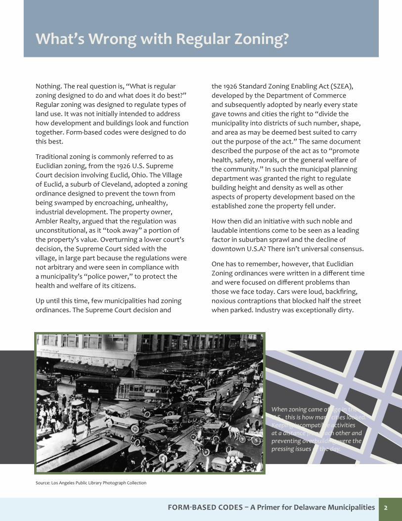
One has to remember, however, that Euclidian Zoning ordinances were written in a different time and were focused on different problems than those we face today. Cars were loud, backfiring, noxious contraptions that blocked half the street when parked. Industry was exceptionally dirty.
What’s Wrong with Regular Zoning?
When zoning came of age in the U.S., this is how many cities looked. Keeping incompatible activities at a distance from each other and preventing overbuilding were the pressing issues of the day.
Source: Los Angeles Public Library Photograph Collection
Form-Based Codes – a Primer for delaware municipalities 3
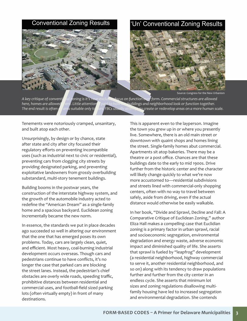
A key critique of conventional zoning is it’s near-exclusive focus on function over form. Commercial structures are allowed here, homes are allowed there. Little attention is paid to how the buildings and neighborhood look or function together. The end result is often an area suitable only to cars. FBCs usually attempt to create or redevelop areas on a more human scale.
Source: Congress for the New Urbanism
Tenements were notoriously cramped, unsanitary, and built atop each other.
Unsurprisingly, by design or by chance, state after state and city after city focused their regulatory efforts on preventing incompatible uses (such as industrial next to civic or residential), preventing cars from clogging city streets by providing designated parking, and preventing exploitative landowners from grossly overbuilding substandard, multi-story tenement buildings.
Building booms in the postwar years, the construction of the interstate highway system, and the growth of the automobile industry acted to redefine the “American Dream” as a single-family home and a spacious backyard. Euclidean zoning incrementally became the new norm.
In essence, the standards we put in place decades ago succeeded so well in altering our environment that the one that has emerged poses its own problems. Today, cars are largely clean, quiet, and efficient. Most heavy, coal-burning industrial development occurs overseas. Though cars and pedestrians continue to have conflicts, it’s no longer the case that parked cars are blocking the street lanes. Instead, the pedestrian’s chief obstacles are overly wide roads, speeding traffic, prohibitive distances between residential and commercial uses, and football-field sized parking lots (often virtually empty) in front of many destinations.
This is apparent even to the layperson. Imagine the town you grew up in or where you presently live. Somewhere, there is an old main street or downtown with quaint shops and homes lining the street. Single-family homes abut commercial. Apartments sit atop bakeries. There may be a theatre or a post office. Chances are that these buildings date to the early to mid 1900s. Drive further from the historic center and the character will likely change quickly to what we’re now more accustomed to—residential subdivisions and streets lined with commercial-only shopping centers, often with no way to travel between safely, aside from driving, even if the actual distance would otherwise be easily walkable.
In her book, “Divide and Sprawl, Decline and Fall: A Comparative Critique of Euclidean Zoning,” author Eliza Hall makes a compelling case that Euclidian zoning is a primary factor in urban sprawl, racial and socioeconomic segregation, environmental degradation and energy waste, adverse economic impact and diminished quality of life. She asserts that sprawl is fueled by “leapfrog” development (a residential neighborhood, highway commercial to serve it, another residential neighborhood, and so on) along with its tendency to draw populations further and further from the city center in an endless cycle. She asserts that minimum lot sizes and zoning regulations disallowing multi-family housing have led to increased segregation and environmental degradation. She contends
Form-Based Codes – a Primer for delaware municipalities 4
traditional zoning has warped the real estate market, dramatically increased infrastructure costs (longer roads, water, and sewer lines), and resulted in higher local taxes. Finally, she asserts that disconnected, cookie-cutter development has created soulless, unwalkable, and unwelcoming communities.
Whether one agrees wholeheartedly with Hall’s critique or not, many comprehensive plans in Delaware call for the preservation of that community’s unique, small-town character. Municipalities seek to revitalize their historic cores, bemoan the loss of a historic theatre and the old post office, and want to see a nice restaurant in a mixed-use area.
Perhaps the fairest criticism of Euclidian Zoning is simply that we don’t “build ‘em like we used to” primarily because the codes we’ve adopted do not allow for it.
Even so, towns and cities have striven to plan for and realize vibrant, walkable, picturesque, economically sound communities for decades. Almost invariably, the plans identify similar goals:
• To preserve small-town character
• To ensure new development is compatible with the existing community
• To revitalize or reinvest in the historic core
• To attract unique venues such as theatres or dining
• To enhance quality of life
Despite the considerable effort put into public meetings and visioning, mapping, plan writing, and zoning, municipalities aren’t entirely satisfied with the results. Though thoughtful planning is clearly very important, something has been lost in translation.
Source: Institute for Public Administration
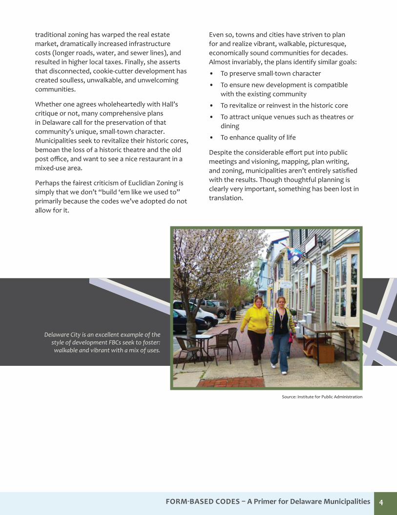
Delaware City is an excellent example of the style of development FBCs seek to foster: walkable and vibrant with a mix of uses.
Form‐Based Codes—A Primer for Delaware Municipali�es DRAFT 1/10/14
1
IntroductionForm-Based Codes (FBCs) are a relatively new, innovative way of addressing community design. Developed by new urbanists, FBCs are designed to be easily understood and heavily illustrated, sort of a picture book zoning ordinance. A well-crafted FBC should make life easier not only for your community’s building and development interests, but also for your citizen planners and town staff.
They can be used in any number of ways, from guiding a single new proposed development, directing the gradual re-development of targeted areas, or even the wholesale re-placement of existing, outdated zoning ordinances.
What are the potential benefits of a Form-Based Code? Since the advent of zoning, communities have tinkered with it, trying to achieve the best results. Mixed use, traditional neighborhood developments, planned unit developments, design standards. The list goes on. However, after one’s code has grown to several hundred pages with innumerable cross references, it begs the question; “Wouldn’t it be so much easier to take pictures of the types of development and redevelopment that are acceptable in particular neighbor-hoods, include easy to understand diagrams for parking, landscaping, and architecture for each neighborhood, and have that that be the backbone of a new, shorter, and easier to understand ordinance? That’s precisely the idea.
FBCs are geared towards achieving the connected, vibrant, walkable development with a variety of housing types and
businesses that so many communities desire. Obviously, turning one’s town into a “model” Complete Community would have many advantages—reduced air pollution, less traffic, families needing one fewer car, children able to walk to the park and school, higher property values and property tax revenues, and so on. Still, such transformations occur on a timescale of decades, not months or years.
There are, however, benefits to the FBC approach that are immediately evident. The process is an excellent opportuni-ty for community visioning/consensus building. Put simply, there aren’t very many wiggle-words in a picture. To apply a FBC to an area, the community needs to unify on what sort of picture to paint.
Community Visioning Developing a FBC is not like passing any run-of-the mill ordinance. Most FBCs will describe (street by street, block by block) the desired building form. A common approach is to identify areas in the community deemed desirable, physi-cally measure them, and use them as a guide for the FBC’s standards. This process in an excellent chance to engage the community so that all of the stakeholders in the community have a chance in deciding what the town will look like when it grows up.
Place-MakingFBCs can be applied in much higher resolution than stand-ard zoning. In a conventional code, there usually isn’t much difference between “Highway Commercial” in one part of town, as opposed to another. Because FBCs are the product of extensive visioning, more thought should be put into
FBCs are a rela vely new type of ordinance designed to gradu-ally bring about more connected, complete, appealing commu-ni es.
Delaware City is an excellent example of the style of development FBCs seek to foster, walkable and vibrant with a mix of uses.
Form-Based Codes – a Primer for delaware municipalities 5
FBCs can be valuable as finished products. Moreover, the process of creating them can be a tremendous asset to a community. A shared community vision about what type of place the community wishes to become is the primary benefit of the process itself. This is known as place-making.
A well-considered FBC should also be easier for residents and officials to understand, as it is heavily illustrated. It will clearly state what is allowed and preferred in a given area. Typically, FBCs employ a streamlined approval process. The hope is that by spelling out what is desired and then quickly approving compatible plans, increased economic activity will soon follow.
Community VisioningAny rezoning is an excellent opportunity to engage one’s citizenry in a public consensus-building or visioning process. However, since FBCs are extremely visual, full of graphics and pictures, and typically written in clear, concise, to the point language, they offer an excellent opportunity to create a shared vision of how the community would like to grow, what it wants to preserve, and more generally, what it wants to be when it grows up. Ideally, a community’s comprehensive plan would already spell out such a vision and a FBC would be used to help implement it in more exacting detail than conventional zoning would easily allow. In practical terms, however, a town seriously considering the time and investment required to produce a brand new, cutting edge ordinance would likely be better served updating its comprehensive plan concurrently. This would help ensure both documents mesh well together and would afford each the benefits of a considerable, and shared, public engagement process.
Place MakingAlmost without exception, every town wants to be a special, memorable place—either for its residents or its visitors. Everyone wants to live somewhere special and to be proud of their community’s assets. FBCs, by design, lay out different standards for various neighborhood types, allowing town officials and planners to tailor the code for the desired result area by area in their community. Creating a FBC almost always involves identifying the outstanding areas in one’s community; measuring and documenting the buildings, streets, open spaces, and architectural features; and, codifying these features to retain the neighborhood’s character. These observations are then translated onto the regulating plan just like preferred uses would be on a standard zoning map. If standard zoning were an industrial paint gun, a FBC would be an artist’s paintbrush, capable of much finer detail. Of course this can be applied to existing areas, or also to adjacent undeveloped areas the municipality would like to see built out in a compatible manner.
Prescriptive, not Proscriptive“A Legal Guide to Urban and Sustainable Development for Planners, Developers, and Architects”, by Daniel Sloane and Doris Goldstein makes the point perfectly. As a prescriptive code, FBCs lay out what the community wants to see. If the downtown consists primarily of two and three story neoclassical buildings fronting the street, that is what the code will say and show for that area. Conversely, traditional codes tend to be proscriptive—explaining only what is not permissible, in terms of building form and location. Zoning was developed as a means to prevent overbuilding, which it does quite well. For example, when there is a prohibition of buildings over five stories downtown, the town likely meant, don’t dwarf the other buildings, it won’t look right.
Should My Town Consider a Form-Based Code?
Form-Based Codes – a Primer for delaware municipalities 6
Unfortunately, this well-intended regulation would allow a one-story liquor store set 20 feet further back than the neighboring four-story buildings. It’s certainly fewer than five stories, but it looks equally out of place. A well-crafted FBC would simply state that buildings in this area are to be between two and five stories and will be within a similar distance from the street as the neighboring structures. Where a conventional code tells you what is prohibited, the FBC tells you clearly what is prescribed.
easy to UnderstandIf conventional zoning codes are a technical manual then form-based codes are a picture book. By their nature and design, they are much easier to understand. To be certain, they still have their complexities and intricacies, but the town’s vision for a particular area should be readily apparent, even to a relative novice. The saying “a picture is worth a thousand words” comes to mind, but it’s more than that. As noted above, it’s simply much easier to describe what a community wants to see than to describe dozens of scenarios that could lead to an undesirable result.
economic DevelopmentIn his article, “Economic Value of Form-Based Codes,” author Sam Newburg concludes that FBCs have economic value as well. While traditional zoning is often focused on preventing overbuilding, FBCs tend to seek the highest and best use for an area, be it a solitary parcel or a district. Also, FBCs tend to be less restrictive as to the uses allowed. In a Euclidian commercial district, a building may be restricted to certain lot coverage; and, though the code may allow for three stories, it can be difficult to find commercial occupants for the upper floors. Often, one can see how a smaller, one-story, commercial structure would be the “path of least resistance.” On the other hand, if in an appropriate area, a FBC would likely require greater lot coverage, more than one story, and allow for multiple land uses. The hypothetical result is a one-story strip commercial building versus a multi-story, larger, mixed-use structure. While not a cure-all, this is how FBCs could lessen the difficulty finding tenants for each floor. Because it’s not a commercial district, in an FBC arrangement, the upper floors could be residential, office, or both. Clearly, the FBC-driven
Just as no two communities are exactly alike, neither are any two FBCs. Each is tailored not only for its community, but for specific areas within the community. All good FBSc show the user the town’s vision with pictures and diagrams.
Neighborhood Retail Center (Medium to Larger scale buildings)Community Character Development (CCD) Overlay DistrictsCranberry Township - Butler County, PA
Legislative Intent:
29.1 Medium to larger scale retail stores are intended to be sized and positioned to create attractive and desirable Neighborhood Centers.
Design Guidelines:
29.2 Buildings shall be located along sidewalks to frame the Streetscape.
29.3 Medium to larger scale retail shall add value to a neighborhood and respect local character by making them proportional to traditional buildings through the use of narrower bays of twenty (20) to thirty-two (32) feet in width.
29.4 Medium to larger scale retail building types shall be edged with Liner Shops.
Boulevard Entrance and Ground-Floor Retail, Crocker Park, Westlake, OH
First Floor Shops and Condos Above Commercial, Crocker Park, Westlake, OH
Mixed Use Building, South Side Works, Pittsburgh, PA
Neighborhood Center Retail, Crocker Park, Westlake, OH
29
Source: Cranberry Township, Pa.
Form-Based Codes – a Primer for delaware municipalities 7
building will generate more economic activity, be appraised and assessed higher, and lead to increased property tax receipts for its jurisdiction.
The code also gives the new property and neighboring property owners certainty that their investments will not be depreciated by incompatible building types in the area.
Streamlined Development ProcessAnyone who has sat on a local planning board or town council has seen the occasional builder or developer become frustrated with the review process. Whether one views them as brave entrepreneurs, cowed by an onerous and drawn-out bureaucracy, or as profiteers trying to skirt regulations is irrelevant, the fact is that capital seeks a return on investment and time is money. While some may chaff at the additional requirements often inherent in FBCs, others may well rejoice at having the opportunity to build, by-right, in a considerably shorter time frame. Put simply, if the municipality has agreed upon a vision
and the private sector is obliged to cooperate, many FBCs will allow a staff-level, administrative approval to expedite the process and encourage more investment. Only when conditional uses, waivers, variances, or exceptions are sought would an applicant have to go through a more lengthy process. “Form-Based Codes: A Guide for Planners, Urban Designers, Municipalities, and Developers,” by Parolek and Crawford says it best: “One benefit of an FBC to the general community is the opportunity to create an overall vision considering all aspects of the built environment and then creating a prescriptive FBC to help with the implementation of the vision. By going through this intense effort prior to code adoption, the community may confidently reduce its constant watch over individual development proposals.… But the real value is the potential for administrative project approval. Including a process for administrative review can help convince developers to support the approval of the FBC, as well as encourage them to develop under it.”
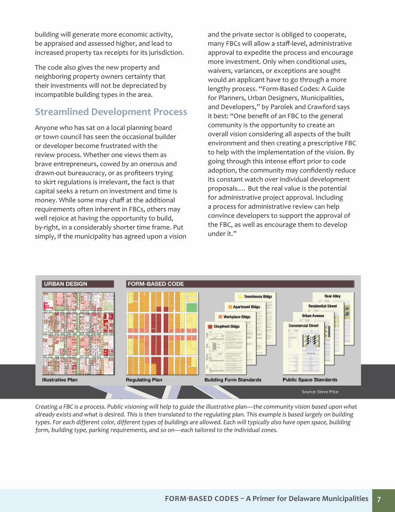
Creating a FBC is a process. Public visioning will help to guide the illustrative plan—the community vision based upon what already exists and what is desired. This is then translated to the regulating plan. This example is based largely on building types. For each different color, different types of buildings are allowed. Each will typically also have open space, building form, building type, parking requirements, and so on—each tailored to the individual zones.
Source: Steve Price
FOrm-BaSeD CODeS – A Primer for Delaware Municipalities 8
The shortcomings of traditional, Euclidian zoning have already been discussed. In summary, traditional zoning divides communities into single-use districts and generally attempts to establish uniform patterns of development for each use-district. Traditional zoning’s focus on dimensional constraints (setbacks, side yards, height) essentially creates a buildable envelope on a given lot, but says little about the building’s ultimate form or location within the buildable area. Essentially, it ignores the interface between the building and the street. Also, since they’re generally very uniform, many say they stymie innovation with a one-size-fits-all approach. Though they do prohibit wildly inappropriate development, they tend to prohibit quality design as well.
The vast majority of newer planning concepts and approaches from the past several decades have been, in large part, an attempt to work around these shortcomings.
Planned Unit Development (PUD)As traditional zoning codes became more complex and restrictive, Planned Unit Developments (PUDs) were introduced as a means to provide developers with more flexibility than was allowed under the jurisdiction’s established code. This form of coding allowed for the developer to negotiate with the planning department as to the regulations that would apply to a specific development project. The planning department is provided the ability to relax zoning regulation in return for stricter requirements in other areas, such as open space requirements.
The book, “Land Use Planning and Development Regulations Law,” by Juergensmeyer and Roberts defines PUDs as, “An area of land, controlled by a landowner, to be developed as a single entity for a number of dwelling units, and commercial and industrial uses, if any, the plan for which does not correspond in lot size, bulk, or type of
dwelling or commercial or industrial use, density, lot coverage and required open space to the regulations established in any one or more districts created, from time to time, under the provisions of a municipal zoning ordinance enacted pursuant to the conventional zoning enabling act of the state.”
In other words, a developer has a grand plan for a sizable parcel in or near town and wants to do a variety of things. However, if it’s zoned residential, he/she can build only homes, or if commercial, only stores. PUDs attempt to achieve more flexibility than would otherwise be allowed; to achieve a more “livable” environment; to encourage developers to be creative; to achieve more efficient use of the land; and to encourage a variety of uses and land use patterns, much the same as FBCs do. A common critique of PUDs though, is that they often fall short of creating truly mixed-use neighborhoods (where the buildings often serve several functions) and instead produce multiple-use developments. There may be commercial, residential, and civic uses, but they are often still separated spatially.
However, PUDs are generally only applicable to a single large parcel (typically a greenfield or brownfield) entirely under the control of a single entity. Unlike FBCs, they cannot be applied to an area that is already built out unless all the parcels are bought out by a single interest.
Traditional Neighborhood Development (TND)Like PUDs, Traditional Neighborhood Developments (TNDs) are custom codes that are administered as an alternative, when the entire property under development is under the control of one owner. They allow the developer to override the base zoning and generally encourage the building of connected, accessible, traditionally styled neighborhoods. The key difference
How do FBCs differ from more familiar concepts like PUDs, TNDs, or mixed-Use?
Form-Based Codes – a Primer for delaware municipalities 9
between TNDs and PUDs is the process. While PUDs are generally the result of a negotiating process between the developer and regulator, TNDs have by-right characteristics. Developers are typically entitled to smaller street widths, narrow lots, mixed uses, and parking reductions—both as incentives and as part of a package of design maneuvers intended to generate new neighborhoods that are as sustainable and desirable as historic ones.
Again though, TNDs are most readily applicable to greenfield developments or for redevelopment when a number of parcels are under the control of a single entity. There are instances where they can be applied as floating zones, but as such, a property owner would need to request that his/her property be rezoned into it. To be area-specific, a municipality would need any number of TNDs based on identified areas of differing character.
Cluster ZoningCluster zoning was an earlier attempt to curb urban sprawl and the consumption of open space. It was designed to allow for a pattern of development impermissible under traditional zoning and subdivision standards. In exchange for smaller minimum lot and yard sizes, developers agreed to preserve larger areas of open space by “clustering” the homes together. Cluster zoning is almost exclusively applicable to greenfield developments.
Design StandardsIn an attempt to make their communities more attractive and livable, many municipalities have adopted design standards or guidelines. Standards are typically mandatory, whereas, guidelines are optional. Compared to PUDs or FBCs, design standards tend to focus more on the building façade and appearance, architectural style, landscaping, windows, and awnings. However, they alone do not change a building’s underlying form. According to the Michigan Chapter of the American Planning Association, “The end result is usually aesthetically pleasing sprawl.” This criticism is based on the observation that few design standards address building use (to allow for mixed use), number of stories, placement adjacent to the street, and so on.
How are Form-Based Codes Different?Form-Based Codes, generally, aim to achieve the same goals as the above approaches. The key difference is that they attempt to do it comprehensively, all at the same time. Instead of applying various “patches” to existing zoning categories, the FBC replaces them (or the entire ordinance). In doing so, they try to be much simpler with far less cross-referencing.
Wouldn’t it be so much easier to take pictures of the types of development and redevelopment that are acceptable in particular neighborhoods and include easy-to-understand diagrams for parking, landscaping, architecture, and so on for each neighborhood? Use simple, everyday language, and cut perhaps up to 60 percent of the length out of you code? That’s essentially what a FBC does.
Adapted from Peter Katz and Steve Price, Urban Advantage
How zoning defines a one-block parcel
Density, use, floor-area ratio (FAR), setbacks, parking requirements, and maximum building heights(s) specified.
How design guidelines define a one-block parcel
Density, use, FAR, setbacks, parking requirements, and maximum building heights(s), frequency of openings, and surface articulation specified.
How form-based codes define a one-block parcel
Street and building types (or mix of types), build-to lines, number of floors, and percentage of built site frontage specified.
Form-Based Codes – a Primer for delaware municipalities 10
No two FBCs are alike. They can be implemented as a brand new code for an entire city, or act as the new base zoning for a particular district of interest, such as a town center.
Regardless, according to the Form-Based Code Institute and the aforementioned “Form-Based Codes: A Guide for Planners,” all will share a number of common elements, (described below) 1) a regulatory plan, 2) public space standards, 3) building form standards, and 4) thoroughfare/street standards. Most all will include a glossary of terms and a section detailing code administration and approval processes as well.
Many codes also address frontage standards, block and lot subdivision standards, building type standards, architectural standards, green building standards, and landscaping standards.
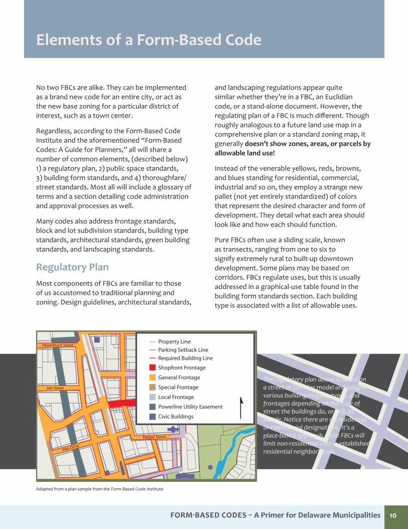
Regulatory PlanMost components of FBCs are familiar to those of us accustomed to traditional planning and zoning. Design guidelines, architectural standards,
and landscaping regulations appear quite similar whether they’re in a FBC, an Euclidian code, or a stand-alone document. However, the regulating plan of a FBC is much different. Though roughly analogous to a future land use map in a comprehensive plan or a standard zoning map, it generally doesn’t show zones, areas, or parcels by allowable land use!
Instead of the venerable yellows, reds, browns, and blues standing for residential, commercial, industrial and so on, they employ a strange new pallet (not yet entirely standardized) of colors that represent the desired character and form of development. They detail what each area should look like and how each should function.
Pure FBCs often use a sliding scale, known as transects, ranging from one to six to signify extremely rural to built-up downtown development. Some plans may be based on corridors. FBCs regulate uses, but this is usually addressed in a graphical-use table found in the building form standards section. Each building type is associated with a list of allowable uses.
Adapted from a plan sample from the Form Based Code Institute
elements of a Form-Based Code
The regulatory plan above is based on a street or corridor model and assigns various building heights, types, and frontages depending on the type of street the buildings do, or will, sit beside. Notice there are no residential or commercial designations. It’s a place-based approach. Most FBCs will limit non-residential uses in established residential neighborhoods.
Thoroughfare Standards
5́ 5́ 5́20́ 5́40́
Regulating Plan Building Standards and Forms
Open Space
Regulating PlanRegulating Plan
Shopfront Frontage
Required Building LineParking Setback Line
General Frontage
Special Frontage
Local Frontage
Powerline Utility Easement
Civic Buildings
Property LineHavenhurst Street
Jett Street
Pike Drive
Pepper Street
12
3
4 5
Form-Based Codes – a Primer for delaware municipalities 11
If a town doesn’t want to allow a certain type of use in a particular area, it can simply choose to not allow the building that would accommodate it.
Usually with regular zoning, areas where the town may not know what it would like to see in the future are most often zoned residential. It’s unclear exactly why, but any other designation risks making it difficult for a property owner to live on his or her own property. Visioning, community consensus, and careful planning are extremely important in FBCs because there is no longer the option of “residential by default.” Towns must know what they want, where they want it, and what they want it to look like in the future. There is much less “wait and see” because towns have already “seen” (through an extensive visioning process). The FBC seeks to help fulfill that vision.
Of course, any code can be changed and any parcel rezoned. A common fear of FBCs is “what if Apple or Disney suddenly want to locate a major employment hub in my town and the FBC doesn’t allow for the type of structure(s) they want?” In this regard, FBCs are just like any traditional Euclidian zoning or plan. When or if that happens, you tear up the offending parts of your FBC and work with the interested entity to adapt it… just like you would have with your regular zoning.
Public Space StandardsUsable open space, active or passive, is important for any community. Typically we think of public space as parks, playgrounds, or natural areas. FBCs do address these. However, since FBCs usually focus more on urban areas, the public right-of-way, street furniture, pocket parks, and tot-lots are more commonly addressed. Existing open spaces, such as playgrounds, will be indicated on the regulating plan. The FBC attempts to spell out what types of open spaces are desirable based on the setting, or the future desired setting. More rural areas would be most appropriate for golf courses, multi-field sports complexes, and the like. As one moves to more urban areas, naturally the scale of what is appropriate would shrink from playgrounds, to pocket parks, eventually to terraces or small plazas, so as not to break up the fabric of the area with vast open spaces.
Related to this, successful FBCs must take into account the most important public spaces of all, the street. As with public space standards, street standards vary depending upon the size, location, and function of a given street and will generally be more stringent in urban areas or along major roadways. Whereas a five-foot sidewalk may suffice nicely in a zone dominated by homes and schools, it would prove inadequate in a city center. These standards commonly deal with factors such as street design speed, lane width, crossing times, distances between blocks, sidewalks, bike lanes, on-street parking, curb types, planting strips, street trees, benches, and transit facilities.
In already built-up areas, these standards may be largely aspirational, especially if the existing street dimensions, construction, utilities, and right of way limitations are incompatible. Coordination with the state department of transportation (DOT) is critical on state-maintained roadways as adopting conflicting standards would accomplish little. Still, it’s important to lay down a reasonable marker as all streets will someday be repaired or replaced, particularly if the municipality works with the state and its metropolitan planning organization (MPO) to get important projects into the capital improvement plan.
Building Form StandardsAlong with the regulating plan, the building form standards are the backbone of any FBC. As the name implies, they regulate the form and location of buildings on a lot. As with public space standards, they will generally go from fairly relaxed to more detailed as one addresses more and more urbanized areas. Critical issues such as building height, front and side-yard setbacks, build-to lines, parking placement and design, frontage considerations (if not done separately), and, finally, allowable uses by building type or building story are addressed.
Thankfully, this is largely accomplished graphically. Typically, each transect, or each unique neighborhood zone, is assigned it’s own table illustrating allowable dimensions, uses, parking, etc. Building form standards are another area where the new urbanist goals of FBCs are clearly expressed. From rural to urban,
Form-Based Codes – a Primer for delaware municipalities 12
front-yard setbacks shrink and often go from being minimums to maximums. In many cases, build-to lines are established in downtowns and urban centers to provide continuity to the pedestrian. Similarly, building heights tend to go from maximums to minimums in the same way. Permissible land uses are also addressed quite differently. Often, in town-center areas, uses are floor specific. It’s rare to find a FBC that disallows residential in any district other than a special one (like a sports stadium). However, in downtown areas, residential is often not allowed on the ground floor. Depending upon the characteristics of the area, even offices may be relegated to upper stories to preserve an interactive, transparent street-level experience for pedestrians.
Surface parking is another key consideration that could easily be the subject of its own study. Though FBCs are generally respectful of existing
conditions, particularly documented existing conditions a community has stated it favors, parking remains an important consideration. The Form-Based Code Institute strongly favors rear-loading garages for residential-style buildings and rear or side surface lot placement of surface parking in any neighborhood or transect, again with the aim of preserving and enhancing the pedestrian realm. Where available, FBCs will almost always allow on-street parking to offset some portion of any surface parking requirements. Surface parking provisions tend to be stated in maximums to prevent oversupply.
Building frontage standards are also typically addressed within the building form standards, though they are sometimes given a separate section. Often, FBCs will require transparent windows on ground floor retail. FBCs define where fences are allowed, where outdoor arcades or dining are desirable, and where awnings should be the placed. In town centers or more commercial areas, they seek to avoid long blank walls, or dull, unchanging building materials from one building to the next. In more residential areas, they may mandate elevated first-floor windows for added homeowner privacy and safety.
Thoroughfare/Street StandardsStreet standards would typically only be combined with a FBC in a wholesale rezoning of a community or when coding for yet-to-be developed areas. In built-out areas, this would be addressed largely in the code’s public space/thoroughfare standards. They are essential; however, if a community is serious about growing and wishes to extend an existing, connected, gridded street system.
Equally important is to ensure that the municipality’s public space and thoroughfare/street standards are reflected in, and are consistent with, the streets and subdivision ordinance (be it a formal part of the FBC or not). It’s imperative that the standards and regulations in each are compatible. If your FBC insists on sidewalks but your subdivision ordinance does not require them, chances are you won’t see many built.
Where pictures are not adequate to convey the desired level of detail, schematics and diagrams are used. In this case, the Live/Work building type was modeled after traditional structures in Mount Holly, N.J.
Adapted from the Mount Holly Form-Based Code
Building Form Standards
Thoroughfare Standards
5́ 5́ 5́20́ 5́40́
Regulating Plan Building Standards and Forms
Open Space
Regulating PlanRegulating Plan
Shopfront Frontage
Required Building LineParking Setback Line
General Frontage
Special Frontage
Local Frontage
Powerline Utility Easement
Civic Buildings
Property LineHavenhurst Street
Jett Street
Pike Drive
Pepper Street
12
3
4 5
Suggested Building Elements
• Horizontal Breaks: vertical windows (1)
• Vertical Breaks: porches, awnings or overhangs (4), Offset roof line (2,3)
• Ground Floor: storefronts (5), awnings (4) or overhangs
Form-Based Codes – a Primer for delaware municipalities 13
Code Administration and Approval ProcessIn this regard, FBCs are much like traditional codes. The planning and/or zoning office reviews applications for conformity. Projects that are determined to be in compliance and are allowable by-right receive expedited approval. The planning department or citizen planning commission generally must review those seeking minor relief, such as a waiver. More complicated, non-conforming proposals may well have to go through a much more extensive process, possibly up to and including the board of adjustment or town or city council.
FBC advocates suggest as streamlined a review process as possible and often allow staff-level, administrative approval for conforming, by-right applications. They contend this efficiency may help win over the builder and developer community early in the process and that it may serve as an engine of economic development as word gets out that, “you can build here!”
This may or may not be feasible for smaller municipalities with little or no staff. However, the possibility of using applicant’s fees to fund a conformity review of applications by a town’s planning and/or engineering consultant may be one option.
Hypothetically—
Two years and three months ago, you (then newly elected mayor of a small town in Delaware), against considerable opposition, won over council and a reluctant staff and embarked on crafting a FBC.
It was an exhaustive process of public meetings, charrettes, and walking tours. To everyone’s surprise, most (if not all) of the community really came together and found a common vision. Just under two years after the process began, the ordinance passed with no objections and was well-received.
Unfortunately, today you’re sitting in court as the judge explains the ordinance is null and void, not on merit, but some technicality. What happened?
Notice, Notice, Notice…
One of the most common ways ordinances are struck down is simply on due process grounds, often notice, says sage attorney. State code requires 15-days notice published in an official newspaper for rezoning hearings. The county codes vary, but some are stricter. And don’t forget about your own town charter. It may have requirements too. Botch one, and all your hard work could be for naught. In one instance, a mere change in the agenda (not properly published in the newspaper) was adequate grounds for tossing an ordinance.
Do You Know Your Charter?
Three-out-of-five votes may suffice to pass an ordinance in council, but beware exhausting yourself running against the wind in the face of strong public opposition.
Know your charter, as many in the state allow for a referendum on zoning changes and additions.
Overlays are Well-Done
Better to say they’re cooked. Though widely acceptable in many states, in no less than five Delaware cases overlays were overturned based on the court’s interpretation of Title 22, Chapter 3, §302, “All such regulations shall be uniform for each class or kind of buildings throughout each district but the regulations in 1 district may differ from those in other districts.” Make the FBCI proud and just change the base zoning. Make sure it’s consistent with the comp plan, of course.
These tips were provided courtesy of one of Delaware’s leading land use law firms. Municipalities should make full use of their solicitors when developing or implementing their own FBCs.
Tips and Tricks from a Sage Land Use attorney
Form-Based Codes – a Primer for delaware municipalities 14
Optional ConsiderationsThe decision to include separate sections on frontage standards, building type standards, architectural standards, green building standards, and landscaping standards are largely a matter of preference. If a community enjoys a particular, historic architectural style, it may well choose to pursue architectural standards. Prominent FBC advocates sometimes caution against this approach unless a community has a particularly strong heritage, fearing requirements that are too strict could detract from a community’s vitality and diversity.
Frontage types (the style and character of the part(s) of a building facing the street) are addressed in the building form standards. They typically address the location of entrances, windows, awnings, etc. Similar to architectural standards, communities that have strong feelings about the uniformity, or unique character of their community’s facades, may wish to devote an entire section to frontages. The same cautions apply.
Building type standards may also be a consideration. Some experts consider them an absolute necessity, while others feel the topic is adequately addressed in the building forms standard section. They spell out, by name, what types of buildings are allowed across various zones or transects. Are duplexes or large apartments allowable where multi-family residences are permitted? Essentially, the idea is to be proactive. Have a ready-made list of preferred building types that mesh with the other code standards, rather than being approached by a builder and having to pick and choose, or try to alter, their stock offerings. Many FBCs favor these “in between” types of residential offerings as they offer a middle ground between the single-family home and a large-scale apartment complex. The code must specify that larger parcels (over two acres) be subdivided further to create additional blocks and block sizes appropriate to the scale of the desired type of development. Again, depending on the vision for the area, the code may call for a street system of alleys and minor arterials or boulevards and thoroughfares between.
FBCs place a premium on connectivity, so gaining several access points to the surrounding network is paramount. Once accomplished, the developer or builder is free to introduce lots and projects appropriate to the area’s transect or neighborhood classification.
In truth, subdivision and block standards appear to be, as of yet, not fully addressed in the FBC research, certainly not to the point where there is a standardized template. The Smart Code v9.2 (developed by leading new urbanists as a model template for communities to use in fashioning their own FBC) lays out a reasoned methodology. Still, for decades, subdivision and street standards have been directly related to fixed land uses (residential streets, commercial streets, etc.)
Existing Federal Highway Administration (FHWA) and state DOT street typologies and access permitting to state and federal highways has been, and will continue to be an issue, particularly when the local vision conflicts with a state-maintained roadway’s classified use. In many Delaware communities, “Main Street” is also a state route or highway, originally designed to move traffic, at speed, from point to point. As the town has grown up around it, this arrangement may become less and less desirable to the community. They may wish to see higher-quality, integrated and walkable redevelopment replace some of the bland highway commercial development. Unfortunately, each agency (the DOT and the town) may have different standards on sidewalks, setbacks, speed limits, access points, etc. This is less of an issue on local roads, but on a roadway built, maintained, funded, and controlled by a state DOT, only close cooperation will help both parties get on the same page.
FOrm-BaSeD CODeS – A Primer for Delaware Municipalities 15
Creating a FBC from scratch would be a significant undertaking, particularly if one desired to comprehensively rezone an entire community. A great deal depends on the approach chosen. The creation of a single FBC district for an adjoining greenfield, or simply to preserve a historic area may well be less burdensome. Still, the Form-Based Code Institute suggests ten essential requirements for a successful FBC:
1. Is the code based on a community-generated vision?
2. Was the code developed under an open participatory public process?
3. Are the physical boundaries of the code properly chosen at the scale of neighborhood(s), district(s), and corridor(s)?
4. Is the code organized on a regulating plan that assigns development intensity on a lot-to-lot basis?
5. Have all essential FBC ingredients been included?
6. Does the code regulate the form of the rights-of-way?
7. Is the code graphically clear?
8. Is the code easy to navigate?
9. Has the code been framed with the cooperation of all appropriate city departments?
10. If the code does not cover an entire jurisdiction, is it structured to allow for future geographic expansion?
These criteria suggest some of the preconditions necessary for a form-based code. Clearly, a municipality that already has a thoughtfully crafted comprehensive plan would have a significant advantage. Even so, moving away from a use-based approach would likely require updating said plan, likely in concert with the development of a FBC. A town wishing to craft a FBC also needs
to possess the willingness and wherewithal to engage in a rigorous public visioning process, down to the block level. Staff time and professional expertise are also clear preconditions. To address and develop the various elements of the FBC, municipalities would likely need to have highly trained staff, be willing to invest in training them, and/or contract with a consultant familiar with the field. The town attorney would also likely need to play a significant role. As they’re highly graphical, the town may wish to also contract with a graphic design professional.
Given the effort involved, it would obviously be highly advisable to make sure as early in the process as possible that the new code stands on solid legal ground.
Provisions of the Standard Zoning Enabling Act (1926) provide the state police power to regulate building for the purpose of “promoting health, safety, morals, or the general welfare of the community.” As discussed by Matt Lawlor, in his Form-Based Code Institute webinar “Legal Aspects of Form-Based Codes,” the SZEA make no reference to how municipalities designate districts or zones. It is only because use-based zoning was proven constitutional by the Supreme Court first that it gained prominence. The prevailing opinion
What is Needed for my Town to employ a Form-Based Code?
Form-Based Codes – a Primer for delaware municipalities 16
is that form-based districting is allowable under the SZEA as well, so long as they are consistent with the municipality’s comprehensive plan. To date no FBC has been overturned by the courts.
Lawler emphasizes the necessity of adding verbiage into the municipal’s comprehensive plan (and zoning ordinance and subdivision code, unless they’re being replaced entirely) to allow for form-based districting within municipal limits. This should include how the form-based code will interact administratively if the FBC
only acts as a single district or section within the wider municipality. It is also important that the descriptions of desired land use patterns in the comprehensive plan mesh well with the FBC to avoid legal challenges, though the ordinance would certainly be more detailed. Further, while the SZEA does provide for Form-Based Coding as a means of lawful zoning, some states have taken the additional step of adopting a specific state statute expressly stating FBC as an allowable form of zoning, so as to leave no doubt. Delaware’s state statue mirrors the SZEA.
Narberth Borough, Pa.—We Can’t Build it Like We Used To.
The Borough of Narberth came to an unfortunate realization recently. They can’t redevelop their community in any way consistent with the existing building forms and functions. Their zoning code doesn’t permit it.
A relatively affluent “Mainline” suburban community just outside of Philadelphia in Montgomery County, Pa., the borough’s population has decreased from 5,407 in 1950 to 4,233 in 2000. The borough has experienced a very minor population increase to 4,282 in 2010.
Officially incorporated for over 120 years, the community dates back to the late 1600s. It’s Narbook Park historic district was added to the national register ten years ago.
Suffice it to say, the community was largely built-out before the advent of contemporary zoning.
Fortunately for the borough, which does not have a staff planner, Montgomery County stepped in and provided extensive consulting expertise for extremely modest compensation, relishing the opportunity to gain expertise themselves.
The county planner detailed the public engagement process as extensive. The core group (which happily included planning commission members, council members, the borough manager, borough zoning administrator, and building inspector) met monthly for a year and a half and held several design workshops and a series of public meetings. They estimate over 100 residents attended, 30 regularly.
“Community members may not be fluent with the zoning code, but they do know what they like about the community, and what they want to see stay the same,” said the county planner. Using the Smart Code as a template, that’s exactly what the workgroup set out to do—macro and micro analyzing neighborhoods and building dimensions and turning a blank template into a blueprint for historic Narberth.
Narberth Borough, Pa. We Can’t Build it Like We Used To
Form-Based Codes – a Primer for delaware municipalities 17
There is no set answer. Towns must consider what is the most appropriate way for it to conceptualize or organize the code and how the community would care to implement it? These are the two questions that will most likely determine how to proceed. The answers will depend largely on the geography of the town, future growth considerations, community vision, and the size of the area in question.
For example, a new development on the edge of town could be addressed with a simple floating zone. A small town that expects to grow by 150 percent in 20 years time would likely opt for a total replacement and a mandatory code. A town comprised of several distinct neighborhoods might create a number of districts. A town heavily affected by streets and rail lines might opt for a corridor-based approach. Transects would be ideal for a town growing into adjacent greenfields.
ImplementationIn practice, there are innumerable approaches municipalities have used to implement their codes. Quite literally, no two are the same. Then again, no two cities are either. Just keep in mind that the most popular implementation models are just that—models.
According to the aforementioned “A Legal Guide to Urban and Sustainable Development for Planners, Developers, and Architect”, FBCs are typically structured as mandatory codes, as optional or parallel codes (typically overlays), or as floating-zone codes.
Mandatory Codes
Mandatory Codes are the most popular, according to the authors. A mandatory code could involve the wholesale replacement of the existing zoning and subdivision regulations with a simpler and more graphic land use ordinance (a true or full FBC) or it may not. In many instances the FBC districts are
simply incorporated into an existing ordinance as new zoning classifications, appear as such on an updated, Euclidian-style zoning map, and become the base zoning for the affected areas.
Typically, in the user-friendly spirit of FBCs, a separate FBC document is created to illustrate the new zone(s) requirements (see Elements of a FBC). In these instances, this type of mandatory code is referred to as a hybrid.
Optional or Parallel Codes
Optional or Parallel Codes are exactly what their name implies. They are established, typically as zoning overlays, in targeted areas, or rarely across an entire jurisdiction. There is no formal rezoning process unless a landowner or developer in an area covered chooses to opt in. However, once chosen, the parallel code becomes the base zoning for that parcel or area. There is some concern regarding ambiguity, or the seemingly arbitrary nature of the approach, but the methodology has essentially been borrowed from the PUD concept, which has enjoyed success for years. The authors suggests optional or parallel codes may be applicable where the political will to “take the plunge” is uncertain or where there is a political culture of strong property rights advocates. While optional, or parallel, codes lack any “mandatory” standing and may be overlooked or ignored, they have sometimes found success where the traditional approval process is so rigorous that builders find the certainty and expediency of the FBC more attractive despite the added restrictions. Arlington Virginia’s Columbia Pike Code is a noteworthy example of this approach.
Floating Zone Districts
Floating Zone Districts are developed without a specific area in mind. They are applied to an area that builders or developers may show interest in, usually a fairly large area owned or controlled by relatively few parties. Floating zone districts are
What Type of FBC is Right for My Town?
Form-Based Codes – a Primer for delaware municipalities 18
like PUDs, but instead of the development interest putting forth ideas and concepts, the town does so ahead of time. The floating zone FBC concept is somewhat complicated by the fact that floating zones are developed in a spatial vacuum. They don’t appear as a colored zone on the zoning map until they’re applied, so they’re somewhat generic compared to a FBC district painstakingly prepared for a known area. They can be developed in direct consultation and negotiation with the applying party. Alternatively, in some instances, modified standards can be written into the district before the municipality is even approached, signaling its interest in attracting developers or builders who are interested in new urbanist principles or, at least, a streamlined review process.
ConceptualizationAside from visioning, the most basic element of a FBC is the regulating plan. Imagine a blown up map of the entire study area is sitting on a large table in front of you and your team. What rationale will you use to assign different community character, building types, street standards, and frontages for various areas? Obviously, this will depend upon your overall goals, the realities on the ground (built-out versus growing rapidly). Is everyone content with the municipality’s urban form or does it need fine-tuning. Are you out of room but still face growth pressure, or are you trying to save what little greenbelt and agricultural surroundings you have?
As with implementation, the spectrum of examples is virtually limitless, but there are a handful of commonly used approaches. California’s Local Government Commission summarizes them well as 1) Transects, 2) Neighborhood, Districts, Corridors, 3) Street-Based Regulating Plan, and 4) Special Purpose Zones.
Transects
Since the advent of the Smart Code, the transect concept has, arguably, become the most popular. Areas are classified as T1 (extremely rural or undevelopable) through T6 (major city center) as well as special districts (SD) for uses and areas that defy urbanist classification (such as regional shopping malls, massive car dealerships, or professional sports stadiums). Depending upon the municipality’s goals, transects can be applied matter-of-factly—the whole town is pretty suburban, so T3 and T4—or aspirationally (i.e., These sensitive areas are starting to suburbanize, so classifying T1 and T2 may limit that and we can do better than strip commercial downtown, so T4 and T5 may encourage them to “grow up” over time).
Neighborhoods, Districts, Corridors
Neighborhoods, Districts, Corridors is probably the least abstract option. It largely recognizes existing conditions or areas of unique character and seeks to either preserve or enhance them. For example, a district might be put in place to preserve a
FBCs are designed to be much more graphic and intuitive than conventional zoning ordinances. The transect approach (above) is one way the code is rationalized. Areas can be zoned according to the existing or desired intensity of development.
Source: SmartCode V.9
Form-Based Codes – a Primer for delaware municipalities 19
historic “Little Italy,” or small, lakefront cottages. There may be a town center, business district, or development along a major transit corridor. These are simply identified and documented; then their dimensions, uses, frontages, and building types are documented in the code. If they’re perfect the way they are, excellent. Likely, at least some don’t conform to modern building, fire, and ADA codes and could use some revision for inevitable redevelopment. Maybe others would benefit from a wider variety of uses (to keep the sidewalks from rolling up at night in the business district). Either way, this conceptual approach is largely a recognition of current realities.
Street-Based Regulating Plan
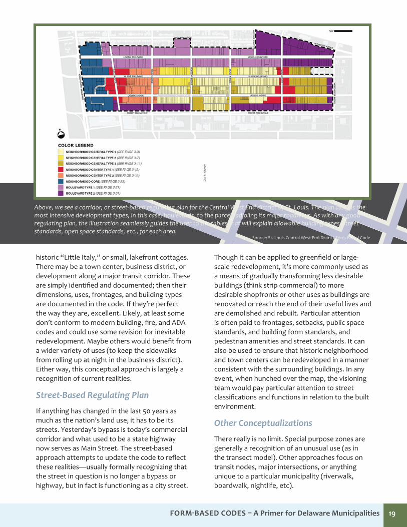
If anything has changed in the last 50 years as much as the nation’s land use, it has to be its streets. Yesterday’s bypass is today’s commercial corridor and what used to be a state highway now serves as Main Street. The street-based approach attempts to update the code to reflect these realities—usually formally recognizing that the street in question is no longer a bypass or highway, but in fact is functioning as a city street.
Though it can be applied to greenfield or large-scale redevelopment, it’s more commonly used as a means of gradually transforming less desirable buildings (think strip commercial) to more desirable shopfronts or other uses as buildings are renovated or reach the end of their useful lives and are demolished and rebuilt. Particular attention is often paid to frontages, setbacks, public space standards, and building form standards, and pedestrian amenities and street standards. It can also be used to ensure that historic neighborhood and town centers can be redeveloped in a manner consistent with the surrounding buildings. In any event, when hunched over the map, the visioning team would pay particular attention to street classifications and functions in relation to the built environment.
Other Conceptualizations
There really is no limit. Special purpose zones are generally a recognition of an unusual use (as in the transect model). Other approaches focus on transit nodes, major intersections, or anything unique to a particular municipality (riverwalk, boardwalk, nightlife, etc).
Above, we see a corridor, or street-based regulating plan for the Central West End district of St. Louis. The plan assigns the most intensive development types, in this case, boulevards, to the parcels adjoiing its major roadways. As with any good regulating plan, the illustration seamlessly guides the user to the tables that will explain allowable building types, street standards, open space standards, etc., for each area.
Source: St. Louis Central West End District Form-Based Code
Form-Based Codes – a Primer for delaware municipalities 20FOrm-BaSeD CODeS – A Primer for Delaware Municipalities 20
Pre-Phase 1: Scoping
Establish the Team
Because of the in-depth nature of the form-based code, having expert assistance in many areas including architecture, urban design, landscape architecture, traffic analysis, retail and housing spaces, and economic development is important. Further, because every FBC will differ depending on the characteristics of the jurisdiction implementing the code, so will the required expert team. Prior to the beginning phase it is important
to determine the core team that will be used, including existing staff, community volunteers, and hired consultants.
Select a Process
The planning process is the foundation for which the form-based code is to be created. As noted by authors Parolek, Parolek, and Crawford in “Form-Based Codes: A Guide for Planners, Urban Designers, Municipalities, and Developers,” the planning process has several very important purposes: “To identify and document the existing
How is a FBC Developed?
Most planners and local government types have heard of a nonconforming use—a property that predates the zoning ordinance or was rezoned and no longer meets the criteria. Sometimes it’s the last ranch home on a commercial thoroughfare or the repair shop between a development and the high school. They can stay so long as they’re in operation and don’t burn down, go vacant, try to significantly expand, or not pay their tax bill.
Over time, the situation usually resolves. FBCs can present a different scenario though… the nonconforming form.
What’s a planner or zoning administrator to do?
Hypothetical Scenario
The “mixed-urban” zone allows commercial, residential, and office. Meanwhile, a dumpy, one-and-a-half-story Tarot Card shop sits in the middle of it. The owner lives in the cramped loft upstairs. The uses comply to code, but it is set back 60 feet in a mixed-use area mandating four stories minimum! It’s next to impossible to condemn three feet of the oblong front yard to connect the sidewalk. How will this ever resolve?
The City of Bradenton, Florida adopted a FBC in 2011, and according to it, such a scenario is literally referred to as a pre-existing condition. Unlike a stingy insurance adjuster, Bradenton is
just fine covering this unfortunate malady. Rather than try to excise it, the city’s FBC seeks to improve it over time. Section 3.6 states the building is entitled to remain in its current use and form, vacant or occupied, until such time as it requests a substantial improvement. Break out the wrecking ball, right? Wrong. Bradenton’s code allows, by-right, substantial improvements that bring the structure into fuller compliance with the FBC. An addition here, an awning there, maybe a full second story?
With luck, maybe Bradenton’s code will set an example for how even buildings with serious pre-existing conditions can grow up big and strong.
Zoning or Health Care: What’s a Pre-existing Condition?
Form-Based Codes – a Primer for delaware municipalities 21
physical character of the area being coded; to engage the public in the exploration and review of alternatives to the existing physical character, usually through a charrette; to describe the preferred physical character of the different places within the coded area in illustrations that clearly show how the public realm and private development will appear if the community vision is implemented; and finally, to prepare a Regulatory Plan and draft the regulation.” In this stage, pre-phase one, it is the role of the planning staff to determine how the community visioning and other components of the public participation process will be configured. In Delaware, the creation of land development ordinances follows the comprehensive or master-planning process. Some towns may already have a plan that describes such a vision in adequate detail. However, if your community is serious about undertaking a FBC, it would probably make the most sense to update your plan with an eye toward it being fully FBC compatible first, or to do both together.
Determine the Application Area
It is important in pre-phase one to determine the specific area to be coded and the degree of change desired. This is accomplished, in large part, by taking into account results from the public-engagement process and the opinions of the expert team and speaks directly to the conceptual framework and implementation methodologies (discussed in the previous section).
Keep in mind also the degree of change that a community is looking to enact or willing to accept with the introduction of the code. The degree of change may be considered on a continuum from the least amount of change to the greatest amount of change in the area.
Determine the Implementation Method
Given the desired level of change, at this point one type of code may emerge as the leading candidate. Looking to preserve and enhance, you may consider a mandatory approach. If the town is trying to radically transform a blighted brownfield, one might consider a floating zone (see previous section for full discussion).
Phase 1: DocumentingThe first step when developing any form-based code is the documentation of the existing conditions within the community.
Because community character is so vital to the establishment of a useful form-based code, documentation needs to happen on two distinct levels: the macro scale and the micro scale. First, gaze at that big map on the table and get a general sense, then grab some markers, a camera, and a tape measure and tour the areas the group circled.
Macro Scale Documentation
Documentation on a macro scale allows the group to see the forest through the trees. What is the framework of neighborhoods, districts, and corridors within the community. The two major goals of this phase are to document the big-picture elements, enabling the group to create the Existing Framework Diagram that will become the basis for the Illustrative Plan and the Regulatory Plan. The Illustrative Plan is largely a visioning tool, a colored pencil mark-up of the areas in question. After refinement, it becomes the Regulatory Plan—a FBC’s version of a zoning map. These macro observations are crucially important. Once desirable areas are identified, the group begins to get into the nitty-gritty of what they like about it in particular: the building’s height, the street, the architecture, and so on.
Preservation of existing Conditions Preservation & enhancement evolution Transformation
LEAST CHANGE MOST CHANGE
Form-Based Codes – a Primer for delaware municipalities 22
Micro Scale Documentation
Whereas the macro was “big picture,” the micro scale documentation is a zoom in. The group had positive thoughts about several neighborhoods in the macro exercise? Great. How can they be duplicated elsewhere or preserved where they currently exist? What are the setbacks, heights, building types? What are the characteristics of the street, sidewalk, and lighting fixtures? How do some of these homes get by with less than three-car garages? What are the dimensional characteristics of all the present elements you plan to address in your FBC? That record plan was created in 1941. Chances are you’ll have to document everything if you hope to achieve it again.
Documentation on a micro scale provides the detailed measurements for the first draft of the FBC, which will then be modified during the visioning and coding phases. Documentation on this scale provides for an understanding of the common thoroughfares, civic spaces, building structures, and lot arrangements within the community. These micro-scale details will directly inform and become the content for many of the regulations within the various components of the code.
Clearly, it’s neither necessary nor feasible to measure every home and structure. Visiting representative samples is fine. By the end of the documentation phase, once everything is organized and tidied up, the team is ready to take its results to the public, if they’ve not been involved already. There’s a good chance many members of the community enjoy and appreciate some of the same areas the advanced team identified. Now, armed with reams of measurements, photos, and diagrams, the team is in a strong, informed position to engage the public in one of the liveliest public outreach activities planners and local government officials usually have the privilege of—the public hearing on the proposed comprehensive rezoning!
By the end of the documentation phase, the team will have the following products:
• Existing Conditions Base Map(s)
• Existing Framework Diagram, showing neighborhoods, districts, and corridors
• Existing Transect Matrix, showing the various transect levels
• Presentation boards for each micro-element sample, showing thoroughfares, civic spaces, frontage types, building types, and architecture styles—they typically include photos, maps, and measurement matrices
Phase 2: VisioningA critical component of the form-based code is the visioning process, as it ideally leads to the community agreed upon desired outcome for development, redevelopment, and possibly annexation. As stated by authors Parolek, Parolek, and Crawford a good vision has three characteristics:
1. It is a vision of a place the community really wants—after having a thorough understanding all the implications of the design.
2. It is detailed to a very refined level—much more refined than the visioning processes most communities and planners are familiar with from comprehensive or general plans.
3. It is implementable.
The product of the documenting phase will be used as the foundation for establishing the comprehensive community vision firmly in the code. This phase is done with a large amount of community input from experts and community stakeholders and is generally centered on the use of a charrette process. As noted by the authors, the charrette is beneficial for two main reasons:
1. A shortened visioning process (generally 4-7 days)
2. A mass-collaborative process that generates public momentum and support for the FBC
The visioning process is split into two phases, with the first focusing on the creation of the less-formal illustrative plan and ultimately the finalization of the regulatory plan (zoning map). This public outreach may or may not coincide with a community’s more general visioning and public engagement for the comprehensive plan. It just depends on what order things are done.
Form-Based Codes – a Primer for delaware municipalities 23
Generally, community-wide participation is solicited up front to determine, “What do we want our town to look like.” Determinations then move on to the specific when an ordinance is being crafted to realize the vision. At this point, the charette process is helpful (as opposed to public hearings or workshops spread out over months) because of the level of detail involved.
Phase 3: AssemblingParolek, Parolek, and Crawford reiterate the importance of adding verbiage into the municipality’s existing land use regulation to allow for FBC implementation in the jurisdiction. They call this “splicing.” They state:
“Unless the FBC is replacing the preexisting development code for the entire community or its being implemented under a PUD zone, the integration of form-based code standards into more extensive conventional code requires careful attention to the relationships between the standards and procedures in each code in the event that conflicts between them are perceived. The FBC will need to include one or more definitive statements to ‘splice’ the new FBC standards to those remaining in the preexisting development code, as well as to identify the circumstances under which either the preexisting code standards or the form-based code standards control for the purposes of the project design and/or review and approval.”
Equally important is establishing a strong, clear, and concise connection between the comprehensive town plan and any FBC.
As discussed previously, if at all possible the future land use map should show, and the plan’s text should describe, the affected areas and desired character and pattern of development.
The authors state that when assembling the code three assumptions must be made:
1. The reader is not familiar with the geographic area.
2. The user is not familiar with the community vision or the process that took place to create that vision.
3. A variety of users will be using the code. Some who understand textually, and some who understand graphically.
Assembling the code is basically just the process of laying it out, smoothing over any rough edges with additional, explanatory content, creating the graphics, charts, and tables, designing (as uniform as possible) page templates and transferring the content to the appropriate templates.
It may be advisable to utilize a consultant or graphic designer when creating and producing the final code. Producing graphics and publishing the final document so as to make it useable and easily understood can be a challenge. Simply, the technical and graphical demands are significant. If you’ve spent these many months (or years) working on the FBC, don’t get stingy at the end and risk all that effort looking anything less than spectacular on paper.
The Bradenton Form-Based Code includes this section to address the connection between the ordinance and the town’s other land use regulations.
APPLICABILITY1.5.1 General Applicability The provisions of these Form Based Code Regulations shall
apply to all development within the City within the Form Based Code Zone Districts. Affected parcels are designated on the Regulating Plan found in Article 13, Appendix A. No development shall be undertaken without prior approval and the issuance of the appropriate development order or permit pursuant to the applicable provisions of these Form Based Code Regulations, except as provided herein.
1.5.2 Provisions of this Code are activated by “shall” when required; “should” when recommended; and “may” when optional.
1.5.3 The provisions of this Code, when in conflict, shall take precedence over those of other codes, ordinances, regulations and standards except the Comprehensive Plan and Local Health and Safety Codes.
FOrm-BaSeD CODeS – A Primer for Delaware Municipalities 24
As useful as they can be, FBCs are not a magic wand. No matter how carefully your code is crafted, it will experience growing pains. There may be legal challenges, unanticipated conflicts with other state or county regulations, and citizen or political opposition from those who did not take part in the process. Experts caution that a town’s first FBC is likely to cost more to develop than a conventional zoning ordinance. However, a FBC is likely to cost less to administer over time.
According to the Local Government Commission, FBCs in particular, are prone to unanticipated hang-ups and glitches, precisely because they focus on character and not use. Despite your best efforts and outreach to other town, county, and state agencies, you may well find conflicts between your new FBC and entrenched state and local codes still based on land use. Fire codes, affordable housing regulations, environmental ordinances, even intergovernmental agreements from decades ago may, in time, present issues. Even once the code is completed, the work is just beginning. Any planners, staff, elected officials, developers, or engineers who were not involved in the process will have to be trained and acclimated to work with the code.
The FBCI adds these cautionary notes. You’ve gone through an exhaustive public engagement process. Of course, this will not stop all public scrutiny. There is always someone who didn’t get the memo, or decided not to become informed until the third reading of the adoption ordinance. Also, any new ordinance must anticipate the possibility of a legal challenge. FBCI advises involving your town solicitor in the process early and often. This brings up the issue of cost. Though not universal, FBCI estimates the initial comprehensive FBC rezoning may cost two to three times that of a conventional code update. Thankfully, this is largely a one-time big expense, as minor modifications or revisions should suffice for the immediate future.
The Michigan Chapter of the American Planning Association lists the following common mistakes they say many municipalities realize after the fact.
1. Thinking a Hybrid Approach is easier or more effective
Taken in context, they seem to be referring to “hybrid” as a parallel or optional code—something other than a mandatory, stand alone document, which would likely require less up-front work and investment. They note that municipalities sometimes go through significant effort only to have the code met with disinterest or apathy from the building and development community. Of course, as an optional code, that’s the end of the story. They also note that adopting a second land use ordinance (a FBC) without completely replacing the existing one means that current and future staff will have to be trained and competent in both.
2. Not refining Land Use TablesThe attachment to exhaustive lists of permissible uses can be a hard habit to break. It’s understandable that communities may be hesitant to make such a radical departure, particularly when concerns about “adult” and other nuisance uses are a legitimate concern (though easily addressed in an overarching statement). Unfortunately, insisting on listing every by-right, conditional, and prohibited use leads to FBC tables, and an FBC ordinance, that is unwieldy, long, and simply not the easy-to-read and understand ordinance it could have been.
3. Not Calibrating Open Space Requirements
Often more associated with the subdivision regulations than the FBC component, open space can be accidentally, or intentionally, overlooked.
The Fine Print—So, What are the Costs and Drawbacks?
Form-Based Codes – a Primer for delaware municipalities 25
It’s not always a winning political decision to explain how the big parks will be out on the fringe, but we here in the city center have access to these fine pocket parks and wonderful, wide sidewalks. However, it is extremely important. Uncalibrated, suburban-style open space requirements—when applied to larger buildings and smaller lots in more urban zones can kill walkability and the streetscape as readily as parking lots, and you can’t park on the grass.
4. Not Addressing FrontagesParticularly in regards to corner lots, a lack of attention to detail can easily result in long, blank, featureless stretches of the streetscape. After all, corner lots have two sides facing the street. A poor, or missing, frontage standard can make it appear that a strip mall has been pushed up to the sidewalk or buildings may ignore the streetscape entirely, situating their main (or only) entrances on the side or rear near the parking.
5. Not Integrating Administrative Review
If the additional layers of regulation needed to implement place-based design is the stick (at least as seen by some members of the development community), streamlined, administrative review is the carrot.
The allure of the FBC is that it says to the development and building community, “This is what we’d like to see. It may be a little different than you are used to. It may be a little more work for you up front, but you can get started quickly.” A town that continues utilizing political, rather than administrative, structures for their permit review process can’t make that guarantee. This gives far less incentive for the development, building, and private equity entities to risk their time and capitol. Moreover, if a town takes great pains to spell out and illustrate its vision and then a conforming permit or application is denied by council or the planning board, it will have a very hard time defending the position if legal action is taken.
ConclusionFBC’s offer an exciting alternative to traditional zoning ordinances. Easier to understand for all parties involved and promising more predictable results, they have the potential to allow Delaware communities to more effectively implement the goals and vision set forth in their comprehensive plans. We hope you’ve found this summary document useful and invite you to download other available resources on this exciting topic.
Source: Downton Haddonfield Zoning Code, 2008
Haddonfield, New Jersey’s code provides a range of housing types, including this option for parcels too small for the typical single-family home.
Form-Based Codes – a Primer for delaware municipalities 26
Delaware Office of State Planning Coordination
For more information on Form-Based Codes, including the Form-Based Codes – A Primer for Delaware Municipalities: Executive Summary companion document and illustrative brochure, please visit the Delaware Office of State Planning Coordination’s website.
Please also see our Delaware Complete Communities Planning Toolkit.
http://completecommunitiesde.org.
The Form-Based Code Institute (FBCI)
FBCI is an excellent source for all things relating to Form-Based Codes. The Institute offers a variety of pay-to-play webinars teaching the intricacies of FBCs. It also hosts a vast amount of free resources. Especially useful is its catalog of model and award-winning ordinances and a toolkit to evaluate FBCs.
www.formbasedcodes.org
The Center for Applied Transect Studies (CAITS)
The Center for Applied Transect Studies (CATS) promotes understanding of the built environment as part of the natural environment, through the planning methodology of the rural-to-urban transect. CATS supports interdisciplinary research, publication, tools, and training for the design, coding, building, and documentation of resilient transect-based communities.
www.transect.org
Smart Code Central
The SmartCode is a model, transect-based planning and zoning document based on environmental analysis. It addresses all scales of planning, from the region to the community to the block and building. The template is intended for local calibration to your town or neighborhood. As a form-based code, the SmartCode keeps settlements compact and rural lands open, literally reforming the sprawling patterns of separated-use zoning.
www.smartcodecentral.org
The Local Government Commission
The Local Government Commission (LGC) is a nonprofit, nonpartisan, membership organization that provides inspiration, technical assistance, and networking to local elected officials and other dedicated community leaders who are working to create healthy, walkable, and resource-efficient communities.
LGC also published a short guide on FBCs: http://www.lgc.org/freepub/docs/community_design/fact_sheets/form_based_codes.pdf
www.lgc.org
Additional Resources
Form-Based Codes – a Primer for delaware municipalities 27
Barnett, Jonathan. “How Codes Shaped Development in the United State, and Why They Should Be Changed.” In Urban Coding in Planning, edited by Stephen Marshall, 201-226. New York: Routledge, 2011.
Center for Applied Transect Studies. SmartCode Version 9.2. Model Ordinance. Miami: The Town Paper Publisher, 2009.
City of Miami Planning Department. Miami 21 Code: Volume I. Miami: Duany, Plater-Zyberk & Company, 2012.
Congress for the New Urbanism. “Charter of the New Urbanism.” 2001. Quoted in Congress of the New Urbanism Michigan Chapter, Form-Based Codes in 7-Steps (Milford: CNU Michigan, Inc., 2010), 115-118.
Congress of the New Urbanism Michigan Chapter. Form-Based Codes in 7-Steps. Milford: CNU Michigan, Inc., 2010.
Dover, Kohl & partners. Alternative Methods of Land Development Regulation. Fort Myer Beach , September 2, 1996.
Dowling, Timothy J. “Reflections on Urban Sprawl, Smart Growth, and the Fifth Amendment.” University of Pennsylvania Law Review no. 148 (2000): 873-874.
Form-Based Code Institute. “What are Form-Based Codes,” http://www.formbasedcodes.org/what-are-form-based-codes.
Hall, Eliza. “Divide and Sprawl, Decline and Fall: A Comparative Critique of Euclidean Zoning,” University of Pittsburg Law Review, (2007): 915-952.
Juergensmeyer, Julian Conrad, and Thomas E. Roberts. Land Use Planning and Development Regulation Law. 288-301. St. Paul: West Group, 2003.
Katz, Peter. “Form First: The New Urbanist Alternative to Conventional Zoning.” Form-Based Codes Institute, November, 2004. http://www.formbasedcodes.org/files/FormFirst.pdf.
Lawlor, Matt. ABCs of Form-Based Codes An Introductory Course: Legal Aspects of Form-Based Codes, Form-Based Codes: A Tool for Shaping Community Form and Character and Smarter Growth. Chicago: Form-Based Code Institute, 2013.
Michigan Association of Planning. Smart Growth Tactics: Putting the MLULC Recommendations into Action-A How to Series for Local Leaders. Issue Number 28: Form-Based Codes. Ann Arbor: Michigan Association of Planning, 2007.
Newberg, Sam. “Economic Value of Form-Based Codes.” Form-Based Codes Institute, July 23, 2012. http://formbasedcodes.org/files/FBCKeyBayAreaTODSuccess.pdf.
Parolek, Daniel. Segment 1 - Principles and Components of Form-Based Codes, Form-Based Codes: A Tool for Shaping Community Form and Character and Smarter Growth. Chicago: Form-Based Code Institute, 2013.
Parolek, Daniel G., Karen Parolek, and Paul C. Crawford. Form Based Codes: A Guide for Planners, Urban Designers, Municipalities, and Developers. Hoboken: John Wiley & Sons, Inc., 2008.
Polyzoides, Stefanos. Segment 8 – Overview and Summary: Towards an Authentic Urbanism, Form-Based Codes: A Tool for Shaping Community Form and Character and Smarter Growth. Chicago: Form-Based Code Institute, 2013.
Porter, Douglas R. Managing Growth in America’s Communities. Washington D.C.: Island Press, 2008.
References
Form-Based Codes – a Primer for delaware municipalities 28
Schindler, Kurt. “Advantages of Form-Based Zoning Account for its Growing Popularity,” Michigan State University Extension, October 24, 2012. http://www.formbasedcodes.org/files/AdvantagesofFBacountforpopularity.pdf.
Sloane Daniel K., and Doris S. Goldstein. A Legal Guide to Urban and Sustainable Development for Planners, Developers, and Architect., Hoboken: Wiley & Sons, 2008.
Sorlien, Sandy and Emily Talen. “Out of Place: Context-based Codes and the Transect.” In Sustainable Urbansism and Beyond, edited by Tigran Haas, 99-104. New York: Rizzoli International Publications, 2012.
U.S. Department of Commerce. A Standard State Zoning Enabling Act, 1926. Washington, DC: GPO, 1926.