147
Fort Campbell JOINT LAND USE STUDY MARCH 2009 DRAFT
| Date post: | 05-Aug-2018 |
| Category: |
Documents |
| Upload: | truongthien |
| View: | 225 times |
| Download: | 0 times |

Fort Campbell Joint Land Use stUdy
MaRCH 20 09
DRAFT

Fo R T c A m pb e l l J o i n t L a n d U s e s t U d y
ii
dRaFt
T A b l e o F c o n T e n T s
Fo R T c A m pb e l l J o i n t L a n d U s e s t U d y
ii
Acknowledgements vi
JlUs execUtive committee vi
JlUs technicAl coordiAnting committee vii
execUtive sUmmAry viii
1.0 Introduction/Study Purpose 1introdUction 3
stUdy PUrPose 3
stAkeholder And PUBlic PArticiPAtion eFForts 4Committees� � 4Stakeholder Input 7Public�Meetings�and�Community�Outreach� � 7
overview oF docUment 7Military Mission 7Regional�Demographics�and�Growth�Trends� � 7Operational�Impacts�and�Hazards� � 7Compatibility�Analysis�� � 8Overview�of�Compatibility�Efforts�� � 8Compatibility�Tools� � 8Implementation�Plan� � 8Technical�Appendices� � 8
2.0 Military Mission 9descriPtion oF instAllAtion/generAl overview 11
history 11
cUrrent mission 13
Post demogrAPhics 13
mAJor tenAnt Units 13
trAining resoUrces 15Training�Ranges� � 15Air�Capabilities� � 16Airspace�� � 20Rail�Capabilities� � 24Line�Haul�Route�Capabilities� � 24Barge�Route�Capabilities� � 24Military�Economic�Impact� � 28

Fo R T c A m pb e l l J o i n t L a n d U s e s t U d y
iii
dRaFt
T A b l e o F c o n T e n T s
iii
Fo R T c A m pb e l l J o i n t L a n d U s e s t U d y
3.0��Regional�Demographics�and�Growth�Trends� 29regionAl overview 31
PoPUlAtion growth 31
coUnty ProFiles 32Montgomery�County,�TN� � 32Stewart�County,�TN� � 32Christian�County,�KY� � 32Trigg�County,�KY� � 37
recent develoPment Activity 37
regionAl inFrAstrUctUre 38
4.0��Operational�Impacts�and�Hazards� 45overview 47
noise 48Aviation� � 52Small�and�Large�Arms� � 52
light intrUsion 57
5.0��Compatibility�Analysis� 59comPAtiBility gUidelines 61
Noise�Guidance�� � 61Air�Safety�Guidance� � 61Area�of�Concern� � 62
AnAlysis oF cUrrent lAnd Use comPAtiBility 62
AnAlysis oF FUtUre lAnd Use comPAtiBility 65
lAnd Use comPAtiBility Assessment 66
BUild oUt AnAlysis 71
night vision trAining environment 79
6.0��Overview�of�Compatibility�Efforts� 85overview 87
cUrrent Army comPAtiBility tools 87Installation�Environmental�Noise�Management�Plan� � 87Sustainability/Army�Compatible�Use�Buffer� � 87Other�Regional�Partnerships� � 92

Fo R T c A m pb e l l J o i n t L a n d U s e s t U d y
iv
dRaFt
e x e c u T i v e s u m m A R y
1996 JlUs And Progress sUrvey 931996�Joint�Land�Use�Study� � 93JLUS�Progress�Survey�� � 95
cUrrent locAl government comPAtiBility tools 96Stewart�County� � 96Trigg�County� � 96Oak�Grove� � 96Hopkinsville� � 97Christian�County� � 97Clarksville/Montgomery�County� � 97
FederAl And stAte initiAtives 98Readiness�and�Environmental�Protection�Initiative� � 99State�Initiatives� � 99
7.0��Compatibility�Tools� 101overview 103
AvAilABle encroAchment redUction strAtegies 103Conservation� � 104Zoning� � 104Subdivision�Regulations� � 107Noise�Attenuation�� � 107Real�Estate�Disclosure� � 107Avigation�Easements� � 108Comprehensive�Plans� � 108Infrastructure� � 109Communication�� � 109Coordination� � 109Clustering�� � 110Transfer�of�Development�Rights� � 110Outdoor�Lighting�Standards� � 111
PrioritiZed list oF encroAchment redUction meAsUres 1111.� Adopt�Outdoor�Lighting�Standards�to�Protect�the�Night�Vision� � Device�Environment�from�Light�Intrusion� � 111
2.� Control�Development�Density�in�the�compatible�use�Buffer�Area�at�CAAF� � 115
3.� Control�Development�Density�in�the�Rural�Planning�Area�West�of�SAH� � 119
4.� Conduct�Corridor�Management�Studies�along�Highway�41A�and�Highway�79�� 120
5.� Expand�Coordination�and�Communication�Policies�for�Development � within�the�JLUS�Area�of�Concern� � 120
6.� Continue�and�Expand�Regional�Coordination�� � 123
7.� Continue�to�Improve�Overall�Communication� � 123

Fo R T c A m pb e l l J o i n t L a n d U s e s t U d y
v
dRaFt
e x e c u T i v e s u m m A R y
8.� Strengthen�and�Expand�Memoranda�of�Understanding�with� � Regional�Stakeholders� � 124
9.� Explore�State�Compatibility�Measures� � 124
10.� Explore�Use�of�State�Conservation�Programs�� � 126
11.� Develop�Regional�Sustainability�Partnerships� � 126
8.0 �Implementation�Plan� 129Actions stePs By PArtner 131
Christian�County� � 131City�of�Hopkinsville�� � 132City�of�Oak�Grove�� � 132Trigg�County� � 133City�of�Clarksville� � 134Montgomery�County� � 135Stewart�County� � 136Fort�Campbell� � 137
Fo R T c A m pb e l l J o i n t L a n d U s e s t U d y
vi
dRaFt
A c k n o w l e D g e m e n T s
JLUS Executive Committee Steve�Tribble,�Christian�County�Judge-Executive
Stan�Humphries,�Trigg�County�Judge-Executive
Rick�Joiner,�Stewart�County�Mayor
Carolyn�Bowers,�Montgomery�County�Mayor
Dan�Kemp,�Mayor,�City�of�Hopkinsville,�KY
Dan�Potter,�Mayor,�City�of�Oak�Grove,�KY
John�Piper,�Mayor,�City�of�Clarksville,�TN
Frederick�Swope,�Garrison�Commander,�Fort�Campbell
Lyn�Bailey,�Mayor,�City�of�Cadiz,�KY
Fred�Shelton,�Mayor,�Town�of�Pembroke,�KY
Gary�Vaughn,�Mayor,�Town�of�Cumberland�City,�TN
Lesa�Fitzhugh,�Mayor,�Town�of�Dover,�TN
AcknowledgementsThis�study�was�prepared�under�contract�with�The�Greater�Nashville�Regional�Council�with�financial�support�from�the�Office�of�Economic�Adjustment,�Department�of�Defense.�The�content�reflects�the�views�of�the�participating�entities�and�does�not�necessarily�reflect�the�views�of�the�Office�of�Economic�Adjustment.
The�Fort�Campbell�Joint�Land�Use�Study�(JLUS)�is�a�cooperative�land�use�planning�initiative�between�the�U.S.�Army�and�surrounding�cities�and�counties�of�the�region.
Partners�in�the�JLUS�study�include:�Montgomery�County,�Tennessee,�Christian�County,�Kentucky,�Trigg�County,�Kentucky,�Stewart�County,�Tennessee,�Clarksville,�Tennessee,�Hopkinsville,�Kentucky,�Oak�Grove,�Kentucky,�Cadiz,�Kentucky,�Dover,�Tennessee,�Cumberland�City,�Tennessee,�Pembroke,�Kentucky,�Lafayette,�Kentucky�and�Fort�Campbell.
This�document� serves� as� an�ongoing�guide� to� local� government�and�Army�actions� to�enhance�compatibility�around�Fort�Campbell�and�strengthen�the�civilian-military�relationship.
PrePAred By:EDAW/AECOMMONRAD�ENGINEERING

Fo R T c A m pb e l l J o i n t L a n d U s e s t U d y
vii
dRaFt
A c k n o w l e D g e m e n T s
JLUS Technical Coordinating Committee Phil�Armor,�Greater�Nashville�Regional�Council
Bill�Bartlett,�Fort�Campbell,�DPW�Env.�Div.
Steve�Bourne,�Hopkinsville-Christian�County�Planning�Commission
Chris�Brown,�Community�Planner,�Fort�Campbell� �
Angela�Fernandez,�TN�Dept.�Economic�&�Community�Dev.,�Local�Planning�Office
Jon�Hallock,�Chief,�Air�Traffic�Control
Keith�Lampkin,�Clarksville-Montgomery�County�Regional�Planning�
John�Mahre,�Christian�County
Craig�Morris,�Pennyvile�ADD
Milton�Perry,��City�of�Oak�Grove
David�Riggins,�Clarksville-Montgomery�County�Regional�Planning�
Josh�Sommer,�City�of�Oak�Grove

Fo R T c A m pb e l l J o i n t L a n d U s e s t U d y
viii
dRaFt
e x e c u T i v e s u m m A R y
Executive SummaryFort�Campbell� straddles� the�state� line� in�north-middle�Tennessee�and�southwestern�Kentucky.�Four� counties� surround� the� 105,000-acre� installation:�Montgomery� County� to� the� southeast;�Christian� County� to� the� north;� Trigg� County� on� the� northwest;� and� Stewart� County� on� the�southwest.�Over�the�years,�the�cities�and�counties�around�Fort�Campbell�have�grown�along�with�the�military,�reinforcing�a�close�economic�and�social�relationship.�This�interdependence�raises�the�central�challenge�of�the�Joint�Land�Use�Study�(JLUS).
In�1985,� the�Department�of�Defense’s�Office�of�Economic�Adjustment� (OEA)� initiated� the� Joint�Land� Use� Study� (JLUS)� program� to� create� a� participatory,� community-based� framework� for�addressing�land�use�issues�around�military�installations.���The�objectives�of�the�JLUS�are�two-fold:�to�encourage�cooperative�land�use�planning�between�military�installations�and�the�surrounding�communities;� and� to� seek�ways� to� reduce� the� operational� impacts� of�military� installations� on�adjacent�land.
The�Fort�Campbell�region�was�an�early�adopter�of�this�coordinated�approach�to�planning�around�military�installations.�In�1996,�the�Army�and�participating�local�governments�completed�a�JLUS�for�the�surrounding�four-county�area�of�Montgomery,�Stewart,�Christian�and�Trigg�Counties.�
Members�of�the�Fort�Campbell�JLUS�Partnership�joined�in�initiating�this�effort�to�build�on�the�1996�study�by�revisiting�current�development�issues,�growth�trends,�and�evolving�mission�needs�and�strengthening�planning�practices�at�the�military/civilian�interface.�
While�encroachment�is�currently�not�severe�in�all�areas�around�Fort�Campbell,�changing�market�conditions,� population� growth,� and� increasing� commercial� activity� are� quickly� reshaping�development� patterns� near� critical� training� operations.� The� JLUS� is� at� its� most� effective� as� a�proactive�process�for�identifying�and�minimizing�these�foreseeable�threats�to�military�readiness,�public�safety,�and�regional�quality�of�life.��
Fort�Campbell�occupies�approximately�105,347�acres�of� land�and� is�home� to� three�of� the�U.S.�Army’s�premier�combat�units�(the�101st��Airborne�Division,�the�160th�Special�Operations�Regiment,�and�the�5th�Special�Forces�Group),�which� includes�a�substantial�portion�of� the�Army’s�aviation�assets.�The�post’s�tenant�units�operate�at�one�of�the�highest�tempos�in�the�Army,�and�are�among�the�first�units�deployed� to� theaters� throughout� the�world.�To�maintain�unit�combat� readiness,�the�installation�must�accommodate�realistic�and�intense�training�exercises.�Fort�Campbell�is�also�a� significant� economic� engine� for� the� region� and� the� largest� single� employer� in� Kentucky� and�Tennessee.��According�to�statistics�for�FY�2007,�the�installation�circulated�more�than�$2.7�billion�throughout�the�area.
The�community�of�Clarksville�to�the�east�of�the�post�is�the�fastest�growing�of�the�region’s�population�centers.�The�communities�north�of�the�post,�such�as�the�City�of�Hopkinsville,�are�also�expanding.�The�most�significant� trend�shaping�compatibility� issues�near� the� installation� is� the�demand�for�residential�housing�that�is�increasing�pressure�to�develop�the�remaining�farms�and�wooded�areas�on�the�urban�edge.� �Highway�41A�and�the�recently�expanded�Highway�79�are�also�emerging�as�commercial�corridors�that�could�anchor�more�intense�development�and�produce�light�intrusion�impacts�affecting�aviation�operations�at�Campbell�Army�Airfield�and�Sabre�Army�Heliport.�

Fo R T c A m pb e l l J o i n t L a n d U s e s t U d y
ix
dRaFt
e x e c u T i v e s u m m A R y
As�with�all�active�military� installations,�routine�training�and�readiness�activities�at�Fort�Campbell�produce�various�impacts�that�can�affect�the�quality�of�life�in�surrounding�communities.�Based�upon�stakeholder�feedback�and�a�review�of�existing�conditions�and�key�documents,�the�planning�team�identified�the�following�issues�as�the�primary�threats�to�mission�viability�and�regional�quality�of�life:
exposure�of�residents�to�noise�associated�with�aviation�operations •
exposure�of�residents�and�businesses�to�the�risk�of�an�aircraft�accident •
visual�interference�with�the�night�vision�training�environment�associated�with� •exterior�lighting�
Partner� entities,� including� Fort� Campbell� and� local� jurisdictions,� have� taken� a� variety� of� steps�to�mitigate� the�operational� impacts�of� training�activity�on� the�post.� � The�purpose�of� this� JLUS�effort�is�to�build�on�previous�measures�and�to�develop�additional�strategies�to�promote�land�use�compatibility�around�the� installation.� �A�particular�emphasis�of� this�document� is�sustainability,�which�seeks�to�meet�current�and�future�mission�requirements,�while�safeguarding�human�health,�improving�quality�of�life,�and�enhancing�the�natural�environment. The�resulting�document�is�a�series�of�tools�that�the�Army�and�the�local�governments�can�choose�to�adopt�during�the�implementation�phase�of�the�JLUS�process.��The�JLUS�emphasizes�a�prioritized�list�of�land�use�compatibility�strategies�for�local�jurisdictions�and�Forty�Campbell�including:�
Adopting�outdoor�lighting�standards�to�protect�the�night�vision�device�environment� •from�light�intrusion
Controlling�Development�Density�in�the�compatible�use�buffer�area�at�Campbell� •Army�Airfield�
Controlling�Development�Density�in�the�Rural�Planning�Area�west�of�Sabre�Army�Heliport •
Conducting�corridor�management�studies�along�Highway�41A�and�Highway�79 •
Expand�coordination�and�communication�policies�for�development�within�the�JLUS •Area�of�Concern
Continuing�and�expanding�regional�coordination •
Continuing�to�improve�overall�communication •
Strengthen�and�expand�Memoranda�of�Understanding�with�regional�stakeholders •
Exploring�state�compatibility�measures •
Exploring�use�of�state�conservation�programs •
Develop�regional�sustainability�partnerships •


1.0 introduction / study Purpose

Fo R T c A m pb e l l J o i n t L a n d U s e s t U d y
2
dRaFt
Fo R T c A m pb e l l J o i n t L a n d U s e s t U d y
3
dRaFt
i n T R o D u c T i o n / s T u D y p u R p o s e
introdUctionFort�Campbell�straddles�the�state�line�in�north-middle�Tennessee�and�southwestern�Kentucky.�Four�counties�surround�the�105,000-acre�installation:�Montgomery�County�to�the�southeast;�Christian�County�to�the�north;�Trigg�County�on�the�northwest;�and�Stewart�County�on�the�southwest�(See�Figure�1).�The�communities�of�this�region�form�the�rapidly�growing�Clarksville,�TN-KY�Metropolitan�Statistical�Area.
The� Army� first� activated� Camp� Campbell� during�World�War� II� to� train� and�mobilize� armored�divisions.�Designated�as�a�permanent�installation�in�1950,�Fort�Campbell’s�mission�has�continued�to�evolve� in� response� to�America’s� changing�defense�needs.� Today� the� installation� is�home� to�three�of� the�U.S.�Army’s�premier�combat�units� (the�101st�Airborne�Division,� the�160th�Special�Operations�Regiment,�and�the�5th�Special�Forces�Group),�as�well�as�a�substantial�portion�of�the�Army’s�aviation�assets.�The�post’s�tenant�units�operate�at�one�of�the�highest�tempos�in�the�Army,�and�are�among�the�first�units�deployed�to�theaters�throughout�the�world.
Over�the�years,�the�cities�and�counties�around�Fort�Campbell�have�grown�along�with�the�military,�reinforcing� a� close� economic� and� social� relationship.� This� interdependence� raises� the� central�challenge�of�the�Joint�Land�Use�Study.
As� military� installations� expand,� they� bring� new� people� and� economic� activity� to� an� area.�Communities�build�houses,�schools�and�infrastructure,�and�create�new�jobs�to�support�soldiers,�civilian� workers,� and� their� families.� More� people� begin� to� live� and� work� in� proximity� to� the�noise�and�safety�risks�generated�by�military�training.�The�presence�of�these�civilian�uses�can�in�turn�place�pressure�on�installations�to�modify�their�operations,�possibly�compromising�mission�viability.� This� land�use� conflict,� referred� to� as� encroachment,� threatens� the� ability� of� the�U.S.�military�to�conduct� the�realistic�training�activities�necessary� for�combat�readiness.�Conversely,�military�training�impacts�such�as�noise�from�aircraft�or�weapons�firing�can�diminish�quality�of�life�for�affected�local�residents.
stUdy PUrPoseIn�1985,�the�Department�of�Defense’s�Office�of�Economic�Adjustment�(OEA)�initiated�the�Joint�Land�Use�Study�(JLUS)�program�to�create�a�participatory,�community-based�framework�for�addressing�land�use�issues�around�military�installations.��
The�objectives�of�the�JLUS�are�two-fold:
to�encourage�cooperative�land�use�planning�between�military�installations�and�the�1. surrounding�communities;�and
to�seek�ways�to�reduce�the�operational�impacts�of�military�installations�on�adjacent�land.2.
The�JLUS� is�as�much�about�the�process�as� it� is� the�final�document.� It�creates�a�public�dialogue�around�the�complex�issues�of�land�use,�economic�and�population�growth,�infrastructure�delivery,�environmental�sustainability,�and�mission�change.�The�intent�of�the�study�is�to�highlight�common�interests—attractive� development,� healthier� environments,� more� efficient� infrastructure,�economic� prosperity,� and� better� quality� of� life—and� to� protect� the� military� mission,� while�sustaining�local�growth.�The�resulting�report�is�not�a�binding�document,�but�a�dynamic�blueprint�

Fo R T c A m pb e l l J o i n t L a n d U s e s t U d y
4
dRaFt
i n T R o D u c T i o n / s T u D y p u R p o s e
of�best�practices�and�ideas�to�guide�military�and�community�policy�actions�in�the�years�ahead.�The�Fort�Campbell�region�was�an�early�adopter�of�this�coordinated�approach�to�planning�around�military� installations.� In�1996,�the�Army�and�participating�local�governments�completed�a�JLUS�for�the�surrounding�four-county�area�of�Montgomery,�Stewart,�Christian�and�Trigg�Counties.�The�study�articulated�the�following�mission�statement:
Recognizing the vital role of Fort Campbell and related facilities for the Kentucky and Tennessee communities and recognizing the vital role of Kentucky and Tennessee communities on the region, it is important that a military and community partnership is developed, which encourages balanced growth and development.
Members�of� the�Fort�Campbell� JLUS�Partnership� joined� in� initiating� this�effort� to�build�on� the�1996�study�by�revisiting�current�development�issues,�growth�trends,�and�evolving�mission�needs�and�strengthening�planning�practices�at�the�military/civilian� interface.� �The�JLUS�Partnership� is�an�ongoing�regionally-based�organizational�framework�that�consists�of�city�and�county�elected�officials�and�senior�military�leadership.�
The�primary�objectives�of�the�JLUS�Partnership�are�to:
Enhance�existing�cooperative�land�use�and�infrastructure�planning�between�Fort�Campbell� •and�surrounding�communities.
Develop�a�comprehensive�land�use�strategy�to�preserve�installation�training�capabilities�and� •ensure�the�long-term�viability�of�Fort�Campbell�Military�Installation
Refine�current�strategies�to�anticipate�and�minimize�military�operational�impacts�on�adjacent� •lands�and�surrounding�communities.
While�encroachment�is�currently�not�severe�in�all�areas�around�Fort�Campbell,�changing�market�conditions,� population� growth,� and� increasing� commercial� activity� are� quickly� reshaping�development� patterns� near� critical� training� operations.� The� JLUS� is� at� its�most� effective� as� a�proactive�process�for�identifying�and�minimizing�these�foreseeable�threats�to�military�readiness,�public�safety,�and�regional�quality�of�life.��
stAkeholder And PUBlic PArticiPAtion eFForts committeesA�successful� JLUS� requires�active�and�broad�participation� to�ensure� that� strategies� reflect� the�diversity�of�the�region�and�to�build�support�for�ongoing�implementation.�The�JLUS�planning�team�led�by�the�project�contractor�EDAW�worked�closely�with�two�committees�throughout�the�planning�process.�The�Executive�Committee,�consisting�of�local�elected�officials�and�senior�post�leadership�oversaw�study�efforts�and�accepted�the�final�recommendations�identified�in�this�document.�
Members� of� the� Technical� Coordinating� Committee� (TCC)� assisted� in� developing� practical�encroachment�reduction�tools�and�delivering�study�recommendations�to�the�Executive�Committee�for�their�evaluation.�The�TCC�members�are�also�the�key�military�and�community�professionals�who�will�implement�strategies�as�part�of�daily�decision-making�on�the�installation�and�in�the�community.��The�planning�team�conducted�the�following�committee�meetings�as�shown�in�Table�1.��
Fo R T c A m pb e l l J o i n t L a n d U s e s t U d y
5
dRaFt
i n T R o D u c T i o n / s T u D y p u R p o s e
Figure�1.�Regional�Context�(11�by�17�z-folded�map)

Fo R T c A m pb e l l J o i n t L a n d U s e s t U d y
6
dRaFt
i n T R o D u c T i o n / s T u D y p u R p o s e
Figure�1.�Regional�Context�(11�by�17�z-folded�map)

Fo R T c A m pb e l l J o i n t L a n d U s e s t U d y
7
dRaFt
i n T R o D u c T i o n / s T u D y p u R p o s e
stAkeholder inPUtThe�planning�team�also�conducted�a�series�of�face-to-face�interviews�with�members�of�the�TCC�to�identify�recent� compatibility� actions�adopted� by� local� communities,�assess� development� trends,� and�establish�priorities�to�guide�policy�development.� The� respondents�also� identified� several� existing�challenges� to� implementing� an�effective� land� use� compatibility�plan� around� Fort� Campbell,�including� the� lack� of� planning�capacity� in� local� communities,�rapid� population� growth� and�a� lack� of� political� support.�Appendix�I�contains�a�summary�of�stakeholder�feedback.
PUBlic meetings And commUnity oUtreAchActive�community�involvement�is�a�critical�component�of�the�JLUS.�Public�forums�create�a�valuable�opportunity� to� educate� residents� about� training� operations� and� the� economic� impact� of� the�mission�and�to�build�trust�between�the�military�and�community.�Since�study�recommendations�can�affect�nearby�property�owners,�these�sessions�are�also�essential�for�conveying�information�about�conservation�or�development�options�that�maintain�compatibility�with�adjacent�training�activities.� � The�planning� team�hosted� three� rounds�of�public�meetings� in� July�and�October�of�2007�and�September�of�2008.��The�public�forums�consisted�of�a�series�of�four�evening�sessions�in� Clarksville,� Oak� Grove� or� Hopkinsville,� Dover� and� Cadiz.� To� continue� engaging� the� public,�the� planning� team� has� also� produced� a� JLUS� poster� that� summarizes� major� study� findings,�recommendations,�and�maps.
overview oF docUmentThe�remainder�of�the�document�consists�of�the�following�sections:
militAry missionThis�section�gives�an�overview�of�the�installation’s�history,�mission�and�economic�impact.�� regionAl demogrAPhics And growth trendsThis� section� profiles� the� partner� jurisdictions� and� summarizes� growth� trends� and� recent�development�activity�around�the�installation.� oPerAtionAl imPActs And hAZArdsThis�section�identifies�the�impacts�of�the�military�mission�on�nearby�civilian�land�and�potential�hazards�to�training�activities�caused�by�proximate�off-post�development.�������������������������������������������������������������������������������������������������������������������������������������
Committee Meeting Dates
tA
Bl
e 1
Meeting Date
TCC�Kick�Off�Meeting�#1 March�6�2007
TCC�Meeting�#2 May�1�2007
Executive�Committee�#1 May�15�2007
TCC�Meeting�#3 June�21�2007
Public�Meetings�Round�#1 July�16�through�July�23�2007
Night�Vision�Device�Workshop August�22�2007
Executive�Committee�#2 September�5�2007
Public�Meetings�Round�#2 October�4�through�October�10�2007
TCC�Meeting�#4 December�11�2007
TCC�Meeting�#5 August�19�2008
Executive�Committee�#3 October�31�2008
Public�Meetings�Round�#3 November�2008

Fo R T c A m pb e l l J o i n t L a n d U s e s t U d y
8
dRaFt
i n T R o D u c T i o n / s T u D y p u R p o s e
comPAtiBility AnAlysis This�section�defines�land�use�compatibility�and�highlights�current�or�foreseeable�land�use�conflicts�in�the�communities�surrounding�Fort�Campbell�based�on�zoning�and�land�use�plans.��This�section�also�assesses�threats�to�the�night�vision�training�environment.
overview oF comPAtiBility eFForts This�section�gives�an�overview�of�compatibility�actions�taken�at�the�local,�state,�and�federal�levels�of�government.�It�also�assesses�the�progress�of�partner�governments�in�implementing�the�1996�JLUS�recommendations�and�explores�the�sustainable�use�of�resources�and�protection�of�the�environment.
comPAtiBility toolsThis�section�identifies�general�strategies�to�promote�land�use�compatibility�around�Fort�Campbell�and�a�set�of�prioritized�key�actions�to�reduce�the�risk�of�encroachment�in�the�most�vulnerable�areas.
imPlementAtion PlAnThis�section�organizes�recommended�actions�by�partner.
technicAl APPendicesThe�appendices�contain�guidelines�and�a�series�of�sample�or�model�tools�for�promoting�land�use�compatibility�around�the�installation.�

2.0 Military Mission

Fo R T c A m pb e l l J o i n t L a n d U s e s t U d y
Fo R T c A m pb e l l J o i n t L a n d U s e s t U d y
11
dRaFt
m i l i T A R y m i s s i o n
descriPtion oF instAllAtion/generAl overviewFort�Campbell�occupies�approximately�105,347�acres�of�land.�(See�Table�2�for�a�description�of�the�physical�features�on�post).�Most�of�the�post’s�major�facilities�cluster�in�a�13,763-acre�area�along�the�eastern�boundary�of�the�installation�within�the�main�cantonment�area.�The�Army�dedicates�the�remaining�91,584�acres�of�the�post,�including�ranges,�impact�areas,�and�maneuver�areas�to�training�activities.
Fort�Campbell� is�home�to� three�of� the�U.S.�Army’s�premier�combat�units� (the�101st� �Airborne�Division,� the� 160th� Special� Operations� Regiment,� and� the� 5th� Special� Forces� Group),� which�includes�a�substantial�portion�of�the�Army’s�aviation�assets.�The�post’s�tenant�units�operate�at�one�of�the�highest�tempos�in�the�Army,�and�are�among�the�first�units�deployed�to�theaters�throughout�the�world.
To� maintain� unit� combat� readiness,� the�installation� must� accommodate� realistic�and�intense�training�exercises.�In�addition�to�preparing�its�tenant�units,�Fort�Campbell�facilitates�training�activities�for�a�number�of� other� forces.� Over� 50,000� military�personnel train at the post each year.
historyFort�Campbell�traces�its�roots�to�World�War�II.�Following�the�Japanese�attack�on�Pearl�Harbor�in�1941,�the�U.S.�Army�Corps�of�Engineers�acquired�land�between�Hopkinsville,�KY�and�Clarksville,�TN�and�within�a�few�months�the�War�Department�opened�a�war-time�post�called�Camp�Campbell.�An�initial�cadre�of�one�officer�and�19�enlisted�men�arrived�at�Camp�Campbell�from�Fort�Knox�in�June�of�1942.
During� World� War� II,� Camp�Campbell�was� a�major� training�and� mobilization� center� for� a�new�type�of�Army�organization�known�as�the�armored�division.�Camp Campbell trained and deployed� more� than� one-quarter� of� all� soldiers� who�fought� in� the� Army’s� armored�divisions� in� World� War� II.� The�post�also�served�as�a�prisoner-of-war� camp� for� some� 4,000�German� soldiers.� The� vestiges�of�the�fort’s�early�history�can�be�seen�in�a�number�of�the�1940s�era� wooden� facilities� that� are�still�in�use�today.
Physical Characteristics of Fort Campbell
tA
Bl
e 2
Total�size 105,000�acres
Acreage�in�KY 37,000�acres
Acreage�in�TN 68,000�acres
Width 20.5�miles
Length 11.7 miles

Fo R T c A m pb e l l J o i n t L a n d U s e s t U d y
12
dRaFt
m i l i T A R y m i s s i o n
Camp�Campbell�remained�operational�after�World�War�II�and�on�April�14,�1950,�the�post�became�a�permanent�installation�under�the�designation�of�Fort�Campbell.�During�the�1950s,�the�installation�grew�and�the�Air�Force�relinquished�control�of� the�airfield�to�the�U.S.�Army.�Construction�of�a�control�tower,�crash�fire�station,�Hangar�1,�and�two�25,000-square-foot�barracks�in�1959�elevated�Campbell�Army�Airfield�to�the�status�of�the�U.S.�Army’s�single�largest�airfield.
The�Cold�War�ushered�in�an�era�of�change�for�the�post.�The�Army�fenced�off�5,000�acres�in�the�southeast� corner�of� Fort� Campbell� for� use� as�one�of� the�nation’s� top-secret�nuclear�weapons�storage�and�modification� facility.� The�military�Armed�Forces�Special�Weapons�Project�and� the�civilian�Atomic�Energy�Commission�jointly�operated�the�facility.��This�facility�was�closed�in�the�mid�1960s�and�transferred�to�the�Army.
In� 1956,� the� 101st� Airborne� Division� relocated� to� Fort� Campbell� from� Fort� Jackson� in� South�Carolina.�Nicknamed� the� “Screaming�Eagles,”� the�Division� is�well-known� for� leading� the�Allied�assault�prior�to�the�D-Day�invasion�of�Normandy.
In�1966,�Campbell�became�the�home�of�the�United�States�Army�Training�Center.�Between�1967�and�1972,�over�240,000�entry-level�soldiers�received�basic�and�advanced�infantry�training�at�the�installation�in�preparation�for�assignments�around�the�world.�Additionally,�Fort�Campbell�housed�the�6th�Infantry�Division,�a�specially�trained�unit�that�assisted�during�civil�disturbances.� � In�the�1980s,� the� 5th� Special� Forces�Group� and�160th� SOAR�arrived� at� the� installation.� � In� the� early�1990s,�troops�participated�in�Gulf�War/Desert�Storm�operations.
Fort�Campbell�experienced�another�spurt�of�construction�in�the�1980s,�adding�a�total�of�1,418,371�square�feet�of�facilities,� including�a�241-bed�hospital,�an�aviation�maintenance�hanger�at�Sabre�Heliport,�and�an�AH-64�Apache�flight�simulator

Fo R T c A m pb e l l J o i n t L a n d U s e s t U d y
13
dRaFt
m i l i T A R y m i s s i o n
cUrrent missionFort�Campbell� is�a�U.S.�Army�Installation�Management�Command�(IMCOM)�installation,�and�its�mission�is�to�support�expeditionary�forces�and�power�projection�capabilities;�to�sustain,�transform,�and�modernize�the�installation;�to�enhance�well-being�for�the�military�community;�to�transform�business�processes�to�become�effective,�efficient,�and�equitable;�and�to�develop�and�sustain�an�innovative,�highly�capable,�mission�focused�workforce.
Fort�Campbell’s�primary�mission�is�to�advance�the�combat�readiness�of�the�101st�Airborne�Division�(Air�Assault)�and�the�non-divisional�units�posted�at�the�installation�through�training,�mobilization,�and deployment.
Soldiers�assigned�to�Fort�Campbell,�along�with�visiting�Army�units,�U.S.�Army�Reserve,�National�Guard,�U.S.�Air�Force�and�Marine�units�use�the�installation’s�airfield�facilities,�training�areas,�and�firing�ranges�365�days�a�year.�The�installation�serves�as�a�Premier�Power�Projection�Platform�that�can�deploy�combat�equipped�soldiers,�tactical�vehicles,�weapons�and�ammunition,�and�logistical�equipment� by� air,� rail,� water,� or� land.� To� fulfill� this� mission� and� to� support� current� military�operations�in�Afghanistan�and�Iraq,�the�post�maintains�a�very�high�operational�intensity.
Post demogrAPhicsFort� Campbell� supports� a� total�population� of� 176,000,� including�a� military� component� of� nearly�30,000.� � Table� 3� shows� the� total�population�profile�of�the�installation.��The�post�accommodates�more�than�80,000�people�each�day.�
mAJor tenAnt UnitsFort�Campbell’s�major�units�include�the� 101st� Airborne� Division� (Air�Assault),�160th�Special�Operations�Aviation�Regiment� (Airborne),�5th�Special� Forces� Group� (Airborne),�86th� Combat� Support� Hospital,�U.S.� Army� Medical� Activity�Blanchfield�Army�Hospital,�and�the�U.S.�Army�Garrison�Fort�Campbell�(See�Table�4).
Population Profile at Fort Campbell
tA
Bl
e 3
Military 29,786
Family�Members 44,877
Civilians 4,658
Contract�Employees 3,815
Retirees�&�Family�Members 92,680
Reserve�Component 755
Total�Supported� 176,571

Fo R T c A m pb e l l J o i n t L a n d U s e s t U d y
14
dRaFt
m i l i T A R y m i s s i o n
101st Airborne Division “The 101st Airborne Division is the world’s only Air Assault Division”
The�101st�Airborne�Division�is�the�largest�operational�unit�stationed�at�Fort�Campbell.�Nicknamed�the�“Screaming�Eagles,”�the�101st�is�the�Army’s�only�Air�Assault�Division.�
The�unit�is�a�joint�air-ground�division�with�an�authorized�strength�of�20,570�soldiers.�The�division,�which�has�been�at�Fort�Campbell�since�1956,�is�often�one�of�the�first�to�deploy�to�theatre�and�its�missions�often�combine�ground�and�air�operations�over�large�areas�of�land.�
In�2005,�Army�Transformation�resulted�in�the�addition�of�a�fourth�infantry�brigade�combat�team�(BCT).� �Training� is� focused�around�the�combat� readiness� requirements�of� four�brigade�combat�teams,� two� combat� aviation� brigades,� and� a� Sustainment� brigade.� For� this� reason,� sufficient�training�for�the�division�must�include�the�ability�to�use�the�entire�installation�and�its�facilities�for�ground�and�air�exercises,�as�well�as�the�ability�to�fly�long�distances�outside�of�the�installation.
160th Special Operations Aviation Regiment (Airborne)“Nightstalkers Never Quit”
Since�1981,�the�mission�of�the�160th�SOAR�at�Fort�Campbell�has�been�to�organize,�equip,� train,� resource� and� employ� Army� special� operations� forces� worldwide� in�
support�of�contingency�missions�and�warfighting.�The�unit�has�an�authorized�strength�of�1,384�soldiers.�The�160th�SOAR�is�the�Army’s�premier�night�fighting�aviation�force�and�the�Army’s�only�Special�Operations�Aviation�force.�Adequate�training�requires�the�unit�to�fly�at�low�levels�over�long�distances�of�minimally�lit�land�using�night�vision�goggles�(NVG).
5th Special Forces Group (A)“The 5th SFG(A) has been engaged in near continuous combat operations since 11 SEP 2001”
The� 5th� SFG� is� an� airborne-qualified� unit� and� Its� mission� is� to� conduct� special�operations�(unconventional�warfare,�foreign�internal�defense,�special�reconnaissance,�
direct�action,�combating�terrorism,�counter-proliferation,�and�information�operations)�in�support�of�the�Commander,�U.S.�Central�Command.�The�unit,�which�has�been�at�the�post�since�1986,�has�an�authorized�strength�of�2,191�airborne�qualified�soldiers.��The�addition�of�a�fourth�battalion�has�resulted�in�a�recent�increase�in�the�strength�of�the�5th�SFG.��
Major Units at Fort Campbell
tA
Bl
e 4
U n i t s o l d i er s/em Ploy ee s
101st�Airborne�Division�(Air�Assault) 20,570
160th��Special�Operations�Aviation�Regiment�(Airborne) 1,384
5th��Special�Forces�Group�(Airborne) 2,191
86th�Combat�Support�Hospital 403
Blanchfield�Army�Hospital 1,189
U.S.�Army�Garrison�Fort�Campbell 7,010

Fo R T c A m pb e l l J o i n t L a n d U s e s t U d y
15
dRaFt
m i l i T A R y m i s s i o n
86th Combat Support Hospital“Most Frequently Deployed Hospital in the U.S. Army”
The�mission�of�the�86th�CSH�is�to�deploy�rapidly�and�establish�Level�III�health�service�support�to�joint�and/or�coalition�forces�engaged�in�operations�and�to�assume�Medical�
Task�Force�command�and�control�and�conduct�split�based�operations.�The�unit�has�an�authorized�strength�of�403�soldiers.
U.S. Army Medical Activity Blanchfield HospitalBlanchfield� Army� Hospital� is� a� 494,000� square� foot,� 66-bed� facility� that� delivers�soldier�health�services�and�operates�two�clinics,�a�Department�of�Social�Work,�and�a�Behavioral�Health�Support�Center.�Its�mission�is�to�ensure�healthy�soldiers,�to�deploy�
trained�and�ready�medical�forces,�and�to�manage�the�health�care�of�soldiers,�families,�and�retirees.�The�hospital’s�1,189�employees�support�a�total�population�of�94,739.
Along�with�the�major�units�described�above,�the�post’s�other�tenants�include:
As�with�most�Army�installations,�Fort�Campbell�functions�as�a�self-sustaining�community�for�its�personnel�and� their� families,�offering�on-post�housing,�a� complete�K-12� school� system,�health�care�facilities,�child�care�facilities,�personal�services,�recreation�facilities,�and�a�town�center�with�numerous�retail�facilities.
trAining resoUrcestrAining rAngesThe�installation�has�two�impact�areas�for�small�arms�and�live�firing�impact�that�comprise�a�total�of�25,966�acres�of�land�(See�Figure�2).�Fort�Campbell�has�a�total�of�54�training�areas,�88�ranges�and�140�artillery�firing�points,�including�four�sets�of�Brigade�Qualification�Training�Ranges,�a�Special�
Air Assault School ·AAFes ·American Red Cross ·Directorate of Contracting ·Defense Commissary Agency ·Document Automation & Production ·Services (DAPS)Defense Reutilization & ·Marketing OfficeU.S. Post Office ·Fort Campbell Schools ·NCO Academy ·Army Trial Defense Service ·Army Trial Judiciary, 2d Judiciary Circuit ·Army TMDE Support Center ·AFGE local 2022 Union ·
2-44 ADA Battalion ·716th MP Battalion ·U.S. Army CID, 1000th MP Bn ·Co C, 1st Bn, 58th AVN Regiment ·902d MI Group ·31st MP Det CID (DSE) ·621 Air Mobility Ops Grp ·A Co, 1-58th ATC ·OL-U, 621 AMOG (AMC) ·Special Operations Recruiting Team ·U.S. Air Force 19th ASOS ·U.S. Air Force Det 2, 10th Combat ·Weather SquadronDirectorate of Health Services ·TN Valley Veterinary Command ·AMC Logistics Assistance Office ·

Fo R T c A m pb e l l J o i n t L a n d U s e s t U d y
16
dRaFt
m i l i T A R y m i s s i o n
Forces�Range�Complex,�four�urban�training�sites,�and�seven�shoot-houses.��Ranges�accommodate�training�and�qualification�firing�for�individual�and�crew-served�weapons�systems,�as�well�as�anti-tank�weapons,�demolitions,�helicopter�gunnery,�25�mm�gun�and�120�mm�tank�gun�firing.� �The�installation�also�has�approximately�340�pre-surveyed�artillery�and�mortar�firing�points�capable�of�supporting�105�mm�through�155�mm�howitzers�and�60�mm�through�120�mm�mortars.
Aside� from� the� ranges,� Fort�Campbell’s� other� training� facilities� include�five�drop� zones,� seven�observation�points,� four�Military�Operations� in�Urban�Terrain�facilities,�and�five� landing�zones.�The� installation� also� has� a�Multi-Purpose� Range� Complex� (MPRC)and� a� special� forces� training�complex.�Since� the�mix�of� forest�and�open� land�at�Fort�Campbell�creates� favorable�conditions�for� light� infantry�maneuvers,� the�Army�designates�69,716�acres�outside�of� the� impact�areas�as�maneuver�space.
Air cAPABilitiesFort� Campbell� contains� facilities� for� both� fixed-wing� and� rotary-wing� aircraft.� Campbell� Army�Airfield�is�one�of�the�largest�in�the�U.S.�Army,�spanning�2,500�acres�and�capable�of�accommodating�any� aircraft� in� the�Department� of� Defense� (DoD)� inventory.� The� airfield� has� two� runways,� an�11,800�foot�primary�strip�and�a�4,500�foot�secondary�strip,�with�a�Maximum�on�Ground�capacity�to� accommodate� 15� C-5s� or� 20� C-17s.� CAAF� operates� as� a� full-service� 24/7/365� DoD� airfield�capable�of�transporting�soldiers�and�equipment�directly�to�a�theater�of�operation.�It�also�serves�as�a�HURRIVAC�site�for�all�military�services�during�inclement�weather.�
Sabre�Army�Heliport�is�south�of�the�installation’s�cantonment�area�and�serves�as�the�installation’s�primary�facility�for�Night�Vision�Device�(NVD)�training.�The�facility�has�a�4,450�foot�runway�used�primarily� for�rotary�wing�aircraft;�however,� the�strip�can�support�C-17�cargo�aircraft�and�other�fixed-wing�aircraft.�
Fo R T c A m pb e l l J o i n t L a n d U s e s t U d y
17
dRaFt
m i l i T A R y m i s s i o n
Figure�2.�Training�Areas�(11�by�17�z-folded�map)

Fo R T c A m pb e l l J o i n t L a n d U s e s t U d y
18
dRaFt
m i l i T A R y m i s s i o n
Figure�2.�Training�Areas�(11�by�17�z-folded�map)

Fo R T c A m pb e l l J o i n t L a n d U s e s t U d y
19
dRaFt
m i l i T A R y m i s s i o n
In�addition�to�CAAF�and�SAH,�Fort�Campbell�provides�5�helipads�throughout�the�cantonment�area,�as�well�as�an�unpaved�forward�landing�strip�in�the�southeastern�portion�of�the�installation�used�for�joint-land�training�operations.
Each�of�the�tenants�units�at�Fort�Campbell�follows�established�organizational�Mission�Essential�Task�Lists�that�support�training�operations.�Training�exercises�to�achieve�each�task�include,�among�others,�low�level�flight�by�aircraft�on�post�at�just�above�tree-top�or�ground�level�(also�referred�to�as�“nap�of�the�earth”�flight�or�“tactical�terrain�flight”�training);�parachute�operations�(including�personnel�and�heavy�payload�drops);�driving�with�night�vision�goggles� (NVG)�on�roadways�and�across�variable�terrain;�and�clearing�fields�of�fire�(for�defensive�positions).
Annual Aviation Operations at Fort Campbell
tA
Bl
e 5
2 0 0 0 2 0 01 2 0 02 2 0 0 3* 2 0 0 4* 2 0 0 5* 2 0 0 6* 2 0 07
hoP ArAc 87,670 83,785 89,600 68,731 92,383 109,833 123,183 119,303
Asr/PAr 3,526 3,129 4,375 2,244 6,155 2,056 2,146 2,978
hoP twr 248,045 241,908 299,647 119,285 206,384 208,599 146,435 224,493
eAgle Aic 182,364 137,022 145,009 22,500 104,801 69,828 49,476 148,529
eod twr 96,593 73,401 78,901 10,294 59,230 43,901 42,775 113,718
totAl 618,198 539,245 617,532 223,054 468,953 434,217 364,015 609,021
Notes:HOP�ARAC�-�Campbell�Army�Radar�Approach�Control�����������������������������������������ASR/PAR��-�Airport�Surveillance�Radar�approach/Precision�Approach�Radar�HOP�TWR��-�Campbell�Control�Tower�����������������������������������������������������������������������EAGLE�AIC�-�Eagle�Airspace�Information�CenterEOD�TWR��-�Sabre�Tower
*�a�large�number�of�units�were�deployed�during�these�years,�resulting�in�the�lower�aircraft�operations�numbers�

Fo R T c A m pb e l l J o i n t L a n d U s e s t U d y
20
dRaFt
m i l i T A R y m i s s i o n
Table�5�displays�the�number�of�aviation�operations�at�Fort�Campbell�from�the�years�2000�to�2007.��As�reflected�in�these�figures,�military�personnel�at�Fort�Campbell�conduct�a�significant�number�of�aviation�operations�on�lands�surrounding�the�installation.�After�a�period�of�decline�in�aviation�activity�due�to�deployment,�operations�have�again�increased�to�more�than�600,000�in�2007.
AirsPAce Protected� airspace� around� Fort� Campbell� is� essential� to� accommodate� military� testing� and�training.� �Airspace�corridors�away�from�the�post�are�also�critical� to�connect�the� installation�to�other�military�facilities�and�training�or�operations�areas.��The�sections�below�describe�designated�airspace�over�Fort�Campbell�and�surrounding�areas.
Military Operations Area (MOAs) An�MOA�is�airspace�that�separates�certain�non-hazardous�flight�activities�from�Instrument�Flight�Rules�(IFR)�traffic�and�identifies�Visual�Flight�Rules�(VFR)�traffic.��Within�these�areas,�the� military� conducts� flight� activities,� such� as� acrobatic� or� abrupt� flight� maneuvers,�intercepts,�air�combat�maneuvering�missions,�aerial�refueling�and�unmanned�aerial�vehicle�flights.� �MOAs�are� three�dimensional�areas.� � In�addition� to�mapped�boundaries,�MOAs�have�a�defined�floor�(minimum�altitude)�and�ceiling�(maximum�altitude).��These�altitudes�can�range�from�500�feet�above�the�surface�to�17,999�feet�above�mean�sea�level�(MSL).��VFR�sectional�charts,�IFR�en�route�charts�and�terminal�area�charts�identify�MOAs�in�magenta�lettering�that�states�a�specific�name�followed�by�the�letters�“MOA.”�See�Figure�3.
Military Training Routes (MTRs) MTRs�are�similar�to�complex�systems�of�interrelated�and�interdependent�highways�in�the�sky�that�connect�military�installations,�ranges�and�operation�areas.��DoD�high�performance�aircraft�use�Visual�Route�(VR)�and�Instrument�Route�(IR)�to�conduct�low-altitude�navigation�and� tactical� training�at�airspeeds� in�excess�of�250�knots�and�at�altitudes�as� low�as� just�above�surface� level.� �VR�and�IR�routes�are� low-level,�high�speed�routes�that�enable�the�pilot�to�develop�the�skills�necessary�to�avoid�detection�by�enemy�radar.��DoD�cargo�aircraft�use�Slow�Routes�(SR)�to�conduct�low�navigation�and�tactical�training�at�airspeeds�less�than�250�knots�and�at�altitudes�as�low�as�just�above�surface�area.��Fort�Campbell�has�five�slow�routes�that�start�at�various�points�within�250�miles�of�the�installation�and�all�five�terminate�within�the�boundaries�of�the�post�at�select�drop�zones�that�are�used�for�parachute�drops,�container�drops�or�assault�landings.��See�Figure�3.� Restricted Areas (RAs) Restricted�Areas�(RAs)�are�a�critical�asset�to�the�DoD�because�they�allow�for�the�use�of�weapons�for�training�and�testing�purposes,�such�as�ground�weapons,�mortar�or�artillery�firing,� aerial� gunnery,� live� and� inert� practice� bomb� drops,� guided� missile� testing� and�unmanned�aerial�vehicles�or�systems.� �RAs�provide� locations�for�training�and�testing�to�support� the� combat� readiness� of� aviation� and� ground� combat� units,� while� separating�these�activities�from�the�public�and�general�aviation�users.��VFR�sectional�charts,�IFR�en�route�charts�and�terminal�area�charts�identify�these�areas�by�the�letter�“R”�followed�by�a�number.��The�floor�and�ceiling�altitudes,�operating�hours�and�controlling�can�be�found�in�the�sectional�chart�legend.��Fort�Campbell’s�RAs�start�at�the�surface�with�a�ceiling�altitude�of�27,000�feet.

Fo R T c A m pb e l l J o i n t L a n d U s e s t U d y
21
dRaFt
m i l i T A R y m i s s i o n
Figure�3.�Military�Operating�Areas� (MOAs)� (11�by�17�z-folded�map)

Fo R T c A m pb e l l J o i n t L a n d U s e s t U d y
22
dRaFt
m i l i T A R y m i s s i o n
Figure�3.�Military�Operating�Areas� (MOAs)� (11�by�17�z-folded�map)

Fo R T c A m pb e l l J o i n t L a n d U s e s t U d y
23
dRaFt
m i l i T A R y m i s s i o n
Altitude Reservation (ALTRVs) Altitude�Reservation�(ALTRVs)�can�be�stationary�or�moving.�A�moving�ALTRV�will�normally�include� the�en� route�and�arrival�phase�of�flight�up� to�and� including� the�arrival�holding�pattern.�A�moving�ALTRV�can�be�assigned�to�an�aircraft�flight�plan�as�a�block�of�altitudes�(i.e.,�5,000�block�10,000�feet)�and�flow�for�several�hundred�miles�across�the�country.�A�stationary� ALTRV�will� normally� define� a� fixed� airspace� area� to� be� occupied,� as�well� as�the�specific�altitudes�and�time�periods�the�area�will�be�in�use.��Fort�Campbell�often�uses�stationary�ALTRVs�to�support�armed�forces�training�involving�multiple�DoD�departments.��
Controlled Firing Area (CFR) Controlled�firing�areas�contain�civilian�or�military�activities�that�can�be�hazardous�to�non-participants�of� the�exercise�or�event.� �They�differ� from�MOAs�and�RAs� in� that� radar�or�a� ground� lookout� observer� indicates�when� an� aircraft�might� be� approaching� the� area,�triggering� a� suspension� of� all� activities.� � The� Federal� Aviation�Administration� does� not�chart�CFAs�since�it�does�not�require�an�aircraft�not�participating�in�the�exercise�or�event�to�change�its�flight�path.�A�CFA�can�be�added�to�the�airspace�above�an�RA�to�fire�weapons�that�exceed�the�maximum�altitude�of�the�RA�on�a�random�basis.��
Air Refuel Routes (ARs) Air�refuel�routes�permit�aircraft�to�refuel�while�in�flight.��The�capability�to�refuel�while�airborne�enables�aircraft�with�limited�fuel�ranges�to�fly�long�distances�or�long�periods�of�time�without�landing�for�additional�fuel.��ARs�can�be�established�for�fixed�wing�aircraft�or�helicopters.��Helicopter�routes�are�generally�below�10,000�feet�mean�sea�level�(MSL)�and�fixed�wing� routes� are� normally� above� 20,000� feet�MSL.� � Fort� Campbell� has� nine�established�ARs.�����
Exemptions Exemptions� are� authorizations� to� deviate� from� Federal� Aviation� Regulations.� � Most�exemptions�are�granted�for�national�defense�purposes�or�are�in�the�public�interest.��Due�to�night�vision�device�training,� the�Army�has�been�granted�an�exemption�to�operate�at�night�without�lighted�aircraft�position�lights.��The�exemption�clarifies�restrictions�that�the�Army�must�meet�to�use�the�exemption.��These�restrictions�ensure�that�non-participating�military�or� civilian�aircraft�will� be� safely� avoided�by�aircraft�operating�without�position�lights.��The�exemption,�authorized�in�1984,�exists�for�select�areas�of�airspace�within�100�miles�of�Fort�Campbell�from�the�surface�up�to�and�including�500�feet�above�ground�level.
Figure�4�also�graphically�illustrates�the�Federal�Aviation�Administration�regulated�imaginary�surfaces� based� on� departure� and� landing� directions� and� traffic� patterns� around� CAAF�and�SAH.�It�is�essential�to�control�the�height�of�structures�in�these�areas�to�minimize�any�physical�interference�with�flight�routes.�The�Army�currently�owns�navigation�easements�in�a�fan-shaped�area�that�projects�to�the�northeast�of�CAAF.

Fo R T c A m pb e l l J o i n t L a n d U s e s t U d y
24
dRaFt
m i l i T A R y m i s s i o n
rAil cAPABilitiesRail� is� the�primary�method�of�deploying�equipment�to�the�Port�of�Debarkation� in� Jacksonville,�Florida.� � Fort�Campbell� has�17�miles�of�on-post� track,� 10� ramps,� and�a� concrete� staging�area,�supporting�a�rail�operation�facility�that�can�process�240�railcars�in�a�24�hour�period.��The�track�connects to the CSX main line.
line hAUl roUte cAPABilitiesFort� Campbell� is� within� four� miles� of� Interstate� 24.� The� post� has� the� capacity� to� load� 160�commercial�carriers�in�a�24�hour�period�for�transport�along�the�interstate�system�to�the�Port�of�Debarkation�in�Jacksonville,�Florida.
BArge roUte cAPABilitiesThe�Army�maintains� a� barge� facility� on� the� Cumberland� River,� approximately� 20�miles� from� Fort� Campbell.� The� barge� can� transport� rolling� stock,� containers� and� aircraft,� primarily� for�training�deployments.
Summary of Land Use and Training Facilities at Fort Campbell
tA
Bl
e 6
Training�and�Maneuver�Areas 63,000�acres
Impact�Areas 26,000�acres
Built-up�Areas�(Cantonment) 15,000�acres
Facilities 3,119�buildings/structures
Artillery�Firing�Points 140
Basic�Weapons�Marksmanship�Ranges 32
Live�Fire�Maneuver�Ranges 17
Observation�Points 7
Drop�Zones/Landing�Zones 5
Military�Operations�Urban�Terrain�(MOUT)�Training�Facilities 4
Modified�Qualification�Training�Ranges 4
Urban�Assault�Course
Demolition�Range
Flight�Landing�Strip�(FLS)
Campbell�Army�Airfield
Special�Operations�maneuver�range
Multi-Purpose�Range�Complex(MPRC)(RG28)
Sabre�Army�Heliport
Distributed�Learning�Center
Multipurpose�Training�Range�(RG46)
Special�Forces�Training�Complex
School�of�Combat�Medicine
Flight�Simulators
Fo R T c A m pb e l l J o i n t L a n d U s e s t U d y
25
dRaFt
m i l i T A R y m i s s i o n
Figure� 4.� Protected� Airspace� Surfaces� (11� by� 17�z-folded�map)
Fo R T c A m pb e l l J o i n t L a n d U s e s t U d y
26
dRaFt
m i l i T A R y m i s s i o n
Figure� 4.� Protected� Airspace� Surfaces� (11� by� 17�z-folded�map)
Fo R T c A m pb e l l J o i n t L a n d U s e s t U d y
27
dRaFt
m i l i T A R y m i s s i o n
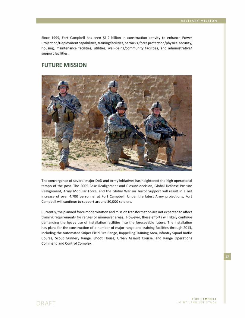
Since� 1999,� Fort� Campbell� has� seen� $1.2� billion� in� construction� activity� to� enhance� Power�Projection/Deployment�capabilities,�training�facilities,�barracks,�force�protection/physical�security,�housing,� maintenance� facilities,� utilities,� well-being/community� facilities,� and� administrative/support�facilities.
FUtUre mission
The�convergence�of�several�major�DoD�and�Army�initiatives�has�heightened�the�high�operational�tempo�of� the�post.� The�2005�Base�Realignment�and�Closure�decision,�Global�Defense�Posture�Realignment,� Army�Modular� Force,� and� the�Global�War� on� Terror� Support�will� result� in� a� net�increase� of� over� 4,700� personnel� at� Fort� Campbell.� Under� the� latest� Army� projections,� Fort�Campbell�will�continue�to�support�around�30,000�soldiers.
Currently,�the�planned�force�modernization�and�mission�transformation�are�not�expected�to�affect�training�requirements�for�ranges�or�maneuver�areas.��However,�these�efforts�will�likely�continue�demanding� the�heavy�use�of� installation� facilities� into� the� foreseeable� future.� The� installation�has�plans�for�the�construction�of�a�number�of�major�range�and�training�facilities�through�2013,�including�the�Automated�Sniper�Field�Fire�Range,�Rappelling�Training�Area,�Infantry�Squad�Battle�Course,� Scout� Gunnery� Range,� Shoot� House,� Urban� Assault� Course,� and� Range� Operations�Command�and�Control�Complex.

Fo R T c A m pb e l l J o i n t L a n d U s e s t U d y
28
dRaFt
m i l i T A R y m i s s i o n
militAry economic imPActFort�Campbell�is�a�significant�economic�engine�for�the�region�and�the�largest�single�employer�in�Kentucky�and�Tennessee.��According�to�statistics�for�FY�2007,�the�installation�circulated�more�than�$2.7�billion�throughout�the�area,�including�direct�payroll,�construction,�and�contracts�(See�Table�7).��The�Army�also�estimates�that�over�14,000�soldiers�and�40,000�family�members�live�off-post�in�the�Clarksville,�TN-KY�Metropolitan�Statistical�Area.
Aside� from� the� direct� expenditures� associated� with� salaries� and� contracts,� military� activity�produces�significant�indirect�economic�impacts.�Active�duty�and�civilian�employees,�retirees,�and�dependents�spend�their�paychecks�on�local�goods�and�services,�generating�jobs�in�retail�and�other�supporting�sectors.�Employers�then�hire�more�workers,�who�in�turn�make�local�purchases,�further�cycling� dollars� through� the� economic� region.� � According� to� a� fiscal� analysis� conducted� by� the�Kentucky�Commission�on�Military�Affairs,�a�gain�of�1,000�soldiers�at�Fort�Campbell�will�result�in�1,033�new�jobs�and�a�payroll�increase�of�$30�million�in�the�State�of�Kentucky�alone.�The�overall�estimated�employment�multiplier�associated�with�the�number�of�military�personnel�assigned�to�a�military�installation�typically�ranges�from�1.08�to�1.80.��This�means�that�for�each�100�military�personnel�assigned�to�the�post,�the�private�sector�will�create�between�108�and�180�permanent�new�jobs.
Combat�pay�further�accelerates�the�multiplier�effect�within�the�regional�economy�by�generating�more�disposable�income�for�military�families.��As�a�result�of�deployment,�members�of�the�101st�Airborne�Division�received�increased�take-home�income�of�approximately�$150-200M�due�to�tax-free�income/combat�pay�during�deployment.�Soldiers�also�received�$64.5M�in�retention�bonuses�in�FY06�and�$18M�in�FY07.�
The�Clarksville-Montgomery�County�Economic�Development�Council�completed�a�Labor�Market�Assessment�for�the�Fort�Campbell� region� in�May�of�2007.� �The�study� identified�the�skilled�and�talented� potential� workforce� of� Army� retirees� and� spouses� as� one� of� the� region’s� strongest�economic�assets.�Retention�statistics�reinforce�the�positive�relationship�between�quality�of�life�on�the�installation�and�in�the�surrounding�communities.�The�101st�Airborne�Division/Fort�Campbell�had�the�highest�re-enlistment�rate�in�FY06�with�over�60�percent�of�re-enlisting�soldiers�choosing�to�remain�at�Fort�Campbell.
Total Economic Impacts in the Region, FY 2007
tA
Bl
e 7
Major�Construction $179�Million
Appropriated�Funds�Contracts $60�Million
Payroll $2.43�Billion
Additional�Sources $25�Million
Total�Economic�Disbursement $2.7�Billion

3.0 Regional demographics and Growth trends

Fo R T c A m pb e l l J o i n t L a n d U s e s t U d y
Fo R T c A m pb e l l J o i n t L a n d U s e s t U d y
31
dRaFt
R e g i o n A l D e m o g R A p H i c s A n D g R o w T H T R e n D s
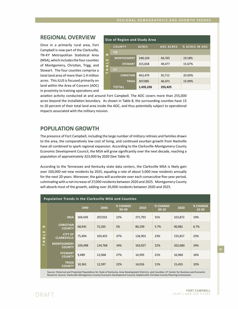
regionAl overview Once� in� a� primarily� rural� area,� Fort�Campbell�is�now�part�of�the�Clarksville,�TN-KY� Metropolitan� Statistical� Area�(MSA),�which�includes�the�four�counties�of� Montgomery,� Christian,� Trigg,� and�Stewart.��The�four�counties�comprise�a�total�land�area�of�more�than�1.4�million�acres.��This�JLUS�is�focused�primarily�on�land�within�the�Area�of�Concern�(AOC)�in�proximity�to�training�operations�and�aviation�activity�conducted�at�and�around�Fort�Campbell.�The�AOC�covers�more� than�255,000�acres�beyond�the�installation�boundary.��As�shown�in�Table�8,�the�surrounding�counties�have�15�to�20�percent�of�their�total�land�area�inside�the�AOC,�and�thus�potentially�subject�to�operational�impacts�associated�with�the�military�mission.�
PoPUlAtion growth The�presence�of�Fort�Campbell,�including�the�large�number�of�military�retirees�and�families�drawn�to�the�area,�the�comparatively�low�cost�of�living,�and�continued�exurban�growth�from�Nashville�have�all�combined�to�spark�regional�expansion.�According�to�the�Clarksville-Montgomery�County�Economic�Development�Council,�the�MSA�will�grow�significantly�over�the�next�decade,�reaching�a�population�of�approximately�323,000�by�2020�(See�Table�9).
According�to� the�Tennessee�and�Kentucky�state�data�centers,� the�Clarksville�MSA� is� likely�gain�over�100,000�net�new�residents�by�2025,�equaling�a�rate�of�about�5,000�new�residents�annually�for�the�next�20�years.�Moreover,�the�gains�will�accelerate�over�each�consecutive�five-year�period,�culminating�with�a�net�increase�of�27,000�residents�between�2020�and�2025.��Montgomery�County�will�absorb�most�of�the�growth,�adding�over�20,000�residents�between�2020�and�2025.�
Size of Region and Study Area
tA
Bl
e 8
co U n t y Ac r e s Ao c Ac r e s % Ac r e s i n Ao c
t n
montgomery 348,104 66,765 19.18%
stewArt 315,658 49,477 15.67%
k y
christiAn 463,479 92,712 20.00%
trigg 307,985 46,471 15.09%
totAl 1,435,226 255,425
Population Trends in the Clarksville MSA and Counties
tA
Bl
e 9
1990 2000 % chAnge 90-00 2010 % chAnge
00-10 2020 % chAnge 10-20
msA 169,439 207,033 22% 271,793 31% 323,872 19%
christiAn coUnty 68,941 72,265 5% 80,199 5.7% 90,981 6.7%
city oF clArksville 75,494 103,455 37% 126,901 23% 155,817 23%
montgomery coUnty 100,498 134,768 34% 163,927 22% 202,680 24%
stewArt coUnty 9,489 12,068 27% 14,595 21% 16,960 16%
trigg coUnty 10,361 12,597 22% 14,016 11% 15,455 10%
Source:�Historical�and�Projected�Populations�for�State�of�Kentucky,�Area�Development�Districts,�and�Counties;�UT�Center�for�Business�and�Economic�Research;�Source:�Clarksville-Montgomery�County�Economic�Development�Council;�Hopkinsville-Christian�County�Planning�Commission
Fo R T c A m pb e l l J o i n t L a n d U s e s t U d y
32
dRaFt
R e g i o n A l D e m o g R A p H i c s A n D g R o w T H T R e n D s
The� Kentucky� State� Data� Center� and�Hopkinsville-Christian�County�Planning�Commission� also� project� steady�localized�growth�in�areas�north�of�Fort�Campbell.� While� still� primarily� rural�in� character,� both� Trigg� and� Stewart�Counties�also�show�steady�growth�rates�that could result in the increased risk of�land�use�conflict�along�the�western�edge�of�the�installation.��
Figure� 5� shows� population� density�around� Fort� Campbell� as� of� 2005.�The� highest� regional� densities� are�along� Highway� 41� adjacent� to� the�
cantonment� area� and� in� the� urban� cores� of� Clarksville� and� Hopkinsville.� Other� significant�pockets�of�housing�posing�a�higher�risk�of�encroachment�are�along�the�far�eastern�portion�of�Highway�79�near�SAH�and�in�the�City�of�Oak�Grove�in�proximity�to�CAAF�operations.�
coUnty ProFilesMONTGOMERY COUNTY, TNMontgomery�County,�which�lies�40�miles�northwest�of�Nashville,�is�543�square�miles.�The�county�seat�and�regional�urban�center�of�Clarksville� is�Tennessee’s�fifth�largest,�and�one�of�the�state’s�fastest�growing�cities.��Montgomery�County�has�grown�beyond�its�original�agricultural�roots�to�become�a�major�transport,�industrial,�retail,�and�professional�center�in�the�state.�The�county�is�home�to�many�Fort�Campbell�personnel,�the�students�and�faculty�of�Austin�Peay�State�University,�and� a� vibrant� cultural� and� outdoor� recreational� scene� focused� around� historic� downtown�Clarksville�and�the�Cumberland�River.��Montgomery-Clarksville�lies�to�the�east�and�south�of�Fort�Campbell�with�approximately�19�percent�of�its�land�area�falling�within�the�JLUS�Area�of�Concern.
STEWART COUNTY, TNStewart� County,� set� along� the� Cumberland� River,� is� celebrated� for� its� cultural� and� outdoor�recreation� amenities,� including� the� Fort� Donelson� National� Battlefield� and� Cemetery,� Cross�Creeks�National�Wildlife�Refuge,�Lake�Barkley,�Kentucky�Lake,�Land�between�the�Lakes�National�Recreation�Area,�Dover�City�Lick�Creek�Park,�Dyer’s�Creek�Park�and�Paris�Landing�State�Park.��This�mostly�rural�county�has�a�total�land�area�of�493�square�miles�and�contains�a�significant�proportion�of�federally�owned�land.��Its�two�municipalities�are�the�county�seat�of�Dover�and�Cumberland�City.��Stewart�County�sits�to�the�southwest�of�the�post.�The�JLUS�Area�of�Concern�encompasses�about�15�percent�of�county�land.�
CHRISTIAN COUNTY, KYChristian�County,�Kentucky,�which�lies�north�of�the�Kentucky/Tennessee�border�is�one�of�the�nine�counties�in�the�Pennyrile�Area�Region�in�Western�Kentucky.�Its�county�seat�and�major�municipality�is�the�City�of�Hopkinsville,�a�retail�hub�for�the�southwestern�part�of�the�state,�and�the�setting�for�culture� and� historic� architecture.�Other�municipalities� include:�Oak�Grove,� Crofton,� LaFayette,�

Fo R T c A m pb e l l J o i n t L a n d U s e s t U d y
33
dRaFt
R e g i o n A l D e m o g R A p H i c s A n D g R o w T H T R e n D s
Figure� 5.� Population� Density� -� 2005� (11� by� 17�z-folded�map)

Fo R T c A m pb e l l J o i n t L a n d U s e s t U d y
34
dRaFt
R e g i o n A l D e m o g R A p H i c s A n D g R o w T H T R e n D s
Figure�5.�Population�Density� -�2005�(11�by�17�z-folded�map)
Fo R T c A m pb e l l J o i n t L a n d U s e s t U d y
35
dRaFt
R e g i o n A l D e m o g R A p H i c s A n D g R o w T H T R e n D s
Figure� 6.� Recent� Development� Activity,� Sabre�Heliport�(11�by�17�z-folded�map)

Fo R T c A m pb e l l J o i n t L a n d U s e s t U d y
36
dRaFt
R e g i o n A l D e m o g R A p H i c s A n D g R o w T H T R e n D s
Figure� 6.� Recent� Development� Activity,� Sabre�Heliport�(11�by�17�z-folded�map)
Fo R T c A m pb e l l J o i n t L a n d U s e s t U d y
37
dRaFt
R e g i o n A l D e m o g R A p H i c s A n D g R o w T H T R e n D s
and�Pembroke.�Christian�County�has�a�healthy�base�of�jobs�in�the�manufacturing,�agriculture,�and�distribution�sectors,�and�historic�ties�to�Fort�Campbell,�which�lies�to�its�south.�Given�its�proximity�to�the�installation,�the�City�of�Oak�Grove�in�particular�has�a�strong�military�presence�within�the�community.�The�county�is�geographically�diverse�with�a�total�land�area�of�724�square�miles,�20�percent�of�which�are�inside�the�Area�of�Concern.��
TRIGG COUNTY, KYTrigg�County,�KY,�whose�southern�border�is�the�State�of�Tennessee,�is�421�square�miles�in�area�and�contains�a�portion�of�the�Land�between�the�Lakes�recreation�area�and�the�Lake�Barkley�State�Resort�Park.�Its�county�seat�is�the�historic�community�of�Cadiz.��Along�with�neighboring�Christian�County�to�the�east,�Trigg�County� is�a�member�of�the�nine-county�Pennyrile�Area�Development�District.�The�county�lies�to�the�northwest�of�the�installation�and�has�about�15�percent�of�its�land�area�inside�the�Area�of�Concern.
recent develoPment ActivityThe�community�of�Clarksville�to�the�east�of�the�post�is�the�fastest�growing�of�the�region’s�population�centers.�The�city’s�residential�and�commercial�development�is�along�the�US�41A�corridor�across�from� the� post� cantonment� area� and� effectively� buffered� from� the� installation’s� airfields� and�ranges.��Southeast�Clarksville�(near�the�I-24�Exit�4)�also�has�strong�commercial�growth.�The�most�significant�trend�shaping�compatibility�issues�near�the�installation�is�the�demand�for�residential�housing�that� is� increasing�pressure�to�develop�the�remaining�farms�and�wooded�areas�on�the�urban�edge.�In�Clarksville-Montgomery�County,�the�Planned�Growth�Areas�near�Exits�1�and�4�off�of�I-24�are�approaching�capacity.�As�a�result,�developers�are�seeking�opportunities�for�residential�development� in� Planned�Growth� Area� #1� just� south� of� the� installation� and� adjacent� to� SAH.� See�Figure�6. The� communities� north� of� Fort� Campbell� are� also� expanding.� In� the� late� 1990s,� the� City� of�Hopkinsville�annexed�an�11-mile�corridor�along�U.S.�Highway�41A,�bringing�its�corporate�limits�to�within�one�mile�of�CAAF.�Annexation�has� already� spurred� construction�along� the� corridor,� including� a�Wal-Mart� Distribution� Center,�new� residential� subdivisions,� such�as� Windmill� Farms,� and� several�commercial�uses.�The�corridor�will�continue� to� draw� development�south� toward� Fort� Campbell.� Also�in� Hopkinsville,� a� developer� has�purchased� a� large� tract� of� land�around� Bell� Station� Road� just�north�CAAF.�Much�of�the�land�falls�under� an� existing� easement� and�lacks� wastewater� infrastructure;�however,� the� developer�may� seek�a� sewer� extension.� � One� of� the�

Fo R T c A m pb e l l J o i n t L a n d U s e s t U d y
38
dRaFt
R e g i o n A l D e m o g R A p H i c s A n D g R o w T H T R e n D s
largest�planned�developments� in�the�region� is� the�2,000-acre� Interstate�24� Industrial�Park� just�north�of�the�I-24/41A�interchange.�Currently�optioned�by�Hopkinsville�Industrial�Foundation,�the�site�sits�between�Exits�86�and�89�along�the�I-24�corridor.�Developers�are�seeking�a�single�industrial�tenant,�such�as�an�automobile�plant,�for�the�site.�The�land�currently�lacks�access�to�water,�sewer,�or�gas�infrastructure�along�its�southern�boundary�and�would�have�to�connect�to�existing�utility�systems�along�41A.
The� lack� of�wastewater� treatment�has�historically�acted�as�the�major�drag�on�growth� in� the�City�of�Oak�Grove.� Facilities� currently� operate�at� 64� percent� of� available� sewer�capacity.� Despite� infrastructure�challenges,� the� city� has� issued�permits� for� 1,300� new� houses.� A�development� by� the� Oak� Grove�Tourism� Commission� on� Walter�Garrett�Lane�off�of�41A�just�east�of�CAAF� will� feature� a� walking� trail,�playground,�city�amphitheater,�and�convention� center.� � Staff� at� Oak�Grove�also�noted�new�development�
along�KY�Hwy�911�(Thompsonville�Lane),�including�residential�with�pockets�of�commercial�and�big�box�retail.
The�relatively�recent�expansion�of�US�41�to�six-lanes�has�also�facilitated�commercial�activity�along�the�corridor,�increasing�pressure�to�convert�the�unincorporated�farmland�west�of�US�41�into�more�intense�residential�and�retail�uses.�See�Figure�7.
Growth� to� the�west� Fort� Campbell� in� Stewart� County,� Tennessee� and� Trigg� County,� Kentucky�has� been� slow� relative� to� other� parts� of� the� region.� The� area’s� appealing� rural� character� and�inexpensive�land�costs�have,�however,�continue�to�attract�scattered�development�and�new�strip�residential�housing�focused�along�county�roads.
regionAl inFrAstrUctUre IInfrastructure,�particularly�roads�and�wastewater�treatment,�strongly�influence�private�property�investment�decisions�and�thus�overall�land�use�patterns�within�a�region.�System�extensions�enable�development� in�previously�rural�areas�and� increased�capacities�can�accommodate�bigger�scale�uses.� The� tendency�of� growth� to� spread� to� rural/agricultural� areas� at� higher� intensities� is� the�primary�factor�driving�land�use�conflicts�around�military�installations.
The� current� regional� transportation� network� consists� of� I-24,� a� major� northwest-southeast�interstate�route�through�southern�Illinois,�Kentucky,�and�Tennessee�linking�Nashville�to�Clarksville;�US� 41A,� which� runs� north-south� along� the� eastern� border� of� the� post� and� provides� primary�access�to�Fort�Campbell’s�gates;�and�US�79,�which�runs�east-west�parallel�to�the�post’s�southern�

Fo R T c A m pb e l l J o i n t L a n d U s e s t U d y
39
dRaFt
R e g i o n A l D e m o g R A p H i c s A n D g R o w T H T R e n D s
Figure� 7.� Recent�Development� Activity,� CAAF� (11�by�17�z-folded�map)

Fo R T c A m pb e l l J o i n t L a n d U s e s t U d y
40
dRaFt
R e g i o n A l D e m o g R A p H i c s A n D g R o w T H T R e n D s
Figure� 7.� Recent�Development� Activity,� CAAF� (11�by�17�z-folded�map)

Fo R T c A m pb e l l J o i n t L a n d U s e s t U d y
41
dRaFt
R e g i o n A l D e m o g R A p H i c s A n D g R o w T H T R e n D s
boundary,�connecting�Clarksville�to�Dover.�Interstate�24�has�eight�interchanges�between�Exit�11�in�Tennessee�and�Exit�65�in�Kentucky,�forming�some�of�the�major�commercial�development�nodes�in� the�Clarksville-Hopkinsville�metropolitan� area.�US�41A� is� a� burgeoning� commercial� corridor�that� connects� Clarksville,� Oak� Grove� and� Hopkinsville.� Other� significant� roads� in� the� regional�transportation�system�include�the�north-south�Pennyrile�Parkway,�running�north-south�between�the�Kentucky�cities�of�Hopkinsville,�Madisonville,�and�Henderson;�US�41,�which�connects�Nashville�to�Hopkinsville�east�of�I-24;�and�US�68,� linking�the�cities�of�Cadiz�and�Hopkinsville�north�of�the�installation.
In�the�Fort�Campbell�region,�several�major�transportation�projects�will�support�additional�growth,�particularly�in�areas�to�the�northeast�and�south�of�the�installation�(See�Figure�8).�The�extension�of�the�state�arterial�highway,�Pennyrile�Parkway,�from�Hopkinsville�to�I-24�will�extend�the�availability�of�utilities,�thus�potentially�anchoring�more�intensive�land�uses�in�an�area�about�2�½�miles�north�of�CAAF.�This�area�is�also�likely�to�emerge�as�a�major�commercial�hub�given�interchange�access�to�the�interstate.�Phase�I�of�the�two-to-three�year�project,�the�Eagle�Way�bypass,�is�currently�underway.��The�likely�effect�of�these�combined�projects�is�to�draw�more�growth�southward�from�the�City�of�Hopkinsville�toward�aviation�related�impacts�associated�with�CAAF.
Also�to�the�east�of�the�post�in�the�City�of�Oak�Grove,�the�Kentucky�Department�of�Transportation�is�currently�designing�a�project�to�widen�KY�911�to�five�lanes.�Along�with�transportation�improvements,�Oak� Grove� has� connected� to� the�wastewater� infrastructure� of� the� City� of� Hopkinsville.� Since�constraints�on�wastewater�availability�have�previously� limited�growth� in�Oak�Grove,� increased�treatment� capacity� will� very� likely� spur� further� development.� Utility� providers� have� planned�various�other�improvements�focused�particularly�around�Hopkinsville�and�Oak�Grove,�reflecting�significant�development�pressure�in�these�areas�north�and�east�of�CAAF.
One�of�the�region’s�most�significant�current�transportation�initiatives�is�the�widening�of�Highway�79,�an�east-west�arterial�that�parallels�the�southern�boundary�of�the�installation.�Previously�a�rural�two�

Fo R T c A m pb e l l J o i n t L a n d U s e s t U d y
42
dRaFt
R e g i o n A l D e m o g R A p H i c s A n D g R o w T H T R e n D s
lane�highway,�the�expanded�four�lane�corridor�will�now�be�able�to�attract�additional�commercial�and�residential�development�in�proximity�to�SAH�and�several�adjacent�training�areas.
While�much�of�the�infrastructure�analysis�focuses�on�the�tendency�of�increased�capacity�to�induce�potentially�incompatible�growth�around�Fort�Campbell,�the�post�and�surrounding�communities�also�have�opportunities�to�enhance�performance�and�achieve�efficiency�through�the�joint�delivery�of�regional�services.�One�of�the�best�examples�is�the�Bi-County�Landfill�on�Highway�79.��The�facility�provides�Montgomery�County,�Stewart�County,�and�Fort�Campbell�with�over�100�years�of�solid�waste�disposal�capacity.

Fo R T c A m pb e l l J o i n t L a n d U s e s t U d y
43
dRaFt
R e g i o n A l D e m o g R A p H i c s A n D g R o w T H T R e n D s
Figure�8.�Regional�Infrastructure�Projects�(11�by�17�z-folded�map)
Fo R T c A m pb e l l J o i n t L a n d U s e s t U d y
44
dRaFt
R e g i o n A l D e m o g R A p H i c s A n D g R o w T H T R e n D s
Figure�8.�Regional�Infrastructure�Projects�(11�by�17�z-folded�map)

4.0 operational impacts and Hazards

Fo R T c A m pb e l l J o i n t L a n d U s e s t U d y

Fo R T c A m pb e l l J o i n t L a n d U s e s t U d y
47
dRaFt
o p e R A T i o n A l i m p A c T s A n D H A z A R D s
overviewAs�with�all�active�military�installations,�routine�training�and�readiness�activities�at�Fort�Campbell�produce�various�impacts�that�can�affect�the�quality�of�life�in�surrounding�communities.�Conversely,�these�military�operations�are�susceptible�to�physical�hazards�created�by�certain�proximate�civilian�activities�or�to�complaint�due�to�the�sensitivity�of�affected�nearby�uses.�
The�planning�team�consulted�with�the�Technical�Coordinating�Committee�(TCC)�and�interviewed�regional� stakeholders� to� identify� key� impacts� from� a� broader� list� of� potential� compatibility�issues,�including:�
exposure�of�residents�to�noise�associated�with�aviation�operations •exposure�of�residents�to�noise�associated�with�large�arms�training •vibration�and�dust�from�training�activities •smoke�from�prescribed�burns�on�the�installation� •exposure�of�residents�and�businesses�to�the�risk�of�an�aircraft�accident •vertical�structures�that�protrude�into�the�controlled�airspace�around�the�post� •competition�for�use�of�the�electromagnetic�spectrum •outdoor�lighting�systems,�especially�streetlights�or�exterior�security�lighting�associated�with� •large�buildings�that�allow�significant�light�to�travel�upward�into�an�otherwise�darkened�sky;�the� resulting� “light�pollution”� can�obscure�pilot� vision�or� interfere�with� the�use�of�night�vision�training�devices
activities�that�tend�to�attract�large�bird�populations,�such�as�landfills�or�open�water •activities�that�release�substances�into�the�air,�such�as�steam,�dust,�or�smoke�that�can�impair� •aviator� vision;�examples�of� these�activities�are� industrial�plants,� refineries,�quarries,� and�sand�or�gravel�pits
the� loss�of� threatened�and�endangered� species,� agricultural� lands,� and� �environmentally� •sensitive�resources�
civilian�radio�frequency�devices,�such�as�those�used�by�industry�or�public�safety�agencies� •that� overlap� with�military� radio� frequencies,� affecting� on-board� electronic� systems� and�communications�equipment
transportation�impacts�on�area�roadways� •
Based�upon�feedback�from�the�TCC�and�a�review�of�existing�conditions�and�key�documents,�such�as� the� Army’s� Installation� Environmental� Noise� Management� Plan� (IENMP),� the� planning� team�identified�the�following�issues�as�the�primary�threats�to�mission�viability�and�regional�quality�of�life:
exposure�of�residents�to�noise�associated�with�aviation�operations •
exposure�of�residents�and�businesses�to�the�risk�of�an�aircraft�accident •
visual�interference�with�the�night�vision�training�environment�associated�with�exterior�lighting� •
These�critical�issues,�which�are�described�in�more�detail�below,�create�a�series�of�overlapping�spatial�patterns�around�the�installation.�As�shown�in�Figure�9,�noise�exposure�of�60�dB�or�higher�(sufficient�to�intrude�on�daily�activities)�affects�approximately�20,000�acres�off�post�and�over�400�acres�of�land�fall�under�an�Accident�Potential�Zone�associated�with�CAAF.
These�areas�of�off-post�impact�form�the�basis�for�the�Fort�Campbell�Activity�Zones�identified�in�the�recommendations�section�of�this�report.��

Fo R T c A m pb e l l J o i n t L a n d U s e s t U d y
48
dRaFt
o p e R A T i o n A l i m p A c T s A n D H A z A R D s
The�JLUS�also�includes�a�series�of�strategies�to�address�additional�issues�that�can�affect�the�viability�of� the�mission�and� regional�well-being,� such�as� the� loss�of� threatened�and�endangered� species,�agricultural�lands,�and�environmentally�sensitive�resources�due�to�unmanaged�development.
noiseNoise-generating� training� at� Fort� Campbell� includes� ground-based� activities� such� as� live-fire�weapons�training�and�unit�convoy�maneuvers,�along�with�aviation�activities,�including�air�assault�exercises� and� nap-of-the-earth� flight� procedures.� For� purposes� of� assessing� noise� impacts� on�the�surrounding�communities,�the�Installation�Environmental�Noise�Management�Plan�(IENMP)�designates� three� zones� reflecting� annualized� average� decibel� levels� or� day-night� sound� levels�(DNL).�It�should�be�emphasized�that�these�zones,�which�are�graphically�shown�as�contours�on�maps,�are�not�discrete�lines�that�sharply�divide�loud�areas�from�land�largely�unaffected�by�noise.�Instead�these�zones�are�planning�tools�that�depict�the�general�noise�environment�around�the�post�based�on�typical�activities.�Areas�beyond�the�three�zones�can�also�experience�levels�of�noise�deemed�unacceptable�depending�upon�such�variables�as�training�intensity�or�weather�conditions.
The�military�measures�noise�in�decibels�(dB)�and�assigns�a�weighting�based�on�the�noise�frequency�and� source.� � A-weighting,� expressed� as� dBA,� depicts� higher� frequency� noise� caused� by� small�arms�firing,�aircraft�use,�and�vehicle�operations.��C-weighting�shows�the�low�frequency�noise�and�vibration�associated�with�the�firing�of�larger�weapons�systems�(dBC).�Noise�in�excess�of�55�dB�can�become�intrusive�and�continued�exposure�to�noise�above�the�85�dBA�threshold�can,�over�time,�cause�hearing�loss.��
The� contours� around� Fort� Campbell� reflect� an� annualized� noise�measure� that� converts� noise�varying�from�peak�bursts�to�relative�quiet�into�a�steady�measure�of�acoustic�energy�over�a�24�hour�period.�The�contours�essentially�take�all�operations�that�occur�at�the�military�installation�over�the�
year�and�divide�by�365�days,�producing�the�average�day-night�sound�level�(DNL).��The�measure�further�“penalizes”�or�places�a�higher�decibel� value�on�noise� that�occurs� at� night�because�it� is�more�disruptive� to� the� surrounding�population.� Table�11�equates�decibel�levels�with�common�sounds.
It�should�be�noted�that�the�noise�modeling�around�CAAF�and�SAH�also�depict�the�Land�Use�Planning�Zone�(LUPZ)�contours,�giving� flexibility� to� the�U.S.� Army� to� accommodate� increases�in�operational�activity�and�maintaining�the�noise�footprints�on�which�local�land�use�regulations�are�based�for�the�foreseeable�future.� The� LUPZ� contour� limits� for� aviation� and� blast� noise�activities�are�5�dB�below�Zone�II� levels�and�can�better�predict�noise� impacts�when� levels� of� operations� at� airfields� or� large�caliber�weapons�ranges�are�above�average.
Installations��can�also�use�peak�noise�data�mapping�to�supplement�the�current�method�of�day-night�average�noise�modeling.� �Peak�noise�mapping�contributes�to�an�improved�understanding�of�the�noise�environment�around�the�post�because�it�models�the�noise�effects� for� the� single� burst� of� sound� associated�with� a� training�
Land in Noise & Air Safety Affected Areas
tA
Bl
e 1
0
noise contoUrs (60dB+)
Acres (outside FTC)
cAAF
��60-65dB 6,086
��65-70dB 4,099
��70-75dB 7,417
75dB 2,137
SubTotal 19,739
sAh
��65-70dB 302
��70-75dB 233
SubTotal 535
totAl 20,274
Accident Potential Zones
CAAF 433
totAl 433
Fo R T c A m pb e l l J o i n t L a n d U s e s t U d y
49
dRaFt
o p e R A T i o n A l i m p A c T s A n D H A z A R D s
Figure�9.�Noise�Contours�for�CAAF�and�Sabre�Army�Heliport�(11�by�17�z-folded�map)

Fo R T c A m pb e l l J o i n t L a n d U s e s t U d y
50
dRaFt
o p e R A T i o n A l i m p A c T s A n D H A z A R D s
Figure�9.�Noise�Contours�for�CAAF�and�Sabre�Army�Heliport�(11�by�17�z-folded�map)

Fo R T c A m pb e l l J o i n t L a n d U s e s t U d y
51
dRaFt
o p e R A T i o n A l i m p A c T s A n D H A z A R D s
event�and�reflects�what�people�exposed�to� the� noise� actually� hear,� rather� than�a� weighted� average.� Additionally,� peak�levels�correlate�well�with�complaint�risk�for�individual�firing�activities
NOISE ZONE III. �NZ� III� consists�of� the�area� around� the� noise-generating�activity� in� which� the� DNL� exceeds� 75�decibels�for�aircraft,�vehicles,�and�small�arms� (A-weighted),� and� more� than�70� decibels,� C-weighted� for� weapon�systems�larger�than�20-mm.��The�noise�level�within�NZ� III� is� severe� enough� to�conflict� with� many� civilian� activities,�particularly�sensitive�land�uses,�such�as�housing,�schools,�medical�facilities,�and�places�of�worship.
NOISE ZONE II. �NZ�II�consists�of�an�area�where�the�A-weighted�DNL�is�between�65�and�75�decibels�and�the�C-weighted�DNL� is� between� 62� and� 70� decibels.��Guidance� deems� noise� exposure�within� this� area� to� be� significant� and�recommends� limiting� use� of� land� to�non-sensitive�activities�such�as�industry,�manufacturing,� transportation,� and�agriculture.��However,�if�the�community�determines� that� land� in� NZ� II� areas�must�be�used�for�residential�purposes,�guidance� suggests� that� the� design�and� construction� of� the� buildings�incorporate�noise�level�reduction�(NLR)�features� to� minimize� the� annoyance�experienced�by�residents.
LAND USE PLANNING ZONE. The�Land�Use�Planning�Zone�consists�of�an�area�where�the�day-night�sound�level�(DNL)�is�between�60�and�65�dBA�or�57�and�62�dBC.�Exposure�to�noise�within�this�area�is�considered�significant�during�periods�of�increased�operations.�The�LUPZ�accounts�for�the�variability�of�noise�levels�caused�by�higher�daily�numbers�of�operations�than�the�annual�average.�It�shows�where�levels�of�annoyance�usually�associated�with�Noise�Zone�II�can�be�found�during�periods�of�increased�operations.�The�LUPZ�provides�the�installation�with�a�means�to�predict�possible�complaints,�and�meet�the�public�demand�for�a�description�of�what�will�exist�during�a�period�of�increased�operations.
It�should�be�noted�that�the�other�military�services,�through�comparable�AICUZ�land�use�compatibility�guidelines,�already�recommend�that�residential�uses�be�considered�as�incompatible�uses�within�
Comparable Noise Levels
soUnd dBA eFFect
tA
Bl
e 1
1
Jet�Engines�(Near) 140
Shotgun�Firing 130
Jet�Takeoff�(100-200�Fort) 130 Threshold�of�pain�(125�dBA)
Thunderclap�(Near) 120 Threshold�of�sensation�(120�dBA)
Power�Saw�(Chain�Saw) 110
Jet�Fly-over�(1000�Fort) 103
Garbage�Truck/Cement�Mixer 100
Regular�exposure�for�1 minute or more risks permanent�hearing�loss
Farm�Tractor 98
Lawnmower,�Food�Blender 85-90 Level�at�which�hearing�loss�
begins�(8�hour�exposure)
Recreational�Vehicles,�TV 70-90
Diesel�Truck�(40�Mph,� 50�Fort) 84
Garbage�Disposal 80Annoyance;�constant�exposure�may�cause�hearing�loss
Washing�Machine 78
Dishwasher 75
Vacuum�Cleaner 70 Intrusive,�interference�with�conversation
Hair�Dryer 70
Normal�Conversation 60-65 Comfortable�(under�60�dBA)
Refrigerator�Humming 40
Whisper 30 Very�quiet
Rustling�Leaves 20 Just audible
Normal�Breathing 10
0 Threshold�of�normal�hearing�(1000-4000�Hz)

Fo R T c A m pb e l l J o i n t L a n d U s e s t U d y
52
dRaFt
o p e R A T i o n A l i m p A c T s A n D H A z A R D s
the� 65db-75db� noise� contour.� This� guidance� further� states� that� “Although� local� conditions�regarding� the� need� for� housing�may� require� residential� use� in� these� zones,� residential� use� is�discouraged.�The�absence�of�viable�alternative�development�options�should�be�determined�and�an�evaluation�should�be�conducted�locally�prior�to�local�approvals�indicating�that�a�demonstrated�community�need�for�the�residential�use�would�not�be�met�if�development�were�prohibited�within�these�Zones.”
AviAtionThe�high�number�of�annual�aircraft�operations�at�CAAF�generates�noise�levels�beyond�the�installation�that�can�interfere�with�the�daily�activities�of�nearby�residents.�Noise�contours�from�75+�to�65�dBA�extend�north�from�the�airfield�affecting�portions�of�Oak�Grove,�Hopkinsville,�and�unincorporated�Christian�County�(See�Figure�9).��With�the�equivalent�of�NZ�II�exposure,�these�areas�will�experience�aviation-related�noise�that�poses�conflicts�for�sensitive�uses,�such�as�housing,�schools,�offices�or�places�of�assembly.��Similarly,�activity�at�SAH�produces�NZ�II�equivalent�noise�exposure�for�areas�just�to�the�east�and�south�of�the�heliport.�The�risk�of�noise�related�incompatibilities,�however,�is�less�for�the�post’s�southern�airfield�due�to�the�comparatively�small�area�affected�by�operations.
Fort�Campbell�also�has�two�major�low-level�helicopter�training�routes,�the�Red�and�Blue�Routes�that�mostly�parallel� the� installation�boundary.� � Relatively�high�use�and� the� low�flight� levels� at�which�operations�are�conducted�contribute�to�significant�noise�exposure�for�areas�adjacent�to�the�post.�(See�Figure�10) smAll And lArge ArmsLive�training�exercises�at�Fort�Campbell� include�the�direct�and�indirect�firing�of�both�small�and�large�arms�systems,�including:
small�arms�(.30�cal�and�below)�at�the�Small�Arms�Impact�Area�west�of�the�cantonment�area� •and�south�of�CAAF
artillery�and�mortar�at�the�North�and�South�Impact�Areas •
tank�gunnery�at�Ranges�28�(South�Impact�Area)�and�46�(North�Impact�Area);�training�consists� •of�tactical�movements�in�combination�with�weapons�fire�to�simulate�battlefield
aerial�gunnery,�including�7.62�mm�door�gun,�20�mm�gun,�30�mm�gun,�inert�TOW�missile�and� •HELLFIRE�missile
Grenade/Claymore�Mines� at� Range� 24,� Ranges� 26A� and� 26B� (inert� and� high� explosive),� •Ranges�25A�and�47,�and�Range�1
As�noted�earlier,�most�of�the�noise�issues�at�Fort�Campbell�are�aviation,�rather�then�arms�related.�Small�arms�range�activities�produce�noise�contours�that�extend�beyond�the�installation�boundary,�but�do�not�pose�significant�compatibility�issues�with�surrounding�uses.��The�firing�of�large�caliber�weapons�(20mm�and�greater)�can,�however,�affect�areas�off-post,�particularly�portions�of�Christian�County�and�communities�such�as�Lafayette�to�the�north.�(See�Figure�11)
Air sAFetyIn�addition�to�noise,�the�IENMP�assesses�the�potential�hazards�associated�with�aviation�activity.�Military�airfield�planning�analyzes�historical�data�on�military�aircraft�accidents�to�determine�where�a�mishap�is�most�likely�to�take�place�and�the�size�of�the�area�likely�to�be�affected.�The�analysis�does�

Fo R T c A m pb e l l J o i n t L a n d U s e s t U d y
53
dRaFt
o p e R A T i o n A l i m p A c T s A n D H A z A R D s
Figure�11.�Large�Caliber�Weapons�Noise�Contours�(11�by�17�z-folded�map)

Fo R T c A m pb e l l J o i n t L a n d U s e s t U d y
54
dRaFt
o p e R A T i o n A l i m p A c T s A n D H A z A R D s
Figure�11.�Large�Caliber�Weapons�Noise�Contours�(11�by�17�z-folded�map)

Fo R T c A m pb e l l J o i n t L a n d U s e s t U d y
55
dRaFt
o p e R A T i o n A l i m p A c T s A n D H A z A R D s
Figure�12.�Accident�Potential�Zones�for�CAAF�and�Sabre�Army�Heliport�(11�by�17�z-folded�map)

Fo R T c A m pb e l l J o i n t L a n d U s e s t U d y
56
dRaFt
o p e R A T i o n A l i m p A c T s A n D H A z A R D s
Figure�12.�Accident�Potential�Zones�for�CAAF�and�Sabre�Army�Heliport�(11�by�17�z-folded�map)

Fo R T c A m pb e l l J o i n t L a n d U s e s t U d y
57
dRaFt
o p e R A T i o n A l i m p A c T s A n D H A z A R D s
not�assess�the�statistical�probability�of�an�accident,�which�is�a�very�low�risk,�but�high�consequence�occurrence�for�both�pilot�and�nearby�civilians.�The�findings�of�the�analysis�result�in�three�air�safety�zones�around�the�airfield.
CLEAR ZONE (CZ). �The�CZ�is�an�area�3,000�feet�wide�by�3,000�feet� long�at�the�immediate�end�of�a�Class�B�runway.�The�CZ�for�a�Class�A�runway�is�an�area�1,000�feet�wide�by�3,000�feet�long.�CAAF�has�both�Class�A�and�Class�B�designated�runways.��The�accident�potential�in�these�areas�is�sufficient�to�warrant�the�prohibition�of�any�structures�in�the�CZs.�For�safety�reasons,�the�Army�has�the�authority�to�purchase�the�land�(or�development�rights)�for�these�areas�if�they�are�not�already�part�of�the�installation.
ACCIDENT POTENTIAL ZONE I (APZ I).��APZ�I�is�less�critical�than�the�Clear�Zone�but�still�possesses�significant�potential�for�accidents.��The�APZ�I�is�just�beyond�the�CZ,�forming�an�area�that�is�1,000�feet�wide�by�2,500�feet�long�for�a�Class�A�runway�and�1,000�feet�wide�by�5,000�feet�long�for�a�Class�B�runway.�A�wide�variety�of�industrial,�manufacturing,�transportation,�open�space�and�agricultural�uses�can�exist�safely�in�this�zone,�though�activities�that�concentrate�people�are�not�compatible.
ACCIDENT POTENTIAL ZONE II (APZ II). APZ�II�is�the�least�critical�of�the�three�air�safety�zones,�but�still�carries�some�risk�of�an�accident.��APZ�II�is�1,000�feet�wide�and�extends�2,500�feet�beyond�APZ�I�for�a�Class�A�runway�and�is�1,000�feet�wide�by�7,000�feet�long�for�a�Class�B�runway.��Compatible�land�uses�include�those�of�APZ�I,�as�well�as�low�density�single�family�residential,�and�lower�intensity�commercial�activities.�High�density�functions�such�as�multi-story�buildings�and�places�of�assembly�(e.g.,�theaters,�schools,�churches�and�restaurants),�however,�raise�compatibility�issues.��
The�CAAF�APZ�I,�APZ�II,�and�CZs�extend�to�the�north�and�northeast�beyond�the�installation�boundary�into�Christian�County.��Notably,�an�APZ�II�lies�over�the�interchange�of�I-24�and�the�41A�corridor.�The�CAAF�Avigational�Easements�extends�over�the�main�runway�and� includes�the�CZ�and�both�APZs�for�this�approach.�The�air�safety�zones�associated�with�SAH�in�contrast�are�fully�contained�on�the�post,�thereby�limiting�aviation�related�risks�on�surrounding�lands.�(See�Figure�12)
light intrUsion Night�vision�flight� training,� in�which�aviators�use�night�vision�goggles� (NVGs)�or�other� types�of�night�vision�systems,�is�essential�to�the�missions�of�the�modern�Army.�The�levels�of�aircraft�and�personnel�at�CAAF�and�SAH�make�Fort�Campbell�one�of�the�most� intensively�used�night�vision�training�posts�in�the�country.��Night�vision�systems�are�designed�to�operate�away�from�civilization�and�electric�lighting.�Exposure�to�stray�light�can�cause�the�vision�screen�to�white-out,�temporarily�robbing�the�aviator�of�vision.�
The�light�intrusion�into�the�night�vision�device�training�environment�of�the�post�is�a�leading�threat�to�mission�capabilities.�A�later�section�discusses�this�issue�in�detail.
Historically,�the�performance�of�night�vision�systems�has�been�based�on�percentages�of�full�moon�ambient� light.�While�prior�generations� required�at� least� some�ambient�moonlight,� the�current�(7th)� generation�of� goggles� performs� effectively�without� any� ambient�moonlight.� Currently,� it�appears�that�aviators�cope�with�light�pollution�through�experience�and�learning�to�look�away�or�remove�goggles�to�prevent�loss�of�night�vision.

5.0 Compatibility analysis

Fo R T c A m pb e l l J o i n t L a n d U s e s t U d y

Fo R T c A m pb e l l J o i n t L a n d U s e s t U d y
61
dRaFt
c o m p A T i b i l i T y A n A l y s i s
comPAtiBility gUidelinesThe� following� analysis� assesses� the� compatibility� of� existing� civilian� land� uses� around� the�installation.�When�compatible,�land�uses�can�exist�next�to�each�other�without�causing�interference�with�military�exercises�or�exposing�people�to�undue�safety�risks�or�nuisance.�In�this�JLUS�context,�Army�training�activities�raise�compatibility�issues�when�next�to�the�following�nearby�land�uses:
Noise�sensitive�uses,�such�as�housing,�schools,�medical�facilities�or�places�of�worship; •
Uses�that�tend�to�concentrate�people�(certain�higher�residential�densities,�schools,�churches,� •hospitals);�and/or
Uses�as�noted�above�that�can�interfere�with�safe�air�navigation,�such�as�tall�structures,�or� •activities�that�throw�off�excessive�lighting,�smoke�or�dust�and�may�impair�vision.
For�purposes�of�evaluating�compatibility�in�designated�noise�and�air�safety�zones,�the�JLUS�draws�guidance�from�Department�of�Defense�and�The�Federal�Interagency�Committee�on�Urban�Noise�land�use�guidelines�(FICUN�1980)�as�shown�in�Tables�12�and�13.�Uses�shown�as�“Y”�are�typically�compatible�with�the�level�of�noise�exposure�or�safety�risk�associated�with�each�particular�zone.�Use�depicted�as�“Yc”�are�conditionally�compatible�and�may�require�further�protection�measures,�such�as� indoor�noise�reduction.�The�guidelines�deem�activities�shown�as�“N”�as�unacceptable�within� the� given� zones,� indicating� that� strict� prohibition� of� the� use� is� the�most� appropriate�regulatory�action.�
noise gUidAnce In�general,�guidance�states�that�housing�is�compatible�(shown�in�green)�with�noise�exposure�up�to�DNL�55�dB.��Standards�indicate�that�with�exposure�between�DNL�65–75�dB,�additional�protective�measures,� such� as� indoor� noise� reduction,� for� residential� uses� may� be� warranted� (shown� in�yellow).��For�conditionally�compatible�residential�land�uses,�guidelines�suggest�consideration�of�the�following�factors:
Is� there� a� demonstrated� community� need� for� residential� use� that� would� not� be�met� if� •development�were�prohibited�in�these�zones?
Where� the� community� determines� that� residential� uses� are� desired,� structures� should� •incorporate� noise� level� reduction�measures� of� at� least� 25� dB� (65-70� ADNL)� and� 30� dB�(70-75�ADNL).
Noise�level�reduction�criteria�will�not�eliminate�outdoor�noise�problems.��However,�building� •location�and�site�planning,�design,�and�use�of�berms�and�barriers�can�help�mitigate�outdoor�noise� exposure� particularly� from� ground� level� transportation� sources.� � Measures� that�reduce�noise�at�a�site�should�be�used�wherever�practical� in�preference�to�measures�that�only protect interior spaces.
Guidelines�deem�noise�exposure�that�exceeds�DNL�75�dB�to�be�incompatible�(shown�in�red)�with�all�residential�uses.�Many�uses,�such�as�manufacturing,�retail,�government�facilities,�and�agriculture,�however,�can�be�suitable�even�within�a�relatively�high�noise�setting.
Air sAFety gUidAnceGuidance� for� the�air� safety�zones� indicates� that� the�statistical� risk�of�an�aircraft�mishap� in� the�Clear�Zone�is�sufficient�to�warrant�a�strict�prohibition�of�structures�and�all�land�uses�other�than�agriculture�or�protected�open�space.��Though�slightly�lower�in�risk�exposure,�Accident�Potential�

Fo R T c A m pb e l l J o i n t L a n d U s e s t U d y
62
dRaFt
c o m p A T i b i l i T y A n A l y s i s
Zone� I� still� limits� suggested� uses� to� open� space,� certain� passive� recreational� uses,� and� some�industrial�and�manufacturing�activities.��Accident�Potential�Zone�II�is�the�least�restrictive�of�the�air�safety�planning�areas�and�can,�according�to�the�guidelines,�safely�accommodate�housing�in�a�very�low�density�pattern�and�small�scale�retail�operations.�Compatibility�standards�recommend�against�placing�any�gathering�spaces�or�uses�that�concentrate�people�in�an�air�safety�zone.
AreA oF concernIn� addition� to� the� noise� and� accident� potential� zones,� a� broader� JLUS�Area� of� Concern� (AOC)�around� the� installation�draws� from�Army�guidance� to�highlight� lands� that�may�be�periodically�subject�to�noise�or�other�military�related�impacts�(See�Figure�13).�The�Area�of�Concern�is�based�on�specific�Fort�Campbell�and�U.S.��Army�parameters,�but�local�government�members�of�the�TCC�recommended�modifying� the�AOC�boundary� to� follow�man-made� features,� such�as� roadways.�Aligning�the�AOC�with�readily�distinguishable�physical�features�facilitates�use�of�the�boundary�as�a�planning�tool�and�enables�property�owners�to�identify�if�their�land�falls�within�this�designated�area�of�possible�impact.
AnAlysis oF cUrrent lAnd Use comPAtiBilityAs�shown�in�Figure�14,�most�of�the�region’s�residential�and�commercial�development�is�east�of�the�post,�focused�along�the�41A�corridor�and�the�eastern�segment�of�Highway�79.�The�biggest�risk�of�land�use�conflict�is�development�that�is�directly�adjacent�to�CAAF�or�falls�below�the�airfield’s�overflight�areas.�New�subdivisions�just�north�of�CAAF�along�41A�within�the�Area�of�Concern�and�new�development�east�of�41A�in�Oak�Grove�and�immediately�north�of� I-24� in�Hopkinsville�also�raise�compatibility�issues.�An�emerging�pattern�of�strip�commercial�development�and�subdivisions�along�41A�poses�an�ongoing�risk�of�light�intrusion�for�CAAF�operations.
The� risk� of� light� pollution� and�noise�pose� similar� compatibility� issues� in� the� vicinity� of� SAH� in�the�southeastern�portion�of�the�installation.�Several�new�residential�subdivisions�are�just�outside�of�SAH’s�designated�“light-sensitive”�area,�a�2-mile� radius�around� the�heliport� critical� for�NVD�
Land Use Compatibility Guidelines, Noise Contours A-Weighted
FicUn nZ i nZ ii nZ iii
tA
Bl
e 1
2 <�55�DB 55�to�65�DB 65�to�70�DB 70�to�75�DB 75�to�80�DB 80�to�85�DB
Households Y YC YC YC N N
Manufacturing Y Y Y YC YC YC
Retail�–�General Y Y Y YC YC N
Restaurants Y Y Y YC YC N
Personal�Services Y Y Y YC YC N
Hospitals Y YC YC YC N N
Government Y YC YC YC YC N
Education Y YC YC YC N N
Public�Assembly Y Y Y N N N
Parks Y YC YC YC N N
Agriculture Y Y YC YC YC YC
Source:�FICUN�1980

Fo R T c A m pb e l l J o i n t L a n d U s e s t U d y
63
dRaFt
c o m p A T i b i l i T y A n A l y s i s
Figure�13.�JLUS�Area�of�Concern�(11�by�17�z-folded�map)�

Fo R T c A m pb e l l J o i n t L a n d U s e s t U d y
64
dRaFt
c o m p A T i b i l i T y A n A l y s i s
Figure�13.�JLUS�Area�of�Concern�(11�by�17�z-folded�map)�

Fo R T c A m pb e l l J o i n t L a n d U s e s t U d y
65
dRaFt
c o m p A T i b i l i T y A n A l y s i s
operations.� Several� older�manufactured� housing� developments� also� fall�within� the� high� noise�environment�around�SAH.�
Land�in�western�Christian�County,�Trigg�and�Stewart�Counties�is�primarily�in�use�for�agriculture�or�forestry.�Scattered�pockets�of�large�lot�residential�and�strip�commercial�activity�line�county�roads�adjacent�to�the�installation,�particularly�along�the�northern�and�southern�boundaries.�Residents�in�these�communities�have�noted�noise�from�military�overflights.�Some�established�communities�north�of�the�post�such�as�Lafayette�also�experience�periodic�noise�from�large�arms�firing.
AnAlysis oF FUtUre lAnd Use comPAtiBility While�existing� land�use� incompatibilities�are�not� severe� in�most�areas�around� the� installation,�growth�trends�combined�with�transportation�and�other� infrastructure� improvements�signal�an�increasing�risk�of�encroachment� in�two�areas�critical�for�the�safe�and�effective�performance�of�training�and�readiness�activities:
The�area�north�of�CAAF,�particularly�along� •the� 41A� corridor� between� Hopkinsville�and�Oak�Grove;�and
That� section� of� Highway� 79� running� •parallel� to� the� installation’s� southern�perimeter,�especially�Clarksville’s�Planned�Growth�Area�#1�in�the�vicinity�of�SAH.
Growth� in� the� region� has� increased� demand�for� housing� in� turn� placing� pressure� on� the�market�to�convert� farmland� into�housing�and�supporting� commercial� uses.� A� particular�concern� of� Fort� Campbell� is� that� the� rising�cost� and� dwindling� availability� of� lands� east�of� Highway� 41A� will� shift� development� west�of� the� corridor� in� unincorporated� rural� lands�directly�adjacent�to�the� installation.�Similarly,�the�widening�of� the�Highway�79�corridor�and�the� limited�capacity�of�other�planned�growth�areas�in�Clarksville�to�absorb�market�needs�are�increasing�pressure�to�develop�on�the�western�fringe�of� the� city� in�proximity� to� SAH�and� its�light�sensitive�zone.�
Development� in� both� areas� could� significantly�compromise� the� training� and� deployment�mission�of�the�installation,�resulting�in�the�loss�of� flight� corridors,� less� realistic� training,� and�reduced�operating�hours�at�airfields�and�firing�ranges.�For�example,�as�nearby�housing�exceeds�
Land Use Compatibility Guidelines, Air Safety Zonest
AB
le
13
lAnd Use cleAr Zone APZ i APZ ii
Single�Family�Unit N N YC
Multifamily�Dwellings N N N
Industrial/Manufacturing N Y Y
Trans,�Comm�and�Utilities YC Y Y
General�Retail N N Y
Restaurants N N Y
Personal�Services N N Y
Other�Services N N Y
Government�Services N N YC
Educational�Services N N N
Cultural�Activities N N N
Medical�Services N N N
Churches N N N
Playgrounds N N Y
Regional�Parks N YC YC
Assembly�Areas N N N
Other�Outdoor�Recreation N YC YC
Agriculture Y Y Y
Livestock�Farming N Y Y
Forestry�Activities N Y Y
Permanent�Open�Space Y Y Y
Fo R T c A m pb e l l J o i n t L a n d U s e s t U d y
66
dRaFt
c o m p A T i b i l i T y A n A l y s i s
a�density�threshold�of�2�to�3�residential�dwellings�per�acre�aviators�must�fly�above�1,000�AGL�(above�ground�level),�effectively�eliminating�the�ability�to�conduct�nap-of-earth�and�other�low-level�flight�operations.
Growth�in�portions�of�western�Christian,�Trigg�and�Stewart�Counties�remains�mostly�scattered.�The�absolute�number�of�people�living�near�the�installation�represents�only�one�dimension�of�possible�land�use�incompatibility.� �New�residents�drawn�to�large�lot�home�sites�or�ranchettes�introduce�the�demographics�associated�with�amenity-based�development.�Some�of�these�residents�may�be�unaccustomed�to�the�noise�produced�by�firing�range�activity�and�aircraft�operations�conducted�along�the�installation�perimeter.
lAnd Use comPAtiBility Assessment To�more�fully�assess�encroachment�trends�around�the�installation,�the�planning�team�evaluated�the�existing�and�future�land�use�of�each�parcel�in�the�JLUS�Area�of�Concern,�noise�contours,�and�air� safety� zones�based�upon� the� compatibility� guidelines� identified� in�Tables�12�and�13.� If� the�guidelines�listed�the�designated�use�as�compatible�under�some�conditions�and�incompatible�under�other�conditions,�then�the�team�coded�the�parcel�as�a�“conditionally�compatible”�yellow�color.�Fully�compatible�uses,�as�in�the�case�of�“forest,”�are�green.�Due�to�the�minimal�encroachment�of�the�most�restrictive�Accident�Potential�Zones�(Clear�Zones�and�Accident�Potential�Zones� I),� the�analysis�did�not�identify�any�specific�uses�as�incompatible�under�all�circumstances.�Typically�even�within�noise�contour�areas�and�Accidents�Potential�Zones,�many�land�uses�may�not�pose�a�conflict�under� certain� development� conditions;� therefore,� Figure� 15� highlights� existing� compatibility�issues�in�the�form�of�conditionally�compatible�residential�and�commercial�activity,�primarily�along�Highway�41A�and�Highway�79.
The�analysis�then�evaluates�each�parcel�in�the�Area�of�Concern�on�the�assumption�that�it�develops�as�designated�under�each�local�government’s�future�land�use�plan.� �The�findings�highlight� land�around� the� installation�that� is� the�most�susceptible� to�change�and�potential� land�use�conflicts�based�upon�existing�land�use�and�growth�policies�and�current�trends.�In�Oak�Grove�along�US�41A�near�CAAF,�a�long�strip�of�land�is�in�transition�from�agriculture�to�commercial,�all�the�way�up�to�the�easements�around�the�Accident�Potential�Zones.�A�significant�amount�of�agricultural�land�is�also�converting�to�housing�just�east�of�Highway�41A�and�inside�the�Area�of�Concern.�
In�Clarksville,�agricultural�land�is�giving�way�to�residential�uses�around�the�Sabre�Heliport.�Additional�parcels�are�becoming�residential�within�the�70db�noise�contours,�potentially�raising�compatibility�issues.�Conditionally�compatible�growth�is�occurring�within�the�noise�contours�of�both�Fort�Campbell�airfields;�however,�while�there�is�some�development�within�70�db�contour,�no�activity�falls�within�the�more�heavily�exposed�and�restrictive�75�db�noise�areas.�The�ability�to�establish�a�clear�baseline�of� compatibility-coded� parcels� and� to� compare� these� existing� conditions� (ELU)� to� foreseeable�development�conflicts�under�future�land�use�scenarios�(FLU)�allows�planners�to�better�quantify�and�track�the�level�of�encroachment�around�the�installation.��Table�14�shows�the�acreage�of�land�that�is�compatible�or�conditionally�compatible�under�existing�and�future�land�use�designations.
As� shown� in� Table� 14� just� over� 400� acres� of� land� pose� a� conflict� with� existing� operational�impacts� generated� by� Fort� Campbell.� Under� future� land� use� designations,� this� encroachment�could� increase�to�481�acres.�The�table�also� indicates�that�without�the� implementation�of� local�
Fo R T c A m pb e l l J o i n t L a n d U s e s t U d y
67
dRaFt
c o m p A T i b i l i T y A n A l y s i s
Figure� 14.� Regional� Existing� Land� Use� (11� by� 17�z-folded�map)�

Fo R T c A m pb e l l J o i n t L a n d U s e s t U d y
68
dRaFt
c o m p A T i b i l i T y A n A l y s i s
Figure� 14.� Regional� Existing� Land� Use� (11� by� 17�z-folded�map)�

Fo R T c A m pb e l l J o i n t L a n d U s e s t U d y
69
dRaFt
c o m p A T i b i l i T y A n A l y s i s
Figure�15.�Existing�Land�Use�Compatibility� (11�by�17�z-folded�map)�

Fo R T c A m pb e l l J o i n t L a n d U s e s t U d y
70
dRaFt
c o m p A T i b i l i T y A n A l y s i s
Figure�15.�Existing�Land�Use�Compatibility� (11�by�17�z-folded�map)�

Fo R T c A m pb e l l J o i n t L a n d U s e s t U d y
71
dRaFt
c o m p A T i b i l i T y A n A l y s i s
government�growth�management�measures�to� reshape� established� future� land� use�policies,� an� additional� 9,000� acres� around�Fort� Campbell� could� under� current� plans�convert�to�a�use�that�is�less�compatible�than�today.� �While�the�acreage�of� land�affected�may�not�be�extraordinary,�the�emergence�of�potential� land�use�conflicts�along�Highway�79� and� Highway� 41A� may� significantly�hinder�future�operations�at�SAH�and�CAAF.�(See�Figure�16)
Table�14�further�distinguishes�Conditionally�Compatible� Commercial� and� Conditionally�Compatible�Residential�uses.�Uses�identified�only� as� Conditionally� Compatible� consist�on� non-residential� or� non-commercial�uses.� The� conditional� designation� does�not� indicate� that� housing� and� commercial�development�are�inappropriate�in�all�areas�identified,�but�that�local�governments�should�consider�additional�measures�to�reduce�the�risk�of�conflicts�with�Fort�Campbell�operations.��Commercial�uses� in� this� area,� for� example,� can� achieve� compatibility� through� application� of� the� shielded�outdoor�lighting�practices�described�in�the�Implementation�section�of�this�report.�� �Real�estate�disclosure�(described�later�in�the�Implementation�section),�indoor�noise�attenuation,�and�limits�on�density�can�assist�in�protecting�quality�of�life�for�residents�living�in�housing�near�noise�and�air�safety�impacts.�
BUild oUt AnAlysis In�determining�a�reasonable�forecast�for�future�build�out,�the�planning�team�analyzed�the�zoning�space� requirements/regulations� for� residential,� industrial,� and� commercial�designations�within�the�JLUS�Area�of�Concern.�This�forecast�reflects�a�“worst�case”�or�full�build�out�scenario.�Market�forces�combined�with�public�decisions�regarding�infrastructure�will�limit�full�development.��The�analysis�does,�however,�indicate�the�capacity�for�significant�future�development�within�the�Area�of�Concern�(AOC).�
Residential -� In� determining� build� out� potential� for� future� residential,� the� planning� team�determined�the�density�by�dividing�minimum�lot�sizes�by�the�total�area�of�a�given�parcel.�In�the�case�of�Clarksville-Montgomery,�the�County�has�numerous�residential�zoning�designations�with�differences� in�minimum� lot� sizes�often�within�only� +/-� 1,000.� Therefore,� the�analysis�used� the�minimum�given�in�the�ordinance�for�calculations.�Oak�Grove,�on�the�other�hand,�has�significantly�fewer�residential�designations,�often�with�a�range�of�minimum�lot�sizes,�which�are�determined�based�upon�other�criteria,�such�as�the�housing�type.�In�this�case,�the�analysis�used�a�number�closer�to�the�upper�minimum�in�the�range�under�the�assumption�that�residential�density�will�reflect�lower�density�in�Oak�Grove.��The�only�other�area�that�has�land�use�changes�within�the�AOC�is�Stewart�County.�These�parcels�are�low�density�residential,�and�the�analysis�assumed�that�lot�requirements�for�Stewart�County�would�be�approximately�two�dwelling�units�per�acre.�
Compatibility Acreage Summary, Existing & Future Land Use
Acreage Statistics
tA
Bl
e 1
4
elU Acres
Compatible 135,779
Conditionally�Compatible 774
Conditionally�Compatible�Commercial 1,408
Conditionally�Compatible�Residential 9,293
Incompatible 404
FlU Acres
Compatible 126,686
Conditionally�Compatible 1,841
Conditionally�Compatible�Commercial 2,108
Conditionally�Compatible�Residential 16,542
Incompatible 481

Fo R T c A m pb e l l J o i n t L a n d U s e s t U d y
72
dRaFt
c o m p A T i b i l i T y A n A l y s i s
CommeRCial -�For�commercial�land�use�changes,�the�number�used�for�the�analysis�was�maximum�lot�coverage.� In�some�cases,�maximum�lot�coverage�was�not�provided,�so�the�analysis�used�50�percent,�which�was�the�most�common�for�both�Clarksville�and�Oak�Grove.�The�planning�team�then�calculated�the�area�in�square�footage�for�each�parcel�that�was�showing�a�change�in�land�use,�and�multiplied�that�number�by�the�coverage�requirement.�
industRial -�In�determining�build�out�potential�for�industrial�land�use,�the�team�employed�the�same�methodology�as�for�the�commercial�uses.�
Based�on�the�analysis,�a�reasonable�build�out�potential�within�the�AOC�could�include:�36,583�new�residential�units,�16,674,330�square�feet�(SF)�of�commercial�space,�and�31,176,365�SF�of�industrial�space�(see�Table�15).��Given�its�currently�mostly�rural/agricultural�condition,�Christian�County�has�the�highest�potential�for�future�development.��
Figures� 17� and� 18� show� the� full�build-out� scenario� for� the� sub-areas� focused� around� CAAF� and�SAH.� Each� parcel� identified� as�having�a�land�use�“likely�to�change”�reflects�a� zoning�designation,� such�as� residential� or� commercial,� that�differs� from� the� parcel’s� currently�undeveloped� state.� � As� apparent�in�both�maps,�significant�parcels�in�proximity� to� CAAF� and� SAH� have�attached� development� rights� that�could�produce�compatibility� issues�under�favorable�market�conditions.��It� should�be�noted� that�other� sub-area� parcels� currently� without� a�developed�zoning�designation,�such�as� agricultural� (and� thus� shown� as�“land�use�change�unlikely”�on�each�figure)� could� receive� additional�development� rights� through� a�local� re-zoning� or� development�process.� � Parcels� in� proximity� to�proposed� road� construction� and�infrastructure� projects� are� the�likeliest� to� transition� to� more�developed� activities� and� thus�potentially�conflicting�uses.
Acreage & Square Footage Summary, Full Build Out Scenario
Summary Table for Buildout Analysis within the Area of concern
tA
Bl
e 1
5
lAnd Use AREA (SF) OF LAND Use chAnge Acres Units/sF
MONTGOMERY�COUNTY
Residential 167,860,866 3,854 14,218 Units
Commercial 9,786,755 225 255,649 SF
Industrial 5,917,267 136 3,550,360 SF
STEWART�COUNTY
Residential 126,529,698 2,905 5,806 Units
Commercial N/A N/A N/A
Industrial N/A N/A N/ACHRIST IAN�COUNTY
Residential 90,720,049 2,083 16,556 Units
Commercial 29,856,964 685 16,418,681 SF
Industrial 27,626,005 634 27,626,005 SF
TRIGG�COUNTY
N/A N/A N/A N/A
Totals for all counties inside Area of concern
Residential 385,110,613 8,841 36,583 Units
Commercial 39,643,719 910 16,674,330 SF
Industrial 33,543,272 770 31,176,365 SF
Total Changing Land Use
sF Acres
458,297,604 10,521.07

Fo R T c A m pb e l l J o i n t L a n d U s e s t U d y
73
dRaFt
c o m p A T i b i l i T y A n A l y s i s
Figure�16.�Future�Land�Use�Compatibility�(11�by�17�z-folded�map)�

Fo R T c A m pb e l l J o i n t L a n d U s e s t U d y
74
dRaFt
c o m p A T i b i l i T y A n A l y s i s
Figure�16.�Future�Land�Use�Compatibility�(11�by�17�z-folded�map)�

Fo R T c A m pb e l l J o i n t L a n d U s e s t U d y
75
dRaFt
c o m p A T i b i l i T y A n A l y s i s
Figure� 17.� Campbell� Army� Airfield� Build-Out�Potential�(11�by�17�z-folded�map)�

Fo R T c A m pb e l l J o i n t L a n d U s e s t U d y
76
dRaFt
c o m p A T i b i l i T y A n A l y s i s
Figure� 17.� Campbell� Army� Airfield� Build-Out�Potential�(11�by�17�z-folded�map)�

Fo R T c A m pb e l l J o i n t L a n d U s e s t U d y
77
dRaFt
c o m p A T i b i l i T y A n A l y s i s
Figure�18.�Sabre�Army�Heliport�Build-Out�Potential�(11�by�17�z-folded�map)

Fo R T c A m pb e l l J o i n t L a n d U s e s t U d y
78
dRaFt
c o m p A T i b i l i T y A n A l y s i s
Fo R T c A m pb e l l J o i n t L a n d U s e s t U d y
Figure�18.�Sabre�Army�Heliport�Build-Out�Potential�(11�by�17�z-folded�map)

Fo R T c A m pb e l l J o i n t L a n d U s e s t U d y
79
dRaFt
c o m p A T i b i l i T y A n A l y s i s
night vision trAining environment As�noted�earlier,�night�vision�flight�training,�in�which�aviators�use�night�vision�goggles�(NVGs)�is�a�critical�component�of�training�for�the�Army�and�provides�the�U.S.�military�with�a�significant�tactical�advantage�during�operations.� � These�night� vision� systems�are�designed� to�operate�away� from�civilization�and�electric�lighting.�Exposure�to�stray�light�can�cause�the�vision�screen�to�white-out,�temporarily�robbing�the�aviator�of�vision.�The�light�intrusion�into�the�night�vision�device�training�environment�of�the�post�is�a�leading�threat�to�mission�capabilities
Historically,�the�performance�of�night�vision�systems�has�been�based�on�percentages�of�full�moon�ambient� light.�While�prior�generations� required�at� least� some�ambient�moonlight,� the�current�(3rd)� generation�of� goggles� performs� effectively�without� any� ambient�moonlight.� Currently,� it�appears�that�aviators�cope�with�light�pollution�through�experience�and�learning�to�look�away�or�remove�goggles�to�prevent�loss�of�night�vision.
A�1999�study�conducted�a�survey�of�light�pollution�and�its�effects�on�night�goggles.�The�resulting�report�proposed�a�system�for�addressing�stray�electric�lights�as�a�function�of�ambient�moonlight,�size�and�distance�and�recommended�that�criteria�be�developed�“…to�insure�that�required�training�is�conducted�safely.”
A�scientific�system�for�describing� the� impact�of� light�pollution�on�night�vision�as�a� function�of�light�source,�size,�and�brightness�of�the�offending�source(s)�does�not�exist,�but�would�be�highly�desirable�both�for�the�purposes�of�developing�regulations�and�maintaining�the�safety�of�the�night�vision�training�environment.
The�analysis�of�land�use�and�growth�trends�clearly�indicates�that�continued�growth�around�the�installation�is�imminent.�Figure�19�and�Figure�20�show�night�time�aerial�imagery�of�the�study�area�in�1993�and�2003.� �The�major�population�centers,�such�as�Hopkinsville�and�Clarksville�produce�significant�sky�glow�around�the�post�in�both�images.��However,�after�a�decade�of�growth,�the�sky�glow�has�spread�further�along�the�region’s�major�corridors,�linking�previous�islands�of�light.
Development� from�the�east�and�northeast�around�Hopkinsville�and�Oak�Grove�will�exacerbate�this�trend,�directly�affecting�night�aviation�at�CAAF.�To�the�south,�the�size�and�continued�growth�of�Clarksville�pose�long�term�concerns�for�increased�light�pollution�around�SAH.��The�widening�of�the�79�corridor�also�places�the�heliport�at�further�risk�of�light�intrusion.
The�distant�sky�glow�from�the�installation�is�significant�and�rivals�the�sky�glow�observed�for�either�Hopkinsville�or�Clarksville.�Throughout�the�post’s�developed�areas,�a�significant�percentage�of�the�installed�lighting�is�inadequately�shielded�to�prevent�light�pollution.�Aviators�have�identified�some�of�this�unshielded�lighting�on�the�installation�as�the�cause�of�ongoing�problems�with�night�vision�equipment�and�operations.
The�area�generating�the�most�complaints�of�light�interference�is�northeast�of�Fort�Campbell�at�the�US�41A/I-24�interchange.�The�area�is�generally�beneath�the�approach�path�for�most�landings�at�the�main�airfield.

Fo R T c A m pb e l l J o i n t L a n d U s e s t U d y
80
dRaFt
c o m p A T i b i l i T y A n A l y s i s
Aviators� have� cited� a� gas� station� at� this� intersection,� along�with� several� other� gas� stations� at�other�exits�as� significant� sources�of� light�pollution.� In�general,� the� lighting�of� these� stations� is�consistent� with� practices� across� the� country� in� areas� without� lighting� ordinances� and� likely�exceeds�recommendations�(Illuminating�Engineering�Society�of�North�America�RP-33-99�Lighting�for�Exterior�Environments)�for�service�station�lighting�in�areas�of�low�ambient�lighting.�The�worst�case�service�station�was�unusual�in�having�an�all-concrete�apron,�while�most�other�stations�have�concrete�under�the�canopy�but�bituminous�paving�(blacktop)�all�around.
The�Wal-Mart�distribution�center,�also�cited�as�a�major�problem�by�aviators,�did�not�have�poorly�shielded�lighting,�high�lighting�levels,�or�any�other�obvious�lighting�issue.�However,�illumination�of�the�façade�of�the�entire�loading�dock�zone�makes�the�facility�a�very�large�lighted�area.
Billboards�along�the�freeway�are�uplighted,�a�technique�that�runs�the�risk�of�temporarily�blinding�even� a� bare-eyed� aviator.� Street� lighting� throughout� the� region� employs� mostly� drop� lens�cobrahead�luminaires.�Offset�unshielded�roadway�luminaires�were�noted�along�the�parkway�in�Clarksville.�Some�flat�lens�luminaires�were�noted,�including�downtown�Hopkinsville.�Commercial�lighting�throughout�the�area� is�a�modern�mixture�of�well�designed�fully-shielded� lighting,� less-desirable�sag-lens� luminaires�and�a�number�of�poor� lighting�practices,� such�as�unshielded�HID�floodlighting�and�wallpacks.
Commercial� and� industrial� over-lighting� and� the� resulting� light� pollution� are� internationally�recognized�issues.�Standards�for�lighting�levels,�which�are�expressed�in�footcandles,�are�typically�exceeded,�especially�in�commercial�districts.�While�often�linked�to�safety�or�security,�overlighting�is�more�often�the�result�of�“light�wars”�between�competing�big�box�store�chains,�service�stations,�and� auto� dealerships.� The� region� around� Fort� Campbell� displays� the� typical� characteristics� of�commercial�lighting.
However,�restrictions�to�lighting�levels,�which�are�typically�measured�as�footcandles�of�horizontal�illumination,� do� not� address� the� type� of� light� pollution� caused� by� unshielded� sources.�While�sometimes� attractive�when� viewed� from� an� overlook,� upward� lighting� is� wasteful,� and� to� an�aviator�it�is�a�source�of�disability�glare.
Overlighting� and� unshielded�light� both� act� as� sources� of�light� pollution� that� affect�night� vision� equipment.� For�instance,�both�the�1999�report�and�comments�concerning�the�Wal-Mart� distribution� center�suggest�that�large�lighted�areas�cause� problems� as� severe,� or�perhaps� more� severe,� than�small,� very� bright� objects.�The�Sam’s�Club�property�near�I-24�Exit�4� in�Clarksville�poses�similar�challenges�to�aviators.
Fo R T c A m pb e l l J o i n t L a n d U s e s t U d y
81
dRaFt
c o m p A T i b i l i T y A n A l y s i s
Figure�19.�Lighting�Concerns�1993�(11�by�17�z-folded�map)�

Fo R T c A m pb e l l J o i n t L a n d U s e s t U d y
82
dRaFt
c o m p A T i b i l i T y A n A l y s i s
Figure�19.�Lighting�Concerns�1993�(11�by�17�z-folded�map)�

Fo R T c A m pb e l l J o i n t L a n d U s e s t U d y
83
dRaFt
c o m p A T i b i l i T y A n A l y s i s
Figure�20.�Lighting�Concerns�2003�(11�by�17�z-folded�map)�

Fo R T c A m pb e l l J o i n t L a n d U s e s t U d y
84
dRaFt
c o m p A T i b i l i T y A n A l y s i s
Figure�20.�Lighting�Concerns�2003�(11�by�17�z-folded�map)�

6.0 overview of Compatibility efforts

Fo R T c A m pb e l l J o i n t L a n d U s e s t U d y

Fo R T c A m pb e l l J o i n t L a n d U s e s t U d y
87
dRaFt
o v e R v i e w o F c o m p A T i b i l i T y e F F o R T s
overviewThe�complexity�of�coordinating�land�use�issues�across�jurisdictional�boundaries�and�the�limited�authority� and� resources� of� any� individual� entity� requires� concerted� action� among� multiple�stakeholders,�including�federal,�state,�regional�and�local�government�governments;�the�military�and� civilian� sectors;� non-profit� organizations;� and� private� landowners.� � This� section� gives�an� overview� of� compatibility� efforts� undertaken� to� date� and� assesses� the� degree� of� partner�adherence�to�the�recommendations�of�the�1996�JLUS.
cUrrent Army comPAtiBility tools The�Army�uses� several� key� tools� to�promote� land�use� compatibility� and�minimize�operational�impacts�on�surrounding�lands,�including�ongoing�outreach�strategies�and�mitigation�procedures�laid�out�in�planning�documents,�such�as�the�Installation�Environmental�Noise�Management�Plan�(IENMP),�sustainability�initiatives,�including�the�Army�Compatible�Use�Buffer�(ACUB)�program,�and�regional�land�use�planning�efforts�such�as�this�Joint�Land�Use�Study.�
instAllAtion environmentAl noise mAnAgement PlAnAs�noted�earlier,�the�post’s�IENMP�lays�out�the�primary�strategies�for�addressing�land�use�conflicts�related�to�noise�and�accident�potential.�In�addition�to�establishing�compatibility�guidelines�and�defining�areas�of�concern,�the�IENMP�promotes�education�for�the�military�and�civilian�community,�the� management� of� noise� complaints,� mitigation,� the� “Fly� Neighborly”� program,� and� noise�abatement procedures.
Examples�of�noise�mitigation�measures�include:
using�designated�corridors�and�visual�flight�rule�routes�to�minimize�the�effect�of� •aircraft�noise;
restricting�the�altitude�for�aircraft�flying�over�urbanized�areas�to�1,000�feet�above�the�ground;� •
avoiding�residences,�buildings,�and�farm-related�facilities�during�overflights;�and •
directing� aircraft� away� from� several� designated� “flight� avoidance”� properties� due� to� •excessive�noise�complaints.
The� Army� also�maintains� a� blast� noise�monitoring� system,� consisting� of� two�monitors� in� the�adjacent�communities�of�Lafayette�and�Big�Rock�and�one�monitor�on-post�at�Range�46.�As�described�in� the� next� section,� Fort� Campbell� has� also� implemented� several� of� the� recommendations� of�the�1996�JLUS,� including�developing�a�user-friendly�brochure�on�compatibility� issues,�signing�a�Memorandum�of�Agreement�with�surrounding�communities�on�communication�procedures,�and�conducting�routine�briefings�with�the�local�governments�on�post�activities�and�projects.
sUstAinABility/Army comPAtiBle Use BUFFerFoRt Campbell 25-YeaR sustainabilitY planThe�U.S.�Army�has�embraced�sustainability�as�an�overarching�framework�for�addressing�multiple�threats�to�its�operational�capabilities,�from�the�diminishing�availability�of�training�areas�and�aging�infrastructure� to� the� use� of� scarce� resources� and� the� increasing� stringency� of� the� regulatory�environment.� � Sustainability� reflects� a� long-term,� strategic� perspective� that� urges� the� Army�to� look� beyond� the� installation� to� the� broader� region� and� to� recognize� economic,� social,� and�natural�interdependencies�between�the�military�and�its�neighbors.��Based�on�this�guidance,�the�
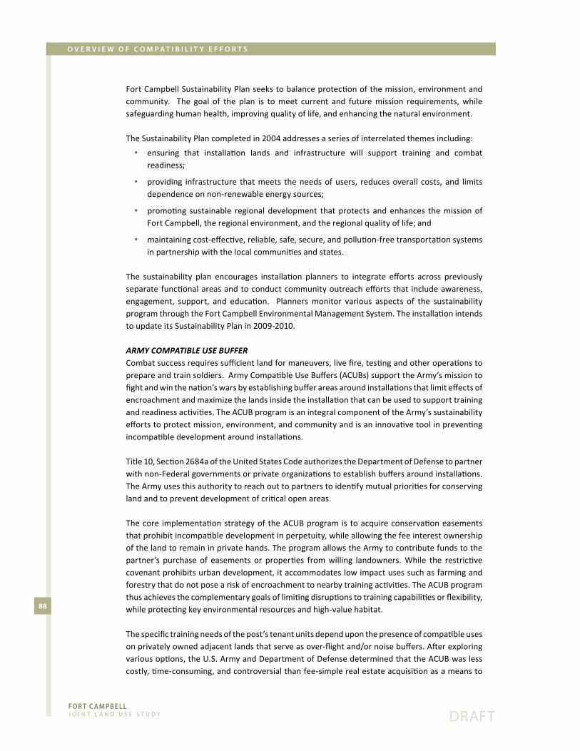
Fo R T c A m pb e l l J o i n t L a n d U s e s t U d y
88
dRaFt
o v e R v i e w o F c o m p A T i b i l i T y e F F o R T s
Fort�Campbell�Sustainability�Plan�seeks�to�balance�protection�of�the�mission,�environment�and�community.� � The� goal� of� the� plan� is� to�meet� current� and� future�mission� requirements,�while�safeguarding�human�health,�improving�quality�of�life,�and�enhancing�the�natural�environment.
The�Sustainability�Plan�completed�in�2004�addresses�a�series�of�interrelated�themes�including:
ensuring� that� installation� lands� and� infrastructure� will� support� training� and� combat� •readiness;
providing� infrastructure� that�meets� the�needs�of�users,� reduces�overall� costs,� and� limits� •dependence�on�non-renewable�energy�sources;
promoting� sustainable� regional� development� that� protects� and�enhances� the�mission�of� •Fort�Campbell,�the�regional�environment,�and�the�regional�quality�of�life;�and
maintaining�cost-effective,�reliable,�safe,�secure,�and�pollution-free�transportation�systems� •in�partnership�with�the�local�communities�and�states.
The� sustainability� plan� encourages� installation� planners� to� integrate� efforts� across� previously�separate�functional�areas�and�to�conduct�community�outreach�efforts�that� include�awareness,�engagement,� support,� and� education.� � Planners�monitor� various� aspects� of� the� sustainability�program�through�the�Fort�Campbell�Environmental�Management�System.�The�installation�intends�to�update�its�Sustainability�Plan�in�2009-2010.
aRmY Compatible use buFFeRCombat�success�requires�sufficient�land�for�maneuvers,�live�fire,�testing�and�other�operations�to�prepare�and�train�soldiers.��Army�Compatible�Use�Buffers�(ACUBs)�support�the�Army’s�mission�to�fight�and�win�the�nation’s�wars�by�establishing�buffer�areas�around�installations�that�limit�effects�of�encroachment�and�maximize�the�lands�inside�the�installation�that�can�be�used�to�support�training�and�readiness�activities.�The�ACUB�program�is�an�integral�component�of�the�Army’s�sustainability�efforts�to�protect�mission,�environment,�and�community�and�is�an�innovative�tool�in�preventing�incompatible�development�around�installations.
Title�10,�Section�2684a�of�the�United�States�Code�authorizes�the�Department�of�Defense�to�partner�with�non-Federal�governments�or�private�organizations�to�establish�buffers�around�installations.�The�Army�uses�this�authority�to�reach�out�to�partners�to�identify�mutual�priorities�for�conserving�land�and�to�prevent�development�of�critical�open�areas.�
The�core� implementation�strategy�of� the�ACUB�program� is� to�acquire�conservation�easements�that�prohibit�incompatible�development�in�perpetuity,�while�allowing�the�fee�interest�ownership�of�the�land�to�remain�in�private�hands.�The�program�allows�the�Army�to�contribute�funds�to�the�partner’s� purchase� of� easements� or� properties� from�willing� landowners.�While� the� restrictive�covenant�prohibits�urban�development,�it�accommodates�low�impact�uses�such�as�farming�and�forestry�that�do�not�pose�a�risk�of�encroachment�to�nearby�training�activities.�The�ACUB�program�thus�achieves�the�complementary�goals�of�limiting�disruptions�to�training�capabilities�or�flexibility,�while�protecting�key�environmental�resources�and�high-value�habitat.
The�specific�training�needs�of�the�post’s�tenant�units�depend�upon�the�presence�of�compatible�uses�on�privately�owned�adjacent�lands�that�serve�as�over-flight�and/or�noise�buffers.�After�exploring�various�options,�the�U.S.�Army�and�Department�of�Defense�determined�that�the�ACUB�was�less�costly,�time-consuming,�and�controversial�than�fee-simple�real�estate�acquisition�as�a�means�to�
Fo R T c A m pb e l l J o i n t L a n d U s e s t U d y
89
dRaFt
o v e R v i e w o F c o m p A T i b i l i T y e F F o R T s
Figure�21.�Army�Compatible�Use�Buffer�(ACUB)�(11�by�17�z-folded�map)�

Fo R T c A m pb e l l J o i n t L a n d U s e s t U d y
90
dRaFt
o v e R v i e w o F c o m p A T i b i l i T y e F F o R T s
Figure�21.�Army�Compatible�Use�Buffer�(ACUB)�(11�by�17�z-folded�map)�

Fo R T c A m pb e l l J o i n t L a n d U s e s t U d y
91
dRaFt
o v e R v i e w o F c o m p A T i b i l i T y e F F o R T s
reduce�encroachment.�Fort�Campbell�sought�approval�for�multi-year�funding�(beginning�in�FY06)�to�implement�an�ACUB�program�around�the�installation�(See�Figure�21).�The�program�requires�installations�to�partner�with�conservation�organizations�to�coordinate�habitat�conservation�planning�at� the�ecosystem�level.��Fort�Campbell�identified�four�ACUB�priority�areas�based�upon�the�following�criteria:�
the�land�is�in�a�high�noise�area;� •
it�is�under�or�near�a�flight�corridor;� •
it�is�within�a�1+�mile�zone�of�influence;� •
it�is�within�the�“light�sensitive”�area; •
it�is�in�the�Military�Operations�Area�that�has�been�approved�by�FAA�for�low-level�flights;�and/or •
it�has�high�conservation�value. •
The�purpose�of�ACUB�priority�#1�is�to�protect�Fort�Campbell’s�two�airfields,�CAAF�and�SAH.�The�airfields�are�vital�to�the�military�mission,�but�remain�vulnerable�to�emerging�land�use�conflicts.�The�ACUB�includes�sub-areas�created�for�each�airfield,�including�the�entire�CAAF�overflight�area.�Both�sub-areas�satisfy�all�six�criteria;� land�around�CAAF�also�features�some�of�Kentucky’s�most�fertile�farmland.�The�overall�size�of�this�priority�zone�is�approximately�9,900�acres.
ACUB�priority�#2�is�a�29,100�-acre�buffer�zone�consisting�of�a�one-mile�buffer�in�Christian�County,�KY�and�a�one-mile�buffer�in�Montgomery�County,�TN.�The�area�adjoins�US�79�and�includes�mostly�undeveloped�farmland�with�some�residential�strip�development.�This�area�is�intended�to�buffer�the�southern�flight�approaches�into�Golden�Eagle�FLS,�SAH,�and�Suckchon�Drop�Zone,�a�perimeter�flight�corridor,�and�maneuver�areas�near�the�installation�boundary�from�future�commercial�and�residential�development�along�a�widened�US�79�corridor.
ACUB�priority�#3�is�a�19,680�-acre�area�includes�a�one-mile�buffer�portion�of�Trigg�County,�KY�and�Stewart�County,�TN.�The�primary�objectives�of�ACUB�area�#3�are�to�limit�development�in�the�high�noise�zones�associated�with�the�North-South�Impact�Area�and�CAAF,�as�well�as�to�preserve�Fort�Campbell’s�primary�flight�route.�The�land�is�mainly�agricultural,�but�is�at�risk�for�conversion�to�strip�residential�development�along�county�roads�adjacent�to�the�post.
ACUB�priority�#4�is�a�40,000-acre�area�located�between�the�Land�Between�the�Lakes�Recreational�Area�and�Fort�Campbell�in�Trigg�County,�KY�and�Stewart�County,�TN.��The�zone,�which�is�largely�forest� and�agricultural� land,�has� a�high� conservation�value�due� to� the�presence�of�habitat� for�several�endangered�species.�Since�this�expansive,�privately�owned�area�is�at�somewhat�lower�risk�of�encroachment�relative�to�the�other�priority�areas,�Fort�Campbell�ACUB�Partners�will�focus�on�securing�easements�for�certain�properties�with�high�mutual�benefit.
It�should�be�noted�that�growth�just�outside�the�installation�fence�poses�only�one�type�of�risk�to�mission� viability.� The� continued� loss� and� fragmentation�of� surrounding�natural� habitat�due� to�unmanaged�development�can�also�cause�species�to�seek�out�the�remaining�intact�open�lands�on�post.��The�presence�of�threatened�and�endangered�species�on�the�installation�can�in�turn�lead�to�training�restrictions.�Fort�Campbell�is�currently�home�to�two�listed�threatened�and�endangered�species:�the�Gray�bat�(Myotis�grisescens)�and�the�Indiana�bat�(Myotis�sodalis);�and�another�four�species�of� state� concern.�While�protection�of� these� species�does�not� yet� result� in�operational�limitations,� the� continued� loss� of� nearby� habitat� places� an� additional� burden� on� the� Army� to�maintain�open�space,�thus�restricting�training�flexibility.

Fo R T c A m pb e l l J o i n t L a n d U s e s t U d y
92
dRaFt
o v e R v i e w o F c o m p A T i b i l i T y e F F o R T s
Fort� Campbell’s� training� areas� also� contain�around� 4,000� acres� of� unique� grasslands�referred� to� as� barrens� and� recognized� as� an�area�of�exceptional�ecological�importance�in�the�Interior�Low�Plateau�Ecoregion�and�some�of�the�best� remnants� of� native� grasslands� east� of� the�Mississippi�River.�Along�with�its�ACUB�partners–the� Land� Trust� for� Tennessee,� the� Kentucky�Department� of� Agriculture–Fort� Campbell�has� identified� over� 80,000� acres� around� the�installation�for�protection.�Conservation�efforts�will�likely�be�limited�to�a�relatively�small�portion�
in� the� foreseeable� future.� The� Recommendations� section� of� this� report� explores� additional�strategies�for�promoting�sustainability�partnerships�throughout�the�regional.
other regionAl PArtnershiPsIn�addition�to�addressing�its�operational�impacts,�Fort�Campbell�has�engaged�regional�partners�in�a�series�of�broader�efforts�to�coordinate�land�use�and�transportation�planning.�The�installation�inegotiated� an� exchange� of� 358� acres� of� Army� property� for� 670� acres� owned� by� Bi-County�(Montgomery� and� Stewart� Counties)� Solid� Waste� Management.� The� exchange,� completed� in�2008,�allows�Bi-County�to�expand�its�public�landfill�and�provides�Fort�Campbell�with�replacement�training�land.�
As�part�of�a�second�initiative,�the�Army�conveyed�200�acres�of�land�to�TDOT�to�facilitate�the�widening�of�Highway�79�to�four�lanes.�Under�an�MOA�updated�in�2006,�TDOT�provided�Fort�Campbell�with�$4.5�million�for�acquisition�of�replacement�property,�which�is�currently�underway.�
Fort�Campbell�also�launched�an�effort� in�2004�to�acquire�restrictive�easements�on�4,000�acres�of�privately�owned�land�adjacent�to�the�CAAF�main�approach.�The�objective�of�the�program�is�to�protect�the�main�runway�and�flight�approach�from�height�obstructions�and�incompatible�land�uses.�Currently,�the�Army�has�obtained�easements�for�92�of�96�desired�tracts.�The�Army�also�is�in�the�process�of�conveying�an�unused�portion�of�its�railroad�property�to�Hopkinsville�for�use�as�a�utility�and�recreational�corridor.�
The�Kentucky� Transportation�Cabinet� is�widening�Cole�Rd/Gate� 7� to� relieve� congestion�on�US�41A� and� to� improve� installation� access.� Fort� Campbell� is� currently� acquiring� right-of-way� and�completion�is�scheduled�for�2011.
Under�a�second�transportation/infrastructure�effort,�the�Army�is�installing�concrete�barrier�walls�along�US�41A� to�provide� security� from�potential� terrorist� attacks� and� to� serve� as� a�noise� and�privacy�barrier�for�installation�housing�areas.�The�project�is�slated�for�completion�in�2009.
Fort�Campbell,� the�Departments�of�Transportation� (DOT)� in�Kentucky�and�Tennessee,�and� the�Clarksville-Metropolitan� Planning�Organization� are� jointly� planning� the� installation� of� variable�message�boards�along�US�41A,�KY�911,�and�Tiny�Town�Road.�The�DOTs�will�primarily�use�the�boards�to� notify�motorists� of� traffic-related� events,� but� Fort� Campbell�will� also� use� them� to� provide�information�to�the�public,�such�as�access�control�point�changes�and�gate�closures.�The�projected�is�slated�for�completion�in�2009.�

Fo R T c A m pb e l l J o i n t L a n d U s e s t U d y
93
dRaFt
o v e R v i e w o F c o m p A T i b i l i T y e F F o R T s
Finally�KDOT� is�planning� reconstruction�of� the�Highway�911/115� intersection.�The�objective�of�the�project�is�to�improve�safety�and�access�to�the�installation,�as�well�as�improve�mobility�in�Oak�Grove.�Construction�began�in�late�2008.
1996 JlUs And Progress sUrvey1996 Joint lAnd Use stUdyThe� Fort� Campbell� region� was� an� early� adopter� of� coordinated� military/civilian� land� use/encroachment� prevention� planning.� In� 1996,� the� Army� and� participating� local� governments�completed�a�JLUS�for�the�surrounding�four-county�area�of�Montgomery,�Stewart,�Christian�and�Trigg�Counties.�The�study�articulated�the�following�mission�statement:
Recognizing the vital role of Fort Campbell and related facilities for the Kentucky and Tennessee communities and recognizing the vital role of Kentucky and Tennessee communities on the region, it is important that a military and community partnership is developed, which encourages balanced growth and development.
The�plan�also�established�both�community�and�military�goals,�including:�
Controlling�development�in�the�vicinity�of�Fort�Campbell�and�Outlaw�Field; •
Planning�for�the�orderly�accommodation�of�new�development; •
Minimizing�the�impact�of�growth�on�existing�development,�streets,�and�resources; •
Promoting�the�public�health,�safety,�comfort,�and�general�welfare�of�the�inhabitants�of�Fort� •Campbell,�Montgomery�County�and�Stewart�County,�Tennessee�and�Christian�County�and�Trigg�County,�Kentucky;
Restricting�land�uses�that�are�recognized�as�incompatible�in�noise�sensitive�areas�and�those� •prohibited�in�clear�zones�for�aircraft�safety;
Limiting�the�density�of�development�and�intensity�of�use�in�areas�below�the�take-off�and� •approach�flight�paths�that�are�exposed�to�significant�danger�of�aircraft�accidents;
Basing�land�use�compatibility�standards�on�noise�sensitivities;�and •
Basing�land�use�planning�and�zoning�in�the�military�environs�on�non-military�issues,�such�as� •existing�land�use�patterns�and�socio-economic�considerations.
To� achieve� these� stated� goals,� the� JLUS� recommended� a� series� of� encroachment� reduction�strategies�for�the�surrounding�communities�and�Fort�Campbell.�Tools�emphasized�included�special�purpose�zoning�to�reduce�the�exposure�of�development�to�excessive�noise�and�safety�risks,�height�restrictions� to�protect� the�navigability�of� air� space,� indoor�noise� reduction� requirements,� real�estate�disclosure,�the�coordination�of� infrastructure�policy,�and�participation�in�memoranda�of�understanding�among�affected�interests.
The� purpose� of� this� update� is� to� build� on� the� 1996� study� by� assessing� the� degree� of� partner�adherence� to� suggested� strategies� and� further� refining� recommendations� to� reflect� current�development� issues,� growth� trends,� and� changing�mission� needs.� Table� 16� illustrates� specific�recommended�actions�by�local�government�partner.
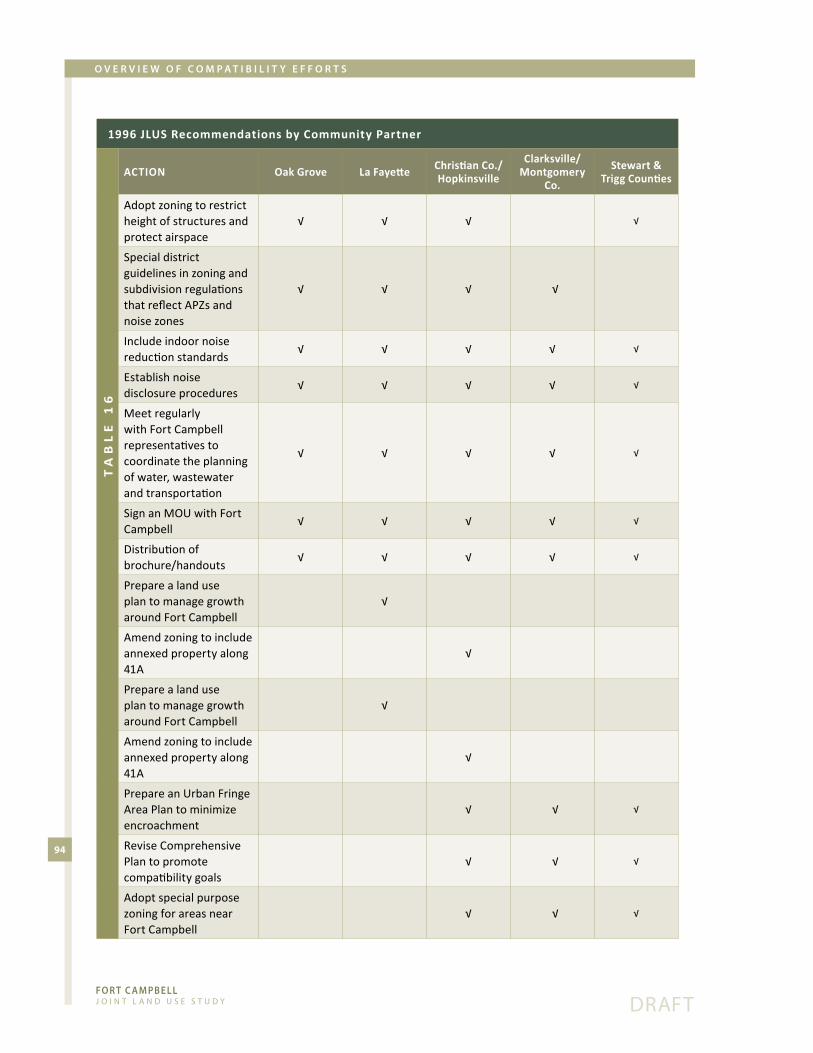
Fo R T c A m pb e l l J o i n t L a n d U s e s t U d y
94
dRaFt
o v e R v i e w o F c o m p A T i b i l i T y e F F o R T s
1996 JLUS Recommendations by Community Partner
Action Oak Grove La Fayette Christian Co./Hopkinsville
Clarksville/Montgomery
Co.
Stewart & Trigg Counties
tA
Bl
e 1
6
Adopt�zoning�to�restrict�height�of�structures�and�protect airspace
√� √� √� √
Special district guidelines�in�zoning�and�subdivision�regulations�that�reflect�APZs�and�noise�zones
√ √ √ √
Include indoor noise reduction�standards
√ √ √ √ √
Establish�noise�disclosure procedures
√ √ √ √ √
Meet�regularly�with�Fort�Campbell�representatives�to�coordinate�the�planning�of�water,�wastewater�and�transportation�
√ √ √ √ √
Sign�an�MOU�with�Fort�Campbell
√ √ √ √ √
Distribution�of�brochure/handouts
√ √ √ √ √
Prepare a land use plan�to�manage�growth�around�Fort�Campbell
√
Amend�zoning�to�include�annexed�property�along�41A
√
Prepare a land use plan�to�manage�growth�around�Fort�Campbell
√
Amend�zoning�to�include�annexed�property�along�41A
√
Prepare�an�Urban�Fringe�Area�Plan�to�minimize�encroachment
√ √ √
Revise�Comprehensive�Plan to promote compatibility�goals
√ √ √
Adopt�special�purpose�zoning�for�areas�near�Fort�Campbell
√ √ √

Fo R T c A m pb e l l J o i n t L a n d U s e s t U d y
95
dRaFt
o v e R v i e w o F c o m p A T i b i l i T y e F F o R T s
The�1996�report�recommended�the�following�recommendations�for�Fort�Campbell�to:
Developing�a�procedure�for�managing�noise�complaints •
Developing�an�easy�to�understand�brochure�on�noise�impacts •
Providing� cities� with� periodic� updates� on� studies� being� conducted� to� reduce� building� •vibration�from�blast�noise
Making�data�from�noise�monitors�available�to�public�officials�and�planning�agencies •
Establishing�a�waiver�on�the�firing�of�artillery�on�Sundays�from�9�AM�to�Noon�(Lafayette,�KY) •
Meeting� regularly�with� community� representatives� to� coordinate� the� planning� of�water,� •wastewater�and�transportation�
Signing�an�MOU�with�affected�local�governments •
Relocating�the�NAVAID�at�CAAF •
Clearly�delineating�installation�boundary�in�the�vicinity�of�Lafayette,�KY •
Using�Explosive�Research�Group�evaluation�of�good/bad�firing�conditions�to�reduce�complaints •
Securing�avigation�easements�&�noise�agreements�on�properties�surrounding�Fort�Campbell •
Fort�Campbell�has�complied�with�seven�of�the�1996�recommendations�including:�managing�noise�complaints;�developing�an�outreach�brochure;�periodically�briefing�cities;�participating�in�MOUs;�relocating�NAVAID;�evaluating�firing�conditions;�and�securing�avigation�easements.
JlUs Progress sUrvey To� assess� the� priorities� of� decision-makers� and� to� determine� the� effectiveness� of� previous�compatibility�actions,�as�well�as�interest�in�exploring�new�anti-encroachment�tools,�the�planning�team� administered� a� short� JLUS� Progress� Survey� to� members� of� the� Executive� Committee.�Members�of�the�Technical�Coordinating�Committee�also�provided�responses.��Tables�17�and�18�display�the�results�of�the�survey.
The�survey�asked�respondents�to�answer�the�following�questions�on�a�scale�of�1�to�4�with�a�score�of�1�indicating�a�weak�response�and�4�indicating�a�strong�response.��All�respondents�recognized�Fort�Campbell�as�a�significant�economic�driver�of�the�region.�Both�committees�viewed�the�level�of�collaboration�and�communication�between�Fort�Campbell�and�local�governments�as�moderately�strong,� though� Technical� members� tended� to� rate� the� strength� of� the� military/community�relationship� slightly� higher.� Technical� Committee� members� believed� that� existing� community�policies� have� been� more� effective� in� limiting� incompatible� growth� than� their� senior� official�counterparts.��Respondents�indicated�relatively�limited�concern�in�the�surrounding�communities�about�noise�and�other�operational� impacts,�but� suggested� the�need� for� increased�community�awareness�of�the�constraints�that�incompatible�growth�can�impose�on�the�military�mission.
The� survey� then� asked� respondents� to� evaluate� the� need� for� exploring� a� series� of� possible�strategies�to�promote�compatible�land�uses�around�the�installation.��A�score�of�1�indicates�no�need�to�pursue�a�particular�tool�and�a�score�of�4�indicates�a�strong�need.��All�respondents�viewed�land�use�and�zoning�controls�as�an�essential�tool� in�managing�encroachment.� �Technical�Committee�members�also�placed�strong�emphasis�on�outdoor�lighting�standards�to�protect�the�night�vision�training�device�environment.��Improved�communication�and�regional�coordination,�the�use�of�real�estate�disclosures�and�the�securing�of�conservation�easements�scored�favorably.��The�Executive�

Fo R T c A m pb e l l J o i n t L a n d U s e s t U d y
96
dRaFt
o v e R v i e w o F c o m p A T i b i l i T y e F F o R T s
Committee�saw�less�value�in�the�direct�acquisition�of�land�by�the�Army,�indoor�noise�reduction�requirements,�and�controls�on�transportation�improvements.
cUrrent locAl government comPAtiBility tools The�local�governments�surrounding�Fort�Campbell�have�adopted�various�measures�to�promote�compatible�land�use�around�the�installation.�The�major�encroachment�reductions�implemented�by�community�to�date�are:
stewArt coUntyThe�County�has�signed�an�MOU�with�Fort�Campbell;�increased�emphasis�on�implementation� •of�the�MOU�is�recommended�
trigg coUntyThe�County�has�signed�an�MOU�with�Fort�Campbell;�increased�emphasis�on�implementation� •of�the�MOU�is�recommended�
The�Trigg�County�Planning�Commission�attaches�noise�warnings�to�plats�within�an�established� •distance�from�the�installation
Progress Survey Results, Question Responses
QUESTIONExecutive
Committee Avg. Score
Technical Coordinating Committee Avg. Score
tA
Bl
e 1
7
1.�How�would�you�characterize�the�overall�level�of�collaboration�between�your�community�and�Fort�Campbell?
3 3.5
2.�How�would�you�characterize�the�level�of�communication�between�your�local�community�and�Fort�Campbell?
3.2 3.5
3.�How�important�is�the�continued�mission�of�Ft�Campbell�to�your�community�in�terms�of�sustaining�economic�growth�and�job�creation?
4 3.8
4. How�effective�do�you�think�that�existing�community�policies�have�been�in�limiting�incompatible�growth�around�the�installation?
2.8 3.3
5. What�is�the�level�of�concern�in�your�community about noise or other impacts generated�by�operations�and�training�activities�at�Fort�Campbell?
2.4 2.8
6. What�is�the�level�of�awareness�in�your�community�about�the�effects�of�incompatible�development�on�the�Fort�Campbell�mission?
2.4 2.7

Fo R T c A m pb e l l J o i n t L a n d U s e s t U d y
97
dRaFt
o v e R v i e w o F c o m p A T i b i l i T y e F F o R T s
oAk groveThe�city�has�signed�an�MOU�with�Fort�Campbell�and�implemented�its�provisions� •
City�agencies�send�development�plans�to�Fort�Campbell�for�review�as�though�it�were�another� •city department
Oak�Grove�passed�a�lighting�ordinance�for�41A�in�August�of�2007;�the�ordinance�requires� •that�all�lighting�installed�along�the�corridor�face�downward
The�city�adopted�a�sign�ordinance�in�2008�regulating�the�height�of�signs •
hoPkinsvilleThe�city�has�signed�an�MOU�with�Fort�Campbell�and�implemented�its�provisions� •
Hopkinsville�has�adopted�a�military�overlay�district�that�includes�height�restrictions,�noise� •standards,�and�exterior�lighting�design�criteria�
Hopkinsville�grants�the�Army�an�opportunity�for�site/subdivision�review�and�comment� •
christiAn coUntyThe�county�has�signed�an�MOU�with�Fort�Campbell�and�implemented�its�provisions •
The�MOU�also�requires�plats�in�noise�zones�to�carry�noise�warnings •
The�county�allows�the�installation�an�opportunity�to�review�development�proposals�in�south� •Christian�County
The�county�has�incorporated�supportive�compatibility�language�into�their� •Comprehensive�Plan�
Christian�County�supported�the�State’s�enactment�of�the�KY�Airport�Zoning�around�CAAF •
clArksville/montgomery coUntyClarksville/Montgomery�County�has�signed�an�MOU�with�Fort�Campbell�and�implemented� •its�provisions
The�county�planning�commission�grants� the�Army�site/subdivision� review�within�a�+one- •mile�buffer�of�the�installation
Progress Survey Results, Question Responses Ranking of Possible Compatibility Tools
tool Executive Committee Avg. Score
Technical Coordinating Committee Avg. Score
tA
Bl
e 1
8
Land�use/zoning 3.4 3.8
Improved�communication�with�military 3.3 3.6
Conservation�easements 3.0 3.4
Acquisition�of�land�by�the�Army 2.0 3.6
Real estate disclosure 3.2 3.2
Outdoor�lighting�standards 3.2 3.8
Improved�regional�coordination 3.0 3.2
Indoor�noise�reduction�standards 2.3 3.0
Controls�on�infrastructure�improvements 2.8 3.0
Controls�on�transportation�improvements 3.2 3.6

Fo R T c A m pb e l l J o i n t L a n d U s e s t U d y
98
dRaFt
o v e R v i e w o F c o m p A T i b i l i T y e F F o R T s
Clarksville/Montgomery�has�adopted�the�Sabre�Heliport�Overlay�District�ordinance,�which� •regulates�land�use�and�lighting�design�criteria�within�the�Aircraft�Light�Sensitive�Area,�Noise�Zones,�Military�Noise�Disclosure�Areas,�and�Approach�Departure�Surface�Areas
The� ordinance� requires� noise� level� reduction� for� new� residences,� offices,� churches,� and� •schools�built�in�Noise�Zones�2�and�3
In�the�Military�Noise�Disclosure�Area,�all�subdivision�plats�and�site�review�plans�require� •disclosure
Also,�building�permit�applicants�must�sign�a�noise�disclosure�stating�that�premises�may�be� •exposed�to�excessive�noise�levels�from�the�heliport�in�Noise�Zones�2�and�3
Clarksville�has�updated�the�comprehensive�plan�to�reflect�compatibility�with�Fort�Campbell;� •specific�language�includes:
It was deemed important by the Coordinating Committee to maintain lower level of residential
development in the areas surrounding Fort Campbell because of problems with noise and
light pollution. Residential development is adversely affected by the bright lights associated
with development which could interfere with night flight training exercises. Reference should
be made to the Joint Land Use Study of 1996.
Clarksville�is�in�the�process�of�revamping�zoning�districts�to�incorporate�smart�growth�and� •compact�development;�these�are�tools�that�can�enhance�the�ability�to�manage�growth�in�transitional�areas�near�the�installation
The� Growth� Plan� encourages� higher� density� residential,� commercial,� and� industrial� •development�in�an�Urban�Growth�Boundary�contiguous�with�the�City�of�Clarksville;�designated�Planned� Growth� Areas� are� appropriate� for� low� to� moderate� density� growth;� the� plan�designates�rural�areas�outside�the�Urban�Growth�Boundary�and�the�Planned�Growth�Areas;�these�plans�facilitate�land�use�compatibility�with�the�military�mission�and�reduce�the�risk�of�encroachment�by�guiding�new�growth�away�from�rural�areas�in�proximity�to�the�installation�
It�should�be�emphasized�that�Fort�Campbell�and�the�partner�communities�of�the�JLUS�maintain�a�close�and�collaborative�relationship.��As�evident�from�the�list�of�actions�taken,�local�governments�are�planning�proactively�to�protect�the�mission�viability�of�the�post�and�to�reduce�the�exposure�of�residents�to�noise,�air�safety�hazards,�and�other�operational�impacts.�However,�the�review�of�current�policy�also�suggests�key�gaps�in�compatibility�planning,�including�the�lack�of�appropriate�zoning�in�Trigg,�Christian�and�Stewart�Counties.�The�recommendations�of�this�report�focus�on�strengthening�the�encroachment�reduction�tools�available�to�local�planners�and�decision-makers.
FederAl And stAte initiAtives SUSTAINABLE�RANGE�PROGRAMThe�Department�of�Defense�(DoD)�developed�the�Sustainable�Range�Program�(SRP)�to�give�Army�installations�access�to�an�array�of�planning,�facilities�management,�environmental�management,�munitions�management,� and� safety� program� tools.� The� SRP� is� a� comprehensive� approach� to�improve�the�way�the�Army�plans,�manages,�and�uses�its�ranges�in�support�of�long-term�viability,�more�efficient�and�effective�training,�and�reduced�demands�on�scarce�resources,�such�as�land,�air,�water,�and�energy.��The�SRP�includes�several�major�efforts:�
The�Range�and�Training�Land�Program�(RTLP)�plans�for�the�safe�day-to-day�management�of� •range�lands�and�enhanced�training�performance;�

Fo R T c A m pb e l l J o i n t L a n d U s e s t U d y
99
dRaFt
o v e R v i e w o F c o m p A T i b i l i T y e F F o R T s
The�Integrated�Training�Area�Management�(ITAM)�Program�seeks�to�achieve�the�optimum� •use� of� lands� for� combat� realistic� training� through� planning,� rehabilitation,�maintenance,�mapping,�assessment,�and�monitoring;�and�
The� Readiness� and� Environmental� Protection� Initiative� (REPI)� is� a� collaborative� effort� to� •reduce�the�risk�of�encroachment�from�off-post�activity�as�described�below.
reAdiness And environmentAl Protection initiAtiveOnce�specifically�sited�in�remote�areas,�military�installations�are�now�often�in�the�path�of�advancing�exurban�development�or�have�generated�external�growth�through�spin-off�economic�activities.��Over�the�past�decade,�the�DoD�has�increasingly�recognized�encroachment�as�a�major�constraint�in�safely�and�effectively�carrying�out�the�training�and�readiness�activities�of�the�military.��
In�an�effort�to�protect�the�future�use�of�installations�and�training�land,�the�FY2003�National�Defense�Authorization�Act�authorized�the�Military�Services�(Army,�Navy,�Marine�Corps�and�Air�Force)�to�enter�into�agreements�with�non-federal�conservation�organizations�to�acquire�real�estate�in�the�vicinity�of�military� installations�such�as�bases,�posts�and�forts.� �The�statutory�authority�can�be�found�in�the�United�States�Code�at�10�U.S.C.�2648a.
The�Readiness� and� Environmental� Protection� Initiative� (REPI)� grants� the�military� the� ability� to�enter� into� agreements� with� eligible� entities,� such� as� local� governments,� non-governmental�organizations,� and�willing� land� owners� to� secure� conservation� easements� on� property� in� the�vicinity� of,� or� ecologically� related� to,� a� military� installation� or� military� airspace.� � The� Army�implements�REPI�strategies�through�the�Army�Compatible�Use�Buffer�program�described�earlier.�The�agreements�enable�private�organizations� to�acquire,�on�a� cost-shared�basis,�development�interests�in�the�properties�of�voluntary�sellers.�The�property�owner�typically�continues�to�hold�the� title� for� the� land,� but� receives� monetary� compensation� and� tax� breaks� to� maintain� the�encumbered�property�in�a�highly�limited�use�that�preserves�habitat�and�avoids�interference�with�the�operational�procedures�of�the�nearby�installation.��REPI�is�the�fastest�growing�conservation-based�program�in�the�federal�government�today.
The�DoD�has�also�formed�a�partnership�with�the�United�States�Department�of�Agriculture�(USDA)�to�conserve�sensitive�lands�near�military�bases�around�the�nation.�Through�the�USDA,�installation�ACUB�planners�can�now�access�the�resources�of�existing�easement�programs,�such�as�the�Farm�and�Ranch�Lands�Protection�Program,�the�Wetlands�Reserve�Program,�and�the�Grassland�Reserve�Program.�The�DoD’s�promotion�of�conservation�and�integrated�planning�enhances�the�choice�of�encroachment� reduction� tools� available� to� today’s� installations� and�defense� communities� and�supplements�smart�growth�land�use�strategies�pursued�by�many�local�governments.��
stAte initiAtivesComplementing�federal�policy�efforts,�states�have�increasingly�mandated�collaborative�planning�among�military�installations�and�local�governments.�The�State�of�Kentucky,�for�example,�requires�local� planning� entities� to� consult� with� the� military� commander� of� any� installation� within� its�jurisdiction�to�assess�issues�related�to:
installation�expansion; •
the�environment; •
installation�safety;�and� •
airspace�usage,�to�include�noise�pollution,�air�pollution,�and�air�safety�concerns. •
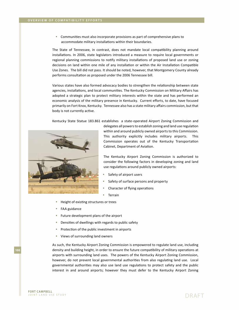
Fo R T c A m pb e l l J o i n t L a n d U s e s t U d y
100
dRaFt
o v e R v i e w o F c o m p A T i b i l i T y e F F o R T s
Communities�must�also�incorporate�provisions�as�part�of�comprehensive�plans�to� •accommodate�military�installations�within�their�boundaries.
The� State� of� Tennessee,� in� contrast,� does� not� mandate� local� compatibility� planning� around�installations.� In�2006,� state� legislators� introduced�a�measure� to� require� local� governments�or�regional� planning� commissions� to�notify�military� installations�of� proposed� land�use�or� zoning�decisions�on� land�within�one�mile�of�any� installation�or�within� the�Air� Installation�Compatible�Use�Zones.��The�bill�did�not�pass.�It�should�be�noted,�however,�that�Montgomery�County�already�performs�consultation�as�proposed�under�the�2006�Tennessee�bill.
Various�states�have�also�formed�advocacy�bodies�to�strengthen�the�relationship�between�state�agencies,�installations,�and�local�communities.�The�Kentucky�Commission�on�Military�Affairs�has�adopted� a� strategic� plan� to� protect�military� interests�within� the� state� and�has� performed� an�economic�analysis�of�the�military�presence�in�Kentucky.��Current�efforts,�to�date,�have�focused�primarily�on�Fort�Knox,�Kentucky.��Tennessee�also�has�a�state�military�affairs�commission,�but�that�body�is�not�currently�active.�
Kentucky� State� Statue� 183.861� establishes� � a� state-operated�Airport� Zoning� Commission� and�delegates�all�powers�to�establish�zoning�and�land�use�regulation�within�and�around�publicly�owned�airports�to�this�Commission.��This� authority� explicitly� includes� military� airports.� � This�Commission� operates� out� of� the� Kentucky� Transportation�Cabinet,�Department�of�Aviation.
The� Kentucky� Airport� Zoning� Commission� is� authorized� to�consider� the� following� factors� in�developing� zoning�and� land�use�regulations�around�publicly�owned�airports:
Safety�of�airport�users •
Safety�of�surface�persons�and�property •
Character�of�flying�operations •
Terrain •
Height�of�existing�structures�or�trees •
FAA�guidance •
Future�development�plans�of�the�airport •
Densities�of�dwellings�with�regards�to�public�safety •
Protection�of�the�public�investment�in�airports •
Views�of�surrounding�land�owners •
As�such,�the�Kentucky�Airport�Zoning�Commission�is�empowered�to�regulate�land�use,�including�density�and�building�height,�in�order�to�ensure�the�future�compatibility�of�military�operations�at�airports�with�surrounding�land�uses.��The�powers�of�the�Kentucky�Airport�Zoning�Commission,�however,�do�not�prevent� local� governmental�authorities� from�also� regulating� land�use.� � Local�governmental� authorities�may� also� use� land� use� regulations� to� protect� safety� and� the� public�interest� in� and� around� airports;� however� they� must� defer� to� the� Kentucky� Airport� Zoning�

7.0 Compatibility tools

Fo R T c A m pb e l l J o i n t L a n d U s e s t U d y

Fo R T c A m pb e l l J o i n t L a n d U s e s t U d y
103
dRaFt
c o m p A T i b i l i T y T o o l s
overviewThe�JLUS�Update�document�is�intended�as�a�series�of�tools�that�the�Army�and�the�local�governments�can�choose�to�adopt�during�the� implementation�phase�of�the�JLUS�process.� �All�of� the�entities�participating�in�the�JLUS,�including�the�Army�and�cities�and�counties,�retain�the�responsibility�of�selecting�those�compatibility�tools�that�best�reflect�the�specific� issues,�concerns,�and�needs�of�each stakeholder.
The� tools� identified� below� are� the� result� of� a� thorough,� good-faith� effort� on� the� part� of� the�Technical�Coordinating�Committee�(TCC)�and�the�Executive�Committee�(EC)�to�assess�the�existing�and�foreseeable�effects�of�Fort�Campbell,�Campbell�Army�Airfield�(CAAF),�and�Sabre�Army�Heliport�(SAH)�on�adjacent�land�and�to�develop�a�set�of�options�that�promote�collaborative�regional�decision-making�and�balance�community�and�military�interests�while�meeting�the�following�goals:
Protect the military mission •
Protect�the�health,�safety�and�welfare�of�the�military�and�civilian�communities •
Sustain�economic�development�and�protect�property�rights •
Protect�the�environment� •
Tailor�options�to�each�community� •
Secure�proper�funding�and�administrative�resources�for�implementation •
Maintain�political�feasibility •
This�section�organizes�findings�into�two�parts:�
An�overview�of�available�encroachment�reduction�strategies1.
A�prioritized�list�of�feasible�encroachment�reduction�measures2.
The� supporting� Appendices� include� land� use� compatibility� guidelines,� specific� examples� of�recommended�ordinances,�agreements,�and�public�outreach�materials.
AvAilABle encroAchment redUction strAtegiesThe�TCC�evaluated�a�wide�range�of�tools�based�on�criteria�such�as:�feasibility;�likely�effectiveness;�the�availability�of�resources�for�implementation;�the�ability�to�protect�the�military�mission�and�installation�sustainability;�the�ability�to�protect�the�economic�health�of�the�region�and�individual�property�rights;�and�the�overall�ability�to�protect�health,�safety,�welfare,�and�quality�of�life.
The� tools� are� also� intended� to� address� a� variety� of� possible� land� use� and� operational� issues,�including�physical�adjacency�to�Fort�Campbell/CAAF/SAH,�conservation�or�natural�resource�value,�noise,�air�safety�(both�for�people�on�the�ground�and�for�aviators),�and�light�pollution.
The�descriptions�below�include�strategies�that�may�not�yet�be�fully�feasible�in�the�Fort�Campbell�region,� but� have� value� as� long-term� approaches� to� minimizing� incompatible� development�around�the�installation.�In�other�cases,�the�participating�entities�have�partially�adopted�available�strategies� and� the� prioritized� recommendations� focus� on� enhancing� these� current�measures.��As�development�conditions�and�mission�impacts�evolve,�the�JLUS�encourages�local�officials�and�planners�to�revisit�this�list�of�strategies�to�further�refine�and�strengthen�their�set�of�encroachment�reduction�tools.

Fo R T c A m pb e l l J o i n t L a n d U s e s t U d y
104
dRaFt
c o m p A T i b i l i T y T o o l s
conservAtionConservation�refers�to�a�series�of�tools�designed�to�eliminate�land�use�incompatibilities�through�voluntary�transactions�in�the�real�estate�market�and�local�development�process.��These�strategies�are�particularly�effective�because�they�advance�the�complementary�goals�of�shifting�future�growth�away�from�the�installation,�while�protecting�the�environment�and�wildlife�habitats,�maintaining�agriculture/silviculture,�and�conserving�open�spaces�and�rural�character.�
As�part�of�this�strategy,�Fort�Campbell�has�partnered�with�the�Land�Trust�for�Tennessee�and�the�Kentucky�Department�of�Agriculture�to�explore�the�purchase�of�conservation�easements�from�willing� property� owners�within� priority� acquisition� areas� identified�by� the�Army�Compatible�Use� Buffer� (ACUB)� study� completed� in� August� 2005.� The� Army� has� identified� priority� areas�near� CAAF� and� other� lands� to� the� north� and� south� of� the� installation.� The� ACUB� program�has� emerged� as� one� of� the� most� effective� of� the� sustainability� initiatives� in� preventing�encroachment� around� installations.� The� core� implementation� strategy� of� the� program� is� to�acquire�conservation�easements�that�prohibit�incompatible�development�in�perpetuity,�while�allowing� the� land� to� remain� in�private�hands.�While� the� restrictive�covenant�prohibits�urban�development,�it�accommodates�low�impact�uses�such�as�farming�and�forestry�that�do�not�pose�a�risk�of�interference�with�nearby�training�activities
Local�governments�can�participate� in�the�conservation�process�by�acting�as�direct�cost-sharing�partners� in� conservation� easement� purchases� or� by� aligning� their� infrastructure� and� land� use�policy�to�reinforce�the�rural/agricultural�character�of�areas�near�or�within�the�designated�ACUB.��The�prioritized�actions�identify�specific�complementary�roles�for�adjacent�local�governments�in�the� acquisition� of� development� rights� or� the� use� of� quality� growth� strategies� to� direct� public�services�and�new�growth�away�from�undeveloped�areas�in�proximity�to�the�installation.�
ZoningZoning�requires�activities,�such�as�industry,�retail,�recreation,�agriculture,�and�very�low�density/rural� residential� that� maintain� compatibility� with� post� and� airfield� operations.� � Compatible�activities�generally�avoid� the�concentration�of�people�and�show� lower�sensitivity� to�noise�and�other�possible�operational�impacts.��Zoning�typically�also�regulates�the�effects�of�private�land�uses�on�nearby�military�training�by,� for�example,�minimizing� light�pollution�or� limiting�the�height�of�structures�that�may�interfere�with�navigable�airspace.�As�part�of�this�strategy,�local�governments�would�create�a�specialized�Military�Activity�Zoning�District�that�governs�uses�within�established�noise�zones�contours�and�Accident�Potential�Zones.
While� several� jurisdictions,� including� the� City� of� Oak� Grove,� the� City� of� Hopkinsville,� and�Clarksville-Montgomery�County�have�zoning�procedures� in�place�to�promote�the�compatibility�of�development�near�military�activity,�unincorporated�portions�of�adjacent�counties,�particularly�to�the�north�and�southwest�of�the�post,�are�not�subject�to�comparable�land�use�controls�under�a�county-wide�zoning�ordinance.�Currently,�Christian,�Trigg,�and�Stewart�Counties�do�not�have�county-wide�zoning�in�place.
The� JLUS� emphasizes� that� county-wide� zoning� in� Christian,� Trigg� and� Stewart� Counties� is� an�effective�and�desirable�long-term�strategy�for�managing�eventual�residential�and�commercial�growth� around� the� installation,� as� well� as� promoting� quality,� cost-efficient� development�throughout�the�counties.�
Fo R T c A m pb e l l J o i n t L a n d U s e s t U d y
105
dRaFt
c o m p A T i b i l i T y T o o l s
Figure�22.�Fort�Campbell�Activity�Zones�(11�by�17�z-folded�map)�

Fo R T c A m pb e l l J o i n t L a n d U s e s t U d y
106
dRaFt
c o m p A T i b i l i T y T o o l s
Figure�22.�Fort�Campbell�Activity�Zones�(11�by�17�z-folded�map)�
Fo R T c A m pb e l l J o i n t L a n d U s e s t U d y
107
dRaFt
c o m p A T i b i l i T y T o o l s
Appendix�H�contains�a�model�ordinance�for�possible�zoning�districts�around�Fort�Campbell.��The�ordinance�divides�land�into�three�zones�based�upon�the�level�of�impact�from�military�operations�and� then� regulates� residential� density,� intensity� of� non-residential� uses,� building� height,� and�exterior�lighting,�and�requires�indoor�noise�attenuation�and�real�estate�disclosure.
Three�districts�are�established�for�the�Fort�Campbell�Activity�Zones�(FCAZ):��FCAZ�I,�FCAZ�II,�and�FCAZ�III.��FCAZ�I�includes�the�Clear�Zones�and�Accident�Potential�Zone�I�associated�with�Campbell�Army�Airfield.��FCAZ�II�includes�Accident�Potential�Zones�II�and�all�areas�within�the�noise�zone�LDN�70�(see�the�Compatible�Use�Buffer�Area�on�Figure�22).��FCAZ�III�includes�all�land�inside�the�JLUS�Area�of�Concern.�Regulations�are�the�most�restrictive�in�FCAZ�I�and�relax�for�FCAZ�II�and�III.
While�this�section�identifies�zoning�as�a�long-term�strategy�that�warrants�ongoing�consideration�by�local�officials�and�residents,�the�list�of�prioritized�actions�below�explores�near-term�alternative�land�use�policies�that�can�assist�in�reducing�emerging�conflicts�at�the�community/military�interface,�as�well�as�other�mechanisms�for�addressing�lighting�and�height�issue�. sUBdivision regUlAtionsEven�communities�without�zoning�often�have�subdivisions�regulations�at�the�engineering�and�site�planning�stage�in�the�development�process�that�govern�the�size,�shape,�configuration,�orientation�and�utility�access� for�a� tract�of� land�or�an� individual� lot.�Special�environmental�considerations�have�become�accepted�as�part�of�the�subdivision�development�process�and�are�justified�under�the�delegated�police�powers�to�protect�the�public�health,�safety,�and�general�welfare.
In�the�interest�of�protecting�public�health�and�safety,�a�subdivision�regulation�may�prohibit�the�subdividing�of�property�into�residential�lots�if�the�tract�is�within�a�designated�AICUZ�high�noise�zone�recognized�by�the�local�approving�authority�as�the�maximum�threshold�for�intrusive�noise.�Similarly,�commonly�used�local�police�powers�can�prohibit�the�subdivision�of�land�into�residential�building�lots�if�the�subject�property�is�in�one�of�the�more�restrictive�air�safety�zones,�such�as�a�Clear�Zone�or�Accident�Potential�Zone�I.�
noise AttenUAtion Attenuation� refers� to� special�design�and�construction�practices� intended� to� lower� the�amount�of� noise� and� vibration� that� penetrates� the� windows,� doors,� and� walls� of� a� building.� Local�governments�should�require�attenuation�as�part�of�building�code�enforcement�for�new�residential�and�other�noise�sensitive�construction�in�certain�noise�affected�areas�(typically� in�excess�of�60�dB).�Attenuation�practices�are�most�effective�for�areas�subject�to�A-weighted�noise,�generated�by�aviation�activity.� �Air�operations�are� the�major�source�of�noise�affecting�surrounding� lands.�Both�the�City�of�Hopkinsville�and�Clarksville-Montgomery�County�have�adopted�noise�reduction�standards�for�development�in�proximity�to�CAAF�and�SAH.
Sound� attenuation� guidelines� are� available� in� the� latest� advisory� document� on: Guidelines for Sound Insulation of Residences Exposed to Aircraft Operations, 2005.
reAl estAte disclosUreDisclosure�requires�the�release�of�information�on�possible�impacts�(dust,�smoke,�noise/vibration,�air�safety�zones)�to�prospective�buyers�or�renters�as�part�of�real�estate�transactions�for�properties�close� to� Fort� Campbell/CAAF/SAH� (i.e.� inside� the� JLUS� Area� of� Concern).� � Local� governments�

Fo R T c A m pb e l l J o i n t L a n d U s e s t U d y
108
dRaFt
c o m p A T i b i l i T y T o o l s
would�implement�this�tool�by�adopting�a�local�real�estate�disclosure�ordinance�and�seeking�the�participation�of�real�estate�professionals.��
Clarksville-Montgomery�County�requires�that�building�permit�applicants�sign�a�noise�disclosure�stating�that�premises�may�be�exposed�to�excessive�noise�levels�from�the�heliport�in�Noise�Zones�2�and�3.
Appendix�C�contains�a�sample�real�estate�disclosure�form�and�real�estate�disclosure�ordinance.
AvigAtion eAsementsAn�avigation�easement�is�a�form�of�disclosure�aimed�at�the�developer,�rather�than�the�individual�buyer,�during�the�initial�stages�of�platting.�An�easement�is�the�right�granted�to�a�third�person�to�use�private� real� property� in� a� specified�manner.�An�easement�may�be� given,� for� example,� for�overhead�wires,�underground�gas,�power,�sewer�or�storm�drain�lines,�and�sidewalks�or�roads.�A�noise�easement�is�a�property�right�acquired�from�a�land�owner�that�grants�the�right�of�military�training�activities�in�proximity�to�the�affected�parcel,�including�the�right�to:�
cause�noise,�vibration,�dust,�etc. •
restrict�or�prohibit�certain�lights,�electromagnetic�signals,�or�land�uses�that�could�interfere� •with�communications�technology�and�safe�aircraft�operation;�and
ensure�unobstructed�airspace�over�the�property�above�a�specified�height •
The�easement�runs�in�perpetuity�with�the�deed�to�the�property.�Local�governments�increasingly�rely�on�such�easements�to�protect�military�operations�against�encroachment�from�nearby�developing�areas.��Local�governments,�for�example,�may�establish�the�granting�of�a�noise�easement�by�the�developer�as�a�condition�for�the�approval�of�a�proposed�new�home�subdivision�in�areas�subject�to�military�training�impacts,�such�as�a�high�noise�zone�or�Accident�Potential�Zone.��
Appendix�D�contains�a�sample�avigation�easement�form.
comPrehensive PlAnsAs�part�of�this�option,�local�governments�would�include�specific�language�on�JLUS�coordination�as�part�of�Comprehensive�Plan�development�or�update.��The�Comprehensive�Plan�establishes�a�firm�legal�basis�for�the�implementation�of�compatibility�actions�and�sets�the�policy�framework�to�regulate�development�through�local�land�use�regulations.
The�plan�can�emphasize�the�relationship�between�the�community�and�the�military,�the�desire�to�promote�cooperative�land�use�planning�and�complementary�land�use�goals,�such�as�agricultural�conservation�and�environmental�protection,�and�clear�guidelines�about�appropriate�future�land�use�in�areas�vulnerable�to�encroachment.
An�increasingly�popular�strategy�is�for�local�governments�to�develop�a�Military�Influence�Planning�District�(MIPD)�Element�within�the�Comprehensive�Plan.��This�element�is�devoted�exclusively�to�the�collaborative�relationship�between�the�local�government�and�military�installation�and�integrates�all� policies� that�may�promote� compatible�development,� including� communication�procedures,�conservation�and�land�use�policy,�and�transportation�and�infrastructure�policy.
Appendix�F�contains�sample�Comprehensive�Plan�language.

Fo R T c A m pb e l l J o i n t L a n d U s e s t U d y
109
dRaFt
c o m p A T i b i l i T y T o o l s
inFrAstrUctUreThe�provision�of�infrastructure�is�typically�based�on�public�need�and�necessity�and�reflects�the�Comprehensive� Plan� of� the� city� or� county.� As� part� of� this� strategy,� local� governments�would�consider�the�impacts�of�both�public�and�private�infrastructure�installation/extension�(e.g.�water�and�sewer�facilities)�into�noise�and�safety�affected�areas�around�Fort�Campbell/CAAF/SAH.��New�infrastructure�can� induce�or�support� incompatible�growth�patterns,� such�as�denser� residential�development,�especially�if�compatible�zoning�and�land�use�guidelines�are�not�in�place.�
Since�capital�investment�decisions�in�turn�influence�private�market�location�decisions,�it�is�critical�that�local�governments�link�their�Work�Programs�and�Capital�Improvement�Plans�to�compatibility�goals.� Installing� infrastructure� such� as� water,� sewer� and� roads� in� planned� growth� areas� and�away� from� areas� of� operational� impact� clearly� reduces� the� conflicts� associated� with� denser�development�near�the�installation.�Regional�Transportation�Improvement�Plans�(TIP)�should�also�reflect�the�need�to�limit�road�capacity�projects�in�areas�near�the�installation�where�development�can� interfere�with� the�military�mission.� � Community�officials� should�also� consult�with�military�installation�planners�as�part�of�the�local�planning�and�facilities�programming�decisions.
commUnicAtion Under�this�approach,�participating�jurisdictions�would�develop�appropriate�mechanisms�to�ensure�that�residents,�developers,�businesses,�and�local�decision-makers�have�adequate�information�about�Army�operations,�possible�impacts�on�lands�surrounding�Fort�Campbell/CAAF/SAH,�procedures�to�submit�comments,�and�any�additional�local�measures�to�promote�land�use�compatibility�around�the�installation.��Governments�should�use�all�available�media,�including�posters,�brochures,�and�city�and�county�web�sites�to�convey�the�information.
In�addition�to�the�actions�of�the�local�governments�to�communicate�the�impacts�of�Fort�Campbell/CAAF/SAH,� the� Area� Development� Districts� and� Regional� Councils� should� post�maps� on� their�websites�of�properties�within� the�designated�noise,� safety� and�planning�buffers.� � Ideally,� land�owners,�developers,� and�prospective� renters�or�buyers� could�access�a� searchable�database�of�properties�in�these�areas.��
Similarly,�the�Army�would�build�on�existing�communication�with�its�neighbors�through�methods�such� as� publishing� planned� training� schedules� (training� schedules� change� day-to-day)� and�operational�guidelines� for�night� training�on� the�post�web�site;�ensuring�a� continued� role� for�a�highly�visible�Fort�Campbell�liaison�to�address�noise�and�other�issues�and�brief�the�communities;�and�updating�the�brochure/poster�on�post�mission�and�activities,�operational�impacts�and�mapped�noise�contours,�and�other�compatibility�issues.
coordinAtionUnder�this�approach,�local�governments�would�promote�collaboration�by�sharing�information�on�specific�community�development�proposals�(rezonings�and�subdivisions)�within�designated�buffers�around�Fort�Campbell/CAAF/SAH.���Several�local�governments�(the�City�of�Oak�Grove,�the�City�of�Hopkinsville,�Clarksville-Montgomery�County,�Christian�County)�have�established�procedures�for�consulting�military�representatives�regarding�development�activity�within�a�designated�buffer�of�the�installation�(typically�one�mile).

Fo R T c A m pb e l l J o i n t L a n d U s e s t U d y
110
dRaFt
c o m p A T i b i l i T y T o o l s
It� should� be� noted� that� only� the� local� government�can� approve� or� disapprove� zoning� and� subdivision�proposals.� Fort� Campbell� consults� strictly� on� an�advisory� basis.� Recommendations� would� enhance�such�coordination�by�including�jurisdictions�that�have�not�yet�established�a�comparable�consultation�process�and�by�encompassing�all�property�within�the�JLUS�Area�of�Concern.
A�Memorandum�of�Understanding� (MOU)� is� a� “good�faith”�document�that�further�establishes�procedures�for�communication�among�affected�parties�and�formalizes�
collaboration�among�multiple�stakeholders.�Several�jurisdictions�currently�have�active�MOUs�in�place�with�Fort�Campbell,� including�the�City�of�Oak�Grove,�the�City�of�Hopkinsville,�Clarksville/Montgomery� County,� and� Christian� County.� � Prioritized� actions� suggest� enhancing� existing�agreements�to�include�additional�provisions�related�to�lighting,�conservation,�and�infrastructure�extensions�and�broadening�participating�entities�to�include�all�counties�around�the�installation,�as�well�as�Departments�of�Transportation�and�local�utility�providers.
Appendix�E�contains�examples�of�MOUs.
clUstering Clustering�can�be�an�effective�tool�in�promoting�land�use�compatibility�around�a�military�installation,�particularly� on� larger� parcels� that� straddle� a� noise� or� safety� boundary.�Under� clustering� (also�known�as�conservation�design),�developers�can�separate�the�buildable�areas�of�the�parcel�from�areas�that�have�a�development�constraint,�such�as�noise�or�safety�risk�exposure.�The�district�then�allows�more�compact�lots�in�the�developable�portion�of�the�site�in�exchange�for�the�permanent�protection�of� land� in�the�constrained�area.�This�essentially�becomes�a�density-neutral� transfer�of�development�rights�onto�another�portion�of�the�same�parcel�outside�of�areas�adjacent�to�the�post,� targeted�conservation�areas�or�designated�noise�or�air�safety�zones.� �Also�as�part�of�this�strategy,� local�governments�could�require�developers� to�use� low� impact�site�design�principles,�including� the� creation� of� green� space/conservation� buffers� that� can� support� noise� and� safety�impact�mitigation.
trAnsFer oF develoPment rightsLocal�governments�could�also�pursue�a�pure�transfer�of�development�rights�(TDR)�program,�which�shifts�growth�from�a�designated�“sending�area”�with�development�constraints�(noise�or�air�safety�zones,�areas�adjacent�to�the�post,�conservation�buffers)�to�a�designated�“receiving�area”�that�does�not�have�site�limitations.�This�transaction�takes�place�voluntarily�in�the�free�market.�The�owner�of�the�constrained�land�sells�the�development�credits�established�under�zoning�to�a�buyer�who�then�can�develop�additional�residential�density�on�another�property�based�on�the�number�of�credits�purchased.�Both�Kentucky�(KSR�100.208�Transferable�development�rights)�and�Tennessee�state�laws�grant� local� governments� the�authority� to� adopt� a� local� TDR�program.� � This�option�poses�more�of� an�administrative� challenge� than� the� simple� clustering�of�houses�and� requires� strong�market�pressures�for�development�combined�with�a�limited�supply�of�available�land.��Given�the�relatively�rural�character�of�the�region,�a�TDR�program�is�not�be�feasible�tool�in�the�near-term,�but�may�have�long-term�applicability�in�select�areas,�particularly�in�Clarksville-Montgomery�County�as�population�growth�continues.

Fo R T c A m pb e l l J o i n t L a n d U s e s t U d y
111
dRaFt
c o m p A T i b i l i T y T o o l s
oUtdoor lighting stAndArdsWhile�military�flight�operations�generate�noise�and�pose�a�statistically�measurable,�albeit� low,�safety�risk�to�surrounding�areas,�nearby�civilian�uses�can,�in�turn,�produce�conditions�that�interfere�with� aircraft� operations.� � Among� the�most� common� of� these� hazards� stems� from� the� use� of�excessive�and�unshielded�outdoor�lighting.�Outdoor�lighting�systems,�especially�lighting�associated�with�billboards,�gas�stations,�major�roadways,�athletic�fields,�and�large�commercial�or�industrial�uses�often�allow�significant�light�to�travel�upward�into�an�otherwise�darkened�sky.�The�resulting�“light�pollution”�can�obscure�pilot�vision�or�interfere�with�the�use�of�night�vision�training�devices.��
Clarksville/Montgomery�has�established�the�Sabre�Heliport�Overlay�District�ordinance,�which�regulates�design� criteria�within� the�Aircraft�Light� Sensitive�Area�and� the�City�of�Hopkinsville�adopted� lighting�design� criteria� in�1999�as�part�of� its� zoning�overlay.� The�City�of�Oak�Grove�adopted� an� ordinance� for� outdoor� lighting� standards� in� August� of� 2007.� The� consistent�application�of�exterior�lighting�standards�around�the�installation�is�critical�for�maintaining�the�safety�of�aviation�operations.
Appendix�G�contains�two�models�of�proposed�outdoor�lighting�regulations.
PrioritiZed list oF encroAchment redUction meAsUresAs�noted�earlier,�the�four�surrounding�counties�have�adopted�some�of�the�best�compatibility�practices� available� to� defense� communities� throughout� the� country.� A� review� of� current�measures,�however,� indicates�critical�gaps�in�the�region’s�encroachment�reduction�approach,�both�in�the�form�of�geographic�areas�that�remain�unregulated�and�or�in�existing�policies�that�require�stronger�provisions.
The� following� is� a� list�of� feasible,�near-term�measures�developed�on� the�basis�of� the�planning�team’s� compatibility� findings� and� feedback� from� area� stakeholders� and� officials.� While� the�communities�and�the�Army�should�continue�to�broaden�and�refine�their�array�of�compatibility�planning�tools,�these�high�priority�actions�seek�to�address�the�most�pressing�land�use�conflicts�around�Fort�Campbell.
1. AdoPt oUtdoor lighting stAndArds to Protect the night vision device environment From light intrUsion
Previous�descriptions�of�Fort�Campbell’s�military�mission�emphasize�that�the�installation�is�one�of�the�most�intensively�used�night-time�training�facilities�in�the�U.S.�Army.��Continued�community�growth,� particularly� along�Highway� 41A� and�Highway� 79� in� the� vicinity� of� CAAF� and� SAH�will�continue�to�exacerbate�current�issues�of�overlighting�and�unshielded�lighting.�The�resulting�light�pollution� adversely� affects� night� vision� device� (NVD)� operation� and� could� curtail� future� night�time�training�and�readiness�activities�at�the�post.� �Regulations�that�minimize� interference�with�the�NVD�environment�do�not�require�the�strict�prohibition�of�exterior�lighting�or�the�complete�replacement� of� existing� lighting� fixtures.� Instead,� regulations� focus� on� installing� less� intrusive�lighting� applications� either� for� new� development� or� as� part� of� the� routine� maintenance/replacement�of�public�utilities.�

Fo R T c A m pb e l l J o i n t L a n d U s e s t U d y
112
dRaFt
c o m p A T i b i l i T y T o o l s
Local�governments�and�Fort�Campbell�have�two�options�for�implementing�exterior lighting�standards:
A�zoning-based�method�that�regulates�the�performance�of�new�lighting�applications�within� •a�geographically�targeted�area,�through�a�zoning�overlay�district
Use�of�building�permit�process�as�the�regulatory�vehicle�to�control�poor�quality�exterior�lighting •
1.a Zoning based lighting RegulationsBased�upon�analysis�of�planning�team�members�assessing�the�night�vision�device�environment,�a�regionally-based�model�lighting�ordinance�with�standards�for�the�following�property�types�and�facilities�would�be�the�most�effective�tools�for�protecting�aviator�and�overall�safety.
Commercial�applications� •Utility�company�provided�residential�lighting�systems •Public�streets,�roads�and�highways •Public structures •Fort�Campbell •Signs •Temporary�lighting •
The�supporting�Appendix�contains�a�model�lighting�ordinance�that�requires�fully�shielded�lighting�applications�for�new�non-residential�uses�within�the�designated�Night�Vision�Devise�(NVD)�Lighting�Zones�(See�Figure�23).��
This� model� is� intended� as� an� interim� ordinance� that� local� governments� can� readily� adapt� to�conform� to� the�National�Model� Lighting�Ordinance� (MLO)�now�being�developed� jointly�by� the�Illuminating�Engineering�Society�and�the�International�Dark�Sky�Association.��
The�ordinance�proposes�two�zones�as�shown�on�Figure�23.��These�zones�are�intended�to�encompass�all� property� in� proximity� to� airfield� operations� and� the� post’s� low� level� flight� corridors.� � The�proposed�ordinance�refers�to�this�area�as�the�“Night�Vision�Device�(NVD)�Influence�Area.”��The�recommended�NVD�Influence�Area�includes�the�following�features:
flight�approaches�of�SAH�&�CAAF •primary�flight�corridors�surrounding�the�installation •Fort�Campbell�Zone�of�Influence •key�interchanges�in�close�proximity�to�Fort�Campbell�and/or�major�aviation�routes •existing�light-sensitive�zones�(SUD-41A,�SAH�Overlay�&�Oak�Grove�Lighting�Ordinance) •
The�boundary�of�the�NVD�zone�is�tied�to�nearby�local�roads�or�other�easily-identifiable�features�to�ease�identification�of�regulated�areas.
All� unzoned� land�or� property� zoned� for� agricultural� and� residential� uses�within� this� boundary�defaults� to� Lighting� Zone� 2� (LZ2).� � All� other� zoned� property,� including� commercial,� industrial�and�institutional�uses�falls�under�the�standards�set�for�Lighting�Zone�3�(LZ3).� �Property�owners�may�request�a�re-designation�to�a�higher�and�therefore�less�stringent�lighting�zone�as�part�of�the�rezoning�or�development�process.
LZ 2. • ��Low-density�suburban�and�urban�neighborhoods�and�suburban�commercial�districts.��This�zone�is�intended�to�be�the�default�condition�for�suburban�areas.

Fo R T c A m pb e l l J o i n t L a n d U s e s t U d y
113
dRaFt
c o m p A T i b i l i T y T o o l s
Figure� 23.�Night-Vision�Device� Lighting� Zones� (11�by�17�z-folded�map)�

Fo R T c A m pb e l l J o i n t L a n d U s e s t U d y
114
dRaFt
c o m p A T i b i l i T y T o o l s
Figure� 23.�Night-Vision�Device� Lighting� Zones� (11�by�17�z-folded�map)�
Fo R T c A m pb e l l J o i n t L a n d U s e s t U d y
115
dRaFt
c o m p A T i b i l i T y T o o l s
LZ 3. • ��Medium�to�high-density�urban�neighborhoods�and�districts,�shopping�and�commercial�districts,�industrial�parks�and�districts.��This�zone�is�intended�to�apply�only�to�Central�Business�District(s)�and�areas�having�unique�character�such�as�auto�malls.
The�ordinance�is�a�prescriptive-based�code�that�regulates�the�installation�of�new�lighting�systems,�modifications�to�existing�lighting�systems�or�the�replacement�of�lighting�fixtures�for�non-residential�uses,� common�residential�areas�and�street� lights.�Property�owners�outside�of� these�zones�are�encouraged,�but�not�required�to�comply�with�the�lighting�provisions.�
See�Appendix�G�for�two�sample�model�ordinances.��The�Tier�1�ordinance�is�intended�to�address�the�immediate�need�for�preventing�improper�lighting�practices�that�lead�to�uplighting.��A�more�comprehensive� ordinance� sample� appropriate� for� mid-� to� long-implementation� by� partner�jurisdictions�includes�provisions�to�control�the�impacts�of�unshielded�and�overly�intense�lighting,�as�well�as�reduce�light�trespass�on�neighboring�properties.�
1.b building Code based RegulationsJurisdictions�that�lack�the�formal�powers�to�enact�land�use�regulatory�language�based�on�zoning�ordinances�can�use�the�building�permit�process�as�the�regulatory�vehicle�to�control�poor�quality�exterior� lighting.� � Local� governments� would� require� that� site� plans� submitted� as� part� of� the�commercial,� industrial,� and�multi-family�permitting�process� include� information�on� the�design�of�outdoor�lighting�to�be�installed�in�the�project.�Failure�to�comply�with�the�requirement�for�fully�shielded�lighting�would�result�in�a�building�denial�or�a�required�modification�of�lighting�practices�prior�to�permit�approval.�
In�addition�to�developing�regulatory��or�code�enforcement�tools�to�promote�the�use�of�shielded�lighting� applications� within� the� Night� Vision� Devise� Influence� Area,� local� communities� should�continue�to�conduct�an�aggressive�outreach�campaign�to�educate�business�owners,�developers,�and� representatives� from� State� Departments� of� Transportation� and� local� utilities� about� the�importance�of�installing�less�intrusive�lighting�fixtures.�Street�lighting�in�particular�is�an�ongoing�source�of�light�pollution.�The�integration�of�shielded�fixture�designs�in�roadway�projects�can�play�a�major�role�in�reducing�night�sky�degradation.��Similarly,�private�utility�companies�often�provide�property�owners�with�security�and�agricultural�lighting.��The�distribution�of�more�sensitive�lighting�applications�within�the�surrounding�four-county�area�would�also�assist�in�eliminating�sporadic�light�intrusion�inside�and�outside�of�the�Night�Vision�Device�Influence�Area.��A�later�recommendation�includes�examples�of�agreements�with�transportation�and�utility�officials� intended�to�reinforce�their�cooperation.
Appendix� G� contains� a� series� of� supporting� documents� to� facilitate� community� outreach� on�lighting�issues:�an�Ordinance�narrative�intended�for�use�as�a�handout�to�members�of�the�public;�Sample�Lighting�Applications�by�User�Type;�and�International�Dark-Sky�Association�Information�Sheets�on�topics�such�as�billboards,�gas�stations,�sports�lighting,�towers,�canopy�lighting,�cobra�head�style�lighting,�full�cut�off�fixtures,�and�good�and�bad�lighting�examples.�
2. control develoPment density in the comPAtiBle Use BUFFer AreA At cAAF
The� JLUS� compatibility� analysis� has� identified� the� Compatible�Use� Buffer� to� the� northwest� of�Campbell�Army�Airfield�as�the�most�critical�area�around�the�installation�to�protect�from�future�residential�and�intensive�commercial�growth.��The�buffer�as�shown�on�Figure�24�includes�land�that�

Fo R T c A m pb e l l J o i n t L a n d U s e s t U d y
116
dRaFt
c o m p A T i b i l i T y T o o l s
falls�within�the�70�dB�noise�contours,�the�Accident�Potential�Zone�I�and�Accident�Potential�Zone�II�associated�with�the�north-south�CAAF�runway,�and�the�previously�secured�avigation�easements�for�property�under�the�primary�runway�oriented�to�the�northeast�of�CAAF.
Land� use� compatibility� guidelines� from� the� Department� of� Defense� suggest� that�multi-family�homes�or�single-family�housing�in�excess�of�one�dwelling�unit�per�acre�may�pose�a�conflict�with�the�noise�and�air�safety�risks�associated�with�nearby�aircraft�operations.��Any�housing�construction�in�this�zone�should�also�incorporate�indoor�noise�reduction�practices.�The�guidelines�indicate�that�less�people-intensive�non-residential�uses,�such�as�warehousing,�agriculture,�and�very�small�scale�retail�may�be�an�appropriate�fit.��Certain�noise�sensitive�uses�and/or�uses�that�concentrate�people,�such�as�schools,�churches,�and�medical�facilities�are�particularly�vulnerable�to�the�risks�of�aircraft�operation�and�are�accordingly�deemed�incompatible.��These�lower�residential�densities�are�also�desirable�for�maintaining�the�rural�agricultural�character�of�this�area.
Typically,�local�communities�can�regulate�the�size,�intensity�or�type�of�land�use�in�a�specific�area�through� zoning� procedures.� The� Compatible� Use� Buffer� at� CAAF� falls� within� unincorporated�Christian� County,� which� does� not� currently� exercise� zoning� authority.� � As� noted� earlier,�comprehensive� county-wide� zoning� would� be� the� most� effective� local� vehicle� for� preventing�incompatible�development�around�Fort�Campbell�and�promoting�quality�growth�outcomes.�� The� county,� however,� has� several� policy� tools� available� to� restrict� future� development� in� the�Compatible�Use�Buffer�without�county-wide�zoning.��Feasible�near-term�options�include:
Limiting� the� public� extension� of� centralized� wastewater� services� into� the� designated� •Compatible�Use�Buffer;�or
Restricting�the�subdivision�of�land�for�residential�purposes�in�a�higher�noise�zone�or�Accident� •Potential�Zone�based�on�a�public�health,�safety,�and�general�welfare�provision
limitations on Wastewater treatment infrastructure extensionsThe�provision�of�sewer�capacity�has�the�well-documented�effect�of�physically�shaping�a�community’s�growth�patterns�and�supporting�more�intense�development�within�its�service�areas.�While�land�in� the� Compatible�Use� Buffer� is� currently�without� access� to� centralized�wastewater� lines,� the�eventual�extension�of�such�infrastructure�could�facilitate�land�subdivision�and�development.��This�strategy�does�not�recommend�a�prohibition�of�central�system�connections�to�privately�financed�infrastructure�installations,�but�instead�urges�local�utility�authorities�to�minimize�publically�funded�improvements� that� could� have� the� unintended� result� of� inducing� incompatible� development�near� Fort� Campbell.� � Limitations� on� access� to� public� sewer� specifically�within� the� Compatible�Use�Buffer�(See�Figure�24)�would�alter�the�economics�of�land�development�(making�development�more�costly�and�thus�less�appealing�to�developers)�and�require�larger�lots�to�support�individual�septic�systems,�thus�effectively�capping�potential�residential�density.
The�county�could�put�this�strategy�in�place�by�developing�infrastructure�extension�guidelines�for�the�Hopkinsville�Water� Environment�Authority� and� the�Oak�Grove�Water�District� that� restrict�public�expenditures�for�the�installation�of�new�sewer�lines�in�the�Compatible�Use�Buffer.
public safety subdivision Regulation provisionsEven�without� zoning,� the� local� subdivision� process� commonly� includes� special� environmental�considerations�that�protect�the�public�health,�safety,�and�general�welfare�of�the�community�based�on�delegated�police�powers.��Regulations�could,�for�example,�deny�approval�for�the�subdivision�

Fo R T c A m pb e l l J o i n t L a n d U s e s t U d y
117
dRaFt
c o m p A T i b i l i T y T o o l s
Figure� 24.� CAAF� Sub-Area� Future� Compatibility�Scenario�(11�by�17�z-folded�map)�

Fo R T c A m pb e l l J o i n t L a n d U s e s t U d y
118
dRaFt
c o m p A T i b i l i T y T o o l s
Figure� 24.� CAAF� Sub-Area� Future� Compatibility�Scenario�(11�by�17�z-folded�map)�
Fo R T c A m pb e l l J o i n t L a n d U s e s t U d y
119
dRaFt
c o m p A T i b i l i T y T o o l s
of� land� for� residential�purposes� in�areas�with�characteristics�such�as� the�floodplain�of�streams�and� rivers�and� steep�or�unstable� slopes.� � The� regulations�could� therefore� justifiably� recognize�the�inherent�risk�of�placing�housing�in�proximity�to�active�aviation�operations�by�adding�similar�provisions�to�prohibit�the�creation�of�individual�housing�lots�within�a�designated�high�noise�zone�(deemed�as�70�dB+)�and�within�a�designated�APZ-I.
industrial mega-siteAlong�with�protecting� the�Compatible�Use�Buffer,� local�officials� should�ensure� that� any� future�development�of�the�industrial�mega-site�follows�several�development�conditions�to�minimize�the�risk�of�air�safety�conflicts,�including:�
prohibiting�the�manufacture�or�storage�of�chemical�and�hazardous�materials�on�the�site; •
prohibiting� the� use� of� the� site� in� any� manner� that� creates� electrical� interference� with� •navigational�signals�or�radio�communication�between�CAAF�and�aircraft;
prohibiting�the�use�of�the�site�in�any�manner�that�interferes�with�aviator�vision,�including� •any�type�of�reflective/glare-producing�building�exterior;�unshielded,�high-intensity�exterior�lighting�or�signage;�highly�reflective�surface�lot�or�roadway�materials;�smoke,�gas�or�steam�emissions
prohibiting�any� site�elements�or� land�uses� that�may�attract�birds�or�water� fowl,� such�as� •water�features�or�landfills;
�enforcing�consistency�with�existing�CAAF�easement�conditions�on�the�site; •
minimizing� the�placement�of� structures�or� labor-intensive�activities� in�Accident�Potential� •Zone�1�(APZ�I);�site�design�should�set�a�maximum�total�lot�coverage�of�20�percent;�establish�a�one-story�maximum�for�any�buildings;�and�direct�activities�that�concentrate�employees�during�regular�shift�hours�away�from�APZ�I
If�the�industrial�mega�site�anchors�a�major�economic�generator,�such�as�an�automobile�assembly�site,� it� could� also� spur� ancillary� development� in� the� form� of� suppliers,� supporting� retail,� and�workforce�housing.�Local�officials�should�prepare�for�such� induced�development�by� identifying�suitable�growth�areas�away�from�the�noise�zones�and�active�airspace�associated�with�CAAF.��
3. control develoPment density in the rUrAl PlAnning AreA west oF sAh
The�Clarksville/Montgomery�Sabre�Heliport�Overlay�District�ordinance�effectively�governs� land�use� in� the�Compatible�Use�Buffer� that�encompasses�noise�contours� from�the�airfield�and� land�that�is�in�close�proximity�to�the�installation�boundary�north�of�the�old�Highway�79�alignment.�The�ordinance�regulates�development�and�lighting,�requires�disclosure�and�indoor�sound�attenuation,�and�restricts�structure�height�in�Approach�and�Departure�Surface�Areas.
This�recommendation�instead�focuses�on�an�area�of�the�county�to�the�west�of�State�Road�233,�shown�as�the�Rural�Planning�Area�on�Figure�25.��New�roadway�capacity�along�Highway�79�will�very�likely�induce�commercial�growth�and�residential�subdivisions�along�this�corridor�in�the�years�ahead.�
Clarksville/Montgomery�currently�designates�this�area�as�rural�because�it�is�outside�of�the�Urban�Growth�Boundary�and�the�Planned�Growth�Areas.��The�city/county�should�seek�to�preserve�the�rural�character�of� this�area�even�as�market�conditions�evolve�by�directing�future�development�back�to�land�that�is�contiguous�with�existing�development�and�public�infrastructure.��Under�quality�

Fo R T c A m pb e l l J o i n t L a n d U s e s t U d y
120
dRaFt
c o m p A T i b i l i T y T o o l s
growth�planning,�mixed�use�nodes�and�traditionally�designed�neighborhoods�in�Planned�Growth�Areas�could�readily�absorb�future�population�increases,�while�relieving�pressures�to�develop�on�the�urban�fringe.�
All� infrastructure,� land� use,� and� environmental� protection� policies� should�work� in� concert� to�reinforce� this� critical�boundary�and�minimize� scattered� residential� and� commercial� uses� along�Highway� 79.� � Future� development� permitted� in� this� area� should� not� exceed� more� than� one�dwelling�unit�per�acre�and�should�fully�comply�with�measures�to�reduce�night�sky�degradation�from�exterior�lighting�sources.
4. condUct corridor mAnAgement stUdies Along highwAy 41A And highwAy 79
Growth�along�Highway�41A�between�Oak�Grove�and�Hopkinsville�and�on�Highway�79�west�of�Liberty�Church�Road�represents�the�most�significant�foreseeable�land�use�compatibility�threat�to� Fort� Campbell.� � Early� access�management� along� developing� corridors� is� one� of� the�most�effective�mechanisms�for�controlling�the�vehicular,�aesthetic,�and�development�impacts�of�strip�commercial�activity.�
Access� management� entails� the� coordination� of� driveway� design� and� spacing,� median� openings,�interchanges,�traffic�lights,�and�street�connections.� �The�primary�purpose�of�the�management�plan�is� to� create�access� for� future� land�development,�while�preserving� the� safety�and�efficiency�of� the�transportation�system.� �The�State�of�Kentucky�has� implemented�an�Access�Management�Program.�Tennessee�has�less�comprehensive�regulations�controlling�driveway�spacing�on�interstate�highways. While�access�management�efforts�are�mainly�geared�toward�easing�the�flow�of�vehicular�traffic,�corridor�management�plans�can�also�include�a�land�use�and�design�component.��As�part�of�this�broader�effort,�participating�stakeholders�can�develop�a�long-term�vision�for�the�corridor�under�study�and�identify�supporting�land�use�policies�to�cluster�development�at�key�intersections�and�to�protect�open�space�along�strategic�stretches�of�the�roadway.��Active�planning�is�essential�to�counteract� the�common�market�tendency�to�evenly�spread� low�density�commercial� in�a� linear�pattern�along�road�frontage.��Adherence� to� quality� growth� principles� could,� for� example,� reinforce� green� space� separators�between� communities� such� as� Hopkinsville� and� Oak� Grove� and� guide� new� commercial� uses�toward�designated�activity�nodes�at�major� intersections�contiguous�with�developed�areas�and�existing�infrastructure.�This�nodal,�rather�than�linear,�form�of�growth�could�reduce�commercial�activity�near�CAAF�and�SAH�and�along� the� installation’s� southern�boundary.�Corridor�planning�efforts�are�best�conducted�as�a�regional�and�multi-jurisdictional�process�that�includes�all�affected�communities�and�their�key�stakeholders.
5. exPAnd coordinAtion And commUnicAtion Policies For develoPment within the JlUs AreA oF concern
Communities� should� continue�or�expand� the�use�of� two�essential� communication�practices� to�maintain�an�ongoing�dialogue�about�compatibility�among� local�governments,� the�military,�and�affected�private�property�owners:
Consultation�with�Fort�Campbell�military�planners�on�development�proposals;�and� •
Area�of�Military�Impact�notification�on�plats. •

Fo R T c A m pb e l l J o i n t L a n d U s e s t U d y
121
dRaFt
c o m p A T i b i l i T y T o o l s
Figure� 25.� Sabre� Sub-Area� Future� Compatibility�Scenario�(11�by�17�z-folded)�

Fo R T c A m pb e l l J o i n t L a n d U s e s t U d y
122
dRaFt
c o m p A T i b i l i T y T o o l s
Figure� 25.� Sabre� Sub-Area� Future� Compatibility�Scenario�(11�by�17�z-folded)�

Fo R T c A m pb e l l J o i n t L a n d U s e s t U d y
123
dRaFt
c o m p A T i b i l i T y T o o l s
development Consultation While� communities� to� the� east� of� Fort� Campbell,� including� Christian� County,� Clarksville-Montgomery,�Hopkinsville,�and�Oak�Grove�have�established�procedures�for�consulting�with�Fort�Campbell�on�proposed�development�activity�near�the�installation,�Trigg�and�Stewart�Counties�do�not�have�comparable�mechanisms�for�seeking�input�on�the�possible�effects�of�adjacent�development�on�the�military�mission.��As�development�pressure�increases�and�spreads�west,�Trigg�and�Stewart�Counties� should� regularly� consult� with� Fort� Campbell� military� planners� on� plans� for� major�residential�subdivisions�(i.e.� in�excess�of�five�housing�units)�and� large�commercial�and� industrial�uses.��The�intent�is�not�to�require�the�review�of�all�development�projects,�but�to�ensure�adequate�coordination�on�new�planned�communities,�retail�plazas,�industrial�parks�and�other�large�land�users�that�may�concentrate�people�or�generate�secondary�issues�such�as�light�intrusion.��Consultation�is�recommended�only�for�those�proposed�developments�inside�the�JLUS�Area�of�Concern.
Local�governments�to�the�east�of�the�installation�should�continue�to�consult�with�Fort�Campbell�regarding�development�proposals�for�land�inside�the�JLUS�Area�of�Concern.��This�consultation�would�include�property�designated�as�part�of�the�JLUS�Coordination�Area�shown�in�Figures�24�and�25.
area of military impact plat notificationIn�addition�to�promoting�coordination�between�the�community�and�military�sectors,�local�officials�should� ensure� that� property� owners� receive� adequate� information� on� the� impacts� of� nearby�military�activity.��At�a�minimum,�all�plats�inside�the�Area�of�Concern�should�contain�language�on�possible�exposure�to�noise�and�military�overflights.
6. continUe And exPAnd regionAl coordinAtion The�stakeholders�of�the�region�have�a�history�of�collaboration�dating�back�more�than�a�decade�to�the�1996�Joint�Land�Use�Study�effort.� �Community�representatives�meet�as�part�of�the�JLUS�Partnership� and�Fort�Campbell� conducts� regular�briefings� for� civilian�officials�on� compatibility�and� conservation� projects� and�mission-related� activities.� � This� JLUS� effort� strongly� urges� the�continuance�of� these�regional� forums�on�approximately�a�bi-annual�basis� to�maintain�an�open�dialogue�between�military�and�community�leaders�and�planners.�It�is�also�critical�that�communities�that�have�been�previously�less�engaged�in�the�joint�planning�process�designate�a�clear�point�of�contact�to�interact�consistently�with�Fort�Campbell�military�planners.
The�JLUS�Partnership�should�also�consider�updating�its�charter�to�reflect�emerging�issues�related�to�transportation�and�utilities�infrastructure,�regional�waste,�and�regional�development.
7. continUe to imProve overAll commUnicAtionUnder� this� approach,� participating� jurisdictions� would� ensure� that� residents,� developers,�businesses,� and� local� decision-makers� have� adequate� information� about� Army� operations,�possible�impacts�on�lands�surrounding�Fort�Campbell/CAAF/SAH,�procedures�to�submit�comments,�and�any�additional� local�measures� to�promote� land�use�compatibility�around� the� installations.��Governments�should�use�all�available�media,�including�posters,�brochures,�and�city�and�county�web�sites�to�convey�the�information.
In�addition�to�the�actions�of�the�local�governments�to�communicate�impacts�of�Fort�Campbell/CAAF/SAH,� the� Area� Development� Districts� and� Regional� Councils� should� post�maps� on� their�

Fo R T c A m pb e l l J o i n t L a n d U s e s t U d y
124
dRaFt
c o m p A T i b i l i T y T o o l s
websites�of�properties�within� the�designated�noise,� safety� and�planning�buffers.� � Ideally,� land�owners,�developers,� and�prospective� renters�or�buyers� could�access�a� searchable�database�of�properties�in�these�areas.��
Similarly,� the� Army� would� maintain� and� improve� communication� with� its� neighbors� through�methods�such�as�publishing�planned�training�schedules� (training�schedules�change�day-to-day)�and�operational�guidelines�for�night�training�on�the�post�web�site;�continuing�a�role�for�a�highly�visible�Fort�Campbell�liaison�to�address�noise�and�other�issues�in�the�community;�and�creating�a�brochure/poster�on�post�mission�and�activities,�operational�impacts�and�mapped�noise�contours,�and�other�compatibility�issues.
8. strengthen And exPAnd memorAndA oF UnderstAnding with regionAl stAkeholders
Several�local�governments�have�signed�memoranda�of�understanding�(MOUs)�with�Fort�Campbell�laying�out�procedures�for�sharing�information�and�promoting�land�use�compatibility�around�the�installation.��These�agreements,�though�not�binding,�are�essential�for�maintaining�continuity�in�regional�actions�to�reduce�encroachment.�
The�JLUS�recommends�that�local�governments�that�have�previously�participated�in�MOUs�revisit�their� agreements� and� sign� a�more� robust� document� that� specifically� references� designated�Compatible�Use�Buffer�Areas�and�additional�policies�related�to�conservation�and�sustainability�partnerships,�exterior�lighting�controls,�and�public�infrastructure�improvements.��The�Appendix�contains�an�example�of�a�Tier�1�MOU�intended�for�communities�such�as�Clarksville-Montgomery�County,� the�City�of�Oak�Grove,� and� the�City�of�Hopkinsville.� �A�more�basic� Tier�2�MOU� (see�Appendix)�is�appropriate�for�local�governments,�such�as�Trigg�County�and�Stewart�County�that�have�less�severe�compatibility�issues�and�growth�pressures�to�address.��Trigg�County�and�Stewart�County,�however,�should�be�more�aggressive�in�carrying�out�the�provisions�of�previously�signed�MOUs�and�in�identifying�a�clear�point�of�contact�to�assist�in�coordinating�compatibility�issues�with�Fort�Campbell�and�participating�in�ongoing�regional�initiatives.�
While� local� governments� are� typically� the� signatories� on� such� MOUs,� the� JLUS� also�recommends�that�Fort�Campbell�seek�similar�agreements�with�other�regional�partners�whose�cooperation� is� essential� in�minimizing� incompatible� development.� � The�Appendix� contains�examples�of�MOUs�appropriate�for�representatives�of�state�Departments�of�Transportation�and�Metropolitan�Planning�Organizations�(MOU-DOTs/ADDs/MPOs)�and�local�utilities�(MOU-UTILITIES).� �These�MOUs�address� issues�related�to�public� infrastructure� improvements�and�outdoor�lighting�applications.
9. exPlore stAte comPAtiBility meAsUresState�legislatures�may�choose�to�pass�legislation�to�require,�by�local�planning�statute,�compatible�land�use�plans�that�support�the�readiness�missions�of�a�nearby�military� installation.�The�State�of�Kentucky,�for�example,�has�a�statutorily�enabled�(KRS�183.861)�Kentucky�Airport�Zoning�Commission�and�delegates�all�powers�to�establish�zoning�and� land�use�regulation�within�and�around�publicly�owned� airports� to� this� Commission.� � This� authority� explicitly� includes� military� airports.� � This�Commission�operates�out�of�the�Kentucky�Transportation�Cabinet,�Department�of�Aviation.
Fo R T c A m pb e l l J o i n t L a n d U s e s t U d y
125
dRaFt
c o m p A T i b i l i T y T o o l s
The� Kentucky� Airport� Zoning� Commission� is� authorized� to� consider� the� following� factors� in�developing�zoning�and�land�use�regulations�around�publicly�owned�airports:
Safety�of�airport�users •Safety�of�surface�persons�and�property •Character�of�flying�operations •Terrain •Height�of�existing�structures�or�trees •FAA�guidance •Future�development�plans�of�the�airport •Densities�of�dwellings�with�regards�to�public�safety •Protection�of�the�public�investment�in�airports •
Views�of�surrounding�land�owners •
As�such,�the�Kentucky�Airport�Zoning�Commission�is�empowered�to�regulate�land�use,�including�density�and�building�height,� in�order� to�ensure� the� future�compatibility�of�military�operations�at�airports�with�surrounding�land�uses.��The�Commission�could�be�requested�to�enact�land�use�regulations�in�order�to�enforce�the�recommendations�of�the�JLUS�study.
The� powers� of� the� Kentucky� Airport� Zoning� Commission,� however,� do� not� prevent� local�governmental� authorities� from� also� regulating� land� use.� � Local� governmental� authorities�may�also�use� land�use� regulations� to�protect� safety�and�the�public� interest� in�and�around�airports;�however�they�must�defer�to�the�Kentucky�Airport�Zoning�Commission�where�the�Commission’s�requirements�are�more�stringent.
The�State�of�Tennessee�does�not�currently�have�a�comparable�body,�but�the�JLUS�recommends�that� regional� officials� advocate� for� state-based� legislative� measures� to� bolster� local� planning�efforts�around�military�installations.��
As�an�example,�Florida�is�one�of�the�innovators�of�state-wide�planning�to�prevent�encroachment�around� military� facilities.� In� 2004,� the� state� Legislature� revised� Chapter� 163,� Part� II,� Florida�Statures,�by�adding�section�163.3175�and�revising�sections�163.3177,�163.3187�and�163.3191�of�the�Growth�Management�Act.�These�sections�require�each�affected�jurisdiction�to�consult�with�the�commanding�officer�of�any�nearby�installation�regarding�proposed�changes�to�the�comprehensive�plan�and� land�development� regulations� that�would�affect� the� intensity,�density�or�use�of� land�adjacent� to�military� operations.� The� law� requires� affected� local� governments� to� amend� their�comprehensive�plans�by�2006�to�include�criteria�that�promote�the�compatibility�of�surrounding�land�uses�with�military�installations.�To�facilitate�the�exchange�of�information,�local�jurisdictions�must�include�a�representative�of�a�military�installation�as�an�ex�officio,�nonvoting�member�of�the�local�government’s�land�planning�or�zoning�board.�The�four�county�governments�participating�in�this�effort�will�prepare�amendments�to�their�comprehensive�plans�after�reviewing�the�results�of�the�study�with�the�Department�of�Community�Affairs�and�the�Navy.
Similarly,�the�State�of�Georgia�requires�local�planning�entities�to�request�written�recommendations�from�the�military�commander�regarding�any�rezoning�activity�within�3,000�feet�of�an�installation�or�the�Clear�Zone�and�Accident�Potential�Zones�Numbers�I�and�II�of�a�military�airport.�Specifically,�

Fo R T c A m pb e l l J o i n t L a n d U s e s t U d y
126
dRaFt
c o m p A T i b i l i T y T o o l s
planning�entities�are� to�consider� the� following�given� the�proposed� land�use’s�proximity� to� the�military�facility:�
If�t • he�proposal�will�permit�a�suitable�use�to�the�nearby�uses;�
If�the�proposal�will�adversely�affect�the�existing�use�or�usability�of�nearby�property;� •
If�the�affected�property�has�a�reasonable�economic�use�as�currently�zoned;� •
If� the� proposed� use� could� cause� safety� issues� to� existing� infrastructure� such� as� streets,� •transportation�facilities,�utilities�or�schools�
If�the�proposed�change�conforms�with�the�policy�and�intent�of�the�adopted�land�use�plan;�and� •
If�there�are�existing�or�changing�conditions�that�would�affect�the�use�of�nearby�prope • rty.
10. exPlore Use oF stAte conservAtion ProgrAms The�conversion�of�agricultural� land�to�housing�and�other�uses�is�one�of�the�growth�trends�that�puts� America’s� military� instillations� at� risk.� As� market� conditions� change,� farmers� often� seek�economically� viable� alternative� uses� for� their� large� land� holdings.� Various� state� programs�recognize� the� value� of� protecting� farming� and� silvicultural� functions.� Kentucky’s� Purchase� of�Agricultural� Conservation� Easement� (PACE)� Corporation,� for� example,� authorizes� the� state�to� purchase� agricultural� conservation� easements.� The� owner� agrees� to� maintain� the� land� in�agricultural�production�and�gives�up�the�right�to�subdivide�the�tract�in�return�for�compensation.��Such�tools�are�a�highly�effective�way�to�reduce�the�risk�of�incompatible�development�in�rural�areas�in�proximity�to�Fort�Campbell�such�as�Christian�and�Trigg�Counties.�
As�an�example�of�statewide�conservation�efforts�around�military�installations,�Florida�has�used�its�land�acquisition�program,�the�Florida�Forever�program�to�purchase�land�surrounding�military�installations�for�the�purpose�of�reducing�future�encroachment�risks.��In�2003,�the�State�of�Florida,�the� U.S.� Department� of� Defense� and� The� Nature� Conservancy� entered� into� a� partnership� to�establish�a�100-mile�protected�corridor�that�connects�Eglin�Air�Force�Base�and�the�Apalachicola�National�Forest.�Similarly�under�its�Encroachment�Partnering�Program,�the�Navy�partnered�with�the�State�of�Florida�in�September�2005�to�acquire�1,650-acres�of�buffer�land�on�the�eastern�and�northeastern� border� of� the� Outlying� Landing� Field� Whitehouse� in� Jacksonville.� � Contributing�$1,695,000�in�funds,�combined�with�about�$2,000,000�from�the�DoD�and�$11,000,000�from�the�State�of�Florida,�the�Navy�acquired�permanent�deed�restrictions�on�the�property,�limiting�its�use�to�light�recreational�activities.�The�state�has�now�placed�the�property�in�its�conservation�program.
11. develoP regionAl sUstAinABility PArtnershiPs
Fort�Campbell�is�a�relatively�land-constrained�installation�and�therefore�must�obtain�maximum�use� of� its� existing� training� areas� through� scheduling,� infrastructure� improvements,� and� the�protection�of�adjacent�buffers.��This�notion�of�the�judicious�use�of�available�resources�is�at�the�heart�of�the�sustainability�movement.��As�with�the�Army,�the�surrounding�local�communities�must�also�get�the�highest�benefit�from�their�limited�access�to�water,�farmland,�wildlife�habitat,�and�local�public�funds.
Traditionally,�the�JLUS�process�has�focused�on�the�careful�use�of�private�lands�around�instillations�to� minimize� physical� encroachment.� The� U.S.� Army,� however,� has� been� aggressively� seeking�
Fo R T c A m pb e l l J o i n t L a n d U s e s t U d y
127
dRaFt
c o m p A T i b i l i T y T o o l s
partnerships� with� surrounding� communities� to� conserve� a� broader� array� of� vital� resources,�such�as�water�and�energy.� �Under�Executive�Order�13148�“Greening� the�Government� through�Leadership�in�Environmental�Management,”�the�Army�required�all�of�its�installations�to�implement�an�Environmental�Management�System�(EMS).��
These�emerging�sustainability�partnerships�not�only�protect�the�long-term�viability�of�the�military�mission,�but�improve�the�efficiency�of�local�governments�and�enhance�overall�quality�of�life�for�both�military�personnel�and�residents.�Beyond�the�widely�accepted�realm�of�land�development�planning,�Fort�Campbell�and�the�region’s�counties�and�cities�can�collaborate�on�a�variety�of�strategies�intended�to�improve�public�infrastructure�capacity,�increase�opportunities�for�joint�service�delivery,�protect�the�environment,�and�promote�economic�activity,�including,�but�not�limited�to:
Ev • aluating�the�recreational�use�of�Fort�Campbell’s� training� lands� to� increase�recreational�access�for�the�region’s�residents;
Initiating� an� outreach/education/awareness� program� that� explores� sustainability� •strategies;��
Creating�on-post�pilot�programs�at�a�regional�center�of�excellence�to�demonstrate�sustainable� •practices�and�technologies�(such�as�fully�shielded�lighting)�and�participating�in�a�joint�web�site�that�contains�links�to�sustainability�resources;
Exploring� reduction,� reuse,� recycling,� and� composting�methods� to� lower� the�quantity�of� •solid�waste�diverted�to�the�Bi-County�Landfill;�
Jointly�pursuing�watershed�protection�strategies,�such�as�wetlands�banking,�low�impact�site� •development�techniques,�maintenance�of�natural�vegetative�buffers,�and�stream�restoration�to�ensure�surface�and�ground�water�quality;
Sharing�regional�GIS�data�on�land�uses,�environmental�features,�and�infrastructure�to�assist� •in�tracking�and�monitoring�trends;
Establishing�a�pilot�project�to�demonstrate�alternative�energy�sources,�such�as�hydrogen� •fuel�cell�power�or�hybrid�fuel�power;
Requiring�military,� as�well� as� new� publically� funded� community� facilities� to� incorporate� •green�building�and�site�design�standards�or�to�comply�with�the�Leadership�in�Energy�and�Environmental�Design�(LEED)�Green�Building�Rating�System;
Encouraging�the�construction�of�more�sustainable�systems�that�use�less�energy�and�water; •
Participating�in�a�Sustainable�Transportation�Plan�process�that�includes�community�partners,� •MPOs�and�ADDs�and�focuses�on�long-term�performance�in�areas�such�as�renewable�energy,�reducing�hazardous�air�emissions,�and�promoting�alternative�transportation�options;�
Adopting� both� military� and� local� government� procurement� practices� that� support� •sustainability,� such� as� environmentally� preferable� cleaning� products� and� more� energy�efficient�building�systems;
Developing�a�series�of�sustainability�indicators�to�monitor�quality�of�life�in�the�region�and�to� •specifically�track�growth�patterns�and�encroachment�issues�around�the�installation;
Publishing�an�annual�Sustainability�Report�that�highlights�joint�military/community�initiatives� •and success stories.


8.0 implementation Plan

Fo R T c A m pb e l l J o i n t L a n d U s e s t U d y
Fo R T c A m pb e l l J o i n t L a n d U s e s t U d y
131
dRaFt
i m p l e m e n T A T i o n T o o l s
Actions stePs By PArtnerThe� following� section� organizes� recommended� actions� by� regional� partners� and� divides� the�suggested�measures�into�near-term�(1�to�2�years);�mid-term�(3�to�5�years);�and�long-term�actions�(5�years�+).�Near-term�actions�reflect�the�prioritized�strategies�identified�in�the�prior�section,�while�mid-term�and� long-term�actions� include� additional� tools� discussed� in� the� section�on� available�encroachment�reduction�strategies.
christiAn coUnty
near-term actions:
Adopt� proposed� exterior� lighting� controls� in� the� form� of� building� permit� requirements� •(APPENDIX�G)
Develop� one� or� more� of� the� recommended� policy� tools� to� control� the� subdivision� of� •property�and�the�resulting�residential�density�of�development�in�the�designated�Compatible�Use�Buffer�near�CAAF
Educate�property�owners�about�ACUB,�PACE�and�other�federal�or�state�funded�opportunities� •to�donate�or�sell�development�rights�on�lands�with�agricultural�and�silvicultural�value
Participate� in�a�multi-jurisdictional�corridor�management�study�of�Highway�41A�to�shape� •land�use�form�and�commercial�sites
Consult� with� the� Kentucky� Airport� Zoning� Commission� to� evaluate� the� feasibility� of� •delegating�land�use�regulation�in�the�vicinity�of�Fort�Campbell�
Sign�a�Tier�1�MOU�intended�to�expand�current�information�sharing�efforts�within�the�JLUS� •AOC�(APPENDIX�E)
Continue�to�participate�regularly�in�the�JLUS�Partnership�forums�and�continue�consultation� •procedures�with�military�planners�
Assist� in� community� outreach� about� the� JLUS,� ACUB,� and� new� lighting� standards� and� •disseminate�compatibility�information�in�the�form�of�web�postings,�posters�and�handouts�(APPENDIX�G)
Collaborate� with� local� governments� to� continue� monitoring� and� mapping� platting� and� •building�permit�activity�in�the�JLUS�Area�of�Concern�
Coordinate�with� local�utilities�and�the�State�Department�of�Transportation�to�sign�MOUs� •that� address� issues� related� to� public� infrastructure� improvements� and� outdoor� lighting�applications�(APPENDIX�E)
mid-term actions:
Update� the�County�Comprehensive�Plan� to� include�a�Military� Influence�Planning�District� •Element�(APPENDIX�F)
Consider�development�of�a�rural�conservation�based�subdivision�ordinance�that�would�permit� •property�owners�to�cluster�homes�away�from�the�operational�impact�areas�of�the�installation�and�set�aside�noise�and�safety�affected�areas�for�permanent�open�space�protection
Explore�full�real�state�disclosure�for�properties�within�the�JLUS�Area�of�Concern�to�include�a� •special�emphasis�on�land�in�the�noise�zones�associated�with�large�arms�firing�near�Lafayette�and�air�operations�at�CAAF�(APPENDIX�C)�

Fo R T c A m pb e l l J o i n t L a n d U s e s t U d y
132
dRaFt
i m p l e m e n T A T i o n T o o l s
Participate�in�regional�sustainability�partnerships�with�Fort�Campbell •
Consider� establishing� preservation� plans/programs� to� protect� key� open� space� including� •prime�farmland�containing�high�noise�areas�adjacent�to�the�installation
long-term actions:
Explore�county�zoning�as�a�means�to�prevent�encroachment�and�promote�more�efficient,� •quality� growth� outcomes,� including� creation� of� a� Fort� Campbell� Activity� Zone� District�(APPENDIX�H)
city oF hoPkinsville
near-term actions:
Extend�existing�outdoor�lighting�regulations�into�the�expanded�NVD�Influence�Area •
Participate� in�a�multi-jurisdictional�corridor�management�study�of�Highway�41A�to�shape� •land�use�form�and�commercial�sites
Coordinate�annexation,� infrastructure,�and�transportation�policies�to�minimize�the�public� •expenditure� of� funds� on� projects� that� may� induce� incompatible� development� in� the�Compatible�Use�Buffer�Area�around�CAAF
Sign�a�Tier�1�MOU�intended�to�expand�current�information�sharing�efforts�within�the�JLUS� •AOC�(APPENDIX�E)
Continue�to�participate�regularly�in�the�JLUS�Partnership�forums�and�continue�consultation� •procedures�with�military�planners�
Assist� in� community� outreach� about� the� JLUS,� ACUB,� and� new� lighting� standards� and� •disseminate�compatibility�information�in�the�form�of�web�postings,�posters�and�handouts�(APPENDIX�G)
Collaborate� with� local� governments� to� continue� monitoring� and� mapping� platting� and� •building�permit�activity�in�the�JLUS�Area�of�Concern�
Coordinate�with� local�utilities�and�the�State�Department�of�Transportation�to�sign�MOUs� •that� address� issues� related� to� public� infrastructure� improvements� and� outdoor� lighting�applications�(APPENDIX�E)
mid-term actions:
Update�the�Comprehensive�Plan�to� include�a�Military�Influence�Planning�District�Element� •(APPENDIX�F)
Explore�full�real�state�disclosure�for�properties�within�the�JLUS�Area�of�Concern�(APPENDIX�C) •
Designate�Urban�Service�Area�and�Planned�Growth�Area�boundaries�contiguous�to�existing� •public�infrastructure�to�control�the�extent�of�growth�on�the�urban�fringe
Participate�in�regional�sustainability�partnerships�with�Fort�Campbell •
city oF oAk grove
near-term actions:
Continue�enforcement�of�the�current�lighting�ordinance •
Participate� in�a�multi-jurisdictional�corridor�management�study�of�Highway�41A�to�shape� •land�use�form�and�commercial�sites
Fo R T c A m pb e l l J o i n t L a n d U s e s t U d y
133
dRaFt
i m p l e m e n T A T i o n T o o l s
Coordinate�annexation,� infrastructure,�and�transportation�policies�to�minimize�the�public� •expenditure� of� funds� on� projects� that� may� induce� incompatible� development� in� the�Compatible�Use�Buffer�Area�around�CAAF
Sign�a�Tier�1�MOU�intended�to�expand�current�information�sharing�efforts�within�the�JLUS� •AOC�(APPENDIX�E)
Continue�to�participate�regularly�in�the�JLUS�Partnership�forums�and�continue�consultation� •procedures�with�military�planners�
Assist� in� community� outreach� about� the� JLUS,� ACUB,� and� new� lighting� standards� and� •disseminate�compatibility�information�in�the�form�of�web�postings,�posters�and�handouts�(APPENDIX�G)
Collaborate� with� local� governments� to� continue� monitoring� and� mapping� platting� and� •building�permit�activity�in�the�JLUS�Area�of�Concern�
Coordinate�with� local�utilities�and�the�State�Department�of�Transportation�to�sign�MOUs� •that� address� issues� related� to� public� infrastructure� improvements� and� outdoor� lighting�applications�(APPENDIX�E)
Consider�requiring�indoor�noise�attenuation�for�new�residential�construction�in�the�60�dB�+� •noise�contours�around�CAAF
mid-term actions:
Update�the�Comprehensive�Plan�to� include�a�Military�Influence�Planning�District�Element� •(APPENDIX�F)
Explore�full�real�state�disclosure�for�properties�within�the�JLUS�Area�of�Concern�(APPENDIX�C) •
Participate�in�regional�sustainability�partnerships�with�Fort�Campbell •
Revisit�the�existing�lighting�ordinance�to�incorporate�the�more�robust�prescriptive�measures� •in�the�proposed�Tier�2�ordinance,�including�measures�to�control�lighting�intensity�and�light�trespass�(APPENDIX�G)
trigg coUnty
near-term actions:
Identify�a�point�of�contact�to�participate�regularly�in�the�JLUS�Partnership�and�to�interact� •with�Fort�Campbell�military�planners
Adopt� proposed� exterior� lighting� controls� in� the� form� of� building� permit� requirements� •(APPENDIX�G)
Develop� a� public� safety-based� provision� in� subdivision� regulations� to� control� residential� •lotting� and� infrastructure� and� the� resulting� density� of� development� in� the� JLUS� Area� of�Concern�(residential�density�should�not�exceed�one�dwelling�units�per�acre)
Educate�property�owners�about�ACUB,�PACE�and�other�federal�or�state�funded�opportunities� •to�donate�or�sell�development�rights�on�lands�with�agricultural�and�silvicultural�value
Execute�the�Tier�2�MOU�intended�to�establish�formal�information�sharing�efforts�within�the� •JLUS�AOC�(APPENDIX�E)
Develop�regular�consultation�procedures�with�military�planners�regarding�major�residential� •subdivisions�and�commercial�or�industrial�uses�in�the�JLUS�Area�of�Concern�

Fo R T c A m pb e l l J o i n t L a n d U s e s t U d y
134
dRaFt
i m p l e m e n T A T i o n T o o l s
Assist� in� community� outreach� about� the� JLUS,� ACUB,� and� new� lighting� standards� and� •disseminate�compatibility�information�in�the�form�of�web�postings,�posters�and�handouts�(APPENDIX�G)
Coordinate�with� local�utilities�and�the�State�Department�of�Transportation�to�sign�MOUs� •that� address� issues� related� to� public� infrastructure� improvements� and� outdoor� lighting�applications�(APPENDIX�E)
mid-term actions:
Develop�a�County�Comprehensive�Plan�that�includes�a�Military�Influence�Planning�District� •Element�(APPENDIX�F)
Consider� development� of� a� rural� conservation� based� subdivision� ordinance� that� would� •permit�property�owners�to�cluster�homes�away�from�the�operational�impact�areas�of�the�installation�and�set�noise�and�safety�affected�areas�aside�for�permanent�protection
Explore�full�real�state�disclosure�for�properties�within�the�JLUS�Area�of�Concern�(APPENDIX�C)� •
Participate�in�regional�sustainability�partnerships�with�Fort�Campbell •
Consider� establishing� preservation� plans/programs� to� protect� key� open� space� including� •prime�farmland�containing�high�noise�areas�adjacent�to�the�installation
long-term actions:
Explore�county�zoning�as�a�means�to�prevent�encroachment�and�promote�more�efficient,� •quality� growth� outcomes,� including� creation� of� a� Fort� Campbell� Activity� Zone� District�(APPENDIX�H)
city oF clArksville
near-term actions:
Extend�existing�outdoor�lighting�regulations�into�the�expanded�NVD�Influence�Area •
Participate�in�a�multi-jurisdictional�corridor�management�study�of�Highway�79�to�shape�land� •use�form�and�commercial�sites
Continue�to�coordinate�annexation,�infrastructure,�and�transportation�policies�to�minimize� •the�public�expenditure�of�funds�on�projects�that�may�induce�incompatible�development�in�the�Compatible�Use�Buffer�Area�around�SAH
Use�quality�growth�tools,�such�as�mixed�use�activity�centers�and�traditional�neighborhood� •planning�to�limit�development�pressures�outside�of�Planned�Growth�Areas�and�thus�protect�the�existing�rural�character�of�land�in�the�western�portion�of�the�county�along�Highway�79�
Sign�a�Tier�1�MOU�intended�to�expand�current�information�sharing�efforts�within�the�JLUS� •AOC�(APPENDIX�E)
Continue�to�participate�regularly�in�the�JLUS�Partnership�forums�and�continue�consultation� •procedures�with�military�planners�
Assist� in� community� outreach� about� the� JLUS,� ACUB,� and� new� lighting� standards� and� •disseminate�compatibility�information�in�the�form�of�web�postings,�posters�and�handouts�(APPENDIX�G)
Collaborate� with� local� governments� to� continue� monitoring� and� mapping� platting� and� •building�permit�activity�in�the�JLUS�Area�of�Concern�

Fo R T c A m pb e l l J o i n t L a n d U s e s t U d y
135
dRaFt
i m p l e m e n T A T i o n T o o l s
Coordinate�with� local�utilities�and�the�State�Department�of�Transportation�to�sign�MOUs� •that� address� issues� related� to� public� infrastructure� improvements� and� outdoor� lighting�applications�(APPENDIX�E)
mid-term actions:
Revisit�the�existing�lighting�ordinance�to�incorporate�the�more�robust�prescriptive�measures� •in�the�proposed�Tier�2�ordinance,�including�measures�to�control�lighting�intensity�and�light�trespass�(APPENDIX�G)
Update�the�Comprehensive�Plan�to� include�a�Military�Influence�Planning�District�Element� •(APPENDIX�F)
Expand�existing�real�state�disclosure�requirements�to�all�properties�within�the�JLUS�Area�of� •Concern�(APPENDIX�C)
Advocate� for� increased� state� involvement� in� promoting� land� use� compatibility� around� •Tennessee’s�military�installations�
Participate�in�regional�sustainability�partnerships�with�Fort�Campbell •
long-term actions:
Explore�establishing�a�Transfer�of�Development�Rights�program�to�shift�future�development� •into�Planned�Growth�Areas�
montgomery coUnty
near-term actions:
Extend�existing�outdoor�lighting�regulations�into�the�expanded�NVD�Influence�Area •
Participate�in�a�multi-jurisdictional�corridor�management�study�of�Highway�79�to�shape�land� •use�form�and�commercial�sites
Continue�to�coordinate�annexation,�infrastructure,�and�transportation�policies�to�minimize� •the�public�expenditure�of�funds�on�projects�that�may�induce�incompatible�development�in�the�Compatible�Use�Buffer�Area�around�SAH
Use�quality�growth�tools,�such�as�mixed�use�activity�centers�and�traditional�neighborhood� •planning�to�limit�development�pressures�outside�of�Planned�Growth�Areas�and�thus�protect�the�existing�rural�character�of�land�in�the�western�portion�of�the�county�along�Highway�79�
Sign�a�Tier�1�MOU�intended�to�expand�current�information�sharing�efforts�within�the�JLUS� •AOC�(APPENDIX�E)
Continue�to�participate�regularly�in�the�JLUS�Partnership�forums�and�continue�consultation� •procedures�with�military�planners�
Assist� in� community� outreach� about� the� JLUS,� ACUB,� and� new� lighting� standards� and� •disseminate�compatibility�information�in�the�form�of�web�postings,�posters�and�handouts�(APPENDIX�G)
Collaborate� with� local� governments� to� continue� monitoring� and� mapping� platting� and� •building�permit�activity�in�the�JLUS�Area�of�Concern�
Coordinate�with� local�utilities�and�the�State�Department�of�Transportation�to�sign�MOUs� •that� address� issues� related� to� public� infrastructure� improvements� and� outdoor� lighting�applications�(APPENDIX�E)

Fo R T c A m pb e l l J o i n t L a n d U s e s t U d y
136
dRaFt
i m p l e m e n T A T i o n T o o l s
mid-term actions:
Revisit�the�existing�lighting�ordinance�to�incorporate�the�more�robust�prescriptive�measures� •in�the�proposed�Tier�2�ordinance,�including�measures�to�control�lighting�intensity�and�light�trespass�(APPENDIX�G)
Update�the�Comprehensive�Plan�to� include�a�Military�Influence�Planning�District�Element� •(APPENDIX�F)
Expand�existing�real�state�disclosure�requirements�to�all�properties�within�the�JLUS�Area�of� •Concern�(APPENDIX�C)
Advocate� for� increased� state� involvement� in� promoting� land� use� compatibility� around� •Tennessee’s�military�installations
Participate�in�regional�sustainability�partnerships�with�Fort�Campbell •
Consider� establishing� preservation� plans/programs� to� protect� key� open� space� including� •prime�farmland�containing�high�noise�areas�adjacent�to�the�installation
stewArt coUnty
near-term actions:
Identify�a�point�of�contact�to�participate�regularly�in�the�JLUS�Partnership�and�to�interact� •with�Fort�Campbell�military�planners
Adopt� proposed� exterior� lighting� controls� in� the� form� of� building� permit� requirements� •(APPENDIX�G)
Execute�the�Tier�2�MOU�intended�to�establish�formal�information�sharing�efforts�within�the� •JLUS�AOC�(APPENDIX�E)
Develop�regular�consultation�procedures�with�military�planners�regarding�major�residential� •subdivisions�and�commercial�or�industrial�uses�in�the�JLUS�Area�of�Concern�
Assist� in� community� outreach� about� the� JLUS,� ACUB,� and� new� lighting� standards� and� •disseminate�compatibility�information�in�the�form�of�web�postings,�posters�and�handouts�(APPENDIX�G)
Participate�in�a�multi-jurisdictional�corridor�management�study�of�Highway�79�to�shape�land� •use�form�and�commercial�sites
Coordinate�with� local�utilities�and�the�State�Department�of�Transportation�to�sign�MOUs� •that� address� issues� related� to� public� infrastructure� improvements� and� outdoor� lighting�applications�(APPENDIX�E)
mid-term actions:
Develop�a�County�Comprehensive�Plan�that�includes�a�Military�Influence�Planning�District� •Element�(APPENDIX�F)
Explore�full�real�state�disclosure�for�properties�within�the�JLUS�Area�of�Concern�(APPENDIX�C) •
Advocate� for� increased� state� involvement� in� promoting� land� use� compatibility� around� •Tennessee’s�military�installations�
Participate�in�regional�sustainability�partnerships�with�Fort�Campbell •

Fo R T c A m pb e l l J o i n t L a n d U s e s t U d y
137
dRaFt
i m p l e m e n T A T i o n T o o l s
long-term actions:
Explore�county�zoning�as�a�means�to�prevent�encroachment�and�promote�more�efficient,� •quality� growth� outcomes,� including� creation� of� a� Fort� Campbell� Activity� Zone� District�(APPENDIX�H)�
Explore�subdivision�regulations�as�a�means�to�control�residential�lotting�and�infrastructure� •and�the�resulting�density�of�development�in�the�JLUS�Area�of�Concern�(residential�density�should�not�exceed�one�dwelling�units�per�acre)
Consider�development�of�a�rural�conservation�based�subdivision�ordinance�that�would�permit� •property�owners�to�cluster�homes�away�from�the�operational�impact�areas�of�the�installation�and�set�aside�noise�and�safety�affected�areas�for�permanent�open�space�protection
Fort cAmPBell
near-term actions:
Develop� an� on-post� pilot� program� to� demonstrate� recommended� exterior� lighting� •applications�(APPENDIX�G�)
Spearhead� community� outreach� about� the� JLUS,� ACUB,� and� new� lighting� standards� and� •disseminate�compatibility�information�in�the�form�of�web�postings,�posters�and�handouts
Continue�efforts�to�pursue�conservation�easements�from�willing�sellers�near�critical�airfields� •and�training�areas
Maintain�and�improve�communication�through�methods�such�as�publishing�planned�training� •schedules� (training� schedules� change� day-to-day)� and� operational� guidelines� for� night�training�on�the�post�web�site�
Support�ongoing�role�for�a�highly�visible�Fort�Campbell�liaison�to�address�noise�and�other� •issues in the community
Continue�briefings�to�the�JLUS�Partnership •
Facilitate�signing�of�new�MOUs�with�regional�partners •
Collaborate� with� local� governments� to� continue� monitoring� and� mapping� platting� and� •building�permit�activity�in�the�JLUS�Area�of�Concern�
Coordinate� with� local� utilities� and� State� Departments� of� Transportation� to� sign� MOUs� •that� address� issues� related� to� public� infrastructure� improvements� and� outdoor� lighting�applications�(APPENDIX�E)
Pursue�conservation�opportunities�within�the�Compatible�Use�Buffer�Area�utilizing�the�Army� •Compatible�Use�Buffer�(ACUB)�Program
mid-term actions:
Establish� an� advisory� role� in� regional� planning� bodies� such� as� the� MPOs� and� Area� •Development�Districts�for�areas�such�as�transportation�and�capital�improvements�planning�
Participate�in�multi-jurisdictional�corridor�management�studies�of�Highway�41A�and�Highway� •79�to�shape�land�use�form�and�commercial�sites
Advocate� for� increased� state� involvement� in� promoting� land� use� compatibility� around� •Tennessee’s�military�installations
Initiate�regional�sustainability�partnerships�with�local�communities� •


