34
April 2019 TRAILS MASTER PLAN EXECUTIVE SUMMARY Fort Worth Active Transportation Plan

April 2019
TRAILS MASTER PLAN EXECUTIVE SUMMARYFort Worth Active Transportation Plan

Information contained in this document is for planning purposes and should not be used for final design of any project. All results, recommendations, cost opinions, and commentary contained herein are based on limited data and information, and on existing conditions that are subject to change.

iii
ACTIVE TRANSPORTATION PLAN TRAILS MASTER PLAN EXECUTIVE SUMMARY
Cover photo credits: Top row: City of Fort WorthBottom row: Tarrant Regional Water District
AcknowledgmentsCity of Fort WorthHon. Mayor Betsy Price
City CouncilDistrict 2 – Carlos FloresDistrict 3 – Dr. Brian ByrdDistrict 4 – Cary Moon District 5 – Gyna Bivens District 6 – Jungus Jordan District 7 – Dennis Shingleton District 8 – Kelly Allen Gray District 9 – Ann Zadeh
City ManagerDavid Cooke
Assistant City ManagersSusan Alanis Jay Chapa Fernando Costa Valerie Washington
Department DirectorsBill Welstead, AviationSarah Fullenwider, City AttorneyMary J. Kayser, City SecretaryBrandon Bennett, Code ComplianceMichelle Gutt, Communications and Public EngagementRobert Sturns, Economic DevelopmentKevin Gunn (Interim), Financial Management Services Jim Davis, FireBrian Dickerson, Human ResourcesRoger Wright (Interim), IT SolutionsManya Shorr, LibraryTheresa Ewing, Municipal Courts ServicesAubrey Thagard, Neighborhood Services
Richard Zavala, Park and RecreationRandle Harwood, Planning and DevelopmentJoel Fitzgerald, PoliceRoger Venables (Interim), Property ManagementKirk Slaughter, Public EventsSteve Cooke (Interim), Transportation and Public WorksChris Harder, Water
Project StaffJulia Ryan, AICP City of Fort Worth Transportation and Public Works
Jeremy Williams City of Fort Worth Planning and Development
Kevin Kokes, AICP North Central Texas Council of Governments Sustainable Development Program
Daniel D. Snyder North Central Texas Council of Governments Sustainable Development Program
Consultants
Support Provided By

iv
ACTIVE TRANSPORTATION PLAN TRAILS MASTER PLAN EXECUTIVE SUMMARY
Partner AgenciesAledo Independent School District American Association of Retired Persons Area Agency on Aging Azle Independent School District Bike Friendly Fort Worth Blue Zones Project Burleson Independent School District Castleberry Independent School District Central City Committee Clear Fork Bicycle Club Crowley Independent School District Cultural District Alliance Development Advisory Committee Downtown Fort Worth Inc Eagle Mountain Saginaw Independent School District Everman Independent School District FitWorth Fort Worth Bike Sharing Fort Worth Independent School District Fort Worth League of Neighborhoods Fort Worth Safe Communities Coalition Greater Fort Worth Association of Realtors Greater Fort Worth Builders Association Hurst Euless Bedford Independent School District Keller Independent School District Lake Worth Independent School District
Mayor’s Committee On Persons With Disabilities MedStar Mental Health Mental Retardation/Tarrant County Near South Side North Fort Worth Alliance Northwest Independent School District Oncor Park & Recreation Advisory Board Pedestrian and Bicycle Advisory Commission Real Estate Council of Greater Fort Worth Sixty and Better SteerFWStreams and Valleys, Inc.Tarrant CountyTarrant County Community CollegeTarrant County Public HealthTarrant Regional Water DistrictTarrant Transit AllianceTexas Christian UniversityTexas Wesleyan UniversityTrinity MetroTrinity River Vision AuthorityTxDOTUniversity of North Texas Health Sciences CenterWhite Settlement Independent School DistrictYMCA
v
ACTIVE TRANSPORTATION PLAN TRAILS MASTER PLAN EXECUTIVE SUMMARY
Partner AgenciesAledo Independent School District American Association of Retired Persons Area Agency on Aging Azle Independent School District Bike Friendly Fort Worth Blue Zones Project Burleson Independent School District Castleberry Independent School District Central City Committee Clear Fork Bicycle Club Crowley Independent School District Cultural District Alliance Development Advisory Committee Downtown Fort Worth Inc Eagle Mountain Saginaw Independent School District Everman Independent School District FitWorth Fort Worth Bike Sharing Fort Worth Independent School District Fort Worth League of Neighborhoods Fort Worth Safe Communities Coalition Greater Fort Worth Association of Realtors Greater Fort Worth Builders Association Hurst Euless Bedford Independent School District Keller Independent School District Lake Worth Independent School District
Mayor’s Committee On Persons With Disabilities MedStar Mental Health Mental Retardation/Tarrant County Near South Side North Fort Worth Alliance Northwest Independent School District Oncor Park & Recreation Advisory Board Pedestrian and Bicycle Advisory Commission Real Estate Council of Greater Fort Worth Sixty and Better SteerFWStreams and Valleys, Inc.Tarrant CountyTarrant County Community CollegeTarrant County Public HealthTarrant Regional Water DistrictTarrant Transit AllianceTexas Christian UniversityTexas Wesleyan UniversityTrinity MetroTrinity River Vision AuthorityTxDOTUniversity of North Texas Health Sciences CenterWhite Settlement Independent School DistrictYMCA
Table of ContentsAcknowledgments ........................ iii
Overview .......................................1Relationship Between Trails and User Comfort............................................................1
Trail Network Development Approach .......................................2Identification of Future Trail Network Alignments ......................................................3
Spine and Rib Trail Characteristics ................4
Trail Network Development ........................... 4
Trail-Related Policies ..................................... 6
Trail Projects .................................7Trails Cost Assumptions .................................7
Project Prioritization .......................................7
Trail Project Cut Sheets ...............10
Trail Design Toolbox ....................16

vi
THIS PAGE IS INTENTIONALLY LEFT BLANK.

1
ACTIVE TRANSPORTATION PLAN TRAILS MASTER PLAN EXECUTIVE SUMMARY | OVERVIEW
OVERVIEWThe following executive summary excerpts the trail-related content from the Fort Worth Active Transportation Plan (ATP). It is intended for agency staff and community members who are primarily focused on developing trails in Fort Worth.
It contains:
• The Trail Network Development Approach
• Relevant Policies
• Priority Trail Projects
• Trail Network Maps, and
• Trail and Sidepath Design Guidance
Relationship Between Trails and User ComfortA trail is a path fully separated and independent from a road, shared by bicyclists, pedestrians, and others. As a result of this separation, a well-designed trail is comfortable for users in most contexts. Higher-demand trails, such as those included in the ATP Spine network, should be wider to accommodate more users traveling at varied speeds. Pedestrians and bicyclists may be separated to increase comfort. If the trail is congested, some bicyclists may choose to ride on adjacent roads.
Figure 1. Trails in Fort Worth provide a comfortable place for exercise, recreation, and transportation. (Photo credit: Tarrant Regional Water District)

2
ACTIVE TRANSPORTATION PLAN TRAILS MASTER PLAN EXECUTIVE SUMMARY | TRAIL NETWORK DEVELOPMENT APPROACH
TRAIL NETWORK DEVELOPMENT APPROACHThe recommended network structure for the Active Transportation Plan consists of a combination of Spine and Ribs and Connected Neighborhood Networks. Major Spine corridors support uninterrupted longer-distance trips, and Rib corridors provide connections between the Spines and neighborhoods. Fort Worth’s existing trail network naturally acts as many of the Spine and Rib connections. These facilities provide many of the long-distance routes between the city’s major activity centers and neighborhoods. More on these structures and how they impact design is found on pages 13-15.
Criteria Description Impact on Network Development
Existing Trails An inventory of all existing trails. Included in the network, except local park trails.
Previous PlansBike Fort Worth, Confluence: The Trinity River Strategic Master Plan, Regional Veloweb, and other regional and local plans.
Included in the network.
New Trail Opportunities
Floodplains and streams, utility easements, rail corridors, parks and open space areas
Corridors were mapped and evaluated for trail projects.
Figure 2. New trails may take advantage of natural corridors, such as streams, utility and rail corridors, and parks and open space areas. (Photo credit: Tarrant Regional Water District)
Table 1. Trail network development inputs.

3
ACTIVE TRANSPORTATION PLAN TRAILS MASTER PLAN EXECUTIVE SUMMARY | TRAIL NETWORK DEVELOPMENT APPROACH
Identification of Future Trail Network AlignmentsExisting Trail InventoryThe identification of candidate alignments for expanding the City’s trail network began with an assessment of existing trail conditions. Several organizations have worked together over the years to develop the trail system as it exists today. The Tarrant Regional Water District (TRWD) has constructed, and maintained, much of the existing Trinity Trails system. The City of Fort Worth has constructed trails, many located within city parks and within parks along the Trinity River corridor. Local neighborhood-level trails have been constructed as part of private development projects that can be integrated into the citywide trail network. The Regional Transportation Council has provided funding for several Regional Veloweb trails in Fort Worth. An inventory of all existing trails was compiled in order to make additional network alignment recommendations.
Previous PlansPrevious planning efforts that included trail alignment recommendations were reviewed for integration with the Active Transportation Plan, including:
• Bike Fort Worth – Trail alignment recommendations identified in the City’s previous bicycle and pedestrian plans were re-evaluated for inclusion in the ATP trail network.
• Confluence: The Trinity River Strategic Master Plan – Led by Streams & Valleys, a nonprofit organization whose mission is to fund and develop projects that enhance the river and trails, this plan was developed in coordination with TRWD and the City of Fort Worth to identify a variety of projects to enhance all major segments of the Trinity River. All trail facility recommendations were integrated into the Active Transportation Plan.
• Regional Veloweb – Established by the North Central Texas Council of Governments (NCTCOG) to create a region-wide plan for future trail development. Veloweb corridors were incorporated and updated. Refined Regional Veloweb alignments are proposed for the next adopted Metropolitan Transportation Plan.
Trail recommendations identified in other regional and local plans, as outlined in the ATP Existing Conditions Report, were also evaluated for inclusion in the citywide trail system.
New Trail OpportunitiesBuilding upon the existing and previously planned trails, new trail opportunity areas were mapped and evaluated for trail projects. These areas include:
• Floodplains and streams
• Utility easements
• Rail corridors (existing and abandoned)
• Parks and open space areas
Figure 3. A bicyclist in Fort Worth. (Photo credit: Tarrant Regional Water District)

4
ACTIVE TRANSPORTATION PLAN TRAILS MASTER PLAN EXECUTIVE SUMMARY | TRAIL NETWORK DEVELOPMENT APPROACH
Trail Network DevelopmentBuilding on the existing trails and opportunity areas, the Trails Master Plan identifies a network of inter-connected off-street alignments to provide comfortable routes for recreation and transportation. The majority of trails identified in the plan can be considered part of the Spine and Ribs structure as described in the box below.
Selected routes are intended to be primarily separated from roadways with minimal crossings, utilizing natural areas, floodplain, rail alignments, or other easements. Emphasis was placed on identifying trail alignment opportunities that serve all major districts, activity centers, neighborhoods, and future growth areas. It is important that the trail network be fully coordinated and connected with the on-street bicycle and pedestrian networks to increase trail access and route continuity throughout the Fort Worth.
Local/Neighborhood TrailsLocal trails that serve as part of a Neighborhood Network are typically not mapped as part of the Trails Master Plan. However, local off-street and on-street connections should be considered in existing and future development areas to enhance access to the Spine and Rib trail network. When determining local trail alignments, access from all neighborhoods to the proposed Active Transportation Plan network should be provided to promote the connectivity of the trail network to community destinations within neighborhoods. The Neighborhood Trail Connectivity section of Chapter 5 provides more information.
SPINE AND RIB TRAIL CHARACTERISTICSSpine Trail Connectivity• Emphasis on long-distance connectivity
• Trails create major cross-town connections or regional connections to adjacent cities
• Interconnected network with connections to/from other Spine trails
Rib Trail Connectivity• Emphasis on connectivity between Spine trails
and neighborhoods
• Non-regional (shorter-distance) connections between neighborhoods
Figure 4. Trail users in Fort Worth. (Photo credit: Tarrant Regional Water District)

5
ACTIVE TRANSPORTATION PLAN TRAILS MASTER PLAN EXECUTIVE SUMMARY | TRAIL NETWORK DEVELOPMENT APPROACH
Figure 5. Existing and proposed trail network map

6
ACTIVE TRANSPORTATION PLAN TRAILS MASTER PLAN EXECUTIVE SUMMARY | TRAIL NETWORK DEVELOPMENT APPROACH
Trail-Related PoliciesChapter 5 of the ATP contains a list of policies to support the development of the active transportation network and encourage walking, bicycling, and trail use in Fort Worth. Several policies that related to the trail network are listed below.
Goal Policy Implementer
2. Connected
2.7. Update development requirements to include easement dedication for trails, and require pedestrian and bicycle connectivity to new development.
Planning & Development (P&D)
3. Safe and Comfortable
3.10 Develop a Low Water Crossing Indication System for the Spine Network
City of Fort Worth (CFW), Tarrant Regional Water District (TRWD)
5. Equitable 5.4 Include Equity as a prioritization measure in all projects City of Fort Worth (CFW)
7. Community Awareness and Culture
7.1. Review Subdivision and Zoning codes to develop and adopt changes that incorporate language that supports and promotes bicycling and walking such as connectivity and development requirements. See subdivision ordinance policy discussion in Chapter 5.
Planning & Development (P&D)
8. Funding
8.1. Continue to pursue federal funding sources such as Congestion Mitigation and Air Quality (CMAQ) Improvement Program, the Transportation Alternatives and Recreational Trails Programs, and BUILD grants.
Transportation & Public Works (TPW); Park and Recreation (PARD)
Local/Neighborhood Connectivity PolicyWhen a new development is approved, it is important to consider what trails or facilities are located nearby. The ATP recommends a revision to Section 31-102 “Streets and Block Arrangement” of the Subdivision Ordinance that would require access from all neighborhoods to the proposed Active Transportation Plan network and the provision of trail network connections to community destinations.
Recommended changes ensure that:
• Subdivisions provide connectivity for pedestrians
and bicyclists to adjacent ATP facilities and between adjacent neighborhoods. This is accomplished through a connected street network and, in some cases, cul-de-sac easements.
• Subdivisions provide an internal circulation plan that considers bicycle and pedestrian connectivity.
• Streets should be designed with appropriate bicycle and pedestrian accommodations to convey residents conveniently throughout the neighborhood, and to parks, schools, and/or shopping areas within the neighborhood.
Table 2. Fort Worth ATP Trail-Related Policies.
7
ACTIVE TRANSPORTATION PLAN TRAILS MASTER PLAN EXECUTIVE SUMMARY | TRAIL PROJECTS
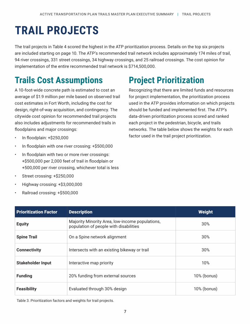
TRAIL PROJECTSThe trail projects in Table 4 scored the highest in the ATP prioritization process. Details on the top six projects are included starting on page 10. The ATP’s recommended trail network includes approximately 174 miles of trail, 94 river crossings, 331 street crossings, 34 highway crossings, and 25 railroad crossings. The cost opinion for implementation of the entire recommended trail network is $714,500,000.
Trails Cost AssumptionsA 10-foot-wide concrete path is estimated to cost an average of $1.9 million per mile based on observed trail cost estimates in Fort Worth, including the cost for design, right-of-way acquisition, and contingency. The citywide cost opinion for recommended trail projects also includes adjustments for recommended trails in floodplains and major crossings:
• In floodplain: +$250,000
• In floodplain with one river crossing: +$500,000
• In floodplain with two or more river crossings: +$500,000 per 2,000 feet of trail in floodplain or +500,000 per river crossing, whichever total is less
• Street crossing: +$250,000
• Highway crossing: +$3,000,000
• Railroad crossing: +$500,000
Project PrioritizationRecognizing that there are limited funds and resources for project implementation, the prioritization process used in the ATP provides information on which projects should be funded and implemented first. The ATP’s data-driven prioritization process scored and ranked each project in the pedestrian, bicycle, and trails networks. The table below shows the weights for each factor used in the trail project prioritization.
Prioritization Factor Description Weight
Equity Majority Minority Area, low-income populations,population of people with disabilities 30%
Spine Trail On a Spine network alignment 30%
Connectivity Intersects with an existing bikeway or trail 30%
Stakeholder Input Interactive map priority 10%
Funding 20% funding from external sources 10% (bonus)
Feasibility Evaluated through 30% design 10% (bonus)
Table 3. Prioritization factors and weights for trail projects.

8
ACTIVE TRANSPORTATION PLAN TRAILS MASTER PLAN EXECUTIVE SUMMARY | TRAIL NETWORK DEVELOPMENT APPROACH
Figure 6. Top 20 trail projects

9
ACTIVE TRANSPORTATION PLAN TRAILS MASTER PLAN EXECUTIVE SUMMARY | TRAIL NETWORK DEVELOPMENT APPROACH
Table 4. Top 20 priority trail projects and cost opinions.
Priority Rank Trail Name From To Length
(feet)Cost
Opinion
1 TEXRail Trail Segments
Trinity River (near Trail Drivers Park)
TEXRail Mercantile Center Station 14,054 $14,000,000
2 Marine Creek Trail 23rd St Trinity River Trail 2,547 $2,200,000
3 Bomber Spur Trail (South Extension) Calmont Ave Vickery Blvd 12,916 $21,100,000
4 Sycamore Creek Trail I-30 Sycamore Park 6,118 $14,200,000
5 Marine Creek Trail Cromwell Marine Creek Marine Creek Lake Trail 4,399 $2,700,000
6Krauss Baker Park/Woodmont Park Trail Connection
Krauss Baker Park (McCart Ave)
Woodmont Park (Woodmont Trl) 1,974 $1,900,000
7 Western Hills Oncor Trail North Dale Ln Calmont Ave (at SH
183) 11,466 $7,100,000
8 Trinity Trail (North Bank)
Trinity River (near Trail Drivers Park)
Riverside Park (near Embrey Pl) 8,217 $9,300,000
9 Western Hills Oncor Trail South
Calmont Ave (at Glenrock Dr) Chapin Rd 7,265 $11,300,000
10 Sycamore Creek Trail Cobb Park (Old Mansfield Rd)
Carter Park (Seminary Dr) 11,982 $11,800,000
11 Big Bear Creek Trail Existing Trail (near Golden Triangle Blvd and Goldrush Dr)
Fort Worth/Keller City Limits 10,743 $5,700,000
12 Bomber Spur Trail (North Extension)
Sherry Ln (Fort Worth/Westworth Village City Limits) Calmont Ave 8,512 $12,800,000
13 Trinity Trail (North Bank) University Dr SH 199 2,999 $7,100,000
14 Wedgwood Trail Granbury Rd Woodway Dr 10,043 $8,900,000
15 Fossil Creek Trail TX-121 (Fort Worth/Richland Hills City Limits) Existing Trinity Trail 5,640 $3,600,000
16 Sycamore Creek Trail Seminary Dr Fair Park Blvd 5,262 $2,700,000
17 Altamesa Rail Trail Campus Dr Wichita St 7,154 $4,800,000
18 Sycamore Creek Trail Fair Park Blvd Altamesa Blvd 13,862 $21,800,000
19 Crawford Farms Park Trail Connection Wexford Dr (Existing Trail) Sinclair Park Trail
(Existing Trail) 805 $1,100,000
20 Lake Arlington Trail Rosedale St Berry St 10,436 $4,100,000

Æb
Æb
Little F ossil Creek
West ForkTrinity River
Mar ine Creek
RodeoPark
TrailDriversPark
HistoricMarine
28TH
MAIN
NORTHSIDE
LONG
BEAC
H
SYLV
ANIA
DEEN
RIVERSIDE
BLUE
MOU
ND
TERMINAL
GEMINI
NMA
INTE
RMINA
L
TEXR
AIL
Saginaw
Haltom City
£¤377
§̈¦35W
")183")287B
Priority Trail ProjectProposed Facilities
Bicycle FacilitySidepathTrail
Existing and Funded FacilitiesTrailSidepathBicycle FacilityNatural Surface Trail
Urban VillagesCity of Fort WorthOther Cities
Æb TexRail Stations
Public ParkWaterRiverRail
E0 1,000 2,000 Feet
West Fork Trinity RiverMarine Creek
Saunders Park
TrailDriversPark
HistoricMarine
MAIN
")287B
Priority Trail ProjectProposed Facilities
Bicycle FacilitySidepathTrail
Existing and Funded FacilitiesTrailSidepathBicycle FacilityNatural Surface Trail
Urban VillagesCity of Fort WorthOther Cities
Æb TexRail Stations
Public ParkWaterRiverRail
E0 250 500 Feet
Floodplain/ Estimated Stream Crossing(s)
10
ACTIVE TRANSPORTATION PLAN TRAILS MASTER PLAN EXECUTIVE SUMMARY | TRAIL PROJECT CUT SHEETSTRAIL PROJECT CUT SHEETSFort Worth Active Transportation Plan Priority Trail Project#1: TEXRail Trail Connection
General Description
Additional Project Considerations
Project Characteristics
This trail would provide a shared-use trail connection between the existing Trinity River Trail near Trail Drivers Park to two TEXRail stations (North Side Station and Mercantile Center Station) via the TEXRail rail corridor and Long Avenue. It would connect to existing trail segments in Trail Drivers Park. On-street bicycle facilities along Decatur Ave and Long Ave would be necessary to create a continuous route. This project requires interagency coordination (TxDOT, rail).
Trail Name/Location TEXRail Trail
Project LimitsFrom Trinity River Trail
(near Trail Drivers Park)To TEXRail Mercantile Center Station
Length (mi) 2.7 (trail segments only)
Facility Type Trail
Proposed Veloweb Yes
Project Status Proposed Alignment
Estimated Project Cost $14,000,000*
Funding Source TBD
Major Destinations
• Trinity Trails• Trail Drivers Park• North Side Station• Mercantile Center Station• City of Haltom City (future
trail connection)
*Estimate does not include cost for on-street facility connections
1
1
2
✓
✓
Major Thoroughfare/Highway Crossing(s)
Rail Crossing(s)Interjurisdictional Connection
Connects to Existing Trail System

West Fork Trinity RiverMarine Creek
Saunders Park
TrailDriversPark
HistoricMarine
MAIN
")287B
Priority Trail ProjectProposed Facilities
Bicycle FacilitySidepathTrail
Existing and Funded FacilitiesTrailSidepathBicycle FacilityNatural Surface Trail
Urban VillagesCity of Fort WorthOther Cities
Æb TexRail Stations
Public ParkWaterRiverRail
E0 250 500 Feet
Floodplain/ Estimated Stream Crossing(s)
11
ACTIVE TRANSPORTATION PLAN TRAILS MASTER PLAN EXECUTIVE SUMMARY | TRAIL PROJECT CUT SHEETSFort Worth Active Transportation Plan Priority Trail Project#2: Marine Creek Trail Connection
General Description
Additional Project Considerations
Project Characteristics
This trail would complete a shared-use trail connection between the southern end of the existing trail through Saunders Park in the Stockyards District and the Trinity Trails. This connection would primarily follow the Marine Creek waterway. This project requires interagency coordination (rail).
Trail Name/Location Marine Creek Trail Connection
Project LimitsFrom 23rd Street
(near the Stockyards)To Trinity Trails
Length (mi) 0.5
Facility Type Trail
Proposed Veloweb Yes
Project Status Proposed Alignment
Estimated Project Cost $2,200,000
Funding Source TBD
Major Destinations • Fort Worth Stockyards• Trinity Trails1
2
✓
Major Thoroughfare/Highway Crossing(s)Rail Crossing(s)
Interjurisdictional Connection
Connects to Existing Trail System

Clear Fork Trinity River
M arys Creek
North Z BoazCommunity
ParkRidglea
ARBORLAWN
SOUTHWEST
CAMP BOWIE
BENB
ROOK
BRYA
NT IR
VIN
VICKERY
RIVER PARK
GREE
NOA
KSCALMONT
LAS
VEGA
S
RIVERBEND
LACKLAND
CHER
RY
CAMP BOWIE WEST
ALTA
MER
E
Benbrook
£¤377
")121
§̈¦30
§̈¦820
")580
")183
Priority Trail ProjectProposed Facilities
Bicycle FacilitySidepathTrail
Existing and Funded FacilitiesTrailSidepathBicycle FacilityNatural Surface Trail
Urban VillagesCity of Fort WorthOther Cities
Æb TexRail Stations
Public ParkWaterRiverRail
E0 1,000 2,000 Feet
West F ork Trinity River
Sycamore Creek
Glenwood Park
SycamoreCreek Golf
Course
Sycamore Park
Gateway Park
Near EastSide
Polytechnic/Wesleyan
RIVERSIDE
BEAC
H
VICKERY
LANCASTER
NASHVILLE
£¤287£¤287B
§̈¦30
")180
Priority Trail ProjectProposed Facilities
Bicycle FacilitySidepathTrail
Existing and Funded FacilitiesTrailSidepathBicycle FacilityNatural Surface Trail
Urban VillagesCity of Fort WorthOther Cities
Æb TexRail Stations
Public ParkWaterRiverRail
E0 500 1,000 Feet
12
ACTIVE TRANSPORTATION PLAN TRAILS MASTER PLAN EXECUTIVE SUMMARY | TRAIL PROJECT CUT SHEETSFort Worth Active Transportation Plan Priority Trail Project#3: Bomber Spur Trail
General Description
Additional Project Considerations
Project Characteristics
This trail would complete the southern extension of the Bomber Spur Trail from the Ridgmar Mall area near I-30 to Vickery Boulevard and the City of Benbrook. This project would connect to the existing Trinity River trails via a planned on-street bicycle facility on Vickery Boulevard. This alignment primarily utilizes the former Bomber Spur rail corridor. This project requires interagency coordination (TxDOT).
Trail Name/Location Bomber Spur Trail
Project LimitsFrom Calmont Ave
To Vickery Blvd
Length (mi) 2.4
Facility Type Trail
Proposed Veloweb Yes
Project Status Proposed Alignment
Estimated Project Cost $21,100,000
Funding Source TBD
Major Destinations• Ridgmar Mall area• North Z Boaz Community Park• City of Benbrook
3
✓
Major Thoroughfare/Highway Crossing(s)
Rail Crossing(s)Interjurisdictional Connection
Connects to Existing Trail System
Floodplain/ Estimated Stream Crossing(s)

West F ork Trinity River
Sycamore Creek
Glenwood Park
SycamoreCreek Golf
Course
Sycamore Park
Gateway Park
Near EastSide
Polytechnic/Wesleyan
RIVERSIDE
BEAC
H
VICKERY
LANCASTER
NASHVILLE
£¤287£¤287B
§̈¦30
")180
Priority Trail ProjectProposed Facilities
Bicycle FacilitySidepathTrail
Existing and Funded FacilitiesTrailSidepathBicycle FacilityNatural Surface Trail
Urban VillagesCity of Fort WorthOther Cities
Æb TexRail Stations
Public ParkWaterRiverRail
E0 500 1,000 Feet
*Estimate does not include cost for on-street facility connections13
ACTIVE TRANSPORTATION PLAN TRAILS MASTER PLAN EXECUTIVE SUMMARY | TRAIL PROJECT CUT SHEETSFort Worth Active Transportation Plan Priority Trail Project#4: Sycamore Creek Trail
General Description
Additional Project Considerations
Project Characteristics
This trail would provide a shared-use trail connection between the existing Trinity River Trail north of I-30 (near Beach Street) and the existing trail in Sycamore Park. This project requires interagency coordination (TxDOT, rail).
Trail Name/Location Sycamore Creek Trail
Project LimitsFrom Trinity River Trail
To Sycamore Park
Length (mi) 1.2
Facility Type Trail
Proposed Veloweb Yes
Project Status Proposed Alignment
Estimated Project Cost $14,200,000*
Funding Source TBD
Major Destinations • Trinity Trails• Sycamore Park
2
2
1
✓
Floodplain/ Estimated Stream Crossing(s)
Major Thoroughfare/Highway Crossing(s)Rail Crossing(s)
Interjurisdictional Connection
Connects to Existing Trail System

Fort Worth Active Transportation Plan Priority Trail Project#5: Marine Creek Trail
Mar
ineCr
eek
AndersonPark
Marine CreekRanch Park
CROMWELL MARINE CREEK
LONGHORN
MARINE CREEK
HUFF
INES
OLD DECATUR
TEN MILE BRIDGE
Saginaw
Priority Trail ProjectProposed Facilities
Bicycle FacilitySidepathTrail
Existing and Funded FacilitiesTrailSidepathBicycle FacilityNatural Surface Trail
Urban VillagesCity of Fort WorthOther Cities
Æb TexRail Stations
Public ParkWaterRiverRail
E0 1,000 2,000 Feet
Fort Worth Active Transportation Plan Priority Trail Project#5: Marine Creek Trail
General Description
Additional Project Considerations
Project Characteristics
This trail would provide a shared-use trail connection from the existing Marine Creek Lake Trail and the Tarrant County College - Northwest Campus Area north to Cromwell Marine Creek Road. This trail extension would add connectivity near the Northwest Branch Library, as well as a number of local schools and existing neighborhoods.
Trail Name/Location Marine Creek Trail
Project LimitsFrom Cromwell Marine Creek Road
To Marine Creek Lake Trail
Length (mi) 0.8
Facility Type Trail
Proposed Veloweb Yes
Project Status Proposed Alignment
Estimated Project Cost $2,700,000
Funding Source TBD
Major Destinations
• Northwest Branch Library• Marine Creek Lake• Tarrant County College -
Northwest Campus Area
DRAFT
✓ ✓
✓
Major Thoroughfare/Highway Crossing(s)
Floodplain/Stream Crossing(s)
Rail Crossing(s)
Interjurisdictional Connection
Connects to Existing Trail System
KraussBaker Park
Woodmont Park
WestcreekPark
Southcreek Park
ALTAMESA
MC CART
EdgecliffVillage
Priority Trail ProjectProposed Facilities
Bicycle FacilitySidepathTrail
Existing and Funded FacilitiesTrailSidepathBicycle FacilityNatural Surface Trail
Urban VillagesCity of Fort WorthOther Cities
Æb TexRail Stations
Public ParkWaterRiverRail
E0 300 600 Feet
14
General Description
Additional Project Considerations
Project Characteristics
This trail would provide a shared-use trail connection from the existing Marine Creek Lake Trail and the Tarrant County College - Northwest Campus Area north to Cromwell Marine Creek Road. This trail extension would add connectivity near the Northwest Branch Library, as well as a number of local schools and existing neighborhoods.
Trail Name/Location Marine Creek Trail
Project LimitsFrom Cromwell Marine Creek Road
To Marine Creek Lake Trail
Length (mi) 0.8
Facility Type Trail
Proposed Veloweb Yes
Project Status Proposed Alignment
Estimated Project Cost $2,700,000
Funding Source TBD
Major Destinations
• Northwest Branch Library• Marine Creek Lake• Tarrant County College - Northwest
Campus Area
1 1
✓
Floodplain/ Estimated Stream Crossing(s)
Major Thoroughfare/Highway Crossing(s)
Rail Crossing(s)Interjurisdictional Connection
Connects to Existing Trail System

KraussBaker Park
Woodmont Park
WestcreekPark
Southcreek Park
ALTAMESA
MC CART
EdgecliffVillage
Priority Trail ProjectProposed Facilities
Bicycle FacilitySidepathTrail
Existing and Funded FacilitiesTrailSidepathBicycle FacilityNatural Surface Trail
Urban VillagesCity of Fort WorthOther Cities
Æb TexRail Stations
Public ParkWaterRiverRail
E0 300 600 Feet
15
ACTIVE TRANSPORTATION PLAN TRAILS MASTER PLAN EXECUTIVE SUMMARY | TRAIL PROJECT CUT SHEETSFort Worth Active Transportation Plan Priority Trail Project#6: Krauss Baker Park/Woodmont Park Trail Connection
General Description
Additional Project Considerations
Project Characteristics
This trail would provide a shared-use trail connection between the existing trail in Krauss Baker Park to the existing trail in Woodmont Park.
Trail Name/Location Krauss Baker Park/Woodmont Park Trail Connection
Project LimitsFrom Krauss Baker Park
(near McCart Ave)
To Woodmont Park (near Woodmont Trl)
Length (mi) 0.4
Facility Type Trail
Proposed Veloweb Yes
Project Status Proposed Alignment
Estimated Project Cost $1,900,000
Funding Source TBD
Major Destinations • Krauss Baker Park• Woodmont Park
✓
✓
Floodplain (no estimated stream crossings)
Major Thoroughfare/Highway Crossing(s)Rail Crossing(s)
Interjurisdictional Connection
Connects to Existing Trail System
2

16
ACTIVE TRANSPORTATION PLAN TRAILS MASTER PLAN EXECUTIVE SUMMARY | TRAIL DESIGN TOOLBOX
TRAIL DESIGN TOOLBOXIntroductionThe Trail Design Toolbox describes the design criteria that the Fort Worth Active Transportation Plan recommends for trails that run in an independent right-of-way. This toolbox is divided into three sections:
1. Trail Network Classifications
A. Spines
A. Ribs
A. Local Trails
2. Trail Amenity Accommodation Checklist
3. Trail Design Best Practices
A. Trailheads
A. Creating Trail Identity
A. Lighting
A. Signage & Wayfinding
A. Intersections & Crossings
To guide the future development of trails in Fort Worth, a range of design standards have been developed to accommodate different conditions based on the current or anticipated level of activity and user type. Providing a range takes into account the many constraints and particularities of varying trail settings. This flexible approach to trail design aims to maintain superior standards and ensures that all users can feel comfortable using active transportation facilities all over the City of Fort Worth.
Figure 7. Trail system map sign. (Photo: City of Fort Worth)
Figure 8. Share the trail signs. (Photo credit: Kimley-Horn and Associates)
Figure 9. Map under bridge along the Clearfork Branch of Trinity Trails. (Photo credit: Kimley-Horn and Associates)

17
ACTIVE TRANSPORTATION PLAN TRAILS MASTER PLAN EXECUTIVE SUMMARY | TRAIL DESIGN TOOLBOX
Trail ClassificationsTrail classifications bring a context-sensitive approach that uses the anticipated function to inform how the trail should be designed. The trail network was designed by classifying all trails into three categories:
• Spines
• Ribs
• Local Trails
Trails classified as Spines act as the primary backbone for the network and largely incorporate the Regional Veloweb network. They emphasize long-distance connectivity and create major cross-town connections.
Branching off of the spine trails are the Ribs. The primary purpose of these trails is to connect spine trails to neighborhoods and make non-regional connections.
Local Trails are the final network level and make the last-mile connections to destinations and neighborhoods.
Figure 10. Welcome sign at River Park. (Photo credit: Kimley-Horn and Associates)
Figure 12. Wall mural along the Clearfork Branch of Trinity Trails. (Photo credit: Kimley-Horn and Associates)
Figure 11. Decorative statue along the Clearfork Branch of Trinity Trails. (Photo credit: Kimley-Horn and Associates)
18
ACTIVE TRANSPORTATION PLAN TRAILS MASTER PLAN EXECUTIVE SUMMARY | TRAIL DESIGN TOOLBOX
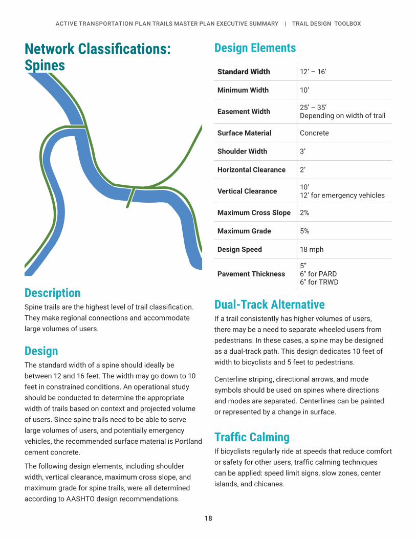
Network Classifications: Spines
DescriptionSpine trails are the highest level of trail classification. They make regional connections and accommodate large volumes of users.
DesignThe standard width of a spine should ideally be between 12 and 16 feet. The width may go down to 10 feet in constrained conditions. An operational study should be conducted to determine the appropriate width of trails based on context and projected volume of users. Since spine trails need to be able to serve large volumes of users, and potentially emergency vehicles, the recommended surface material is Portland cement concrete.
The following design elements, including shoulder width, vertical clearance, maximum cross slope, and maximum grade for spine trails, were all determined according to AASHTO design recommendations.
Design Elements
Standard Width 12’ – 16’
Minimum Width 10’
Easement Width 25’ – 35’Depending on width of trail
Surface Material Concrete
Shoulder Width 3’
Horizontal Clearance 2’
Vertical Clearance 10’12’ for emergency vehicles
Maximum Cross Slope 2%
Maximum Grade 5%
Design Speed 18 mph
Pavement Thickness5”6” for PARD6” for TRWD
Dual-Track AlternativeIf a trail consistently has higher volumes of users, there may be a need to separate wheeled users from pedestrians. In these cases, a spine may be designed as a dual-track path. This design dedicates 10 feet of width to bicyclists and 5 feet to pedestrians.
Centerline striping, directional arrows, and mode symbols should be used on spines where directions and modes are separated. Centerlines can be painted or represented by a change in surface.
Traffic CalmingIf bicyclists regularly ride at speeds that reduce comfort or safety for other users, traffic calming techniques can be applied: speed limit signs, slow zones, center islands, and chicanes.

19
ACTIVE TRANSPORTATION PLAN TRAILS MASTER PLAN EXECUTIVE SUMMARY | TRAIL DESIGN TOOLBOX
Network Classifications: Ribs
DescriptionTrails classified as ribs provide important connections, dispersing spine traffic out to their final destinations.
DesignThe standard width of a rib trail is 12 feet with 10 feet as a minimum. The surface material of rib trails can be either concrete or asphalt, depending on the local context.
The following design elements, including shoulder width, vertical clearance, maximum cross slope, and maximum grade for rib trails, were all determined according to AASHTO design recommendations.
Design Elements
Standard Width 10’ – 12’
Minimum Width 10’
Easement Width 25’
Surface Material Concrete or Asphalt
Shoulder Width 2’
Vertical Clearance 10’
Maximum Cross Slope 2%
Maximum Grade 5%8.33% for segments <200’
Design Speed 18 mph
20
ACTIVE TRANSPORTATION PLAN TRAILS MASTER PLAN EXECUTIVE SUMMARY | TRAIL DESIGN TOOLBOX
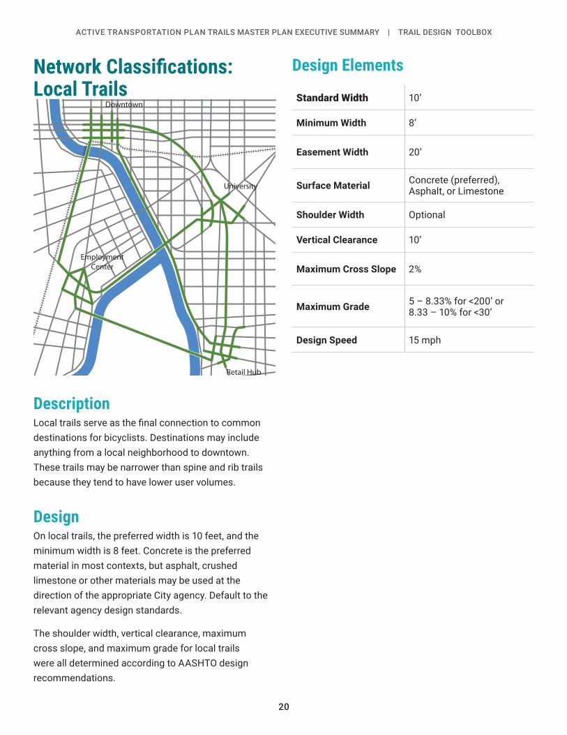
Network Classifications: Local Trails
DescriptionLocal trails serve as the final connection to common destinations for bicyclists. Destinations may include anything from a local neighborhood to downtown. These trails may be narrower than spine and rib trails because they tend to have lower user volumes.
DesignOn local trails, the preferred width is 10 feet, and the minimum width is 8 feet. Concrete is the preferred material in most contexts, but asphalt, crushed limestone or other materials may be used at the direction of the appropriate City agency. Default to the relevant agency design standards.
The shoulder width, vertical clearance, maximum cross slope, and maximum grade for local trails were all determined according to AASHTO design recommendations.
Design Elements
Standard Width 10’
Minimum Width 8’
Easement Width 20’
Surface Material Concrete (preferred), Asphalt, or Limestone
Shoulder Width Optional
Vertical Clearance 10’
Maximum Cross Slope 2%
Maximum Grade 5 – 8.33% for <200’ or8.33 – 10% for <30’
Design Speed 15 mph
Downtown
University
Employment Center
Retail Hub
21
ACTIVE TRANSPORTATION PLAN TRAILS MASTER PLAN EXECUTIVE SUMMARY | TRAIL DESIGN TOOLBOX
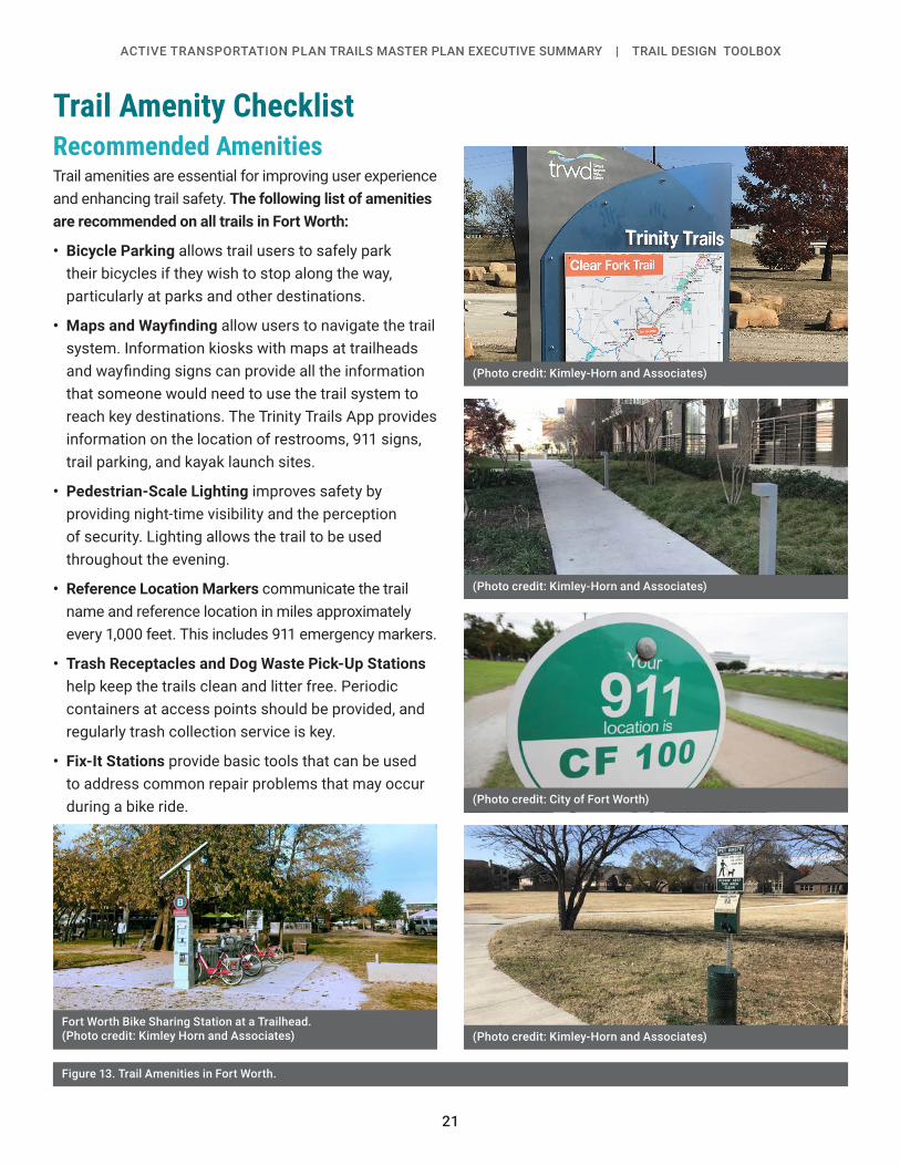
Trail Amenity ChecklistRecommended AmenitiesTrail amenities are essential for improving user experience and enhancing trail safety. The following list of amenities are recommended on all trails in Fort Worth:
• Bicycle Parking allows trail users to safely park their bicycles if they wish to stop along the way, particularly at parks and other destinations.
• Maps and Wayfinding allow users to navigate the trail system. Information kiosks with maps at trailheads and wayfinding signs can provide all the information that someone would need to use the trail system to reach key destinations. The Trinity Trails App provides information on the location of restrooms, 911 signs, trail parking, and kayak launch sites.
• Pedestrian-Scale Lighting improves safety by providing night-time visibility and the perception of security. Lighting allows the trail to be used throughout the evening.
• Reference Location Markers communicate the trail name and reference location in miles approximately every 1,000 feet. This includes 911 emergency markers.
• Trash Receptacles and Dog Waste Pick-Up Stations help keep the trails clean and litter free. Periodic containers at access points should be provided, and regularly trash collection service is key.
• Fix-It Stations provide basic tools that can be used to address common repair problems that may occur during a bike ride.
Figure 13. Trail Amenities in Fort Worth.
(Photo credit: Kimley-Horn and Associates)
(Photo credit: Kimley-Horn and Associates)
(Photo credit: Kimley-Horn and Associates)
(Photo credit: City of Fort Worth)
Fort Worth Bike Sharing Station at a Trailhead. (Photo credit: Kimley Horn and Associates)
22
ACTIVE TRANSPORTATION PLAN TRAILS MASTER PLAN EXECUTIVE SUMMARY | TRAIL DESIGN TOOLBOX
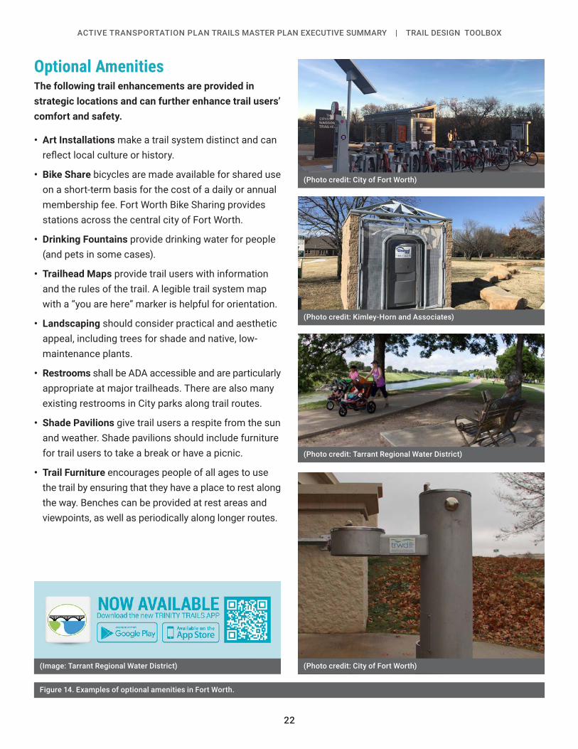
Optional AmenitiesThe following trail enhancements are provided in strategic locations and can further enhance trail users’ comfort and safety.
• Art Installations make a trail system distinct and can reflect local culture or history.
• Bike Share bicycles are made available for shared use on a short-term basis for the cost of a daily or annual membership fee. Fort Worth Bike Sharing provides stations across the central city of Fort Worth.
• Drinking Fountains provide drinking water for people (and pets in some cases).
• Trailhead Maps provide trail users with information and the rules of the trail. A legible trail system map with a “you are here” marker is helpful for orientation.
• Landscaping should consider practical and aesthetic appeal, including trees for shade and native, low-maintenance plants.
• Restrooms shall be ADA accessible and are particularly appropriate at major trailheads. There are also many existing restrooms in City parks along trail routes.
• Shade Pavilions give trail users a respite from the sun and weather. Shade pavilions should include furniture for trail users to take a break or have a picnic.
• Trail Furniture encourages people of all ages to use the trail by ensuring that they have a place to rest along the way. Benches can be provided at rest areas and viewpoints, as well as periodically along longer routes.
Figure 14. Examples of optional amenities in Fort Worth.
(Photo credit: Kimley-Horn and Associates)
(Photo credit: Tarrant Regional Water District)
(Photo credit: City of Fort Worth)
(Photo credit: City of Fort Worth)(Image: Tarrant Regional Water District)
23
ACTIVE TRANSPORTATION PLAN TRAILS MASTER PLAN EXECUTIVE SUMMARY | TRAIL DESIGN TOOLBOX
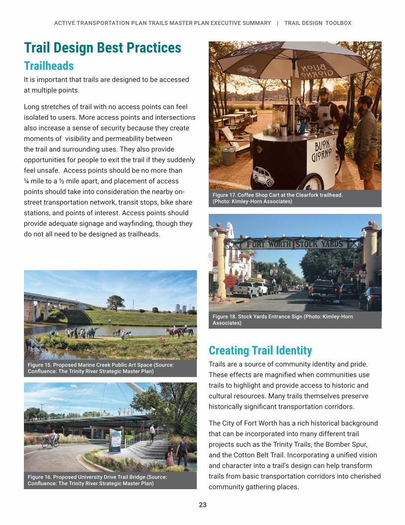
Trail Design Best PracticesTrailheadsIt is important that trails are designed to be accessed at multiple points.
Long stretches of trail with no access points can feel isolated to users. More access points and intersections also increase a sense of security because they create moments of visibility and permeability between the trail and surrounding uses. They also provide opportunities for people to exit the trail if they suddenly feel unsafe. Access points should be no more than ¼ mile to a ½ mile apart, and placement of access points should take into consideration the nearby on-street transportation network, transit stops, bike share stations, and points of interest. Access points should provide adequate signage and wayfinding, though they do not all need to be designed as trailheads.
Figure 17. Coffee Shop Cart at the Clearfork trailhead. (Photo: Kimley-Horn Associates)
Figure 18. Stock Yards Entrance Sign (Photo: Kimley-Horn Associates)
Figure 15. Proposed Marine Creek Public Art Space (Source: Confluence: The Trinity River Strategic Master Plan)
Figure 16. Proposed University Drive Trail Bridge (Source: Confluence: The Trinity River Strategic Master Plan)
Creating Trail IdentityTrails are a source of community identity and pride. These effects are magnified when communities use trails to highlight and provide access to historic and cultural resources. Many trails themselves preserve historically significant transportation corridors.
The City of Fort Worth has a rich historical background that can be incorporated into many different trail projects such as the Trinity Trails, the Bomber Spur, and the Cotton Belt Trail. Incorporating a unified vision and character into a trail’s design can help transform trails from basic transportation corridors into cherished community gathering places.

24
ACTIVE TRANSPORTATION PLAN TRAILS MASTER PLAN EXECUTIVE SUMMARY | TRAIL DESIGN TOOLBOX
Lighting PlacementTrail lighting is recommended at the following locations:
• Under vehicular bridges, underpasses, tunnels, or locations with limited visibility
• Along bridges used by bicycles and pedestrians
• Along routes or trail segments where frequent evening or nighttime use is anticipated
• On routes that are within ¼ mile from Trinity Metro transit stations, near schools and major employers
• Along high-use portions of trails that lead to areas with frequent evening events
• At trail intersections with roadways or driveways where crossing is required
• At major trail entrances/trailheads
Other FactorsOther factors to consider when planning lighting elements for a trail include:
• Limit lighting in natural and undeveloped areas to mitigate environmental disturbance, or use light fixtures designed to minimize negative impacts
• Consider timed lighting for commuting (e.g. evening and early dawn)
• Consider other needs of users related to nighttime and evening use (e.g., security measures)
• Include signage or information for trail users to notify the City if a light is out or damaged
• Artificial nighttime lighting should be turned off after curfew along riparian corridors and other less-developed areas.
• Trail lighting is not permitted on Oncor easement alignments
Figure 19. Sidepath Lighting in Burlington, VT. (Photo: Toole Design)
Figure 20. Pedestrian-Scale Lighting at Park (Photo credit: ferobanjo, pixabay license)

25
ACTIVE TRANSPORTATION PLAN TRAILS MASTER PLAN EXECUTIVE SUMMARY | TRAIL DESIGN TOOLBOX
Signage and WayfindingAppropriate and helpful signage is essential to making users comfortable along extensive trail systems. The elements of a well-designed signage system include:
• Uniformity and Design
• Legibility
• Placement
• Safety
• Communication
• Awareness
Design Factors
Uniformity and DesignCity staff and stakeholders should work together to create a streamlined design for wayfinding signs that allows trail users to easily identify, understand, and navigate the network.
LegibilityThe shape, size, text, and icons on a sign should be legible for users of all ages and for both locals and visitors. They should also be easy to understand for English and non-English speakers, as well as visually impaired people. For important messages conveyed by text, consider including a Spanish translation.
PlacementSigns should be placed at entrances, intersections, and at forks in the trails to inform and guide trail users. Such signage aims to inform users of all directional options, nearby destinations, and attractions.
CommunicationSignage should convey distance, direction, and destination. Trail etiquette signage conveys appropriate speed and “keep right, pass left” messages.
AwarenessIn order for more people to use the trails, they need to know that they exist, where they are located, and how to access them. Better wayfinding and signage can attract more users.
Figure 21. Example of Wayfinding Sign in Fort Worth. (Photo Credit: City of Fort Worth)

26
ACTIVE TRANSPORTATION PLAN TRAILS MASTER PLAN EXECUTIVE SUMMARY | TRAIL DESIGN TOOLBOX
Intersections and CrossingsIt is important to properly design crossings to provide the safest situation for all users. Poorly designed or regulated crossings can lead to people disregarding traffic control measures, which reduces safety for everyone. The sign types, pavement markings, and crossing types will depend on the local conditions at each crossing.
Mid-Block Roadway CrossingsMid-block trail crossings should be properly signed and marked. The crossing should be perpendicular to the street to minimize the crossing length. The approaching path can also have a horizontal curve in advance of the crossing to help slow down trail users as they approach. Mid-block crossings are not recommended on roadways with posted speeds of 40 MPH or greater unless a signal is installed.
Trail Bridges and Underpasses (Grade-Separated Crossings)Bridges and underpasses are permitted when grade separation is needed for crossing a roadway or railroad, or when the natural topography cannot accommodate trail requirements such as streams or hills.
Bridges should be at least 1-2 feet wider than the trail on each side to allow users to stop without obstructing the trail and to provide a clearance for bicyclists from the adjacent railings.
When designing a trail to accommodate bicycles across a high bridge, such as a bridge that goes over a body of water or major roadway, railing should be provided. AASHTO recommends a railing height of 42” – 48” depending on the site location. The railing design should also consider sight lines of pedestrians and bicyclists. Bridge approaches and span should not exceed 5% slope ADA access. Underpasses should be built to allow a vertical clearance of at least 10 feet.
Refer to the 2019 Fort Worth Traffic Engineering Manual (TEM) for further guidance on bicycle facility design on bridges.
Multi-Use TrailUsers should be given adequate advance notice of intersections between two trails. Advanced warning signs, such as the MUTCD Intersection Warning signs (See Figure 15) or directional signs should be placed near the intersection. Advanced warning signs should be placed a minimum of 50 feet from the crossing and directional signs could be placed on the corners. The crossing paths should try to be aligned at a 90-degree angle when possible. The line of sight as the two trails converge should be kept clear of obstructions. Roundabout style intersections are also permitted as an alternative.
Figure 22. MUTCD signs W2-1, 2, 3, 4, and 5

27
THIS PAGE IS INTENTIONALLY LEFT BLANK.

Fort Worth Active Transportation PlanTRAIL EXECUTIVE SUMMARY
April 2019


