Case Study COLORADO US-285: FOXTON ROAD TO BAILEY Using a Context Sensitive Solutions Approach to Highway Capacity Accelerating solutions for highway safety, renewal, reliability, and capacity
Transcript
$
Case Study
COLORADO US-285:FOXTON ROAD TO BAILEY
Using a Context Sensitive Solutions Approach to
Highway Capacity
Accelerating solutions for highway safety, renewal, reliability, and capacity
This case study was developed through SHRP 2 Capacity Project C01: A Framework for Collaborative Decision Making on Additions to Highway Capacity. It is integrated into Transportation for Communities: Advancing Proj-ects through Partnerships, a website that is a product of research conducted under Capacity Project C01 (www.transportationforcommunities.com).
The Transportation for Communities website provides a systematic approach for reaching collaborative decisions about adding highway capacity that enhance the environment, the economy, and the community and improve trans-portation. It identifies key decision points in four phases of transportation decision making: long-range transporta-tion planning, corridor planning, programming, and environmental review and permitting.
The case studies for Capacity Project C01 were prepared by ICF International, Research Triangle Park, North Caro-lina; URS Corporation, Morrisville, North Carolina; and Marie Venner Consulting, Lakewood, Colorado.
This work was sponsored by the Federal Highway Administration in cooperation with the American Association of State Highway and Transportation Officials. It was conducted in the second Strategic Highway Research Program (SHRP 2), which is administered by the Transportation Research Board of the National Academies.
Copyright information
Authors herein are responsible for the authenticity of their materials and for obtaining written permissions from publishers or persons who own the copyright to any previously published or copyrighted material used herein.
The second Strategic Highway Research Program grants permission to reproduce material in this publication for classroom and not-for-profit purposes. Permission is given with the understanding that none of the material will be used to imply TRB, AASHTO, or FHWA endorsement of a particular product, method, or practice. It is expected that those reproducing material in this document for educational and not-for-profit purposes will give appropri-ate acknowledgment of the source of any reprinted or reproduced material. For other uses of the material, request permission from SHRP 2.
notiCe
Capacity Project C01 was a part of the second Strategic Highway Research Program, conducted by the Transporta-tion Research Board with the approval of the Governing Board of the National Research Council.
The members of the technical committee selected to monitor this project and to review this case study were chosen for their special competencies and with regard for appropriate balance. The case study was reviewed by the techni-cal committee and accepted for publication according to procedures established and overseen by the Transportation Research Board and approved by the Governing Board of the National Research Council.
The opinions and conclusions expressed or implied in this case study are those of the researchers who performed the research and are not necessarily those of the Transportation Research Board, the National Research Council, or the program sponsors.
The Transportation Research Board of the National Academies, the National Research Council, and the sponsors of the second Strategic Highway Research Program do not endorse products or manufacturers. Trade or manufacturers’ names appear herein solely because they are considered essential to the object of the case study.
Colorado US-285:Foxton road to Bailey
Using a Context Sensitive Solutions Approach to
Highway Capacity
Executive Summary 1Background 2Major Project Issues 4Institutional Framework for Decision Making 5Transportation Decision-Making Process and Key Decisions 6Lessons Learned 13Conclusion 17References 18
Case Study
Colorado US-285: Foxton road to Bailey
�
ExEcutivE SummaryThe US-285 project looked at expanding a 14.7-mi segment of mountainous highway southwest of Denver from two to four lanes. The project could have had major environmental issues, but an ex-perienced project team applying context sensitive solutions (CSS) carried out an efficient and quick process of planning and development that avoided major impacts to the environment, reduced the level of documentation required by the National Environmental Policy Act (NEPA), and saved time and money.
The US-285 project was a highly successful example of planning and development of additional highway capacity, a view shared by partners and stakeholders including the Colorado Department of Transportation, FHWA, the U.S. Environmental Protection Agency, the Sierra Club, and others. The project participants attribute the project’s success to the following:
• A flexible team of designers;• A proactive and knowledgeable environmental consultant;• Early collaboration with, and input from, agencies and interest groups;• Early identification of natural and cultural resources and community issues in a feasibility study;• Recognition of the benefits that could accrue from an efficient, collaborative process; and• Continuity of project team and contact with the public, nongovernmental organizations (NGOs),
and concerned agencies over the course of multiple studies and projects in the area.
The project-planning process combined project development, environmental review, and solu-tion screening into a single interactive and highly collaborative process. A corridor feasibility study led directly into a NEPA study of the segment from Foxton Road to Bailey. Because of the ability and willingness to avoid and mitigate impacts uncovered during the feasibility study, the NEPA documentation for the project was reduced from an environmental impact statement (EIS) to an environmental assessment (EA). Drawing from the lessons and groundwork of nearby highway projects, proactive outreach to community interest groups, and broad public support for widening the roadway, the US-285 project became an award-winning example of CSS and efficient planning and development (�, 2).
The success of the project was related to various project strategies and concepts captured in the theme of CSS. Primary among these was a serious engagement of the community, agencies, and other organizations into a collaborative decision-making process. The project held over 80 public meetings and workshops. These included a broad and inclusive value engineering process. From the beginning, there was a commitment to environmental stewardship. Mergers of multiple regulatory processes were enacted, and multiagency field trips resulted in consensus solutions and transparent decisions. In addition to these collaborative principles, the project gathered large-scale environmen-tal information early to support planning-level decision making. All these processes were aided by a flexible and positive attitude among the project teams.
Transportation needs were met to the full extent by increasing through-lane capacity from two lanes to four, providing access control, and improving substandard design elements. These safety and capacity improvements required a much larger footprint along US-285, but the designs were developed in a way that avoided impacts and had strong support from stakeholders. Measurable cost savings are estimated at over $59 million, and other benefits include exceptional public sup-port, environmental protection, reduction in accidents, and reductions in travel time.
Backgroundproject overviewHighway expansions are often contro-versial, especially in areas known for their scenic beauty, historic resources, and wildlife. The US-285 capacity improvement project examined how to expand a safety-challenged two-lane road into a four-lane highway, through a scenic area. The US-285 corridor is one of two routes to the mountains from the Denver metropol-itan area, the other being I-70. Before the advent of the Interstate system, the road was a more important thorough-fare between Colorado, New Mexico, and Texas, but since that time has become a scenic corridor eclipsed by other major interstates. The road is classified as a Regional Highway (R-A)/Non-Rural Principal Highway (NR-A), and the drive southwest from Denver into the Rocky Mountains is a beautiful open setting.
As a conduit for recreational traffic the road is prone to weekend bottlenecks. Slowing recreational vehicles on mountainous slopes and narrow roads of-fered no room for passing. In addition to recreational use, metro area residents have increasingly settled along US-285 from Foxton Road to Bailey, making it a “bedroom community” of residents who commute to Denver. The need for road widening focused on increasing capacity and safety, with an eye toward these major uses.
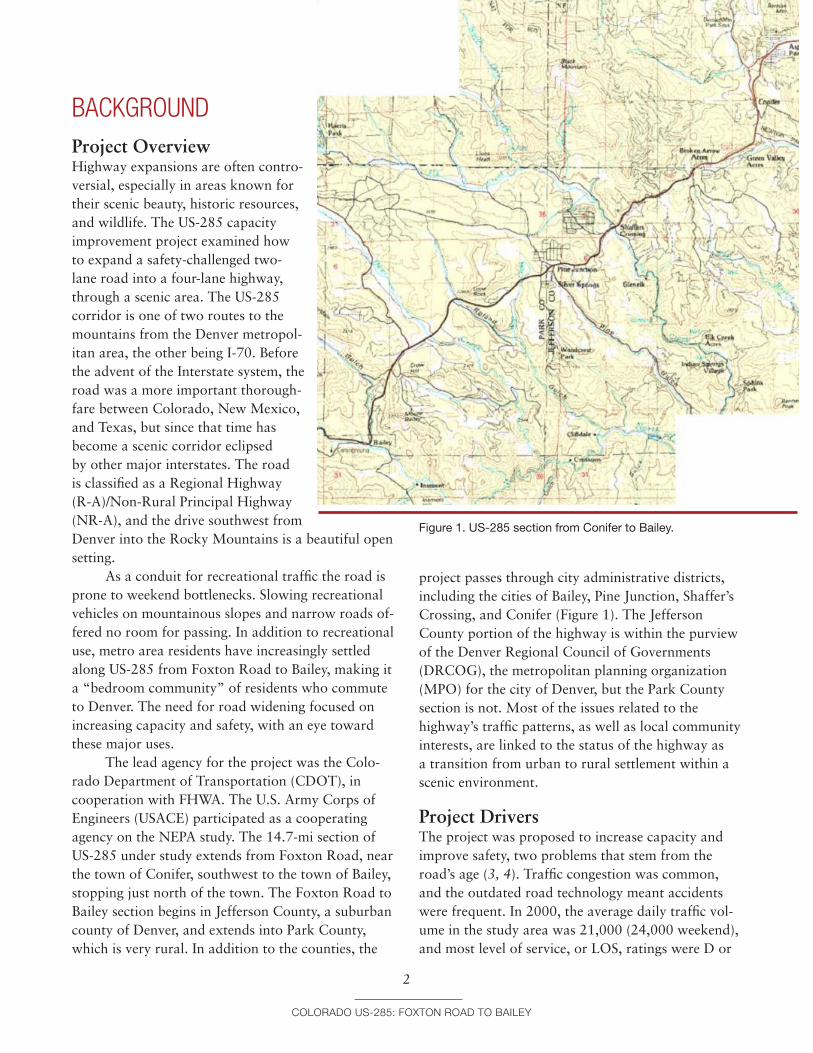
The lead agency for the project was the Colo-rado Department of Transportation (CDOT), in cooperation with FHWA. The U.S. Army Corps of Engineers (USACE) participated as a cooperating agency on the NEPA study. The 14.7-mi section of US-285 under study extends from Foxton Road, near the town of Conifer, southwest to the town of Bailey, stopping just north of the town. The Foxton Road to Bailey section begins in Jefferson County, a suburban county of Denver, and extends into Park County, which is very rural. In addition to the counties, the
Colorado US-285: Fo
2
project passes through city administrative districts, including the cities of Bailey, Pine Junction, Shaffer’s Crossing, and Conifer (Figure 1). The Jefferson County portion of the highway is within the purview of the Denver Regional Council of Governments (DRCOG), the metropolitan planning organization (MPO) for the city of Denver, but the Park County section is not. Most of the issues related to the highway’s traffic patterns, as well as local community interests, are linked to the status of the highway as a transition from urban to rural settlement within a scenic environment.
Figure 1. US-285 section from Conifer to Bailey.
project DriversThe project was proposed to increase capacity and improve safety, two problems that stem from the road’s age (3, 4). Traffic congestion was common, and the outdated road technology meant accidents were frequent. In 2000, the average daily traffic vol-ume in the study area was 21,000 (24,000 weekend), and most level of service, or LOS, ratings were D or
xton road to Bailey
E. The accident rate was double the statewide aver-age for similar facilities (4).
The project benefited from community support and safety concerns. CDOT and Jefferson County led the effort, but all interviewees for this case study agreed that the community strongly supported wid-ening the road. In discussions between CDOT and county transportation representatives, the widening of US-285 was ranked as the first choice for transpor-tation improvements. The project did not have much help from politicians aside from those county admin-istrative choices. As Jefferson County’s first priority, the project was a “slam dunk” for DRCOG funding, and was approved with minimal discussions. A fatal accident occurred on the road during the planning and environmental review, adding urgency to the improvement initiative.
initial Concept and planningThe widening of US-285 from Foxton Road to Baileywas the obvious next step at the time. Almost unani-mously, interviewees described the project as the onlyoption.
From an administrative or planning perspec-tive, the origins of the project are nebulous. The project emerged suddenly out of the larger contexts of regional transportation, land use, and population changes. In 1985, an EIS was done to explore widen-ing US-285 to four lanes from Denver (CO-470) southwest to Foxton Road, in the area of Conifer. Construction began and as the last of a series of projects finished—the Phase 5 widening from God-dard Ranch Court to Foxton Road (completed in 2002)—traffic capacity projections for the new road were already at their maximum. Another study was immediately necessary to examine widening the roadfarther to the south.
Feasibility StudyIn 2000, CDOT Region 1 initiated a feasibility study of a 53-mi corridor of US-285 from Foxton Road to the town of Fairplay, which was completed in 2002 (3). If there is an official starting gun for the earliest planning of the Foxton Road to Bailey segment, the initiation of the feasibility study would be it. US-285 was never listed on a long-range plan, and was
Colorado US-285: Fo
3
amended into other transportation plans only after preparation was well under way.
CDOT wanted to look at traffic projections for 25 years on US-285 to ensure that once they completed the next major improvement, the process would not need to be revisited again for some time. The 53-mi feasibility study was intended to facilitate future project needs by identifying traffic volumes and patterns across the US-285 gradient from sub-urban to rural settlement and use. The study charac-terized different segments of the roadway based on vehicle use as well as land use and the presence of resources. Additionally, the study identified a wide range of improvement possibilities ranging from small localized enhancements to major widening of segments. The report’s recommendations found that widening the segment from Foxton Road to Bailey to four lanes was the most practical immediate solution to the worst traffic deficiencies.
The feasibility study acted as solutions screen-ing, with the result being to widen the 14.7-mi seg-ment from Foxton Road to Bailey. In 2001, CDOT approved funding for a NEPA study of the widening from Foxton Road to Bailey, the first official ac-knowledgment of a distinct project (Project Reference No. NH 2854–093). The range of potential solutions was limited. The obvious preference was to widen the road. As a mountainous corridor, there were few op-tions for alignment change, and project alternatives examined details such as establishing the southern terminus of the project and maximizing avoidance of impacts to environmental resources.
The NEPA process for the US-285 project ben-efited greatly from the feasibility study. The CDOT project manager intended that resource information from the feasibility study would feed directly into a subsequent EIS. Likewise, the consultants, Carter & Burgess, Inc., had done “an exceptional job” at community outreach. The feasibility study laid much of the groundwork for the project and its success by establishing community focus groups, working with commercial business districts and land use data, and identifying critical resources and issues of public con-cern. As a result, the earliest conceptual designs were able to avoid environmental resources and address concerns among the public. Stakeholder trust was
xton road to Bailey
high, and the project moved forward as a truly col-laborative effort to examine transportation solutions.
Drawing on Lessons from Other Highway ProjectsThere was a larger context to the project develop-ment as well, linked to the timing of projects and to lessons learned from other nearby highway projects. The CDOT management team from the feasibility study was the same for the NEPA analysis for the Foxton to Bailey segment, as was the consulting firm. Their efforts benefited from continuity and long-term goals. The group considered the fact that an EIS had been started for improvements to I-70, the other main thoroughfare to the mountains west of Den-ver. The two highways have connections, through mountain passes, and construction on either road-way would significantly affect traffic on the other. There was a possibility that improvements to US-285 could get ahead of the I-70 project if the process was executed efficiently.
The idea of CSS was gaining traction among DOTs at approximately the same time. Not far from the US-285 project was another project to recon-struct a mountain pass which the public saw as a complete disaster. The Sierra Club, among others, felt that project failed to consider wildlife and felt that FHWA had pushed the project over on the commu-nity. Midway along the US-285 corridor, the Colo-rado Department of Natural Resources was planning to improve Staunton State Park. It conducted a traffic study of the intersection of US-285 with Elk Creek Road, the park entrance. That project was not par-ticularly wanted by the community, who felt that the state park improvements would add traffic to their residential street. The various members of the US-285 project team had watched these issues play out and were determined to get ahead of potential problems.
The funding of the project also had a larger context related to timing. Around 2000, CDOT had relatively good funding. A statewide initiative called the 7th Pot had been implemented to fund a list of 28 strategic projects. The “pot” was designed to accelerate improvements and minimize regional parochialism in project planning. A referendum in 1999 allowed bonds to be issued for highways, with
Colorado US-285: Fo
4
the proceeds being used to fund 7th Pot projects, and the first bond offering was May 2001 (5). The study project from Foxton Road to Bailey was not initially part of the 7th Pot, but the widening of other sec-tions of US-285 south to Foxton Road were (initial planning took place from 1970 to 1975). The supply of federal monies for state highway projects became less predictable in 2001 and 2002 and the overall national economy softened. Many interviewees cited the effects of the September 11, 2001, terrorist at-tacks as the cause. In 2003, money was approved from the 7th Pot—estimated at $21 million—to widen a 3.5-mi section of US-285 into Conifer, part of the study project that was originally scheduled to begin in 2004 (6). This was an “early action” break-out project that was able to start early as a result of selective financing.
The widening of US-285 was planned amid this context of community concerns and fluctuating agency funding. The NEPA team worked through these issues efficiently to complete the project.
major ProjEct iSSuESInterviewees recalled the project very positively, and rarely called anything a problem. Nevertheless, some issues were raised.
Land Use and Development issuesThe major concerns were related to traffic capacity as well as the overall impacts of a larger roadway on land use and community dynamics in the corridor area. The US-285 corridor, once considered rural Colorado, has increasingly become a distant residential zone for commuters into the Denver metropolitan region. The highway needed additional capacity to accommodate metro commuter traffic. Recreational traffic passing through at peak times increased the demand.
Of bigger concern was the overarching debate in Colorado about sprawl. The ideological question of whether highway capacity expansion should con-tinue has played out in Colorado in different ways. Some places, such as Boulder, have devised regula-tions specifically limiting new road construction. In the case of US-285, debate occurred in the planning
xton road to Bailey
phase on whether the widening would encourage de-velopment and increase sprawl. The Denver Regional Transportation District (RTD) has a philosophy of transit-oriented development, or TOD, with four main goals: reducing sprawl and protecting existing neighborhoods, reducing commute times and traf-fic congestion, improving environmental quality and open space preservation, and encouraging pedestrian activity and discouraging automobile dependency (7). How to reconcile all of these goals for the US-285 project area was the challenge. The widening of US-285, intended to handle the Denver traffic, might facilitate new development along the corridor, adding to sprawl.
environmental issuesThe potential impact of the project on the environ-ment was seen as a manageable issue. The US-285 corridor extends through a mountainous landscape, bordered by wetlands in 44 areas and nine tributary drainages to the South Platte River. It is an area with abundant wildlife, as well as a picturesque aesthetic. High scenic values include mountain views and exist-ing open areas. Water quality concerns and noise and air quality issues were also in evidence (8). The initial project corridor encompassed eight properties that were either on or eligible for inclusion on the Na-tional Register of Historic Places.
Impacts to this environment could have been a bigger issue, but the project development team was prepared for that possibility. From the start, CDOT and its environmental consultants had the goal of creating a community-focused project with as little impact to the environment as possible. As a result of the feasibility study, the community was engaged very early in the process—actually before the project con-cept had been decided. Environmental resource issues had been preidentified, and were seen as manageable, provided the larger concern over land use and the ef-fects of sprawl could be adequately addressed.
fundingFunding is an issue with many projects, and the US-285 widening was no exception. Funding was seen as the main issue by several interviewees who discussed the US-285 widening. The integrated planning and
Colorado US-285: Fo
5
NEPA phase of the project was clearly a success with the community, but the project emerged from that process without funding for construction. As road-way design was refined, the engineering team looked for places where costs could be reduced. Some of the design elements that were chosen to minimize envi-ronmental impacts were modified. In particular, one of the wildlife underpasses was removed from the plans. This caused a stir among the various commu-nity interest groups, including the Sierra Club. The issue was resolved when the underpass was put back into the plans. Because of the extensive community involvement, the project maintained stakeholder trust despite this episode. Nevertheless, the project remains underfunded. The segment from Foxton Road to Richmond Hill has been let out for bid, at approxi-mately $8 million, but the CDOT Annual Report of 2006 does not list the project as fully funded (�).
inStitutional FramEwork For dEciSion makingThe US-285 project was largely a CDOT initiative, with Jefferson County as a major supporter. The lack of a formal decision-making process for the project may have allowed the creative skills of the project team to come through. CDOT’s Region 1 office start-ed the feasibility study in 2000, and it was conducted by Carter & Burgess (3). As CDOT staff noted, “Dif-ferent regional offices have a lot of autonomy and do things differently.” The CDOT regional program en-gineer is the person with the greatest authority over decisions and process. As the consultant, Carter & Burgess worked with the CDOT Region 1 environ-mental staff. All had a practical attitude, could work collaboratively, and were flexible in considering input and options. By at least May 2000, the consultants and CDOT project members were attending com-munity meetings. Likewise, most resource agencies, chambers of commerce, and special interest groups such as the Sierra Club had been involved by spring 2001. The project team kept up nearly constant com-munity outreach for several years, a defining collab-orative element and source of project success.
xton road to Bailey
In March 2002 the feasibility study identi-fied the project area—Foxton Road to Bailey—as a distinct segment in which major improvements were needed. The feasibility study had been funded by the Region Priorities Program, in which local gov-ernments partner with CDOT to prioritize proj-ects. Discussions between CDOT Region 1 and the counties led to prioritization of the Foxton Road to Bailey project as the first choice for Jefferson County. Even Park County agreed that improvements should occur in Jefferson County first—a rare occurrence in a process where everyone wants their project priori-tized. As Jefferson County’s top choice, the DRCOG likewise prioritized the project. Only a month after the feasibility study had been finalized, in April 2002, the DRCOG issued Metro Vision 2025, an interim regional transportation plan (RTP). Figure 18 in Metro Vision 2025 showed US-285 from Foxton Road to the Jefferson County line (the section within its jurisdiction) as a principal four-lane road, as if the widening project was a foregone conclusion.
Immediately following the feasibility study, funding for a NEPA study of the project area was provided in May 2002, also through the Region Priorities Program. Carter & Burgess was the con-sulting firm for the NEPA study, as they had been for the feasibility study, and again worked with CDOT Region 1 environmental staff to complete the NEPA process, with FHWA having review authority. FHWA published a notice of intent to begin an EIS in July 2002 (9). The NEPA team of Carter & Burgess and CDOT were holding Steering Group meetings in June 2002 and public workshops by July 30, 2002. The speed with which this involvement was conducted is directly attributable to the feasibility study. This was the case for resource agency collaborations as well.
Resource agencies described their role as rela-tively minor. CDOT and the consultant knew that wetlands and historic properties would be the biggest resource issues and, with that knowledge, chose to pursue solutions early and collaboratively with EPA, USACE, the State Historic Preservation Office (SHPO), the U.S. Fish and Wildlife Service (USFWS), and several state agencies. Most of these agencies had already provided data for the corridor feasibility study and had seen preliminary design alternatives
Colorado US-285: Fo
6
for the widening from Foxton Road to Bailey. Two mergers were enacted, one involving Section 106 of the National Historic Preservation Act and the Colo-rado SHPO and the other involving Section 404 of the Clean Water Act and USACE. Both USACE and SHPO were asked to be cooperating agencies in the NEPA study. USACE accepted the invitation. SHPO felt its concerns would be adequately addressed with-out participating in this fashion, but it appointed a representative to work with the project team.
The NEPA study examined designs for the Foxton Road to Bailey section that avoided as many environmental resources as possible. There was some discussion between FHWA environmental represen-tatives and CDOT as to whether their EIS needed more alternatives. Ultimately, however, the decision was made in December 2003 that the EIS should be downgraded, and that an EA would be the better level of NEPA documentation for the project. The early commitment to cooperative and context sensi-tive solutions had paid off.
In November 2003 the widening of US-285 in Jefferson County was amended into the DRCOG fis-cally constrained element of the 2025 RTP, and it was approved in December 2003 in the transportation im-provement plan (TIP) for fiscal years 2004–2006. The EA was completed August 11, 2004, and a finding of no significant impact (FONSI) was issued on June 30, 2005 (�0). The entire section within Jefferson County was identified for widening to four lanes, along with new interchanges, in the fiscally constrained element of the 2030 Metro Vision RTP, released in January 2005. That solved some of the funding issues, and the report also identified US-285 as a statewide connector. In June 2006, the MPO continued funding in the TIP into fiscal years 2008 and 2009.
tranSPortation dEciSion-making ProcESS and kEy dEciSionSThe US-285 widening from Foxton Road to Bailey was a success largely because of early input and col-laborations, as well as strong community support.
xton road to Bailey
The development process was iterative and collab-orative in its pursuit of CSS and minimizing envi-ronmental impacts. Design and project development were “like one big NEPA process,” and a well- executed one at that.
By using a CSS approach, the project attained strong public support and millions of dollars in proj-ect savings. Intense community involvement occurred in the very early stages of the planning and design processes, and management teams were flexible and open to suggestions. Transportation engineering and environmental variables were well presented and explained in open public forums, and decisions were transparent. Stakeholders commented that “the documentation doesn’t sufficiently convey the extent to which the project was a group effort.”
That said, the range of potential decisions was minimal. There weren’t many possible alternatives in the design, and the planning process was not pro-tracted. The eastern segment of the project area, the portion in Jefferson County, is within the jurisdiction of DRCOG, but the project had essentially no MPO planning phase. The project moved forward with care-fully aligned corridor and NEPA studies initiated by CDOT, but even these were somewhat truncated. For the most part, the decisions were limited to consider-ation of a variety of interchange design options and minor alignment changes. These options were brought to the public and decisions were collective agreements.
Strong community support for the project kept it moving along. The community support was based partly on the pressing need for transportation solu-tions as well as how the community was approached and engaged by the project development team. There was a real commitment to achieving all interests, or at least as many interests as possible. This sincere and open attitude fostered trust and collaboration among the various stakeholders.
feasibility StudyAs previously noted, an early key decision in the widening of US-285 was the initiation of the feasibil-ity study, a detailed analysis of a 53-mi corridor of US-285. The feasibility study was initiated by CDOT project management, who had discussed transporta-tion needs with county commissioners.
Colorado US-285: Fo
7
Early Resource IdentificationMost important, the feasibility study was designed to feed directly into a NEPA study. It would not simply be a discussion of traffic demand and defi-ciencies, but was essentially a NEPA study itself. In addition to looking at county population growth and traffic and safety issues, the study compiled a considerable amount of data. It was broad in sub-stance, but not necessarily deep in analysis. The data included reconnaissance-level site visits, geographic information system (GIS) surveys and mapping, re-view of previous technical studies and reports, public involvement and agency input, right-of-way and aerial survey mapping, and existing traffic volume data. The feasibility study engaged USACE on water quality and wetland issues and examined land use and commerce, and the aerial flyover surveys cost over half a million dollars (��). The CDOT project manager stated, “At that time we didn’t know what the benefits could be. Thinking now, the benefits were a lot more than the cost of it.... We were able to downgrade the EIS into an EA—that alone saved us months and months of time.”
Early Extensive Community Involvement, with Ensuing SupportThe community wanted capacity increases, but with-out environmental and visual impacts. Like an EIS scoping process, a website was established for public input on the feasibility study. The project team gath-ered information on every aspect of potential impact, and themes of public concern were distinguished early in the process.
Innovative Use of Value EngineeringCDOT noted, “This was the first time in Region 1 that we did value engineering this early in the project.” Utilization of this detailed process of interactive and collaborative design modification and refinement at an early stage built significant understanding of the proj-ect among the community and consensus on solutions. A multidisciplinary value engineering (VE) team was established that included planners and engineers, main-tenance staff, local homeowner representatives, and environmental resource agency representatives. The process included as many pertinent people as possible.
xton road to Bailey
The VE process was not purely a means of design, but also another method of community in-volvement. Using high-quality graphics, mostly aerial imagery with overlays, they brought engineering to the public. Corridor residents and business people could understand and discuss the variables involved, and this data sharing and involvement made the deci-sions transparent. The idea was: “If we make them a bit happier in the beginning ... we’re not going to have as many comments later.”
Planning Decisions Designed to StickThe feasibility study was a decision-making document, complete with alternatives and cost-effectiveness analyses. It had identified the most critical concerns and issues for any roadwork along US-285. The most critical to the public was protecting the wildlife in the area and the scenic mountain vistas of the region. The report recommended many modifications along the 53-mi corridor. An evaluation matrix compared localized improvements, many of which were inter-section improvements. Other details of highway operation, such as climbing lanes and rockfall mitigation, were also proposed. There were enough traffic and roadway problems in the section from Foxton Road to Bailey that the recommendation was widening to four lanes with either a depressed or grade-separated median.
The continuity in project staff and the relatively short time frame between the feasibility and NEPA studies helped to increase public understanding of the project and build support for emerging solutions. This enabled the team, the community, stakeholder agencies, and NGOs to progressively explore the issues and find solutions, rather than getting bogged down in rebuilding relationships, combating intransi-gent opposition, or revisiting earlier decisions.
nepa processThe feasibility study led to the decision to pursue wid-ening to four lanes from Foxton Road to Bailey. The NEPA process followed seamlessly from the feasibility study and was greatly facilitated by the previous anal-yses. The process focused on details associated with the widening from Foxton Road to Bailey, but much of the “infrastructure” of that analysis was already
Colorado US-285: Fo
8
in place. The same management staff from CDOT and the same consultant, Carter & Burgess, meant the institutional relationships were the same. The feasibility study had identified the range of potential options for the roadway. The NEPA study conducted more detailed development of remaining alternatives to identify practicality and feasibility from a techni-cal standpoint. CDOT and Carter & Burgess agreed to use some CDOT staff on the project for technical work, depending on availability (�2).
Willingness to Go Substantially Beyond Normal Procedures for Resource AgenciesOnce the NEPA process actually began in July 2002, more formal relationships among agencies were put in place. The NEPA process was the responsibility of CDOT and FHWA, and the relationships and deci-sion making between those two agencies were fairly standard. In terms of the resource agencies, however, the process went substantially beyond the normal procedures. The project team knew that wetlands and historic properties were the biggest issues. USACE was already involved from the feasibility study. Project management also wanted SHPO to get involved early, so they would not simply be regula-tory and reactive. SHPO declined to be a cooperating agency, partially because they did not want to give false impressions of support before data had been considered, but they contributed to and participated in the NEPA and design processes. The project team established a Project Steering Group (PSG) to make recommendations to FHWA throughout the pro-cess. The PSG included representatives from CDOT, FHWA, RTD, Jefferson County, Park County, DRCOG, and the consultant team.
Extensive, Interactive Public InvolvementThe public cooperation and collaboration are difficult to quantify but were extensive. CDOT had an old action plan for public involvement, but most CDOT regions structure public involvement around FHWA standards and use various committee structures. For the US-285 widening, the project team estab-lished a Land Use Committee, resource agency team, transit feasibility working group, and many other focused work groups. The project had over 80 public
xton road to Bailey
meetings. There was consensus on the need for widen-ing the highway, but “the devil was in the details.” The work groups were organized, to some extent, in terms of resources and decisions. The Land Use Committee began meeting as early as 2001 to plan for maximum build-out, and it included county represen-tatives, chambers of commerce, homeowners associa-tions, and community groups. A citizens’ advisory group focused on the design planning. The consultants and project management team facilitated large public meetings as well as smaller meetings with neighbor-hood, property owner, business, and special interest groups. The project regularly sent newsletters to over 800 people, and the website received 6,400 hits.
In addition to the aerial imagery, communica-tion methods included visual simulation, both com-puterized and artist renderings, as well as displays of alternatives for retaining wall textures and designs. CDOT and the consultant extended special effort in reaching out to low-income and minority communi-ties. Some input was solicited from the public in the form of comment forms and mail-in surveys. With the website and the multitude of meetings, there was no set schedule and very few barriers to submitting comments and opinions.
Anticipating Issues and Incorporating FeedbackThe Sierra Club had been stunned by another big project in the area. They came to the US-285 project organized and in force, only to find CDOT Region 1 open to environmental concerns and transparent decision making.
The Sierra Club and the Colorado Division of Wildlife were closely involved in the project, along with the Preserve Our Mountain Community Group. When the NEPA scoping started, a number of agen-cies and stakeholder groups anticipated that there would be a big threatened and endangered species issue with lynx. Lynx were mentioned in early public comments and their habitat has at various points been considered to cover most of the state’s moun-tainous area, especially south of I-70. Research for the US-285 project found that the area was not a lynx habitat, eliminating the need for “an all-out biological assessment.” Migratory elk factored into
Colorado US-285: Fo
�
planning considerations, but the designs had antici-pated this and included 12-ft underpasses for elk, although the area was not considered a major elk migration route. One interviewee commented that it was a pleasure to find that CDOT “recognized the extant literature on wildlife and had already planned on doing underpasses.” In one part of the project area the original construction of US-285 had filled in a gulch to support the roadbed, but the designers took that out and made it a bridge instead, restoring the previous sloped setting, habitat connection, and wildlife passage that once existed there.
Early Resource Agency Involvement While Decisions and Designs Were FluidResource agency staff were engaged early in the process while decisions and designs were still fluid and alternatives were still being developed. Scoping meetings always included representatives from the EPA, USFWS, Colorado Division of Wildlife, USACE Tri-Lakes project office, U.S. Forest Service, Colo-rado Department of Public Health, Colorado SHPO, and others. These resource managers were partici-pants in the same integrated involvement process that included the public, the engineers, and the planners.
Cooperative Generation of Solutions in the Field, Which Led to ConsensusThe involvement of resource agencies was not par-ticularly innovative or high-tech, but did include field trips. The consultant team got representatives from USACE, EPA, SHPO, and CDOT to visit specific locations together to discuss potential solutions. Consensus solutions evolved from there: “The wet-lands biologist had the SHPO representative looking over his shoulder, so each knew why he had to budge one way or the other.” “We were able to chat about whether resources might be [significant] or not.” “The designers had 12-ft underpasses for the elk migrations, which impacted wetlands but the Corps guys agreed it was the best trade-off and the wildlife underpasses should be built.”
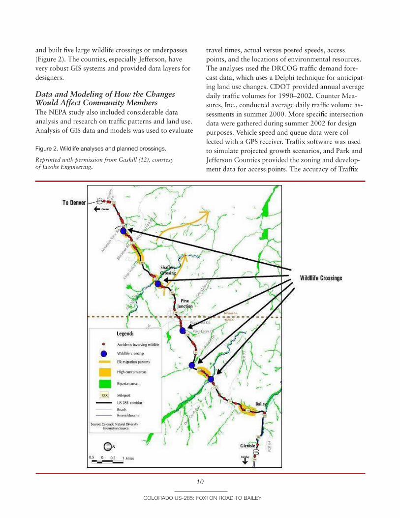
Design teams were able to work around most environmental resources. The project avoided 44 wet-land sites (a total of 3 acres), and eight historic prop-erties. It designed around nine tributary drainages
xton road to Bailey
and built five large wildlife crossings or underpasses (Figure 2). The counties, especially Jefferson, have very robust GIS systems and provided data layers for designers.
Figure 2. Wildlife analyses and planned crossings.
Reprinted with permission from Gaskill (�2), courtesy of Jacobs Engineering.
Data and Modeling of How the Changes Would Affect Community MembersThe NEPA study also included considerable data analysis and research on traffic patterns and land use. Analysis of GIS data and models was used to evaluate
Colorado US-285: Fo
�0
travel times, actual versus posted speeds, access points, and the locations of environmental resources. The analyses used the DRCOG traffic demand fore-cast data, which uses a Delphi technique for anticipat-ing land use changes. CDOT provided annual average daily traffic volumes for 1990–2002. Counter Mea-sures, Inc., conducted average daily traffic volume as-sessments in summer 2000. More specific intersection data were gathered during summer 2002 for design purposes. Vehicle speed and queue data were col-lected with a GPS receiver. Traffix software was used to simulate projected growth scenarios, and Park and Jefferson Counties provided the zoning and develop-ment data for access points. The accuracy of Traffix
xton road to Bailey
was calibrated using a combination of 24-h and peak figures, which were compared to the volumes gener-ated by DRCOG. This was all guided by consulting the Trip Generation Manual (6th ed.), published by the Institute of Transportation Engineers.
The two counties provided population data, as well as zoning and potential rezoning information. This was used to build a profile of county growth patterns and business needs, and to align the objec-tives of these groups. Other plans, both long-range development plans and for other major projects, were closely examined, and included the CDOT Bicycle Corridors report of 2000, and the USFS State of Colorado Wildfire Hazard Mitigation Plan (2001); Jefferson County Mountain Groundwater Resource Study; Jefferson County Open-Space Master Plan; Park County Land Use Regulations; 2002 Park County Profile; State of Colorado Wildfire Hazard Mitigation Plan (2001); the EIS from 1986 for the section of US-285 to the northeast; and the Guanella Pass Road Supplemental Draft EIS and traffic study.
VE and Small and Large Public Meetings, Which Led to Design Adjustments to Improve Aesthetics and Reduce CostsThe VE team met for a week to review alternatives and recommend changes. They also held three public workshops on project design. An interesting turn of events occurred at one of the public neighbor-hood meetings. “During a public meeting, one of the residents came and said, ‘Oh, they are putting in an interchange.... I live right there, and I don’t want to see that bridge.’ I said, ‘We can come to your neigh-borhood and have a meeting.’” From the meetings, it was determined that the public did not want this in-terchange. “We gave them all the data. The majority of the people who were going to use the interchange said, ‘No, we don’t want to see it.’” As a result, an entire interchange at Wisp Creek was completely eliminated from the design (8).
The majority of the process is best character-ized as design refinement. Some of the primary design controls were predetermined to a degree. Earlier phases of widening that had taken place on US-285 from Denver south to the project area shaped driver expectations; in order to be safe, this section had to
Colorado US-285: Fo
��
match the design speed and driver expectations of other sections of the road. Most of the US-285 corri-dor is consistent with CDOT’s “Rolling” designation, which requires a design speed of 60 mph (CDOT Design Guide, 1995). For this project, design was probably 15–20 percent for the NEPA process; “there are some projects where, in order to determine the right solution, you don’t need a lot of design.”
Curbing Sprawl Through Access Control and Intersection DesignThe other main issue, one of the biggest among the community and the planning organizations, was the potential for sprawl, or induced growth. Traffic data showed that widening the road to Bailey would solve foreseeable traffic for 20 years. That established the physical limits of project. The local governments supported the project for commuting and conges-tion relief, but did not want to encourage sprawl. A Transit Feasibility Working Group and a Land Use Committee helped develop land use forecasts and determine levels and locations for induced growth. The Land Use Committee for the feasibility study also helped to create the 2001 Strategic Master Plan for Park County. The NEPA study examined those data, as well as the Conifer/285 Corridor Area Com-munity Plan (1987, but revised 2002) and the 2002 Park County Profile, Demographic and Economic Overview. CDOT was able to convince DRCOG that carefully designed access points would limit sprawl. The idea was that widening would facilitate traffic flow, but the design of the access points would re-strict the ability to develop surrounding land. Access times for each driveway and public road, the turn-ing movement conflict points, and visual simulations were all modeled in GIS.
Final NEPA Considerations and DecisionsIn fall 2003, as the preferred alternative was being developed, CDOT environmental staff consulted FHWA on the progress of the US-285 EIS document. FHWA recommended that CDOT develop more al-ternatives to have an adequate EIS. One interviewee for this case study recalled a legal ruling against FHWA in San Francisco as the impetus for this, but the circumstances are unclear. According to most of
xton road to Bailey
the project team, there weren’t a lot of options. As an existing mountainous highway, the alignment could be shifted only slightly. However, FHWA, CDOT, EPA, and USACE found ways to avoid and minimize impacts (�2). Because of these changes, it was agreed that an EA would be the better level of documenta-tion. In December 2003 the environmental study was downgraded to an EA.
It was at approximately the same time that the project was partially funded by DRCOG. Half of the project area is within the range of the Denver MPO (DRCOG), but they had their attention focused on larger projects, such as T-REX. DRCOG only began to plan for the project in fall 2003, after much of the initial conceptual and environmental work was com-pleted. The project was still a CDOT initiative.
Perhaps the most important element in the NEPA process was the determination of termini for the capacity improvement project. The alternatives in the documents included projects like a Bailey bypass to keep highway traffic out of the town. The traffic projections, however, indicated that enough cars exited the roadway before Bailey that a bypass was unnecessary at this time. Future planners could make that decision if necessary. The preferred alter-native from the EA included widening to four lanes from Foxton Road to beyond Crow Hill, a very steep section just north of Bailey. Some intersection im-provements would be done in the town of Bailey to smooth the flow of traffic.
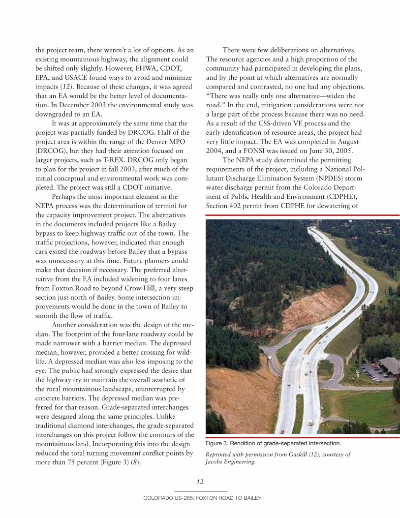
Another consideration was the design of the me-dian. The footprint of the four-lane roadway could be made narrower with a barrier median. The depressed median, however, provided a better crossing for wild-life. A depressed median was also less imposing to the eye. The public had strongly expressed the desire that the highway try to maintain the overall aesthetic of the rural mountainous landscape, uninterrupted by concrete barriers. The depressed median was pre-ferred for that reason. Grade-separated interchanges were designed along the same principles. Unlike traditional diamond interchanges, the grade-separated interchanges on this project follow the contours of the mountainous land. Incorporating this into the design reduced the total turning movement conflict points by more than 75 percent (Figure 3) (8).
Colorado US-285: Fo
�2
Figure 3. Rendition of grade-separated intersection.
Reprinted with permission from Gaskill (�2), courtesy of Jacobs Engineering.
There were few deliberations on alternatives. The resource agencies and a high proportion of the community had participated in developing the plans, and by the point at which alternatives are normally compared and contrasted, no one had any objections. “There was really only one alternative—widen the road.” In the end, mitigation considerations were not a large part of the process because there was no need. As a result of the CSS-driven VE process and the early identification of resource areas, the project had very little impact. The EA was completed in August 2004, and a FONSI was issued on June 30, 2005.
The NEPA study determined the permitting requirements of the project, including a National Pol-lutant Discharge Elimination System (NPDES) storm water discharge permit from the Colorado Depart-ment of Public Health and Environment (CDPHE), Section 402 permit from CDPHE for dewatering of
xton road to Bailey
construction areas, Section 401 Water Quality certifi-cation from CDPHE, USACE 404 permit, CDW Sen-ate Bill 40 certification for stream crossings, FHWA access approval, Nest Take permit from USFWS, Fugitive Dust permit, State Access permit, Construc-tion Access permits, access permits from FHWA and CDOT for new grade separations, and Floodplain Development permit.
Permits still have not been obtained, but there is every reason to believe they will be approved swiftly.
lESSonS lEarnEdThe US-285 widening from Foxton Road to Bailey represents the convergence of a number of collabora-tion-based ideas in transportation planning, such as the following:
• Mergers of multiple regulatory processes;• Continuity and minimization of time gaps in the
planning and project development processes;• Early commitment to environmental stewardship;• Serious engagement of resource agencies and NGOs
from the start;• Willingness to gather large-scale environmental
information (such as the aerial photography) to support early, planning-level consensus building and decision making and to avoid revisiting deci-sions later;
• In-field multiagency meetings, solution seeking, and decision making;
• Small neighborhood and one-on-one meetings;• CSS-VE integration; and• Flexible design.
Most of these concepts are captured in the general theme of CSS. In this case, context sensitivity appears to be based largely on informed alternatives resulting from resource knowledge and transparent decision making, with public input and direction. Implementation of these organizational concepts by an experienced and professional team of planners created a successful process for US-285. One inter-viewee said, “I’ve never seen a project that went bet-ter anywhere, ever.” Specific success factors, innova-tions, and solutions are discussed below.
Colorado US-285: Fo
�3
Success factors
Proactive Management of Environmental ResourcesThis project was largely about the management of environmental resources. One interviewee claimed, “There were no significant issues environmentally”; however, the project area is scenic, rural, and moun-tainous, a home to wildlife as well as people. The lack of environmental issues was the result of stra-tegic design. The feasibility study, which produced early data on corridor resources, allowed for early involvement by agencies and a focused NEPA pro-cess. One participant noted, “When design accounts for resources from the start, you can really save time and effort.”
The conceptual designs reflected the early iden-tification and mapping of resources, including eight properties that were either on or eligible for inclusion on the National Register of Historic Places; 44 wet-land sites, including nine tributary drainages to the South Platte River; wildlife habitat; high scenic values including mountain views; existing open spaces; wa-ter quality concerns; and noise and air quality issues (8). Through collaborations in meetings, in the field, and in design, more than 3 acres of wetland impact was avoided, resulting in final wetland impacts of less than 1 acre. Alignment shifts and retaining walls were used to completely avoid all direct impact to six historic properties, thus eliminating the need for Section 4(f) analysis. The project team identified five locations for wildlife crossings, worked extensively to minimize visual impacts of the project, and was able to effect other beneficial environmental outcomes such as open space preservation, improved water quality treatment during construction and operation, and noise minimization.
Early Action to Address a Pressing Safety IssueBecause of the major accident issues identified at Richmond Hill, a breakout project at this loca-tion was advanced out of the NEPA process and developed as a categorical exclusion to reduce the time to construction. The efficiency of the NEPA process allowed for this part of the improvement to
xton road to Bailey
get a head start. The Richmond Hill project broke ground in March 2006, and is now under way with a construction budget of $11 million (8). The bridge was designed to preserve views and frame surround-ing vistas with an aesthetically pleasing bridge with slant-leg piers. Extensive interaction with fire and safety personnel resulted in cost-effective operational improvements in the firehouse area; relocating the ac-cess roadway allowed space for vehicle movements, while providing safe access to US-285.
FlexibilityIn conducting interviews for this case study it was clear that flexibility was a major element of the pro-cess. In some cases this may simply have been a mat-ter of attitude, with a perception of flexibility. The positive attitude and sense of flexibility led to height-ened stakeholder trust and buy-in. As one participant noted, “The project also improved relationships with a community that has not traditionally held a very high opinion of the CDOT.” This is important because trust built in one project can lead to other partnerships and collaborations. Accolades included the following:
• “CDOT Region 1 was open to environmental concerns more [on this project than other agencies have been on other projects]. They had a good con-sultant that did great outreach, and did [a] good engineering job.”
• “CDOT and Carter & Burgess really had a flex-ible perspective that accounted for environmental resources and public concerns.”
• “The contractor Carter & Burgess had this guy who was truly awesome. He was willing to roll up his sleeves and talk to people, suggest design changes, but at the same time be sensitive to the resource context. He could really discuss the vari-ables in a levelheaded way. Did a great job.”
• “The only trade-off was a willingness to listen to and consider ideas from the public and incorporate them into designs.”
Transparency and Commitment to Cooperation and Consensus BuildingAn element of the community trust was based on the interactions and transparency of decisions. “We
Colorado US-285: Fo
�4
saw engineers saying, ‘Well, we could do this.’ It was done very well.” All interviewees for this case study agreed that decisions were made clearly, they were transparent, and they were based on consensus. It is difficult to quantify this as an element of the project, but it certainly smoothed the process and left a last-ing impression on all.
Context Sensitive SolutionsThe factors above—environmental sensitivity, flexibility, and transparency and participation in decision making—were part of what made the US-285 project an example of CSS. The director of EPA Region 8 NEPA Programs specifically recog-nized the US-285 project for its use of CSS to avoid and reduce environmental impacts, noting, “Out-standing work was done by CDOT and its consul-tants. This is a great example of how impacts can be minimized.” Similarly, USACE noted the “excellent job the participants have done in avoiding and minimizing impact to the aquatic ecosystem” (8).
Early and Consistent CommunicationEarly communication seems to be the central ele-ment of the successful CSS process. “It was just early communication. We did make some changes to the design.... Mostly we kept residents informed so that they didn’t get surprised or get mad and think that you are shoving a design down their throat.” Early and ongoing communication has several effects, but one of the most important is minimizing drastic changes later.
In the words of one resource specialist, “My role is being overstated.” Early involvement, well before major design decisions, enables many resource issues to be worked out or around, minimizing im-pacts that might otherwise be significant. The multi-disciplinary approach was especially effective in parts of the corridor that had wetland resources on one side of the road and historic properties on the other side. Agreements were reached between USACE and SHPO on these areas, facilitated by meetings in the field (�2). “The mergers and ultimate CSS process [were] a definite beneficial trade-off. Time and money [were] saved in the NEPA process, significantly less environmental impact was achieved, [and] ... CDOT
xton road to Bailey
got major points with the public and emerged with [a] very favorable reputation.”
VE to Reduce Costs and Increase ValueOne clear success of the project was VE to reduce costs and increase value. The CSS process resulted in a capacity improvement alternative that saved over $59 million, addressed the purpose of and need for the project, reduced preparation and review time, and allowed an early action breakout project to proceed independently, addressing a critical safety concern (�2). Savings were the result of the various efficiencies and design solutions applied during the NEPA process. By downgrading the document from an EIS to an EA, the project saved at least 8 months of time and approximately $500,000 in study costs. Cost savings may be summarized as follows (�2):
• Wetland mitigation, $200,000 saved;• Downgrade of the EIS to an EA, $500,000 saved;• Use of grade-separated intersections, $55 million
saved;• Elimination of grade-separated intersection at Wisp
Creek, $6 million saved; and• Use of CDOT personnel, $200,000 saved in costs
otherwise committed.
Despite some of the stereotypes about VE, this exercise was not merely focused on cost reduction. Additional costs were incorporated to increase value, including the following:
• Use of wildlife underpasses, $2 million added;• Additional culverts for small wildlife crossing,
$100,000 added; and• Additional aesthetic treatment at bridges, $250,000
added.
innovations and SolutionsThe process was considered highly efficient by nearly all participants. Issues were so successfully addressed and resolved that interviewees generally could not answer questions about stumbling blocks, problems, or what might have worked better. No one men-tioned tough decisions or problems with US-285, and even the word “issues” seemed a little strong for most circumstances. Early interaction with the public
Colorado US-285: Fo
�5
and with resource agencies prevented potential issues from developing down the line. This was a simple innovation of timing within the process. Most of the techniques and methodology were in fact quite typi-cal, with a few exceptions.
Timing, Interaction, Collaboration, and a Creative VE-CSS ProcessElements of the US-285 project that might be con-sidered innovative are mainly in the areas of process, interaction, and collaboration. Decisions emerged from an open and transparent process and were sus-tained from the feasibility study through the NEPA and project development process. The creative use of VE and CSS for this project made the process more efficient.
Successful Downgrading of EIS to EA: Interim Assessment of NEPA Class of Action DeterminationFHWA agreed to downgrade this project from an EIS to an EA because, through the design of the proj-ect, the project team was able to avoid and mitigate environmental impacts uncovered during the feasibil-ity study. Such downgrading is not typical, because the level of documentation depends on the level of environmental impact; the feasibility study allowed the project team to understand impacts before start-ing the NEPA process. Several interviewees made comments related to the rigid nature of the environ-mental process and levels of documentation. “The biggest issue with the entire NEPA process is trying to align data collection to what really matters.” In this case the feasibility study went a long way toward doing just that. “At the start you assume the worst-case scenario, which is the EIS.” FHWA’s flexibility in agreeing to change the level of documentation was a central turning point of this project.
One interviewee suggested that it might be ef-fective to develop an interim assessment of the level of effort for NEPA. The idea was that once you’ve identified your best-case solution, an EIS can easily turn into an EA. If there was a step included in the NEPA process for evaluating resources and design requirements, and reconsidering the NEPA class of action determination, unnecessary data gathering and expense might be avoided, especially because
xton road to Bailey
agencies often choose a higher level of documenta-tion, when in doubt, to be on the safe side. The Council on Environmental Quality advises against this tendency, because an EA is intended to discover whether significant impacts are in evidence. DOTs are increasingly exploring what can be accomplished and how environmental protections may be retained with lower class of action determinations, especially categorical exclusions, as discussed in NCHRP 25-25/Task 13 and in the delegation provisions of Safe, Accountable, Flexible, Efficient Transportation Equity Act: A Legacy for Users (SAFETEA-LU).
SHPO InvolvementEarly SHPO involvement in the US-285 project was an unusual tactic of highway planning, especially in 2002. SAFETEA-LU now emphasizes the integration of cultural resources in the planning stages. Earlier legislation suggested the approach, but it is now a stronger directive. One interviewee expanded on the fact that Section 106 can be worked into NEPA much better than it has typically; “too often it is separated and isolated.” CDOT asked SHPO to be a cooperat-ing agency on this project, which had never occurred before. The offer was not formally accepted for the NEPA process, but as an overture to collaboration, it was apparently a prudent move. SHPO was not kept in a purely regulatory role, but instead felt in-volved and empowered. “Lots of the money spent on historical sites, as well as the destruction of historic resources, could be avoided with more cooperation early on in the process,” such as occurred on US-285.
The extent to which SHPO collaboration can be extrapolated to other projects will vary. CDOT had in-house archaeological staff, and the SHPO specialist provided input mostly on architectural history. The project area was near the state capital, and was not extremely large. According to another interviewee, “This was a very small project, about an hour from Denver. I took part of a day and traveled to the project location to look around. It was definitely very helpful, but it’s impractical for most projects.” SHPOs are generally underfunded and understaffed. They can afford neither the travel budget nor employee time away. The corollary is that clever solutions for obtain-ing SHPO involvement would be highly desirable.
Colorado US-285: F
�
They should be inexpensive, conducted early in the process, and likely would have to be worked out on a case-by-case basis. One suggestion was the use of video that showed the project area and nearby struc-tures that might be affected by construction.
Integrated Design ConsiderationsIn terms of design, “they did a design-level ROW [right-of-way] plan and mapping survey on the corridor—which we wouldn’t normally need for the NEPA process.” Level and timing of design were linked into the feasibility study. More time and money were spent on the feasibility study than normal; however, the information allowed for a more focused NEPA process. A number of wildlife crossings—five 12-ft-high ones for large animals and numerous culvert-style ones for smaller animals—were built into the preliminary design right from the beginning. This allowed the engineers to factor these into the plans, rather than trying to retrofit them as an afterthought, without sufficient budget.
CDOT and the consultant invested a fair amount of analysis in the depressed median and shoulder widths. The road template—the cross sec-tion with a depressed median and shoulder—drove width and curvature of road, as well as design speed. This is important because when drivers face sudden changes in the expected severity of the curves they encounter, accidents often result. A depressed median is safer, because it gives recovery room for errant drivers. Mountain highways tend to be less safe and the corridor had its own safety challenges, and so this was important to the community. A depressed median also allows for turn lanes and safer move-ments, and the grassy median is a recovery area for animals trying to get across the highway. Environ-mental groups and CDOT biologists felt this was very important, but a depressed median results in a wider footprint. Designers and engineers performed several iterations of horizontal and vertical align-ments to get to a wider highway that would still fit within canyonlike portions with relatively few cuts and disturbances to waterways and properties. An 8-ft-wide outside shoulder offered the best trade-off for broken-down vehicles. The community thought very highly of the “mini-interchanges” with over- or
oxton road to Bailey
6
underpasses, plus right in/right out on either side of the freeway, so these solutions were retained. Such approaches take less space. They can also be snaked around problem areas, and still function quite well as long as traffic volume is not too high. A prelimi-nary design was done for every interchange location, building in these solutions right from the start.
Need for Better Estimation Earlier in the ProcessFunding is the biggest issue on many highway proj-ects, and funding changes from year to year. Funding can affect every aspect of a highway project. Conse-quently, funding can be leveraged in selective ways by decision makers within a project. Safety is a signifi-cant premise for additional highway capacity, and when funding is tight, environmental considerations are relegated to a lower priority behind safety con-cerns. An example of this can be seen on the US-285 project. When costs needed to be cut after the NEPA process had been completed, the wildlife underpass at Shafer’s Crossing was proposed for removal from the plans. As one participant explained, “It is easier to cut out costs driven by environmental issues because no one wants to cut safety features.” The cost cuts were made without realizing their significance to the planning and design arrangement. One interviewee said it made CDOT look like it had overcommitted to the community, and this could have seriously eroded CDOT’s credibility. The crossing feature was restored to the design plans and the project continued without this emerging as the problem it could have been. The issue highlights the complications inherent in carrying a project forward from one process (the NEPA review) to another (design refinement). With tight budgets the different interests on a project— designers, planners, environmental managers—can become competing interests. In the case of US-285 there was close agreement on issues and the under-pass was put back in the design, but the episode highlights the need for better estimation and greater inclusion of all costs early in the process.
Funding remains unresolved for completion of the US-285 project. DRCOG included $15 mil-lion for interim improvements on their section of roadway in 2004. Approximately $79 million was
Colorado US-285: F
�
prioritized in the 2004 State Transportation Improve-ment Program for the project. “The US-285 project actually scored pretty weakly compared to more ‘urban’ projects, but because 285 was a statewide connector, and Region 1 was in relatively better financial shape, the project was included on the fis-cally constrained RTP and TIP.” It is unclear if it is fully funded now. Mitigation plans are still being finalized and no Section 404 permit has yet been issued. Current cost estimates are $180 million, plus the $11 million breakout project. As one interviewee put it, “The transportation system in Colorado is always playing catch-up.”
concluSionThe process of involving agencies early in the US-285 project worked so well that some methods have now become standard procedure. CDOT has now imple-mented a statewide formal merger with USACE on the Section 404 process. The CDOT Environmental Stewardship document, which came out during the US-285 project, has institutionalized concepts that were occasional best practices then. These types of changes aim to take positive examples and turn them into standard practice.
oxton road to Bailey
7
rEFErEncES
1. Colorado Department of Transportation. 2006. US-285 Environmental Study Honored with National Award. Press Release, Dec. 14, 2006.
2. U.S. 285 Environmental Study Honored with National Award. Public Roads, Vol. 70, No. 6, 2007, p. 41. www.tfhrc.gov/pubrds/07may/alongroad.htm. Accessed Feb. 16, 2010.
3. Carter & Burgess, Inc. US-285 Foxton Road to Fairplay Feasibility Study. Technical report. Colorado Department of Transportation Region 1, Denver, March 2002.
4. Carter & Burgess, Inc. US-285 (Foxton Road to Bailey), Jefferson and Park Counties, Colorado, Environmental Assessment. Technical report. Colorado Department of Transportation Region 1, Denver, August 2004.
5. Federal Highway Administration, U.S. Department of Transportation. Case Study—GARVEEs: Southeast Cor-ridor Project (T-REX). In Innovative Finance Primer, April 2002. www.fhwa.dot.gov/innovativefinance/ifp/cssouth.htm. Accessed Feb. 5, 2010.
6. Governor’s Office of State Planning and Budget, Colo-rado. Transportation Revenue Anticipation Notes. Fact Sheet, July 2003.
7. Regional Transportation District of Denver. Transit Ori-ented Development. FasTracks, 2007. www.rtd-denver.com.
8. Kullman, J., and Colorado Department of Transporta-tion. Application: AASHTO Center for Environmental Excellence National Context Sensitive Solutions Competi-tion, 2006.
9. Federal Highway Administration, U.S. Department of Transportation. Federal Register. US-285 Notice of Intent. Vol. 67, No. 134, July 2002, pp. 46241–46242.
10. Federal Highway Administration, U.S. Department of Transportation. Notice of Final Agency Action on Pro-posed Highways in Colorado. Federal Register, Vol. 72, No. 92, May 14, 2007, p. 27170.
11. Environmental Programs Branch, Colorado Depart-ment of Transportation. Evaluation and Mitigation of Environmental Impacts Prior to Project Selection: US 24, MP 3��.7 T0 MP 33�.0, Results of an Assessment of the Corridor Approach for Early Evaluation of Environmen-tal Resources. Report No. CDOT-2007-6. Prepared in cooperation with the U.S. Department of Transportation, Federal Highway Administration, April 2007.
12. Gaskill, C. Cost-Benefit Study of Applying Context Sensitive Solutions to US-285, West of Denver, Colorado. Presented at Transportation Research Board Annual Meet-ing, Washington, D.C., 2007.
Colorado US-285: Foxton road to Bailey
�8
The National Academy of Sciences is a private, nonprofit, self-perpetuating society of distinguished schol-
ars engaged in scientific and engineering research, dedicated to the furtherance of science and technology
and to their use for the general welfare. On the authority of the charter granted to it by the Congress in 1863,
the Academy has a mandate that requires it to advise the federal government on scientific and technical
matters. Dr. Ralph J. Cicerone is president of the National Academy of Sciences.
The National Academy of Engineering was established in 1964, under the charter of the National Academy
of Sciences, as a parallel organization of outstanding engineers. It is autonomous in its administration and in
the selection of its members, sharing with the National Academy of Sciences the responsibility for advising
the federal government. The National Academy of Engineering also sponsors engineering programs aimed at
meeting national needs, encourages education and research, and recognizes the superior achievements of
engineers. Dr. Charles M. Vest is president of the National Academy of Engineering.
The Institute of Medicine was established in 1970 by the National Academy of Sciences to secure the
services of eminent members of appropriate professions in the examination of policy matters pertaining to
the health of the public. The Institute acts under the responsibility given to the National Academy of Sci-
ences by its congressional charter to be an adviser to the federal government and, upon its own initiative, to
identify issues of medical care, research, and education. Dr. Harvey V. Fineberg is president of the Institute of
Medicine.
The National Research Council was organized by the National Academy of Sciences in 1916 to associate
the broad community of science and technology with the Academy’s purposes of furthering knowledge and
advising the federal government. Functioning in accordance with general policies determined by the Acad-
emy, the Council has become the principal operating agency of both the National Academy of Sciences and
the National Academy of Engineering in providing services to the government, the public, and the scientific
and engineering communities. The Council is administered jointly by both Academies and the Institute of
Medicine. Dr. Ralph J. Cicerone and Dr. Charles M. Vest are chair and vice chair, respectively, of the National
Research Council.
The Transportation Research Board is one of six major divisions of the National Research Council. The
mission of the Transportation Research Board is to provide leadership in transportation innovation and
progress through research and information exchange, conducted within a setting that is objective, interdis-
ciplinary, and multimodal. The Board’s varied activities annually engage about 7,000 engineers, scientists,
and other transportation researchers and practitioners from the public and private sectors and academia, all
of whom contribute their expertise in the public interest. The program is supported by state transportation
departments, federal agencies including the component administrations of the U.S. Department of Transpor-
tation, and other organizations and individuals interested in the development of transportation. www.TRB.org


![Index [cds.cern.ch]...Index 803 electrochemical properties, 287 five-level model, 285, 286 ISA, 286 nonlinear absorption, 285 photophysical properties, 285–287 solubility, 285 structure,](https://static.documents.pub/doc/80x56/6064d77b5ba3771e9668db51/index-cdscernch-index-803-electrochemical-properties-287-ive-level-model.jpg)


