ANALYSIS SUMMARY: This analysis is based on an assessment of satellite imagery recorded on 22nd September 2011 following a gas pipeline explosion that took place on 12th September 2011, within the Mukuru-Sinai slums of Nairobi, Kenya. Analysis revealed that the explosion took place in the highly congested Mukuru-Sinai slums along the river Ngongo. This is a preliminary damage assessment, and it is likely to represent a reliable minimum estimate; the actual building damages within this area are likely to be larger. Satellite Data (2): WV02/QB02 Imagery Dates: 20/11/2010, 22/09/2011 Resolution : 0.5 m/0.6 m Copyright:DigitalGlobe 2011 Source: FirstLook Analysis : UNITAR / UNOSAT Production: UNITAR / UNOSAT Analysis conducted with ArcGIS v10.0 Projection: UTM Zone 37 N Datum: WGS 84 The depiction and use of boundaries, geographic names and related data shown here are not warranted to be error-free nor do they imply official endorsement or acceptance by the United Nations. UNOSAT is a program of the United Nations Institute for Training and Research (UNITAR), providing satellite imagery and related geographic information, research and analysis to UN humanitarian & development agencies & their implementing partners. UNITAR/UNOSAT [email protected]Palais des Nations, Geneva, Switzerland T: +41 22 767 4020 (UNOSAT Operations) 24/7 hotline: +41 76 487 4998 NAIROBI, KENYA 22ND SEPTEMBER 2011 Possible site of explosion I Zone of destruction 20 0 20 40 60 10 Meters This work by UNITAR/UNOSAT is licensed under a Creative Commons Attribution-NonCommercial-ShareAlike 3.0 Unported License. Map Scale for A4: 1:2,000 Damage zone Ngong River Destroyed buildings Severely damaged buildings Pipeline Explosion ! ! - Version 1.0 UNOSAT Activation: FR20110913KEN Production Date: 28/09/2011
Transcript
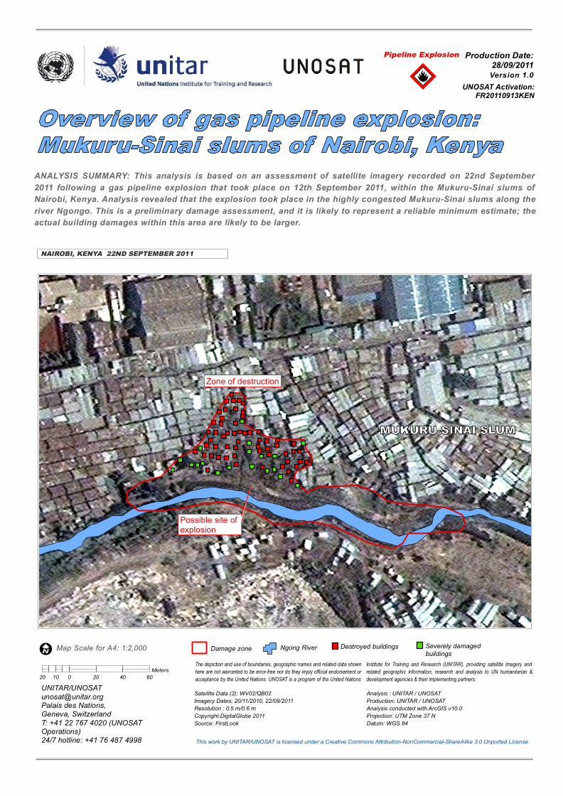
ANALYSIS SUMMARY: This analysis is based on an assessment of satellite imagery recorded on 22nd September2011 following a gas pipeline explosion that took place on 12th September 2011, within the Mukuru-Sinai slums ofNairobi, Kenya. Analysis revealed that the explosion took place in the highly congested Mukuru-Sinai slums along theriver Ngongo. This is a preliminary damage assessment, and it is likely to represent a reliable minimum estimate; theactual building damages within this area are likely to be larger.
Analysis : UNITAR / UNOSATProduction: UNITAR / UNOSATAnalysis conducted with ArcGIS v10.0Projection: UTM Zone 37 NDatum: WGS 84
The depiction and use of boundaries, geographic names and related data shownhere are not warranted to be error-free nor do they imply official endorsement oracceptance by the United Nations. UNOSAT is a program of the United Nations
Institute for Training and Research (UNITAR), providing satellite imagery andrelated geographic information, research and analysis to UN humanitarian &development agencies & their implementing partners.
i This pipeline, owned by the Kenya Pipeline Company Ltd (KPC), is a 450 km pipeline from Mombasa port to Nairobi (Line I), the diameter of which is about 35 cm. Based on reports accessed from KPC website http://www.kpc.co.ke/ on 27/09/2011.
i
Figure 2: Overview map of the region
Image date: 22 September 2011
Kenya Pipeline Company Ltd (KPC)
Zone of damage KPC Mukuru-Sinai slum Gas pipeline Ngongo river Road