31
Fractured Rock and Confined Aquifers Recommendations for Sustainable Management Liquid Earth October 2010
Fractured Rock and Confined Aquifers Recommendations for Sustainable Management
Liquid Earth October 2010
2
Table of Contents
1. Introduction ...................................................................................................................................... 3
1.1 Background ................................................................................................................................ 3
1.2 Key Concepts ............................................................................................................................. 3
2. Current Policy .................................................................................................................................. 9
2.1 Background ................................................................................................................................ 9
2.1 Policies and Objectives .............................................................................................................. 9
2.2 Regional Rules ......................................................................................................................... 10
2.3 Application of Existing Policy Provisions to Management of Confined Aquifers ...................... 12
2.4 Application of Existing Policy Provisions to Management of Fractured Rock Aquifers............ 12
2.5 Limitations of the Current Management Approach .................................................................. 13
2.6 Summary .................................................................................................................................. 14
3. An Alternative Management Approach ......................................................................................... 16
3.1 Management of Confined Aquifers ........................................................................................... 16
3.1.1 Classification ..................................................................................................................... 16
3.1.2 Information Requirements ................................................................................................. 17
3.1.3 Establishing Sustainable Abstraction ................................................................................ 20
3.1.4 Staged Management Approach ........................................................................................ 22
3.1.5 Application of Minimum Level Cut-offs and Seasonal Recovery Criteria.......................... 23
3.1.6 Interference Effects ........................................................................................................... 23
3.2 Fractured Rock Aquifers........................................................................................................... 25
3.2.1 Establishing Sustainable Abstraction ................................................................................ 26
3.3 Sustainable Groundwater Management ................................................................................... 27
3.3.1 Supplementary Allocation ................................................................................................. 27
3.3.2 Common Expiry Dates ...................................................................................................... 28
3.3.4 Realigning Over-Allocation ................................................................................................ 28
4. Summary ....................................................................................................................................... 30
5. References .................................................................................................................................... 31
3
1. Introduction
1.1 Background
Extensive deposits of Quaternary and Tertiary sediments1 in the Southland Region host a number of
confined aquifer systems. These aquifer systems present a challenge for water resource
management due to the limited information typically available to characterise:
The physical extent of individual aquifer systems;
The magnitude and nature of aquifer recharge and discharge;
The hydraulic properties of the aquifer system including storage characteristics; and
The dynamic response of the confined aquifers to groundwater abstraction including potential
effects on hydraulically connected surface and groundwater resources.
Due to their unique hydrogeological characteristics, the requirement to manage confined aquifers in a
different manner to unconfined groundwater resources was recognised in Variation 2 to the Regional
Water Plan (RWP) developed in 2003 which adopted a staged management framework for confined
aquifers based on groundwater level response to abstraction. However, subsequent experience with
large-scale development of confined aquifers in the Northern Southland area suggests that the
effects-based approach adopted in the RWP is not particularly effective in terms of addressing key
resource management issues for confined aquifers, particularly in terms of aquifer sustainability.
A subsequent review of the management of confined aquifers (SKM, 2008) highlighted many of the
shortcomings associated with the existing management framework for confined aquifers and
suggested an alternative approach for determining aquifer sustainability. This report builds on the
SKM (2008) report to provide a series of recommendations to assist development of more effective
policy for the management of confined aquifers.
This report also provides recommendations for the management of groundwater allocation in
fractured rock aquifers. Fractured rock aquifers were recognised as a distinct aquifer type in the RWP
but due to their unique hydrogeological characteristics this aquifer type was not included within the
allocation framework developed. This report addresses this anomaly by recommending a
methodology which may be applied to manage localised allocation from fractured rock aquifers.
The report also canvasses various groundwater resource management issues that apply to all aquifer
types (including confined and fractured rock aquifers) that may be addressed by relatively simple
amendments to the current regulatory framework.
1.2 Key Concepts
The following section provides an introduction to some of the key concepts related to resource
management in confined and fractured rock aquifers.
1 Quaternary sediments refer to those deposited over the last 2 million years and typically include the extensive alluvial gravel
deposits found across the Southland Plains and inland basins. Tertiary sediments refer to those deposited over the period
between 2 and 65 million years before present and include the extensive deposits of lignite, mudstone and limestone that
underlie the Quaternary gravels across much of the Southland Region.
4
Aquifers
The RWP defines an aquifer as a “saturated rock or soil material capable of transmitting and yielding
water in sufficient quantities for abstraction”.
Following this definition there are two key aspects that determine the occurrence of aquifers. The first
is that the geological material has to be fully saturated (as opposed to the unsaturated zone where the
pore spaces in the geological materials are only partially filled with water). The point at which the
material becomes fully saturated defines the water table.
The second key point is that the material must be capable of transmitting sufficient quantities of water
to provide sufficient yield to enable economic quantities of water to be accessed by bores and wells.
As a result, although virtually all geological materials (below the water table) are fully saturated, only
those which have sufficient permeability (i.e. a measure of the ability of the material to transmit water)
are classified as aquifers. Geological materials which are fully saturated but which have low
permeability (i.e. do not readily transport sufficient quantities of water to enable viable groundwater
abstraction) are typically referred to as aquitards. It is noted that while these materials are not
classified as aquifers they may still have the capability to store and transmit appreciable quantities of
water.
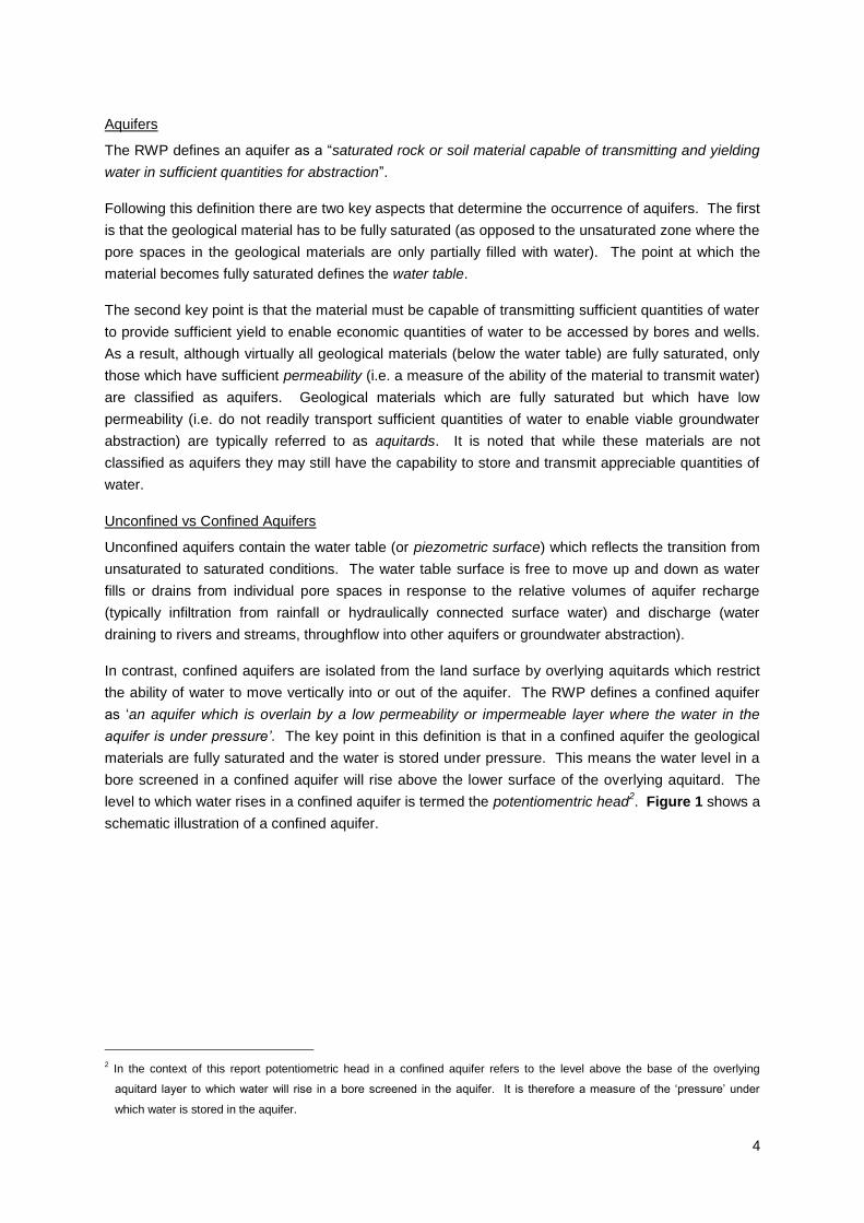
Unconfined vs Confined Aquifers
Unconfined aquifers contain the water table (or piezometric surface) which reflects the transition from
unsaturated to saturated conditions. The water table surface is free to move up and down as water
fills or drains from individual pore spaces in response to the relative volumes of aquifer recharge
(typically infiltration from rainfall or hydraulically connected surface water) and discharge (water
draining to rivers and streams, throughflow into other aquifers or groundwater abstraction).
In contrast, confined aquifers are isolated from the land surface by overlying aquitards which restrict
the ability of water to move vertically into or out of the aquifer. The RWP defines a confined aquifer
as „an aquifer which is overlain by a low permeability or impermeable layer where the water in the
aquifer is under pressure’. The key point in this definition is that in a confined aquifer the geological
materials are fully saturated and the water is stored under pressure. This means the water level in a
bore screened in a confined aquifer will rise above the lower surface of the overlying aquitard. The
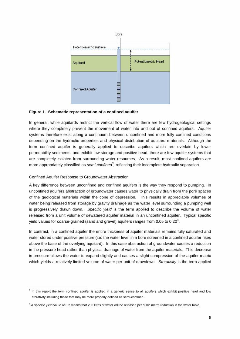
level to which water rises in a confined aquifer is termed the potentiomentric head2. Figure 1 shows a
schematic illustration of a confined aquifer.
2 In the context of this report potentiometric head in a confined aquifer refers to the level above the base of the overlying
aquitard layer to which water will rise in a bore screened in the aquifer. It is therefore a measure of the „pressure‟ under
which water is stored in the aquifer.
5
Figure 1. Schematic representation of a confined aquifer
In general, while aquitards restrict the vertical flow of water there are few hydrogeological settings
where they completely prevent the movement of water into and out of confined aquifers. Aquifer
systems therefore exist along a continuum between unconfined and more fully confined conditions
depending on the hydraulic properties and physical distribution of aquitard materials. Although the
term confined aquifer is generally applied to describe aquifers which are overlain by lower
permeability sediments, and exhibit low storage and positive head, there are few aquifer systems that
are completely isolated from surrounding water resources. As a result, most confined aquifers are
more appropriately classified as semi-confined3, reflecting their incomplete hydraulic separation.
Confined Aquifer Response to Groundwater Abstraction
A key difference between unconfined and confined aquifers is the way they respond to pumping. In
unconfined aquifers abstraction of groundwater causes water to physically drain from the pore spaces
of the geological materials within the cone of depression. This results in appreciable volumes of
water being released from storage by gravity drainage as the water level surrounding a pumping well
is progressively drawn down. Specific yield is the term applied to describe the volume of water
released from a unit volume of dewatered aquifer material in an unconfined aquifer. Typical specific
yield values for coarse-grained (sand and gravel) aquifers ranges from 0.05 to 0.204.
In contrast, in a confined aquifer the entire thickness of aquifer materials remains fully saturated and
water stored under positive pressure (i.e. the water level in a bore screened in a confined aquifer rises
above the base of the overlying aquitard). In this case abstraction of groundwater causes a reduction
in the pressure head rather than physical drainage of water from the aquifer materials. This decrease
in pressure allows the water to expand slightly and causes a slight compression of the aquifer matrix
which yields a relatively limited volume of water per unit of drawdown. Storativity is the term applied
3 In this report the term confined aquifer is applied in a generic sense to all aquifers which exhibit positive head and low
storativity including those that may be more properly defined as semi-confined.
4 A specific yield value of 0.2 means that 200 litres of water will be released per cubic metre reduction in the water table.
6
to describe the storage characteristics of confined aquifers which commonly lie in the range of 0.001
to 0.000015.
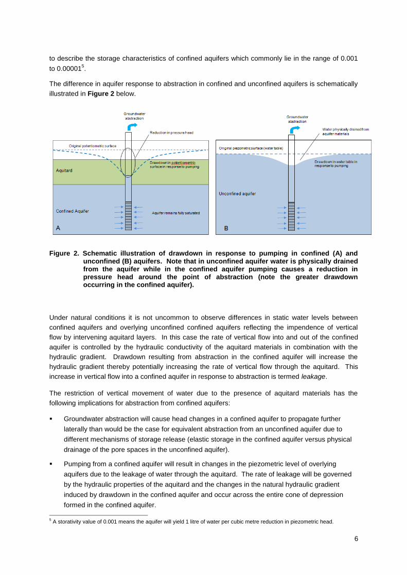
The difference in aquifer response to abstraction in confined and unconfined aquifers is schematically
illustrated in Figure 2 below.
Figure 2. Schematic illustration of drawdown in response to pumping in confined (A) and unconfined (B) aquifers. Note that in unconfined aquifer water is physically drained from the aquifer while in the confined aquifer pumping causes a reduction in pressure head around the point of abstraction (note the greater drawdown occurring in the confined aquifer).
Under natural conditions it is not uncommon to observe differences in static water levels between
confined aquifers and overlying unconfined confined aquifers reflecting the impendence of vertical
flow by intervening aquitard layers. In this case the rate of vertical flow into and out of the confined
aquifer is controlled by the hydraulic conductivity of the aquitard materials in combination with the
hydraulic gradient. Drawdown resulting from abstraction in the confined aquifer will increase the
hydraulic gradient thereby potentially increasing the rate of vertical flow through the aquitard. This
increase in vertical flow into a confined aquifer in response to abstraction is termed leakage.
The restriction of vertical movement of water due to the presence of aquitard materials has the
following implications for abstraction from confined aquifers:
Groundwater abstraction will cause head changes in a confined aquifer to propagate further
laterally than would be the case for equivalent abstraction from an unconfined aquifer due to
different mechanisms of storage release (elastic storage in the confined aquifer versus physical
drainage of the pore spaces in the unconfined aquifer).
Pumping from a confined aquifer will result in changes in the piezometric level of overlying
aquifers due to the leakage of water through the aquitard. The rate of leakage will be governed
by the hydraulic properties of the aquitard and the changes in the natural hydraulic gradient
induced by drawdown in the confined aquifer and occur across the entire cone of depression
formed in the confined aquifer.
5 A storativity value of 0.001 means the aquifer will yield 1 litre of water per cubic metre reduction in piezometric head.
7
Fractured Rock Aquifers
Fractured rock aquifers are distinct from groundwater systems which are hosted in sedimentary
deposits. While sedimentary aquifers store and transmit water through pore spaces between
individual sediment granules, fractured rock aquifers store and transmit water through crevices, joints
and fractures in an otherwise impervious rock mass. As a result, fractured rock aquifers exhibit
hydraulic characteristics which are distinct from those observed in sedimentary aquifer systems with
water availability (commonly observed in terms of bore yield) generally dependent on the nature
(number, size and extent) of discontinuities in the rock mass and their degree of interconnection. This
means the long-term yield available from bores screened in fractured rock aquifers is generally
dependent on the localised extent and interconnection of discontinuities in the overall rock masses
rather than permeability of the geological materials in the immediate vicinity of the abstraction point.
Fractured rock aquifers may also exhibit different recharge characteristics to other aquifer types,
particularly unconfined aquifers. Fractured rock aquifers typically occur in rolling to steep topography
where the percentage of rainfall contributing to surface water runoff is significantly higher than more
flat-lying areas. In addition, due to the age of the geological units forming fractured rock aquifers
(typically pre-Tertiary age) extensive weathering commonly occurs along the upper surface of the rock
mass. This weathering commonly results in the alteration of the rock materials to form clay minerals
which inhibit the vertical movement of water. Permeability in fractured rock aquifers may also reduce
with depth due to the progressive reduction in open space along joints and fractures due to the weight
of the overlying rock mass.
Aquifer Sustainability
Sustainability is often a difficult concept to define in a precise manner and with universal applicability
in terms of natural resource management. Section 5(2) of the Resource Management Act (1991)
defines sustainable management in terms of:
‘...managing the use, development and protection of natural and physical resources in a way, or at a
rate, which enables people and communities to provide for their social, economic and cultural
wellbeing and for their health and safety while:
a) Sustaining the potential of natural and physical resources (excluding minerals) to meet the
reasonable foreseeable needs of future generations; and
b) Safeguarding the life-supporting capacity of air, water, soil and ecosystems; and
c) Avoiding, remedying or mitigating any adverse effects of activities in the environment.
The USGS (Alley et al, 1999) define ground-water sustainability as the „development and use of
ground water in a manner that can be maintained for an indefinite time without causing unacceptable
environmental, economic, or social consequences‟. Similarly the Australian government National
Water Initiative (NWI)6 defines sustainable groundwater abstraction as ‘the level of water extraction
from a particular system which, if exceeded would compromise key environmental assets, or
ecosystem functions and the productive base of the resource‟. Both definitions illustrate the degree of
subjectivity inherent in defining an „acceptable‟ level of abstraction that does adversely impact on the
values associated with a particular groundwater resource.
6 http://www.nwc.gov.au/www/html/180-sustainable-management.asp
8
In the New Zealand context, aquifer sustainability typically relates to management of an individual
aquifer system in a manner which maintains those values associated with the groundwater resource.
These values depend on the physical characteristics and use associated with a particular
groundwater resource and may relate to a combination of factors such as:
Effects on existing groundwater users;
Maintenance of aquifer storage to ensure continued access to the resource (i.e. the overall
volume of water in the aquifer system is not depleted over time);
Potential effects on hydraulically connected surface water bodies such as rivers, streams and
wetlands; and
Maintenance of groundwater quality suitable for a particular end use (e.g. drinking water).
9
2. Current Policy
2.1 Background
Development of a detailed framework for groundwater management in the Southland Region for the
current Regional Water Plan is complicated by limited knowledge of regional hydrogeology and the
comparatively short history of both resource development and environmental monitoring and
investigations.
In response to a significant increase in the consumptive groundwater use, Environment Southland
initiated Variation 2 to the Regional Water Plan in 2003 to develop a more robust framework for
managing the regions groundwater resources. This variation adopted a staged approach to the
allocation of groundwater within nominated management zones. Each individual management zone
identified was classified according to „aquifer type‟ and nominal allocation volumes for each aquifer
type attributed varying activity status (e.g. restricted discretionary, discretionary and non-complying)
according to the potential risk of adverse environmental effects associated with groundwater
abstraction.
The basic premise of the management framework was the concept of adaptive management whereby
the level of information and assessment required to support an individual resource consent
application to take groundwater escalate as the level of allocation increases. As a consequence, the
allocation framework does not establish definitive allocation limits, rather it recognises that the
establishment of limits to consumptive groundwater use will, in a practical sense, only be determined
through an iterative process involving further investigations, monitoring and resource development.
The overall philosophy being to establish a management framework which enables information
derived from progressive resource development to inform the resource consent decision-making
process as a groundwater resource is progressively developed.
The Regional Water Plan (RWP) defines five basic aquifer types in the Southland Region (riparian,
lowland, terrace, confined and fractured rock) and establishes preliminary allocation limits for riparian,
lowland and terrace aquifers based on varying percentages of mean annual land surface recharge
(LSR). Due to the limited knowledge of the spatial extent, hydrogeology and recharge characteristics
at the time of plan development, such an approach was not considered appropriate for confined or
fractured rock aquifers. As an alternative, criteria to manage allocation from confined aquifers were
established on the basis of potential drawdown of groundwater levels in response to abstraction. No
criteria were established to cover allocation from fractured rock aquifers
The following section provides a summary of current policy relating to groundwater allocation from
confined and fractured rock aquifers and outlines some of the practical difficulties encountered
implementing the current approach to management of confined aquifers through the resource consent
process.
2.1 Policies and Objectives
The policies and objectives outlined in the Regional Water Plan relevant to the management of
confined aquifers include:
10
Objective 9 – Sustainable abstraction
To ensure that the total volume and rate of groundwater abstraction is sustainable
Policy 28 - To Manage Groundwater Abstraction
To manage groundwater abstraction to avoid significant adverse effects on:
long-term aquifer storage volumes
existing water users
surface water flows and aquatic ecosystems and habitats
groundwater quality
Policy 30 – Groundwater abstraction
a) Use a staged management approach to allocate groundwater for abstraction in Southland to
allow the knowledge gained by the progressive development of the region’s groundwater
resources to be built into its future management
b) Recognise the different characteristics of the following aquifer types when managing
groundwater abstraction:
i. riparian aquifers
ii. terrace aquifers
iii. lowland aquifers
iv. confined aquifers
v. fractured rock aquifers
c) Provide for a level of permitted groundwater abstraction where there is a minimal risk of
adverse effects
Policy 31 - Interference Effects
Limit the interference effect of any new groundwater abstraction to no more than 20 percent of the
available drawdown in any neighbouring bore provided the neighbouring bore is lawfully
established and adequately penetrates the aquifer
2.2 Regional Rules
Rules defining the activity status of groundwater abstraction from confined aquifers are defined in:
Rule 23 – Abstraction and Use of Groundwater7
a) In addition to takes authorised by Section 14(3) of the Act and the abstraction and use of
groundwater permitted under Rule 23 (b), the abstraction and use of up to 20,000 litres of
groundwater per landholding per day is a permitted activity provided the following conditions are
met:
(i) The rate of abstraction does not exceed 2 litres per second, except where the abstraction
is for the purpose of carrying out an aquifer test or hydrological study; and,
7 It is noted that Rule 23 does not include provision for fractured rock aquifers.
11
(ii) The abstraction does not result in adverse effects on existing water users, surface water
ecosystems or groundwater quality
c) Except as provided for in Rules 23(a) and 23(b) and the takes authorised by Section 14(3) of the
Act, the abstraction and use of groundwater from any of the following sources is a restricted
discretionary activity, provided the rate of take is less than or equal to 2 litres per second
(ii) A confined aquifer where pumping of an individual bore results in a maximum reduction of
less than 25 percent in the potentiometric head at a distance of 250 metres from the
pumped bore
d) Except as provided for in Rules 23 (a) and 23(b) and the takes authorised by Section 14(3) of the
Act, the abstraction and use of groundwater from any of the following sources is a discretionary
activity:
(iii) A confined aquifer where pumping of an individual bore results in a maximum reduction of
between 25 and 50 percent in the potentiomentric head at a distance of 250 metres from
the pumped bore.
e) Except as provided for in Rules 23 (a) and 23(b) and the takes authorised by Section 14(3) of the
Act, the abstraction and use of groundwater from any of the following sources is a non-complying
activity:
(iii) A confined aquifer where pumping of an individual bore results in a maximum reduction of
between 25 and 50 percent in the potentiomentric head at a distance of 250 metres from
the pumped bore.
Appendix A of the Regional Water Plan also outlines information required to be submitted to support
applications for resource. These information requirements are of direct relevance to the assessment
and management of potential environmental effects associated with groundwater abstraction and
include:
In the case of a groundwater take from a confined aquifer, the assessment of environmental effects
outlined above shall include:
appropriate bore construction standards
an analysis of aquifer leakage
interference effects
radius of influence
net use
saltwater intrusion potential
estimation of aquifer recharge/discharge characteristics
Where the take is a discretionary activity under Rule 23, the assessment shall also include:
hydrochemical identification of recharge sources
a detailed assessment of water balance
an assessment of the impact of abstraction on adjacent water resources (throughflow, spring
discharge, leakage
Where the take is a non-complying activity under Rule 23, the assessment should also include (in
addition to the matters outlined above):
12
numerical modelling
2.3 Application of Existing Policy Provisions to Management of Confined
Aquifers
As a result of groundwater development occurring since the early 2000‟s, at least four separate
confined aquifer systems have been identified in the Southland Region. These include the Lumsden,
North Range and Lintley aquifers in the Oreti Basin and the Garvie Aquifer underlying the
Wendonside Terrace in the Mataura catchment. The Tertiary lignite measure deposits of the Eastern
Southland Group which underlie Quaternary gravel deposits across the Southland Plains and Waimea
Valley also host an extensive, but poorly defined, system of confined aquifers. Confined aquifers
may also be present in other areas of Southland such as the Aparima Catchment and Te Anau Basin
where to date there has been limited exploration of the groundwater resource potential below the
shallow unconfined aquifers.
In many cases due to the limited data available to characterise aquifer hydrogeology, resource
consent applications in confined aquifers have presented a challenge for groundwater resource
management, particularly in terms of assessing aquifer sustainability and potential cumulative well
interference effects. In order to provide a means of allocating water that addresses long-term aquifer
sustainability and the potential effects of abstraction on the reliability of supply for existing users a
majority of consents have been subject to conditions that include:
A condition limiting the rate of abstraction to no more than 50 percent of the maximum
consented rate if groundwater levels in a nominated monitoring bore reach an initial trigger
level;
A condition requiring abstraction to cease when groundwater levels in a nominated monitoring
bore fall below a second trigger level (generally set at 1 metre lower than the initial trigger
level); and
A condition triggering a review of consent if seasonal recovery is inadequate (typically
determined as either metre drop in groundwater levels between the commencement of
consecutive irrigation seasons that exceeds a nominated figure or a larger decline in levels
over three consecutive irrigation seasons).
These conditions have typically been intended to implement the intent Rule 23 c, d and e (in terms of
aquifer drawdown). However, in reality, these conditions fail to effectively implement the policy intent
of Rule 23, particularly in terms of activity status and provide little guidance as to the potential effect of
further allocation on aquifer sustainability and reliability of supply for existing users. In addition these
conditions have been implemented in a relatively ad hoc manner through the resource consent
process so do not apply universally and equally to all relevant consents.
2.4 Application of Existing Policy Provisions to Management of Fractured
Rock Aquifers
Extensive fractured rock aquifer systems exist in the Southland Region, generally around the
periphery of the Southland Pains and inland basins where Quaternary and/or Tertiary sediments are
absent and basement rocks are exposed near the land surface. These geological units include:
13
The Murihiku Terrane which forms the Catlins Block and Hokonui Hills and underlies much of the
Southland Plains;
The Dun Mountain-Matai and Caples Terrain exposed in hills and mountains in the Northern
Southland area; and
The Brooks Street Terrain which forms the Longwood Range and Takitimu Mountains; and
The various schist and granitoid rocks forming Stewart Island and the Fiordland Mountains.
Fractured rock aquifers may also include groundwater resources hosted within limestone strata within
the Tertiary sediments underlying the more Quaternary gravel deposits. These aquifer systems host
a groundwater resource within jointing and fracturing within the rock mass and in places may also
have developed secondary permeability within solution cavities (e.g. the upper portion of limestone
deposits forming Winton Hill).
As described in Section 1.2, fractured rock aquifers commonly contain extensive groundwater
resources hosted in discontinuities (jointing, fracturing and faulting) within the overall rock mass. Due
to the irregular nature of the secondary permeability in these geological materials, aquifer hydraulic
characteristics and available long-yield are generally highly location-specific. As a consequence,
although different areas of an individual fractured rock aquifer may exhibit similar hydraulic
characteristics, groundwater allocation cannot be managed on a global basis for these aquifers in the
same way it can in sedimentary aquifers. For this reason, although recognised as a distinct aquifer
type in the Regional Water Plan (Policy 30), fractured rock aquifers were not included in the stage
management approach developed for other aquifer types (Rule 23). This means there are currently
no allocation limits set for fractured rock aquifers which extend across a significant area of the
Southland Region and no information requirements outlined in Appendix A.
2.5 Limitations of the Current Management Approach
Experience with the practical application of existing RWP provisions for the management of confined
aquifers suggests that the current policies and rules are not particularly effective for a range of
reasons including:
Provisions of Rule 23 relating to establishing activity status on the basis of potential drawdown at
a point 250 metres from the pumped bore do not provide an effective means of managing
multiple abstractions from confined aquifers, particularly in terms of future allocation and overall
aquifer sustainability;
There is a lack of long-term groundwater level monitoring data which can be utilised to determine
both natural seasonal variation in aquifer storage in relation to climate variability and to
determine the long-terms effects of existing levels of abstraction on aquifer sustainability. It is
also difficult to determine overall aquifer sustainability when actual groundwater use is unknown
or lower than consented volumes;
In the absence of effective rules and policies to manage groundwater abstraction from confined
aquifers, pumping regulation based on minimum groundwater level cut-offs and seasonal
recovery have been implemented via consent conditions on a majority of groundwater takes.
While these measures are able to provide a baseline to ensure aquifer sustainability they provide
14
limited guidance for future allocation and may result in equity issues for individual resource
users;
Current management provisions for interference effects are not particularly effective in terms of
managing the cumulative drawdown effects resulting from abstraction on the reliability of supply
for individual resource users;
The limited ability to factor in the cumulative effects of abstraction on hydraulically connected
water resources, particularly in regard to leakage induced by pumping and the need for
integrated management of unconfined and underlying confined aquifers where appropriate; and
The potential for localised drawdowns to impact on water levels in monitoring bores which are
utilised as a minimum level reference site for a number of consents.
Due to their physical characteristics the absence of allocation limits for Fractured Rock aquifers is not
generally an environmental issue for groundwater management. In this hydrogeological setting the
typically low hydraulic conductivity and limited interconnection between waterbearing zones effectively
limits aquifer sustainability and associated environmental effects (e.g. well interference and stream
depletion) to a localised issue around individual pumping bores. However, the absence of allocation
limits has the potential pose an issue for resource management in the case of large-scale or
competing development groundwater development.
The lack of allocation limits for Fractured Rock aquifers may also be problematic if the Proposed
National Standard on Ecological Flows and Water Levels were to become operative in its current
form. The NES proposal would establish default allocation limits for aquifers where no equivalent
measure is established in a Regional Plan based on 35 percent of average annual recharge. In an
aquifer system as extensive as the Catlins groundwater zone such an allocation limit would
essentially be meaningless due to the localised effects of groundwater abstraction.
In addition, to specific management issues related to Confined and Fractured Rock aquifers, there are
a number of other resource management issues which, although not exclusively restricted to confined
aquifers, reduce the ability of Environment Southland to effectively manage the regions groundwater
resources. These issues are addressed in greater detail in the Section 3 of this report and include:
Common expiry dates;
Supplementary allocation; and
Situations of over-allocation.
2.6 Summary
The existing framework for groundwater allocation was developed by Environment Southland in 2003
in response to rapidly increasing allocation of groundwater for consumptive use. This framework
established a staged allocation system for unconfined aquifers based on the cumulative volume of
allocation as a percentage of aquifer recharge. Due to the limited knowledge of the spatial extent and
physical characteristics of confined aquifers at the time of plan development a similar water balance
approach was not considered feasible for this aquifer type. As an alternative, the management
framework for confined aquifers was based on ensuring drawdown resulting from abstraction did not
exceed nominated thresholds.
15
However, difficulties have arisen with the application of the management framework for confined
aquifers outlined in the RWP particularly with regard to ensuring the overall policy objective of aquifer
sustainability, particularly with respect to management of the cumulative effects of abstraction from
multiple bores. These issues include:
Difficulties interpreting Rule 23 criteria in terms of establishing activity status and the overall
sustainability of abstraction;
Ensuring reliability of supply for existing groundwater users;
Assessment of potential well interference effects;
Arbitrary application of minimum water level controls; and
Localised drawdown effects on monitoring bores linked to minimum level cut-offs.
In addition, the RWP currently does not establish allocation limits for fractured rock aquifers. While
this has not been an issue to date, it could hinder effective management of these groundwater
resources in the future if large scale development were to occur or the Proposed NES on Ecological
Flows and Water Levels were to be adopted in its current form.
16
3. An Alternative Management Approach
3.1 Management of Confined Aquifers
3.1.1 Classification
As described in Section 1.2 aquifers exist along a continuum between unconfined and fully confined
conditions with few, if any, aquifers exhibiting an „ideal‟ confined aquifer response. In terms of
groundwater management it is therefore difficult to define an exact point at which an aquifer system is
best managed as an unconfined or confined aquifer system. Generally, the rate of leakage from other
hydraulically connected groundwater resources in response to abstraction is the most important factor
in determining whether a confined aquifer is best managed as a separate resource or as part of a
larger groundwater flow system.
Issues associated with quantifying and managing potential leakage in response to abstraction from
confined aquifer is discussed in some detail in a recent report (Lough and Williams, 2009) prepared
for Environment Canterbury. This report concluded that within the context of the Canterbury Plains
setting, pumping from any depth within alluvial gravel systems has the potential to result in a
reduction in the water table equivalent to the volume of water pumped from the well but this response
may occur over a long time interval and be partially offset by natural aquifer recharge.
In the context of groundwater resources in the Southland Region available data suggest the presence
of three distinct confined aquifer systems that can, for the purposed of managing aquifer sustainability
and overall environmental effects, effectively be managed separately from overlying unconfined
aquifer systems. These include:
The Lumsden Aquifer;
The North Range Aquifer; and
The Garvie Aquifer.
There are also likely to be other, as yet undefined, aquifer systems hosted in both the alluvial gravel
basins and Tertiary deposits that are best managed as confined aquifers.
Elsewhere there may also be aquifer systems (such as the Lintley Aquifer near Lumsden) which
exhibit hydraulic characteristics (i.e. sufficient leakage in response to pumping) which mean
groundwater allocation and associated environmental effects are best managed as part of the
allocation from overlying unconfined aquifer systems. In this case Environment Southland should
include allocation from these aquifer systems within that calculated for overlying unconfined
groundwater zones rather than managing allocation separately.
In many cases, the information available to establish the basis for sustainable management of
confined aquifers only becomes available as a result of resource development as well as monitoring
and investigations undertaken by Environment Southland. The quality and detail of this information
(particularly with regard to the dynamic response of the aquifer to abstraction) increasing with ongoing
use and development of the resource. It is therefore difficult to determine a set framework or criteria
for management of aquifers in terms of a fixed „degree‟ of confinement. This classification is best
made by Environment Southland based on available information in a manner that initially adopts a
17
conservative approach to aquifer sustainability that can be subsequently modified to incorporate
improved understanding of aquifer hydrogeology.
The requirement to classify aquifer confinement during the initial stages of resource development
does however place a significant emphasis on ensuring high quality aquifer test data are available to
support individual resource consent applications (this issue is further discussed in the following
section).
Recommendation
That Environment Southland adopts an approach to classification of aquifer confinement for the
purposes of sustainable resource management based on an assessment of available hydrogeological
information on a case-by-case basis. Information used to support this determination should be
included within information requirements outlined in Appendix A of the Regional Water Plan
supplemented by investigations and monitoring undertaken by Council.
Where an aquifer is determined to be sufficiently confined to warrant management as a separate
groundwater resource a preliminary allocation volume should be developed based on the proposed
methodology detailed in Section 3.1.3 below.
Where confined aquifer is considered sufficiently ‘leaky’ allocation should be managed in as part of
that calculated for hydraulically connected groundwater or surface water resources (such as
unconfined aquifers). In this situation Environment Southland should develop a methodology for
including allocation from the ‘leaky’ aquifer within totals calculated for relevant hydraulically connected
water resource (groundwater or surface water). It is noted anomalies may occur between the spatial
extent of deeper ‘leaky’ waterbearing layers and groundwater management zones defined for
overlying unconfined aquifers requiring allocation from deeper aquifers to be attributed to the relevant
groundwater management zones on a pro-rata basis.
Once an aquifer is classified as confined (i.e. with allocation to be managed separately from other
adjacent groundwater resources), Environment Southland should endeavour to document relevant
hydrogeological information along with levels of existing information in a form that is accessible to
potential resource consent applicants. This assessment should be updated on a regular basis as
information becomes available to improve characterisation of aquifer hydrogeology.
3.1.2 Information Requirements
As described in the previous section, a critical step in assessing potential environmental effects
associated with groundwater abstraction from confined aquifer systems is the development of a
conceptual model of aquifer hydrogeology. This model includes consideration of the geometry and
hydraulic characteristics of the aquifer system as well as the nature of potential interaction with
hydraulically connected water resources in response to abstraction. A range of hydrogeological
information required to support this assessment is outlined in Appendix A of the RWP. For confined
aquifers these information requirements include:
In the case of a groundwater take from a confined aquifer, the assessment of environmental effects
....shall include:
appropriate bore construction standards
18
an analysis of aquifer leakage
interference effects
radius of influence
net use
saltwater intrusion potential
estimation of aquifer recharge / discharge characteristics
Where the take is a discretionary activity under Rule 23, the assessment shall also include:
hydrochemical identification of recharge sources
a detailed assessment of water balance
an assessment of the impact of abstraction on adjacent water resources (throughflow, spring
discharge leakage, stream depletion effects)
Where the take is a non-complying activity under Rule 23, the assessment shall also include (in
addition to the matters outlined above):
Numerical modelling
Assessment of such information supplied with resource consent applications forms a critical
component of the staged management approach which seeks to ensure information gained from
resource development is utilised to inform decision-making in regard to future water allocation.
However, experience suggests that that these information requirements are often not addressed in
individual resource consent applications placing the onus on Environment Southland to collect and/or
analyse available data in order to determine potential environmental effects associated with the
proposed abstraction. This issue is of particular relevance when assessing resource consent
applications for groundwater abstractions in confined aquifer systems where there are significant gaps
in hydrogeological understanding.
Recommendation
Include a specific policy reference in the RWP requiring applications for resource consent to abstract
water from confined aquifers to be supported by a conceptual hydrogeological model that is relevant
to the level of resource development. Requirements for analysis to potential environmental effects of
the proposed abstraction could be outlined in an amended Appendix A which requires:
In the case of groundwater abstraction from a confined aquifer the application shall be accompanied
by an assessment of environmental effects which addresses:
Adequacy of bore construction and yield;
Long-term aquifer sustainability;
Cumulative well interference effects;
Potential effects on hydraulically connected water resources;
Seawater intrusion potential in coastal aquifers; and
Land subsidence.
This assessment shall be informed by a conceptual hydrogeological model that is appropriate for the
level of resource development.
19
Where the application is classified as a restricted discretionary activity assessment of potential effect
should include consideration of the following:
An assessment of local geology to identify the lateral continuity of potential waterbearing and
aquitard units within the lithological sequence;
Aquifer test results which include observation bores screened at appropriate depths to identify
potential recharge boundary/leakage response. Analysis of aquifer tests should be undertaken
using appropriate assessment techniques to identify and characterise any leaky aquifer response
observed;
Analysis of relative water levels between the proposed confined aquifer and other adjacent
aquifer systems including determination of relative groundwater levels to determine hydraulic
gradients and flow directions; and
Assessment of aquifer throughflow
Where the activity is classified as a discretionary activity assessment of potential effects should
satisfy the information requirements for a restricted discretionary activity and also include:
Assessment of temporal groundwater level variations to characterise potential aquifer recharge
mechanisms;
Analysis of water chemistry, including stable isotopes (e.g. 3H and O18) to identify potential
difference in residence time; and
A detailed assessment of aquifer water balance.
Where the application is for a non-complying activity assessment of potential effects should satisfy the
information requirements for a discretionary activity and also include:
Application of relevant analytical or numerical modelling techniques to quantify impacts of
abstraction.
Although not necessarily forming part of the RWP Appendix A information requirements, it is
recommended that Environment Southland establish guidelines for aquifer testing to support resource
consent applications for groundwater abstraction from confined aquifers. While a degree of flexibility
may be required to take account of site-specific factors, such a guideline would ensure that aquifer
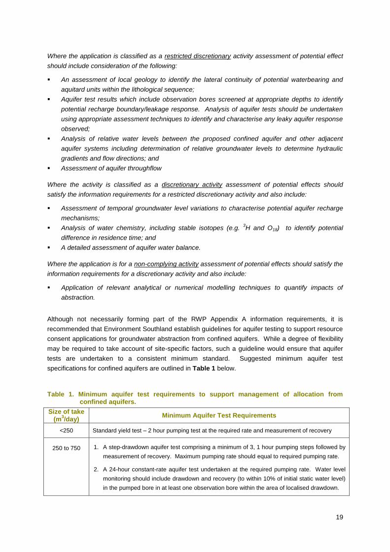
tests are undertaken to a consistent minimum standard. Suggested minimum aquifer test
specifications for confined aquifers are outlined in Table 1 below.
Table 1. Minimum aquifer test requirements to support management of allocation from confined aquifers.
Size of take (m
3/day)
Minimum Aquifer Test Requirements
<250 Standard yield test – 2 hour pumping test at the required rate and measurement of recovery
250 to 750 1. A step-drawdown aquifer test comprising a minimum of 3, 1 hour pumping steps followed by
measurement of recovery. Maximum pumping rate should equal to required pumping rate.
2. A 24-hour constant-rate aquifer test undertaken at the required pumping rate. Water level
monitoring should include drawdown and recovery (to within 10% of initial static water level)
in the pumped bore in at least one observation bore within the area of localised drawdown.
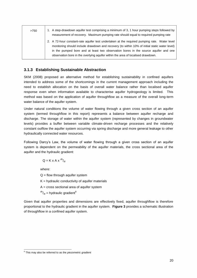
20
>750 1. A step-drawdown aquifer test comprising a minimum of 3, 1 hour pumping steps followed by
measurement of recovery. Maximum pumping rate should equal to required pumping rate
2. A 72-hour constant-rate aquifer test undertaken at the required pumping rate. Water level
monitoring should include drawdown and recovery (to within 10% of initial static water level)
in the pumped bore and at least two observation bores in the source aquifer and one
observation bore in the overlying aquifer within the area of localised drawdown.
3.1.3 Establishing Sustainable Abstraction
SKM (2008) proposed an alternative method for establishing sustainability in confined aquifers
intended to address some of the shortcomings in the current management approach including the
need to establish allocation on the basis of overall water balance rather than localised aquifer
response even when information available to characterise aquifer hydrogeology is limited. This
method was based on the application of aquifer throughflow as a measure of the overall long-term
water balance of the aquifer system.
Under natural conditions the volume of water flowing through a given cross section of an aquifer
system (termed throughflow in this report) represents a balance between aquifer recharge and
discharge. The storage of water within the aquifer system (represented by changes in groundwater
levels) provides a buffer between variable climate-driven recharge processes and the relatively
constant outflow the aquifer system occurring via spring discharge and more general leakage to other
hydraulically connected water resources.
Following Darcy‟s Law, the volume of water flowing through a given cross section of an aquifer
system is dependent on the permeability of the aquifer materials, the cross sectional area of the
aquifer and the hydraulic gradient:
Q = K x A x dh
/dl
where:
Q = flow through aquifer system
K = hydraulic conductivity of aquifer materials
A = cross sectional area of aquifer system
dh/dl = hydraulic gradient
8
Given that aquifer properties and dimensions are effectively fixed, aquifer throughflow is therefore
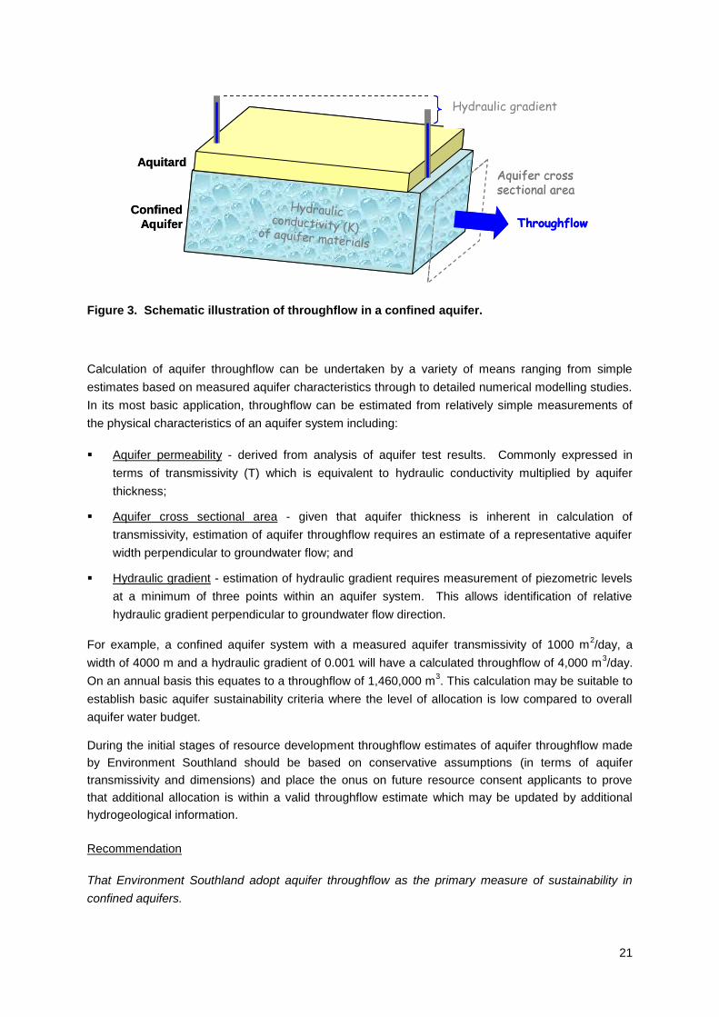
proportional to the hydraulic gradient in the aquifer system. Figure 3 provides a schematic illustration
of throughflow in a confined aquifer system.
8 This may also be referred to as the piezometric gradient
21
Piezometric gradient
Aquifer crosssectional area
Hydraulicconductivity (K) of aquifer materials
ThroughflowConfined
Aquifer
Aquitard
Piezometric gradient
Aquifer crosssectional area
Hydraulicconductivity (K) of aquifer materials
ThroughflowConfined
Aquifer
Aquitard
Figure 3. Schematic illustration of throughflow in a confined aquifer.
Calculation of aquifer throughflow can be undertaken by a variety of means ranging from simple
estimates based on measured aquifer characteristics through to detailed numerical modelling studies.
In its most basic application, throughflow can be estimated from relatively simple measurements of
the physical characteristics of an aquifer system including:
Aquifer permeability - derived from analysis of aquifer test results. Commonly expressed in
terms of transmissivity (T) which is equivalent to hydraulic conductivity multiplied by aquifer
thickness;
Aquifer cross sectional area - given that aquifer thickness is inherent in calculation of
transmissivity, estimation of aquifer throughflow requires an estimate of a representative aquifer
width perpendicular to groundwater flow; and
Hydraulic gradient - estimation of hydraulic gradient requires measurement of piezometric levels
at a minimum of three points within an aquifer system. This allows identification of relative
hydraulic gradient perpendicular to groundwater flow direction.
For example, a confined aquifer system with a measured aquifer transmissivity of 1000 m2/day, a
width of 4000 m and a hydraulic gradient of 0.001 will have a calculated throughflow of 4,000 m3/day.
On an annual basis this equates to a throughflow of 1,460,000 m3. This calculation may be suitable to
establish basic aquifer sustainability criteria where the level of allocation is low compared to overall
aquifer water budget.
During the initial stages of resource development throughflow estimates of aquifer throughflow made
by Environment Southland should be based on conservative assumptions (in terms of aquifer
transmissivity and dimensions) and place the onus on future resource consent applicants to prove
that additional allocation is within a valid throughflow estimate which may be updated by additional
hydrogeological information.
Recommendation
That Environment Southland adopt aquifer throughflow as the primary measure of sustainability in
confined aquifers.
Hydraulic gradient
22
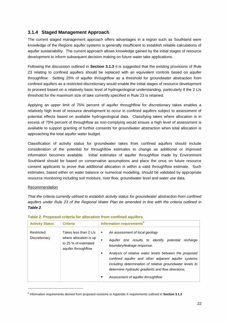
3.1.4 Staged Management Approach
The current staged management approach offers advantages in a region such as Southland were
knowledge of the Regions aquifer systems is generally insufficient to establish reliable calculations of
aquifer sustainability. The current approach allows knowledge gained by the initial stages of resource
development to inform subsequent decision making on future water take applications.
Following the discussion outlined in Section 3.1.3 it is suggested that the existing provisions of Rule
23 relating to confined aquifers should be replaced with an equivalent controls based on aquifer
throughflow. Setting 25% of aquifer throughflow as a threshold for groundwater abstraction from
confined aquifers as a restricted discretionary would enable the initial stages of resource development
to proceed based on a relatively basic level of hydrogeological understanding, particularly if the 2 L/s
threshold for the maximum size of take currently specified in Rule 23 is retained.
Applying an upper limit of 75% percent of aquifer throughflow for discretionary takes enables a
relatively high level of resource development to occur in confined aquifers subject to assessment of
potential effects based on available hydrogeological data. Classifying takes where allocation is in
excess of 75% percent of throughflow as non-complying would ensure a high level of assessment is
available to support granting of further consents for groundwater abstraction when total allocation is
approaching the total aquifer water budget.
Classification of activity status for groundwater takes from confined aquifers should include
consideration of the potential for throughflow estimates to change as additional or improved
information becomes available. Initial estimates of aquifer throughflow made by Environment
Southland should be based on conservative assumptions and place the onus on future resource
consent applicants to prove that additional allocation is within a valid throughflow estimate. Such
estimates, based either on water balance or numerical modelling, should be validated by appropriate
resource monitoring including soil moisture, river flow, groundwater level and water use data.
Recommendation
That the criteria currently utilised to establish activity status for groundwater abstraction from confined
aquifers under Rule 23 of the Regional Water Plan be amended in line with the criteria outlined in
Table 2.
Table 2. Proposed criteria for allocation from confined aquifers
Activity Status Criteria Information requirements9
Restricted
Discretionary
Takes less than 2 L/s
where allocation is up
to 25 % of estimated
aquifer throughflow
An assessment of local geology
Aquifer test results to identify potential recharge
boundary/leakage response.
Analysis of relative water levels between the proposed
confined aquifer and other adjacent aquifer systems
including determination of relative groundwater levels to
determine hydraulic gradients and flow directions;
Assessment of aquifer throughflow
9 Information requirements derived from proposed revisions to Appendix A requirements outlined in Section 3.1.2
23
Activity Status Criteria Information requirements9
Discretionary Takes greater than 2
L/s where allocation
is less than 75% of
estimated aquifer
throughflow
Hydrochemical identification of recharge sources
A detailed assessment of aquifer water balance
An assessment of the impact of abstraction on adjacent
water resources (throughflow, spring discharge leakage,
stream depletion effects
Non-Complying Allocation >75% of
estimated
throughflow
Application of relevant analytical or numerical modelling
techniques to quantify impacts of abstraction
3.1.5 Application of Minimum Level Cut-offs and Seasonal Recovery Criteria
As described in Section 2.3, application of minimum level cut-back/cut-off and seasonal recovery
conditions on individual resource consents provides a means of managing groundwater abstraction
from confined aquifers to ensure maintenance of long-term aquifer storage volumes and security of
supply for resource users.
It is noted however that establishing appropriate cut-off levels for individual resource consents can be
a subjective process, particularly when aquifer response to existing levels of allocation has not been
reliable established. As a guide it is suggested that minimum level cut-offs for initial groundwater
takes from confined aquifers should be established to ensure drawdown (at any point within the
aquifer system) does not exceed the available artesian potentiometric at any point in the aquifer (i.e.
to ensure the aquifer remains confined). Subsequent consents may have progressively higher
minimum levels established to protect the reliability of supply for first-in users based on observed
drawdown in response to abstraction.
Recommendation
That specific reference to minimum level cut-offs and seasonal recovery triggers as potential
management tools to assist sustainable management of confined aquifers be included in Policy 30.
3.1.6 Interference Effects
Policy 31 of the RWP establishes a limit for the allowable interference effect of any new groundwater
abstraction as:
„..no more than 20 percent of the available drawdown in any neighbouring bore providing the bore is
lawfully established and adequately penetrates the aquifer’.
The intent of the policy is further expanded in the explanation for the policy which states that:
„This policy sets a figure of 20 percent of the available saturated thickness below the piezometric (or
potentiomentric in the case of confined aquifers) level that is exceeded 50 percent of the time.’
In practice this policy has proved problematic to implement in confined aquifers for a number of
reasons including:
24
It does not adequately recognise differences in the nature of water level drawdown between
confined and unconfined aquifers; and
The policy explanation states that the allowable interference effect in confined aquifers is based
on a percentage of the available saturated thickness rather than the potentiometric head in the
aquifer.
The original background technical document10
covering interference effects prepared to support
Variation 2 to the Regional Water Plan proposed that the available drawdown in a confined aquifer be
defined as the „average potentiomentric head above the top of the confining layer’. The most critical
part of this definition is that it established the top of the confining layer as the maximum drawdown
available for the aquifer to remained confined (drawdown exceeding this figure will result in the aquifer
becoming locally unconfined as water is physically drained from the aquifer materials).
It is also now recognised that that establishing 20% of available drawdown as the maximum figure for
well interference fails to adequately recognise difference in drawdown characteristics between
unconfined and confined aquifers (as explained in Section 1.2) and does not include cumulative
effects of multiple groundwater takes. It is therefore suggested that the maximum cumulative
interference effect between neighbouring bores in confined aquifers be increased to 50 percent of the
potentiomentric head. This figure being more in line with potential cumulative drawdown for
groundwater takes classified as discretionary activities under the proposed amendments to Rule 23
(see Section 3.1.4).
Another issue with the existing interference effects policy include potential subjectivity in interpretation
of the policy as to whether the allowable drawdown relates to the drawdown resulting from an
individual pumped bore or the cumulative interference effect where there are multiple bores pumping
from the same aquifer.
Also, Policy 31 refers to the interference effect on bores which are „lawfully established and
adequately penetrate the aquifer’. Some issues have arisen with regard to definition of adequate
penetration in the case where existing bores and wells are of „adequate‟ depth to access water under
existing levels of allocation but may not remain so if additional allocation is granted. As a result,
further clarity is required to establish that well interference effects will be assessed based on an
assumption that bores fully penetrate the entire saturated thickness of the source aquifer.
Recommendation
That Policy 31 of the RWP be amended to clarify reference to the allowable drawdown in confined
aquifers resulting from the cumulative effects of abstraction in the source aquifer.
Limit the cumulative interference effect of any new groundwater abstraction (in conjunction with other
lawfully established groundwater takes) to no more than 20 percent of the available drawdown in an
unconfined aquifer or 50 percent of the potentiomentric head in a confined aquifer, provided the
neighbouring bore is lawfully established and fully penetrates the aquifer.
Explanation
10
Appendix 5 Interference Effects Between Bores to Variation 2 (Groundwater) to the Regional Water Plan for Southland (P:\Policy_Planning\Water Plan Development\Variation 2–Groundwater\Notified Variation & Report\Appendix 5.doc)
25
Paragraph 3....This policy sets a figure of 20 percent of the available saturated thickness below the
piezometric level (or 50 percent of potentiomentic head in the case of a confined aquifer) that is
exceeded 50 percent of the time
Paragraph 4....The interference effect of any new groundwater abstraction will be assessed as though
all existing neighbouring bores and wells fully penetrate the aquifer.
In developing policies to manage well interference effects it needs to be recognised that situations
may arise where it may be appropriate to allow well interference effects to exceed the thresholds
established in Policy 31. Such situations may include aquifer testing, construction activities or long-
term dewatering to enable mining development. Such cases are best dealt with on a individual basis
which ensures such activities are undertaken under controlled conditions where appropriate
monitoring and environmental safeguards are established.
Recommendation
Add comment regarding possible exceptions for activities including aquifer testing, construction
dewatering and mining to the explanation for Policy 31.
Given the importance of groundwater level monitoring to sustainable management of confined
aquifers it is critical that monitoring sites are not significantly impacted by localised drawdown from
individual groundwater takes. Such drawdown may have a significant impact on the quality of data
available to characterise long-terms trends in aquifer storage in response to the combined effects of
groundwater abstraction and climate variability as well as reducing the reliability of supply for
individual users who have pumping restrictions based on trigger levels in the monitoring bore. It is
therefore suggested that the interference effect resulting from abstraction from any individual bore on
a designated Environment Southland water level monitoring site be limited to less than 20 percent11
of
the potentiometric head in the monitoring bore.
Recommendation
The reference be made in Policy 31 (or a separate policy) to limit the interference effect on any
individual pumping well on any bore utilised for long-term monitoring of water levels in any confined
aquifer to no more than 20 percent of the available potentiomentric head that is exceeded 50 percent
of the time.
3.2 Fractured Rock Aquifers
As described in Section 1.2 fractured rock aquifers present a special case for management of
groundwater allocation which is distinct from that utilised for sedimentary (i.e. gravel and sand)
aquifers. In particular, due to the dependence of aquifer hydraulic properties (and consequent
groundwater storage and recharge characteristics) on local geological conditions, allocation from
these aquifer systems has to be managed on a localised rather than an aquifer-scale basis.
11
It is recognised that in a confined aquifer drawdown resulting from an individual groundwater take can extend over a relatively
extensive area. It is proposed that well interference from any individual groundwater take should not exceed 20% of the
potentiomentric head to avoid water level monitoring records being significantly impacted by localised drawdown.
26
3.2.1 Establishing Sustainable Abstraction
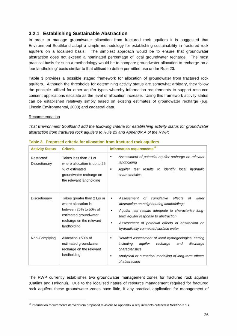
In order to manage groundwater allocation from fractured rock aquifers it is suggested that
Environment Southland adopt a simple methodology for establishing sustainability in fractured rock
aquifers on a localised basis. The simplest approach would be to ensure that groundwater
abstraction does not exceed a nominated percentage of local groundwater recharge. The most
practical basis for such a methodology would be to compare groundwater allocation to recharge on a
„per landholding‟ basis similar to that utilised to define permitted use under Rule 23.
Table 3 provides a possible staged framework for allocation of groundwater from fractured rock
aquifers. Although the thresholds for determining activity status are somewhat arbitrary, they follow
the principle utilised for other aquifer types whereby information requirements to support resource
consent applications escalate as the level of allocation increase. Using this framework activity status
can be established relatively simply based on existing estimates of groundwater recharge (e.g.
Lincoln Environmental, 2003) and cadastral data.
Recommendation
That Environment Southland add the following criteria for establishing activity status for groundwater
abstraction from fractured rock aquifers to Rule 23 and Appendix A of the RWP:
Table 3. Proposed criteria for allocation from fractured rock aquifers
Activity Status Criteria Information requirements12
Restricted
Discretionary
Takes less than 2 L/s
where allocation is up to 25
% of estimated
groundwater recharge on
the relevant landholding
Assessment of potential aquifer recharge on relevant
landholding
Aquifer test results to identify local hydraulic
characteristics.
Discretionary Takes greater than 2 L/s or
where allocation is
between 25% to 50% of
estimated groundwater
recharge on the relevant
landholding
Assessment of cumulative effects of water
abstraction on neighbouring landholdings
Aquifer test results adequate to characterise long-
term aquifer response to abstraction
Assessment of potential effects of abstraction on
hydraulically connected surface water
Non-Complying Allocation >50% of
estimated groundwater
recharge on the relevant
landholding
Detailed assessment of local hydrogeological setting
including aquifer recharge and discharge
characteristics
Analytical or numerical modelling of long-term effects
of abstraction
The RWP currently establishes two groundwater management zones for fractured rock aquifers
(Catlins and Hokonui). Due to the localised nature of resource management required for fractured
rock aquifers these groundwater zones have little, if any practical application for management of
12
Information requirements derived from proposed revisions to Appendix A requirements outlined in Section 3.1.2
27
groundwater allocation. In addition, there are also large areas where groundwater resources occur
but which are not currently included within any defined groundwater zones. These areas may include
fractured rock aquifers (i.e. in areas such as Stewart Island or Fiordland) as well as sedimentary
aquifer systems (such as in the Nokomai Valley, upper Waikaia catchment and Eastern Bush areas).
In order to manage groundwater allocation from these areas it is suggested that the methodology
proposed in Section 3.2.1 be applied to all areas (including the existing Catlins and Hokonui
groundwater zones) outside of the groundwater management zones defined in Appendix H of the
RWP. This approach would ensure all areas of Southland are included within a groundwater
allocation framework which provides a conservative methodology for establishing aquifer
sustainability.
As additional hydrogeological information becomes available, particularly in areas of sedimentary
deposits not included within existing groundwater management zones, Environment Southland may
wish to add additional groundwater management zones to Appendix H by way of a plan change to the
RWP. However, in the interim, application of the allocation methodology proposed in Section 3.2.1 to
these areas should ensure sustainable management of the groundwater resource in these areas.
Recommendation
That Environment Southland remove reference to the Catlins and Hokonui groundwater zones from
Appendix H of the RWP and identify that the proposed staged allocation framework proposed in
Section 3.2.1 apply to all areas outside the groundwater zones identified in Appendix H.
3.3 Sustainable Groundwater Management
3.3.1 Supplementary Allocation
Compliance monitoring currently indicates that in a majority of aquifer systems (including confined
aquifers) actual groundwater use is significantly lower than allocated volumes. This may occur where
water is allocated to a high level of reliability (e.g. sufficient to meet water demand in a drought event
that would occur very infrequently) meaning full allocations are rarely, if ever, fully utilised. This
results in a situation where allocative efficiency is sub-optimal (i.e. a significant proportion of water
allocated is never used)
Provided existing allocations are within sustainable limits the discrepancy between allocation and
actual use may lead to situations where it is possible to allocate more water from an aquifer system
(including confined aquifers) than is provided for within primary allocation limits established on the
basis of average annual recharge (or throughflow in the case of confined aquifers). This potential for
supplementary allocation may arise in situations where:
Actual abstraction is consistently lower than seasonal allocation; and
Groundwater level monitoring indicates that aquifer storage is sufficiently above levels required
to maintain ongoing aquifer sustainability either on an inter-annual or long-term basis; and
Where recharge to aquifer systems is enhanced by artificial means.
Supplementary groundwater allocation would be analogous to that provided for surface water in RWP
Policy 15(g)(iii) which enables water in excess of the primary allocation to be abstracted from rivers
and streams when flows are sufficiently high. This allocation is typically available only at restricted
28
times meaning it has a relatively low reliability of supply which may be suitable for storage or out-of-
season uses. A similar provision applying to groundwater would enable Environment Southland to
allocate additional water from confined aquifers if aquifer storage (due to low levels of actual use or
above average (or artificial) recharge) is more than that required to ensure the ongoing sustainability
of primary allocation (i.e. allocation made under the criteria proposed in Section 3.1.4). Such
supplementary allocation would have to be subject to appropriate minimum level cut-offs appropriate
to maintain reliability of supply for existing users and ensure long-term aquifer sustainability and may
have a low supply reliability.
Recommendation
That Environment Southland include a provision under Policy 30 that would enable supplementary
allocation of groundwater subject to appropriate controls to ensure aquifer sustainability and reliability
of supply for existing users.
3.3.2 Common Expiry Dates
Common consent expiry dates provide a potential mechanism to assist sustainable management of
groundwater allocation from confined aquifers. Such a process would enable cumulative effects from
all takes to be considered at the same time and avoid the need for individual consents applications to
be assessed as and when they expire. This would enable Environment Southland to evaluate
cumulative effects and apply appropriate management controls in a consistent and transparent
manner to all consents at the same time rather than in a relatively ad-hoc manner through the
resource consent process. Such a process would also reduce costs for consent applicants where
replacement applications for a number of consents from the same aquifer are processed concurrently.
Provision for common expiry dates is included within Proposed Plan Change 3 (Community Water
Supplies) to the RWP currently being notified by Environment Southland. Application of common
expiry date provisions contained in this variation to management of confined aquifers would
potentially offer a number of benefits in terms of efficient and consistent management of the
groundwater resource.
3.3.4 Realigning Over-Allocation
Where monitoring suggests that current levels of abstraction from a confined aquifer are not
sustainable (i.e. are resulting in an ongoing decline in groundwater storage that is inconsistent with
Policy 28), Environment Southland may be required to implement a range of measures to ensure that
allocation does not adversely impact on the sustainability of the resource. Such measures may
include:
Establishment of an aquifer users groups. Such groups can be utilised as a means to inform
consent holders in regard potential concerns regarding sustainability of the resource and to
investigate voluntary methods to reduce groundwater usage to more sustainable levels;
Initiatives to ensure efficient utilisation of water including the provision of soil moisture data to
inform management of pasture irrigation;
29
Where voluntary means are not sufficient to ensure sustainability of the resource, implementation
of pro-rata reductions in seasonal allocation through consent reviews or at the time of consent
renewal;
As an alternative to regulatory review, enabling variable seasonal allocation to be determined on
a „resource share‟ basis. This would enable Environment Southland to establish the volume of
allocation available in any given year on the basis of aquifer storage (or other hydrogeological
criteria) at a pre-determined time with the available allocation shared on a pro-rate basis between
existing resource users. Allocation on this basis may also enable establishment of different
„classes‟ of consent differentiated on the basis of supply reliability (i.e. consents that are
restricted when water availability is limited).
Recommendation
That Environment Southland continue to develop and support aquifer user groups as a primary
means to engage with resource users with regard measures ensure sustainable resource
management and investigate options for alternative methods of water allocation where issues arise
with regard the long-term sustainability of abstraction.
30
4. Summary
Recent experience with management of confined aquifers in the Northern Southland area has
highlighted shortcomings in the current management framework for groundwater allocation from
confined aquifers outlined in the Regional Water Plan for Southland (RWP). Other issue such as the
management of cumulative well interference effects are also complicated by current provisions of the
RWP.
This report provides a series of recommendations to improve the efficacy of RWP provisions relating
to the management of fractured rock and confined aquifers. These recommendations suggest a
number of amendments to the existing RWP provisions the most significant being the replacement of
the existing criteria for establishing activity status in confined aquifers on the basis of drawdown in
response to abstraction with equivalent criteria based on estimated aquifer throughflow. In order to
support these amended criteria amendments are also recommended to RWP Appendix A information
requirements as well as existing policies relating to groundwater allocation (Policy 30) and well
interference effects (Policy 31).
At the current time fractured rock aquifers are not included in the staged management framework for
groundwater allocation established in the RWP. This omission was due to a requirement to manage
allocation from these aquifers at a localised rather that aquifer-scale. In order to ensure that fractured
rock aquifers are included within the overall groundwater allocation framework for the Southland
Region, the report proposes a simple methodology for establishing activity status based on a simple
estimate of local aquifer recharge.
The report also provides a number of recommendations that may assist efficient management of
groundwater resources in the Southland Region including improved alignment between allocated
volumes and actual use, supplementary allocation, common expiry dates for resource consents and
management actions that can be adopted where monitoring results indicate groundwater abstraction
in excess of sustainable limits.
31
5. References
Alley, W.M., Reily, T.E., Franke, O.L., 1999, Sustainability of Groundwater Resources: U.S.
Geological Survey Circular 1186
Liquid Earth, 2010; Reliability of Supply for Water Allocation in Southland. Report to Environment
Southland, June 2010.
Lough, H., Williams, H., 2009; Vertical flow in Canterbury groundwater systems and its significance
for groundwater management. ECan Report No. R09/45, August 2009.
SKM, 2008: Management of Confined Aquifers in the Southland Region. Report to Environment
Southland, February 2008.


