8
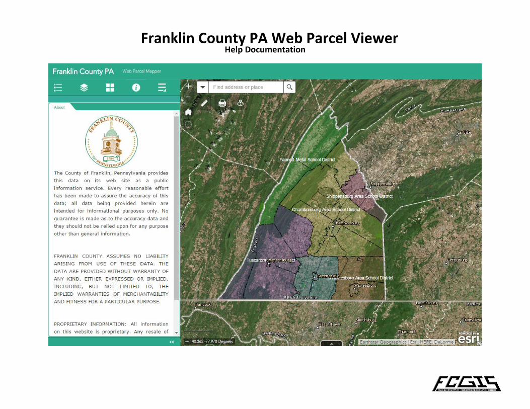
Help Documentation Franklin County PA Web Parcel Viewer
| Date post: | 29-Mar-2018 |
| Category: |
Documents |
| Upload: | vuongthuan |
| View: | 223 times |
| Download: | 3 times |
Help Documentation
Franklin County PA Web Parcel Viewer
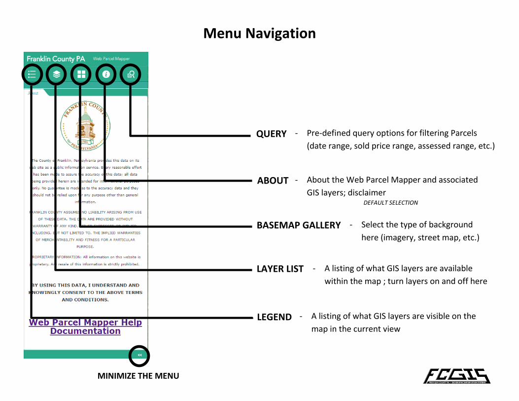
Menu Navigation
MINIMIZE THE MENU
LEGEND
LAYER LIST
BASEMAP GALLERY
ABOUT
QUERY
- A listing of what GIS layers are visible on the
map in the current view
- A listing of what GIS layers are available
within the map ; turn layers on and off here
- Select the type of background
here (imagery, street map, etc.)
- About the Web Parcel Mapper and associated
GIS layers; disclaimer
- Pre-defined query options for filtering Parcels
(date range, sold price range, assessed range, etc.)
DEFAULT SELECTION
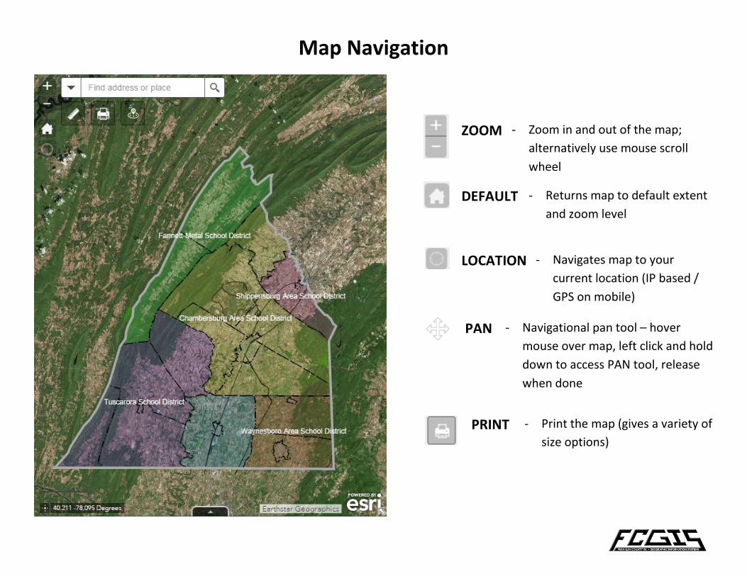
Map Navigation
ZOOM - Zoom in and out of the map;
alternatively use mouse scroll
wheel
DEFAULT - Returns map to default extent
and zoom level
LOCATION - Navigates map to your
current location (IP based /
GPS on mobile)
PAN - Navigational pan tool – hover
mouse over map, left click and hold
down to access PAN tool, release
when done
PRINT - Print the map (gives a variety of
size options)
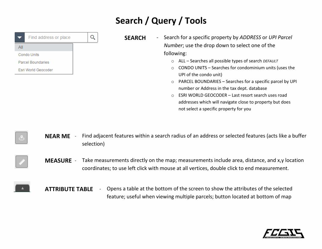
Search / Query / Tools
SEARCH - Search for a specific property by ADDRESS or UPI Parcel
Number; use the drop down to select one of the
following:
o ALL – Searches all possible types of search DEFAULT
o CONDO UNITS – Searches for condominium units (uses the
UPI of the condo unit)
o PARCEL BOUNDARIES – Searches for a specific parcel by UPI
number or Address in the tax dept. database
o ESRI WORLD GEOCODER – Last resort search uses road
addresses which will navigate close to property but does
not select a specific property for you
NEAR ME - Find adjacent features within a search radius of an address or selected features (acts like a buffer
selection)
MEASURE - Take measurements directly on the map; measurements include area, distance, and x,y location
coordinates; to use left click with mouse at all vertices, double click to end measurement.
ATTRIBUTE TABLE - Opens a table at the bottom of the screen to show the attributes of the selected
feature; useful when viewing multiple parcels; button located at bottom of map
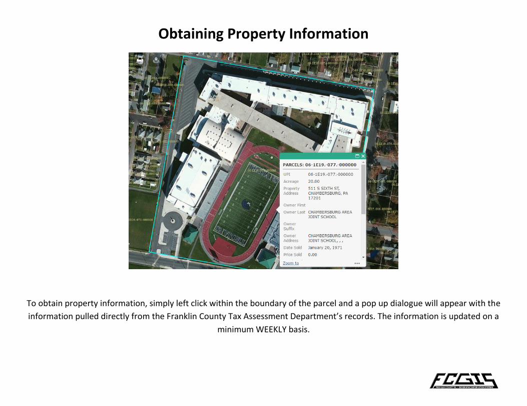
Obtaining Property Information
To obtain property information, simply left click within the boundary of the parcel and a pop up dialogue will appear with the
information pulled directly from the Franklin County Tax Assessment Department’s records. The information is updated on a
minimum WEEKLY basis.
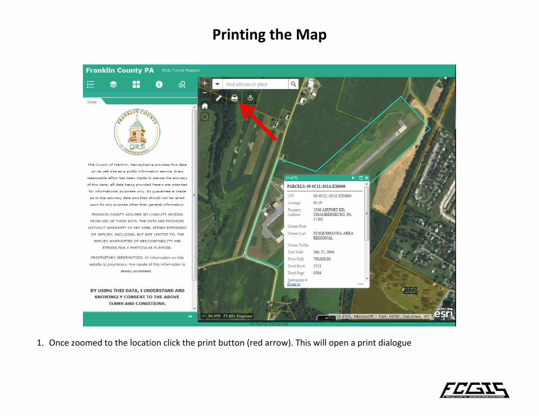
Printing the Map
1. Once zoomed to the location click the print button (red arrow). This will open a print dialogue
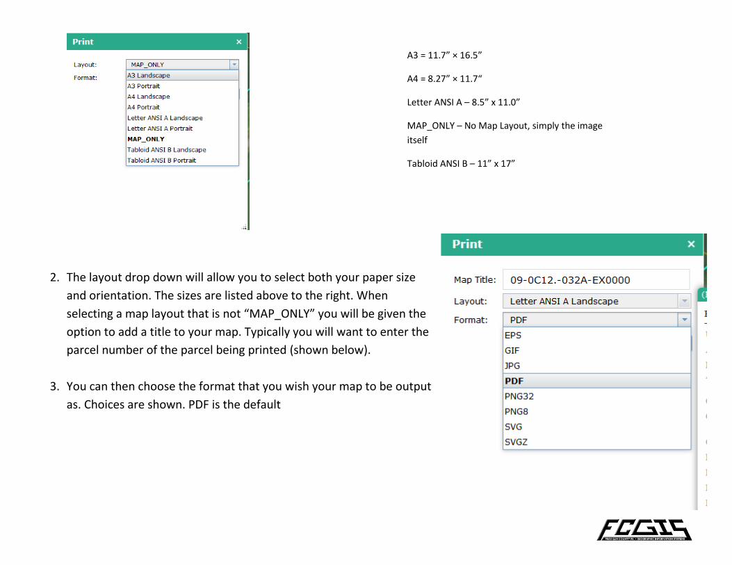
2. The layout drop down will allow you to select both your paper size
and orientation. The sizes are listed above to the right. When
selecting a map layout that is not “MAP_ONLY” you will be given the
option to add a title to your map. Typically you will want to enter the
parcel number of the parcel being printed (shown below).
3. You can then choose the format that you wish your map to be output
as. Choices are shown. PDF is the default
A3 = 11.7” × 16.5”
A4 = 8.27” × 11.7“
Letter ANSI A – 8.5” x 11.0”
MAP_ONLY – No Map Layout, simply the image
itself
Tabloid ANSI B – 11” x 17”
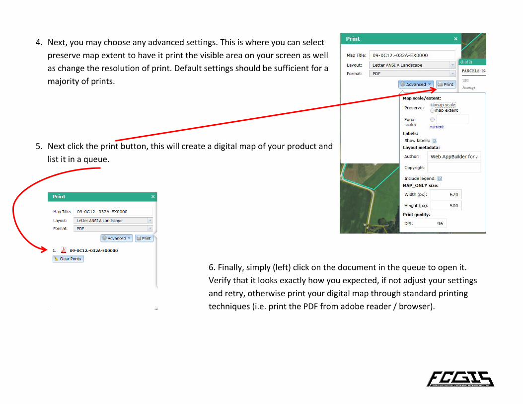
4. Next, you may choose any advanced settings. This is where you can select
preserve map extent to have it print the visible area on your screen as well
as change the resolution of print. Default settings should be sufficient for a
majority of prints.
5. Next click the print button, this will create a digital map of your product and
list it in a queue.
6. Finally, simply (left) click on the document in the queue to open it.
Verify that it looks exactly how you expected, if not adjust your settings
and retry, otherwise print your digital map through standard printing
techniques (i.e. print the PDF from adobe reader / browser).


